111
rcwatershed.org Transportation Project Guidance and Workshop Riverside County Flood Control and Water Conservation District Santa Ana Region TPG Training Updated April 24, 2018

rcwatershed.org
Transportation Project Guidance and
WorkshopRiverside County Flood Control and Water Conservation
District
Santa Ana Region TPG Training
Updated April 24, 2018

rcwatershed.orgIntroductions
Speaker Introductions: Michael J. Gentile, PE, QSD
Audience Introductions: Agencies
Departments
Other
2
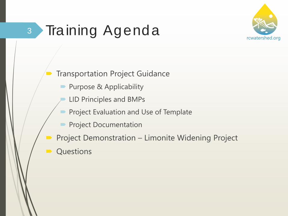
rcwatershed.orgTraining Agenda
Transportation Project Guidance Purpose & Applicability
LID Principles and BMPs
Project Evaluation and Use of Template
Project Documentation
Project Demonstration – Limonite Widening Project Questions
3

rcwatershed.orgAcronyms and Permits
BMP - Best Management Practice HCOC - Hydrologic Conditions of Concern LID - Low Impact Development MEP - Maximum Extent Practicable MSHCP - Multiple Species Habitat Conservation Plan MS4 – Municipal Separate Storm Sewer System SAR – Santa Ana River Region/Watershed TPG – Transportation Project Guidance WQMP – Water Quality Management Plan 401 – CWA §401 (Dredge/Fill) Water Quality Certification 404 – CWA §404 Permit (Discharge of Dredged/Fill Material) 1602 – CDFWC §1602 Permit (Lake and Streambed Alteration)
4

rcwatershed.org
Transportation Project Guidance
5

rcwatershed.orgPurpose & Applicability
In accordance with the Riverside County Santa Ana Region MS4 Permit, a Project-Specific Water Quality Management Plan (WQMP) is not required for Co-Permittee street, road, and highway projects.
Instead, Co-Permittees are required to develop and implement a “standardized design and post-construction BMP guidance to reduce the discharge of pollutants from such projects to the maximum extent practicable.”
Low Impact Development: Guidance and Standards for Transportation Projects for Santa Ana Region was developed for the purposes of implementing this permit provision.
Guidance is Exhibit D of the SAR WQMP Guidance Document.
6

rcwatershed.orgContent and Organization of TPG Guidance Section 1: Introduction – Purpose of the Guidance
Section 2: Project Categories
Section 3: Project Evaluation
Section 4: Source Control BMPs
Section 5: Project Implementation Requirements
Section 6: Resources
A. Glossary
B. Transportation Project BMP Template
C. LID-based BMP Planning and Design Information
7

rcwatershed.orgProject Evaluation Process Flow ChartDetermine Project Category and Applicability
Review LID Principles and BMPs
Evaluate Project-Specific Conditions/Constraints
Perform Feasibility/MEP Analysis
Document Evaluation Process, MEP Determination, and BMPs to Implement
8

rcwatershed.orgPurpose & ApplicabilityApplicability Projects Included
Guidance Applies
• Public Transportation Projects in the area covered by the Santa Ana Region MS4 Permit, which involve the construction of new transportation surfaces or the improvement of existing transportation surfaces (including Class I Bikeways and sidewalks).
Guidance Does Not Apply
• Transportation Projects that have received CEQA approval by the effective date of this Guidance (April 22, 2013)
• Emergency Projects, as defined by Guidance• Maintenance Projects, as defined by Guidance• Dirt or gravel roads• Transportation Projects part of a private new
development or significant redevelopment project and required to prepare a WQMP
• Projects subject to other MS4 Permit requirements, e.g., Caltrans oversight projects, cooperative projects with adjoining County or agency outside Santa Ana Region MS4 Permit jurisdiction
9

rcwatershed.orgPurpose & ApplicabilityApplicability Projects Included
Guidance Applies
• Public Transportation Projects in the area covered by the Santa Ana Region MS4 Permit, which involve the construction of new transportation surfaces or the improvement of existing transportation surfaces (including Class I Bikeways and sidewalks).
Guidance Does Not Apply
• Transportation Projects that have received CEQA approval by the effective date of this Guidance (April 22, 2013)
• Emergency Projects, as defined by Guidance• Maintenance Projects, as defined by Guidance• Dirt or gravel roads• Transportation Projects part of a private new
development or significant redevelopment project and required to prepare a WQMP
• Projects subject to other MS4 Permit requirements, e.g., Caltrans oversight projects, cooperative projects with adjoining County or agency outside Santa Ana Region MS4 Permit jurisdiction
10

rcwatershed.orgPurpose & Applicability11
Guidance does not apply; project may require WQMP or be subject to other MS4
Permit requirements
Has the project received CEQA approval by
Guidance effective date?
Is the proposed project required to comply with
another MS4 Permit?
Is the proposed project an emergency, maintenance or dirt/gravel road project?
Is the proposed project part of a private new
development or significant redevelopment project?
Guidance applies to the proposed project
Guidance does not apply; other MS4 Permit
requirements may apply
Will existing public roads, non-adjoining to the
development area, e.g., flag road, be improved by
a public works agency?
yes
yes
yes
yes
yes
no
no
no
no
no

rcwatershed.orgApplicability Project CategoriesCategory Project Type Guidance Applicability
1 Emergency Projects Exempt
2 Maintenance Projects Exempt
3 Existing Transportation Projects Non-Exempt
4 New Transportation Projects Non-Exempt
12
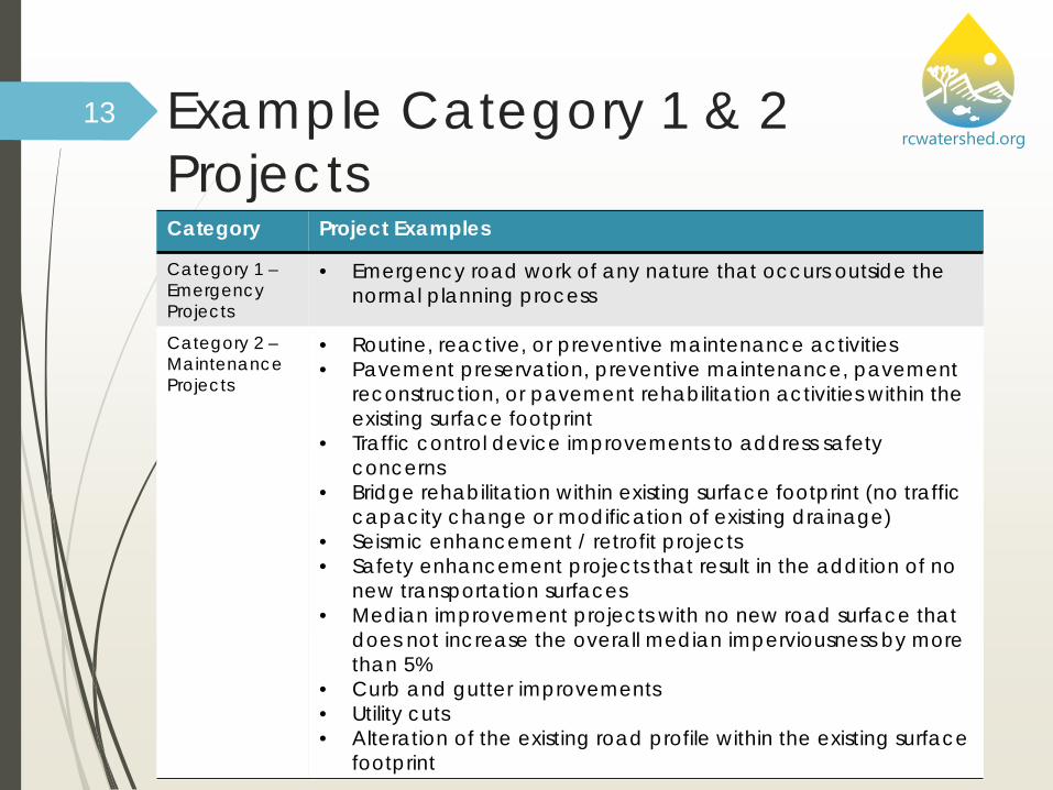
rcwatershed.orgExample Category 1 & 2 ProjectsCategory Project Examples
Category 1 –Emergency Projects
• Emergency road work of any nature that occurs outside the normal planning process
Category 2 –MaintenanceProjects
• Routine, reactive, or preventive maintenance activities • Pavement preservation, preventive maintenance, pavement
reconstruction, or pavement rehabilitation activities within the existing surface footprint
• Traffic control device improvements to address safety concerns
• Bridge rehabilitation within existing surface footprint (no traffic capacity change or modification of existing drainage)
• Seismic enhancement / retrofit projects• Safety enhancement projects that result in the addition of no
new transportation surfaces• Median improvement projects with no new road surface that
does not increase the overall median imperviousness by more than 5%
• Curb and gutter improvements• Utility cuts • Alteration of the existing road profile within the existing surface
footprint
13

rcwatershed.orgExample Category 3ProjectsCategory Project Examples
Category 3 -Roadway Capacity Improvement
• Lane additions• Bridge capacity improvements • Grade separation projects, where capacity is increased
Category 3 -Non-Capacity Roadway Improvement
• Shoulder / parking lane improvements• Turn pocket additions• Signal project that adds a turn lane• Horizontal alignment correction to improve sight distance• Grade separation projects, where no change in capacity• Addition of passing lane• Addition of a turn out• Addition of a bike lane or sidewalk that adjoins an existing
roadwayCategory 3 -Class I Bikeway & Sidewalks
• Improvements to existing Class I Bikeway or sidewalk, not adjoining a roadway
14

rcwatershed.orgExample Category 4ProjectsCategory Project Examples
Category 4 -New Transportation Projects
• New road or bridge project• New Class I Bikeway or sidewalk project, not adjoining a
roadway
15

rcwatershed.orgExample Project
Tract Development with a new major roadway WQMP Project
Does this area qualify as a TPG Project? Why? Why Not?
16

rcwatershed.orgProject Evaluation Process Flow ChartDetermine Project Category and Applicability
Review LID Principles and BMPs
Evaluate Project-Specific Conditions/Constraints
Perform Feasibility/MEP Analysis
Document Evaluation Process, MEP Determination, and BMPs to Implement
17

rcwatershed.orgLID Principles and Use of LID-Based BMPs Transportation Projects shall incorporate the following LID
Principles and BMPs to the maximum extent practicable: Conservation of natural areas to the extent feasible
Minimization of the impervious footprint
Minimization of disturbances to natural drainage
Design and construct pervious areas to receive runoff from impervious areas
Use of landscaping that minimizes irrigation and runoff, promotes surface infiltration, and minimizes the use of pesticides and fertilizers
18

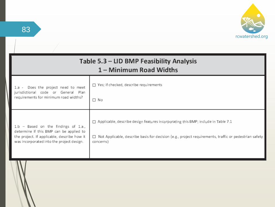
rcwatershed.orgLID-Based BMPs: Minimize Road Widths Plan site layout and road network to respect the existing
hydrologic functions of the land (preserve wetlands, buffers, high-permeability soils, etc.) and minimize the impervious area
Minimize road widths while maintaining jurisdictional code requirements for emergency service vehicles and a free flow of traffic
Look for opportunities to eliminate imperviousness within all areas of the proposed project site
19
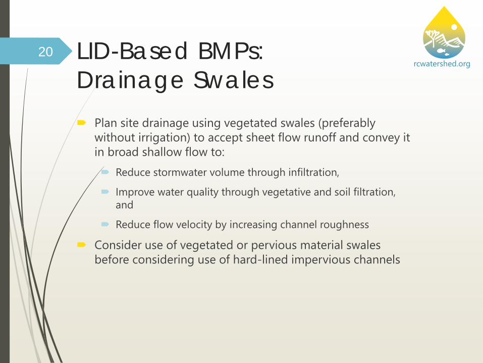
rcwatershed.orgLID-Based BMPs: Drainage Swales Plan site drainage using vegetated swales (preferably
without irrigation) to accept sheet flow runoff and convey it in broad shallow flow to: Reduce stormwater volume through infiltration,
Improve water quality through vegetative and soil filtration, and
Reduce flow velocity by increasing channel roughness
Consider use of vegetated or pervious material swales before considering use of hard-lined impervious channels
20

rcwatershed.orgLID-Based BMPs: Drainage Swales Swales traditionally have been
planted with grasses, requiring regular irrigation. If planted with drought-tolerant vegetation, swales will require little to no water once established.
Suggested criteria for Plants used in vegetated swales: Native or well-adapted to
local climate Low water use Low fertilizer requirements Minimal maintenance Attractive in all seasons
21
Bioswale Example, Low Impact Development Center, Inc.

rcwatershed.orgLID-Based BMPs: Drainage Swales Identify additional benefits
that may be attained from swales through: Amended soils Bioretention soils Gravel storage areas Underdrains Weirs Thick diverse vegetation,
including, where possible, use of native vegetation
What areas would swales be feasible?
22
Green Streets: EPA-833-F-09-002, August 2009, www.epa.gov/greeninfrastructure

rcwatershed.orgLID-Based BMPs: Drainage Swales
23
Photo Credit: Jeff Potts, City of Corona
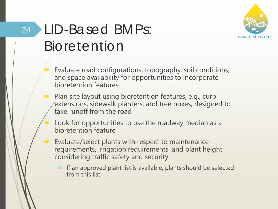
rcwatershed.orgLID-Based BMPs: Bioretention Evaluate road configurations, topography, soil conditions,
and space availability for opportunities to incorporate bioretention features
Plan site layout using bioretention features, e.g., curb extensions, sidewalk planters, and tree boxes, designed to take runoff from the road
Look for opportunities to use the roadway median as a bioretention feature
Evaluate/select plants with respect to maintenance requirements, irrigation requirements, and plant height considering traffic safety and security If an approved plant list is available, plants should be selected
from this list.
24

rcwatershed.orgLID-Based BMPs: Bioretention
25
Green Streets: EPA-833-F-09-002, August 2009, www.epa.gov/greeninfrastructure
Green Streets: EPA-833-F-08-009, December 2008, water.epa.gov/infrastructure/greeninfrastructure

rcwatershed.orgLID-Based BMPs:Bioretention
26
Photo Credit: Jeff Potts, City of Corona

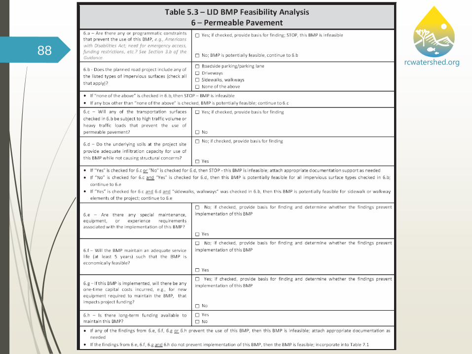
rcwatershed.orgLID-Based BMPs: Permeable Pavement Plan low speed and parking
areas within a site layout for incorporating permeable pavement
Evaluate permeable gutters Evaluate permeable concrete,
permeable asphalt, permeable interlocking concrete pavers, and grid pavers as alternatives to conventional, less pervious concrete and asphalt surfaces
Incorporate an aggregate base to provide structural support, runoff storage, and pollutant removal through filtering and adsorption
27
Green Streets: EPA-833-F-09-002, August 2009, www.epa.gov/greeninfrastructure

rcwatershed.orgLID-Based BMPs: Sidewalk Trees and Tree Boxes
Evaluate site opportunities to incorporate tree cover into site layout, e.g., using sidewalk tree features and tree boxes
Provide sufficient uncompacted soil and space for proper tree health/growth via larger tree boxes, structural soils, root paths, or "silva cells" that allow sufficient tree root space
28
Green Streets: EPA-833-F-09-002, August 2009, www.epa.gov/greeninfrastructure

rcwatershed.orgLID-Based BMPs: Sidewalk Trees and Tree Boxes
Consider sufficient tree space in the right-of-way while maintaining traffic and pedestrian safety
Consider sufficient tree space for root growth to prevent road structural impacts
Evaluate space for trees versus added construction costs
Evaluate species water needs and availability of irrigation
29
Green Streets: EPA-833-F-09-002, August 2009, www.epa.gov/greeninfrastructure

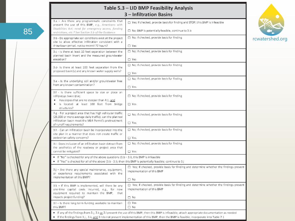
rcwatershed.orgLID-Based BMPs: Infiltration Basins Infiltration basins can have high pollutant removal efficiency
and can reduce flows to mimic pre-development hydrologic conditions
Plan roadway drainage to be directed away from the road surface to infiltration basins Typical detention or retention basins may be designed as
infiltration facilities in some cases, with the ability to store runoff until it gradually exfiltrates through the soil
72-hour drawn down is usually recommended
Use of infiltration BMPs shall be consistent with the pretreatment of runoff prior to infiltration requirements established by the MS4 Permit for areas subject to high vehicular traffic (25,000 or more average daily traffic)
30

rcwatershed.orgLID-Based BMPs: Infiltration Basins Use of infiltration basins
should consider: Appropriate soil
conditions for infiltration and potential site constraints
Groundwater separation should be at least 10 feet from the basin invert to the measured groundwater elevation
Traffic / pedestrian safety and site aesthetics
31
www.casqa.org – California BMP Handbooks

rcwatershed.orgLID-Based BMPs: Infiltration Basins Reference the County's
design criteria for infiltration basins to be consistent with design requirements (note that Caltrans also has design requirements for basins in their right-of-way)
32
www.casqa.org – California BMP Handbooks

rcwatershed.orgBMP Example: Curb Extensions
33
water.epa.gov/aboutow/eparecovery/upload/2009_09_10_eparecovery_EPA_ARRA_Green_Streets_FINAL.pdf
Source: Green Streets: EPA-833-F-09-002, August 2009,

rcwatershed.orgBMP Example: Curb Extensions
34
water.epa.gov/aboutow/eparecovery/upload/2009_09_10_eparecovery_EPA_ARRA_Green_Streets_FINAL.pdf
Source: Green Streets: EPA-833-F-09-002, August 2009,

rcwatershed.orgBMP Example: Vegetated Swales
35
water.epa.gov/aboutow/eparecovery/upload/2009_09_10_eparecovery_EPA_ARRA_Green_Streets_FINAL.pdf
Source: Green Streets: EPA-833-F-09-002, August 2009,

rcwatershed.orgBMP Example: Vegetated Swales
36
water.epa.gov/aboutow/eparecovery/upload/2009_09_10_eparecovery_EPA_ARRA_Green_Streets_FINAL.pdf
Source: Green Streets: EPA-833-F-09-002, August 2009,

rcwatershed.orgBMP Example: Permeable Pavement
37
water.epa.gov/aboutow/eparecovery/upload/2009_09_10_eparecovery_EPA_ARRA_Green_Streets_FINAL.pdf
Source: Green Streets: EPA-833-F-09-002, August 2009,

rcwatershed.orgBMP Example: Permeable Pavement
38
water.epa.gov/aboutow/eparecovery/upload/2009_09_10_eparecovery_EPA_ARRA_Green_Streets_FINAL.pdf
Source: Green Streets: EPA-833-F-09-002, August 2009,

rcwatershed.orgBMP Example: Planters
39
water.epa.gov/aboutow/eparecovery/upload/2009_09_10_eparecovery_EPA_ARRA_Green_Streets_FINAL.pdf
Source: Green Streets: EPA-833-F-09-002, August 2009,

rcwatershed.orgIntegrative Design:Complete Streets
40
Source: Complete Streets are Green Streetshttp://anr.vermont.gov/sites/anr/files/specialtopics/muniday/documents/
Complete-Streets-are-Green-Streets-Municipal-Day-Sept-2015.pdf

rcwatershed.orgIntegrative Design:Complete Streets
41
Source: Complete Streets are Green Streetshttp://anr.vermont.gov/sites/anr/files/specialtopics/muniday/documents/
Complete-Streets-are-Green-Streets-Municipal-Day-Sept-2015.pdf

rcwatershed.orgIntegrative Design:Complete Streets
42
Source: Complete Streets are Green Streetshttp://anr.vermont.gov/sites/anr/files/specialtopics/muniday/documents/
Complete-Streets-are-Green-Streets-Municipal-Day-Sept-2015.pdf

rcwatershed.orgDiscussion:Complete Street Opportunities
43
Source: Watts Green Streets, p. 34http://wattsreimagined.org/wp-content/uploads/2015/04/Exhibit-3.1-
Watts-Greenstreets.pdf

rcwatershed.orgDiscussion:Complete Street Opportunities
44
Source: Watts Green Streets, p. 34http://wattsreimagined.org/wp-content/uploads/2015/04/Exhibit-3.1-
Watts-Greenstreets.pdf
rcwatershed.orgIntegrative Design:The Complete Street Advantage
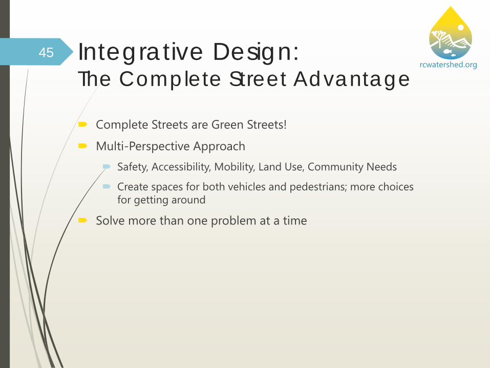
Complete Streets are Green Streets!
Multi-Perspective Approach Safety, Accessibility, Mobility, Land Use, Community Needs
Create spaces for both vehicles and pedestrians; more choices for getting around
Solve more than one problem at a time
45

rcwatershed.orgProject Evaluation Process Flow ChartDetermine Project Category and Applicability
Review LID Principles and BMPs
Evaluate Project-Specific Conditions/Constraints
Perform Feasibility/MEP Analysis
Document Evaluation Process, MEP Determination, and BMPs to Implement
46

rcwatershed.orgPotential Project Constraints
Regulatory Requirements TMDL/Impaired Waters
requirements Environmentally sensitive areas CEQA mitigation measures 401 cert / 404 Permit, Section
1602
Site-specific Characteristics Drainage characteristics Soil characteristics, geologic
conditions Elevated groundwater
conditions Groundwater protection areas Natural sediment loads
Infrastructure & Project-specific Characteristics Programmatic or funding
restrictions Right-of-way constraints Existing features (drainage,
curb and gutter, grades, etc.) Utility constraints (e.g.,
pipelines, cables) Availability of irrigation water Availability of power Types of traffic loads Maintenance resources and
expertise
47

rcwatershed.orgPotential Project Constraints
Regulatory Requirements TMDL/Impaired Waters
requirements Environmentally sensitive areas CEQA mitigation measures 401 cert / 404 Permit, Section
1602
Site-specific Characteristics Drainage characteristics Soil characteristics, geologic
conditions Elevated groundwater
conditions Groundwater protection areas Natural sediment loads
Infrastructure & Project-specific Characteristics Programmatic or funding
restrictions Right-of-way constraints Existing features (drainage,
curb and gutter, grades, etc.) Utility constraints (e.g.,
pipelines, cables) Availability of irrigation water Availability of power Types of traffic loads Maintenance resources and
expertise
48
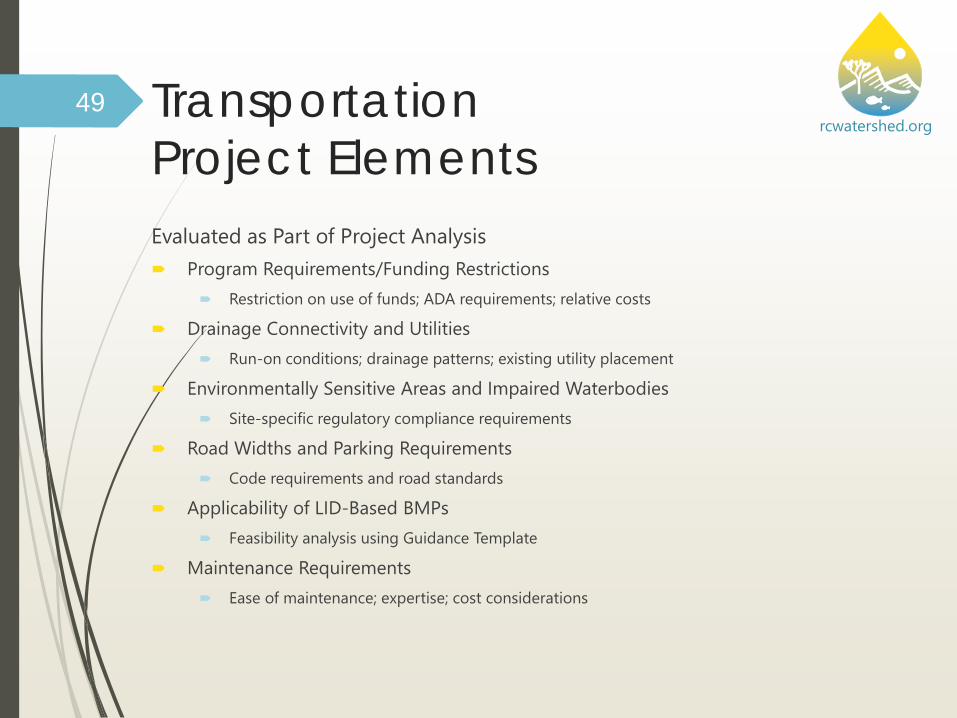
rcwatershed.orgTransportation Project ElementsEvaluated as Part of Project Analysis Program Requirements/Funding Restrictions
Restriction on use of funds; ADA requirements; relative costs
Drainage Connectivity and Utilities Run-on conditions; drainage patterns; existing utility placement
Environmentally Sensitive Areas and Impaired Waterbodies Site-specific regulatory compliance requirements
Road Widths and Parking Requirements Code requirements and road standards
Applicability of LID-Based BMPs Feasibility analysis using Guidance Template
Maintenance Requirements Ease of maintenance; expertise; cost considerations
49

rcwatershed.orgProject Evaluation Process Flow ChartDetermine Project Category and Applicability
Review LID Principles and BMPs
Evaluate Project-Specific Conditions/Constraints
Perform Feasibility/MEP Analysis
Document Evaluation Process, MEP Determination, and BMPs to Implement
50

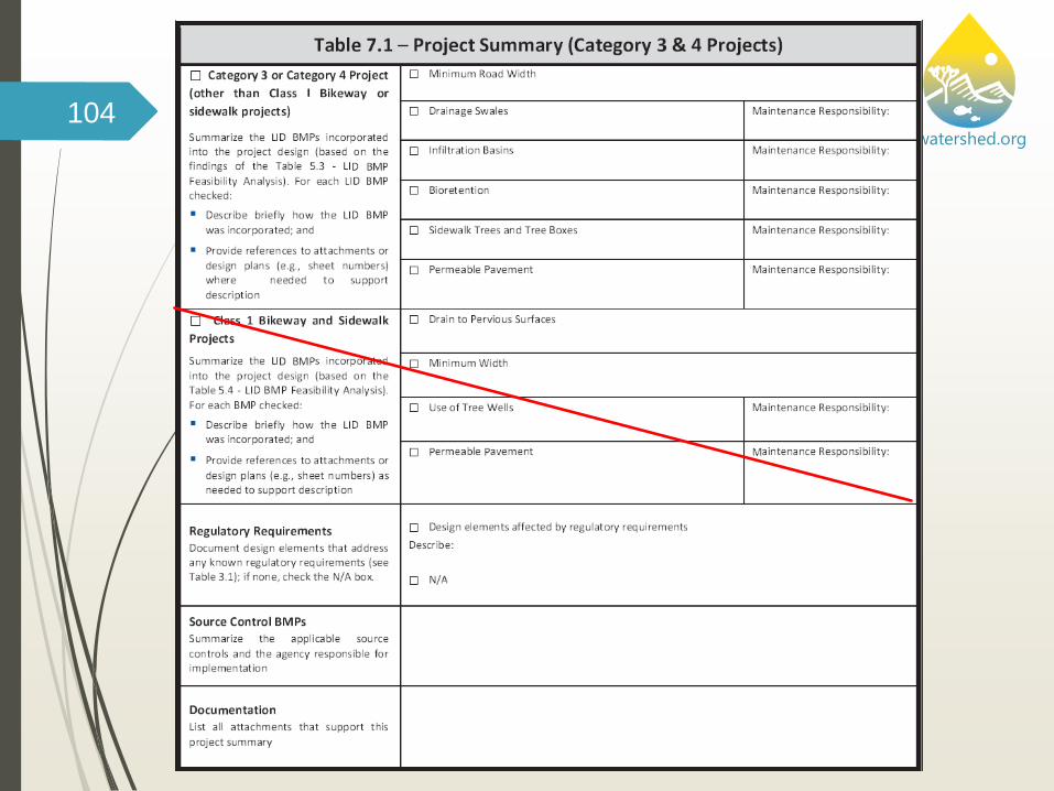
rcwatershed.orgBMP Feasibility Analysis –Guidance Template Exhibit D of the WQMP (the TPG)
includes information on conducting the feasibility analysis TPG Section 3.B provides a
general overview
TPG Section 6 includes a Template
TPG Template Table 5.1 BMPs to Evaluate
Table 5.2 BMP Design Information
Table 5.3 – LID BMP Feasibility Analysis for Trans. Projects
Table 5.4 – LID BMP Feasibility Analysis for Class I Bikeways and Sidewalks
51

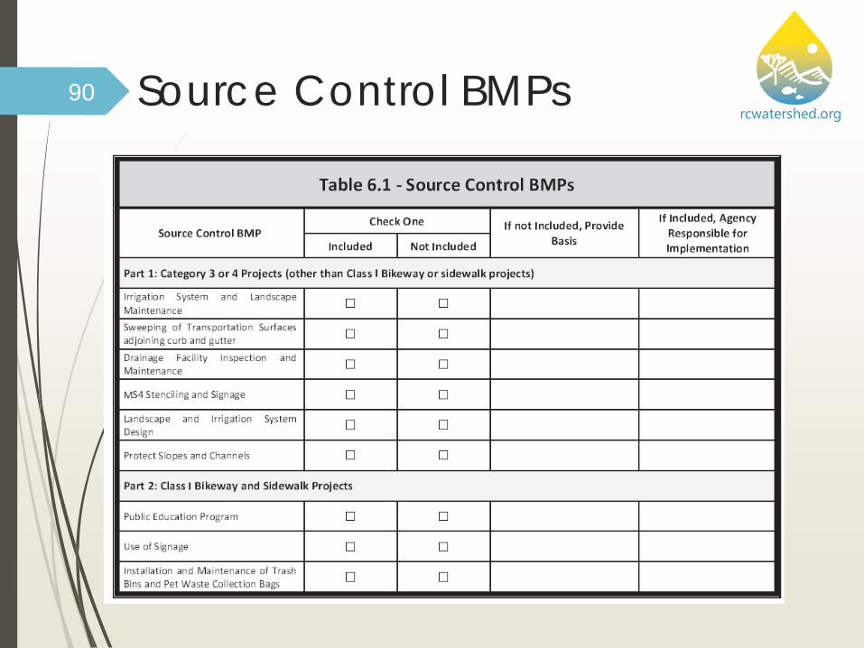
rcwatershed.orgSource Control ConsiderationsProject Type Non-Structural BMPs Structural BMPs
Category 3 or 4 Road Projects
• Irrigation System and Landscape Maintenance
• Sweeping of Transportation Surfaces Adjoining Curb and Gutter
• Drainage Facility Inspection and Maintenance
• MS4 Stenciling and Signage
• Landscape and Irrigation System Design
• Protection of Slopes and Channels
Class I Bikeway or Sidewalk Projects
• Public Education Program
• Use of Signage• Installation and
Maintenance of Trash Bins and Pet Waste Collection Bags
None identified in Guidance
52

rcwatershed.orgProject Evaluation Process Flow ChartDetermine Project Category and Applicability
Review LID Principles and BMPs
Evaluate Project-Specific Conditions/Constraints
Perform Feasibility/MEP Analysis
Document Evaluation Process, MEP Determination, and BMPs to Implement
53

rcwatershed.orgProject Documentation Requirements
Category Documentation Requirements
Additional Considerations
Category 1 & 2Emergency
and Maintenance
Projects
Document that Guidance and the implementation of LID-based BMP practices did not apply to the proposed project
• Maintain this documentation along with all other information required for approval and permitting the proposed project within the project files
Category 3 & 4Existing and
New Transportation
Projects
Incorporate following supplemental documentation in the project development file: • Project
category and type
• Site constraints• Feasibility
analysis findings• LID-based BMPs
incorporated into the project
• Document basis for funding restrictions limiting application of BMPs
• BMPs documented via supplementary document to the proposed project plans, such as contract documents or specifications, or directly within the project plans as plan notes
• Project plans and file documentation will show/describe the types, sizes, and locations of proposed BMP techniques -project BMP sizing documentation (Appendix A of Template must be included)
• Maintain this documentation along with all other information required for approval and permitting the proposed project within the project files
54

rcwatershed.org
Project Demonstration55

rcwatershed.orgLimonite Avenue Project Example Project Description
Project Information
LID BMP Evaluation
Source Control BMPs
BMP Sizing
Observations/learning experiences
56

rcwatershed.org
Project Description
57

rcwatershed.orgLimonite Avenue Project Description Existing two-lane (one lane in each direction) roadway from
Etiwanda to Downey Street City of Jurupa Valley General Plan, has Limonite Avenue as a
six-lane Urban Arterial with 152’ of ultimate right of way The City proposes interim improvements to a four-lane
roadway with a center left turn or painted median from Etiwanda Avenue to Bain Street
Interim project will address the immediate traffic needs and minimize traffic congestion in peak hour traffic
Project is within the City jurisdiction; however, City has requested the County of Riverside to take lead to perform preliminary engineering and environmental clearance
58

rcwatershed.orgCurrent Status
Project in preliminary design stage Reviewed recent in-progress working drawings and
compared with concept drawings used for prior training in Dec. 2012
No major changes in alignment or significant details
Previous drawings had areal map background so have continued to use these for training
Discussed several ideas with County design team and incorporated new info on county-owned property
Project also undergoing environmental review
59

rcwatershed.org
Parcels owned by Riverside County

rcwatershed.orgTypical Cross-Section (varies depending upon available ROW)
61

rcwatershed.orgApplicability of the Transportation Project Guidance to Proposed ProjectTable 1.1. Transportation Project Guidance Applicability
The Transportation Project Guidance applies to the following projects:
• Public Transportation Projects in the area covered by the Santa Ana Region MS4 Permit, which involve the construction of new transportation surfaces or the improvement of existing transportation surfaces (including Class I Bikeways and sidewalks)
The Transportation Project Guidance does not apply to the following projects that are either exempt or covered by other MS4 Permit requirements:
• Transportation Projects that have received CEQA approval by the effective date of this Guidance
• Emergency Projects, as defined by this Guidance (see Section 2 of the Guidance)• Maintenance Projects, as defined by this Guidance (see Section 2 of the Guidance)• Dirt or gravel roads• Transportation Projects that are part of a private new development or significant
redevelopment project and required to prepare a Water Quality Management Plan (WQMP)
• Transportation Projects subject to other MS4 Permit requirements, e.g., California Transportation Department (Caltrans) oversight projects, cooperative projects with an adjoining County or an agency outside the jurisdiction covered by the Santa Ana Region MS4 Permit.
62

rcwatershed.org63
Guidance does not apply; project may require WQMP or be subject to other MS4
Permit requirements
Has the project received CEQA approval by
Guidance effective date?
Is the proposed project required to comply with
another MS4 Permit?
Is the proposed project an emergency, maintenance or dirt/gravel road project?
Is the proposed project part of a private new
development or significant redevelopment project?
Guidance applies to the proposed project
Guidance does not apply; other MS4 Permit
requirements may apply
Will existing public roads, non-adjoining to the
development area, e.g., flag road, be improved by
a public works agency?
yes
yes
yes
yes
yes
no
no
no
no
no

rcwatershed.org64
Guidance does not apply; project may require WQMP or be subject to other MS4
Permit requirements
Has the project received CEQA approval by
Guidance effective date?
Is the proposed project required to comply with
another MS4 Permit?
Is the proposed project an emergency, maintenance or dirt/gravel road project?
Is the proposed project part of a private new
development or significant redevelopment project?
Guidance applies to the proposed project
Guidance does not apply; other MS4 Permit
requirements may apply
Will existing public roads, non-adjoining to the
development area, e.g., flag road, be improved by
a public works agency?
yes
yes
yes
yes
yes
no
no
no
no
no

rcwatershed.org65
Guidance does not apply; project may require WQMP or be subject to other MS4
Permit requirements
Has the project received CEQA approval by
Guidance effective date?
Is the proposed project required to comply with
another MS4 Permit?
Is the proposed project an emergency, maintenance or dirt/gravel road project?
Is the proposed project part of a private new
development or significant redevelopment project?
Guidance applies to the proposed project
Guidance does not apply; other MS4 Permit
requirements may apply
Will existing public roads, non-adjoining to the
development area, e.g., flag road, be improved by
a public works agency?
yes
yes
yes
yes
yes
no
no
no
no
no

rcwatershed.org66
Guidance does not apply; project may require WQMP or be subject to other MS4
Permit requirements
Has the project received CEQA approval by
Guidance effective date?
Is the proposed project required to comply with
another MS4 Permit?
Is the proposed project an emergency, maintenance or dirt/gravel road project?
Is the proposed project part of a private new
development or significant redevelopment project?
Guidance applies to the proposed project
Guidance does not apply; other MS4 Permit
requirements may apply
Will existing public roads, non-adjoining to the
development area, e.g., flag road, be improved by
a public works agency?
yes
yes
yes
yes
yes
no
no
no
no
no

rcwatershed.org67
Guidance does not apply; project may require WQMP or be subject to other MS4
Permit requirements
Has the project received CEQA approval by
Guidance effective date?
Is the proposed project required to comply with
another MS4 Permit?
Is the proposed project an emergency, maintenance or dirt/gravel road project?
Is the proposed project part of a private new
development or significant redevelopment project?
Guidance applies to the proposed project
Guidance does not apply; other MS4 Permit
requirements may apply
Will existing public roads, non-adjoining to the
development area, e.g., flag road, be improved by
a public works agency?
yes
yes
yes
yes
yes
no
no
no
no
no
Project is a Category 3 – Roadway Capacity Improvement Project

rcwatershed.org68
TPG TemplateFigure 1-1Page 6-13

rcwatershed.org69
TPG TemplateFigure 1-1Page 6-13
rcwatershed.org
ProjectInformation
70

rcwatershed.org71

rcwatershed.org72
15,000 (rough) 5,280
N/A

rcwatershed.org73
Middle Santa Ana River Bacteria TMDL

rcwatershed.orgHydrologic Soil Groups74
Mixture of soil types. Soils in middle of alignment are generally A soils – favorable for infiltration
Source: USDA NRCS Web Soil survey, Accessed 2014

rcwatershed.orgDepth to Groundwater75
Approximate Groundwater Elevation 610-615 MSL

rcwatershed.org76
El. 678 El. 682
El. 643 El. 648 El. 693
Depth to GW > 10 ft
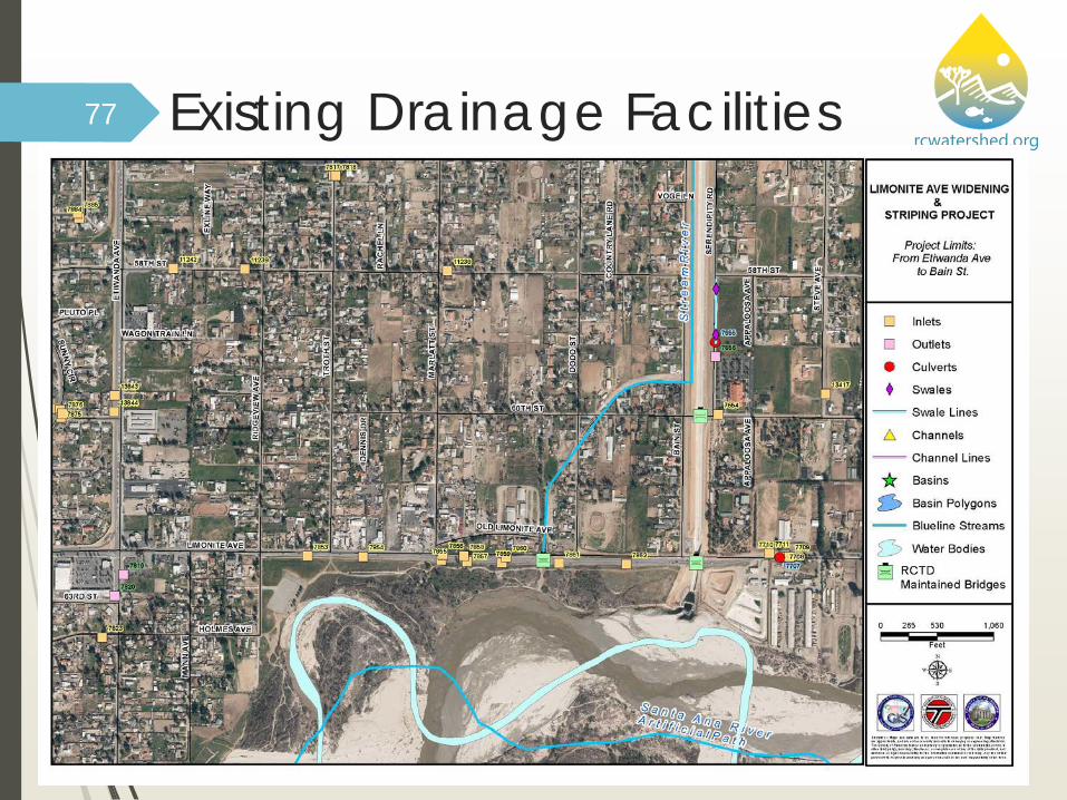
rcwatershed.orgExisting Drainage Facilities77

rcwatershed.org78

rcwatershed.org79

rcwatershed.org
LID BMP Evaluation
80

rcwatershed.org81

rcwatershed.org82
rcwatershed.org83

rcwatershed.org84
rcwatershed.org85

rcwatershed.org86

rcwatershed.org87
rcwatershed.org88

rcwatershed.org
Source ControlBMPs
89
rcwatershed.orgSource Control BMPs90

rcwatershed.org
BMP Sizing91

rcwatershed.orgSizing Steps
Delineate drainage areas
Look up sizing method and calculate target sizing criteria (Table 5.2)
Appropriately design BMPs using guidance links (Table 5.2)
Attempt to design BMPs to meet full sizing criteria
If full sizing criteria cannot be met, documents constraints and provide largest portion that can be reasonably provided within constraints
92

rcwatershed.org93

rcwatershed.org94
Design Storm Volume = approx. 0.75 in.

rcwatershed.orgCalculate DCV or Design Storm Flow Divide alignment into drainage areas
Calculate area and % imperviousness of each drainage area
Determine feasible BMP type for each drainage area
Calculate DCV or Design Storm Flow to be used to size each BMP
Infiltration based BMPs use DCV for sizing (e.g. drainage swales with infiltration, bioretention)
Refer to RCFCWCD LID Handbook and other references for design details
95
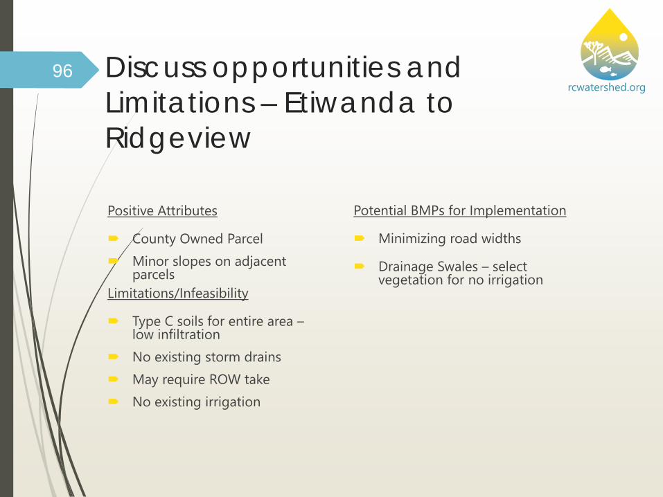
rcwatershed.orgDiscuss opportunities and Limitations – Etiwanda to Ridgeview
Positive Attributes
County Owned Parcel Minor slopes on adjacent
parcelsLimitations/Infeasibility
Type C soils for entire area –low infiltration
No existing storm drains May require ROW take No existing irrigation
Potential BMPs for Implementation
Minimizing road widths
Drainage Swales – select vegetation for no irrigation
96

rcwatershed.orgOpportunities & Limitations:Etiwanda to Ridgeview
Positive Attributes
County Owned Parcel
Minor slopes on adjacent parcels
97
Potential BMPs for Implementation
Minimizing road widths
Drainage Swales – select vegetation for no irrigation
Limitations/Infeasibility
Type C soils for entire area – low infiltration
No existing storm drains
May require ROW take
No existing irrigation
El. 678 El. 682
Flow Direction

rcwatershed.orgOpportunities & Limitations:Ridgeview to beyond Troth St.
Positive Attributes
Type A soil areas on east end
Minor slopes on adjacent parcels
98
Potential BMPs for Implementation
Minimizing road widths
Bioretention areas on west end
Infiltration on east end
Drainage Swales – select vegetation due to no irrigation
Limitations/Infeasibility
Type C soils for west area – low infiltration
No existing storm drains
May require ROW take
No existing irrigation
El. 682
Flow Direction

rcwatershed.orgOpportunities & Limitations:Marlett St. to Dodd St.
Positive Attributes
Type A soils on each end
County of Riverside owned parcel
Existing drainage outlets to lower retention areas
99
Potential BMPs for Implementation
Minimizing road widths
Infiltration areas on each end
Drainage Swales – select vegetation for no irrigation
Limitations/Infeasibility
Type A/D soils in low point – low infiltration
Areas of adjacent steep slopes in A soil areas
No existing storm drains
No existing irrigation
El. 643
Flow Direction
El. 639 El. 648

rcwatershed.orgCurrent Preliminary Design Drawings
100
Green Areas = OpportunitiesPotential retention areas
Red Areas = Constraints/LimitationsHigher elevs areas

rcwatershed.orgOpportunities & Limitations:Dodd St. to Bain St.
Positive Attributes
Minor slopes on adjacent parcels
Adjacent natural area on north side
Existing drainage channel
101
Potential BMPs for Implementation
Minimizing road widths
Drainage Swales – select vegetation for no irrigation
Limitations/Infeasibility
Type C soils – low infiltration
No existing storm drains
No existing irrigation
Flow Direction
El. 648El. 648

rcwatershed.orgLID-Based BMPs: Drainage Swales Identify additional benefits
that may be attained from swales through: Amended soils
Bioretention soils
Gravel storage areas
Underdrains
Weirs
Thick diverse vegetation, including, where possible, use of native vegetation
102
Green Streets: EPA-833-F-09-002, August 2009, www.epa.gov/greeninfrastructure
Bioswsale Example., Low Impact Development Center, Inc.

rcwatershed.orgLID-Based BMPs: Drainage Swales Plan site drainage using vegetated swales (preferably
without irrigation) to accept sheet flow runoff and convey it in broad shallow flow to: Reduce stormwater volume through infiltration,
Improve water quality through vegetative and soil filtration, and
Reduce flow velocity by increasing channel roughness
Consider use of vegetated or pervious material swales before considering use of hard-lined impervious channels
103
rcwatershed.org104

rcwatershed.org
Additional Items to Include
105

rcwatershed.orgTransportation Site Plan
Include TPG Project Site Plan showing all BMP locations.
106

rcwatershed.orgTransportation Site Plan Items Vicinity Map (may be a separate page) Project boundary (may be separate plan showing overall boundary) Pervious areas Impervious areas DA boundaries and flow arrows (may be separate sheets) Each DA LID DCV Design elevations and benchmark utilized Pre- and Post-topography LID BMP details and x-sections (may be separate sheets) Drainage connections (may be separate sheets) All source control BMPs identified Standard site plan labeling
107

rcwatershed.orgOPERATION AND MAINTENANCE Identify all O&M requirements for all LID
BMPs
O&M documentation should:
Designate responsible party that will manage the BMPs
Detail maintenance frequency – indicating minimum requirements
Detail maintenance activities – specific activity and waste placement
Detail routine service and updating schedule – e.g. update training annually
BMP Factsheets
Discuss any other necessary maintenance /irrigation activity
108

rcwatershed.orgFiling the Transportation BMP Documentation Transportation BMP Documentation should be kept in the
Project file
Transportation BMP Documentation should also be provided to Public Works, or other appropriate Department, to ensure O&M of all LID BMPs
109

rcwatershed.orgDocument Certification
Transportation Project BMP document requires certification.
Certification Recommendations:
Stamped and signed by the Engineer of Record, and
Certified by Agency Representative responsible for approval of Project
110

rcwatershed.org
Questions111


