74
Park 564 - Big Marsh Schematic Design June 27, 2014
| Date post: | 23-Apr-2018 |
| Category: |
Documents |
| Upload: | nguyenkhanh |
| View: | 213 times |
| Download: | 0 times |

Park 564 - Big MarshSchematic Design
June 27, 2014

Par
k 56
4 - B
ig M
arsh
Mas
ter P
lan
2
ACKNOWLEDGMENTS
City of ChicagoMayor Rahm Emanuel
Alderman John Pope
Chicago Park District Board of Commissioners
President Bryan Traubert
Vice President Avis LaVelle
Commissioner Erika R. Edwards
Commissioner Donald J. Edwards
Commissioner Martin Laird Koldyke
Commissioner Juan Salgado
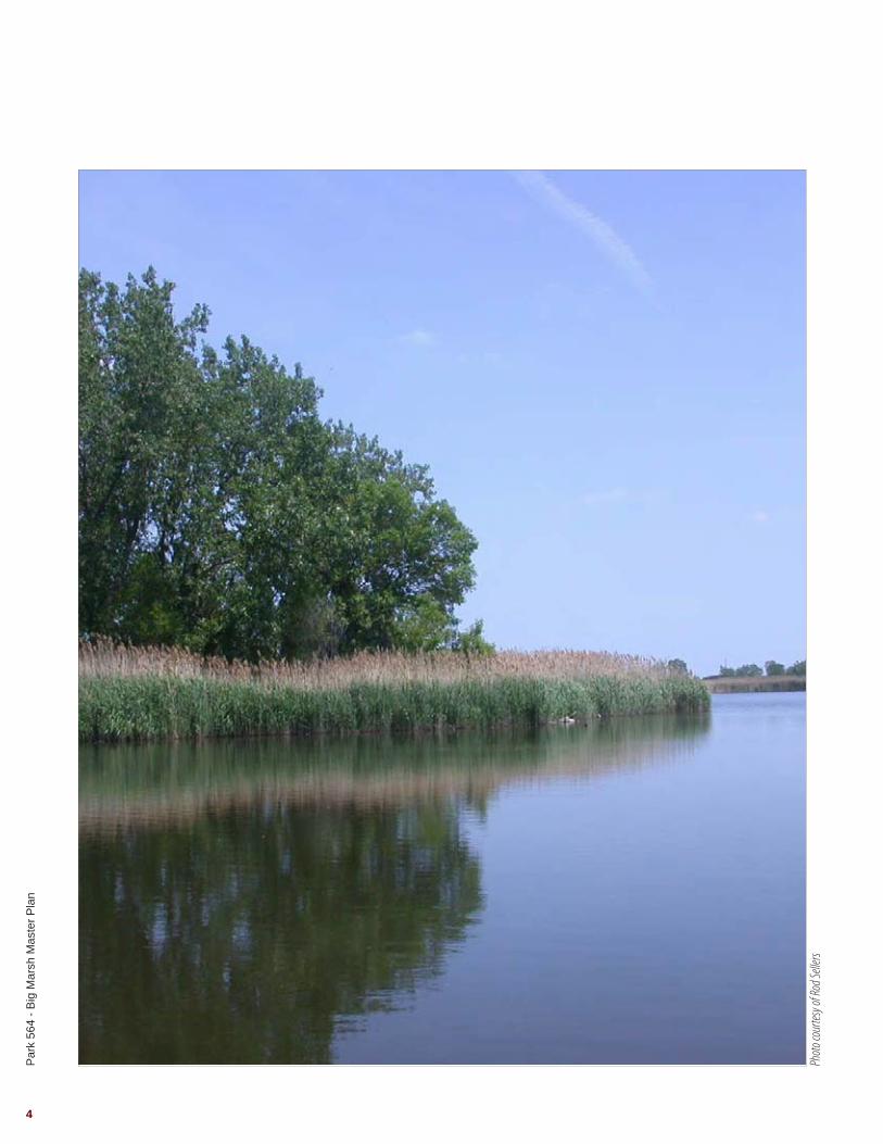
Cover photo courtesy of Rod Sellers
Hitchcock Design Group, Landscape Architect
Fujikawa Johnson Gobel Architects, Architect
Primera Engineers, Civil Engineer
O’Brien & Associates, Geotechnical Engineer
Environmental Design International Inc., Surveyor
Cardno JFNew, Natural Resources Consultant
Tetra Tech, Environmental Consultant
Stat Analysis Corporation, Environmental Consultant
Test America, Environmental Consultant
Grace Analytical Lab, Inc., Environmental Consultant
Raimonde Drilling, Environmental Consultant
International Mountain Bicycling Association, Bicycle Course Consultant
PROJECT TEAM

Par
k 56
4 - B
ig M
arsh
Mas
ter P
lan
3
5 Introduction7 Site History
11 Research & Analysis13 Project Location 17 Site Inventory35 Site Analysis
Schematic Design39 Design Program43 Lake Calumet Design Inspiration47 Design Inspiration49 Overall Plan51 Core Area Enlargement53 Bike Are Enlargement57 Restoration Plan59 Utility Diagram
63 Implementation Strategy65 Cost Summary67 Phase 169 Phase 271 Phase 373 Phase 4
Appendix Preliminary Survey Cost Opinions Limited Phase II Environmental Site Assessment Report Soil Borings
TABLE OF CONTENTS
Par
k 56
4 - B
ig M
arsh
Mas
ter P
lan
4
Photo
cour
tesy o
f Rod
Selle
rs

Par
k 56
4 - B
ig M
arsh
Mas
ter P
lan
5
INTRODUCTION
It is an exciting time for the City of Chicago, the Chicago Park District and the numerous stakeholders involved with this complex project. The Chicago Park District is working with Hitchcock Design Group and their project team in a comprehensive process that will be highly collaborative and reflective of community and stakeholder interests.
The Chicago Park District acquired Park 564 – Big Marsh from the City of Chicago in June 2011. In July 2013, The Chicago Park District applied for an Illinois Department of Natural Resources (IDNR) Open Spaces and Land Acquisition Grant (OSLAD) to aid in the funding and development of the site. The Chicago Park District outlined various eco-recreation activities to be developed at the park including but not limited to:
• Fishing• Canoeing• Hiking• Trail biking• Bird watching
Together, the team outlined a three-phase strategy:
• Research and Analysis• Schematic Design• Implementation Strategy
The focus of the Research and Analysis phase was to identify the issues and most promising opportunities that meet the goals and objectives based on the characteristics of the site, natural, physical, and cultural resources, and the interests of the Chicago Park District, project stakeholders and community members. Once the opportunities were identified, the Schematic Design illustrates the preferred approach to capital improvements. Finally, the Implementation Strategy outlines a phasing plan that assists the Chicago Park District with long range capital planning and fundraising.
Photo
cour
tesy o
f Sou
theas
t Chic
ago H
istori
cal M
useu
mPh
oto co
urtes
y of S
outhe
ast C
hicag
o Hist
orica
l Mus
eum
Par
k 56
4 - B
ig M
arsh
Mas
ter P
lan
6
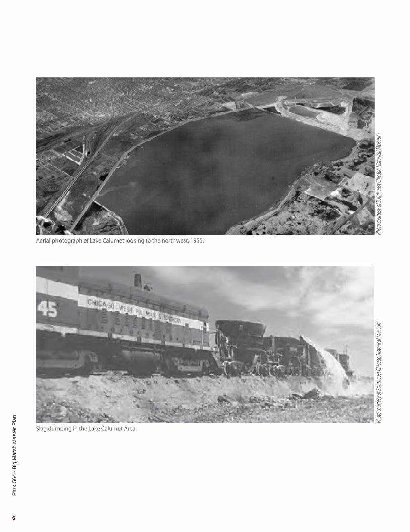
Aerial photograph of Lake Calumet looking to the northwest, 1955.
Slag dumping in the Lake Calumet Area.

Par
k 56
4 - B
ig M
arsh
Mas
ter P
lan
7
SITE HISTORY
Local HistoryThe city of Chicago Community Area, South Deering, was originally known as Irondale. In 1875, the Joseph H. Brown Iron and Steel company opened and was the areas first major industrial development. The surrounding settlement became known as Irondale. The community was renamed South Deering in 1903 after the Deering Harvester Company which later became International Harvester. South Deering is approximately 9 square miles and a population of 15,109. South Deering has the lowest population density in the city of Chicago with 1,700 residents per square mile.
Points of InterestAcme SteelAddress: 11236 South Torrence AvenueActive: 1905-2001Purpose: Coke productionPreviously known as the following companies: Acme Steel Furnace Plant, Federal Furnace, By Products Coke Corporation and Interlake Steel.
Wisconsin SteelActive: 1875-1980Address: 106th Street and Torrence AvenuePurpose: Coke production, steel making, casting and primary rolling.Previously known as the following companies: Joseph H. Brown Iron & Steel Company, Calumet Iron & Steel, South Chicago Furnace Company, Deering Harvester Company.
Paxton I&IIAddress: 11601 South Stony Island AvenueActive: 1971-1992Purpose: Landfill accepting general refuse, industrial waste and sludges.
Cluster SitesActive: Bordered by 118th and 122nd Street and Torrance and Stony Island Avenue. Purpose: Combination of four industrial sites: Alburn Incinerator, U.S. Drum II, Paxton Avenue Lagoons and Unnamed Parcel.
Park 564 - Big Marsh HistoryFrom 1830-1880 the site was primarily used for hunting and fishing. During the 1880’s the site was impacted by the development of the railroad that borders the eastern edge of the site currently owned and operated by Norfolk Southern. Beginning in 1929, an access road had been installed for the rail yard located directly north of the site at 110th street. This access road led to illegal dumping at the northeast corner of the site. Signs of this dumping have been recorded in the Phase I Environmental Site Assessment prepared by Terracon and the Phase I Environmental Site Assessment prepared by Tetra Tech.
For many years steel slag was routinely deposited along the southern end of the site by Acme Steel. In addition to the slag deposits, Acme Steel also developed a series of sand pits at the northeast corner of the site which were also used as dumping grounds until Waste Management removed the material and converted them back to sand pits. Beginning in the 1970’s the Unites States Army Corps of Engineers began dumping dredging spoils from Lake Calumet along the west side of the site.
Previous owners of the site include:
• The Woodman Family• Senator Douglas• The Carnay Family• W.S. Ingraham and H. Wisner• P. Timmonys• Acme Steel• Waste Management, Inc.• City of Chicago

Par
k 56
4 - B
ig M
arsh
Mas
ter P
lan
8

Research & Analysis

Par
k 56
4 - B
ig M
arsh
Mas
ter P
lan
10
Photo
cour
tesy o
f Rod
Selle
rs

Par
k 56
4 - B
ig M
arsh
Mas
ter P
lan
11
SummaryThe objective of the Research and Analysis phase is to identify the best opportunities for Park 564 – Big Marsh based on characteristics of the existing marketplace; the natural, physical, cultural and financial resources and the interests of stakeholders and constituents. The Chicago Park District, stakeholders and local residents have been actively engaged in the Calumet Area planning process. The findings of the Research and Analysis will guide the planning process and allow the project to make informed decisions. The following represents a summary of the key findings from the research and analysis conducted for Park 564 – Big Marsh.
Ownership and JurisdictionThe project site is currently owned by the Chicago Park District and was purchased from the City of Chicago in June of 2011. The project is included in the Millennium Reserve which was established by the State of Illinois in March of 2013. Permit agencies include the following:
• City of Chicago Department of Buildings• Army Corps of Engineers (ACOE)• Metropolitan Water Reclamation District (MWRD)• Illinois Department of Natural Resources (IDNR)• Illinois Environmental Protection Agency (IEPA)
ResourcesThere are many studies and plans that have been previously developed for the City of Chicago and The Chicago Park District that were reviewed during Research and Analysis. The following documents were reviewed:
• Park 564 Trail and Habitat Development OSLAD Grant Application, Prepared by the Chicago Park District. June, 2013
• Phase I Environmental Site Assessment for Big Marsh, Prepared by Terracon. March, 2011
• Calumet Open Space Reserve, Prepared by the City of Chicago Department of Planning and Development. December, 2005
• Calumet Area Hydrologic Master Plan, Prepared by V3 Companies. July, 2006
• Calumet Design Guidelines, Prepared by Planning Resources. February, 2004
• Calumet Area Ecological Management Strategy, Prepared by the City of Chicago Department of Environment. January, 2002
• Calumet Area Land Use Plan, Prepared by the City of Chicago Department of Planning and Development. December, 2001
• Phase I Environmental Site Assessment, Prepared by Terracon Consultants Inc. March 25,2011.
• Limited Phase II Environmental Site Assessment Project Report, Prepared by Tetra Tech Inc. February 11, 2014.
• Department of Water Management Sewer and Water Atlas
Existing Conditions InformationThe Chicago Park District, Hitchcock Design Group and representatives from their project team have conducted numerous site visits to observe the existing site conditions. The Project Team gathered GIS data from the following sources:
• City of Chicago • Cook County Assessor’s • Chicago Park District • V3 Companies• Indiana Geological Survey – Lake Rim GIS
RESEARCH & ANALYSIS

CHICAGO AND WESTERN INDIANA RR
NORF
OLK S
OUTH
ERN
RR
S STO
NY IS
LAND
AVE
E 116TH ST
S CRA
NDON
AVE
110TH ST
S CHAPPEL AVE
Source: Esri, DigitalGlobe, GeoEye, i-cubed, USDA, USGS, AEX,Getmapping, Aerogrid, IGN, IGP, swisstopo, and the GIS User Community
Par
k 56
4 - B
ig M
arsh
Mas
ter P
lan
12
Legend
NScale: 1" = 600
150’ 300’ 600’0'
Project Site
Project Limits

§̈¦I- 90
£¤20
§̈¦I- 90
£¤20£¤12
£ ¤41
§̈¦I-94
§̈¦I-94
§̈¦I-94
LAKE CALUMET
WOLF LAKE
LITTLE CALUMET RIVER
LITTLE CALUMET RIVER
Illin
ois
Indi
ana
§̈¦I- 90
§̈¦I- 65
§̈¦I- 94§̈¦I- 80
£¤6
£¤30
£¤41
£¤231
£¤12
£¤20
LAKE MICHIGAN
§̈¦I- 90
§̈¦I- 294
§̈¦I- 57
§̈¦I- 94
§̈¦I- 55
§̈¦I- 80
§̈¦I- 355
§̈¦I- 290
§̈¦I- 88
£¤6
£¤14
£¤12
£¤45
£¤41
£¤30
£¤52
£¤20
£¤34
£¤ 6
§̈¦I- 90
Par
k 56
4 - B
ig M
arsh
Mas
ter P
lan
13
PROJECT LOCATION
Study AreaThe site is located in Chicago’s Far Southeast Side community area of South Deering and is part of the 10th Aldermanic Ward.
The project site is bounded by the Norfolk Southern Railroad to the east, 116th Street and the Paxton Landfill to the south, Stony Island Avenue to the west and 110th street to the north. The site is approximately 278 acres with 98 acres of open water.
Many regionally significant and high quality natural areas are located near the project site including the following sites:
• Van Vlissigen Prairie• Indian Ridge Marsh• Hegewisch Marsh• Beaubien Woods• Eggers Woods
Local Context
Regional Context

Par
k 56
4 - B
ig M
arsh
Mas
ter P
lan
14
Aerial photograph taken in the 1930’s looking to the east with the project site in the foreground.
Calumet Transfer Station
South Deering (Irondale)
Park 564 - Big Marsh
Wisconsin SteelState Line
Generating Plant
Acme Steel
Lake Calumet

Par
k 56
4 - B
ig M
arsh
Mas
ter P
lan
15
Future Site of the Paxton Landfill, 1971
Calumet River Republic Steel
Lake Michigan
Photo
cour
tesy o
f Sou
theas
t Chic
ago H
istori
cal M
useu
m

Powderhorn Lake Forest
Preserve
WOLF LAKE
CA
LUM
ETR
IVER
LAK
E
MIC
HIG
AN
95TH STREET
100TH STREET
103RD STREET
106TH STREET
114TH STREET
Chicago Skyway
130TH STREET
126TH STREET
134TH STREET
City Limits
Bishop Ford Expressway
Illin
ois
/Ind
ian
a B
ord
er
STO
NY
ISLA
ND
AV
ENU
E
TOR
REN
CE
AV
ENU
E
LAKECALUMET
122ND STREET
AV
ENU
E O
Eggers Woods
Bu
rnh
am
Gre
enw
ay
CalumetPark
BeaubienWoods Forest
Preserve
HarborsideInternationalGolf Center
calumet area land use planCalumet Area Land Use Map
50 ACRES
0 750' 1500' 3000' 6000'
NORTHAcreage calculations are for planning purposes only. The calculations are not based on platted survey information.
Approved by the Chicago Plan CommissionFebruary 14, 2002.
Industrial
Open Space Recreation
Open Space Reclamation
Open Space Preservation
Public Open Space
Calumet Tax IncrementFinance Area
Major Roadways
Heavy Truck Route
Railroads
LEGEND
Par
k 56
4 - B
ig M
arsh
Mas
ter P
lan
16
Calumet Area Land Use Plan, 2002

Par
k 56
4 - B
ig M
arsh
Mas
ter P
lan
17
SITE INVENTORY
Park 564 - Big Marsh Land UseBig Marsh is located in a heavily industrialized community area of South Deering. In the areas surrounding the site, there is a mix of residential, industrial, public open space, open space preservation, open space recreation and open space reclamation land uses. Major land owners adjacent to the project site include the following:
• Calumet Transfer Station and In Terminal Services• Norfolk Southern Railway Corporation• Acme Steel Slag and Steel Coke Plant• Indian Ridge Marsh, City of Chicago• Lake Calumet Cluster Facilities• Paxton I&II Landfills
The Calumet Area Land Use Plan is intended to create a landscape on the Far Southeast Side of Chicago where industry and open space harmoniously coexist. In a city where large tracts of vacant industrial land are needed but scarce, the Calumet Area retains well over 1,000 acres suitable for manufacturing and other business uses. Almost 60 percent of land in Chicago that is available for industry can be found here, potentially accommodating close to 7 million square feet of new industrial space. The industrial land exists side-by-side with approximately 4,000 acres of Chicago’s most important wetlands.The land use plan examines the history of the area, its landscape and waterways, transportation assets, potential for recreation and opportunities for economic growth while protecting the natural environment. It was adopted by the Chicago Plan Commission in December 2001. (City of Chicago)

Par
k 56
4 - B
ig M
arsh
Mas
ter P
lan
18
Millennium Reserve: Calumet Core Project Area
Park 564 - Big Marsh

Par
k 56
4 - B
ig M
arsh
Mas
ter P
lan
19
SITE INVENTORY
Open Space InventoryMillennium Reserve: Calumet Core is a 220-square mile opportunity to transform a region in transition. Its goal is to catalyze innovative partnerships and action in the Calumet region that:
• Honor its cultural and industrial past;• Restore and enhance the natural ecosystems;• Support healthy and prosperous communities
and residents; and• Stimulate vigorous and sustainable economic
growth
Calumet Core initiative is built upon strong partnerships, community planning, and the work of active citizens and organizations who have sought to transform an economically-challenged industrial region into a re-envisioned community landscape that is economically, environmentally and culturally vital to the region. (Illinois Department of Natural Resources)

§̈¦I- 90
£¤20
§̈¦I- 90
£¤20£¤12
£ ¤41
§̈¦I-94
§̈¦I-94
§̈¦I-94
LAKE CALUMET
WOLF LAKE
LITTLE CALUMET RIVER
LITTLE CALUMET RIVER
PARK NO. 564
HEGEWISCH MARSH
CALUMET
AVALON
VAN VLISSINGEN
PALMER
GATELY
PARK NO. 523
MANN
OWENS
ABBOTT
TULEY
ROWAN
BESSEMER
TRUMBULL
GOLDEN GATE
KENSINGTON
RUSSELL SQUARE
COLE BROWN
BURNSIDE
WOLFE
DIXON
BRADLEY VETERANS' MEMORIAL
MERRILL
LUELLA
DOUGHERTY
PARK NO. 503
ARCADELANGLEY
CARVER
DIXON
BURNHAM GREENWAY
PINE
PULLMAN
PIETROWSKI
WESOLEK
KRAUSE
BURNHAM WOODS
BEAUBIEN WOODS
WOLF LAKE OVERLOOK
EGGERS GROVE
POWDERHORN PRAIRIE
HARBORSIDE INTERNATIONAL
GOLF CENTER
PARK NO. 576
INDIAN RIDGE MARSH
Illin
ois
Indi
ana
Par
k 56
4 - B
ig M
arsh
Mas
ter P
lan
20
Open Space Inventory
Legend
NScale: 1" =10,600’
2,650’ 5,300’ 10,600'0'
Project Limits
Open Water
Chicago Park District
Cook County Forest Preserve
Other Open Space

Par
k 56
4 - B
ig M
arsh
Mas
ter P
lan
21
SITE INVENTORY
Open Space Inventory
Existing Local Park Amenities
Calumet Open Space Reserve PlanThe Calumet Open Space Reserve Plan is a guide to the protection of 3,900 acres of natural habitat in the Calumet area. The plan highlights local wildlife and important natural resources while providing guidelines for the acquisition by public agencies and strategies for their continued evolution. (City of Chicago)
Size
(acr
es)
Arch
ery
Rang
e
Band
She
ll
Base
ball
/ So
ftbal
l;
Bask
etba
ll
Boat
Lau
nch
Cano
e La
unch
Cast
ing
Com
mun
ity
Gar
den
Cros
s Cou
ntry
Sk
iing
Dog
Frie
ndly
Fitn
ess C
ours
es
Foot
ball
/ Soc
cer
Mou
ntai
n Bi
ke
Trai
l
Mul
ti-U
se P
ath
Nat
ure
Pres
erve
Play
grou
nd
Abbott Park 23.52
Arcade Park 1.23
Bradley Park 4.11
Burnside Park 5.92
Calumet Park 198.8
Carver Park 15.71
Dixon Park 5.31
Dougherty Park 2.72
Gately Park 25.04
Golden Gate Park 5.20
Indian Ridge Marsh 145
Hegewisch Marsh 117.00
Kensington Park 3.00
Krause Park .012
Langley Park 1.01
Luella Park 1.22
Mann Park 20.00
Merrill Park 3.32
Palmer Park 40.48
Park No. 576 140.00
Pietrowski Park 0.55
Pine Park 0.24
Pullman Park 0.76
Rowan Park 17.62
Trumbull Park 18.52
Tuley Park 20.19
Van Vlissingen 139.62
Veterans’ Memorial 3.87
Wolfe Park 3.70
Michigan City
Legend
NScale: 1" = 20 miles
5 mi 10 mi 20 mi0'
Project Location
30 Minutes
60 Minutes
90 Minutes
Bike Park
30 minutes
60 minutes
90 minutes
Par
k 56
4 - B
ig M
arsh
Mas
ter P
lan
22
Drive Time
INDIANA
LAKE MICHIGAN
MICHIGAN
ILLINOIS
Plainfield Bike Park
The Garden Bike Park at Clark Park
WISCONSIN
Middleton Bike Park
Grand Rapids Bike Park
Ray’s Indoor Bike Park
The Rock Bike Park

Par
k 56
4 - B
ig M
arsh
Mas
ter P
lan
23
SITE INVENTORY
Comparable Bike Park Facilities
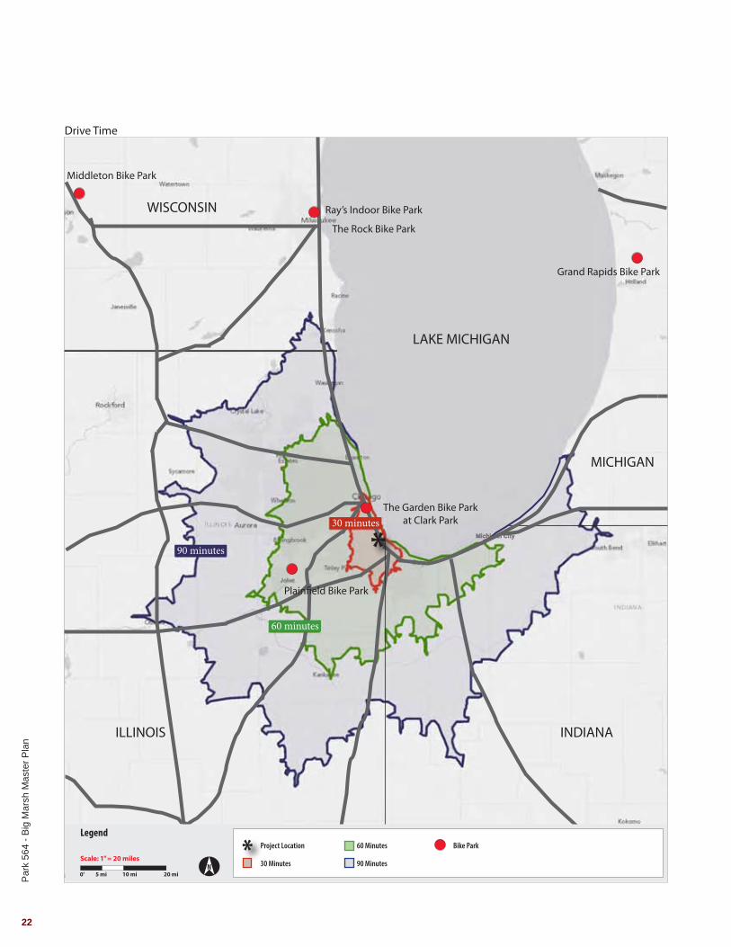
Market Analysis Approximately 9 comparable Bike Park Facilities are located in the Midwest Great Lakes Region (Illinois, Indiana Michigan, Ohio, Wisconsin). The only comprehensive Bike Park in the United States that contains the following proposed elements is Valmont Bike Park in Boulder, Colorado:
• Single Track Bike Trail• Cyclocross• Slope style Course• Pump Park• Dirt Jump Trail• Dual Slalom Course• Short Track Course • Gravity Flow Trail• Bicycle Skills Training Area
Only two mountain bike park facilities are located within 60 minutes of the site:
• The Garden Bike Park at Clark Park• Plainfield Bike Park
The Garden and the Plainfield Bike Park offer free admission and are open to both BMX and mountain bikes. Both bike parks rely on volunteers for construction and maintenance and are located on public property. Approximately 9,350,000 people live within 90 minutes of the site.
Loca
tion
Size
(acr
es)
Sing
le T
rack
Tra
il
Cycl
ocro
ss
Slop
e St
yle
Cour
se
Pum
p Pa
rk
Dirt
Jum
p Tr
ail
Dua
l Sla
lom
Co
urse
Shor
t Tra
ck
Cour
se
Gra
vity
Flo
w T
rail
Bicy
cle
Skill
s Tr
aini
ng A
rea
Plainfield Bike Park Plainfield, IL 2
The Garden Bike Park Chicago, IL 1
Boyne Highlands Ski Area Boyne, MI 100+
Stoney Creek Metro Park Detroit, MI 5
Grand Rapids Bike Park Grand Rapids, MI 6
Middleton Bike Park Madison, WI 1
Ray’s Indoor Bike Park Milwaukee, WI N/A
The Rock Bike Park Milwaukee, WI 40
Valmont Bike Park Boulder, CO 40

§̈¦I- 90
§̈¦I- 65
§̈¦I- 94§̈¦I- 80
£¤6
£¤30
£¤41
£¤231
£¤12
£¤20
LAKE MICHIGAN
§̈¦I- 90
§̈¦I- 294
§̈¦I- 57
§̈¦I- 94
§̈¦I- 55
§̈¦I- 80
§̈¦I- 355
§̈¦I- 290
§̈¦I- 88
£¤6
£¤14
£¤12
£¤45
£¤41
£¤30
£¤52
£¤20
£¤34
£¤ 6
§̈¦I- 90
Legend
NScale: 1" = 12 miles
3 mi 6 mi 12 mi0'
Project Location
Major Highways
City Limits
Major Road
Par
k 56
4 - B
ig M
arsh
Mas
ter P
lan
24
Roadways

§̈¦I- 90
£¤20
§̈¦I- 90
£¤20£¤12
£ ¤41
§̈¦I-94
§̈¦I-94
§̈¦I-94
LAKE CALUMET
WOLF LAKE
LITTLE CALUMET RIVER
LITTLE CALUMET RIVER
103RD
STON
Y ISL
AND
134TH
119TH
95TH
JEFF
ERY
127TH
126TH
123RD
111TH
WOODLAW
N
83RD
91ST
TORR
ENCE
AVE
138TH
87TH
ELLI
S
STAT
E
115TH
YATE
S
107TH
99TH
MIC
HIGA
N
JEFF
ERY
103RD
107TH
99TH
ELLI
S
ELLI
S
134TH
ELLI
S
115TH
111TH
99TH
AVEN
UE O
91ST
BRAN
DON
134TH
107TH
Illin
ois
Indi
ana
Par
k 56
4 - B
ig M
arsh
Mas
ter P
lan
25
SITE INVENTORYTransportationRoadwaysTwo main vehicular access routes to the site exist from Interstate 94, Bishop Ford, from the north and south.
NorthTravelling south on Interstate 94, take Exit 65 Stony Island. Head east on 103rd Street, turn right onto South Doty Avenue. Turn left onto South Stony Island Avenue.
Travelling south on Interstate 94, take Exit 66A 111th St. Head east on 111th Street, turn left onto South Doty Avenue. Turn right onto South Stony Island Avenue. .
South Travelling north on Interstate 94, take Exit 68B 130th Street. Head east on 130th Street, turn left onto South Torrence Avenue. Turn left onto East 122nd Street. Turn right onto South Stony Island Avenue.
Route Options
Public TransportationMetraMetra Electric (Main Line)Nearby Stations: 115th Street111th Street107th Street103rd Street
South Shore LineNearby Stations: Hegewisch
CTA RailRed lineNearby Stations: 95th Street
Buses15, Jeffery Local28, Stony Island71, 71st – South Shore106, East 103rdJ14, Jeffery Jump
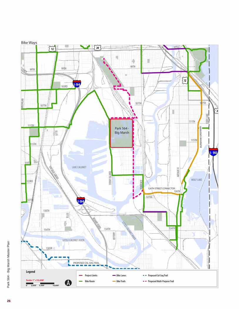
Bike WaysExisting Bike Lanes/RoutesStony island Avenue 122nd Street
Existing Multi-Purpose Trail126th Street ConnectorBurnham GreenwayMajor Taylor Trail
Legend
NScale: 1" = 10,600 miles
2,650’ 5,300’ 10,600’0'
North Access
South/Southeast Access
Exit Ramps
Park 564 -Big Marsh
65
66A
68B
§̈¦I- 90
£¤20
§̈¦I- 90
£¤20£¤12
£ ¤41
§̈¦I-94
§̈¦I-94
§̈¦I-94
LAKE CALUMET
WOLF LAKE
LITTLE CALUMET RIVER
LITTLE CALUMET RIVER
STAT
E
111TH
107TH
134TH
138TH
103RD
COTTAGE GROVE AVEN
UE O
BISHOP FORD
130TH
JEFF
ERY
99TH
STON
Y ISL
AND
TORR
ENCE
95TH
123RD
STAT
E LIN
E
YATE
S
EWING
DAN
RYAN
CHICAGO SKYWAY
83RD
115TH
MICH
IGAN
91ST
87TH
ELLIS
119TH
I57 EXPY
126TH
127TH
WOODLAWN
YATE
S
134TH
127TH
99TH99TH
111TH
ELLIS
134TH
MICH
IGAN
91ST
ELLIS
107TH
115TH
107TH
ELLIS
126TH STREET CONNECTOR
BURN
HA
M G
REEN
WAY
PROPOSED CAL-SAG TRAIL
Par
k 56
4 - B
ig M
arsh
Mas
ter P
lan
26
Bike Ways
Legend
NScale: 1" =10,600’
2,650’ 5,300’ 10,600'0'
Project Limits
Bike Route
Bike Lanes
Bike Trails
Proposed Cal-Sag Trail
Proposed Multi-Purpose Trail
Park 564 -Big Marsh

!
!
!
!
!
!
!
!
!
!
!
!
!
§̈¦I- 90
£¤20
LAKE CALUMET
WOLF LAKE
LITTLE CALUMET RIVER
LITTLE CALUMET RIVER
STAT
E
111TH
107TH
134TH
138TH
103RD
COTTAGE GROVE AVEN
UE O
BISHOP FORD
130TH
JEFF
ERY
99TH
STON
Y ISL
AND
TORR
ENCE
95TH
123RD
STAT
E LIN
E
YATE
S
EWING
DAN
RYAN
CHICAGO SKYWAY
83RD
115TH
MICH
IGAN
91ST
87TH
ELLIS
119TH
I57 EXPY
126TH
127TH
WOODLAWN
YATE
S
134TH
127TH
99TH99TH
111TH
ELLIS
134TH
MICH
IGAN
91ST
ELLIS
107TH
115TH
107TH
ELLIS
95th St.
91st St.
87th St.
83rd St.
91st St.
87th St.
Riverdale
111th St.
107th St.
103rd St.
State St.
Hegewisch
Kensington
" )30
")100
")34
" )108
")5
")87
")71
")119
" )26
")115
")14
")106
")28
")95E
")111
")15
")3 ")4
")29
")103
")95W
")15
Legend
NScale: 1" = 10,600’
2,650’ 5,300’ 10,600’ 0'
Project Limits
Bus Routes
Metra Routes
Metra Stops
Public Transportation
Par
k 56
4 - B
ig M
arsh
Mas
ter P
lan
27
Park 564 -Big Marsh

Par
k 56
4 - B
ig M
arsh
Mas
ter P
lan
28
SITE INVENTORY
Utilities and InfrastructureWater ServiceCurrently city water is not available in the immediate vicinity of the project site. The nearest available City water facilities are shown on the Department of Water Management (DWM) water atlas page p704. The atlas indicates the presence of a 16-inch diameter ‘feeder’ water main within the Stony Island Avenue right-of-way, which dead-ends roughly 400-500 feet south of 116th Street.
Based on preliminary discussions, to provide water service to the site, CPD needs to coordinate with DWM. A formal letter of request must be submitted to DWM to request a new water service extension. The following items have been discussed with DWM:
• CPD shall request if the new water extension is to be publicly owned or privately owned.
• The extension would most likely be 6” or 8” water main.
• CPD must pay for the cost of construction & design. DWM would construct the extension.
• DWM will consider the options to either design the water extension, sub out the design to a preferred engineer or allow CPD to use their own design team already assigned to this project or other.
• DWM could have the extension designed & built between 4-6 months, however they will not do any work without being paid for such work.
Sanitary ServiceCurrently city sanitary sewer service is not available in the immediate vicinity of the site. The nearest sanitary sewers are believed to be a privately owned force main located along Stony Island & 118th St. A gravity sewer is available at Stony Island & 130th Street. The City sewer atlas pages covering the site are: 37-2-18; 37-2-19; 37-2-23; and 37-2-24.
Options to consider include:
1. New connection to City sewer2. Underground pump out tanks3. Portable / temporary facilities
Stormwater ManagementExisting overall hydrologic characteristics of the project site (as well as the larger area) were assessed and summarized in the ‘Calumet Area Hydrologic Master Plan’ prepared by V3 Companies in 2006. See Structure #5 of the report. The existing drainage patterns for the site flow from the southeast to northwest towards the existing Big Marsh Main Pool. The existing drainage outlet from the site is at the southwest corner and consists of a rectangular concrete drop inlet structure with twin 30-inch diameter outlet pipes which cross underneath Stony Island Avenue and discharge into Lake Calumet.
• We have reviewed the Calumet Design Guidelines and also discussed requirements with the DWM for stormwater management in the Calumet region. We have confirmation from DWM that they will be the reviewing agency for work within the Calumet Region and specifically the Big Marsh project. It was also confirmed that the Chicago Stormwater Ordinance will be the regulatory document to follow for stormwater design.
• Assuming the developed site will either disturb 15,000 SF of area or create at least 7,500 SF of impervious area, this development will be regulated and therefore require the following:
• Rate Control Detention Storage• Volume Control• Various Best Management Practices (BMP)
• The ground water level in this area is relatively high. This design constraint will hinder detention storage underground. It is anticipated that detention will need to be accommodated by surface storage. A design option would be to utilize a large Bio-swale to provide surface detention & meet BMP requirements.
DrivewayFor access to the site a driveway permit shall be required from both CDOT & IDOT. Permitting is expected to take approximately 2-3 months.
• Typical Commercial driveway widths are 20-25 ft with 3 ft flares on each side. Over 25 ft wide requires an oversized driveway permit & variance.
• Driveways shall be minimum 8” Concrete.

Par
k 56
4 - B
ig M
arsh
Mas
ter P
lan
29
Electrical ServiceThe electrical service will be an extension of the existing ComEd service located along 116th Street near Stony Island Avenue. This 4160 volt., 3 phase underground service will extend to the new site service location next to the parking lot where a new 225KVA , 4160//208/120 volt., 3 phase pad mounted utility transformer will be provided. From there, secondary electrical distribution equipment will be provided consisting of a 120/208 volt 3 phase 600 amp distribution panel, weatherproof enclosure and meter which will provide electricity to the site. Anticipated electrical loads include 300 amps for the concession building, 30 amps of parking lot lighting and 50 amps of miscellaneous loads. For any special events, we currently cannot state the loads, as loads could be high depending on the scope and would require evaluating an entirely different approach to powering site or consider recommending temporary power.
MWRD sewer map plate 23.

NORF
OLK S
OUTH
ERN
RR
110TH ST
S STO
NY IS
LAND
AVE
E 116TH ST
Legend
NScale: 1" = 600’
150’ 300’ 600'0'
Project Limits
Floodway Areas (100yr event)
Emergent Wetland
Degraded Wet Meadow
Wet Meadow
Open Water
Par
k 56
4 - B
ig M
arsh
Mas
ter P
lan
30
Hydrology

Par
k 56
4 - B
ig M
arsh
Mas
ter P
lan
31
Hydrology The Park 564 - Big Marsh is located within the Calumet River-Frontal Lake Michigan Watershed which is a subwatershed to the Little Calumet-Galien Watershed. The watershed flows to Lake Michigan and is included in the Illinois Coastal Zone Management Program (ICMP) area. The ICMP is focused on addressing the following program areas:
• Invasive Species• Habitat, Ecosystems and Natural Area Restoration• Areas of Concern• Persistent Bio-accumulative Toxins• Sustainable Development• Non-point source• Information and Indicators• Public Access and Recreation• Economic Development
FEMA Flood Insurance Rate MapThe northwest corner of the site, approximately 33 Acres, has been designated by FEMA as a Zone A floodplain and is subject to inundation by the 1-percent-annual-chance flood event. Fill materials placed within the floodplain will need to be mitigated with measures such as compensatory storage.
WetlandsDuring onsite field observations, various wetland areas were identified. Further investigation and a Wetland Deliniation Report are recommended.
• Emergent Wetland, ~70 AcresIn areas with relatively stable climatic conditions, Emergent Wetlands maintain the same appearance year after year. In other areas, such as the prairies of the central United States, violent climatic fluctuations cause them to revert to an open water phase in some years. Emergent Wetlands are known by many names, including marsh, meadow, fen, prairie pothole, and slough. (USGS)
• Wet Meadow, ~10 AcresWet meadows are a type of marsh that commonly occurs in poorly drained areas such as shallow lake basins, low-lying farmland, and the land between shallow marshes and upland areas. For most of the year wet meadows are without standing water, though the high water table allows the soil to remain saturated. A variety of water-loving grasses, sedges, rushes, and wetland wildflowers proliferate in the highly fertile soil of wet meadows. (USEPA)
SITE INVENTORY

S STO
NY IS
LAND
AVE
E 116TH ST
110TH ST
NORF
OLK S
OUTH
ERN
RR
Legend
NScale: 1" = 5,400’
1,350’ 2,700’ 5,400'0'
Project Limits
Municipal Boundary
Park
Public Open Space
Forestry
Industrial
Open Water
Legend
NScale: 1" = 600’
150’ 300’ 600'0'
Project Limits
Open Water
Emergent Wetland
Wet Meadow
Degraded Wet Meadow
Exposed Slag Field
Wooded Upland
Old Field
Road
Par
k 56
4 - B
ig M
arsh
Mas
ter P
lan
32
Vegetative Communities

Par
k 56
4 - B
ig M
arsh
Mas
ter P
lan
33
SITE INVENTORY
Vegetative CommunitiesMultiple vegetative communities were observed on-site:
• Emergent WetlandArea: 70 AcresPlant Species Observed: Common Reed, Cottonwood
• Degraded Wet MeadowArea: 15 AcresPlant Species Observed: Common Reed, Purple Loosestrife
• Wet MeadowArea: 7 AcresPlant Species Observed: Switchgrass, Red-Rooted Spike rush, Dudley’s Rush, Panicum species
• Wooded UplandArea: 65 AcresPlant Species Observed: Buckthorn, Cottonwood, Mulberry
• Old FieldArea: 27 AcresPlant Species Observed: Buckthorn, Tall Goldenrod, Kentucky Blue Grass
• Exposed Slag FieldArea: 25 AcresPlant Species Observed: Western Ragweed, Tall Boneset, Knapweed, Buckthorn
• Open WaterArea: 70 AcresPlant Species Observed: None
Emergent Wetland
Photo
cour
tesy o
f Rod
Selle
rs
Wet Meadow
Wooded Upland
Degraded Areas

CHICAGO AND WESTERN INDIANA RR
S STONY ISLAND AVE
E 116TH ST
E
110TH ST
S
Existing Drive
Summer Sun Path
Utility Structure
Potential Limits of Earthwork
Potential Limits of Earthwork
Pote
ntia
l Mul
ti-Pu
rpos
e Tr
ail C
onne
ctio
n
Pote
ntia
l Mul
ti-Pu
rpos
e Tr
ail C
onne
ctio
n
Potential Multi-Purpose Trail Connection
NO
RFO
LK S
OU
THER
N R
R
Army Corp Dredge Spoils
Summer Winds
Construction & Automotive
Debris
Earthen Dike Between Ponds
Former Sand Pits
Lake Calumet
Paxton I Land�ll Indian RidgeMarsh
FormerSite ofAcmeSteel
Paxton II Land�ll
Calumet Transfer Station
Norfolk Southern Railway Corporation
Summer Winds
Legend
NScale: 1" = 600’
150’ 300’ 600'0'
Primary Gateway
Access Point
Potential Trail Connections
Existing Drive
Views
Dredging Spoils
Debris
Potential Limits of Earthwork
Par
k 56
4 - B
ig M
arsh
Mas
ter P
lan
34
Site Analysis

Par
k 56
4 - B
ig M
arsh
Mas
ter P
lan
35
SITE INVENTORY
Site AnalysisPedestrian AccessExisting footpaths are located throughout the site with existing pedestrian access points along the west side of the site. Three potential connections to multi-purpose trails identified in the Calumet Open Space Reserve Plan are located at the northeast, southeast and southwest corners of the site.
Vehicular AccessExisting vehicular access points to the site are located at southwest corner of the site and access is currently restricted with a gate. An existing gravel drive leads from the southwest corner of the site to an access drive separating the Paxton I and Paxton II landfills.
Site FeaturesMany unique site features are located on-site:
• Slag fields• ACOE dredging spoils• Construction and Automotive Debris• Sand pit ponds separated by a dike
ViewshedsCritical viewsheds into the site are located just north of the intersection of South Stony Island Avenue and 110th Street and throughout the site looking across the open water.

Par
k 56
4 - B
ig M
arsh
Mas
ter P
lan
36

Schematic Design

Par
k 56
4 - B
ig M
arsh
Mas
ter P
lan
38
Photo
cour
tesy o
f Rod
Selle
rs
Photograph taken present day looking to the north with the project site in the foreground.
Par
k 56
4 - B
ig M
arsh
Mas
ter P
lan
39
Convert Park 564 – Big Marsh, an existing natural area and brownfield into a public park that promotes various eco-recreation activities • Create a “bike park” modeled after Valmont Park in
Boulder, CO.• Preserve and enhance the site’s natural features.• Incorporate design elements that highlight the
industrial history of the site and area.• Include additional eco-recreation activities such
as trails, boat launch, tree-top adventure course, archery, etc.
Eco-recreation is the mutually beneficial relationship between responsible leisure activities and the natural environment. It is about uniting conservation, local culture, and sustainably developed recreational facilities. This means that those who implement and participate in eco-recreation should follow the following: • Minimize negative aspects of conventional
recreation.• Enhance local culture.• Commit to conservation, protection and
enhancement of nature. The following Eco-recreation activities are proposed for Big Marsh: • Trails• Non-motorized boat launch• Treetop Adventure Course• Canoeing• Kayaking• Archery• Fishing• Bird Watching
Create a bike Park modeled after Valmont with the following activities:
• Small and Large Pump Park• Chunk Trail• Dirt Jump Trail• Gravity Flow Trail• Slope Style Course• Dual Slalom Course• Short Track Course• Single Track with Technical Features• Cyclocross• Bicycle Skills Training Area
Architecture Program
• Concessions, Restrooms, Maintenance,Community Room and Office
• Follow CPD standards where possible• Modular and expandable• Incorporate design elements that highlight the
industrial history of the site and area• Simple, Inexpensive and Durable
DESIGN PROGRAM

ArcheryPar
k 56
4 - B
ig M
arsh
Mas
ter P
lan
40
Trails
Access to water
Treetop adventure course Tot track
Boardwalk
Overlook
Fishing stations
Playground
Observation tower

Par
k 56
4 - B
ig M
arsh
Mas
ter P
lan
41
Dirt jump trailWinter activities
Dual slalom course
Gravity flow trail
Chunk trail (cyclocross course)Bicycle skills training area

Par
k 56
4 - B
ig M
arsh
Mas
ter P
lan
42
Hegewisch Marsh
Par
k 56
4 - B
ig M
arsh
Mas
ter P
lan
43
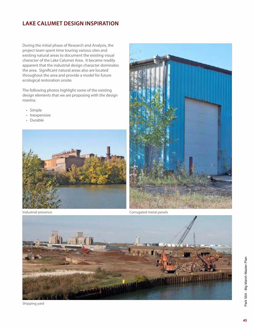
LAKE CALUMET DESIGN INSPIRATION
Shipping yard
Corrugated metal panelsIndustrial presence
During the initial phase of Research and Analysis, the project team spent time touring various sites and existing natural areas to document the existing visual character of the Lake Calumet Area. It became readily apparent that the industrial design character dominates the area. Significant natural areas also are located throughout the area and provide a model for future ecological restoration onsite.
The following photos highlight some of the existing design elements that we are proposing with the design mantra:
• Simple• Inexpensive• Durable

Par
k 56
4 - B
ig M
arsh
Mas
ter P
lan
44
Industrial factory
Woodland trails
Bridge truss Shipping remnants
Abandoned factories

Par
k 56
4 - B
ig M
arsh
Mas
ter P
lan
45
Shipping yard
Abandoned concrete structures
Concrete blocks Slag remnants
Lift bridge

Par
k 56
4 - B
ig M
arsh
Mas
ter P
lan
46
Concessions building
Boardwalk
Reclaimed wood
Asymmetric roof design
Lakefront revetment
Garage doors
Par
k 56
4 - B
ig M
arsh
Mas
ter P
lan
47
Shipping container storage
Corrugated metal tunnels
Corrugated metal panels
Exposed rebar slots
Stacked shipping containers
Shipping container walls
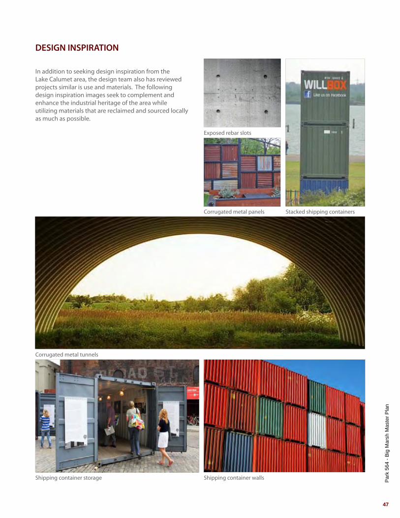
DESIGN INSPIRATION
In addition to seeking design inspiration from the Lake Calumet area, the design team also has reviewed projects similar is use and materials. The following design inspiration images seek to complement and enhance the industrial heritage of the area while utilizing materials that are reclaimed and sourced locally as much as possible.

Par
k 56
4 - B
ig M
arsh
Mas
ter P
lan
48
Stony
Islan
d Ave
nue
Norfo
lk So
uthern
RR
1
1
3 3
4
7
9
8
8
8
9
10
12
11
1113
14
14
14
14
14
11
12 12
5
6
6
6
22
2
LegendN
Scale: 1" = 500
125’ 250’ 500’0'
Parking lotOverflow parkingPicnic Grove/Permit Area
Bike ParkFlex SpaceFishing/Canoe Access
Fishing/OverlookBoardwalkMultipurpose Trail
Observation TowerSingle Track with Technical Features
Future Trail ConnectionBelgian StairsNatural Area Restoration
1.
2.
3.
4.
5.
6.
7.
8.
9.
10.
11.
12.
13.
14.
Par
k 56
4 - B
ig M
arsh
Mas
ter P
lan
49
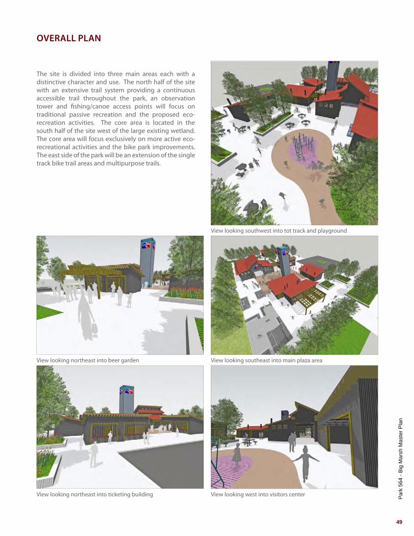
The site is divided into three main areas each with a distinctive character and use. The north half of the site with an extensive trail system providing a continuous accessible trail throughout the park, an observation tower and fishing/canoe access points will focus on traditional passive recreation and the proposed eco-recreation activities. The core area is located in the south half of the site west of the large existing wetland. The core area will focus exclusively on more active eco-recreational activities and the bike park improvements. The east side of the park will be an extension of the single track bike trail areas and multipurpose trails.
OVERALL PLAN
View looking northeast into ticketing building View looking west into visitors center
View looking southeast into main plaza areaView looking northeast into beer garden
View looking southwest into tot track and playground

Par
k 56
4 - B
ig M
arsh
Mas
ter P
lan
50
LegendN
Scale: 1" = 100
25’ 50’ 100’0'
Parking lotDrop-OffAlternative Event SpaceConcessions Building
Outdoor SeatingTicket BuildingsMerchandise BuildingMaintenance Buildings
Visitors CenterTot Track & PlaygroundVertical Sign Feature Street Elements
Flex Space Bike PlazaFishing/Canoe AccessMultipurpose Trail
Dirt TrailCrushed Stone TrailSmall Pump ParkLarge Pump Park
Treetop Adventure CoursePicnic Grove/Permit AreaNatural Area Restoration
1.
2.
3.
4.
1
2
3
1
15
12
7
8
9
13
14
12
10
11
12
12
16
17
18
19
20
21
21
22
23
23
23
18
17
17
4
6
6
5
5.
6.
7.
8.
9.
10.
11.
12.
13.
14.
15.
16.
17.
18.
19.
20.
21.
22.
23.

Par
k 56
4 - B
ig M
arsh
Mas
ter P
lan
51
ParkingThe main parking lot will consist of a gravel lot with concrete curbs at vehicular intersections and concrete wheel stops to delineate parking spaces. In total, there are 236 parking spaces provided for in the North and South parking lots. Additional overflow parking will be available west of the main parking lot and along Stony Island Avenue.
Concession Building with Outdoor DiningTwo concession facilities will be located onsite. Both concession facilities will share storage spaces and a common kitchen. One concession stand will serve typical concession stand items and the other will serve hot food and alcohol sales with large covered patio.
TicketingTwo separate ticketing building will be located in the plaza and will serve the Tree top Adventure Course and the Bike Park. The ticketing building for the Tree Top Adventure Course will be funded and constructed by the vendor.
Merchandise BuildingThe Merchandise Building will provide a location for bike rentals, apparel sales and miscellaneous bike parts for the bike park users.
Maintenance BuildingThe Maintenance Facility will provide a location for the storage of materials and equipment related to the maintenance of the bike park.
Visitors CenterThe Visitors Center will be the largest building in the plaza and contain the following program elements: bathrooms, conference room, offices, small kitchen and an information kiosk.
Tot Track with PlaygroundCreated for the youngest riders, the tot track is located adjacent to a play structure. The tot track allows parent to watch their children in a controlled area.
Vertical Sign FeatureA large vertical sign feature is located in the plaza and is constructed from shipping containers offering park visitors a visual point of reference while onsite.
Street ElementsStyle street elements will be located in the plaza and along the flex space to provide riders an alternative experience to the more prevalent dirt features.
CORE AREA ENLARGEMENT
Fishing and Canoe AccessFishing and Canoe Access will be provided at multiple locations throughout the park. These locations will either be designed as a boardwalk / pier or as naturalized stone outcropping.
Alternative Event SpaceThe entry drive between the west and east entrance to the parking lot can be utilized as an alternative event space for large display and semi-trailers. Both the north and south parking lot can be utilized while this space is in use.
Flex SpaceThe Flex Space is designed to hold large scale festival and tents in support of the bike park. At the east end of the flex space a stage can be erected in the bike park plaza facing the southwest. The Flex Space covers approximately 2 acres.
Treetop Adventure CourseTreetop Adventure Course allows participants to explore the park from an otherwise unobtainable vantage point while navigating through the treetops using zip lines, obstacles and tarzan swings. Participants will purchase tickets at the northern most ticketing building and proceed to the start of the course directly east of the pier. The Treetop Adventure Course will proceed clockwise around the main bike park and finish southeast of the maintenance facility.
Multipurpose TrailThe Multipurpose Trail will be 10’ wide asphalt trail, accommodate a wide range of users and meet ADA Accessibility Standards. Approximately 3.5 miles of trail are planned and will provide a continuous loop around the site. The multipurpose trail will also be able to accommodate light maintenance vehicles as well as emergency vehicles.
Small Pump ParkA short, low amplitude pump park allows for riders to progress and learn the kinesthetic process of riding a bicycle off road. The small pump park offers a series of rollers with receiving berms at either end giving riders a chance to reverse direction or catch air.
Large Pump ParkThe large pump park offers advanced riders the ability to have a mountain bike slope style experience with BMX street elements in a relatively flat zone. Dubbed progress parks, these new pump park styles incorporate traditional dirt features with wooden elements such as ramps, rollers, quarter pipes and dishes.

Par
k 56
4 - B
ig M
arsh
Mas
ter P
lan
52
1
2
3
45
6
7
8
9
13
10
10
10
11
11
14
12
15
16
16
15
15
15
15
15
15
15
LegendN
Scale: 1" = 100
25’ 50’ 100’0'
Bike Plaza Chunk TrailDirt Jump Trail
Gravity Flow TrailSlope Style CourseDual Slalom Course
Shelter Fly Over/Under35’ Tall Hill
Shipping Container Shipping Container Retaining Walls
RampMultipurpose TrailCrushed Stone Trail
Dirt TrailNatural Area Restoration
1.
2.
3.
4.
5.
6.
7.
8.
9.
10.
11.
12.
13.
14.
15.
16.
Par
k 56
4 - B
ig M
arsh
Mas
ter P
lan
53
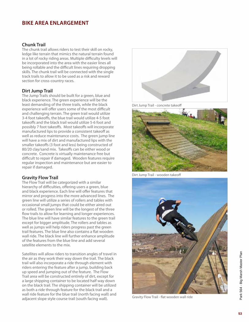
Chunk TrailThe chunk trail allows riders to test their skill on rocky, ledge like terrain that mimics the natural terrain found in a lot of rocky riding areas. Multiple difficulty levels will be incorporated into the area with the easier lines all being rollable and the difficult lines requiring dropping skills. The chunk trail will be connected with the single track trails to allow it to be used as a risk and reward section for cross-country races.
Dirt Jump TrailThe Jump Trails should be built for a green, blue and black experience. The green experience will be the least demanding of the three trails, while the black experience will offer users some of the most difficult and challenging terrain. The green trail would utilize 3-4 foot takeoffs, the blue trail would utilize 4-5 foot takeoffs and the black trail would utilize 5-6 foot and possibly 7 foot takeoffs. Most takeoffs will incorporate manufactured lips to provide a consistent takeoff as well as reduce maintenance costs. The green jump line will have a mix of dirt and manufactured lips with the smaller takeoffs (3 foot and less) being constructed of 80/20 clay/sand mix. Takeoffs can be either wood or concrete. Concrete is virtually maintenance free but difficult to repair if damaged. Wooden features require regular inspection and maintenance but are easier to repair if damaged.
Gravity Flow TrailThe Flow Trail will be categorized with a similar hierarchy of difficulties, offering users a green, blue and black experience. Each line will offer features that mirror and progress into the more advanced lines. The green line will utilize a series of rollers and tables with occasional small jumps that could be either aired out or rolled. The green line will be the longest of the three flow trails to allow for learning and longer experiences. The blue line will have similar features to the green trail except for bigger amplitude. The rollers and tables as well as jumps will help riders progress past the green trail features. The blue line also contains a flat wooden wall ride. The black line will further enhance amplitude of the features from the blue line and add several satellite elements to the mix.
Satellites will allow riders to transition angles of travel in the air as they work their way down the trail. The black trail will also incorporate a ride through element with riders entering the feature after a jump, building back up speed and jumping out of the feature. The Flow Trail area will be constructed entirely of dirt, except for a large shipping container to be located half way down on the black trail. The shipping container will be utilized as both a ride through feature for the black trail and a wall ride feature for the blue trail (north facing wall) and adjacent slope style course trail (south facing wall).
BIKE AREA ENLARGEMENT
Dirt Jump Trail - concrete takeoff
Dirt Jump Trail - wooden takeoff
Gravity Flow Trail - flat wooden wall ride

Par
k 56
4 - B
ig M
arsh
Mas
ter P
lan
54
Slope Style Course - cantilevered container cannon
Slope Style Course - whale tale or sputnik
Dual Slalom Course - example course
Slope Style Course - curved wall ride

Par
k 56
4 - B
ig M
arsh
Mas
ter P
lan
55
Slope Style CourseThe slope style course will cater to the advanced rider. A rider should have progressed from the jump trails and through the flow trails before riding the slope style course. The slope style course will have a single filtered entrance followed by two options for riders to go left or right at manufactured takeoffs. The filtered entrance will act as a qualifier for all riders entering the course. A narrow, funnel shaped ramp will place riders onto a concave ramp before dropping or airing onto a dirt receiver transition. Riders opting left will enter the easier of the two slope style courses. This will feature dirt berms, opposing curved and flat wooden wall rides, cantilevered container cannon with a dirt receiver, and finally a step on/step off feature onto the backstop container. The step on/step off will be a drop to an angled receiver that is shared with the finish to the more difficult line. Riders heading to the right after the filter will enter the more difficult slope style course. The first feature they’ll encounter will be a whale tail or dish. Once exiting the dish they will encounter two manufactured take offs; a 7 foot ramp followed by an 8 foot ramp. The final feature will be a quarter pipe up against the container backstop where riders could opt for a traditional BMX style quarter pipe finish or hip jump out to an angled receiver. The flat wall ride on the easier slope style course will utilize the southern wall of the container that is used on the flow trails. The final backstop container will be a brace to support the step on/step off feature, the quarter pipe and the angled dirt receiver/cambered transition. All containers used should be modified with decking on the inside and/or outside, supports for loads they’ll receive and holes to allow light in.
Dual Slalom CourseA traditional dual slalom course will be incorporated with a permanent BMX style start ramp. This will allow riders to practice heats out of competitions with an actual roll in.
Single Track with Technical FeaturesThe single track adjacent to the gravity area will have multiple prefabricated lines that will attract users for their uniqueness and begin to create both skills and fitness. Multiple wooden features with optional ride arounds will be: rollers, double rollers, triple rollers, snake ladders, zig zags and steel I-Beam skinnys. The single track located on the east side of the site will have natural terrain challenges that enhance the natural topography of that location. Rock and log overs, drops, balance challenges and rock gardens will improve the
further away feel of this area. These challenges will be oriented so as to be used as risk/reward passing sections and technical sections for XC Eliminator or XC short track events. All the single track trails in the park will have intersections and loop options to maximize the mileage for an event or a ride.
Cyclocross Course and ElementsThe cyclocross course will utilize a mixture of the single track, multi-use trails, recreation paths and naturalized areas in the park to create challenging courses. Permanent features such as Belgian steps, sand pits and logs or barriers will be located in areas that can be utilized during various parts of the year. One set of stairs will be located in the pump park compound and another will access the flow trail, slope style and dual slalom start pads. Locations here allow for a run up followed by opportunities for technical or single track descents. The permanent sand pits allow riders to practice on loose, unconsolidated treads.
Single Track - technical features
Steel I-beam skinnys
Zig zags
Snake ladders
Triple rollers
Double rollers
Rollers
Stony
Islan
d Ave
nue
Par
k 56
4 - B
ig M
arsh
Mas
ter P
lan
56
LegendN
Scale: 1" = 100
25’ 50’ 100’0'
Overland Flow RouteWater Improvement RouteConnect Existing Ponds
Water Control Structure Route
Wildlife Habitat ImprovementsWater Quality Improvements
Vegetative Community Improvements
1
1
1
1
2
2
3
3
4
4
5 6
6
6
6
1
2
5
3
4
6
6
6
6
7
6
1
1
2
2
1
3
3
3
4
4
4
2
2
4
2
3
# #
#

Par
k 56
4 - B
ig M
arsh
Mas
ter P
lan
57
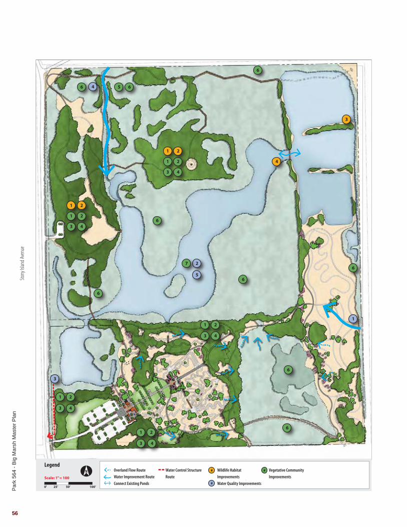
Ecological restoration onsite will focus on three categories: wildlife habitat improvements, vegetative community improvements and water quality improvements. All three categories are interrelated and necessary for the long term ecological and environmental health of Big Marsh.
Wildlife Habitat Improvements1. Save select trees, tree trunks, limbs and fallen trees which will be used as wildlife habitat.2. Install structures to improve wildlife habitat such as artificial nesting structures and bat houses. 3. Remove section of peninsula to better accommodate bird habitats and connect isolated ponds to create deep water pockets for fish habitat so they can overwinter.4. Connect isolated ponds to create deep water pockets for fish habitats. Vegetative Community Improvements1. Selectively remove non-native trees throughout the site.2. Prune and/or remove hazardous trees throughout the site.3. Selectively remove non-native understory plant material throughout the site.4. Enhance woodland areas with a diverse mix of trees and understory plant material.5. Remove all visible debris and litter.6. Restore and enhance emergent wetlands, degraded wet meadow and wet meadow areas.7. Establish hemi-marsh conditions by controlling the ponds water level and fish populations.
Water Quality Improvements1. Improve the quality of water entering the site from the former Acme Coke plant through the creation of constructed wetlands and other green infrastructure to treat the water before it enters the pond. 2. Conduct a detailed surface and groundwater investigation of the ponds at Big Marsh. 3. Install the proposed water control structure connecting Big Marsh to Lake Calumet.4. Restore the stream and adjacent wetland to improve the quality of water entering the site from the Norfolk Southern property. 5. Establish management plan for long term management.
RESTORATION PLAN
Prairie restoration
Natural area restoration (Buckthorn Removal)
Natural area restoration (Phragmites Control)

Par
k 56
4 - B
ig M
arsh
Mas
ter P
lan
58
LegendN
Scale: 1" = 500
125’ 250’ 500’0'
Proposed Electrical Connection at 116th Street
Existing Electrical Along 116th Street
Proposed Transformer
Proposed 8” Water Main and 5’ Diameter Vault
Proposed Irrigation System
Proposed 4,000 Gallon Sanitary Holding Tank
Stony
Islan
d Ave
nue
116th Street
Par
k 56
4 - B
ig M
arsh
Mas
ter P
lan
59
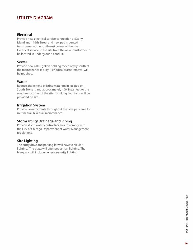
ElectricalProvide new electrical service connection at Stony Island and 116th Street and new pad mounted transformer at the southwest corner of the site. Electrical service to the site from the new transformer to be located in underground conduit.
SewerProvide new 4,000 gallon holding tack directly south of the maintenance facility. Periodical waste removal will be required.
WaterReduce and extend existing water main located on South Stony Island approximately 400 linear feet to the southwest corner of the site. Drinking Fountains will be provided on site.
Irrigation SystemProvide lawn hydrants throughout the bike park area for routine trail bike trail maintenance.
Storm Utility Drainage and PipingProvide storm water control facilities to comply with the City of Chicago Department of Water Management regulations.
Site LightingThe entry drive and parking lot will have vehicular lighting. The plaza will offer pedestrian lighting. The bike park will include general security lighting.
UTILITY DIAGRAM

Par
k 56
4 - B
ig M
arsh
Mas
ter P
lan
60

Implementation Strategy

Par
k 56
4 - B
ig M
arsh
Mas
ter P
lan
62
Graffiti Art Sponsored events
Advertising
Programs
Logos

Par
k 56
4 - B
ig M
arsh
Mas
ter P
lan
63
BrandingDeveloping a strong visual identity and then applying it through architecture and a comprehensive signage program including gateway markers, way-finding signage, directional signage and other physical improvements will establish an image for Big Marsh as a destination and draw people to the area. The same visual identity can then be used to develop a comprehensive marketing campaign to promote the park and special events.
The images on the left are a small sampling of various BMX, Mountain Biking and affiliated company brands.
Organizational Recommendations• Coordinate funding, planning and implementation
with other City Departments and Agencies.• Dedicate full time staff to run the daily operation
of the facility.• Partner with the future “Friends of Big Marsh” to
coordinate volunteer and fundraising events.• Establish proactive and coordinated relationships
with external agencies and organizations. Identify potential new partners and develop agreements and letters of understanding with partners as necessary.
• Encourage joint ventures and partnerships with recreation program providers to provide new programs in the park.
Funding Recommendations• Encourage joint ventures and partnerships with
recreation program providers to provide new programs in the park.
• Continue to actively pursue grants donations and other funding sources for capital improvements, maintenance and park programs.
• Leverage financial resources by coordinating funding with other agencies and grant programs.
• Identify and pursue potential sponsorship opportunities.
• Consider park fees for users or parking.• Annually review user fees to confirm true costs
and rate of return.• Expand revenue enhancement efforts through
partnerships, sponsorships, marketing and facility rentals.
• Analyze special event costs and develop partnership agreements to pay for the direct costs of the events.
Public Relations Recommendations• Regularly communicate with the public regarding
planned improvements, construction activities and promotional events.
• Develop a brand strategy that compliments and supports the Chicago Park District brand and other industry stakeholders.
• Create a park website, social media campaign and other communication venues.
• Design and create promotional materials that increase the visibility of the park.
Maintenance & Operations Recommendations• Create performance standards and train staff
in best-management practices for operations, maintenance and management of all bike park improvements.
• Develop an annual process to review maintenance priorities, identify annual projects and improvements to be completed.
• Develop life cycle management plan for structures and grounds
• Invest in training for staff to understand maintenance standards, performance measures and tracking, life cycle maintenance and volunteer management.
• Establish work plans for staff along with expected results for each maintenance zone and staff member.
IMPLEMENTATION STRATEGY

Par
k 56
4 - B
ig M
arsh
Mas
ter P
lan
64
Phase I$4,150,000
Phase IV$2,000,000
Phase II$6,680,000
Phase III$4,600,000

Par
k 56
4 - B
ig M
arsh
Mas
ter P
lan
65
To create the maximum initial impact, Phase I is comprised mainly of single track mountain biking improvements due to their relatively low cost and easy installation but also because single track mountain biking is what regional mountain bike riders are most familiar with. During Phase I, the importation of earthwork materials can begin and continue throughout the Phase I construction and subsequent opening. This will allow CPD ample time to acquire the necessary materials from available sources.
After Phase II and III can begin as phasing becomes available and fresh earthwork has been supplied to the site. Phase IV can occur at any time as funding becomes available.
COST SUMMARY
Phase I $4,150,000Phase II $6,680,000Phase III $4,600,000Phase IV $2,000,000
Total $17,430,000
Funding SourcesThe Chicago Park District in April of 2014 received an Open Space and Land Acquisition Grant for the Illinois Department of Natural Resources for $900,000. The grant requires the Chicago Park District to provide a $900,000 match for the grant funding. Private donations will also be solicited to aid in funding for the park improvements.
Stony
Islan
d Ave
nue
Par
k 56
4 - B
ig M
arsh
Mas
ter P
lan
66
LegendN
Scale: 1" = 100
25’ 50’ 100’0'
Entry DriveNorth Parking LotDrop-Off
Maintenance AreaCanoe/Fishing AccessFlex Space
Small Pump ParkLarge Pump ParkBike Plaza
Chunk TrailSingle Track with Technical Features
Treetop Adventure Course-Phase 1Jump Lines
Multipurpose TrailSite Remediation
1.
2.
3.
4.
5.
6.
7.
8.
9.
10.
11.
12.
13.
1
23
4
5
6
7
8
9
10 13
11
12
11
14
15
15
14.
15.

Par
k 56
4 - B
ig M
arsh
Mas
ter P
lan
67
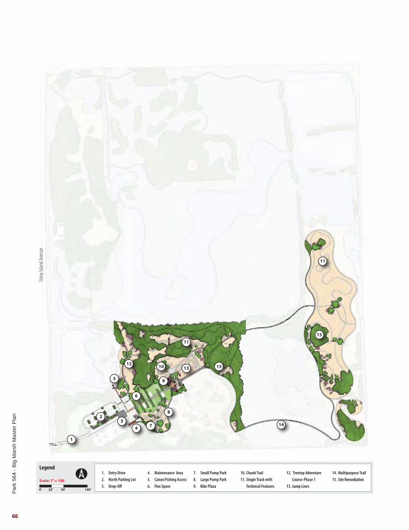
Work includes the following items:
• Site clearing and demolition• Site remediation• Entry drive with new driveway off Stony Island Avenue• North parking lot• Drop-off• Entry Plaza
- Shipping container vertical plaza sign - Play structure with surfacing - Tot track
• Maintenance area with one 32x16 maintenance / storage building and gate• Non-motorized boat launch / fishing access• Flex space• Bike park elements
- Small pump park - Large pump park - Chunk trail - Single track with technical features - Jump lines - Belgium stairs - Cyclocross course
• Bike plaza with shipping containers, stairs and railings• Fly over / under (box culvert tunnel)• Multipurpose trails, dirt trails and crushed stone trails• Landscape improvements and natural area restoration• Signage• Site furniture• Coordination of treetop adventure course phase 1• Utility infrastructure including electrical service, water service and sewer
holding tank
Total - $4,150,000
PHASE I
Par
k 56
4 - B
ig M
arsh
Mas
ter P
lan
68
Stony
Islan
d Ave
nue
LegendN
Scale: 1" = 100
25’ 50’ 100’0'
Overflow ParkingSouth Parking LotPlaza
Grinding ElementsPicnic Grove/Permit AreaShelter
Flow TrailSlope StyleDual Slalom
Crushed Stone TrailTreetop Adventure Course-Phase2
Multipurpose TrailSite Remediation
1.
2.
3.
4.
5.
6.
7.
8.
9.
10.
11.
12.
13.
1
2
3
4
5 5
6
7
8 9
12
13
10
11

Par
k 56
4 - B
ig M
arsh
Mas
ter P
lan
69
PHASE II
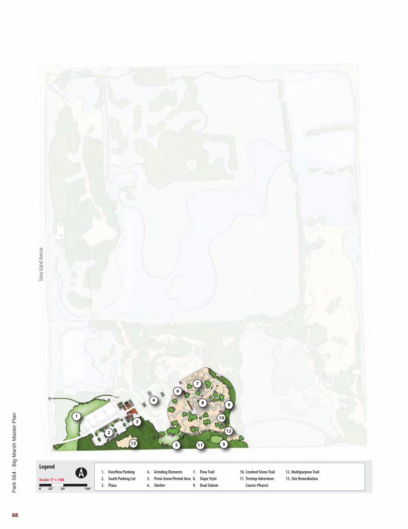
Work includes the following items:
• Site clearing and demolition• Site remediation• South parking lot• Overflow parking• Entry Plaza
- Visitors center - Outdoor seating building - One ticketing building - Merchandise building - Concession building - One 32x16 maintenance / storage building
• Flex space grinding elements• Bike park elements
- Flow trail - Slope style - Dual Slalom
• Multipurpose trails, dirt trails and crushed stone trails• Landscape improvements and natural area restoration• Signage• Site furniture• Coordination of treetop adventure course phase 2• Utility infrastructure including water service and storm service • Picnic groves / permit area with park shelters
Total - $6,680,000
Par
k 56
4 - B
ig M
arsh
Mas
ter P
lan
70
LegendN
Scale: 1" = 100
25’ 50’ 100’0'
Multipurpose Trail BoardwalkParking Lot
Canoe/Fishing AccessObservation TowerFishing Access
Crushed Stone Trail
1.
2.
3.
4.
5.
6.
7.
Stony
Islan
d Ave
nue
2
2
2
2 2
2
2
2
43
1
17
7
7
1
1
7
5
6
11

Par
k 56
4 - B
ig M
arsh
Mas
ter P
lan
71
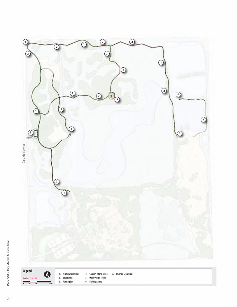
Work includes the following items:
• Site clearing and demolition• Small parking lot located directly off of Stony
Island Avenue• Non-motorized boat launch / fishing access• Multipurpose trails, dirt trails and crushed stone
trails• Observation tower
Total - $4,600,000
PHASE III

Par
k 56
4 - B
ig M
arsh
Mas
ter P
lan
72
LegendN
Scale: 1" = 100
25’ 50’ 100’0'
Woodland RestorationWet Meadow RestorationNative Planting Restoration
Proposed Wetland ShelfDegraded Wet Meadow RestorationEmergent Wet Meadow Restoration
Water Control Structure
1.
2.
3.
4.
5.
6.
7.
Stony
Islan
d Ave
nue
1
2
5
5
6
6
6
66
6
3
4 4
4
4
7
4
1
1
1
3
3

Par
k 56
4 - B
ig M
arsh
Mas
ter P
lan
73
Work includes the following items:
• Site clearing and demolition• Invasive species removal• Wetland enhancement and creation• Upland prairie enhancement and creation• Additional landscape improvements• Water control structure
Total - $2,000,000
PHASE IV

180 North Wacker Drive, Suite 003Chicago, Illinois 60606
T 312.634.2100www.hitchcockdesigngroup.com
Planning and Landscape Architecture


