1
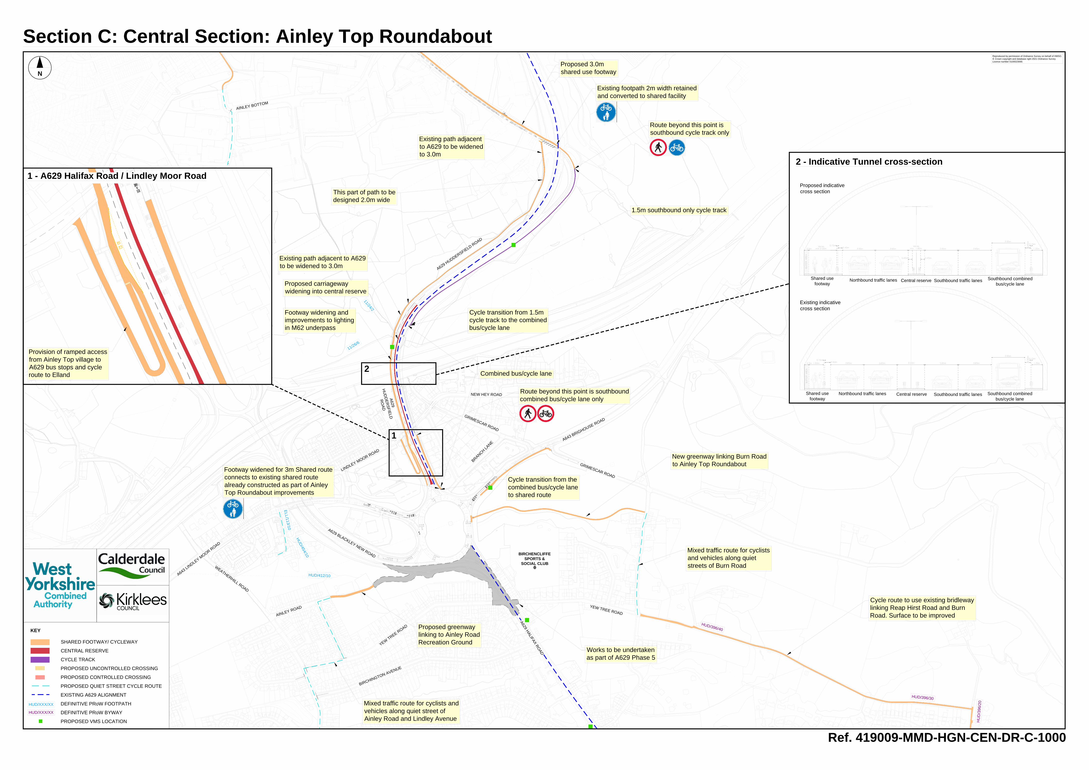
SHARED FOOTWAY/ CYCLEWAY CENTRAL RESERVE CYCLE TRACK PROPOSED UNCONTROLLED CROSSING PROPOSED CONTROLLED CROSSING PROPOSED QUIET STREET CYCLE ROUTE EXISTING A629 ALIGNMENT DEFINITIVE PRoW FOOTPATH DEFINITIVE PRoW BYWAY PROPOSED VMS LOCATION KEY HUD/XXX/XX HUD/XXX/XX BIRCHENCLIFFE SPORTS & SOCIAL CLUB 11/26/6 1 HUD/412/10 11/24/2 ELL/113/10 HUD/454/10 HUD/396/30 HUD/396/40 HUD/396/20 A629 HALIFAX ROAD YEW TREE ROAD GRIMESCAR ROAD A643 BRIGHOUSE ROAD NEW HEY ROAD A643 LINDLEY MOOR ROAD BIRCHINGTON AVENUE YEW TREE ROAD AINLEY ROAD A629 BLACKLEY NEW ROAD A629 HUDDERSFIELD ROAD LINDLEY MOOR ROAD AINLEY BOTTOM A629 HUDDERSFIELD ROAD BRANCH LANE GRIMESCAR ROAD WEATHERHILL ROAD Reproduced by permission of Ordnance Survey on behalf of HMSO. © Crown copyright and database right 2021 Ordnance Survey Licence number 0100023069. Ref. 419009-MMD-HGN-CEN-DR-C-1000 Proposed 3.0m shared use footway N Section C: Central Section: Ainley Top Roundabout 1 - A629 Halifax Road / Lindley Moor Road 1 Footway widening and improvements to lighting in M62 underpass Proposed greenway linking to Ainley Road Recreation Ground Mixed traffic route for cyclists and vehicles along quiet street of Ainley Road and Lindley Avenue Cycle route to use existing bridleway linking Reap Hirst Road and Burn Road. Surface to be improved 2 - Indicative Tunnel cross-section 2 Shared use footway Northbound traffic lanes Central reserve Southbound traffic lanes Shared use footway Northbound traffic lanes Central reserve Southbound combined bus/cycle lane Southbound traffic lanes Proposed indicative cross section Existing indicative cross section Existing path adjacent to A629 to be widened to 3.0m Existing path adjacent to A629 to be widened to 3.0m Works to be undertaken as part of A629 Phase 5 New greenway linking Burn Road to Ainley Top Roundabout Mixed traffic route for cyclists and vehicles along quiet streets of Burn Road 1.5m southbound only cycle track Cycle transition from 1.5m cycle track to the combined bus/cycle lane Combined bus/cycle lane Cycle transition from the combined bus/cycle lane to shared route Existing footpath 2m width retained and converted to shared facility Route beyond this point is southbound cycle track only Footway widened for 3m Shared route connects to existing shared route already constructed as part of Ainley Top Roundabout improvements Route beyond this point is southbound combined bus/cycle lane only Provision of ramped access from Ainley Top village to A629 bus stops and cycle route to Elland Southbound combined bus/cycle lane This part of path to be designed 2.0m wide Proposed carriageway widening into central reserve