ideaFest: Interdisciplinary Journal of Creative Works and Research from Humboldt State University Volume 1 ideaFest: Interdisciplinary Journal of Creative Works and Research om Humboldt State University Article 4 2016 Sedimentation Risk Assessment Using Satellite and Geospatial Data in Lagoa Feia, Brazil Ualas B. Rohrer Humboldt State University Buddhika D. Madurapperuma Humboldt State University Follow this and additional works at: hp://digitalcommons.humboldt.edu/ideafest Part of the Other Environmental Sciences Commons , Sedimentology Commons , and the Water Resource Management Commons is Article is brought to you for free and open access by the Journals at Digital Commons @ Humboldt State University. It has been accepted for inclusion in ideaFest: Interdisciplinary Journal of Creative Works and Research from Humboldt State University by an authorized editor of Digital Commons @ Humboldt State University. For more information, please contact [email protected]. Recommended Citation Rohrer, Ualas B. and Madurapperuma, Buddhika D. (2016) "Sedimentation Risk Assessment Using Satellite and Geospatial Data in Lagoa Feia, Brazil," ideaFest: Interdisciplinary Journal of Creative Works and Research om Humboldt State University: Vol. 1 , Article 4. Available at: hp://digitalcommons.humboldt.edu/ideafest/vol1/iss1/4
Transcript
ideaFest: Interdisciplinary Journal of Creative Works andResearch from Humboldt State UniversityVolume 1 ideaFest: Interdisciplinary Journal ofCreative Works and Research from Humboldt StateUniversity
Article 4
2016
Sedimentation Risk Assessment Using Satellite andGeospatial Data in Lagoa Feia, BrazilUalas B. RohrerHumboldt State University
Buddhika D. MadurapperumaHumboldt State University
Follow this and additional works at: http://digitalcommons.humboldt.edu/ideafest
Part of the Other Environmental Sciences Commons, Sedimentology Commons, and the WaterResource Management Commons
This Article is brought to you for free and open access by the Journals at Digital Commons @ Humboldt State University. It has been accepted forinclusion in ideaFest: Interdisciplinary Journal of Creative Works and Research from Humboldt State University by an authorized editor of DigitalCommons @ Humboldt State University. For more information, please contact [email protected].
Recommended CitationRohrer, Ualas B. and Madurapperuma, Buddhika D. (2016) "Sedimentation Risk Assessment Using Satellite and Geospatial Data inLagoa Feia, Brazil," ideaFest: Interdisciplinary Journal of Creative Works and Research from Humboldt State University: Vol. 1 , Article 4.Available at: http://digitalcommons.humboldt.edu/ideafest/vol1/iss1/4
Sedimentation Risk Assessment Using Satellite and Geospatial Data inLagoa Feia, Brazil
AcknowledgementsWe would like to acknowledge Sara Hanna to make inputs for the project.
This article is available in ideaFest: Interdisciplinary Journal of Creative Works and Research from Humboldt State University:http://digitalcommons.humboldt.edu/ideafest/vol1/iss1/4
Sedimentation Risk Assessment Using Satellite and Geospatial Data in Lagoa Feia, Brazil
U. B. Rohrer and B. D. Madurapperuma
Abstract
Lagoa Feia is a lake located in Rio de Janeiro, Brazil, which historically experienced sedimentation im-pacts due to channel ditching which was enacted to manage water resources for agricultural practices and to avoid flooding. This study models the significance of erosion in the lake basin integrated with land-use, soil types, and climatic data using geographic information system (GIS) techniques. The erosion model was built using the above input variables by applying weighted overlay methods, and the vul-nerable areas were mapped. Landsat 8 images were utilized for remote sensing analysis, such as image enhancement indices to detect depth, sedimentation and land-use changes over time. The results of the study are useful to implement Best Management Practices to overcome the issue in the lake.
1. Introduction
1.1 Lagoa Feia
Lagoa Feia is the second largest lake in Brazil and is localized in the State of Rio de Janeiro (Fig. 1). The lake has a great economic importance, as it is the main water supply for the urban region of Quissamã and to the surroundings rural areas. The water is used to irrigate sugar cane, pineapple and coconut plan-tations. Commercial fishing activity is present in the lake: fish, such as tilapia, acará, bagre and morobá are a source of profit for the population. A channel, namely Canal das Flechas was built connecting Lagoa Feia to the sea in 1948. The purpose of the channel was to drain the water from Lagoa Feia, to avoid floods the city of Campos dos Goytacazes.1 The negative impact of the canal was sediment loading to Lagoa Feia due to poor management. Furthermore, the construction of Canal das Flechas and other anthropogenic interventions caused a loss of 2/3 of its area in its water surface of Lagoa Feia.2
1.2 Erosion and Sedimentation
Soil erosion is mainly caused by land-use, rainfall, slope and soil type.3 After the soil is eroded, it can enter into the stream system by precipitation.4 Land-use practices, such as agriculture and urban develop-ment, can threaten aquatic species by degrading the habitat via runoff and sediment loads.5 Landscapes with inclined slopes maximize the runoff velocity, making the water carry sediments in higher quantity and size, while terrains with lower slope will have less sediment transport.6 Each soil type has its own erodibility and water absorbance indices, clay based soils have lower erodibility and water absorbance rates since its particles are very small and does not allows water to go through easily. Precipitation is primarily responsible for the transportation of the sediments load into stream systems.7
26|ideaFest: Interdisciplinary Journal
ideaFest: Interdisciplinary Journal|27
Figure 1: Study area that comprehends the basin of Lagoa Feia - Rio de Janeiro, Brazil; Locator Map
The pollution of bodies of water by fine particulate terrestrial materials, such as silt or clay, is charac-terized as sedimentation. Sediment deposit in the stream’s bed suffocates fish eggs, eliminates breeding areas, and can become embedded in the fish’s gills causing respiratory problems. It blocks the sunlight, reducing the growth of organisms. The decreasing depth and flow of the stream from sediment accumula-tion affects the stream’s navigation, and during heavy rains maximizes the chances of flood.8
1.3 Geographic Information Systems
Geographic Information Systems (GIS) is a computer system designed to store, manipulate, analyze, and display geographically referenced information.9
1.3.1 Weighted Overlay
Weighted overlay is a tool from the Spatial Analyst extension in ArcMap. It is one of the most wildly used approaches to solving multi-criteria problems. Different criteria layers can be combined into one analysis while weighting the important criteria more than the other criteria.10
Nick11 used Weighted Overlay to combine the main four factors of erosion and build an erosion model. With this model, it is possible to predict sites that are more susceptible to suffer erosion according to the factors.
1.4 Remote Sensing
Remote Sensing is the acquisition of information about an object without making physical contact with it.12 Commonly, satellites and aerial pictures are the sources of data for Remote Sensing. Environment for Visualizing Images (ENVI) is a conventional Remote Sensing software that groups several professional tools to process and analyze geospatial images.13
1.4.1 Change Detection Workflow
The change detection workflow in ENVI compares images from different time steps and outputs the dif-ferences between them. The differences can be related to specified Indices, such as NDVI and NDWI.14
1.4.1.1 Normalized Difference Vegetation Index (NDVI)
This index is a math equation using the Red part of the visible spectrum and Near Infrared (NIR) bands:
By applying this index to an image makes it possible to highlight photosynthetically active vegetation. Features that present a NDVI near to +1 have high photosynthetic activity, in other words the vegetation is healthier and denser. Features that present a NDVI near to 0 have low photosynthetic activity, a partic-ularity found in unhealthy vegetation or features other than vegetation.
1.4.1.2 Normalized Difference Water Index (NDWI)
This index is a math equation using the Green part of the visible spectrum and Near Infrared bands:
Applying this index to an image is possible to highlight all the open water features. Water features have a positive NDWI while vegetation and soil have zero or negative values.15 Is possible to conclude that water features with higher NDWI does not have interference of vegetation and soil, otherwise water fea-tures with lower NDWI have interference of vegetation and soil.16
1.4.2 Spear Relative Water Depth
The relative water depth in ENVI produces a relative depth analysis in water features using an albedo-in-dependent Bathymetry algorithm.17 It is important to have an image that is not corrected when perform-ing this kind of analysis, since it can change the data and produce unsatisfactory products. This tool only measures the relative depth, not the absolute depth, so it comprehends a range from zero to one, where zero is the minimum depth and one is the maximum depth.
The objective of this study is to predict sites that are more likely cause sediment erosion and to assess the spatial and temporal changes in the lake and in its basin. The results of the land-use change model and the sedimentation model are useful for land managers to implement best management practices to over-come the impact of sedimentation in vulnerable areas.
28|ideaFest: Interdisciplinary Journal
ideaFest: Interdisciplinary Journal|29
2. Methods
The project is separated into two parts; the first part is the erosion model that was built using the geospa-tial software ArcMap, and the second part comprehends the Remote Sensing analysis using ENVI soft-ware and the data processed using ArcMap.
2.1 Erosion Modeling
For the geospatial modeling analysis proposed by this project, we used three shapefiles (Table 1). Each shapefile presents one factor of erosion. The data was reclassified into intervals; each interval has an index that shows its susceptibility to erosion.
Table 1: Information about the spatial data used
The annual precipitation intervals and its erosion indices are listed in Table 2.
Table 2: Annual precipitation mean intervals and indices
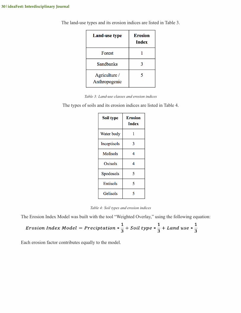
The land-use types and its erosion indices are listed in Table 3.
Table 3: Land-use classes and erosion indices
The types of soils and its erosion indices are listed in Table 4.
Table 4: Soil types and erosion indices
The Erosion Index Model was built with the tool “Weighted Overlay,” using the following equation:
Each erosion factor contributes equally to the model.
30|ideaFest: Interdisciplinary Journal
ideaFest: Interdisciplinary Journal|31
2.2 REMOTE SENSING ANALYSES
For the Remote Sensing analysis proposed by this project, we acquired two Landsat 8 images of the region of Lagoa Feia using Earth Explorer (Table 5)
Table 5: Imagery used in the analyses
The Landsat data was processed using ENVI software according to the flowchart below (Fig. 2). To per-form the map creation was used the software ArcMap.
Figure 2: Flowchart showing the main steps for change detection Lagoa Feia basin
2.2.1 Change Detection Workflows
The change detection of the Lagoa Feia basin was analyzed using three different indices such as, NDVI, NDWI and SPEAR Relative Water Depth to map the vulnerable areas.
2.2.1.1 Normalized Difference Vegetation Index (NDVI)
The objective of this project was to analyze the differences in the NDVI using the lake images from 2013 to 2016.
2.2.1.2 Normalized Difference Water Index (NDWI)
The objective of this project was to analyze the differences in the NDWI using the lake images from 2013 to 2016.
2.2.1.3 Spear Relative Water Depth
For this project we performed two in-depth analyses using the Log Ratio Transform meth-od; one from 2013 and another one from 2016. The following classes were adopted to classify each category of depth (Table 6):
Table 6: Classes of Relative Depth
3. RESULTS
32|ideaFest: Interdisciplinary Journal
ideaFest: Interdisciplinary Journal|33
3.1 Erosion Index Model
The Erosion Index Model indicates that areas with medium and high susceptibility to erosion primarily surround the lake. Sites with Very high susceptibility to erosion were only present in the south of the study area (Fig. 3).
Figure 3: Erosion Index Model created using soil, land-use and the precipitation data in the Lagoa Feia basin
3.2 Remote Sensing Analysis
Relative depth variation was performed using remote sensing and geospatial analysis methods. The results are presented in Fig. 4.
Figure 4: Relative depth variation of Lagoa Feia between 2013 and 2016
By analyzing the map, one can observe that many areas that had a Moderate depth in 2013 now have a Shallow depth in 2016. Measurements of the area were calculated for each of the depth classifications (Table 7).
Table 7: Superficial area of each classification of depth
The area of Shallow depth increased almost 16.5% between these 3 years. Note that Very Shallow, Mod-erate, and Deep depths decreased over this time frame.
34|ideaFest: Interdisciplinary Journal
ideaFest: Interdisciplinary Journal|35
Figure 5: NDWI difference of Lagoa Feia between 2013 and 2016
It is possible to observe that areas near the edges of the lake experienced a decrease of the NDWI (Table 8).
Table 8: Superficial area of NDWI changes
Almost 3% of the lake area experienced a decrease of the NDWI, while no other area of the lake experi-enced an increase (Table 8 & Fig. 6).
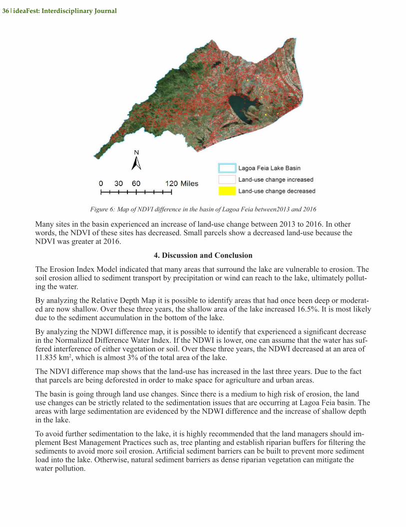
Figure 6: Map of NDVI difference in the basin of Lagoa Feia between2013 and 2016
Many sites in the basin experienced an increase of land-use change between 2013 to 2016. In other words, the NDVI of these sites has decreased. Small parcels show a decreased land-use because the NDVI was greater at 2016.
4. Discussion and Conclusion
The Erosion Index Model indicated that many areas that surround the lake are vulnerable to erosion. The soil erosion allied to sediment transport by precipitation or wind can reach to the lake, ultimately pollut-ing the water.
By analyzing the Relative Depth Map it is possible to identify areas that had once been deep or moderat-ed are now shallow. Over these three years, the shallow area of the lake increased 16.5%. It is most likely due to the sediment accumulation in the bottom of the lake.
By analyzing the NDWI difference map, it is possible to identify that experienced a significant decrease in the Normalized Difference Water Index. If the NDWI is lower, one can assume that the water has suf-fered interference of either vegetation or soil. Over these three years, the NDWI decreased at an area of 11.835 km2, which is almost 3% of the total area of the lake.
The NDVI difference map shows that the land-use has increased in the last three years. Due to the fact that parcels are being deforested in order to make space for agriculture and urban areas.
The basin is going through land use changes. Since there is a medium to high risk of erosion, the land use changes can be strictly related to the sedimentation issues that are occurring at Lagoa Feia basin. The areas with large sedimentation are evidenced by the NDWI difference and the increase of shallow depth in the lake.
To avoid further sedimentation to the lake, it is highly recommended that the land managers should im-plement Best Management Practices such as, tree planting and establish riparian buffers for filtering the sediments to avoid more soil erosion. Artificial sediment barriers can be built to prevent more sediment load into the lake. Otherwise, natural sediment barriers as dense riparian vegetation can mitigate the water pollution.
36|ideaFest: Interdisciplinary Journal
ideaFest: Interdisciplinary Journal|37
About the Authors
Dr. Buddhika Madurapperuma is a Lecturer at the Departments of Environmental Science and Man-agement, and Forestry and Wildland Resources at Humboldt State University (HSU). He conducts multidisciplinary research on land-use/cover change, forest silviculture, and predicting and map-ping invasive species distribution using Geographic Information Systems (GIS) and remote sens-ing techniques. He is passionate about teaching diverse courses at HSU, including Introduction to GIS, Intro/Intermediate Remote Sensing and Mobile Mapping. Dr. Madurapperuma has mentored several students from the Brazil Scientific Mobility Program (BSMP) and his students have pro-duced numerous research outputs through the internship program. For example, he and U.B. Rohrer, a BSMP scholar, produced this article through the 2016 BSMP summer internship program. The authors would like to acknowledge Sara Hanna for the Remote Sensing technical support. Buddhika Madurapperuma can be contacted at [email protected].
Notes 1. A.F Rangel. “A Lagoa Feia E Alguns Impactos Ambientais Associados com a Redução Do Espelho D’água,” IV Simpósio de Geografia. May 29 - June 1, (2007): 83 2. V.S Lima. “Variation of Space: Time Mirror of Water in the Lagoa Feia. R.J,” (master’s thesis, Federal University of Espírito Santo, 2014), 114. 3. L. Tingting, Xiaoyu, S., Dandan, Z., Zhenshan, X., and Jianming. “Assessment of Soil Erosion Risk in Northern Thailand,” The International Archives of the Photogrammetry, Remote Sensing, and Spatial Information Sciences, 37. (2008): 703-708.M.K Jain and D. Das. “Estimation of Sediment Yield and Areas of Soil Erosion and Deposition for Wa-tershed Prioritization Using GIS and Remote Sensing,” Water Resources Management, 24 no. 10 (2009): 2091-2112. 4. J.D. Allan and M.M. Castillo, “Stream Ecology: Structure and Function of Running Waters,” Dordrecht: Springer Publishing, 2007: 436. 5. J.D. Allan. “Landscapes and Riverscapes: The Influence of Land use on Stream Ecosystems,” Annual Review of Ecological and Environmental Systems, 35 (2004): 257-284. 6. M.K Jain and D. Das, “Estimation of Sediment Yield and Areas of Soil Erosion and Deposition for Watershed Prioritization Using GIS and Remote Sensing,” Water Resources Management, 24 no. 10 (2009): 2091-2112. 7. L. Tingting, S. Xiaoyu, Z. Dandan, X. Zhenshan, and Jianming. “Assessment of Soil Erosion Risk in Northern Thailand,” The International Archives of the Photogrammetry, Remote Sensing, and Spatial Information Sciences, 37 (2008): 703-708. 8. Natural Resources Management and Environment Department. (n.d.). “Chapter 2: Pollution by Sediments,” Accessed May 21, 2016, http://www.fao.org/docrep/W2598E/w2598e05.htm 9. C. Sue. GIS (Geographic Information System), 2011, http://nationalgeographic.org/encyclope-dia/geographic-information-system-gis/ st-toolbox/how-weighted-overlay-works.htm 10. ArcGIS (n.d.). Accessed May 21, 2016, http://desktop.arcgis.com/en/arcmap/10.3/ tools/spa-tial-analyst-toolbox/how-weighted-overlay-works.htm 11. S.K. Nick. “A GIS Analysis: Assessing Sediment Loading in the French Creek Sub-Basin Using Two Models. Allegheny College,” (master’s thesis, Allegheny College, 2011). 12. ESA - Eduspace EN, “What is remote sensing?” (n.d.). Acessed June 21, 2016, http://www.esa.int/SPECIALS/Eduspace_EN/SEMF9R3Z2OF_0.html 13. Geomática, S. (n.d.). SOFTWARE ENVI. Accessed April 2, 2016, http://www.softland.com/imagens/ENVI_Site.pdf 14. Exelis VIS Docs Center. (n.d.). “Spectral Indices (Using ENVI),” Accessed March 29, 2016,
http://www.harrisgeospatial.com/docs/SpectralIndices.html 15. S.K McFeeters, “The Use of Normalized Difference Water Index (NDWI) in the Delineation of Open Water Features,” International Journal of Remote Sensing, 17 (1996): 1425-1432. 16. H. XU. “Modification of Normalized Difference Water Index (NDWI) to Enhance Open Water Features in Remotely Sensed Imagery,” Accessed March 29, 2016, https://www.researchgate.net/publication/232724072_Modification_of_Normalized_Difference_Water_Index_NDWI_to_Enhance_Open_Water_Features_in_Remotely_Sensed_Imagery 17. R.P Stumpf, and K. Holderied. “Determination of Water Depth with High-Resolution Satellite Imagery Over Variable Bottom Types”. Liminology and Oceanography, 48 no. 1 (2003): 547-556.
ReferencesAllan, J.D. “Landscapes and Riverscapes: The Influence of Land Use on Stream Ecosystems. Annual Review of Ecological and Environmental Systems,” 35 (2004): 257-284.Allan JD, Castillo. MM Stream Ecology: Structure and Function of Running Waters. Dordrecht: Springer Publishing, 2007. 436.ArcGIS (n.d.). Help. Accessed May 21, 2016,http://desktop.arcgis.com/en/arcmap/10.3/tools/spatial-analysisESA - Eduspace EN. “What is Remote Sensing?” (n.d.), Accessed June 21, 2016, http://www.esa.int/SPECIALS/Eduspace_EN/SEMF9R3Z2OF_0.html Geomática, S. (n.d.). SOFTWARE ENVI. Accessed April 2, 2016, http://www.softland.com/imagens/ENVI_Site.pdf Jain, M.K. and Das, D. “Estimation of Sediment Yield and Areas of Soil Erosion and Deposition for Watershed Prioritization Using GIS and Remote Sensing”. Water Resources Management 24 no. 10 (2009): 2091-2112.Lima, V.S.”Variation of space – Time Mirror of Water in the Lagoa Feia, RJ.” (master’s thesis, Federal University of Espírito Santo,2014):114.McFeeters, S.K., “The Use of Normalized Difference Water Index (NDWI) in the Delineation of Open Water Features.” International Journal of Remote Sensing, 17 (1996): 1425–1432. Natural Resources Management and Environment Department. (n.d.). “Chapter 2: Pollution by Sediments.” Accessed May 21, 2016, http://www.fao.org/docrep/W2598E/w2598e05.htmNick SK. “A GIS Analysis: Assessing Sediment Loading in the French Creek Sub-basin Using Two Models.” (master’s thesis, Allegheny College, 2011).Rangel, A. F. “A Lagoa Feia e Alguns Impactos Ambientais Associados com a Redução do Espelho d’água. IV Simpósio de Geografia; May 29 - June 2, (2007):83.Stumpf, R.P. and Holderied, K. “Determination of Water Depth with High-Resolution Satellite Imagery Over Variable Bottom Types.” Liminology and Oceanography, 48 no. 1 (2003): 547- 556.Sue, C. GIS (Geographic Information System). 2011. Accessed May 21, 2016, http://nationalgeographic.org/encyclopedia/geographic-information-system-gis/ st-toolbox/how- weighted-overlay-works.htmTingting, L., Xiaoyu, S., Dandan, Z., Zhenshan, X., and Jianming. “Assessment of soil Erosion Risk in Northern Thailand.” The International Archives of the Photogrammetry, Remote Sensing, and Spatial Information Sciences 37 (2008): 703-708.XU, H. “Modification of Normalized Difference Water Index (NDWI) to Enhance Open Water Features in Remotely Sensed Imagery.” 2006. Accessed March 29, 2016, https://www.research gate.net/publication/232724072_Modification_of_Normalized_