50
SEMI-DYNAMIC GEOCENTRIC DATUM FOR POSITIONAL ACCURACY AND RELIABILITY IN MALAYSIA NOOR SURYATI BINTI MOHD SHARIFF UNIVERSITI TEKNOLOGI MALAYSIA
SEMI-DYNAMIC GEOCENTRIC DATUM FOR POSITIONAL ACCURACY
AND RELIABILITY IN MALAYSIA
NOOR SURYATI BINTI MOHD SHARIFF
UNIVERSITI TEKNOLOGI MALAYSIA
SEMI-DYNAMIC GEOCENTRIC DATUM FOR POSITIONAL ACURACY AND
RELIABILITY IN MALAYSIA
NOOR SURYATI BINTI MOHD SHARIFF
A thesis submitted in fulfilment of the
requirements for the award of the degree of
Doctor of Philosophy (Geomatic Engineering)
Faculty of Geoinformation and Real Estate
Universiti Teknologi Malaysia
JANUARY 2018

iii
To my beloved family
iv
ACKNOWLEDGEMENT
First and foremost, I would like to express my grateful by saying praise be to
Allah for the accomplishment of this thesis. I wish to express my sincere
appreciation to my supervisor, Dr. Zulkarnaini bin Mat Amin for his support and
guidance throughout this study. I am also very thankful to Associate Professor
Kamaludin bin Haji Mohd Omar, who is my co-supervisor for providing me
continuous motivation. Additionally, I would like to thank Dr. Tajul Ariffin bin
Musa who gave me the opportunity to expose my learning process especially through
international conferences and journal writings.
My sincere appreciation also extends to my postgraduate friends, especially
Mr. Jespal Singh Gill and Mr. Gabriel Ling Hoh Teck who have provided assistance
and discussions at various occasions. The recommendations provided by them were
very useful and were always welcomed as they benefitted my study.
I am also deeply thankful to the Department of Survey and Mapping
Malaysia (DSMM) for providing MyRTKnet and MASS stations’ GPS data used in
this study. Besides, I would like to express my gratitude to the Ministry of Higher
Education (MoHE) for the financial support through a scholarship, namely MyBrain
(MyPhD).
Last but not least, I am deeply indebted to my family members, especially my
husband, who’s my driving force towards the completion of this study. Their
understanding and thoughtfulness throughout my study are appreciated.
v
ABSTRACT
Land movements caused by the Earth's natural systems such as tectonic
motion and earthquakes have a huge impact on the geodetic datum. The geodetic
reference stations that are being used as fiducial points for realizing and maintaining
the geodetic datum may shift positions. In a long term, the geodetic datum may
suffer more severe coordinate shifts, ultimately resulting in non-geocentric position.
The national geodetic datum of Malaysia, the Geocentric Datum of Malaysia
(GDM2000), is realised as a static datum which is aligned to the International
Terrestrial Reference Frame 2000 (ITRF2000) at epoch January 2000. However,
ITRF is currently in version 2014 and Malaysia has experienced several land
movements as a result of tectonic motion (secular) and earthquakes (non-secular).
This study aims to provide the components needed to enhance the accuracy and
reliability of the geodetic datum of Malaysia, outlined in three objectives. First, to
investigate the spatio-temporal domain of land deformation in Malaysia. Second, to
develop a land deformation model based on secular and non-secular land
deformation of Malaysia. Third, to design an appropriate mechanism for the
implementation of a semi-dynamic datum in Malaysia and to validate its accuracy
over time. In order to achieve these objectives, three phases of methodology have
been conducted. In phase one, time series analysis of selected Malaysia Real-time
Kinematic Network (MyRTKnet) stations positions has been carried out using linear
least squares regression technique. The second phase involves the development of a
deformation model using the interpolation approach for secular model and second
degree polynomial method for the post-seismic decay model. The third phase
provides a timeline for implementing a semi-dynamic datum that consists of
information about the applicable epoch and the respective sub-models. In addition,
transformation between the new datum GDM2000 at epoch 2009.3055 and the
existing datum GDM2000 is generated using the geographic offset method. Based on
the time series analysis, it was found that the secular motion of Malaysia can be
classified into two periods of time which are 2008-2011 and 2012-2014 and the
deformation models for Peninsular Malaysia and East Malaysia have to be separated
due to different velocity vectors. Results from assessment of the secular deformation
model have found that millimetre-level accuracy can be achieved, i.e. below 6 mm in
the horizontal position. For the non-secular deformation model, centimetre-level
accuracy can be achieved, i.e. below 7 cm in the horizontal position. It is expected
that with the positional accuracy results obtained in this study, it demonstrates the
feasibility of implementing a semi-dynamic geocentric datum in Malaysia, thus
achieving a reliable position over time.
vi
ABSTRAK
Pergerakan tanah yang disebabkan oleh sistem semula jadi bumi seperti
pergerakan tektonik dan gempa bumi memberi kesan besar kepada datum geodesi.
Stesen rujukan geodesi yang digunakan sebagai titik fidusial untuk menubuh dan
mengekalkan datum geodesi boleh beralih kedudukan. Dalam jangka panjang, datum
geodesi boleh mengalami perubahan koordinat yang lebih teruk, akhirnya
mengakibatkan kedudukan tidak geosentrik. Datum geodesi kebangsaan Malaysia
iaitu datum geosentrik Malaysia (GDM2000) direalisasikan sebagai datum statik
yang selaras dengan kerangka rujukan terestrial antarabangsa 2000 (ITRF2000) pada
epok Januari 2000. Walau bagaimanapun, ITRF kini berada dalam versi 2014 dan
Malaysia telah mengalami beberapa gerakan tanah akibat gerakan tektonik (sekular)
dan gempa bumi (tidak sekular). Kajian ini bertujuan untuk menyediakan komponen-
komponen yang diperlukan untuk meningkatkan ketepatan dan kebolehpercayaan
datum geodesi Malaysia, yang digariskan dalam tiga objektif. Pertama, untuk
menyiasat domain ruang-masa deformasi tanah di Malaysia. Kedua, untuk
membangunkan satu model deformasi tanah berdasarkan deformasi tanah sekular dan
bukan sekular di Malaysia. Ketiga, untuk mereka bentuk mekanisma yang sesuai
untuk pelaksanaan datum separa dinamik di Malaysia dan untuk mengesahkan
ketepatannya dari semasa ke semasa. Bagi mencapai objektif-objektif ini, tiga fasa
metodologi telah dijalankan. Dalam fasa pertama, analisis siri masa bagi kedudukan
stesen-stesen terpilih jaringan masa hakiki kinematik Malaysia (MyRTKnet) telah
dijalankan dengan menggunakan teknik regresi linear kuasa dua terkecil. Fasa kedua
melibatkan pembangunan model deformasi dengan menggunakan pendekatan
interpolasi untuk model sekular dan kaedah polinomial darjah kedua untuk model
pasca-seismik. Fasa ketiga menyediakan satu garis masa untuk melaksanakan datum
separa dinamik yang mengandungi maklumat mengenai kebolehgunaan epok dan
sub-model masing-masing. Tambahan pula, transformasi di antara datum baru
GDM2000 pada epok 2009.3055 dan datum sedia ada GDM2000 dihasilkan dengan
menggunakan kaedah ofset geografi. Berdasarkan analisis siri masa, didapati bahawa
gerakan sekular Malaysia boleh diklasifikasikan kepada dua tempoh masa iaitu 2008-
2011 dan 2012-2014 dan model deformasi untuk Semenanjung Malaysia dan
Malaysia Timur perlu dipisahkan kerana vektor halaju yang berbeza. Keputusan
daripada penilaian model deformasi sekular mendapati bahawa ketepatan tahap
milimeter boleh dicapai, iaitu di bawah 6 mm bagi kedudukan mengufuk. Bagi
model deformasi bukan sekular, ketepatan tahap sentimeter boleh dicapai, iaitu di
bawah 7 sm bagi kedudukan mengufuk. Adalah dijangkakan hasil ketepatan
kedudukan yang diperolehi dalam kajian ini, menunjukkan kebolehlaksanaan datum
geosentrik separa dinamik di Malaysia, seterusnya mencapai kedudukan yang boleh
dipercayai dari semasa ke semasa.
vii
TABLE OF CONTENTS
CHAPTER TITLE PAGE
DECLARATION ii
DEDICATION iii
ACKNOWLEDGEMENTS iv
ABSTRACT v
ABSTRAK vi
TABLE OF CONTENTS vii
LIST OF TABLES xiii
LIST OF FIGURES xv
LIST OF ABBREVIATIONS xxi
LIST OF SYMBOLS xxiv
LIST OF APPENDICES xxvi
1 INTRODUCTION 1
1.1 Research Background 1
1.2 Problem Statements 5
1.3 Research Questions 7
1.4 Research Objectives 7
1.5 Research Scope 8
1.6 Significance of Research 9
1.7 General Research Framework 10
1.8 Thesis Outline 12
viii
2 LITERATURE REVIEW 14
2.1 Introduction 14
2.2 Dynamic Earth 15
2.2.1 Secular Motion 17
2.2.1.1 Plate Tectonic 17
2.2.1.2 Other Secular Motion 19
2.1.2 Non-Secular Motion 20
2.2.2.1 Earthquake 21
2.2.2.2 Other Non-Secular Motion 22
2.2.3 Geodynamics in Malaysia 23
2.3 Geodetic Reference Systems, Frames and
Geodetic Datum 25
2.3.1 Hierarchy of Current Terrestrial Reference
Frames 27
2.3.1.1 Global Terrestrial Reference Frame 28
2.3.1.1.1 The International Terrestrial
Reference Frame (ITRF) 28
2.3.1.1.2 The World Geodetic System
1984 (WGS84) 30
2.3.1.1.3 The GNSS Associated
Reference Frames 32
2.3.1.2 Regional Terrestrial Reference
Frames 32
2.3.1.3 National Terrestrial Reference
Frame 33
2.3.2 National Geodetic Datum in Malaysia 34
2.3.2.1 History of the Geodetic Datum
in Malaysia 34
2.3.2.2 GPS-Based Network 36
2.3.2.3 Geocentric Datum of Malaysia
(GDM2000) 39
2.4 The Relation of National Geocentric Datum to
Earth Dynamic 40
2.4.1 Implication of the Geocentric Datum Shift 40
2.4.1.1 Inconsistent Satellite Orbit and
Coordinate Bias 41
2.4.1.2 Confusion and Mismatch with
Base Map 42
ix
2.4.1.3 Decreased Accuracy of Reference
Stations Coordinates 42
2.4.1.4 Managing the Geospatial Database 43
2.4.2 Preliminary Test on the Shift of GDM2000 43
2.4.2.1 Test I: Comparison between Epoch
2000 and 2011 in the Same Reference
Frame ITRF2000 43
2.4.2.2 Test II: Comparison between Epoch
2000 and 2011 in Different Reference
Frames: ITRF2000 and ITRF2008,
Respectively 44
2.4.2.3 Test III: Comparison between
ITRF2000 and ITRF2008 Reference
Frames at Same Epoch 2011 47
2.4.2.4 Test IV: Time Series Analysis for
Coordinates Difference between
Epoch 2011 in ITRF2000 and the
GDM2000 (2006) 47
2.4.3 The choice of Datum: Static, Semi-Dynamic
and Dynamic 49
2.4.3.1 Static Datum 50
2.4.3.2 Semi-Dynamic Datum 50
2.4.3.3 Dynamic Datum 50
2.5 Review on Semi-Dynamic Geocentric Datum 51
2.5.1 Deformation Model 53
2.5.2 Issues of a Semi-Dynamic Geocentric Datum 54
2.6 Summary 56
3 RESEARCH METHODOLOGY 58
3.1 Introduction 58
3.2 Research Framework 59
3.3 Research Materials and Tools 61
3.3.1 GPS Data 61
3.3.2 Research Tools 62
3.3.2.1 Bernese 5.0 GNSS Software 62
3.3.2.2 GPS Interactive Time Series Analysis
(GITSA) Software 64
3.3.2.3 Global Mapping Tools (GMT) Tools 66
x
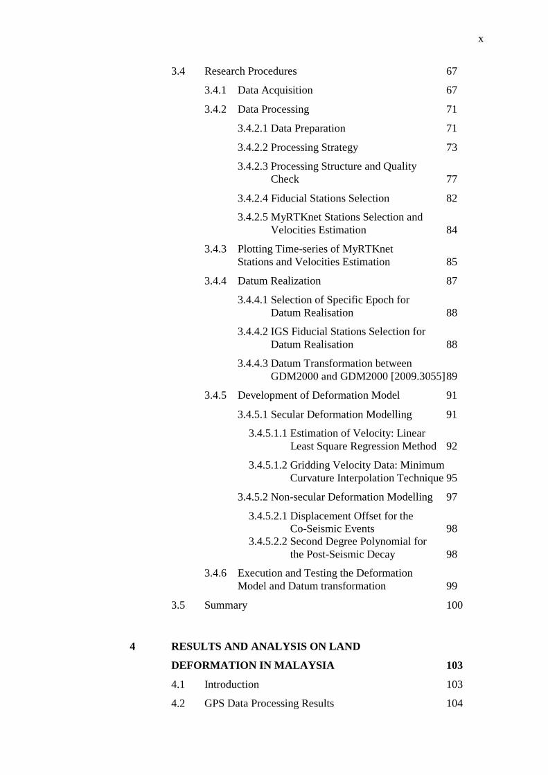
3.4 Research Procedures 67
3.4.1 Data Acquisition 67
3.4.2 Data Processing 71
3.4.2.1 Data Preparation 71
3.4.2.2 Processing Strategy 73
3.4.2.3 Processing Structure and Quality
Check 77
3.4.2.4 Fiducial Stations Selection 82
3.4.2.5 MyRTKnet Stations Selection and
Velocities Estimation 84
3.4.3 Plotting Time-series of MyRTKnet
Stations and Velocities Estimation 85
3.4.4 Datum Realization 87
3.4.4.1 Selection of Specific Epoch for
Datum Realisation 88
3.4.4.2 IGS Fiducial Stations Selection for
Datum Realisation 88
3.4.4.3 Datum Transformation between
GDM2000 and GDM2000 [2009.3055] 89
3.4.5 Development of Deformation Model 91
3.4.5.1 Secular Deformation Modelling 91
3.4.5.1.1 Estimation of Velocity: Linear
Least Square Regression Method 92
3.4.5.1.2 Gridding Velocity Data: Minimum
Curvature Interpolation Technique 95
3.4.5.2 Non-secular Deformation Modelling 97
3.4.5.2.1 Displacement Offset for the
Co-Seismic Events 98
3.4.5.2.2 Second Degree Polynomial for
the Post-Seismic Decay 98
3.4.6 Execution and Testing the Deformation
Model and Datum transformation 99
3.5 Summary 100
4 RESULTS AND ANALYSIS ON LAND
DEFORMATION IN MALAYSIA 103
4.1 Introduction 103
4.2 GPS Data Processing Results 104
xi
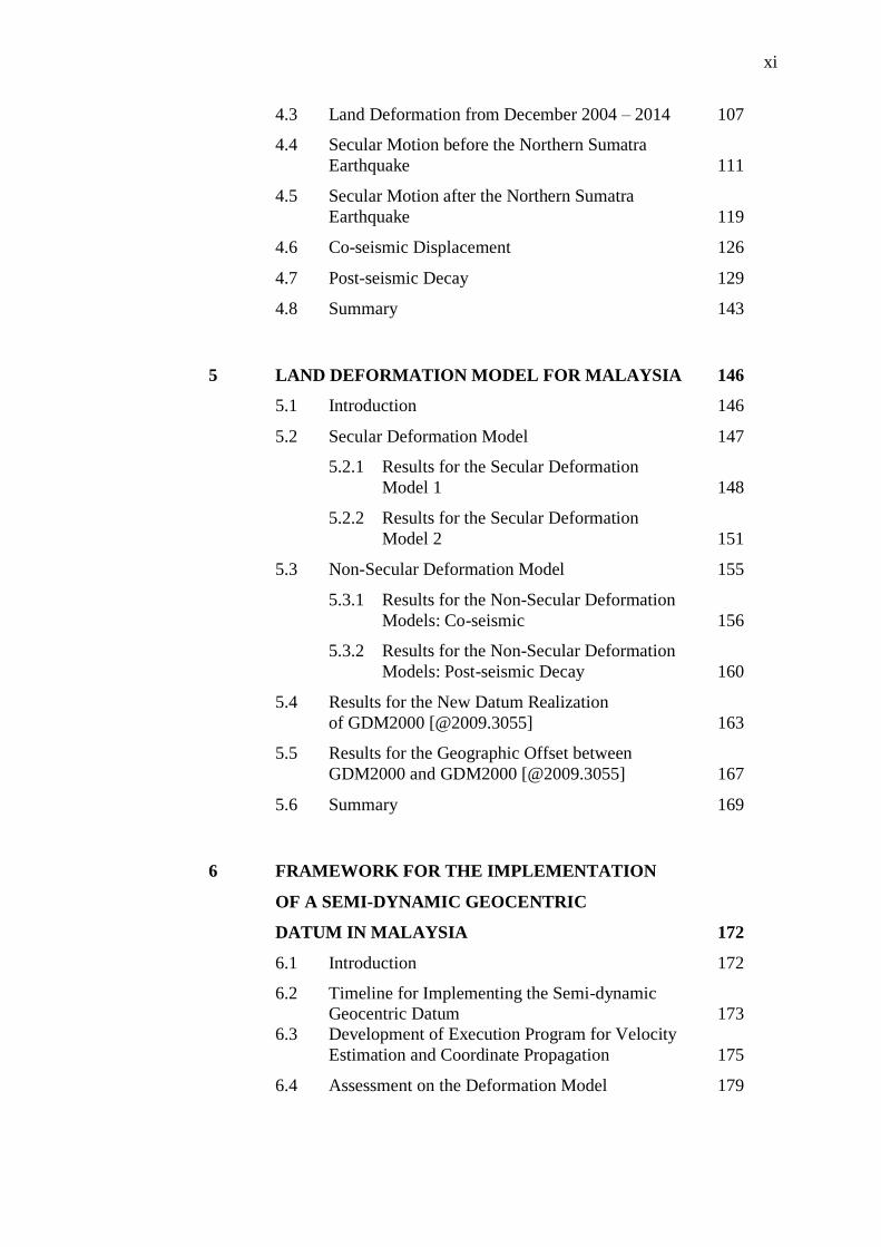
4.3 Land Deformation from December 2004 – 2014 107
4.4 Secular Motion before the Northern Sumatra
Earthquake 111
4.5 Secular Motion after the Northern Sumatra
Earthquake 119
4.6 Co-seismic Displacement 126
4.7 Post-seismic Decay 129
4.8 Summary 143
5 LAND DEFORMATION MODEL FOR MALAYSIA 146
5.1 Introduction 146
5.2 Secular Deformation Model 147
5.2.1 Results for the Secular Deformation
Model 1 148
5.2.2 Results for the Secular Deformation
Model 2 151
5.3 Non-Secular Deformation Model 155
5.3.1 Results for the Non-Secular Deformation
Models: Co-seismic 156
5.3.2 Results for the Non-Secular Deformation
Models: Post-seismic Decay 160
5.4 Results for the New Datum Realization
of GDM2000 [@2009.3055] 163
5.5 Results for the Geographic Offset between
GDM2000 and GDM2000 [@2009.3055] 167
5.6 Summary 169
6 FRAMEWORK FOR THE IMPLEMENTATION
OF A SEMI-DYNAMIC GEOCENTRIC
DATUM IN MALAYSIA 172
6.1 Introduction 172
6.2 Timeline for Implementing the Semi-dynamic
Geocentric Datum 173
6.3 Development of Execution Program for Velocity
Estimation and Coordinate Propagation 175
6.4 Assessment on the Deformation Model 179

xii
6.4.1 Assessment on the Secular Deformation
Model 1 180
6.4.2 Assessment on the Secular Deformation
Model 2 183
6.4.3 Assessment on the Non-secular (Co-seismic)
Deformation Model 185
6.4.4 Assessment on the Non-secular
(Post-seismic Decay) Deformation Model 187
6.4.5 Assessment on the Geographic Offset
Transformation and Deformation Model
for the Campaign Points 190
6.5 Discussion on Implementing a Semi-Dynamic
Geocentric Datum in Malaysia 197
6.5.1 Resistance to Change 197
6.5.2 Integration between New Geospatial
Data and Mapping 198
6.5.3 Implications 199
6.6 Summary 200
7 CONCLUSION AND RECOMMENDATIONS 203
7.1 Conclusion 203
7.2 Recommendations for Future Research 207
REFERENCES 210
Appendices A – D 221 - 228
xiii
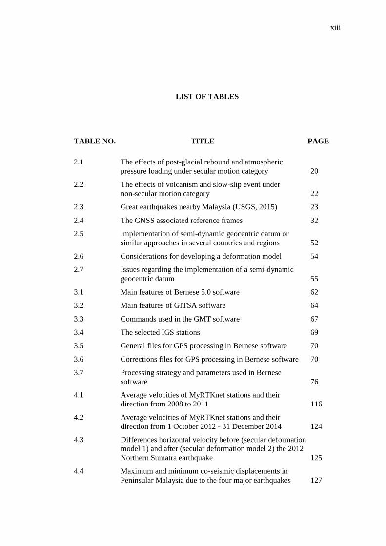
LIST OF TABLES
TABLE NO. TITLE PAGE
2.1 The effects of post-glacial rebound and atmospheric
pressure loading under secular motion category 20
2.2 The effects of volcanism and slow-slip event under
non-secular motion category 22
2.3 Great earthquakes nearby Malaysia (USGS, 2015) 23
2.4 The GNSS associated reference frames 32
2.5 Implementation of semi-dynamic geocentric datum or
similar approaches in several countries and regions 52
2.6 Considerations for developing a deformation model 54
2.7 Issues regarding the implementation of a semi-dynamic
geocentric datum 55
3.1 Main features of Bernese 5.0 software 62
3.2 Main features of GITSA software 64
3.3 Commands used in the GMT software 67
3.4 The selected IGS stations 69
3.5 General files for GPS processing in Bernese software 70
3.6 Corrections files for GPS processing in Bernese software 70
3.7 Processing strategy and parameters used in Bernese
software 76
4.1 Average velocities of MyRTKnet stations and their
direction from 2008 to 2011 116
4.2 Average velocities of MyRTKnet stations and their
direction from 1 October 2012 - 31 December 2014 124
4.3 Differences horizontal velocity before (secular deformation
model 1) and after (secular deformation model 2) the 2012
Northern Sumatra earthquake 125
4.4 Maximum and minimum co-seismic displacements in
Peninsular Malaysia due to the four major earthquakes 127
xiv
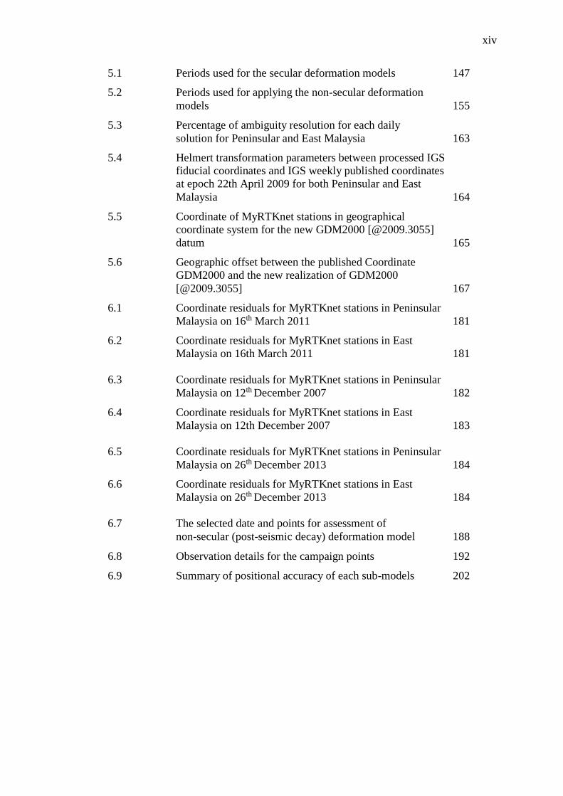
5.1 Periods used for the secular deformation models 147
5.2 Periods used for applying the non-secular deformation
models 155
5.3 Percentage of ambiguity resolution for each daily
solution for Peninsular and East Malaysia 163
5.4 Helmert transformation parameters between processed IGS
fiducial coordinates and IGS weekly published coordinates
at epoch 22th April 2009 for both Peninsular and East
Malaysia 164
5.5 Coordinate of MyRTKnet stations in geographical
coordinate system for the new GDM2000 [@2009.3055]
datum 165
5.6 Geographic offset between the published Coordinate
GDM2000 and the new realization of GDM2000
[@2009.3055] 167
6.1 Coordinate residuals for MyRTKnet stations in Peninsular
Malaysia on 16th March 2011 181
6.2 Coordinate residuals for MyRTKnet stations in East
Malaysia on 16th March 2011 181
6.3 Coordinate residuals for MyRTKnet stations in Peninsular
Malaysia on 12th December 2007 182
6.4 Coordinate residuals for MyRTKnet stations in East
Malaysia on 12th December 2007 183
6.5 Coordinate residuals for MyRTKnet stations in Peninsular
Malaysia on 26th December 2013 184
6.6 Coordinate residuals for MyRTKnet stations in East
Malaysia on 26th December 2013 184
6.7 The selected date and points for assessment of
non-secular (post-seismic decay) deformation model 188
6.8 Observation details for the campaign points 192
6.9 Summary of positional accuracy of each sub-models 202
xv
LIST OF FIGURES
FIGURE NO. TITLE PAGE
1.1 The general research framework 11
2.1 The classification of secular and non-secular motion
(Stanaway et al., 2012) 16
2.2 The major plate tectonics and several subplates on the
Earth (Hamblin and Christiansen, 2009) 17
2.3 Post-seismic and co-seismic motions in Peninsular
Malaysia (Omar, et al., 2010) 24
2.4 The hierarchical relationship between reference frames 27
2.5 ITRF2008 network encompassed with VLBI, SLR, DORIS
and GPS sites co-located with GPS (Altamimi et al., 2011) 29
2.6 WGS 84 (G1150) reference frame stations
(Altamimi et al., 2012) 31
2.7 Geodetic triangulation network for Malayan Revised
Triangulation 1968 (MRT68) (DSMM, 2009) 35
2.8 Geodetic triangulation network for Borneo
Triangulation 1968 (BT68) (DSMM, 2009) 36
2.9 Peninsular Malaysia Scientific Geodetic Network 1994
(PMSGN94) (DSMM, 2004) 37
2.10 East Malaysia Geodetic Scientific Network 1997
(EMGSN97) (DSMM, 2004) 38
2.11 Coordinate bias in the relative positioning 41
2.12 Comparison between Epoch 2000 and Epoch 2011
in ITRF2000 45
2.13 Comparison between Epoch 2000 in ITRF2000 and
Epoch 2011 in ITRF2008 46
xvi
2.14 Comparison between ITRF2000 and ITRF2008 at
epoch 2011 48
2.15 Time series of displacement at ARAU, KUKP,
MUKH, RANA and SARA stations 49
3.1 Research framework for the development of a
semi-dynamic geocentric datum 59
3.2 The distribution of 78 MyRTKnet stations (DSMM, 2009) 68
3.3 The distribution of 17 MASS stations (DSMM, 2009) 69
3.4 Summary of the folders and files involved in data
preparation of Bernese software 73
3.5 Preparation step of the RNX2SNX processing structure 78
3.6 Pre-processing step of the RNX2SNX processing structure 79
3.7 Processing step of the RNX2SNX processing structure 80
3.8 Summary and deleting step of the RNX2SNX
processing structure 81
3.9 The network of selected fiducial and non-fiducial
stations for GPS processing 83
3.10 Selected 65 MyRTKnet stations for the GPS
data processing 85
3.11 The resultant slope represents velocity and diagonal
covariance matrix represents varians 87
3.12 The network of selected fiducial and non-fiducial
stations for a new datum realization 89
3.13 Common points that have been selected for Peninsular
Malaysia 90
3.14 Common points that have been selected for East Malaysia 91
4.1 Ambiguity results from the summarized GPSQIF output 104
4.2 Helmert residuals results from HELMR1 105
4.3 Positional errors results from the summarized final
ADDNEQ2 output 105
4.4 Summarized output from MAUPRP 106
4.5 Summarized output from RESCHK 106
4.6 Zones for spatial analysis of land deformation 107
4.7 UPMS station time series affected by all the nearby
earthquakes 108
4.8 Time series of BIN1 (left) and KENI (right) MyRTKnet
stations located in Sarawak and Sabah, respectively 109
4.9 Time series of UUMK (left) and GMUS (right)
xvii
MyRTKnet stations located in North-west and
North-east zones, respectively 110
4.10 Time series of MERU (left) and JHJY (right)
MyRTKnet stations located in Central and South zones 110
4.11 Time series of UUMK station and velocity from 2008
to 2011 112
4.12 Time series of PUSI station and velocity from 2008
to 2011 113
4.13 Time series of KUAL station and velocity from 2008
to 2011 114
4.14 Time series of UPMS station and velocity from 2008
to 2011 114
4.15 Time series of KUKP station and velocity from 2008
to 2011 115
4.16 Time series of KUDA station and velocity from 2008
to 2011 115
4.17 Time series of BIN1 station and velocity from 2008
to 2011 116
4.18 MyRTKnet velocity vector map for the 2008 to 2011
period 118
4.19 Time series of UUMK station and velocity from
1 October 2012 to 31 December 2014 120
4.20 Time series of KUAL station and velocity from
1 October 2012 to 31 December 2014 121
4.21 Time series of UPMS station and velocity from
1 October 2012 to 31 December 2014 121
4.22 Time series of KUKP station and velocity from
1 October 2012 to 31 December 2014 122
4.23 Time series of KUDA station and velocity from
1 October 2012 to 31 December 2014 122
4.24 Time series of BIN1 station and velocity from
1 October 2012 to 31 December 2014 123
4.25 MyRTKnet velocity vector map for the October 2012
to 2014 period 125
4.26 Co-seismic displacement during (a) 2004 Acheh,
(b) 2005 Nias, (c) 2007 Bengkulu and (d) 2012 Northern
Sumatra earthquakes with the blue star indicates the
location of the respective earthquake’s epicenter 128
4.27 Post-seismic decay for the Sumatra-Andaman
earthquake at LGKW station 130
4.28 Post-seismic decay for the Sumatra-Andaman
xviii
earthquake at GMUS station 131
4.29 Post-seismic decay for the Sumatra-Andaman
earthquake at JHJY station 132
4.30 Post-seismic decay for the Nias earthquake at
LGKW station 134
4.31 Post-seismic decay for the Nias earthquake at
GMUS station 135
4.32 Post-seismic decay for the Nias earthquake at
JHJY station 136
4.33 Post-seismic decay for the Northern Sumatra earthquake
at LGKW station 138
4.34 Post-seismic decay for the Northern Sumatra earthquake
at GMUS station 139
4.35 Post-seismic decay for the Northern Sumatra earthquake
at JHJY station 140
4.36 Post-seismic decay for the Northern Sumatra earthquake
at KUDA station 141
4.37 Post-seismic decay for the Northern Sumatra earthquake
at BIN1 station 142
5.1 Secular deformation model 1 for Peninsular Malaysia:
East component 149
5.2 Secular deformation model 1 for Peninsular Malaysia:
North component 149
5.3 Secular deformation model 1 for East Malaysia:
East component 150
5.4 Secular 1 deformation model 1 for East Malaysia:
North component 150
5.5 Secular deformation model 2 for Peninsular
Malaysia: East component 152
5.6 Secular deformation model 2 for Peninsular
Malaysia: North component 153
5.7 Secular deformation model 2 for East Malaysia:
East component 154
5.8 Secular deformation model 2 for East Malaysia:
North component 154
5.9 Non-secular deformation model 1 (co-seismic
Sumatra-Andaman earthquake) for Peninsular Malaysia:
East component 156
5.10 Non-secular deformation model 3 (co-seismic Nias
earthquake) for Peninsular Malaysia: East component 157
xix
5.11 Non-secular deformation model 5 (co-seismic
Bengkulu earthquake) for Peninsular Malaysia:
East component 158
5.12 Non-secular deformation model 6 (co-seismic
Northern Sumatra earthquake) for Peninsular Malaysia:
East component 159
5.13 Post-seismic model for Sumatra-Andaman earthquake
in East component at PUPK Station 161
5.14 Post-seismic model for Sumatra-Andaman earthquake
in North component at PUPK Station 161
5.15 Post-seismic model for Nias Earthquake in East
component at PUPK Station 162
5.16 Post-seismic model for Nias Earthquake in North
component at PUPK Station 162
6.1 Timeline for implementing a semi-dynamic geocentric
datum for Malaysia 174
6.2 The interface of a Velocity Estimation and Coordinate
Propagation (VEaCoP) Program 176
6.3 Process framework of the Velocity Estimation and
Coordinate Propagation (VEaCoP) program 177
6.4 Estimation of velocity or/and displacement value for a
specific user location by using bilinear interpolation
method 179
6.5 Coordinate residuals in North component for the
non-secular deformation model which are the
co-seismic of Acheh in green line, Nias in red line,
Bengkulu in yellow line and Northern Sumatra in blue line 185
6.6 Coordinate residuals in East component for the
non-secular deformation model which are the
co-seismic of Acheh in green line, Nias in red line,
Bengkulu in yellow line and Northern Sumatra in blue line 186
6.7 Coordinate residuals in North component for the
non-secular deformation model which are the
post-seismic of Acheh in green bar, Nias in red bar and
Northern Sumatra in blue bar 188
6.8 Coordinate residuals in East component for the
non-secular deformation model which are the
post-seismic of Acheh in green bar, Nias in red bar
and Northern Sumatrain blue bar 189
6.9 Location of the campaign points around Peninsular
Malaysia 191
6.10 Location of the campaign points around Sarawak 191

xx
6.11 Scatter plot of coordinate residuals of East and North
component for evaluation of geographic offset
transformation in Peninsular Malaysia 193
6.12 Scatter plot of coordinate residuals of East and North
component for evaluation of geographic offset
transformation in Sarawak 194
6.13 Coordinate residuals of campaign points for evaluation
of deformation model in Peninsular Malaysia 195
6.14 Coordinate residuals of campaign points for evaluation
of deformation model in Sarawak 196
xxi
LIST OF ABBREVIATIONS
APREF - Asia-Pacific Reference Frame
BIH - Bureau International de I'Heure
BIPM - Bureau International des Poids et Mesures
BPE - Bernese Processing Engine
BT - Borneo Triangulation
CORS - Continuously Operating Reference Stations
CTF2000 - China Terrestrial Reference Frame 2000
DGFI - German Geodetic Research Institute
DGRS - Differential GPS Reference Stations
DMA - Defense Mapping Agency
DoD - Department of Defense
DORIS - Doppler Orbitography and Radiopositioning Integrated
by Satellites
DOS - Disk Operating System
DoY - Day of Year
DSMM - Department of Survey and Mapping Malaysia
ECEF - Earth-centered Earth-fixed
EMSGN97 - East Malaysia Scientific Geodetic Network 1997
EOP - Earth Orientation Parameter
EUREF - European Reference Frame
FTP - File Transfer Protocol
GDM2000 - Geocentric Datum of Malaysia 2000
GGOS - Global Geodetic Observing System
GIA - Glacial Isostatic Adjustment
GIS - Geographical Information System
GITSA - GPS Interactive Time Series Analysis
GMT - Global Mapping Tools
xxii
GNSS - Global Navigation Satellite System
GPS - Global Positioning System
GSHHG - Global Self-consistent, Hierarchical, High-resolution
Geography Database
GUI - Graphical User Interface
IAG - International Association of Geodesy
ICRF - International Celestial Reference Frame
IERS - International Earth Rotation and Reference Systems
Service
IGN - Institute Geographique National
IGS - International GNSS Service
IRM - IERS Reference Meridian
IRP - IERS Reference Pole
ITRF - International Terrestrial Reference Frame
ITRF - International Terrestrial Reference Frame
ITRS - International Terrestrial Reference System
JGD2000 - Japan Geocentric Datum 2000
KGD2000 - Korean Geodetic Datum 2000
LLR - Lunar Laser Ranging
MASS - Malaysian Active GPS System
MRT - Malayan Revised Triangulation
MyRTKnet - Malaysia Real Time Kinematic GNSS Network
NDCDB - National Digital Cadastral Database
NGA - National Geospatial-Intelligence Agency
NIMA - National Imagery and Mapping Agency
NNR - No-Net-Rotation
NRCan - Natural Resources Canada
NSWCDD - Naval Surface Warfare Center Dahlgren Division
NZGD2000 - New Zealand Geodetic Datum 2000
PCF - Process Control File
PMSGN94 - Peninsular Malaysia Scientific Geodetic Network 1994
PPP - Precise Point Positioning
QIF - Quasi Ionosphere Free
RINEX - Receiver Independent Exchange Format

xxiii
SIRGAS - Geocentric Reference System for Americas
SLR - Satellite Laser Ranging
TAI - International Atomic Time
TCG - Geocentric Coordinate Time
VLBI - Very Long Baseline Interferometry
WGS - World Geodetic System
WGS84 - World Geodetic System 1984
xxiv
LIST OF SYMBOLS
- Position at the epoch of to
- Velocity at the epoch of ti
- Reference epoch
- Target epoch
- Difference of time
i
i tdX - The summation includes various “high-frequency”
motions affecting site position
- Residuals
- Vertical distances between the points of the observed
data set
- Fitted line
- X-axis data set (time)
- Slope coefficient
- Intercept coefficient
- Variance
- Number of observation
- Number of parameters
- Design matrix
- Observation matrix
- Weight matrix
- Tension parameter
- Laplacian operator
- Biharmonic operator
- Displacement offset for East component

xxv
- Displacement offset for North component
- First coefficient of polynomial
- Second coefficient of polynomial
- Third coefficient of polynomial
- Geographic longitude
- Geographic latitude
- Difference in the geographic longitude
- Difference in the geographic latitude
xxvi
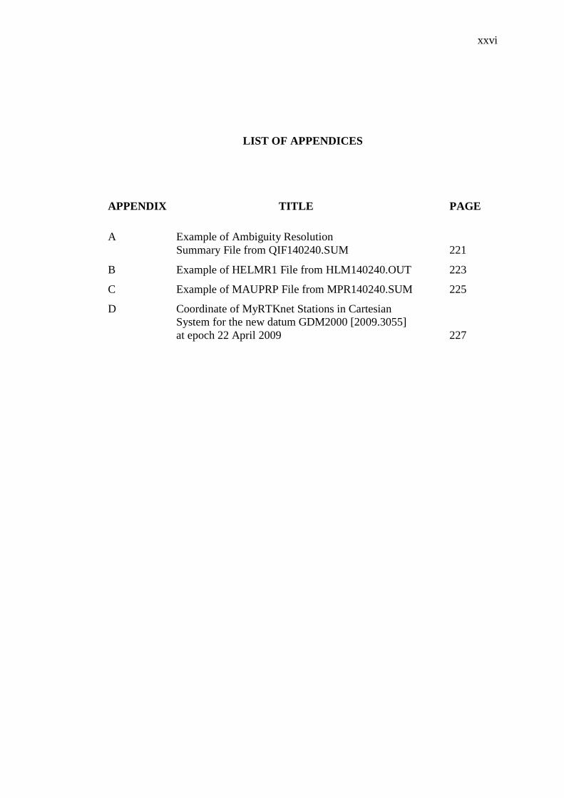
LIST OF APPENDICES
APPENDIX TITLE PAGE
A Example of Ambiguity Resolution
Summary File from QIF140240.SUM 221
B Example of HELMR1 File from HLM140240.OUT 223
C Example of MAUPRP File from MPR140240.SUM 225
D Coordinate of MyRTKnet Stations in Cartesian
System for the new datum GDM2000 [2009.3055]
at epoch 22 April 2009 227
CHAPTER 1
INTRODUCTION
1.1 Research Background
A geodetic datum plays an important role as a reference for determining
coordinates of points on the earth. From time to time, the geodetic datum has to be
improved in accordance with the advances of space-based measurement technology
and modernization in the field of Geodesy. One of the elements considered in
modern geodesy is Geokinematics, of which the kinematics and variations of the
Earth may directly affect the Earth's surface, thus, disturbing the precision of the
geodetic datum (or the global datum, i.e. geocentric datum). Therefore, it is essential
to understand the movement of the earth that directly affects the geocentric datum
and the extent to which these effects may impact positioning accuracy.
Generally, the earth is a complex and dynamic system which is undergoing
tectonic plate motion, rotational motion, core-mantel dynamics and changes of mass
loads, which include the atmosphere, ocean and crust. One of the most direct
economic and social effects is a large destructive phenomenon called earthquake.
This phenomenon is usually the result of geological deformation from the slip
between tectonic plates (Wang et al., 2012). During an earthquake, also known as the
co-seismic period, energy releases instantaneously to the crust and causing a great
impact, in the form of displacement, to the land. For instance, the 26 December 2004
Sumatra–Andaman megathrust earthquake significantly affected land displacements
up to 10 cm in magnitude with a radius of 400 km away from the earthquake’s
epicentre (Vigny et al., 2005) during its co-seismic period. In fact, this land
2
displacement, or land deformation, may cause a motion even after the earthquake, in
order to return to its equilibrium state, which can last up for a couple of years or
decades. A specific term for this phase is the post-seismic motion, resulting in
significant amount of land displacement, i.e. centimetres to decimetres per year (Hu
and Wang, 2012), over a long period of time, as well as the post-seismic decay
motion which is a short term motion after an earthquake. Co-seismic, post-seismic,
and post-seismic decay, motions randomly occur and depend on the specific
geological deformation pattern, hence, they are typically classified as non-secular
motion. A steady-state motion associated with plate tectonic motion is classified as
secular motion (Blick et al., 2005). Tectonic plates have a normal internal forcing of
heat transported out of the hot core and mantle to the Earth’s surface (Hamblin and
Christiansen, 2009). Consequently, these plates move gradually and varyingly, with
velocities up to a few centimetres annually.
In Malaysia, since the occurrence of the mega earthquake of 2004, the
country has been affected by significant land deformation. In fact, Malaysia has
experienced heterogeneous land deformation both in spatial and temporal aspects.
For example, the northern parts of Peninsular Malaysia, i.e. Arau and Langkawi,
have experienced up to 17 cm in land deformation during the 2004 Sumatra–
Andaman earthquake (Omar and Jhonny, 2009). In addition, few series of
earthquakes such as 2005 Nias, 2007 Bengkulu and 2012 Northern Sumatra also
influenced the land deformation in the country. Furthermore, with a significant
impact of post-seismic decay motion that occurred from these earthquake events, it
will worsen the land deformation and distort the national geocentric datum.
In many countries, a geocentric datum is typically being implemented by
adopting a global datum: the International Terrestrial Reference Frame (ITRF).
Among the drives for a geocentric datum are the increasing use of satellite-based
positioning systems such as Global Positioning System (GPS) and the need of global
or unified coordinate system. However, the geocentric datum is only fully compatible
with the ITRF at a certain epoch, whereby most of the national geocentric datums
remain as a static datum where all site coordinates are fixed or assumed unchanged
with time.
3
Thus, the accuracy of a geocentric datum decreases over the time, if land
deformations are not taken into account. It is because tectonic plate motions will
dislocate the GPS reference stations over time, thus affecting the geocentric datum
causing it to be no longer geocentric (non-geocentric) and does not represent the
“true” position of the geodetic stations. The consequence does not only affect the
activities of survey and mapping, but will also have a big impact on resource-grade
activities, involving socio-economic and environmental activities in general.
In Malaysia, the Geocentric Datum of Malaysia 2000 (GDM2000) was
developed by the Department of Survey and Mapping Malaysia (DSMM) to provide
a global and homogeneous coordinate system across the country. The realization of
the GDM2000 was based on the ITRF2000 at epoch 1st January 2000 (DSMM,
2009). Since Malaysia has experienced land deformation due to plate tectonic motion
and a series of earthquakes, thus, there are a number of questions raised: (1) is the
current GDM2000 sufficiently reliable to be utilised for present positioning practice
when associated with inexorable motion due to tectonic plates and earthquakes? (2)
how does the GDM2000 account for heterogeneous land deformations in terms of
spatio-temporal? and (3) how to obtain accurate coordinates as function of time?
Therefore, there is a need for a comprehensive strategy to enhance and maintain high
geospatial accuracy of the geocentric datum in terms of consistency to the ITRF and
reliability of the positioning results with respect to time.
Possible options for datum enhancement are by implementing semi-dynamic
or dynamic geocentric datum. Both options enable the coordinates to be updated
from one epoch to another. The difference between these datum are the reference
epoch, whereby the semi-dynamic geocentric datum only updates coordinates at a
defined reference epoch and deals with coordinate propagation to/from that reference
epoch. Semi-dynamic geocentric datum requires study on the selection of a reference
epoch which is within a stable seismic period and requires to determine the
appropriate update rate according to the seismic activities and datum accuracy over
time. Meanwhile, the dynamic datum is always updating the coordinates based on
current epoch and constantly associated to the ITRF. The reference epoch for
dynamic datum keeps on changing periodically such as weekly, monthly, or yearly;
4
thus introducing an array of epochs (Grant and Blick, 1998). Hence, the semi-
dynamic geocentric datum is a more practical and reasonable approach to be
implemented rather than a dynamic datum so as to avoid confusion at the end-user
level, e.g., surveyors, due to continuously changing reference coordinates.
The semi-dynamic geocentric datum includes a land deformation model that
enables coordinates to be ‘corrected’ by absorbing the deformation event into the
solution. Therefore, the coordinates in a semi-dynamic geocentric datum represents
the actual position with respect to the deformation event and time. There are only a
few countries that have initiated the implementation of a semi-dynamic geocentric
datum, for example, New Zealand (Blick et al., 2005) and Papua New Guinea
(Stanaway, 2004). It is believed that the number of countries that develop the semi-
dynamic geocentric datum is increasing over time, especially when there are
significant land deformations in or nearby the country such as Indonesia (Susilo et
al., 2015) and Taiwan (Ching and Chen, 2015). Nevertheless, Malaysia is presently
still adopting a conventional static datum even though it is affected by severe co-
seismic and post-seismic motions. Hence, for Malaysia to achieve accurate and
reliable positions with respect to time, a semi-dynamic geocentric datum approach is
recommended.
The implementation of a semi-dynamic geocentric datum has several issues
that need to be properly considered to ensure its feasibility, such as: (1) duration or
frequency for updating the geocentric datum, (2) the desired positional accuracy, (3)
the deformation model development related to spatial-temporal variation, (4) the
appropriate transformation parameters to relate former and later geodetic datums, and
(5) cost-benefit of the implementation. There are also several possible challenges that
will be raised such as resistant to changes into the new approach and managing the
dynamic database.
5
1.2 Problem Statements
The phenomena of secular and non-secular motions will distort the geodetic
infrastructures, i.e. Continuously Operating Reference Stations (CORS), up to few
centimetres or decimetres, depending on the magnitude of the plate tectonics. Thus, it
affects the geocentric datum causing it to no longer be reliable to represent the
current (epoch) position of points. In the case of Malaysia, GDM2000 is still
implemented as a static datum with more than 10 years of duration without updating
the reference datum. Consequently, over time, the national geocentric datum does not
represent the real meaning of geocentric anymore and the relation of the national
geocentric datum with satellite-based geodetic technology such as GPS would not be
truly compatible. Furthermore, if the national geocentric datum is not accurate, it will
have profound effects associated with misinterpretation and wrong decision making
on land, property and security-related matters. For instance, there is a risk in cadastre
that involves disputes in land parcels, whereby if the measurements are not legally
traceable to its source, it could be challenged in court. The source for GDM2000 is
ITRF2000, of which currently is in version ITRF2014. Therefore, regular datum
updates must be carried out on the geodetic infrastructure by considering the land
deformation due to plate tectonics.
Even though Malaysia is not situated at the subduction zone, it is still
subjected to significant land deformation during the co-seismic and post-seismic as it
is nearby the Ring of Fire subduction zone. According to Vigny et al. (2005) and
Omar and Jhonny (2009), the largest displacement recorded in Peninsular Malaysia
during Sumatra-Andaman earthquake was the North-West part (MyRTKnet stations:
Langkawi with 17 cm, Arau with 13.7 cm, Sungai Petani with 12.8 cm and Universiti
Sains Malaysia, Penang with 12.5 cm). Meanwhile the smallest displacement was at
the South-East part (MyRTKnet stations: Tanjung Pengelih with 2 cm, Johor Jaya
with 1.9 cm, Pekan with 2.6 cm and Mersing with 3.5 cm). These trends indicate that
there are absolutely heterogeneous land deformation in Peninsular Malaysia.
Although geodynamics studies in Malaysia have shown the results of its tectonic
setting, e.g. Omar and Jhonny (2009), but there is no further research to
comprehensively model the land deformation especially in resolving the issue of an
6
outdated geocentric datum. Besides, the study by Jhonny (2010) only used data from
December 2004 to December 2008 and did not cover the land deformation in East
Malaysia, i.e. Sabah and Sarawak. Hence, the development of deformation model
that covers the entire Malaysia is needed by providing specific approach for
developing the secular and non-secular sub-models. It is also very important for the
effects of post-seismic decay not to be neglected, especially after a strong
earthquake, whereby significant effects of land movements, e.g. up to a few
centimetres, are able to occur with unique decay patterns which are not linear and
can last for several years. Therefore, the inclusion of post-seismic decay motion as
part of the non-secular sub-model will significantly contribute to the development of
a deformation model, since existing deformation models do not include the post-
seismic decay element.
One of the major concerns for implementing a semi-dynamic geocentric
datum is the relation between the updated datum and previous datum. In the
Malaysian case, it is essential to relate between the new semi-dynamic geocentric
datum and the presently used GDM2000 in order to bring all previous database to the
new database or vice versa. In terms of time variations, the 14-parameters
transformation is typically being used to take into account the rigid plate tectonic
motion by the addition of the rates of change of the 7-parameters (Soler and
Marshall, 2003). However, further consideration is needed to adopt the 14-
parameters in Malaysia since land deformation is heterogeneous across the country
which may be inaccurate for high accuracy positioning applications. Hence, this
study will find a more specific datum transformation approach that provides high
accuracy transformations in Malaysia, such as a 7-parameter datum transformation
with a deformation model for coordinate propagation.
Based the above mentioned problem statements and literature reviews in
Chapter 2, three main research gaps have been identified. First, Malaysia still
implements a static datum which leads to a non-geocentric datum. Preliminary
studies in section 2.4.2 have shown that the accuracy of the national datum is out to
the extent of decimeter-level from the current position. Second, a land deformation
model is not available in Malaysia and there is an opportunity for an improvement to
7
the non-secular model by adding the post-seismic element. Lastly, a semi-dynamic
geocentric datum that is suited for Malaysia is needed to cater for high accuracy
positioning applications. This includes taking into account the relationship between
the new and existing datum through a proper datum transformation approach.
1.3 Research Questions
Based on the problem statements and research gaps, several research
questions are outlined as follows:
(1) What is the current deformation trend in Malaysia in terms of spatial and
temporal aspects, and how has this affected the accuracy of GDM2000?
(2) How to develop a deformation model that comprises a secular and non-
secular motion and what techniques are available?
(3) Which epoch is suitable to be a reference epoch for the secular and non-
secular models?
(4) What is the appropriate datum transformation model to adopt between
GDM2000 and the reference epoch of the deformation model?
(5) How accurate is the semi-dynamic geocentric datum for Malaysia?
1.4 Research Objectives
This research aims to provide the components needed to enhance the
accuracy and reliability of the geodetic datum of Malaysia. The objectives are
specified as follows:
(1) To investigate the spatio-temporal domain of land deformation in Malaysia.
This objective was accomplished by carrying out time-series analysis of
position variations, using the Malaysia Real Time Kinematic GNSS Network
(MyRTKnet) stations all over Malaysia which involves long-term GPS data
to represent the spatio-temporal domain of land deformation in Malaysia.
8
(2) To develop a land deformation model based on secular and non-secular land
deformation of Malaysia.
This objective focuses on modelling the deformation model that comprises of
several sub-models which are secular (steady-state tectonic motion) and non-
secular (co-seismic and post-seismic motion) and generate a gradient map
(velocity or land displacement) for each sub-model.
(3) To design an appropriate mechanism for the implementation of a semi-
dynamic geocentric datum in Malaysia, and to validate its accuracy over
time.
This objective adopts several elements. First, a timeline to signify how semi-
dynamic geocentric datum will be applied over time. Second is the
transformation between the semi-dynamic geocentric datum and the existing
GDM2000. Third, an execution program will be developed to validate the
semi-dynamic geocentric datum.
1.5 Research Scope
The scope of this research is as follows:
(1) This study covers the development of semi-dynamic geocentric datum in
Malaysia. Thus, the area of study involving land deformation and generating
land deformation model encompasses entire Malaysia.
(2) GPS data used in this study consist of MyRTKnet and Malaysian Active GPS
System (MASS) as well as International GNSS Service (IGS) stations, which
is obtained from the Department Survey and Mapping Malaysia and IGS
Central Bureau Information System, respectively. The IGS stations were
selected among IGb08 reference frame sites which had been selected by the
IGS Reference Frame Working Group for the IGS realization of the
ITRF2008. The GPS data used in this study include the available GPS data
from December 2004 until December 2014. In terms of GPS data processing,
double difference with Quasi Ionosphere Free (QIF) strategy will be used in
9
this study by using scientific GPS high-precision processing software:
Bernese version 5.0.
(3) All the daily coordinate solutions were mapped into ITRF2008. Thus, the
development of deformation model and the new geocentric datum were based
on the ITRF2008.
(4) This study focuses on the horizontal datum and 2D deformation model.
However, map projection and accurate vertical datum transformations are
beyond the scope of this research as both of the elements have no major
problems with regards to the land deformation in Malaysia (the changes of
vertical deformation are below 1 cm which is a very small value).
1.6 Significance of Research
This study has several significances:
(1) The semi-dynamic geocentric datum will revolutionize the conventional
national geocentric datum in order to dynamically enhance the coordinates by
considering the land movement due to plate tectonics and earthquakes over
time. Therefore, it provides the ‘true’ coordinates for a specific epoch.
(2) The semi-dynamic geocentric datum that aligns with the ITRF that leads to
compliance with international geodetic standard, seamless integration and
homogeneous coordinate reference frame; thus, legally traceable coordinates.
(3) A new land deformation model for Malaysia that is generated by combining
secular and non-secular motions, in particular, with the inclusion of post-
seismic decay element in the model, will raise awareness and improve the
existing deformation models. In addition, this land deformation model will
significantly deepen the understanding of the tectonic motion and seismic
activities that vary in the spatio-temporal domain in Malaysia.
(4) The design of semi-dynamic geocentric datum will increase the possibility to
support wide range of applications. It is expected to benefit geodynamics,
environmental hazards mitigation and earth science applications, which
crucially require having reliable position information at their desired epoch.
10
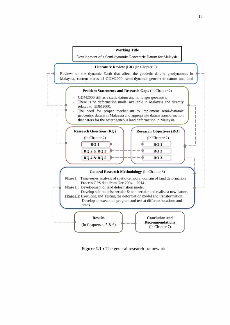
1.7 General Research Framework
This section provides the general research methodology that links to several
key elements of the research such as problem statements, research questions, and
research objectives. Figure 1.1 illustrates the general research framework. The
research framework is essential in order to give an overview of how to construct this
study. Beginning with literature reviews, several aspects in the study have been
reviewed. These include reviews on the dynamic Earth and how it affects the
geodetic datum, geodynamics in Malaysia, current status of GDM2000, semi-
dynamic geocentric datum and land deformation model. From the literature reviews,
it would help to identify the problem statements and research gaps.
Subsequently, 5 research questions and 3 objectives have been derived based
on the problem statements and research gaps. These research questions (RQ) have
specific relation to the objectives, for example RQ 1 will be answered in the first
objective. Then, the research methodology of this study was constructed into three
main phases according to three objectives. On the other hand, specific methods and
techniques were selected by referring back to the information obtained from the
literature reviews. Several assessments on the deformation model have been carried
out and the results were presented accordingly. Lastly, conclusion and
recommendations were outlined at the end of this thesis. Note that the detailed
research framework is illustrated in Figure 3.1, in Chapter 3.
11
Figure 1.1 : The general research framework
Working Title
Development of a Semi-dynamic Geocentric Datum for Malaysia
Literature Review (LR) (In Chapter 2)
Reviews on the dynamic Earth that affect the geodetic datum, geodynamics in
Malaysia, current status of GDM2000, semi-dynamic geocentric datum and land
deformation model.
Problem Statements and Research Gaps (In Chapter 2)
- GDM2000 still as a static datum and no longer geocentric
- There is no deformation model available in Malaysia and directly
related to GDM2000.
- The need for proper mechanism to implement semi-dynamic
geocentric datum in Malaysia and appropriate datum transformation
that caters for the heterogeneous land deformation in Malaysia.
General Research Methodology (In Chapter 3)
Phase I: Time-series analysis of spatio-temporal domain of land deformation.
Process GPS data from Dec 2004 – 2014.
Phase II: Development of land deformation model
Develop sub-models: secular & non-secular and realise a new datum.
Phase III: Executing and Testing the deformation model and transformation.
Develop an execution program and test at different locations and
times.
Research Questions (RQ)
(In Chapter 2)
RQ 1
RQ 2 & RQ 3
RQ 4 & RQ 5
Research Objectives (RO)
(In Chapter 2)
RO 1
RO 2
RO 3
Results
(In Chapters 4, 5 & 6)
Conclusion and
Recommendations
(In Chapter 7)
12
1.8 Thesis Outline
The contents of this thesis is structured into 7 chapters. Chapter 1 describes
the background of the research that consists of the overview of the dynamic Earth
and geocentric datum, problem statements, research gaps, research questions,
research objectives, research scope, significance of research, and research
framework.
Chapter 2 reviews several significant aspects that are related to this study.
The overview of the dynamic Earth in the perspective of Geodesy focuses on
identifying the secular and non-secular motion factors that affect the geodetic datum.
Besides, previous geodynamic studies in Malaysia were also reviewed. Then, the
fundamental geodetic reference systems, frames and datum theory were described as
the working title is mainly related to these topics. Next, the current deformation trend
in Malaysia is described based on previous studies and the accuracy of GDM2000
with relation to the tectonic motion is evaluated in a preliminary study. Lastly, a
review on the semi-dynamic geocentric datum was conducted to take into account
possible techniques to develop a deformation model as well as several considerations
and issues regarding the semi-dynamic geocentric datum. This significantly helps to
answer research question 2.
Chapter 3 provides the research methodology of this study in order to achieve
the research objectives. Three main phases are structured with their respective
procedures. Initially, research materials and tools that consist of information about
the GPS data and software used are outlined. Then, the details on the procedures
begins with data acquisition, followed by data processing, plotting time-series of
MyRTKnet stations and velocities estimation, datum realization, development of
deformation model and lastly the execution and testing of the deformation model and
datum transformation approach.
13
Chapter 4 presents the results and analysis of land deformation in Malaysia
that are significant to achieve the first objective of this study. Initially, the results of
GPS data processing was revealed in order to check the quality of the long-term data
processing. Then, a number of selected time series plots of MyRTKnet and MASS
stations position were presented and the epoch and period of seismic activities are
identified. The time series was then plotted again according to the identified period
of seismic activity. This is to estimate the horizontal velocity and land displacement
that is beneficial for developing the deformation model in the next chapter.
Chapter 5 discusses one of the contributions of this study, i.e., development
of the deformation model based on secular and non-secular land deformation in
Malaysia. This model was developed using three different deformation modules
which are linear least square regression method, displacement offset and second
degree of polynomial. This chapter also presents the results and discusses on each
sub-models that has been developed with regard to the secular and non-secular
motions in Malaysia. In addition, results for the new datum realization of GDM2000
[@2009.3055] and the datum transformation, i.e. geographic offset, to the existing
GDM2000 were indicated.
Chapter 6 contains the framework for implementing a semi-dynamic
geocentric datum in Malaysia. Firstly, a timeline for implementing the semi-dynamic
geocentric datum in Malaysia was illustrated in order to give an understanding of
applying the deformation model as well as geographic offsets involved in the semi-
dynamic geocentric datum. Secondly, the development of execution program for
velocity estimation and coordinate propagation was described. Then, the results from
the assessment of the deformation model were revealed and validated. Lastly, the
implication of implementing a semi-dynamic geocentric datum in Malaysia was
discussed.
Chapter 7 summarises several factors that drive this study and concludes the
major findings from Chapters 4, 5 and 6. Several recommendations are also outlined
for future research.
REFERENCES
Altamimi, Z., Angermann, D., Argus, D., Blewitt, G., Boucher, C., Chao, B., Drewes,
H., Eanes, R., Feissel, M., Ferland, R., Herring, T., Holt, B., Johannson, J.,
Larson, K., Ma, C., Manning, J., Meertens, C., Nothnagel, A., Pavlis, E., Petit,
G., Ray, J., Ries, J., Scherneck, H.-G., Sillard, P., Watkins, M. (2001). The
Terrestrial Reference Frame and the Dynamic Earth. Eos, Transactions
American Geophysical Union. 82 (25), .273–279.
Altamimi, Z., Sillard, P. and Boucher, C. (2002). ITRF2000: A New Release of the
International Terrestrial Reference Frame for Earth Science Applications.
Journal of Geophysical Research. 107 (B10). p. ETG 2-1–ETG 2-19.
Altamimi, Z. (2003). ITRF and Co-location Sites. IERS Technical Note No. 33.
Proceedings of the IERS Workshop on Site Co-location. 23 - 24 October.
Matera, Italy.
Altamimi, Z., Collilieux, X., Métivie, L. (2011). ITRF2008: An Improved Solution of
the International Terrestrial Reference Frame. Journal of Geodesy. 85 (8), 457-
473. Springer.
Altamimi, Z., Métivie, L. and Collilieux, X. (2012). ITRF2008 Plate Motion Model.
Journal of Geophysical Research. 117, B07402.
Angermann, D., Manuela, S. and Drewes, H. (2013). Global Terrestrial Reference
Systems and Their Realizations. In: Xu, G. (Ed.). Sciences of Geodesy – II
Innovations and Future Developments. Springer Berlin Heidelberg.
Argus, D. F., R. G. Gordon, and C. DeMets (2011), Geologically Current Motion of
56 Plates Relative to the No‐Net‐Rotation Reference Frame. Geochem.
Geophys. Geosyst. 12, Q11001.
Banerjee, P., Pollitz, F., Nagarajan, B., and Bürgmann, R. (2007). Coseismic Slip
Distribu-tions of the 26 December 2004 Sumatra-Andaman and 28 March 2005
Nias Earthquakes from GPS Static Offsets. Bulletin of the Seismological
Society of America. 97 (1A), 86-102.
211
Beauducel, F. (1997). Okada85.m Matlab Code. Okada: Surface Deformation due to
a Finite Rectangular Source. Mathworks Matlab Central File Exchange.
Retrieved from: http://www.mathworks.com/matlabcentral/fileexchange
/25982-okada-surface-deformation-due-to-a-finite-rectangular-source/
content/okada85.m.
Beavan, J. (2008). Consultancy services for PositioNZonLine, Phase 2 (PONL-02).
GNS Science Consultancy Report 2008/136: 79. GNS Science, Lower Hutt,
New Zealand.
Beavan, J. and G. Blick. (2005). Limitations in the NZGD2000 deformation model.
Dynamic Planet 2005. Proceedings of the International Association of Geodesy
Conference. Cairns, Australia.
Blewitt, G., and Lavallée, D. (2002). Effect of Annual Signals on Geodetic Velocity.
Journal of Geophysical Research: Solid Earth. 107(B7), ETG-9.
Blick, G., Donnelly, N., and Jordan, A. (2009). The Practical Implications and
Limitations of the Introduction of a Semi-Dynamic Datum – a New Zealand
Case Study. In Drewes, H. Geodetic Reference Frames. (pp. 115-120).
Springer Berlin Heidelberg.
Blick, G., and Grant, D. (2010). The Implementation of a Semi-dynamic Datum in
New Zealand – Ten Years On. Proceedings of the FIG Congress 2010. 11-16
April. Sydney, Australia.
Blick, G., Crook, C., Grant, D., and Beavan, J. (2005). Implementation of a Semi-
Dynamic Datum for New Zealand. In Sanso, F. (Ed) A Window on the Future
of Geodesy 128 (pp. 38-43). Sapporo, Japan: Springer Berlin Heidelberg.
Boehm, J., Heinkelmann, R., Schuh, H. (2007). Short Note: A Global Model of
Pressure and Temperature for Geodetic Applications. Journal of Geodesy. 81,
679–683. Springer.
Boucher, C., Altamimi, Z., Sillard, P., Feissel-Vernier, M. (2004). The ITRF2000.
IERS Technical Note No. 31. Verlag des Bundesamtes für Kartographie und
Geodäsie, Frankfurt am Main.
Bastos, L., Bos, M. and Fernandes, R. M. (2010). Deformation and Tectonics:
Contribution of GPS Measurements to Plate Tectonics – Overview and Recent
Developments. In Xu, G. (Ed) Sciences of Geodesy -1 (pp.155-184). Berlin
Heidelberg: Springer-Verlag.
212
Brunini, L, Sanchez, H. Drewes, S. Costa, V. Mackern, W. Martı´nez, W. Seemuller,
and A. da Silva. (2012). Improved Analysis Strategy and Accessibility of the
SIRGAS Reference Frame. In Kenyon, S. et al. (Eds.) Geodesy for Planet
Earth, International Association of Geodesy Symposia 136 (pp. 3-10). Berlin
Heidelberg: Springer-Verlag.
Campbell, D. R. (2001). Keystone Herbivores and their Impact on Vegetation and
Successional Dynamics within the Debris Avalanche Deposit at Mount St.
Helens National Volcanic Monument. Master’s Thesis. University of
Wisconsin-Stevens Point. United State.
Ching, K. and Chen, K. (2015). Tectonic effect for establishing a semidynamic datum
in Southwest Taiwan. Earth, Planets and Space. 67 (207).
Chlieh, M., Avouac, J., Hjorleifsdottir, V., Song, T. A., Ji, C., Sieh, K., Sladen, A.,
Hebert, H., Prawirodirdjo, L., Bock, Y. and Galetzka, J. (2007). Coseismic Slip
and Afterslip of the Great Mw9.15 Sumatra-Andaman Earthquake of 2004.
Bulletin of the Seismological Society of America. 97 (1A), 152-173.
Cohen, J., Cohen, P., Stephen, G., West, L. and Aiken, S. (2003). Applied Multiple
Regression/Correlation Analysis for the Behavioral Sciences. Lawrence
Erlbaum Association, Inc. Publisher. New Jersey. Third edition.
Conrad, C. P., Steinberger. B. and Torsvik, T. H. (2013). Stability of Active Mantle
Upwelling Revealed by Net Characteristics of Plate Tectonics. Nature. 479-
482.
Dach, R., Hugentobler, U., Fridez, P. and Meindl, M. (2007). Bernese GPS Software
Version 5.0. Switzerland: Astronomical Institute, University of Bern.
DeMets, C., Gordon, R.G., Argus, D.F. and Stein, S. (1994). Effect of recent revisions
to the geomagnetic reversal timescale on estimates of current plate motions.
Geophysical Research Letter. 21(20), 2191.
Denys, P., Winefield, R., and Jordan, A. (2007). Incorporating localised deformation
events in dynamic datums. Proceedings of the FIG General Assembly and
Working Week 2007. 13-17 May. Hong Kong.
Department of Survey and Mapping Malaysia (DSMM). (2009). Technical Guide to
the Coordinate Conversion, Datum Transformation and Map Projection.
(PKPUP3-2009 Circular). Kuala Lumpur: DSMM.
Dressler, M. (2009). Art of Surface Interpolation. PhD’s Thesis. Technical University
of Liberec. Czech Republic.
213
Drewes, H. (2009). Reference Systems, Reference Frames, and the Geodetic Datum –
Basic Considerations. In Sideris, M. G., (Ed.) Observing our Changing Earth,
International Association of Geodesy Symposia 133 (pp.1-9). Berlin
Heidelberg: Springer-Verlag.
Drewes, H., and Heidbach, O. (2005). Deformation of the South American Crust
Estimated from Finite Element and Collocation Methods. In Sanso, F. (Ed) A
Window on the Future of Geodesy 128 (pp. 544-549). Sapporo, Japan: Springer
Berlin Heidelberg.
El-Rabbany, A. (2006). Introduction to GPS the Global Positioning System, Second
Edition. Boston, London: Artech House, Inc.
Even-Tzur, G. (2011). Updating the Semi-Dynamic Datum of Israel. Surveying and
Land Information Science, 71 (2). 41-47.
Fortes, L. P., Lauria, E., Brunini, C., Amaya, W., Sanchez, L., Drewes, H., and
Seemüller, W. (2006). Current Status and Future Developments of the SIRGAS
Project. Wissenschaftliche Arbeiten der Fachrichtung Geodäsie und
Geoinformatik der Universität Hannover. 258. 59-70.
Geographical Survey Institute. (2004). The New Geodetic Reference System of Japan
− Its adoption and application to our products. Bulletin of the Geographical
Survey Institute. 50 (March).
Goudarzi, M. A., Cocard, M., Santerre, R. and Woldai, T. (2013). GPS Interactive
Time Series Analysis Software. GPS solutions. 17(4), 595-603.
Grant, D., and Crook, C. (2012). Spatial maintenance of the New Zealand Cadastre in
Response to Earthquakes. Proceedings of the FIG Working Week 2012. 6-10
May. Rome, Italy.
Grand, D. and Blick, G. (1998). A New Geocentric Datum for New Zealand. New
Zealand Surveyor. 288.
Grant, D. and Pearse, M. (1995). Proposal for a Dynamic National Geodetic Datum
for New Zealand. Proceedings of the IUGG XXI General Assembly. 2-14 July.
Colorado, USA.
Gregory, K. J. (2010). The Earth's Land Surface: Landforms and Processes in
Geomorphology. Sage Publications Ltd, Landon.
Haasdyk, J., Donnelly, N., Harrison, C., Rizos, C., Roberts, C., and Stanaway, R.
(2014). Options for Modernising the Geocentric Datum of Australia.
214
Proceedings of the Research@Locate'14 Conference. 7-9 April. Canberra,
Australia.
Hamada, Y., Sakaguchi, A., Tanikawa, W., Yamaguchi, A., Kameda, J. and Kimura,
G. (2015). Estimation of Slip Rate and Fault Displacement during Shallow
Earthquake Rupture in the Nankai Subduction Zone. Earth, Planets and Space.
67(39).
Hambli, W. K. and Christiansen, E. H. (2009). Earth’s Dynamic Systems. Web edition
1.0. Pearson Education, Inc., publishing as Pearson Prentice Hall. Retrieved
from: http://earthds.info/pdfs/EDS_17.PDF.
Hase, H. (2011). Geodesy, Networks and Reference Systems. Encyclopedia of Earth
Sciences Series 2011. 323-331. Encyclopedia of Solid Earth Geophysics.
Springer Science+Business Media B.V.
Hashim, N. M., Omar, A. H., Omar, K. M., Abdullah, N. M. and Yatim, M. H. M.
(2016). Cadastral Positioning Accuracy Improvement: A Case Study in
Malaysia. Proceedings of the Remote Sensing and Spatial Information Sciences
XLII-4/W1. International Conference on Geomatic and Geospatial Technology
(GGT). 3–5 October, Kuala Lumpur, Malaysia.
Hiyama Y., Yamagiwa, A., Kawahara, T., Iwata, M., Fukuzaki, Y., Shouji, Y., Sato,
Y., Yutsudo, T., Sasaki, T., Shigematsu, H., Yamao, H., Inukai, T., Ohtaki, M.,
Kokado, K., Kurihara, S., Kimura, I., Tsutsumi, T., Yahagi, T., Furuya, Y.,
Kageyama, T., Kawamoto, S., Yamaguchi, K., Tsuji, H., and Matsumura, S.
(2011). Revision of Survey Results of Control Points after the 2011 off the
Pacific Coast of Tohoku Earthquake. Bulletin of the GSI. 59.
Hofmann-Wellenhof, B., Lichtenegger, H. and Wasle, E. (2008). GNSS Global
Navigation Satellite Systems GPS, GLONASS, Galileo and more. Austria:
Springer Wien NewYork.
Hu, Y. and Wang, K. (2012). Spherical-Earth Finite Element Model of Short-term
Postseismic Deformation Following the 2004 Sumatra Earthquake. Journal of
Geophysical Research. 117, B05404.
International Association of Geodesy (IAG) (2012). Geodesy for Sustainable
Development. Proceedings of the Nineteenth United Nations Regional
Cartographic Conference for Asia and the Pacific. 29 October – 1 November.
Bangkok.
215
International Committee on Global Navigation Satellite Systems (ICG). (2013).
Retrieved from: http://www.oosa.unvienna.org/pdf/icg/2012/template/
WGS_84.pdf.
Jekeli, C. (2012). Geometric Reference Systems in Geodesy (2nd Ed.). Columbus: The
Ohio State University.
Jhonny. (2010). Post-Seismic Earthquake Deformation Monitoring in Peninsular
Malaysia using Global Positioning System. Master’s Thesis, Universiti
Teknologi Malaysia, Skudai.
Jordan, A., Denys, P., and Blick, G. (2007). Implementing Localised Deformation
Models into a Semi-Dynamic Datum. In Tregoning, P. and Rizos, C. (Eds)
Dynamic Planet: Monitoring and Understanding a Dynamic Planet with
Geodetic and Oceanographic Tools. 130 (pp. 631-637) Cairns, Australia:
Springer Berlin Heidelberg.
Kadir, M., Ses, S., Omar, K., Desa, G., Omar, A.H., Taib, K and Nordin, S. (2003).
Geocentric Datum GDM2000 for Malaysia: Implementation and Implications.
Seminar on GDM2000, Department of Survey & Mapping Malaysia. 28
August, Kuala Lumpur, Malaysia.
Kelly, K. M. (2012). Towards implementing dynamic datum data management in GIS.
Proceedings of FIG Working Week 2012. 6-10 May. Rome, Italy.
Kious, W. J., and Tilling, R. I. (2008). This Dynamic Earth: The story of plate
tectonics: Online Edition (1.15th Ed.). U.S Geological Survey. Retrieved from
http://pubs.usgs.gov/gip/dynamic/dynamic.html.
Li, B., and Teunissen, P. J. (2011). High dimensional integer ambiguity resolution: a
first comparison between LAMBDA and Bernese. Journal of Navigation.
64(S1), S192-S210.
Malys, S., Slater, J.A., Smith, R.W., Kunz, L.E. and Kenyon, S.C. (1997). Refinements
to the World Geodetic System 1984, Proceedings of the ION GPS-97. 16-19
September, Kansas City, MO, 841-850.
McCarthy, D., and G. Petit (2004). IERS Conventions 2003. IERS Technical Note 32.
Verlag des Bundesamts für Kartographie und Geodäsie, Frankfurt am Main,
Germany.
Mccaffrey, R. (2002). Crustal Block Rotations and Plate Coupling, In Plate Boundary
Zones. American Geophysical Union. 101-122.
216
Merrigan, M. J., Swift, E. R., Wong, R. F. and Saffel, J. T. (2002). A Refinement to
the World Geodetic System 1984 Reference Frame. Proceedings of the
Institute of Navigation, ION – GPS. 24-27 September. Portland, Oregon, 1519-
1529.
Michel, G. W., Yua, Y. Q., Zhua, S. Y., Reigber, C., Becker, M., Reinhart, E., Simons,
W., Ambrosius, B., Vigny, C., Chamot-Rooke, N., Pichond, X., Morgane, P.
and Matheussene, S. (2001). Crustal Motion and Block Behaviour in SE-Asia
from GPS Measurements. Earth and Planetary Science Letters. 187 (3-4), 239-
244. Elsevier.
Milne, G. A., Davis, J. L., Mitrovica, J. X., Scherneck, H.-G., Johansson, J. M.,
Vermeer, M., & Koivula, H., 2001. Space-geodetic Constraints on Glacial
Isostatic Adjustment in Fennoscandia. Science. 291 (5512), 2381-2385.
American Association for the Advancement of Science.
Nishimura, T. (2014). Short-Term Slow Slip Events along the Ryukyu Trench,
Southwestern Japan, observed by Continuous GNSS. Progress in Earth and
Planetary Science. 1 (12).
Okada, Y. (1985). Surface deformation due to shear and tensile faults in a half-space,
Bulletin Seism. Soc. Am. 75. 1135–1154.
Okada, Y. (1992). Internal Deformation Due To Shear and Tensile Faults in a Half-
Space. Bulletin of the Seismological Society of America. 82, 1018–1040.
Omar, K. and Nordin, S. (2000). Geodetic Practices in Malaysia. Skudai, Malaysia:
UTM Publisher.
Omar, K. and Jhonny (2009). Crustal Deformation Study in Peninsula Malaysia using
Global Positioning System. Proceedings of Postgraduate Seminar Faculty of
Geoinformation Science & Engineering. 14-15 July. Institut Ibnu Sina UTM,
Skudai.
Pearson, C., McCaffrey, R., Elliott, J. L., and Snay, R. (2010). HTDP 3.0: Software
for Coping with the Coordinate Changes Associated with Crustal Motion.
Journal of Surveying Engineering. 136 (2), 80-90.
Pearson, C., and Snay, R. (2013). Introducing HTDP 3.1 to transform coordinates
across time and spatial reference frames. GPS Solutions. 17 (1), 1-15.
Peltier, W. R. (2004). Global Glacial Isostasy and the Surface of the Ice-Age Earth:
The ICE-5G (VM2) Model and GRACE. Annu. Rev. Earth Planet Sci. 32, 1 1
1-149. Annual Reviews.
217
Petit, G. and Luzum, B. (2010). IERS Conventions (2010). IERS Technical Note 36.
Verlagdes Bundesamts für Kartographie und Geodäsie, Frankfurt am Main,
Germany.
Pinto, J. T. (2009). Questioning the Need of Regional Reference Frames. In Drewes,
H. (Ed) Proceedings of the Geodetic Reference Frame, International
Association of Geodesy Symposia vol 134. (pp. 225–230). Berlin: Springer.
Plag, H-P. (2006). National Geodetic Infrastructure Current Status and Future
Requirements: The Example of Norway. Nevada Bureau of Mines and Geology
Bulletin 112, University of Nevada.
Plag, H.-P., Altamimi, Z., Bettadpur, S., Beutler, G., Beyerle, G., Cazenave, A.,
Crossley, D., Donnellan, A., Forsberg, R., Gross, R., Hinderer, J., Komjathy,
A., Ma, C., Mannucci, A.J., Noll, C., Nothnagel, A., Pavlis, E.C., Pearlman,
M., Poli, P., Schreiber, U., Senior, K., Woodworth, P.L., Zerbini, S., Zuffada,
C. (2009). The Goals, Achievements, and Tools of Modern Geodesy. In Plag,
H.-P. and Pearlman, M. (Eds) Global Geodetic Observing System (pp. 15-88).
Berlin: Springer-Verlag.
Ray, J., Dong, D. and Altamimi, Z. (2004). IGS Reference Frames: Status and Future
Improvements. Proceedings of the Workshop and Symposium “Celebrating a
Decade of the International GPS Service”. Astronomical Institute, University
of Bern, Switzerland.
Rebischung, P., Griffiths, J., Ray, J., Schmid, R., Collilieux, X., and Garayt, B. (2012).
IGS08: the IGS realization of ITRF2008. GPS solutions. 16(4), 483-494.
Riley, W. J. (2008). Algorithms for Frequency Jump Detection. Metrologia. 45, S154–
S161. IOP Publishing.
Rodionov, S., N. (2004). A Sequential Algorithm for Testing Climate Regime Shifts.
Geophys. Res. Lett. 31, L09204.
Rummel, R. (2010). The Interdisciplinary Role of Space Geodesy-Revisited. Journal
of Geodynamics. 49, 112–115. Elsevier.
Rummel, R., Beutler, G., Dehant, V., Gross, R., Ilk, K. H., Plag, H.-P., Poli, P.,
Rothacher, M., Stein, S., Thomas, R., Woodworth, P. L., Zerbini, S. and
Zlotnicki, V. (2009). Understanding a Dynamic Planet: Earth Science
Requirements for Geodesy. In Plag, H.-P. and Pearlman, M. (Eds) Global
Geodetic Observing System (pp. 15-88). Berlin: Springer-Verlag.
218
Sánchez, L. (2011). IGS Regional Network Associate Analysis Center for SIRGAS
(IGS RNAAC SIR). IGS Technical Report. 107-115.
Satirapod, C., Wicheancharoen, C., Trisirisatayawonga, I., Vigny, C. and Simons, W.
(2005). Surface Displacement due to Banda-Aceh Earthquake and its Effect on
Geo-Informatic Work in Thailand. Proceedings of IEEE IGARSS 2005. Seoul,
Korea, 2907-2909.
Seeber, G. (2003). Satellite Geodesy. 2nd Edition. Walter de Gruyter GmbH & Co.
Berlin New York.
Seitz, M., Angermann, D., Gerstl, M., Bloßfeld, M., Sánchez, L. and Seitz, F. (2015).
Geometrical Reference Systems. In Freeden, W., Nashed, M. Z. and Sonar, T.
(Eds.) Handbook of Geomathematics (Second Edition), Springer.
Schmid R, Steigenberger P, Gendt G, GeM, Rothacher M. (2007). Generation of a
Consistent Absolute Phase-Center Correction Model for GPS Receiver and
Satellite Antennas. Journal of Geodesy. 81, 781–798.
Simons, W., Socquet, A., Vigny, C., Ambrosius, C., Abu, S., Promthong, C., Subarya,
C., Sarsito, D. A, Matheussen, S., Morgan, P. and Spakman, W. (2007). A
Decade of GPS in Southeast Asia: Resolving Sundaland Motion and
Boundaries. Journal of Geophysical Research. 112 (B06420). AGU
Publications.
Smith, P. and Wessel, W. H. (1990). Gridding with Continuous Curvature Splines in
Tension. Geophysics. 55 (3), 293-305.
Socquet, A., Vigny, C., Chamot-Rooke, N., Simons, W., Rangin, C. and Ambrosius,
B. (2006). India and Sunda Plates Motion and Deformation along their
Boundary in Myanmar Determined by GPS. Journal of Geophysical Research.
111 (B05406). AGU Publications.
Soffel, M. and Langhans, R. (2012). Space-Time Reference Systems. Springer
Heidelberg New York Dordrecht London.
Stanaway, R. F. (2004). Implementation of a Dynamic Geodetic Datum in Papua New
Guinea: A Case Study. MPhil Thesis. The Australian National University,
Australia.
Stanaway, R., Roberts, C., Blick, G. and Crook, C. (2012). Four Dimensional
Deformation Modelling, the link between International, Regional and Local
Reference Frames. Proceedings of the FIG Working Week 2012. 6-10 May.
Rome, Italy.
219
Stanaway, R., Roberts, C., and Blick, G. (2014). Realisation of a Geodetic Datum
Using a Gridded Absolute Deformation Model (ADM). In Rizos, C. and Willis,
P. Earth on the Edge: Science for a Sustainable Planet. Melbourne, 139 (pp.
259-265). Australia: Springer Berlin Heidelberg.
Steinberg, G., and Even-Tzur, G. 2005. Establishment of National Grid Based on
Permanent GPS Stations in Israel. Surveying and Land Information Science. 65
(1), 47-52.
Susilo, S., Abidin, H., Z., Meilano, I. and Sapiie, B. (2015). On the Development and
Implementations of the New Semi-Dynamic Datum for Indonesia. Proceedings
of the FIG Working Week 2015. 17-21 May. Sofia, Bulgaria.
Takasu, T. (2009). GPS Precise Analysis Software GpsTools: Program Execution.
http://gpspp.sakura.ne.jp/gpstools/help/gpstools1.htm.
Tanaka, Y., Saita, H., Sugawara, J., Iwata, K., Toyoda, T., Hirai, H., Kawaguchi, T.,
Matsuzaka, S., Hatanaka, Y., Tobita, M., Kuroishi, Y., and Imakiire, T. (2007).
Efficient Maintenance of the Japanese Geodetic Datum 2000 using Crustal
Deformation Models-Patch JGD & Semi-Dynamic Datum. Buletin Geog Surv
Inst. 54.
Tregoning, P., McQueen, H., Lambeck, K., Jackson, R., Little, R., Saunders, S. and
Rosa, R. (2000). Present-day Crustal Motion in Papua New Guinea. Earth,
Planets and Space. 52 (10), 727-730. Springer.
Tregoning, P. and van Dam, T. (2005). Effects of Atmospheric Pressure Loading and
Seven-Parameter Transformations on Estimates of Geocenter Motion and
Station Heights from Space Geodetic Observations. Journal of Geophysical
Research. 110 (B03408). AGU Publications.
True, S. A. (2004). Planning the Future of the World Geodetic System 1984.
Proceedings of the IEEE PLANS 2004. 26-29 April. Monterey, CA, 639-468.
Tsang, L. L. H., Meltzner, A. J., Philibosian, B., Hill, E. M., Freymueller, J. T., Seih,
K.. 2015. A 15 Year Slow-Slip Event on the Sunda Megathrust offshore
Sumatra. Geophysical Research Letters. 42 (16).
Van Dam, T., Blewitt, G. and Heflin, M. B. (1994). Atmospheric Pressure Loading
Effects on Global Positioning System Coordinate Determinations. Journal of
Geophysical Research: Solid Earth. 99 (B12), 23939–23950. AGU
Publications.
220
Van Dam, T., Altamimi, Z., Collilieux, X. and Ray, J. (2010). Topographically
Induced Height Errors in Predicted Atmospheric Loading Effects. Journal of
Geophysical Research. 115 (B07415). AGU Publications.
Vigny, C., Simons, W. J. F., Abu, S. H., Ronnachai, B., Satirapod, C., Chhoosakul,
M., Subarya, C., Omar, K., Abidin, H. Z., Socquet, A. and Ambrosius, B. A.
C., (2005). Insight into the 2004 Sumatra–Andaman earthquake from GPS
measurements in Southeast Asia. Nature. 436, 201–206.
Weber, J. C., Dixon, T. H., DeMets, C., Ambeh, W. B., Mattioli, P. J. G., Saleh, J.,
Sella, G., Bilham, R. and Perez, O. (2001). GPS Estimate of Relative Motion
between the Caribbean and South American Plates, and Geologic Implications
for Trinidad and Venezuela. Geology. 29 (1), 75-78. Geological Society of
America.
Weisstein, E. W. (2015). Least Squares Fitting. Retrieved from
http://mathworld.wolfram.com/LeastSquaresFitting.html.
Wessel, P. and Smith, W. H. (2016). The Generic Mapping Tools GMT version 4.5.15
Technical Reference and Cookbook. School of Ocean and Earth Science and
Technology University of Hawai’i at Manoa.
Wang, K., Hu, Y. and He, J. (2012). Deformation Cycles of Subduction Earthquakes
in a Viscoelastic Earth. Nature. 484, 327-332. Macmillan Publishers Limited.
Wijaya, D. D., Böhm, J., Karbon, M., Krásná, H. and Schuh, H. Atmospheric Pressure
Loading. In Böhm, J. and Schuh, H. (Eds.) Atmospheric Effects in Space
Geodesy (pp. 137-157). Berlin Heidelberg: Springer Verlag.


