27
SERVIR-AFRICA: an overview André Kooiman International workshop on higher resolution Land cover mapping for the African continent UNEP, 27 June 2013
| Date post: | 28-Dec-2015 |
| Category: |
Documents |
| Upload: | hubert-rogers |
| View: | 216 times |
| Download: | 0 times |

SERVIR-AFRICA:an overview
André Kooiman
International workshop on higher resolutionLand cover mapping for the African continentUNEP, 27 June 2013

AIMS
Improve resilience to climate change and related environmental management and disaster risk management
by
Strengthening the capacity of governments and other key stakeholders to integrate earth observation and geospatial technologies into decision-making.

What is SERVIR-Africa?

Click to edit Master title styleSERVIR Africa activity structure

SERVIR ONE-STOP

GEODATABASE

WEB PORTAL
SERVIRglobal.net: an online “one-stop shop” for geospatial information.
Includes:
1. Data catalog
2. Web mapping and visualization tools
3. Online geospatial data feeds from a variety of sources
4. Customized applications
5. Training materials
6. Knowledge base: info on projects, success stories, news from the
user community

WEB PAGES

TOOLS

Click to edit Master title styleInteractive mapper
• SERVIR Interactive Mapper displaying a land cover map for 2008 derived from MODIS imagery

CLIP, ZIP, SHIP TOOLDownload data from SERVIR Geospatial One Stop: select layers of interest, give email address, specify AOI and an email with the download link will be sent: http://servir.rcmrd.org/geoapps/ecosystems/

BIODIVERSITY TOOLS• Shows spatial distribution of selected species in Kenya and neighboring countries based
on the National Museums Kenya occurrence data: http://servir.rcmrd.org/geoapps/biodiversity/

Frost monitoring and early warning
• In Kenya, as with many other countries in Africa, frost damages are a significant threat to agriculture.
• Using satellite datasets, SERVIR has put together a system for early detection of frost and for damaged area assessment. Next phases will include near real time temperature observations and forecasts of frost areas.
• This information is in high demand from agricultural insurance companies and farmers and is shared with these

FLOODING: ‘CREST’ STREAM FLOW PREDICTION MODEL
• SERVIR-Africa has been running a water resource assessment tool, a distributed hydrologic model called CREST, for a large domain in East Africa using NASA remotely sensed datasets.
• The purpose of the modeling effort is to empower the decision makers with timely information about the water resources conditions. SERVIR-Africa has engaged the Ministry of Water Resources in Kenya and is reaching out to other countries.
• SERVIR-Africa has generated historic hydrologic model runs, is running the model in near real time and is working on getting the seasonal forecasts in a few months.

Streamflow using TRMM data

GIS FLOOD TOOLS GFT ArcMap extension analyzing flood extend using DEM and discharge value

Mobile applications
Mobile phones are everywhere in Africa. In Kenya, in fact there are 74 mobile phones for every 100 and nearly 99% of the internet subscriptions are on mobile phones! SERVIR works on text based alerting systems and on smartphone applications.

The Adaptation
SERVIR has adapted CREST model products to fit the mobile needs.
CREST Models can runOn all iOS and Android devices.

Linking project data and external web services
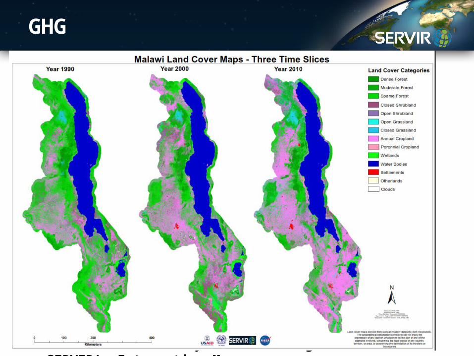
GHG
The same food security outlook integrated in SERVIR's Interactive Mapper

GEONODE
The same outlook as Worldbank Geonode integrated in SERVIR's Interactive Mapper

WAY FORWARD

Bridging science with user needs

In a changing world..


1. Build bridges to users;2. From ad hoc projects to long term data access;3. From scattered data availability to one stop;4. From snapshots to monitoring;5. From small scale to large scale;6. To data sharing and open data;7. To smart dissemination of spatial tools.
CONCLUSIONS


