+ All Categories
Home > Documents > Session 11-2 Land use statistics (FAO) - United Nations · • Reduce the rate of deforestation?...

Session 11-2 Land use statistics (FAO) - United Nations · • Reduce the rate of deforestation?...

Date post: 30-Apr-2020
Category:
Upload: others
View: 3 times
Download: 0 times
Share this document with a friend
47
Statistics on land use NAME1 NAME2 CODE ITEM_CODE YEAR ELEMENT_CO DATA COMMENTS Region 1 Ariana TUN001001 44 1994 031 2100 Region 1 Ben Arous (Tunis Sud) TUN001002 44 1994 031 1700 Region 1 Tunis TUN001003 44 1994 031 300 Region 2 Bizerte TUN002001 44 1994 031 6000 Region 2 Nabul TUN002002 44 1994 031 17300 Region 2 Saghuan Region 1 Ariana TUN001001 44 1994 051 1900 Region 1 Ben Arous (Tunis Sud) TUN001002 44 1994 051 1500 Region 1 Tunis TUN001003 44 1994 051 400 Region 2 Bizerte TUN002001 44 1994 051 5400 Region 2 Nabul TUN002002 44 1994 051 18600 Region 2 Saghuan TUN002003 44 1994 051 3400 NAME1 NAME2 CODE ITEM_CODE YEAR ELEMENT_CO DATA COMMENTS Region 1 Ariana TUN001001 44 1994 031 2100 Region 1 Ben Arous (Tunis Sud) TUN001002 44 1994 031 1700 Region 1 Tunis TUN001003 44 1994 031 300 Region 2 Bizerte TUN002001 44 1994 031 6000 Region 2 Nabul TUN002002 44 1994 031 17300 Region 2 Saghuan TUN002003 44 1994 031 2800 Region 1 Ariana TUN001001 44 1994 051 1900 Region 1 Ben Arous (Tunis Sud) TUN001002 44 1994 051 1500 Region 1 Tunis TUN001003 44 1994 051 400 Region 2 Bizerte TUN002001 44 1994 051 5400 Region 2 Nabul TUN002002 44 1994 051 18600 Region 2 Saghuan TUN002003 44 1994 051 3400 Land and Plant Nutrition Management Service, AGLL Land and Water Development Division FAO Hubert George NAME1 NAME2 CODE ITEM_CODE YEAR ELEMENT_CO DATA COMMENTS Region 1 Ariana TUN001001 44 1994 031 2100 Region 1 Ben Arous (Tunis Sud) TUN001002 44 1994 031 1700 Region 1 Tunis TUN001003 44 1994 031 300 Region 2 Bizerte TUN002001 44 1994 031 6000 Region 2 Nabul TUN002002 44 1994 031 17300 Region 2 Saghuan TUN002003 44 1994 031 2800 Region 1 Ariana TUN001001 44 1994 051 1900 Region 1 Ben Arous (Tunis Sud) TUN001002 44 1994 051 1500 Region 1 Tunis TUN001003 44 1994 051 400 Region 2 Bizerte TUN002001 44 1994 051 5400 Region 2 Nabul TUN002002 44 1994 051 18600 Region 2 Saghuan TUN002003 44 1994 051 3400 FOOD AND AGRICULTURE FOOD AND AGRICULTURE ORGANIZATION ORGANIZATION OF THE UNITED NATIONS OF THE UNITED NATIONS
Transcript

Statistics on land useNAME1 NAME2 CODE ITEM_CODE YEAR ELEMENT_CO DATA COMMENTSRegion 1 Ariana TUN001001 44 1994 031 2100Region 1 Ben Arous (Tunis Sud) TUN001002 44 1994 031 1700Region 1 Tunis TUN001003 44 1994 031 300Region 2 Bizerte TUN002001 44 1994 031 6000Region 2 Nabul TUN002002 44 1994 031 17300Region 2 Saghuan TUN002003 44 1994 031 2800Region 1 Ariana TUN001001 44 1994 051 1900Region 1 Ben Arous (Tunis Sud) TUN001002 44 1994 051 1500Region 1 Tunis TUN001003 44 1994 051 400Region 2 Bizerte TUN002001 44 1994 051 5400Region 2 Nabul TUN002002 44 1994 051 18600Region 2 Saghuan TUN002003 44 1994 051 3400

NAME1 NAME2 CODE ITEM_CODE YEAR ELEMENT_CO DATA COMMENTSRegion 1 Ariana TUN001001 44 1994 031 2100Region 1 Ben Arous (Tunis Sud) TUN001002 44 1994 031 1700Region 1 Tunis TUN001003 44 1994 031 300Region 2 Bizerte TUN002001 44 1994 031 6000Region 2 Nabul TUN002002 44 1994 031 17300Region 2 Saghuan TUN002003 44 1994 031 2800Region 1 Ariana TUN001001 44 1994 051 1900Region 1 Ben Arous (Tunis Sud) TUN001002 44 1994 051 1500Region 1 Tunis TUN001003 44 1994 051 400Region 2 Bizerte TUN002001 44 1994 051 5400Region 2 Nabul TUN002002 44 1994 051 18600Region 2 Saghuan TUN002003 44 1994 051 3400

Land and Plant Nutrition Management Service, AGLLLand and Water Development Division

FAO

Hubert George

NAME1 NAME2 CODE ITEM_CODE YEAR ELEMENT_CO DATA COMMENTSRegion 1 Ariana TUN001001 44 1994 031 2100Region 1 Ben Arous (Tunis Sud) TUN001002 44 1994 031 1700Region 1 Tunis TUN001003 44 1994 031 300Region 2 Bizerte TUN002001 44 1994 031 6000Region 2 Nabul TUN002002 44 1994 031 17300Region 2 Saghuan TUN002003 44 1994 031 2800Region 1 Ariana TUN001001 44 1994 051 1900Region 1 Ben Arous (Tunis Sud) TUN001002 44 1994 051 1500Region 1 Tunis TUN001003 44 1994 051 400Region 2 Bizerte TUN002001 44 1994 051 5400Region 2 Nabul TUN002002 44 1994 051 18600Region 2 Saghuan TUN002003 44 1994 051 3400

FOOD AND AGRICULTURE FOOD AND AGRICULTURE ORGANIZATION ORGANIZATION OF THE UNITED NATIONSOF THE UNITED NATIONS

• Environmental & policy issues• Sources of land use & land cover statistics

– the institutional aspects• Concepts, methods & classifications• The UNSD questionnaire on land use statistics &

linkages with other statistics • The Agro-MAPS initiative

Outline

Setting the scope:Environmental & Policy Issues

Land resources• the near-surface climate, • the soil and terrain forms, • the surface hydrology

(including shallow lakes, rivers, marshes and swamps),

• the near surface sedimentary layers and associated groundwater and geo-hydrological reserve,

• the plant and animal populations,

• the human settlements pattern and physical results of past and present human activities” FAO, 1995

Total land area Total area of a country, minus area under major inland/tidal water bodies.

...a delineable area of the earth's terrestrial surface, encompassing all attributes of the biosphere immediately above or below this surface --

“..human activities which are directly related to land, making use of its resources or having an impact on it ...”FAO, 1995

Land use

• Socio-economic purpose of the activities (functional definition)• Usually multiple purposes• Manipulation of natural ecosystems in order to obtain benefits• Material benefits/ products (e.g. cereals, livestock)• Immaterial benefits/ services (e.g. erosion prevention)• Often some unwanted impacts!!

Management OutputsInputsWhat is the land used for?production vs. extractive process

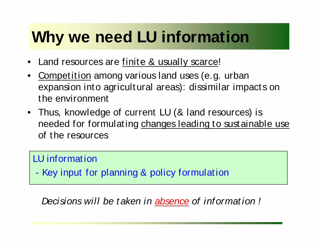
• Land resources are finite & usually scarce!• Competition among various land uses (e.g. urban

expansion into agricultural areas): dissimilar impacts on the environment

• Thus, knowledge of current LU (& land resources) is needed for formulating changes leading to sustainable useof the resources

Why we need LU information

LU information - Key input for planning & policy formulation

Decisions will be taken in absence of information !

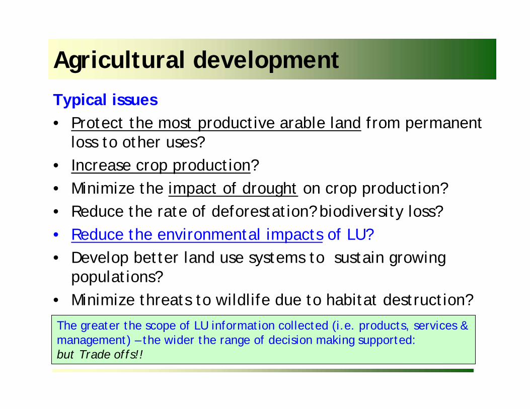
Typical issues• Protect the most productive arable land from permanent

loss to other uses?• Increase crop production?• Minimize the impact of drought on crop production?• Reduce the rate of deforestation? biodiversity loss?• Reduce the environmental impacts of LU?• Develop better land use systems to sustain growing

populations?• Minimize threats to wildlife due to habitat destruction?

Agricultural development

The greater the scope of LU information collected (i.e. products, services & management) – the wider the range of decision making supported: but Trade offs!!

●Impact of drought on agricultural production

●●●Remedial measures to counter

inappropriate land management

●●●Areas at risk to land degradation

●●●Land evaluation for agriculture

●●●Threats to wildlife due to habitat

destruction

●●Pollution caused by use of fertilizers/

pesticides

●Impact of loss of agricultural land on

production

Mgmt.ServicesGoods

Required LU dataExamples of Issues

Scope of LU information to collect

Arable Land: a finite resource

6052East Asia excluding China

6563East Asia

9894South Asia2319Latin America & Caribbean

9487Near East/ North Africa

2822Sub-Saharan Africa

20301997/99Region

Arable land in use as % of potentially arable land

Source: FAO. World Agriculture: towards 2015/2030

Expansion of arable land to support growing populations comes atexpense of other land uses (e.g. forestry)

1977 1987

19901972Riyadh

Tehran

Competition for land

Source: EROS Land characteristics database

Land cover: sub Saharan Africa

... a component of the natural resources base

... the observed (bio)physical cover on the earth’s surface (LCCS, 2000)

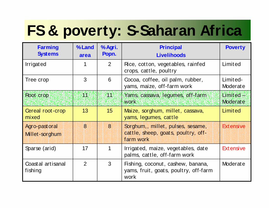
Farming systems: 2001 global study

SourceAnalysis of human livelihoods & poverty

Similar

•resource base

•enterprise (activity) patterns

•household livelihoods & constraints

FS & poverty: S-Saharan Africa

Fishing, coconut, cashew, banana, yams, fruit, goats, poultry, off-farm work

Irrigated, maize, vegetables, date palms, cattle, off-farm work

Sorghum,, millet, pulses, sesame, cattle, sheep, goats, poultry, off-farm work

Maize, sorghum, millet, cassava, yams, legumes, cattle

Yams, cassava, legumes, off-farm work

Cocoa, coffee, oil palm, rubber, yams, maize, off-farm work

Rice, cotton, vegetables, rainfedcrops, cattle, poultry

PrincipalLivelihoods

Moderate32Coastal artisanalfishing

Extensive117Sparse (arid)

Extensive88Agro-pastoralMillet-sorghum

Limited1513Cereal root-crop mixed

Limited –Moderate

1111Root crop

Limited-Moderate

63Tree crop

Limited21Irrigated

Poverty% Agri. Popn.

% Land area

FarmingSystems

Environmental conventions• The Convention on Wetlands (Ramsar Convention), 1971

– Programs to conserve and use wisely all wetlands; 137 Parties;

• Convention on International Trade in Endangered Species of Wild Fauna and Flora, CITES 1975– To safeguard species from over exploitation; 164 parties; Appropriate wildlife

management & trade policies

• Convention on Biological Diversity, CBD 1992– 187 Parties; biodiversity conservation

• UN Framework Convention on Climate Change, 1992• Kyoto Protocol (joint implementation, CDM, emissions

trading)• UN Convention to Combat Desertification, UNCCD, 1994

– Programs to reduce degradation of land in arid, semi-arid and dry sub-humid areas; 166 Parties;

●●●

Long-term cultivated; improved pasture, unimproved pasture, new set aside, old set aside, wetland/paddy, shifting agriculture, abandoned/ degraded

●●●Cropland/ grazing land management;

●●Other land

●●Settlements (villages, urban)

●●Wetland

●●●Pasture (improved grassland)

●●●Cropland

●●●Forest & wooded land (managed)

●●Forest & wooded land (unmanaged)

Mgmt.ServicesGoods

Required LU dataSelected information requirements UNFCC, Kyoto Protocol

Scope of LU information to collect

Sources of land use & land cover statistics:

the institutional aspect

• Land use – socio-economic purpose (inputs, management & outputs)

• Land cover – biophysical cover of land (forests, shrubs, soils, rock, wetland ..)

• closely related but dissimilar terms!!– livestock grazing in different LC types– a forest supporting multiple LU -- e.g. shifting

agriculture, timber production, hunting, livestock grazing (60% in India) ..

• LU/LC supports a wide range of decision making

Sources of LU & LC statistics I

..data collection by several different government depts. (e.g. forestry, agriculture, livestock, fisheries,..)!!

Sources of LU & LC statistics II

Waters

Open land

Built-up & related land

Forest & other wooded land

Agricultural land

LC

n.e.s (with no vegtn)

Dry (with special vegtn. <2m)

Wet (no vegtn.)LC

LU

LC

LU

Department of FisheriesMinistry of Natural Resources

Ministry of Natural Resources

Urban & regional Planning

Department of Forests

Ministry of Agriculture

...indicative only!!UNSD questionnaire

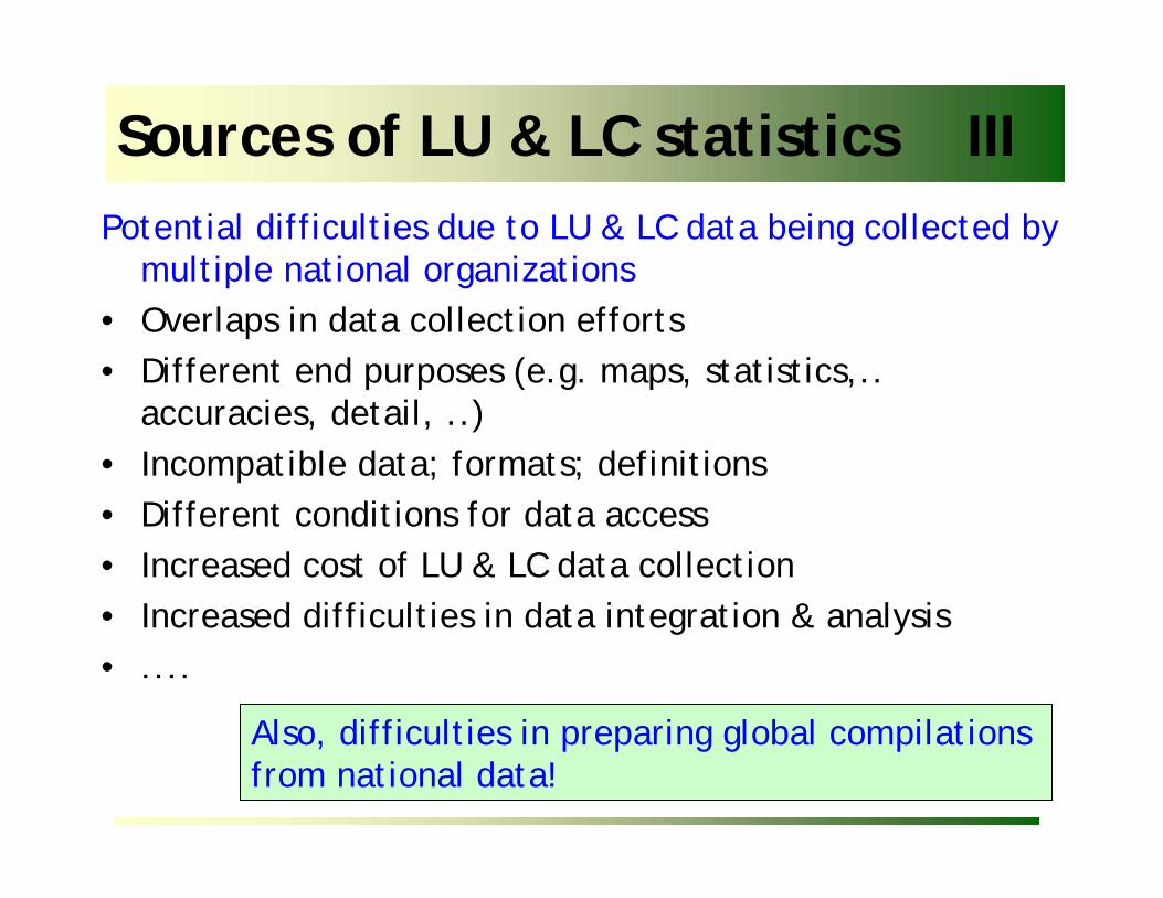
Potential difficulties due to LU & LC data being collected by multiple national organizations

• Overlaps in data collection efforts• Different end purposes (e.g. maps, statistics,..

accuracies, detail, ..)• Incompatible data; formats; definitions• Different conditions for data access• Increased cost of LU & LC data collection• Increased difficulties in data integration & analysis• ....

Sources of LU & LC statistics III

Also, difficulties in preparing global compilations from national data!

Sources of LU & LC statistics IV

Overcoming difficulties to LU & LC data being collected by

multiple national organizations

• Set up mechanism for coordination• Rationalize data collection efforts (who does what)

taking present & future needs into account• Review relevant mandates/ legislation• Adopt common technical standards (SDI initiatives)• Develop protocols for data access/ sharing/ distribution

(data clearing house?); free vs. restricted access• Reinforce national capacities

Sources of LU & LC statistics V1. National data: line departments (& projects)

2. Regional/ global data• Crops FAOSTAT, IFPRI, Agro-MAPS.• Forests FAO (FRA)• Water AQUASTAT, U. Kassel• Cultivation intensity NASA• Eco systems USGS• Protected areas UNEP-WCMC• Land cover/ land use FAO(Africover); USGS, IFPRI,

SAGE, LUCC, MA ,GLC2000Global Mapping; Agro-MAPS

Shortcomings of global regional/global : ± limited coverage / number of classes; non-standard definitions; insufficient information on management aspects; insufficient detail; modelled data

Concepts, methods & classifications

Land classification schemes• Used as a guide for collecting selected information on land

relevant for decision making– policy formulation; environmental monitoring (e. land

degradation); ..... • Systematic arrangement ; grouping by similar characteristics

– land cover (bio-physical cover) (LCCS-FAO)– land use (purpose: goods & services, inputs, management)

• Class definition– ‘a priori’ (before data collection)

• standardized classes; rigid– ‘a posteriori’ (cluster after data collection)

• could yield non-standardized classes; flexible• hierarchic vs. non hierarchic (different scales!)• Characterization vs. classification

Land cover map using LCCS

... the observed (bio)physical cover on the earth’s surface (LCCS, 2000)

source

Single forest cover can have multiple possible ‘uses’• timber production• shifting cultivation• hunting/ gathering• fuel-wood collection• recreation• wildlife preserve• watershed protection

Distinguishing LU from LC

A single use (e.g. grazing) - in several types of land cover

Automatic translation from LC to LU is not practical except forgeographically small, well-known areas !!

• Should cover total area of land and all activities• Clear rules; categories should not overlap (mutually

exclusive)• Independence of scale and data-collection tools• Spatially and temporally consistent• Account for multiple-purpose nature of land use• Comprehensive rules for describing & naming classes

Principles of classification

•Promotes consistent terminology•Permits cross-referencing of different national systems •Facilitates compilation of regional-global LU data bases•Preserves national investment in local classification

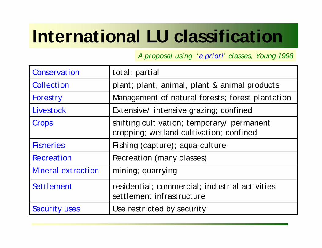
International LU classificationA proposal using ‘a priori’ classes, Young 1998

Use restricted by securitySecurity uses

residential; commercial; industrial activities; settlement infrastructure

Settlement

mining; quarryingMineral extraction

Recreation (many classes)Recreation

Fishing (capture); aqua-cultureFisheries

shifting cultivation; temporary/ permanent cropping; wetland cultivation; confined

Crops

Extensive/ intensive grazing; confinedLivestock

Management of natural forests; forest plantationForestry

plant; plant, animal, plant & animal productsCollection

total; partialConservation

Reasons for updating many national systems• Incomplete inventories of existing land uses• Insufficient consistency and precision in categorizing land uses• Greater user expectations of data content (must support an increasing

range of LU applications e.g. site selection, taxation, environmental impact assessment, ..)

• inadequate standards for data collection (at times related to lack of inter-agency cooperation) & data sharing

• outdated data inventory methodologies that do not exploit GIS, databases and other modern information technologies

National LU classification systems

Generally, ‘a priori’ systems (Classes defined before data collection)

Classification vs. characterization IParametric characterization of land use1. Describe land use activity (activities) by their attributes,

• Attributes (Inputs, management, outputs)2. Group attributes into classes according to end-user criteria

• GIS analysis

Where?Location& spatial extent

What?Objectives:Products, services

How?Management: inputs, technologies

Why?eg. reasons (biophysical, socio-economic,.)

When?Timing of operations

How much?Quantities: areas, products, ..

Complexity of agricultural land use

•Socio-economic purpose (s) driving modifications of existing environment •Uses: simultaneous/ different periods of 1 yr/ different uses in different years

Attributes: agricultural land use

Harvest technology, silviculture, disturbances, timber exploitation,..

Forestry

Level of intensification, access to feed & water resources; access to services (e.g. veterinary, extension,..)

Livestock

cropping systems; pest/weed management; nutrients, erosion, water, power sources

Crops

Management attributes

Spiritual, recreational, aesthetic, inspirational; educational, communal, symbolic,..

Cultural services

Climate regulation, disease control, flood control, detoxification, ..

Regulating services

Food; freshwater; fibre; bio-chemicals, genetic resources

Material products

Benefits

Development of LU data entry tools

Inventory methodologies

• Interpretation air photographs/ remote sensing imagery• Timing of imagery acquisition (single/ multiple dates)• Scale / spatial resolution of imagery• Approaches

– Grid sampling (& interpretation keys)– mapping approaches (e.g. Africover) using LCCS

Land cover inventory

1. Inference from land cover maps• problematic, but ready availability of LC data• participatory LU mapping

2. Direct observation, interviews, questionnaires• full enumeration, accurate but costly• statistical-based sampling (e.g. area frame -

National census); statistics not maps3. Inference from statistical & other data (e.g.

population); incompatibilities 4. Designated use areas

• actual use may be different (e.g. illegal incursions of protected areas)

Land use inventory

Evaluation criteria: Inventories• Cost• Complexity/ rapidity of data collection/update

procedures • Accuracy and consistency of output data (in space and

in time)• Compatibility of output with that from other systems

of data collection• Flexibility (e.g. classification adapts to changes in

scale; supports a broad range of analyses)

LU inventory: Switzerland

• 41,285 sq. km.• Air-photo interpretation.

(1:28,000 to 1:32,000) • Regular grid: 100m by

100m• 74 predefined hierarchical

LU classes• 1 type of LU per point;

(4.1million points)• Some field verification

http://www.statistik.admin.ch/stat_ch/ber02/asch/methode/finterpr.htm

LU inventory: France

• (TER-UTI)• observation sites (3m X 3m)• 81 physical and 25 functional

pre-established LU categories

France

4700 grid cells

8 segments per grid4 segments for observation

36 observation points

FUNCTIONAL NOMENCLATURELevel I

Primary productionSecondary production Services and miscellaneous

PHYSICAL NOMENCLATURELevel I

Permanent waters and wetlandsRock, pebbles, sand Wooded areaUtilized agricultural areaArtificial areas

LU inventory: EU

• 15 EU countries; • Harmonized data• Spring: LC/LU &

environment• Autumn: farmer interview

for info on yields, agricultural practices

• PSU: 18km X 18km• SSU: 10 points (300m X

300m) at centre of PSU• Circle 3m diameter• 20m for heterogeneous

zones

From Bettio et al, 2002

Land use/ cover area frame statistical survey - LUCAS

LU inventory: EU

From Bettio et al, 2002

Land use/ cover area frame statistical survey - LUCAS

SSU: 10 points (300m X 300m)

Land Use ClassesAgricultureForestryFishingMining, QuarryingEnergy productionIndustry, manufacturingTransport, communication, storage, protective woksWater, waste treatmentConstructionCommerce, finance, businessCommunity servicesRecreation, leisure, sportResidentialUnused

FRA/ ILUA inventory

Nested plots 1

Nested plots 3

20 m

500 m

4

3

1

500 m

N

Plot 250x20 m2

Plot start

Plot end

r = 3,99m×10 m

(+ 10m)(− 10m)20 m

125

m

250

m

10 m

Plot central line

Nested plots 2

Plot starting point

• LU & LC data are useful for decision making in a wide range of environmental & policy issues

• Different approaches for classification/ characterization & inventory of LU & LC in different countries, depending on needs

• Different sources of LU & LC data –– Importance of Inter-agency coordination/ cooperation

in harmonization, data collection & reporting– Importance of relating national definitions of LU/LC

classes to the UNSD questionnaire on land use statistics

Summary – main points

Major national development sectors in DCs• Natural resources & the environment (agriculture, agro-

industries, forestry, minerals, water, fisheries,..)• Human resources (e.g. education, health services &

infrastructure)• Prevention & mitigation of natural disasters & military

conflicts• Crime prevention

Policy formulation & planning

The greater the scope of LU information collected (i.e. products, services & management) – the wider the range of decision making supported

Trade offs!!

FAO - LC classification system

NON-VEGETATED

Terrestrial

B1

Aquatic or regularlyflooded

landB2

built up & assoc.areas

B15

bare areas

B18

arti-ficialwater-bodies

B27

inlandwater

B28

VEGETATED

Terrestrial

A1

Aquatic or regularlyflooded

landA2

culti-vated

A11

natural/semi-natural

A12

cultiv-ated

A23

natural/semi-natural

A24

+ more classifiers & optional Attributes

•increasing worldwide adoption of LCCS as standard•possible to relate LCCS & UNSD classes (NB. forest thresholds differ – 15 vs. 10%)

FAO Land cover classification system II

VEGETATED

Terrestrial - A1 Aquatic/reg. flooded land - A2

cultivated A11 (semi)natural A12 cultivated A23 (semi)natural A24

A. Life form B. Spatial Aspects

C. Crop combination

D. Cover relatedcultural practices

L.Land form

M/NLith./Soils

OClimate

P. Altitude Q. Erosion W. Cover

S. Crop type

Environmental attributes

Technical (discipline) attributes

Classifiers

CODE: A11 A1 B2 C1 D1

LCCS: Classifiers & attributes –A11A. Life form

B. Spatial Aspects

C. Crop combination

D. Cultural practices

L. Land form

M/N. Lithology /Soils

O. Climate

P. Altitude

Q. Erosion

W. Crop Cover/ density

S. Crop type

•trees, shrubs, herbaceous,.

•large, medium, small sized fields•continuous, scattered (clustered, isolated)•single, multiple crop•rainfed, post flooding, irrigated,.•shifting cultivation, fallow, permanent

•food/ non-food crops

•level, sloping, steep land; composite landforms•igneous, sedimentary, metamorphic•bare rock, soil, loose sands, hard pans; soil group•tropics, sub-tropics, temperate, ... .; LGP

•<300, 300-1500, 1500-3000, 3000->5000 metres,.

•erosion visible, not visible.

•permanent (trees, shrubs); temporary (herbaceous)

treessmall-sized single crop

rainfed


Recommended