+ All Categories
Home > Documents > Sheet 1 of 2 - USGS · Kccl Kcg Qoa Kccl Kccl Kccl Jgdg Kcg Qya Kcg Kcg Kccl Tbg Kcgp Kcg Kcg Kcpg...

Sheet 1 of 2 - USGS · Kccl Kcg Qoa Kccl Kccl Kccl Jgdg Kcg Qya Kcg Kcg Kccl Tbg Kcgp Kcg Kcg Kcpg...

Date post: 21-Jul-2018
Category:
Upload: leliem
View: 230 times
Download: 0 times
Share this document with a friend
1
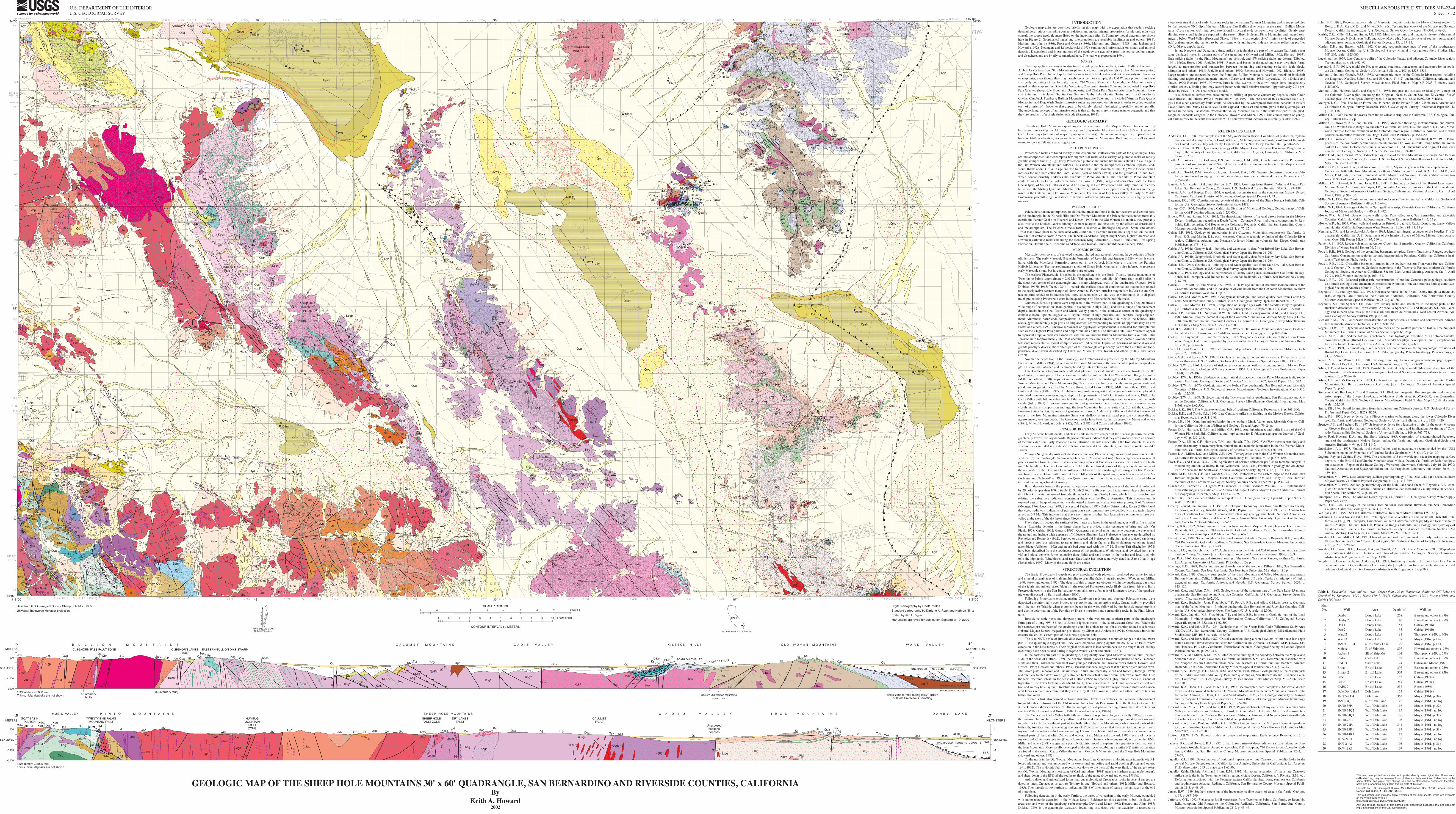
Tdvc Td Tc Qya Qya Qoa Qoa Tblc Tbl Qblc Tdv Jbv? Qo Qbl Tab Qoa Qoa Qoa Tdi Jbv? Jbv? Jbv? Tdi Td Tdv Tc Qya Qy Qbl Qoa Qoa Qps Qps Qba Qpsh Qya Qpb Qpb Qoa Qpsg Jd Qoa Td Ycm m Qpsh Qya Jd Ycm KJpg Jd Ycm Tbst Ycm Qy Qya Qya Jsm Qoa Qya Xf Dm PMb Kl ts Ko YXg Qya t t Dm ts Dm Xf Kl Xk Km Qoa Xk Xk Xk Ks Ks Ks YXg Ko Ko ts Ks Qoa Qya Xk Xk a a a a Ko Qoa Ko Ks Qy Ko Kop Qya Qya Ko Ko Km ts Kop Km Xs Km Ko Qoa Xk Qoa Xk Ko ts Ko Ko Ko a Ko Xk Xk Km Km Qoa ts t Dm PMb Ko ts Jd Jg Jk t rb Ks Jqk Qwy Xf Pk Pk Dm Jc Jk Jc Jqk ts Qoa Ko PMb PMb Xf Ks rb Kcg Qwy Kck Xgn Qya Qwy Qwo Qwo Qwo Kcg Kccp? s m Kcg Qpsg Qps Qwy Kcg Jbv? Qwy Jgg Jbv? Kcg Qoa Qoa Qoa Jbv? Kcsh Jbv? Qoa Qoa Jbep Jbv? Jbv? Xbg Tdi Tbv Kcg Qoa Ja Qya Jbv Jbv Qoa Jbv Jbpm Jbv Jbpm Jbv Jbe Jbv Jbv Jcp Qoa Jcp Jcp Jbv Jcp Jbq Qoa Qbr Qo Jbv Qoa Qoa Kcsh Kcsh Kcg Qya Jbpm Jbep Tdi Qya s m Tdi Jbv Jvh Jbq Qps Jbq Kcsh Jbv Qbr Jbs Tg q Qo Jvh Qya Jbv Jbq Qss Jcp? Qya Jbv Jl Jbs Qy Jbq Qoa Jvh Qo Jvh Qoa Qo Jbv Jbv Tvm Qoa Jbv Ja Jbv Qoa Qya Qwy Qoa Qoa Qoa Qo Qo Qoa Qya Qo Xp Xdw Xsg Xp Kwt Tg Qbr Qch Qo Qch Jbv Qss Qss Qss Qya Qoa Qoa Jbv Xag Xbg Qwy Qya Qya Qya Qya Qya pm? Qwy Qwy Qpsh Qya Qy Qya Qwy Jcp? Qy Qya Jcp? Qoa Jbv Qoa Qya Qya Qy Qo Qoa Qoa Kcsm Kcsm Kcgp s m t Xgn Qwy Tcs Tdv Tdv Tbv Tdv Qwy Qwy Kcg t Dm m Xgn Xgn Xgn Jgrg Jgrg Jgrg Xg Kccm Qya Qwy Xg Kccm Kcg ts Kcsm? Kcg Kcg Kcg YXd Qya Kcg Qwy Qpsh Qpsg Qya Qya Qoa Qoa Qoa Qwy Kcgi Qoa Kck Kck Xgn Kcsk Kcsk Qya Qya Xk Kop Qoa Km ts Xk ts ts Ko ts Ko Kop Xk Km Xk Qps Qya Qya Qwy Qwy Qy Qwy Qps Qpsh Qpsg Qy Qy Qwo Qya Qps Qoa Kia Kia Kid Qoa Kid Qy Qwy Qya Qoa Kid Kid Qoa Qoa ts ts Kii Kig ts Qoa Qoa Qoa Qwy Qwo Tbg Tdi Qoa Kii ts Qya Qy Kid Kii Qya Kig Qoa Qoa Kig Kigm ts ts Qwy Qya Qoa Kid ts Kig Qoa Tb Tb Kid Qwo Qwy Kccl Kcg Qoa Kccl Kccl Kccl Jgdg Kcg Qya Kcg Kcg Kccl Tbg Kcgp Kcg Kcg Kcpg Kcg Kcg Kcgp Kcg Kcgp Qoa Qy Qwy Kccp KJpg Kcg Qya Kcg Jbv Kcgi Jggd Jpqm Jd Kccp Jd Kcgp Jg Jg Jh s q Qwy Qya Kcsh Qya s Jggd s Jbv Jggd Jgg Jbv Qoa Kcg Qss Kcg Qy Xbg Xbg Qoa Xd Jd Qoa Jd Xdw Xd Xp Xdw Xdw t Qya Xdw Xbg Xp Jgb Jd Xp t Xag Qoa Jd Xdw Qoa Xp Jgb Jgb Xsg Jg Qy Jd Jd Xd t Jg lgt Jbv Qy Xp Jm Jbv Qya Kf Kf Jd p Xjt Qo Qoa Jbv Jbv Qoa Qo Qo p pm Xjt Jcp? Jbv Jcp? Jbv Qwy Qya Qy Qoa Qoa Qwy Qoa Jbv Qya Jbv Qoa Jbv Qoa Jbq Jbq Jbv Jcp? Jl Jvh Jcp? Qya Jcp? Jcp? Jvh Jdl Jdl Jvh Jcp? Jdl Jbv Jdl Jbq Qoa Jbq Jbv Qya Qo Qwy Jdl Jvh Jdl Jh Qy Qya Jvh Qoa Qoa Jh Qwy Qwy Jbv Jbv Qoa Qoa Jdl Qya Jbqm Jbqm Jbqm Jbv Qo Jbq Jbq Jbq Jbq Qoa Qoa Jcp? Jcp? Jvh Qya Jdl Jdl Qya Kcc Kcgp Kcgp Kcgp Kcgp Qy Qya Kcg Kcc Qoa KJm Qoa Qy Qwy Qoa Kigd Kid Tbg Kig Qoa Kig Kig Qya Jgdg Jgdg Jgdg Jgdg Kigd a Xs Qoa Qoa Qya Qy Qwy Qoa Qy Qya Qya Qoa Qoa Qoa Jgdg Jgdg Xs a Kid? Kid? Qo ts Xgn Qy Qo Qwy Qya Qya Qy Qya Qo Jdl Qy Qwy Jbv Jcp Qya Jmd Jdu Jgp Tdd Tdd Tdd Jbpm Jgp Jmd Qo Qbr Kcgp Qo Jbv Jbe Jbep Jbpm Kcsh Qo Qoa Qya Qo Tdv Tdv Tdv Tdi Kcsh Kcsh Kcg? Kcg? Kcg? Kcg? Kcg? Kck? Kck? Kcg Kcg Kcg Xgn Qo Kcg Tcs Tcs m t t t Dm Dm PMb ts ts Qo Xk Km Km Km Km Km ts Xk? Xk? Kcg m s m Tdd Tdd Tdd Tdd Xf b b PMb PMb Qo Xf Pk Ks Ko Ko Ko Kck Kck Xk? Kck? Qpsh ts ts ts ts Kop Qo Kop? Kop? Xgn? Xk Ko Xdw Jgb Jd Xag Xsg Xdw Xjt Xdw Xbg lgt Xp Xp Xbg Xdw Xdw Jd Jmd Jmd Xbg Xd Xd Jmd Jmd Jbv Xjt Jmd Jmd Jmd Jgp Jgp Jgp Jl Qo Jdu Jgp Jmd Jmd Qoa Qo Jd t Jbv Qoa Jvh Jbv Jcp? Kccp Kcg Kcg Kcgp Qo Qoa Qoa Tbg Kcg Kccl Qo Kii Kig Kig ts ts Tbd Tbd Qpsg Kii? Tbg Qoa ts ts Qo ts Kii Kid Kid Kid Qoa Qoa Qoa Qpsh Qps ts Kid Qoa Qya Jd Kcf Jbqm Ja Jgdg Jgdg Jgdg Kigm Jgdg Jbqm KJpg Qo Qoa Qo Xd Xp Jcp? Jbv 12 13 14 15 16 307m 153m 247m 307m 537m 8 9 897m 101m 268m 140m 154m 181m 137m 1 2 3 5 6 153m 4 7 170m 10 11 152m 124m 18 19 17 363m 122m 133m 20 21 22 24 25 26 27 28 29 116m 115m 126m 105m 344m 117m 112m 130m 103m 107m 23 30 20 20 60 35 35 20 80 45 25 10 45 85 75 80 50 89 30 30 70 45 45 40 25 20 20 20 20 10 40 25 40 20 30 45 15 0 60 25 30 50 45 80 35 65 55 30 10 5 20 45 30 40 15 5 25 40 45 50 30 50 50 50 50 85 80 80 60 60 50 60 80 45 70 40 55 30 50 25 80 50 65 70 35 35 40 10 75 70 30 35 35 50 75 35 55 50 20 50 75 55 65 80 70 40 30 50 35 30 60 15 65 60 35 5 25 70 5 5 60 60 45 45 40 45 70 60 45 80 40 80 75 75 80 40 10 45 15 5 30 40 60 80 40 65 50 45 55 15 40 40 60 55 75 55 80 50 85 80 40 80 75 50 70 80 70 85 70 80 70 20 80 80 55 40 35 70 55 80 40 40 25 65 75 75 80 5 40 50 60 55 50 65 65 45 30 20 27 30 55 40 6 74 15 35 45 30 80 35 50 45 60 40 70 35 75 44 20 25 12 70 35 40 75 40 3 70 0 75 65 80 70 60 30 45 30 60 50 30 30 60 25 35 75 65 52 80 50 85 85 73 30 70 55 40 75 50 75 30 65 20 60 50 85 65 65 80 50 80 70 7 30 85 80 20 65 70 60 45 30 45 55 50 65 70 35 60 45 45 45 65 60 10 20 55 55 55 27 70 80 50 8 4 45 40 60 50 60 80 70 40 5 10 0 50 0 85 50 80 60 35 20 70 45 80 65 85 75 15 25 30 40 10 70 35 10 25 70 80 50 85 55 35 80 35 50 40 35 15 10 50 35 50 55 60 50 40 25 25 30 60 85 70 50 40 35 70 85 45 35 50 50 25 50 50 45 40 50 50 30 20 45 60 30 55 25 60 0 55 55 50 50 45 55 35 25 40 35 35 10 50 5 35 45 20 40 30 30 30 35 30 70 45 40 40 65 25 40 20 30 20 30 30 35 18 5 40 20 8 25 15 25 30 35 25 15 8 25 30 24 13 17 8 15 18 15 8 7 5 12 6 17 7 4 2 3 15 8 19 10 15 17 16 9 9 14 10 2 8 8 2 16 0 0 30 22 65 80 80 75 25 25 70 30 75 10 65 60 45 13 70 25 85 75 70 80 85 80 60 30 14 12 50 65 70 55 45 45 65 20 10 15 55 60 55 50 30 80 30 25 20 50 20 35 45 80 80 70 75 65 80 60 40 60 45 35 0 75 65 80 56 50 85 40 75 0 50 30 60 35 35 36 60 74 55 45 40 35 60 40 85 65 60 4 5 0 40 75 30 42 25 16 18 42 45 45 50 70 65 20 55 1 8 12 5 10 40 55 50 80 80 75 70 5 55 80 55 60 70 50 55 45 30 35 30 25 50 30 30 35 5 55 5 5 50 15 20 40 45 55 15 33 31 15 35 20 35 25 35 60 73 35 85 48 45 35 30 50 45 25 70 45 70 35 30 85 23 80 20 10 38 48 5 35 50 35 25 65 55 55 2 45 50 40 70 40 27 50 58 22 60 40 55 4 75 75 70 70 80 60 30 10 47 80 60 35 50 45 45 30 35 15 0 45 25 1 45 60 80 50 40 80 70 70 0 65 70 40 5 73 30 18 34 60 30 45 50 45 70 60 80 89 60 85 20 20 73 70 55 40 45 50 40 40 60 45 40 20 23 80 50 30 70 20 69 7 50 80 44 55 60 65 88 74 85 65 20 25 50 15 55 85 80 70 75 30 70 80 24 35 45 25 45 20 75 80 65 70 65 70 50 70 80 65 20 45 15 50 0 27 35 45 40 35 3 5 23 41 66 15 28 15 66 0 0 9 16 7 15 44 15 7 0 12 12 6 8 2 8 11 0 26 15 13 21 8 6 5 20 0 0 28 28 28 72 24 38 16 9 19 72 4 22 29 15 14 18 2 4 42 32 42 31 33 66 30 42 10 28 26 31 22 10 6 12 21 7 0 35 70 65 60 26 17 15 25 22 35 35 80 45 15 60 16 12 20 12 25 20 18 12 5 10 35 45 5 8 5 30 15 4 10 4 60 60 35 25 27 35 20 28 0 50 70 30 75 72 62 20 35 25 35 50 25 85 80 45 50 20 25 25 0 0 0 70 60 45 80 70 72 55 55 60 80 20 65 65 30 30 75 32 35 85 5 30 70 11 49 45 80 80 60 80 75 35 85 65 75 40 52 35 80 44 40 12 35 30 30 45 38 28 10 2 60 ? ? ? ? ? Goat Basin Pluton Music Valley Pluton Dog Was h Fa ul t Humbu g M ount a i n Fa ul t East V alley M o untain F ault W es t V alley M o u ntain F ault Pin t o M o u n t a in F ault Mesquite Lake Fault T w e n t y n in e Pal ms M ounta i n F a u lt Sheep Hole Mountains Pluton L ud l ow Fa u l t we s t br a nch L u d l o w F a u l t e a s t b r a nc h Amboy Crater lava flow Ship Mountains Pluton t hr us t Sc a nl o n Scanl on t hr ust Painted Rock Pluton Old Woman Pluton B r e a kawa y F a u l t f o r C ol o r a d o R ive r ext e n s i on a l c o r r i d o r K i l be ck Fa ul t Ea s t er n B ul l i o n di ke s w a r m Cl eghor n Pa s s F a u l t Cleghorn Pass Pluton De l t a F a u l t C l eg h or n La k e s F a u l t Sheep Hole Pass Pluton I r o n M o u n t a i n s F a u l t C a l u me t F a u l t W e s t Ca l umet F a ul t She ep Hol e Fa ul t Granite Pass Pluton O l d D al e F a ul t I v a n h o e Fa u l t Dr y L a ke s F a u l t Table 1. Drill holes (wells and test wells) deeper than 100 m. [Numerous shallower drill holes are described by Thompson (1929), Moyle (1961, 1967), Calzia and Moore (1980), Rosen (1989), and Calzia (1991a,b,c)] Map No. Well Area Depth (m) Well log 1 Danby 1 Danby Lake 268 Bassett and others (1959) 2 Danby 2 Danby Lake 140 Bassett and others (1959) 3 Dan 1 Danby Lake 154 Calzia (1991b) 4 Dan 2 Danby Lake 153 Calzia (1991b) 5 Ward 2 Danby Lake 181 Thompson (1929, p. 709) 6 Ward 3 Danby Lake 137 Moyle (1967, p. D-2) 7 1S/18E-13L1 S. of Danby Lake 170 Moyle (1967, p. D-1) 8 Mojave 1 E. of Ship Mts. 897 Howard and others (1989a) 9 Archer 1 SE of Ship Mts. 101 Thompson (1929, p. 698) 10 Cadiz 1 Cadiz Lake 152 Bassett and others (1959) 11 CAD-1 Cadiz Lake 124 Calzia and Moore (1980) 12 Bristol 1 Bristol Lake 307 Bassett and others (1959) 13 Bristol 2 Bristol Lake 307 Bassett and others (1959) 14 BR-1 Bristol Lake 153 Calzia (1991a) 15 BR-2 Bristol Lake 247 Calzia (1991a) 16 CAES 2 Bristol Lake 537 Rosen (1989) 17 Dale Dry Lake 1 Dale Lake 133 Calzia (1991c) 18 1N/12-20D4 Dale Lake 363 Moyle (1961, p. 34) 19 1S/12-3Q1 S. of Dale Lake 122 Moyle (1961), no log 20 1N/10-36P1 W. of Dale Lake 116 Moyle (1961, p. 32) 21 1N/10-34Q2 W. of Dale Lake 115 Moyle (1961), no log 22 1N/10-34Q1 W. of Dale Lake 126 Moyle (1961, p. 32) 23 1N/10-22J1 W. of Dale Lake 105 Moyle (1961), no log 24 1N/10-21F1 W. of Dale Lake 344 Moyle (1961), no log 25 1N/10-15R1 W. of Dale Lake 117 Moyle (1961, p. 31) 26 1N/10-14K1 W. of Dale Lake 112 Moyle (1961), no log 27 1N/9-24L1 W. of Dale Lake 130 Moyle (1961), no log 28 1N/9-24A1 W. of Dale Lake 103 Moyle (1961, p. 31) 29 1N/9-13K1 W. of Dale Lake 107 Moyle (1961), no log MISCELLANEOUS FIELD STUDIES MF–2344 Sheet 1 of 2 INTRODUCTION Geologic map units are described briefly on this map, with the expectation that readers seeking detailed descriptions (including contact relations and modal mineral proportions for plutonic units) can consult the source geologic maps listed on the index map (fig. 1). Summary modal diagrams are shown here in Figure 2. Geophysical maps and interpretations are available in Simpson and others (1984), Mariano and others (1986), Frost and Okaya (1986), Mariano and Grauch (1988), and Jachens and Howard (1992). Neumann and Leszcykowski (1993) summarized information on mines and mineral deposits. Discussions and interpretations of the geology are available from the source geologic maps and elsewhere, and are briefly summarized here. The map was prepared in 1994. NAMES The map applies new names to structures including the Ivanhoe fault, eastern Bullion dike swarm, Amboy Crater lava flow, Ship Mountains pluton, Cleghorn Pass pluton, Sheep Hole Mountains pluton, and Sheep Hole Pass pluton. I apply pluton names to structural bodies and not necessarily to lithodemes or map units, even though they may largely coincide. For example, the Old Woman pluton is an intru- sive body consisting of the formally named Old Woman Mountains Granodiorite. Map units newly named on this map are the Dale Lake Volcanics; Coxcomb Intrusive Suite and its included Sheep Hole Pass Granite, Sheep Hole Mountains Granodiorite, and Clarks Pass Granodiorite; Iron Mountains Intru- sive Suite and its included Granite Pass Granite, Danby Lake Granite Gneiss, and Iron Granodiorite Gneiss; Chubbuck Porphyry; Bullion Mountains Intrusive Suite and its included Virginia Dale Quartz Monzonite; and Dog Wash Gneiss. Intrusive suites are proposed on this map in order to group together each of a series of lithodemes that appear to be closely related lithologically, spatially, and temporally. The underlying concept of an intrusive suite is that all the units are in some manner cogenetic and that they are products of a single fusion episode (Bateman, 1992). GEOLOGIC SUMMARY The Sheep Hole Mountains quadrangle covers an area of the Mojave Desert characterized by basins and ranges (fig. 3). Alluviated valleys and playas (dry lakes) are as low as 165 m elevation at Cadiz Lake playa (see map of major topographic features). The mountain ranges they separate are as high as 1490 m elevation, for example in the Old Woman Mountains. Rock units are well exposed owing to low rainfall and sparse vegetation. PROTEROZOIC ROCKS Proterozoic rocks are found mostly in the eastern and southwestern parts of the quadrangle. They are metamorphosed, and encompass few supracrustal rocks and a variety of plutonic rocks of mostly granitic composition (fig. 2g). Early Proterozoic plutonic and metaplutonic units about 1.7 Ga in age in the Old Woman Mountains and Kilbeck Hills underlie the metamorphosed Cambrian Tapeats Sand- stone. Rocks about 1.7 Ga in age are also found in the Pinto Mountains: the Dog Wash Gneiss, which intrudes the unit here called the Pinto Gneiss (part) of Miller (1938), and the granite of Joshua Tree, which nonconformably underlies the quartzite of Pinto Mountain. The quartzite of Pinto Mountain could be as old as Early Proterozoic based on Powell's (1982) suggested correlation with the Pinto Gneiss (part) of Miller (1938), or it could be as young as Late Proterozoic and Early Cambrian if corre- lative with the Stirling Quartzite. Middle Proterozoic plutonic rocks (approximately 1.4 Ga) are recog- nized in the Calumet and Old Woman Mountains. The gneiss of Dry lakes valley, of Early or Middle Proterozoic protolithic age, is distinct from other Proterozoic intrusive rocks because it is highly peralu- minous. PALEOZOIC ROCKS Paleozoic strata metamorphosed to sillimanite grade are found in the northeastern and central parts of the quadrangle. In the Kilbeck Hills and Old Woman Mountains the Paleozoic rocks nonconformably overlie the Fenner Gneiss of Hazzard and Dosch (1937); in the Old Woman Mountains, they probably also overlie the Kilbeck Gneiss although contact relations are obscured by the effects of deformation and metamorphism. The Paleozoic rocks form a distinctive lithologic sequence (Stone and others, 1983) that allows them to be correlated with Cambrian to Permian marine units deposited on the shal- low shelf of cratonic North America: the Tapeats Sandstone, Bright Angel Shale, higher Cambrian and Devonian carbonate rocks (including the Bonanza King Formation), Redwall Limestone, Bird Spring Formation, Hermit Shale, Coconino Sandstone, and Kaibab Limestone (Stone and others, 1983). MESOZOIC ROCKS Mesozoic rocks consist of scattered metamorphosed supracrustal rocks and large volumes of bath- olithic rocks. The early Mesozoic Buckskin Formation of Reynolds and Spencer (1989), which is corre- lative with the Moenkopi Formation, crops out in the Kilbeck Hills where it overlies the Permian Kaibab Limestone. The metasedimentary gneiss of Sheep Hole Mountains is also inferred to represent early Mesozoic strata, but its contact relations are obscure. The earliest Phanerozoic intrusion in the quadrangle is the Early Triassic quartz monzonite of Twentynine Palms (approximately 240 Ma). This quartz-poor unit (fig. 2f) forms four small bodies in the southwest corner of the quadrangle and is more widepread west of the quadrangle (Rogers, 1961; Dibblee, 1967b, 1968; Trent, 1984). It records the earliest phase of continental arc magmatism related to the newly active western margin of North America. Further intrusive magmatism in Jurassic and Cre- taceous time tended to be increasingly more siliceous (fig. 2), and was so voluminous as to displace much pre-existing Proterozoic crust in the quadrangle by Mesozoic batholithic rocks. Numerous Jurassic plutons were emplaced in the western part of the quadrangle. They embrace a wide range of compositions from gabbro to syenogranite (figs. 2d,e), and also a range of emplacement depths. Rocks in the Goat Basin and Music Valley plutons in the southwest corner of the quadrangle contain euhedral epidote suggestive of crystallization at high pressure, and therefore, deep emplace- ment. Aluminous hornblende compositions in an unspecified Jurassic dike rock in the Kilbeck Hills also suggest moderately high-pressure emplacement (corresponding to depths of approximately 16 km; Foster and others, 1992). Shallow mesozonal or hypabyssal emplacement is indicated for other plutons such as the Cleghorn Pass pluton and Ship Mountains pluton. The Jurassic Dale Lake Volcanics appear to represent eruptive products associated with the voluminous Bullion Mountains Intrusive Suite. This Jurassic suite (approximately 160 Ma) encompasses rock units most of which contain lavender alkali feldspar; representative modal compositions are indicated in Figure 2d. Swarms of mafic dikes and granite prophyry dikes in the western part of the quadrangle are probably part of the Late Jurassic Inde- pendence dike swarm described by Chen and Moore (1979), Karish and others (1987), and James (1989). Nonmarine deposition in the Jurassic(?) and Cretaceous is represented by the McCoy Mountains Formation of Miller (1944), present in the Coxcomb Mountains in the south-central part of the quadran- gle. This unit was intruded and metamorphosed by Late Cretaceous plutons. Late Cretaceous (approximately 70 Ma) plutonic rocks dominate the eastern two-thirds of the quadrangle, forming parts of two coeval and similar batholiths. The Old Woman-Piute Range batholith (Miller and others, 1990) crops out in the northeast part of the quadrangle and farther north in the Old Woman Mountains and Piute Mountains (fig. 2c). It consists chiefly of metaluminous granodiorite and peraluminous granite described by Miller, Howard, and Hoisch (1982), Miller and others (1990), and Foster and others (1989, 1992). Hornblende compositions suggest that the granodiorite was emplaced at estimated pressures corresponding to depths of approximately 15–19 km (Foster and others, 1992). The Cadiz Valley batholith underlies much of the central part of the quadrangle and areas south of the quad- rangle (John, 1981). It encompasses granite and granodiorite here divided into two intrusive suites closely similar in composition and age, the Iron Mountains Intrusive Suite (fig. 2b) and the Coxcomb Intrusive Suite (fig. 2a). By means of geobarometric study, Anderson (1988) concluded that intrusion of rocks in the Iron Mountains Intrusive Suite was shallow, at an estimated pressure corresponding to approximately 6–8 km depth. The Cretaceous rocks have been further discussed by Miller and others (1981), Miller, Howard, and John (1982), Calzia (1982), and Calzia and others (1986). CENOZOIC ROCKS AND DEPOSITS Early Miocene basalt, dacite, and clastic units in the western part of the quadrangle form the strati- graphically lowest Tertiary deposits. Regional relations indicate that they are associated with an episode of tectonic extension. Early Miocene dacitic intrusions include a laccolith in the Iron Mountains, a sub- volcanic stock intruded into a dacitic volcanic carapace at Lead Mountain, and the eastern Bullion dike swarm. Younger Neogene deposits include Miocene and (or) Pliocene conglomerate and gravel units in the west part of the quadrangle. Sedimentary breccia of Miocene and (or) Pliocene age occurs in several patches isolated from its source materials and may represent landslides associated with strike-slip fault- ing. The basalt of Deadman Lake volcanic field in the northwest corner of the quadrangle and rocks of the remainder of the Deadman Lake volcanic field west of the quadrangle are assigned a late Pliocene age based on correlation with basalt at Dish Hill north of the quadrangle, which was dated as 2 Ma (Wilshire and Nielson-Pike, 1986). Two Quaternary basalt flows lie nearby, the basalt of Lead Moun- tain and the younger basalt of Amboy. Basin deposits beneath the present valleys have been explored by scores of shallow drill holes and by 29 holes deeper than 100 m (table 1). Smith (1960, 1970) described faunal assemblages characteris- tic of brackish water, recovered from depth under Cadiz and Danby Lakes, which form a basis for cor- relating the subsurface sediments containing them with the Bouse Formation. This Pliocene unit is exposed east of the quadrangle and was deposited in lakes and (or) an estuarine proto-gulf of California (Metzger, 1968; Lucchitta, 1979; Spencer and Patchett, 1997). Below Bristol Lake, Rosen (1989) found that cored sediments indicative of persistent playa environments are interbedded with six tephra layers as old as 3.7 Ma. This indicates that playa environments rather than lacustrine environments have pre- vailed at the sites of the dry lakes since Pliocene time. Playa deposits occupy the surface of four large dry lakes in the quadrangle, as well as five smaller basins. Evaporite deposits in the larger playas have provided major resources of brine and salt (Ver Plank, 1958; Calzia, 1992; Gundry, 1992). Quaternary alluvial units intervene between the playas and the ranges and include wide expanses of Holocene alluvium. Late Pleistocene faunas were described by Reynolds and Reynolds (1992). Perched or dissected old Pleistocene alluvium and associated sandstone and breccia crop out adjacent to range fronts and along faults; a Rancholabrean vertebrate faunal assemblage (Jefferson, 1992) and an ash bed correlated with the 0.7-Ma Bishop Tuff (Bacheller, 1978) have been described from the southwest corner of the quadrangle. Windblown sand reworked from allu- vial and playa deposits forms extensive dune fields and sand sheets in the basins and locally climbs onto the highlands. Windblown sand near Dale Lake has been tentatively dated as 5 to 60 ka in age (Tchakerian, 1992). Many of the dune fields are active. STRUCTURAL EVOLUTION The Early Proterozoic Ivanpah orogeny associated with plutonism produced pervasive foliation and mineral assemblages of high amphibolite to granulite facies in nearby regions (Wooden and Miller, 1990; Foster and others, 1992). The details of this orogeny are obscure within the quadrangle, but much of the fabric and mineral assemblages in the exposed Proterozoic rocks likely date from this era. Early Proterozoic events in the San Bernardino Mountains area a few tens of kilometers west of the quadran- gle were discussed by Barth and others (2000). Following Proterozoic erosion, marine Cambrian sandstone and younger Paleozoic strata were deposited unconformably over Proterozoic plutonic and metamorphic rocks. Crustal stability prevailed until the earliest Triassic when plutonism began in the west, followed by pre-Jurassic metamorphism and ductile deformation of the Permian or Triassic intrusions and surrounding rocks in the Pinto Moun- tains. Jurassic volcanic rocks and elongate plutons in the western and southern parts of the quadrangle form part of a long NW–SE belt of Jurassic igneous rocks in the southwestern Cordillera. Where the belt narrows just southeast of the quadrangle could be a place to look for disruption related to a Jurassic sinistral Mojave-Sonora megashear postulated by Silver and Anderson (1974). Cretaceous intrusions obscure the critical eastern part of the Jurassic igneous belt. The N to NNW strike of Jurassic dike swarms that are present in mountain ranges in the southwest part of the quadrangle suggest that they were emplaced during approximately E–W or ENE–WSW extension in the Late Jurassic. Their original orientation is less certain because the ranges in which they occur may have been rotated during Neogene events (Carter and others, 1987). In the northeastern part of the quadrangle, a regionally developed Mesozoic ductile fault (tectonic slide in the sense of Hutton, 1979), the Scanlon thrust, places an inverted sequence of early Paleozoic strata and their Proterozoic basement over younger Paleozoic and Triassic rocks (Miller, Howard, and Hoisch, 1982; Howard and others, 1987). Present evidence suggests that the upper plate moved west. The lower plate Paleozoic and Triassic rocks in turn are internally sliced and folded (Horringa, 1989) and ductilely faulted down over highly strained tectonic schist derived from Proterozoic protoliths. I use the term "tectonic schist" in the sense of Hutton (1979) to describe highly foliated rocks in a zone of high strain. The lower tectonic slide (ductile fault), here termed the Kilbeck fault, attenuates crustal sec- tion and so may be a lag fault. Relative and absolute timing of the two major tectonic slides and associ- ated fabrics remain uncertain, but they are cut by the Old Woman pluton and other Late Cretaceous batholithic rocks. Tectonic schist also formed at lower structural levels as envelopes that separate subhorizontal tonguelike sheet intrusions of the Old Woman pluton from its Proterozoic host, the Kilbeck Gneiss. The Kilbeck Gneiss shows evidence of ultrametamorphism and partial melting during the Late Cretaceous events (Miller, Howard, and Hoisch, 1982; Howard and others, 1989b). The Cretaceous Cadiz Valley batholith was intruded as plutons elongated chiefly NW–SE, as were the Jurassic plutons. Intrusion recrystallized and foliated a western aureole approximately 2–3 km wide in older rocks. In the southeast part of the batholith in the Iron Mountains, early-intruded parts of the batholith, together with intervening screens of Proterozoic rocks that became tectonic schist, were mylonitized throughout a thickness exceeding 1.3 km in a subhorizontal roof zone above younger unde- formed parts of the batholith (Miller and others, 1981; Miller and Howard, 1985). Sense of shear in mylonitized Cretaceous granite (Danby Lake Granite Gneiss), where measured, is top to the ENE. Miller and others (1981) suggested a possible diapiric model to explain this synplutonic deformation in the Iron Mountains. More locally developed mylonitic rocks exhibiting a similar NE strike of lineation are found to the west in Cadiz Valley, the northern Coxcomb Mountains, and the Sheep Hole Mountains (Howard and others, 1982). To the north in the Old Woman Mountains, local Late Cretaceous mylonitization immediately fol- lowed plutonism and was associated with extensional unroofing and rapid cooling (Foster and others, 1991, 1992). The mylonitic fabrics record shear down to the west off the west flank of the range (West- ern Old Woman Mountains shear zone of Carl and others (1991) near the northern quadrangle border), and shear down to the ESE off the southeast flank of the range (Howard and others, 1989b). Aplitic dikes and mineralized joints that cut mylonitized Cretaceous rocks in several ranges are dated as latest Cretaceous or earliest Tertiary in age (Howard and others, 1982; Miller and Howard, 1985). They mostly strike northwest, indicating NE–SW orientation of least principal stress at the end of plutonism. Following denudation in the early Tertiary, the onset of volcanism in the early Miocene coincided with major tectonic extension in the Mojave Desert. Evidence for this extension is best displayed in areas east and west of the quadrangle (for example, Davis and Lister, 1988; Howard and John, 1987; Dokka, 1989). In the quadrangle, westward downtilting associated with the extension is recorded by steep west stratal dips of early Miocene rocks in the western Calumet Mountains and is suggested also by the moderate NNE dip of the early Miocene East Bullion dike swarm in the eastern Bullion Moun- tains. Cross section AA' interprets extensional structural style between these localities. Gently east- dipping extensional faults are exposed in the eastern Sheep Hole and Pinto Mountains and imaged seis- mically below Ward Valley (Frost and Okaya, 1986). In cross section AA', I infer a style of concealed half grabens under the valleys to be consistent with unmigrated industry seismic reflection profiles (D.A. Okaya, unpub. data). In late Neogene and Quaternary time, strike-slip faults that are part of the eastern California shear zone displaced rocks in western parts of the quadrangle (Howard and Miller, 1992; Richard, 1993). East-striking faults (in the Pinto Mountains) are sinistral, and NW-striking faults are dextral (Dibblee, 1961, 1967a; Hope, 1966; Jagiello, 1991). Ranges and basins in the quadrangle may owe their forms largely to transpression and transtension between the moving and rotating strike-slip fault blocks (Simpson and others, 1984; Jagiello and others, 1992; Jachens and Howard, 1992; Richard, 1993). Large rotations are expected between the Pinto and Bullion Mountains based on models of bookshelf faulting and regional paleomagnetic studies (Carter and others, 1987; Luyendyk, 1991; Dokka and Travis, 1990; Richard, 1993). However, Jurassic dike swarms in these two ranges have unexpectedly similar strikes, a finding that may accord better with small relative rotation (approximately 20°) pre- dicted by Powell's (1993) palinspastic model. A slickensided surface was encountered in drilling of probable Quaternary deposits under Cadiz Lake (Bassett and others, 1959; Howard and Miller, 1992). The presence of this concealed fault sug- gests that other Quaternary faults could be concealed by the widespread Holocene deposits in Bristol Lake, Cadiz, and Danby Lake valleys. Faults exposed in the east and central parts of the quadrangle last moved in the early Pleistocene, whereas the Valley Mountain faults in the southwest part of the quad- rangle cut deposits assigned to the Holocene (Howard and Miller, 1992). This concentration of young- est fault activity to the southwest accords with a southwestward increase in seismicity (Goter, 1992). REFERENCES CITED Anderson, J.L., 1988, Core complexes of the Mojave-Sonoran Desert: Conditions of plutonism, myloni- tization, and decompression, in Ernst, W.G., ed., Metamorphism and crustal evolution of the west- ern United States (Rubey volume 7): Englewood Cliffs, New Jersey, Prentice Hall, p. 502–525. Bacheller, John, III, 1978, Quaternary geology of the Mojave Desert-Eastern Transverse Ranges boun- dary in the vicinity of Twentynine Palms, California: Los Angeles, University of California, M.S. thesis, 157 pp. Barth, A.P., Wooden, J.L., Coleman, D.S., and Fanning, C.M., 2000, Geochronolgy of the Proterozoic basement of southwesternmost North America, and the origin and evolution of the Mojave crustal province: Tectonics, v. 19, p. 616–629. Barth, A.P., Tosdal, R.M., Wooden, J.L., and Howard, K.A., 1997, Triassic plutonism in southern Cali- fornia: Southward younging of arc initiation along a truncated continental margin: Tectonics, v. 16, p. 290–304. Bassett, A.M., Kupfer, D.H., and Barstow, F.C., 1959, Core logs from Bristol, Cadiz, and Danby Dry Lakes, San Bernardino County, California: U.S. Geological Survey Bulletin 1045–D, p. 97–138. Bassett, A.M., and Kupfer, D.H., 1964, A geologic reconnaissance in the southeastern Mojave Desert, California: California Division of Mines and Geology Special Report 83, 43 p. Bateman, P.C., 1992, Constitution and genesis of the central part of the Sierra Nevada batholith, Cali- fornia: U.S. Geological Survey Professional Paper 1483. Bishop, C.C., 1964, Needles sheet: California Division of Mines and Geology, Geologic map of Cali- fornia, Olaf P. Jenkins edition, scale 1:250,000. Brown, W.J., and Rosen, M.R., 1992, The depositional history of several desert basins in the Mojave Desert: Implications regarding a Death Valley—Colorado River hydrologic connection, in Rey- nolds, R.E., compiler, Old Routes to the Colorado: Redlands, California, San Bernardino County Museum Association Special Publication 92–1, p. 77–82. Calzia, J.P., 1982, Geology of granodiorite in the Coxcomb Mountains, southeastern California, in Frost, E.G. and Martin, D.L, eds., Mesozoic-Cenozoic tectonic evolution of the Colorado River region, California, Arizona, and Nevada (Anderson-Hamilton volume): San Diego, Cordilleran Publishers, p. 173–181. Calzia, J.P., 1991a, Geophysical, lithologic, and water quality data from Bristol Dry Lake, San Bernar- dino County, California: U.S. Geological Survey Open-file Report 91–263. Calzia, J.P., 1991b, Geophysical, lithologic, and water quality data from Danby Dry Lake, San Bernar- dino County, California: U.S. Geological Survey Open-file Report 91–264. Calzia, J.P., 1991c, Geophysical, lithologic, and water quality data from Dale Dry Lake, San Bernar- dino County, California: U.S. Geological Survey Open-file Report 91–268. Calzia, J.P., 1992, Geology and saline resources of Danby Lake playa, southeastern California, in Rey- nolds, R.E., compiler, Old Routes to the Colorado: Redlands, California, San Bernardino County, p. 87–91. Calzia, J.P., DeWitt, Ed, and Nakata, J.K., 1986, U-Th-Pb age and initial strontium isotopic ratios of the Coxcomb Granodiorite, and a K-Ar date of olivine basalt from the Coxcomb Mountains, southern California: Isochron/West, no. 47, p. 3–7. Calzia, J.P., and Moore, S.W., 1980 Geophysical, lithologic, and water quality data from Cadiz Dry Lake, San Bernardino County, California: U.S. Geological Survey Open-file Report 80–273. Calzia, J.P., and Morton, J.L., 1980, Compilation of isotopic ages within the Needles 1° by 2° quadran- gle, California and Arizona: U.S. Geological Survey Open-file Report 80–1303, scale 1:250,000. Calzia, J.P., Kilburn, J.E., Simpson, R.W., Jr., Allen, C.M., Leszcykowski, A.M., and Causey, J.D., 1983, Mineral resource potential map of the Coxcomb Mountains Wilderness Study Area (CDCA- 328), San Bernardino and Riverside Counties, California: U.S. Geological Survey Miscellaneous Field Studies Map MF–1603–A, scale 1:62,500. Carl, B.S., Miller, C.F., and Foster, D.A., 1991, Western Old Woman Mountains shear zone; Evidence for late ductile extension in the Cordilleran orogenic belt: Geology, v. 19, p. 893–896. Carter, J.N., Luyendyk, B.P., and Terres, R.R., 1987, Neogene clockwise rotation of the eastern Trans- verse Ranges, California, suggested by paleomagnetic data: Geological Society of America Bulle- tin, v. 98, p. 199–206. Chen, J.H., and Moore, J.G., 1979, Late Jurassic Independence dike swarm in eastern California; Geol- ogy, v. 7, p. 129–133. Davis, G.A., and Lister, G.S., 1988, Detachment faulting in continental extension: Perspectives from the southwestern U.S. Cordillera: Geological Society of America Special Paper 218, p. 133–159. Dibblee, T.W., Jr., 1961, Evidence of strike-slip movement on northwest-trending faults in Mojave Des- ert, California, in Geological Survey Research 1961: U.S. Geological Survey Professional Paper 424-B, p. 197–199. Dibblee, T.W., Jr., 1967a, Evidence of major lateral displacement on the Pinto Mountain fault, south- eastern California: Geological Society of America Abstracts for 1967, Special Paper 115, p. 322. Dibblee, T.W., Jr., 1967b, Geologic map of the Joshua Tree quadrangle, San Bernardino and Riverside Counties, California: U.S. Geological Survey Miscellaneous Geologic Investigations Map I–516, scale 1:62,500. Dibblee, T.W., Jr., 1968, Geologic map of the Twentynine Palms quadrangle, San Bernardino and Riv- erside Counties, California: U.S. Geological Survey Miscellaneous Geologic Investigations Map I–561, scale 1:62,500. Dokka, R.K., 1989, The Mojave extensional belt of southern California: Tectonics, v. 8, p. 363–390. Dokka, R.K., and Travis, C.J., 1990, Late Cenozoic strike-slip faulting in the Mojave Desert, Califor- nia: Tectonics, v. 9, p. 311–340. Evans, J.R., 1964, Xenotime mineralization in the southern Music Valley area, Riverside County, Cali- fornia: California Division of Mines and Geology Special Report 79, 24 p. Foster, D.A., Harrison, D.T.M., and Miller, C.F., 1989, Age, inheritance, and uplift history of the Old Woman-Piute batholith, California, and implications for K-feldspar age spectra: Journal of Geol- ogy, v. 97, p. 232–243. Foster, D.A., Miller, C.F., Harrison, T.M., and Hoisch, T.D., 1992, 40 Ar/ 39 Ar thermochronology and thermobarometry of metamorphism, plutonism, and tectonic denudation in the Old Woman Moun- tains area, California: Geological Society of America Bulletin, v. 104, p. 176–191. Foster, D.A., Miller, D.S., and Miller, C.F., 1991, Tertiary extension in the Old Woman Mountains area, California: Evidence from apatite fission track analysis: Tectonics, v. 10, p. 875–886. Frost, E.G., and Okaya, D.A., 1986, Application of seismic reflection profiles to tectonic analysis in mineral exploration, in Beatty, B. and Wilkinson, P.A.K., eds., Frontiers in geology and ore depos- its of Arizona and the Southwest: Arizona Geological Society Digest, v. 16, p. 137–152. Gerber, M.E., Miller, C.F., and Wooden, J.L., 1995, Plutonism at the eastern edge of the Cordilleran Jurassic magmatic belt, Mojave Desert, California, in Miller, D.M. and Busby, C., eds., Jurassic tectonics of the Cordillera: Geological Society America Special Paper 299, p. 351–374. Glazner, A.F., Farmer, G.L., Hughes, W.T., Wooden, J.L., and Pickthorn, William, 1991, Contamination of basaltic magma by mafic crust at Amboy and Pisgah Craters, Mojave Desert, California: Journal of Geophysical Research, v. 96, p. 13,673–13,692. Goter, S.K., 1992, Southern California earthquakes: U.S. Geological Survey Open-file Report 92–533, scale 1:375,000. Greeley, Ronald, and Iverson, J.D., 1978, A field guide to Amboy lava flow, San Bernardino County, California, in Greeley, Ronald, Womer, M.B., Papson, R.P., and Spudis, P.D., eds., Aeolian fea- tures of southern California: A comparative planetary geology guidebook: National Aeronautics and Space Administration, and Tempe, Arizona, Arizona State University Department of Geology and Center for Meteorite Studies, p. 23–52. Gundry, R.R., 1992, Saline mineral extraction from southern Mojave Desert playas of California, in Reynolds, R.E., compiler, Old routes to the Colorado: Redlands, Calif., San Bernardino County Museum Association Special Publication 92–2, p. 65–70. Hazlett, R.W., 1992, Some thoughts on the development of Amboy Crater, in Reynolds, R.E., compiler, Old Routes to the Colorado: Redlands, California, San Bernardino County Museum Association Special Publication 92–1, p. 71–73. Hazzard, J.C., and Dosch, E.K., 1937, Archean rocks in the Piute and Old Woman Mountains, San Ber- nardino County, California [abs.]: Geological Society of America Proceedings 1936, p. 309. Hope, R.A., 1966, Geology and structural setting of the eastern Transverse Ranges, southern California: Los Angeles, University of California, Ph.D. thesis, 158 p. Horringa, E.D., 1989, Rocks and structural evolution of the northern Kilbeck Hills, San Bernardino County, California: San Jose, California, San Jose State University, M.S. thesis, 180 p. Howard, K.A., 1993, Cenozoic stratigraphy of the Lead Mountain and Valley Mountain areas, eastern Bullion Mountains, Calif., in Sherrod, D.R. and Nielson, J.E., eds., Tertiary stratigraphy of highly extended terranes, California, Arizona, and Nevada: U.S. Geological Survey Bulletin 2053, p. 123–126. Howard, K.A., and Allen, C.M., 1988, Geologic map of the southern part of the Dale Lake 15-minute quadrangle, San Bernardino and Riverside Counties, California: U.S. Geological Survey Open-file report, 17 p., map scale 1:62,500. Howard, K.A., Bacheller, John, Fitzgibbon, T.T., Powell, R.E., and Allen, C.M., in press a, Geologic map of the Valley Mountain 15-minute quadrangle, San Bernardino and Riverside Counties, Cali- fornia: U.S. Geological Survey Open-File Report 95–548, scale 1:62,500. Howard, K.A., Jagiello, K.J., Fitzgibbon, T.T., and John, B.E., in press b, Geologic map of the Lead Mountain 15-minute quadrangle, San Bernardino County, California: U.S. Geological Survey Open-file report 95–552, scale 1:62,500. Howard, K.A., and John, B.E., 1984, Geologic map of the Sheep Hole-Cadiz Wilderness Study Area (CDCA-305), San Bernardino County, California: U.S. Geological Survey Miscellaneous Field Studies Map MF–1615–A, scale 1:62,500. Howard, K.A., and John, B.E., 1987, Crustal extension along a rooted system of imbricate low-angle faults: Colorado River extensional corridor, California and Arizona, in Coward, M.P., Dewey, J.F., and Hancock, P.L., eds., Continental Extensional tectonics: Geological Society of London Special Publication No. 28, p. 299–311. Howard, K.A., and Miller, D.M., 1992, Late Cenozoic faulting at the boundary between the Mojave and Sonoran blocks: Bristol Lake area, California, in Richard, S.M., ed., Deformation associated with the Neogene eastern California shear zone, southeastern California and southwestern Arizona: Redlands, Calif., San Bernardino County Museums Special Publication 92–1, p. 37–47. Howard, K.A., Horringa, E.D., Miller, D.M., and Stone, Paul, 1989a, Geologic map of the eastern parts of the Cadiz Lake and Cadiz Valley 15-minute quadrangles, San Bernardino and Riverside Coun- ties, California: U.S. Geological Survey Miscellaneous Field Studies Map MF–2086, scale 1:62,500. Howard, K.A., John, B.E., and Miller, C.F., 1987, Metamorphic core complexes, Mesozoic ductile thrusts, and Cenozoic detachments: Old Woman Mountains-Chemehuevi Mountains transect, Cali- fornia and Arizona, in Davis, G.H., and VandenDolder, E.M., eds., Geologic diversity of Arizona and its margins: Excursions to choice areas: Arizona Bureau of Geology and Mineral Technology Geological Survey Branch Special Paper 5, p. 365–382. Howard, K.A., Miller, D.M., and John, B.E., 1982, Regional character of mylonitic gneiss in the Cadiz Valley area, southeastern California, in Frost, E.G. and Martin, D.L, eds., Mesozoic-Cenozoic tec- tonic evolution of the Colorado River region, California, Arizona, and Nevada (Anderson-Hamil- ton volume): San Diego, Cordilleran Publishers, p. 441–447. Howard, K.A., Stone, Paul, and Miller, C.F., 1989b, Geologic map of the Milligan 15-minute quadran- gle, San Bernardino County, California: U.S. Geological Survey Miscellaneous Field Studies Map MF–2072, scale 1:62,500. Hutton, D.H.W., 1979, Tectonic slides: A review and reappraisal: Earth Science Reviews, v. 15, p. 151–172. Jachens, R.C., and Howard, K.A., 1992, Bristol Lake basin—A deep sedimentary basin along the Bris- tol-Danby trough, Mojave Desert, in Reynolds, R.E., compiler, Old Routes to the Colorado: Red- lands, California, San Bernardino County Museum Association Special Publication 92–2, p. 57–59. Jagiello, K.J., 1991, Determination of horizontal separation on late Cenozoic strike-slip faults in the central Mojave Desert, southern California: Los Angeles, University of California at Los Angeles, Ph.D. dissertation, 293 p., map scale 1:62,500. Jagiello, Keith, Christie, J.M., and Blom, R.M., 1992, Horizontal separation of major late Cenozoic strike-slip faults in the Twentynine Palms region, Mojave Desert, California, in Richard, S.M., ed., Deformation associated with the Neogene eastern California shear zone, southeastern California and southwestern Arizona: Redlands, California, San Bernardino County Museum Special Publi- cation 92–1, p. 48–53. James, E.W., 1989, Southern extension of the Independence dike swarm of eastern California: Geology, v. 17, p. 587–590. Jefferson, G.T., 1992, Pleistocene fossil vertebrates from Twentynine Palms, California, in Reynolds, R.E., compiler, Old Routes to the Colorado: Redlands, California, San Bernardino County Museum Association Special Publication 92–2, p. 43–45. John, B.E., 1981, Reconnaissance study of Mesozoic plutonic rocks in the Mojave Desert region, in Howard, K.A., Carr, M.D., and Miller, D.M., eds., Tectonic framework of the Mojave and Sonoran Deserts, California and Arizona: U.S. Geological Survey Open-file Report 81–503, p. 48–50. Karish, C.R., Miller, E.L., and Sutter, J.F., 1987, Mesozoic tectonic and magmatic history of the central Mojave Desert, in Dickinson, W.R. and Klute, M.A., eds., Mesozoic rocks of southern Arizona and adjacent areas: Arizona Geological Society Digest, v. 18, p. 15–32. Kupfer, D.H., and Bassett, A.M., 1962, Geologic reconnaissance map of part of the southeastern Mojave Desert, California: U.S. Geological Survey Mineral Investigations Field Studies Map MF–205, scale 1:125,000. Lucchitta, Ivo, 1979, Late Cenozoic uplift of the Colorado Plateau and adjacent Colorado River region: Tectonophysics, v. 61, p.63–95. Luyendyk, B.P., 1991, A model for Neogene crustal rotations, transtension, and transpression in south- ern California: Geological Society of America Bulletin, v. 103, p. 1528–1536. Mariano, John, and Grauch, V.J.S., 1988, Aeromagnetic maps of the Colorado River region including the Kingman, Needles, Salton Sea, and El Centro 1° x 2° quadrangles, California, Arizona, and Nevada: U.S. Geological Survey Miscellaneous Field Studies Map MF–2023, 3 sheets, scale 1:250,000. Mariano, John, Helferty, M.G., and Gage, T.B., 1986, Bouguer and isostatic residual gravity maps of the Colorado River region, including the Kingman, Needles, Salton Sea, and El Centro 1° x 2° quadrangles: U.S. Geological Survey Open-file Report 86–347, scale 1:250,000, 7 sheets. Metzger, D.G., 1968, The Bouse Formation (Pliocene) of the Parker–Blythe–Cibola area, Arizona and California: Geological Survey Research, 1968, U.S.Geological Survey Professional Paper 600–D, p. 126–136. Miller, C.D., 1989, Potential hazards from future volcanic eruptions in California: U.S. Geological Sur- vey Bulletin 1847, 17 p. Miller, C.F., Howard, K.A., and Hoisch, T.D., 1982, Mesozoic thrusting, metamorphism, and pluton- ism, Old Woman-Piute Range, southeastern California, in Frost, E.G. and Martin, D.L, eds., Meso- zoic-Cenozoic tectonic evolution of the Colorado River region, California, Arizona, and Nevada (Anderson-Hamilton volume): San Diego, Cordilleran Publishers, p. 1561–581 Miller, C.F., Wooden, J.L., Bennett, V.C., Wright, J.E., Solomon, G.C., and Hurst, R.W., 1990, Petro- genesis of the composite peraluminous-metaluminous Old Woman-Piute Range batholith, south- eastern California; Isotopic constraints, in Anderson, J.L., ed., The nature and origin of Cordilleran magmatism: Geological Society of America Memoir 174, p. 99–109. Miller, D.M., and Howard, 1985, Bedrock geologic map of the Iron Mountains quadrangle, San Bernar- dino and Riverside Counties, California: U.S. Geological Survey Miscellaneous Filed Studies Map MF–1736, scale 1:62,500. Miller, D.M., Howard, K.A., and Anderson, J.L., 1981, Mylonitic gneiss related to emplacement of a Cretaceous batholith, Iron Mountains, southern California, in Howard, K.A., Carr, M.D., and Miller, D.M., eds., Tectonic framework of the Mojave and Sonoran Deserts, California and Ari- zona: U.S. Geological Survey Open-file Report 81–503, p. 73–75. Miller, D.M., Howard, K.A., and John, B.E., 1982, Preliminary geology of the Bristol Lake region, Mojave Desert, California, in Cooper, J.D., compiler, Geologic excursions in the California desert: Geological Society of America Cordilleran Section, 78th Annual Meeting, Anaheim, Calif., April 19–21, 1982, p. 91–100. Miller, W.J., 1938, Pre-Cambrian and associated rocks near Twentynine Palms, California: Geological Society of America Bulletin, v. 49, p. 417–446. Miller, W.J., 1944, Geology of the Palm Springs-Blythe strip, Riverside County, California: California Journal of Mines and Geology, v. 40, p. 11–72. Moyle, W.R., Jr., 1961, Data on water wells in the Dale valley area, San Bernardino and Riverside Counties, California: California Department of Water Resources Bulletin 91–5, 55 p. Moyle, W.R., Jr., 1967, Water wells and springs in Bristol, Broadwell, Cadiz, Danby, and Lavic Valleys and vicinity: California Department Water Resources Bulletin 91–14, 17 p. Neumann, T.R., and Leszcykowski, Andrew, 1993, Identified mineral resources of the Needles 1° x 2° quadrangle, California: U. S. Department of the Interior, Bureau of Mines, Mineral Land Assess- ment Open File Report MLA 14–93, 349 p. Parker, R.B., 1963, Recent volcanism at Amboy Crater, San Bernardino County, California: California Division of Mines Special Report 76, 21 p. Powell, R.E., 1981, Geology of the crystalline basement complex, Eastern Transverse Ranges, southern California: Constraints on regional tectonic interpretation: Pasadena, California, California Insti- tute of Technology Ph.D. thesis, 441 p. Powell, R.E., 1982, Crystalline basement terranes in the southern eastern Transverse Ranges, Califor- nia, in Cooper, J.D., compiler, Geologic excursions in the Transverse Ranges, southern California: Geological Society of America Cordilleran Section 78th Annual Meeting, Anaheim, Calif., April 19–21, 1982, Volume and guide, p. 109–151. Powell, R.E., 1993, Balanced palinspastic reconstruction of pre-late Cenozoic paleogeology, southern California: Geologic and kinematic constraints on evolution of the San Andreas fault system: Geo- logical Society of America Memoir 178, p. 1–105. Reynolds, R.E., and Reynolds, R.L. 1992, Pleistocene faunas in the Bristol-Danby trough, in Reynolds, R.E., compiler, Old Routes to the Colorado: Redlands, California, San Bernardino County Museum Association Special Publication 92–2, p. 83-86. Reynolds, S.J., and Spencer, J.E., 1989, Pre-Tertiary rocks and structures in the upper plate of the Buckskin detachment fault, west-central Arizona, in Spencer, J.E., and Reynolds, S.J., eds., Geol- ogy and mineral resources of the Buckskin and Rawhide Mountains, west-central Arizona: Ari- zona Geological Survey Bulletin 198, p. 67–102. Richard, S.M., 1993, Palinspastic reconstruction of southeastern California and southwestern Arizona for the middle Miocene: Tectonics, v. 12, p. 830–854. Rogers, J.J.W., 1961, Igneous and metamorphic rocks of the western portion of Joshua Tree National Monument: California Division of Mines Special Report 68, 26 p. Rosen, M.R., 1989, Sedimentologic, geochemical, and hydrologic evolution of an intracontinental, closed-basin playa (Bristol Dry Lake, CA): A model for playa development and its implications for paleoclimate: University of Texas, Austin, Ph.D. dissertation, 266 p. Rosen, M.R., 1991, Sedimentologic and geochemical constraints on the hydrogeologic evolution of Bristol Dry Lake Basin, California, USA: Palaeogeography, Palaeoclimatology, Palaeoecology, v. 84, p. 229–257. Rosen, M.R., and Warren, J.K., 1990, The origin and significance of groundwater-seepage gypsum from Bristol Dry Lake, California, USA: Sedimentology, v. 37, p. 983–996. Silver, L.T., and Anderson, T.H., 1974, Possible left-lateral early to middle Mesozoic disruption of the southwestern North American craton margin: Geological Society of America Abstracts with Pro- grams, v. 6, p. 955–956. Silver, L.T., and McKinney, C.R., 1963, U-Pb isotopic age studies of a Precambrian granite, Marble Mountains, San Bernardino County, California [abs.]: Geological Society of America Special Paper 73, p. 65. Simpson, R.W., Bracken, R.E., and Stierman, D.J., 1984, Aeromagnetic, Bouguer gravity, and interpre- tation maps of the Sheep Hole-Cadiz Wilderness Study Area (CDCA–305), San Bernardino County, California: U.S. Geological Survey Miscellaneous Field Studies Map 1615–B, 4 sheets, scale 1:62,500. Smith, P.B., 1960, Fossil foraminifera from the southeastern California deserts: U.S. Geological Survey Professional Paper 400, p. B278–B279. Smith, P.B., 1970, New evidence for a Pliocene marine embayment along the lower Colorado River area, California and Arizona: Geological Society of America Bulletin, v. 81, p. 1421–1420. Spencer, J.E., and Patchett, P.J., 1997, Sr isotope evidence for a lacustrine origin for the upper Miocene to Pliocene Bouse Formation, lower Colorado River trough, and implications for timing of Colo- rado Plateau uplift: Geological Society of America Bulletin, v. 109, p. 767–778. Stone, Paul, Howard, K.A., and Hamilton, Warren, 1983, Correlation of metamorphosed Paleozoic strata of the southeastern Mojave Desert region, California and Arizona: Geological Society of America Bulletin, v. 94, p. 1135–1147. Streckeisen, A.L., 1973, Plutonic rocks classification and nomenclature recommended by the IUGS Subcommsion on the Systematics of Igneous Rocks: Geotimes, v. 18, no. 10, p. 26–30. Sugiura, Ray, and Sabins, Floyd, 1980, The evaluation of 3-cm-wavelength radar for mapping surface deposits in the Bristol Lake/Granite Mountain area, Mojave Desert, California, in Radar geology: An assessment; Report of the Radar Geology Workshop, Snowmass, Colorado, July 16–20, 1979: National Aeronautics and Space Administration, Jet Propulsion Laboratory Publication 80–61, p. 439–456. Tchakerian, V.P., 1989, Late Quaternary aeolian geomorphology of the Dale Lake sand sheet, southern Mojave Desert, California: Physical Geography, v. 12, p. 347–369. Tchakerian, V.P., 1992, Aeolian geomorphology of the Dale Lake sand sheet, in Reynolds, R.E., com- piler, Old Routes to the Colorado: Redlands, California, San Bernardino County Museum Associa- tion Special Publication 92–2, p. 46–49. Thompson, D.G., 1929, The Mohave Desert region, California: U.S. Geological Survey Water Supply Paper 578, 759 p. Trent, D.D., 1984, Geology of the Joshua Tree National Monument, Riverside and San Bernardino Counties: California Geology, v. 37, n. 4, p. 75–86. Ver Plank, W.E., 1958, Salt in California: California Division of Mines Bulletin 175, 168 p. Wilshire, H.G., and Nielson-Pike, J.E., 1986, Upper-mantle xenoliths in alkaline basalt, Dish Hill, Cali- fornia, in Ehlig, P.L., compiler, Guidebook Southern California field trips; Mojave Desert xenolith suites—Malapai Hill and Dish Hill, Peninsular Ranges batholith, and Geology and hydrology of Catalina Island, Southern California: Geological Society of America Cordilleran Section 82nd Annual Meeting, Los Angeles, California, March 25–28, 1986, p. 9–11. Wooden, J.L., and Miller, D.M., 1990, Chronologic and isotopic framework for Early Proterozoic crus- tal evolution in the eastern Mojave Desert region, SE California: Journal of Geophysical Research, v. 95, p. 20,133-20,146. Wooden, J.L., Powell, R.E., Howard, K.A., and Tosdal, R.M., 1991, Eagle Mountains 30' x 60' quadran- gle, southern California: II Isotopic and chronologic studies: Geological Society of America Abstracts with Programs, v. 23, no. 5, p. A478. Wright, J.E., Howard, K.A, and Anderson, J.L., 1987, Isotopic systematics of zircons from Late Creta- ceous intrusive rocks, southeastern California [abs.]: Implications for a vertically stratified crustal column: Geological Society of America Abstracts with Programs, v. 19, p. 898. 30´ 15´ 115°00´ 45´ 116°00´ 30´ 15´ 115°00´ 45´ 116°00´ 15´ 34°00´ 34°30´ 15´ 34°00´ 34°30´ 1000 SEA LEVEL –1000 –2000 CLEGHORN PASS FAULT ZONE MUSIC VALLEY HUMBUG MOUNTAIN FAULT ZONE TWENTYNINE PALMS MOUNTAIN FAULT GOAT BASIN PLUTON SHEEP HOLE FAULT ZONE DRY LAKES FAULT CALUMET FAULT Unexposed neogene deposits EASTERN BULLION DIKE SWARM CLEGHORN LAKES FAULT B U L L I O N M O U N T A I N S P I N T O M O U N T A I N S SHEEP HOLE MOUNTAINS C A D I Z V A L L E Y I R O N M O U N T A I N S DANBY LAKE CALUMET MOUNTAINS CADIZ VALLEY KILBECK HILLS OLD WOMAN MOUNTAINS WARD VALLEY METERS A 1000 SEA LEVEL –1000 –2000 METERS B 1 SEA LEVEL –1 –2 KILOMETERS A' 1 SEA LEVEL –1 –2 KILOMETERS B' DEPOSITS UNEXPOSED NEOGENE NEOGENE U N E XP O S E D DEPOSITS SCANLON THRUST KILBECK FAULT PROTEROZOIC ROCKS? PROTEROZOIC ROCKS? Western Old Woman Mountains shear zone shear zone formed during early Tertiary or latest Cretaceous unroofing UNEXPOSED NEOGENE DEPOSITS UNEXPOSED NEOGENE DEPOSITS GEOLOGIC MAP OF THE SHEEP HOLE MOUNTAINS 30' x 60' QUADRANGLE, SAN BERNARDINO AND RIVERSIDE COUNTIES, CALIFORNIA By Keith A. Howard 2002 CALIF QUADRANGLE LOCATION B' B A A' 1 10 KILOMETERS 0 1 2 4 3 5 6 7 8 9 SCALE 1:100 000 1 8 MILES 1 0 2 3 4 5 6 7 13° APPROXIMATE MEAN DECLINATION, 2001 TRUE NORTH MAGNETIC NORTH BREAKAWAY FAULT B R E A K A W A Y F A U L T Quaternary faults This map was printed on an electronic plotter directly from digital files. Dimensional calibration may vary between electronic plotters and between X and Y directions on the same plotter, and paper may change size due to atmospheric conditions; therefore, scale and proportions may not be true on plots of this map. For sale by U.S. Geological Survey, Map Distribution, Box 25286, Federal Center, Denver, CO 80225, 1–888–ASK–USGS This publication also includes digital versions of the map sheets, which are available on the World Wide Web at: http://geopubs.wr.usgs.gov/map-mf/mf2344 Any use of trade, product, or firm names is for descriptive purposes only and does not imply endorsement by the U.S. Government. Base from U.S. Geological Survey, Sheep Hole Mts., 1985 Universal Transverse Mercator projection 1524 meters = 5000 feet Thin surficial deposits are not shown 1524 meters = 5000 feet Thin surficial deposits are not shown (Quaternary fault) CONTOUR INTERVAL 50 METERS U.S. DEPARTMENT OF THE INTERIOR U.S. GEOLOGICAL SURVEY A Digital cartography by Geoff Phelps Standard cartography by Darlene A. Ryan and Kathryn Nimz Edited by Jan L. Zigler Manuscript approved for publication September 19, 2000
Transcript

TdvcTd

Tc

Qya

Qya

Qoa

Qoa

Tblc

Tbl

Qblc

Tdv

Jbv?

Qo

Qbl

Tab

Qoa

Qoa

Qoa

Tdi

Jbv?

Jbv?

Jbv? Tdi

Td

Tdv

Tc

QyaQy

QblQoa

Qoa

Qps

Qps

Qba

Qpsh

Qya

Qpb

Qpb

Qoa

Qpsg

Jd

Qoa

Td

Ycm!m

Qpsh Qya

Jd

Ycm

KJpg

Jd

Ycm

Tbst

Ycm

Qy

Qya

Qya

Jsm Qoa

Qya

Xf

D"mPMb

Klts

Ko

YXg

Qya

"t

"t

D"mts

D"mXfKl

Xk

Km

Qoa

Xk

Xk

Xk

Ks

Ks

Ks

YXg

Ko

Ko

tsKs

Qoa

Qya

Xk

Xk

a

a

a

a

Ko

Qoa

Ko

Ks

Qy

Ko

Kop

Qya

Qya

Ko

Ko

Km

ts

Kop

Km

Xs

Km

Ko

Qoa

XkQoa

Xk

Ko

ts

Ko

KoKo

a

Ko

Xk

Xk

Km

Km

Qoa

ts

"tD"m

PMb

Ko

ts

Jd

JgJk

"t#rb

Ks

Jqk

Qwy

Xf

Pk

Pk

D"mJc

Jk

Jc

Jqk

ts

QoaKoPMb

PMb

Xf

Ks

#rb

Kcg

Qwy

Kck

Xgn

Qya

Qwy

Qwo

Qwo

Qwo

Kcg

Kccp?

$s

!m

Kcg

QpsgQps

Qwy

Kcg

Jbv?

Qwy

Jgg

Jbv?

Kcg

Qoa

Qoa

QoaJbv?

Kcsh

Jbv?

Qoa

Qoa

Jbep

Jbv?

Jbv?

Xbg

Tdi

TbvKcg

Qoa

Ja

Qya

Jbv

Jbv

QoaJbv

Jbpm

Jbv

Jbpm

Jbv

JbeJbv

Jbv

JcpQoa

Jcp

Jcp

Jbv

Jcp

Jbq

Qoa

Qbr

Qo Jbv

Qoa

Qoa

Kcsh

Kcsh

Kcg

Qya

Jbpm

Jbep

Tdi

Qya

$s

!m

Tdi

Jbv

Jvh

JbqQps

Jbq

KcshJbv

Qbr

Jbs

Tg

q

Qo

Jvh

Qya

Jbv

Jbq

Qss

Jcp?

Qya

Jbv

JlJbs

Qy

Jbq

Qoa

Jvh

Qo Jvh

Qoa

Qo

Jbv

Jbv

TvmQoa

Jbv

Ja

Jbv

Qoa

Qya

Qwy

Qoa

Qoa QoaQo

QoQoa

QyaQo

Xp

XdwXsg

XpKwt

Tg

Qbr

QchQo

QchJbv

Qss

QssQss

Qya

Qoa

Qoa

Jbv

Xag

Xbg

Qwy

Qya

Qya

Qya

Qya

Qya%pm?

Qwy

Qwy

Qpsh

Qya

Qy

Qya

Qwy

Jcp?

QyQya

Jcp?Qoa

Jbv

Qoa

Qya

Qya

Qy

Qo

Qoa

Qoa

Kcsm

Kcsm

Kcgp

$s

!m"t

Xgn

Qwy

Tcs

Tdv

Tdv

Tbv

Tdv

Qwy

Qwy

Kcg

"t

D"m

!m

Xgn

Xgn

Xgn

Jgrg

Jgrg

Jgrg

Xg

KccmQya

Qwy

Xg

Kccm

Kcg

ts

Kcsm?

Kcg

KcgKcg

YXdQya

Kcg

Qwy

Qpsh

Qpsg

Qya

Qya

Qoa

Qoa

Qoa

Qwy

KcgiQoa

Kck

KckXgn

Kcsk

Kcsk

Qya

Qya

Xk

KopQoa

Km

ts

XktstsKo

ts

Ko

Kop

XkKm

Xk

Qps

Qya

Qya

Qwy Qwy

Qy

Qwy

Qps

Qpsh

Qpsg

Qy

Qy

Qwo

Qya

Qps

Qoa

Kia

Kia

Kid

QoaKid

Qy

Qwy

Qya

Qoa

Kid

Kid

Qoa

Qoa

ts

tsKii

Kig

ts Qoa

Qoa

Qoa

Qwy

Qwo

Tbg

Tdi Qoa

Kii

tsQya

Qy

Kid

Kii

Qya

Kig

Qoa

Qoa

KigKigm

tsts

Qwy

Qya

QoaKid

ts

Kig

Qoa

TbTbKid

Qwo

Qwy

Kccl

Kcg

Qoa

Kccl

Kccl

KcclJgdg

Kcg

Qya

KcgKcg

Kccl

Tbg

Kcgp

Kcg

Kcg

KcpgKcg

Kcg Kcgp

Kcg

KcgpQoa

Qy

Qwy

Kccp

KJpg Kcg

Qya

Kcg

Jbv

Kcgi

Jggd

Jpqm

Jd

Kccp

Jd

Kcgp

Jg

Jg

Jh

$s

q

QwyQya

Kcsh

Qya

$s

Jggd$s

Jbv

Jggd

Jgg

Jbv

Qoa

Kcg

Qss

Kcg

QyXbg

Xbg

Qoa

Xd

Jd

QoaJd

XdwXd

XpXdw

Xdw#t

Qya

XdwXbg

Xp

Jgb

Jd

Xp#t

Xag

Qoa

Jd

XdwQoa

Xp

JgbJgb

XsgJg

Qy

Jd

Jd

Xd

#t

Jg

lgt

Jbv

Qy XpJm

Jbv

Qya

KfKf

Jd%p

Xjt

QoQoa

Jbv

JbvQoa

Qo

Qo

%p

%pm

Xjt

Jcp?

Jbv

Jcp?

JbvQwy

Qya

Qy

Qoa Qoa

Qwy

Qoa

Jbv

QyaJbv

Qoa

Jbv

Qoa

Jbq JbqJbv

Jcp?

Jl

JvhJcp?

Qya

Jcp?Jcp?Jvh

JdlJdlJvh

Jcp?

Jdl

Jbv

Jdl

Jbq Qoa

Jbq

Jbv Qya

Qo

Qwy

JdlJvh

Jdl

Jh

QyQya

Jvh

Qoa

QoaJh

Qwy

Qwy

Jbv

Jbv

Qoa

Qoa

Jdl

QyaJbqm

Jbqm

Jbqm

Jbv

Qo

Jbq

Jbq

Jbq

Jbq

Qoa

Qoa

Jcp?

Jcp?

Jvh

Qya

Jdl

Jdl

Qya

Kcc

Kcgp

Kcgp

Kcgp

Kcgp

Qy

Qya

Kcg

Kcc Qoa

KJm

Qoa

Qy

Qwy

Qoa

Kigd

Kid

Tbg

Kig

QoaKig

KigQyaJgdg

Jgdg

Jgdg

Jgdg

Kigd

a

Xs

Qoa

Qoa Qya

Qy

Qwy

Qoa

Qy

Qya Qya

Qoa

Qoa

Qoa

JgdgJgdgXs

a

Kid?Kid?

Qo

tsXgn

Qy

Qo

Qwy

Qya

Qya

Qy

Qya

Qo Jdl Qy Qwy

Jbv Jcp Qya

Jmd

Jdu

Jgp

Tdd Tdd

TddJbpm

JgpJmd

QoQbr

Kcgp

Qo Jbv Jbe Jbep Jbpm

Kcsh

Qo Qoa Qya

Qo

Tdv

Tdv

Tdv

Tdi Kcsh Kcsh

Kcg? Kcg? Kcg?

Kcg?Kcg?

Kck? Kck?Kcg

Kcg

Kcg Xgn Qo

Kcg

Tcs

Tcs

!m"t

"t "tD"m

D"m PMb

ts

tsQo

Xk

Km

Km

Km Km

Km

tsXk?

Xk?

Kcg!m$s

!m

Tdd

TddTdd Tdd

Xf

#b

#b

PMb

PMb

Qo Xf PkKs

Ko Ko

KoKck

KckXk?

Kck?

Qpsh

ts

ts ts tsKop Qo

Kop?Kop?

Xgn?

XkKo

Xdw Jgb Jd Xag

Xsg Xdw Xjt

XdwXbg

lgtXp

Xp

Xbg

Xdw

Xdw

Jd

Jmd

Jmd

Xbg

Xd

Xd

Jmd

JmdJbvXjt

Jmd

Jmd

Jmd

Jgp

Jgp

Jgp

JlQoJdu

Jgp

Jmd

Jmd

Qoa

QoJd

#t JbvQoa Jvh JbvJcp? Kccp

Kcg

Kcg

Kcgp

Qo QoaQoaTbg Kcg

KcclQo

Kii

Kig Kig

ts

ts

Tbd

Tbd

Qpsg

Kii?

TbgQoa

tsts Qo

ts

KiiKid

Kid

Kid Qoa Qoa QoaQpsh QpstsKid QoaQya

Jd Kcf

Jbqm Ja

Jgdg Jgdg

JgdgKigm

JgdgJbqm

KJpgQo

Qoa

Qo

XdXp

Jcp?Jbv

12

13

14

15

16

307m

153m

247m

307m 537m

8

9

897m

101m

268m

140m

154m

181m137m

1

2

3

56

153m

4

7

170m

1011

152m124m

18

19

17

363m

122m

133m

2021 22

24

25

26

27

28

29

116m

115m

126m

105m

344m

117m

112m

130m

103m

107m

23

30

2020

60

35

35

20

80

45

25

10

4585

75

80

50

89

3030

7045

45

40

2520

20 2020

10

40

25

4020

30

45

15

0

60

2530

5045

80 35 6555

30

10 520

45

30

4015

5

2540

455030

50

5050

508580

80

60

60

50

60

80

45

7040

55

30

50

25

80

5065

70

35 35

40

10

75

70

30

3535

50

75

35

55

5020

50

75

55 65 80

70

4030

50

35

3060

15

6560

355

257055

60

60

45

4540

45

7060

45

80

4080

7575

804010

4515

530

40

60

8040

65

5045

5515

40

40

6055

75

55

80

50

8580

4080

7550

70

80

70

85

70

80

70

20 80

80

5540

35

70

55

80

40

40

25

65 75 75

80

5

40

50

60

55 50 65

65

4530

20

27

30

55

40

6

74

15

3545

30

80

35

50

45

60

40

70

35

75

4420

25

12

7035

40

75

403

70

0

7565

80

70

6030

45

30

60

50

3030

60

2535

7565

52

80

5085

85

73

3070

5540

75

50

75

30

6520

6050

85

65

65

80

50

80

70

730

85

80

20

65

70

604530

45

55

50

65

7035

60

45

4545

65

60

10

20

55

55

55

27

70

80

50

8

4

45

406050

608070

40

5

100

500

85

50

80

60

35

2070

45

80

65

85

75

15

25

30

4010

70

3510 25 7080

50

85

5535

803550

4035

15

10

50

35 5055

60

50 40252530 60

8570

5040

3570

8545

3550

50

2550

50

45

40

50 50

30

2045

6030

55 25 60

055 55 50

5045

5535

25 40

3535

10

50

5 3545 20

40

30

30

3035

307045

4040

65

25

40

20

30

20

3030

35

18

5

40

208

25

1525

303525

158

25

30

2413

17815

1815

8

7

5 12

617

7 42

315

8

19

101517

16

99

1410

2

8

82

16

00

30

22

65

80

80

75 25

2570

30

75

10

65

60 45

13

70

2585

75

70

80

85

80

60

3014

12

50

65

70

55

45 4565

20

10

15

55

60

5550

30

8030

25 20

50

20 35

45

80

8070

7565

80

60

40 60

45

35

0

75

65

80

56

50

85

40

75

0

5030

60

35

35

3660

74

5545

40

35

60

40

85

65

60

4

5040

7530

42

25

1618

42

45

45

50

70

65

20

55

1

812

5

10

40

55

5080

80

75

70

5

55

80

5560

70

50

5545 30

35

302550

30

3035

5

555

550

15

20

40

45

55

15

3331

15

35

2035

2535

6073

35

85

48

45

3530

50

4525

7045

70

35 30

85

23

80

20

10

38

485

3550

35

2565

5555

24550

40

70

40

2750

58

22 60 4055

4

7575

7070

8060

30

10

4780

6035

5045

45

30

3515

0

45

251

45

60

8050

40 807070

0

65

70

405 73

30

1834

6030

45

5045

7060

80

89

60

85

2020

7370

55

4045

50

40

40

60

45

40

20

23

8050

3070

20

69

7

50

80

44

55

60

65

88

74

85

65

20

25

5015

55

85

8070

75

30

7080

24

3545

25

45

2075

80

6570

65 70

5070

80

65

20

45

15

50

0

27

3545

40

35

3

5

23

41

6615

28

15 660

0

9

167

15

44

15

7

0

12

126

8

2

811

0

2615

132186

520

0

0

28

28 28

72

24

38

16

919

72 4

2229

15

1418

2 4 423242

31

33

66

30

42

10

28

26

3122

10

6

1221

7

0

35

70

65

60

26

1715

2522

35

35

804515 60

1612

20

12

25

20

1812

5

10

35

45

585

3015

4

104

60

60

35

25

27

3520

28

0

5070

30

75

72622035

25

3550

25

8580

45

50

20

2525

00

0

7060

45

80 7072

5555

60

80

2065 65

30

30

75

32

35

85

5

3070

11

49

45

80

80

60

80

75

3585

65

75

4052

35

80

44

40

12 3530

30

4538

2810

2

60

?

?

?

?

?

Goat BasinPluton

MusicValley Pluton

Dog WashFault

Humbug Mountain Fault

East ValleyM

ountainFault

West Valley

Mountain

Fault

Pinto Mounta in Fault

Mesquite Lake Fault

TwentyninePalm

sM

ountainF

ault

Sheep HoleMountains

Pluton

Ludlow

Faultw

estbranch

LudlowFault

eastbranch

Amboy Crater lava f low

Ship MountainsPluton

thru

st

Scanl

on

Scanlon thrust

Painted RockPluton

Old Woman Pluton

Break

away

Faul

tfo

rC

olor

ado

Riv

erex

tens

iona

lco

rrid

or

Kilbeck Fault

EasternB

ullion

dikesw

arm

Cleghorn

PassFault

Cleghorn Pass Pluton

Delta

Fault

Cleghorn

LakesFault

Sheep HolePass Pluton

IronM

ountainsFa

ult

Calumet

Fault

West Calum

et Fault

Sheep Hole Fault

Granite Pass Pluton

Old Dale Fault

Ivanhoe Fault

Dry

LakesFault

Table 1. Drill holes (wells and test wells) deeper than 100 m. [Numerous shallower drill holes are described by Thompson (1929), Moyle (1961, 1967), Calzia and Moore (1980), Rosen (1989), and Calzia (1991a,b,c)]

Map No. Well Area Depth (m) Well log

1 Danby 1 Danby Lake 268 Bassett and others (1959) 2 Danby 2 Danby Lake 140 Bassett and others (1959) 3 Dan 1 Danby Lake 154 Calzia (1991b) 4 Dan 2 Danby Lake 153 Calzia (1991b) 5 Ward 2 Danby Lake 181 Thompson (1929, p. 709) 6 Ward 3 Danby Lake 137 Moyle (1967, p. D-2) 7 1S/18E-13L1 S. of Danby Lake 170 Moyle (1967, p. D-1) 8 Mojave 1 E. of Ship Mts. 897 Howard and others (1989a) 9 Archer 1 SE of Ship Mts. 101 Thompson (1929, p. 698) 10 Cadiz 1 Cadiz Lake 152 Bassett and others (1959) 11 CAD-1 Cadiz Lake 124 Calzia and Moore (1980) 12 Bristol 1 Bristol Lake 307 Bassett and others (1959) 13 Bristol 2 Bristol Lake 307 Bassett and others (1959) 14 BR-1 Bristol Lake 153 Calzia (1991a) 15 BR-2 Bristol Lake 247 Calzia (1991a) 16 CAES 2 Bristol Lake 537 Rosen (1989) 17 Dale Dry Lake 1 Dale Lake 133 Calzia (1991c) 18 1N/12-20D4 Dale Lake 363 Moyle (1961, p. 34) 19 1S/12-3Q1 S. of Dale Lake 122 Moyle (1961), no log 20 1N/10-36P1 W. of Dale Lake 116 Moyle (1961, p. 32) 21 1N/10-34Q2 W. of Dale Lake 115 Moyle (1961), no log 22 1N/10-34Q1 W. of Dale Lake 126 Moyle (1961, p. 32) 23 1N/10-22J1 W. of Dale Lake 105 Moyle (1961), no log 24 1N/10-21F1 W. of Dale Lake 344 Moyle (1961), no log 25 1N/10-15R1 W. of Dale Lake 117 Moyle (1961, p. 31) 26 1N/10-14K1 W. of Dale Lake 112 Moyle (1961), no log 27 1N/9-24L1 W. of Dale Lake 130 Moyle (1961), no log 28 1N/9-24A1 W. of Dale Lake 103 Moyle (1961, p. 31) 29 1N/9-13K1 W. of Dale Lake 107 Moyle (1961), no log

MISCELLANEOUS FIELD STUDIES MF–2344Sheet 1 of 2

INTRODUCTIONGeologic map units are described briefly on this map, with the expectation that readers seeking

detailed descriptions (including contact relations and modal mineral proportions for plutonic units) can consult the source geologic maps listed on the index map (fig. 1). Summary modal diagrams are shown here in Figure 2. Geophysical maps and interpretations are available in Simpson and others (1984), Mariano and others (1986), Frost and Okaya (1986), Mariano and Grauch (1988), and Jachens and Howard (1992). Neumann and Leszcykowski (1993) summarized information on mines and mineral deposits. Discussions and interpretations of the geology are available from the source geologic maps and elsewhere, and are briefly summarized here. The map was prepared in 1994.

NAMESThe map applies new names to structures including the Ivanhoe fault, eastern Bullion dike swarm,

Amboy Crater lava flow, Ship Mountains pluton, Cleghorn Pass pluton, Sheep Hole Mountains pluton, and Sheep Hole Pass pluton. I apply pluton names to structural bodies and not necessarily to lithodemes or map units, even though they may largely coincide. For example, the Old Woman pluton is an intru-sive body consisting of the formally named Old Woman Mountains Granodiorite. Map units newly named on this map are the Dale Lake Volcanics; Coxcomb Intrusive Suite and its included Sheep Hole Pass Granite, Sheep Hole Mountains Granodiorite, and Clarks Pass Granodiorite; Iron Mountains Intru-sive Suite and its included Granite Pass Granite, Danby Lake Granite Gneiss, and Iron Granodiorite Gneiss; Chubbuck Porphyry; Bullion Mountains Intrusive Suite and its included Virginia Dale Quartz Monzonite; and Dog Wash Gneiss. Intrusive suites are proposed on this map in order to group together each of a series of lithodemes that appear to be closely related lithologically, spatially, and temporally. The underlying concept of an intrusive suite is that all the units are in some manner cogenetic and that they are products of a single fusion episode (Bateman, 1992).

GEOLOGIC SUMMARYThe Sheep Hole Mountains quadrangle covers an area of the Mojave Desert characterized by

basins and ranges (fig. 3). Alluviated valleys and playas (dry lakes) are as low as 165 m elevation at Cadiz Lake playa (see map of major topographic features). The mountain ranges they separate are as high as 1490 m elevation, for example in the Old Woman Mountains. Rock units are well exposed owing to low rainfall and sparse vegetation.

PROTEROZOIC ROCKSProterozoic rocks are found mostly in the eastern and southwestern parts of the quadrangle. They

are metamorphosed, and encompass few supracrustal rocks and a variety of plutonic rocks of mostly granitic composition (fig. 2g). Early Proterozoic plutonic and metaplutonic units about 1.7 Ga in age in the Old Woman Mountains and Kilbeck Hills underlie the metamorphosed Cambrian Tapeats Sand-stone. Rocks about 1.7 Ga in age are also found in the Pinto Mountains: the Dog Wash Gneiss, which intrudes the unit here called the Pinto Gneiss (part) of Miller (1938), and the granite of Joshua Tree, which nonconformably underlies the quartzite of Pinto Mountain. The quartzite of Pinto Mountain could be as old as Early Proterozoic based on Powell's (1982) suggested correlation with the Pinto Gneiss (part) of Miller (1938), or it could be as young as Late Proterozoic and Early Cambrian if corre-lative with the Stirling Quartzite. Middle Proterozoic plutonic rocks (approximately 1.4 Ga) are recog-nized in the Calumet and Old Woman Mountains. The gneiss of Dry lakes valley, of Early or Middle Proterozoic protolithic age, is distinct from other Proterozoic intrusive rocks because it is highly peralu-minous.

PALEOZOIC ROCKSPaleozoic strata metamorphosed to sillimanite grade are found in the northeastern and central parts

of the quadrangle. In the Kilbeck Hills and Old Woman Mountains the Paleozoic rocks nonconformably overlie the Fenner Gneiss of Hazzard and Dosch (1937); in the Old Woman Mountains, they probably also overlie the Kilbeck Gneiss although contact relations are obscured by the effects of deformation and metamorphism. The Paleozoic rocks form a distinctive lithologic sequence (Stone and others, 1983) that allows them to be correlated with Cambrian to Permian marine units deposited on the shal-low shelf of cratonic North America: the Tapeats Sandstone, Bright Angel Shale, higher Cambrian and Devonian carbonate rocks (including the Bonanza King Formation), Redwall Limestone, Bird Spring Formation, Hermit Shale, Coconino Sandstone, and Kaibab Limestone (Stone and others, 1983).

MESOZOIC ROCKSMesozoic rocks consist of scattered metamorphosed supracrustal rocks and large volumes of bath-

olithic rocks. The early Mesozoic Buckskin Formation of Reynolds and Spencer (1989), which is corre-lative with the Moenkopi Formation, crops out in the Kilbeck Hills where it overlies the Permian Kaibab Limestone. The metasedimentary gneiss of Sheep Hole Mountains is also inferred to represent early Mesozoic strata, but its contact relations are obscure.

The earliest Phanerozoic intrusion in the quadrangle is the Early Triassic quartz monzonite of Twentynine Palms (approximately 240 Ma). This quartz-poor unit (fig. 2f) forms four small bodies in the southwest corner of the quadrangle and is more widepread west of the quadrangle (Rogers, 1961; Dibblee, 1967b, 1968; Trent, 1984). It records the earliest phase of continental arc magmatism related to the newly active western margin of North America. Further intrusive magmatism in Jurassic and Cre-taceous time tended to be increasingly more siliceous (fig. 2), and was so voluminous as to displace much pre-existing Proterozoic crust in the quadrangle by Mesozoic batholithic rocks.

Numerous Jurassic plutons were emplaced in the western part of the quadrangle. They embrace a wide range of compositions from gabbro to syenogranite (figs. 2d,e), and also a range of emplacement depths. Rocks in the Goat Basin and Music Valley plutons in the southwest corner of the quadrangle contain euhedral epidote suggestive of crystallization at high pressure, and therefore, deep emplace-ment. Aluminous hornblende compositions in an unspecified Jurassic dike rock in the Kilbeck Hills also suggest moderately high-pressure emplacement (corresponding to depths of approximately 16 km; Foster and others, 1992). Shallow mesozonal or hypabyssal emplacement is indicated for other plutons such as the Cleghorn Pass pluton and Ship Mountains pluton. The Jurassic Dale Lake Volcanics appear to represent eruptive products associated with the voluminous Bullion Mountains Intrusive Suite. This Jurassic suite (approximately 160 Ma) encompasses rock units most of which contain lavender alkali feldspar; representative modal compositions are indicated in Figure 2d. Swarms of mafic dikes and granite prophyry dikes in the western part of the quadrangle are probably part of the Late Jurassic Inde-pendence dike swarm described by Chen and Moore (1979), Karish and others (1987), and James (1989).

Nonmarine deposition in the Jurassic(?) and Cretaceous is represented by the McCoy Mountains Formation of Miller (1944), present in the Coxcomb Mountains in the south-central part of the quadran-gle. This unit was intruded and metamorphosed by Late Cretaceous plutons.

Late Cretaceous (approximately 70 Ma) plutonic rocks dominate the eastern two-thirds of the quadrangle, forming parts of two coeval and similar batholiths. The Old Woman-Piute Range batholith (Miller and others, 1990) crops out in the northeast part of the quadrangle and farther north in the Old Woman Mountains and Piute Mountains (fig. 2c). It consists chiefly of metaluminous granodiorite and peraluminous granite described by Miller, Howard, and Hoisch (1982), Miller and others (1990), and Foster and others (1989, 1992). Hornblende compositions suggest that the granodiorite was emplaced at estimated pressures corresponding to depths of approximately 15–19 km (Foster and others, 1992). The Cadiz Valley batholith underlies much of the central part of the quadrangle and areas south of the quad-rangle (John, 1981). It encompasses granite and granodiorite here divided into two intrusive suites closely similar in composition and age, the Iron Mountains Intrusive Suite (fig. 2b) and the Coxcomb Intrusive Suite (fig. 2a). By means of geobarometric study, Anderson (1988) concluded that intrusion of rocks in the Iron Mountains Intrusive Suite was shallow, at an estimated pressure corresponding to approximately 6–8 km depth. The Cretaceous rocks have been further discussed by Miller and others (1981), Miller, Howard, and John (1982), Calzia (1982), and Calzia and others (1986).

CENOZOIC ROCKS AND DEPOSITSEarly Miocene basalt, dacite, and clastic units in the western part of the quadrangle form the strati-

graphically lowest Tertiary deposits. Regional relations indicate that they are associated with an episode of tectonic extension. Early Miocene dacitic intrusions include a laccolith in the Iron Mountains, a sub-volcanic stock intruded into a dacitic volcanic carapace at Lead Mountain, and the eastern Bullion dike swarm.

Younger Neogene deposits include Miocene and (or) Pliocene conglomerate and gravel units in the west part of the quadrangle. Sedimentary breccia of Miocene and (or) Pliocene age occurs in several patches isolated from its source materials and may represent landslides associated with strike-slip fault-ing. The basalt of Deadman Lake volcanic field in the northwest corner of the quadrangle and rocks of the remainder of the Deadman Lake volcanic field west of the quadrangle are assigned a late Pliocene age based on correlation with basalt at Dish Hill north of the quadrangle, which was dated as 2 Ma (Wilshire and Nielson-Pike, 1986). Two Quaternary basalt flows lie nearby, the basalt of Lead Moun-tain and the younger basalt of Amboy.

Basin deposits beneath the present valleys have been explored by scores of shallow drill holes and by 29 holes deeper than 100 m (table 1). Smith (1960, 1970) described faunal assemblages characteris-tic of brackish water, recovered from depth under Cadiz and Danby Lakes, which form a basis for cor-relating the subsurface sediments containing them with the Bouse Formation. This Pliocene unit is exposed east of the quadrangle and was deposited in lakes and (or) an estuarine proto-gulf of California (Metzger, 1968; Lucchitta, 1979; Spencer and Patchett, 1997). Below Bristol Lake, Rosen (1989) found that cored sediments indicative of persistent playa environments are interbedded with six tephra layers as old as 3.7 Ma. This indicates that playa environments rather than lacustrine environments have pre-vailed at the sites of the dry lakes since Pliocene time.

Playa deposits occupy the surface of four large dry lakes in the quadrangle, as well as five smaller basins. Evaporite deposits in the larger playas have provided major resources of brine and salt (Ver Plank, 1958; Calzia, 1992; Gundry, 1992). Quaternary alluvial units intervene between the playas and the ranges and include wide expanses of Holocene alluvium. Late Pleistocene faunas were described by Reynolds and Reynolds (1992). Perched or dissected old Pleistocene alluvium and associated sandstone and breccia crop out adjacent to range fronts and along faults; a Rancholabrean vertebrate faunal assemblage (Jefferson, 1992) and an ash bed correlated with the 0.7-Ma Bishop Tuff (Bacheller, 1978) have been described from the southwest corner of the quadrangle. Windblown sand reworked from allu-vial and playa deposits forms extensive dune fields and sand sheets in the basins and locally climbs onto the highlands. Windblown sand near Dale Lake has been tentatively dated as 5 to 60 ka in age (Tchakerian, 1992). Many of the dune fields are active.

STRUCTURAL EVOLUTIONThe Early Proterozoic Ivanpah orogeny associated with plutonism produced pervasive foliation

and mineral assemblages of high amphibolite to granulite facies in nearby regions (Wooden and Miller, 1990; Foster and others, 1992). The details of this orogeny are obscure within the quadrangle, but much of the fabric and mineral assemblages in the exposed Proterozoic rocks likely date from this era. Early Proterozoic events in the San Bernardino Mountains area a few tens of kilometers west of the quadran-gle were discussed by Barth and others (2000).

Following Proterozoic erosion, marine Cambrian sandstone and younger Paleozoic strata were deposited unconformably over Proterozoic plutonic and metamorphic rocks. Crustal stability prevailed until the earliest Triassic when plutonism began in the west, followed by pre-Jurassic metamorphism and ductile deformation of the Permian or Triassic intrusions and surrounding rocks in the Pinto Moun-tains.

Jurassic volcanic rocks and elongate plutons in the western and southern parts of the quadrangle form part of a long NW–SE belt of Jurassic igneous rocks in the southwestern Cordillera. Where the belt narrows just southeast of the quadrangle could be a place to look for disruption related to a Jurassic sinistral Mojave-Sonora megashear postulated by Silver and Anderson (1974). Cretaceous intrusions obscure the critical eastern part of the Jurassic igneous belt.

The N to NNW strike of Jurassic dike swarms that are present in mountain ranges in the southwest part of the quadrangle suggest that they were emplaced during approximately E–W or ENE–WSW extension in the Late Jurassic. Their original orientation is less certain because the ranges in which they occur may have been rotated during Neogene events (Carter and others, 1987).

In the northeastern part of the quadrangle, a regionally developed Mesozoic ductile fault (tectonic slide in the sense of Hutton, 1979), the Scanlon thrust, places an inverted sequence of early Paleozoic strata and their Proterozoic basement over younger Paleozoic and Triassic rocks (Miller, Howard, and Hoisch, 1982; Howard and others, 1987). Present evidence suggests that the upper plate moved west. The lower plate Paleozoic and Triassic rocks in turn are internally sliced and folded (Horringa, 1989) and ductilely faulted down over highly strained tectonic schist derived from Proterozoic protoliths. I use the term "tectonic schist" in the sense of Hutton (1979) to describe highly foliated rocks in a zone of high strain. The lower tectonic slide (ductile fault), here termed the Kilbeck fault, attenuates crustal sec-tion and so may be a lag fault. Relative and absolute timing of the two major tectonic slides and associ-ated fabrics remain uncertain, but they are cut by the Old Woman pluton and other Late Cretaceous batholithic rocks.

Tectonic schist also formed at lower structural levels as envelopes that separate subhorizontal tonguelike sheet intrusions of the Old Woman pluton from its Proterozoic host, the Kilbeck Gneiss. The Kilbeck Gneiss shows evidence of ultrametamorphism and partial melting during the Late Cretaceous events (Miller, Howard, and Hoisch, 1982; Howard and others, 1989b).

The Cretaceous Cadiz Valley batholith was intruded as plutons elongated chiefly NW–SE, as were the Jurassic plutons. Intrusion recrystallized and foliated a western aureole approximately 2–3 km wide in older rocks. In the southeast part of the batholith in the Iron Mountains, early-intruded parts of the batholith, together with intervening screens of Proterozoic rocks that became tectonic schist, were mylonitized throughout a thickness exceeding 1.3 km in a subhorizontal roof zone above younger unde-formed parts of the batholith (Miller and others, 1981; Miller and Howard, 1985). Sense of shear in mylonitized Cretaceous granite (Danby Lake Granite Gneiss), where measured, is top to the ENE. Miller and others (1981) suggested a possible diapiric model to explain this synplutonic deformation in the Iron Mountains. More locally developed mylonitic rocks exhibiting a similar NE strike of lineation are found to the west in Cadiz Valley, the northern Coxcomb Mountains, and the Sheep Hole Mountains (Howard and others, 1982).

To the north in the Old Woman Mountains, local Late Cretaceous mylonitization immediately fol-lowed plutonism and was associated with extensional unroofing and rapid cooling (Foster and others, 1991, 1992). The mylonitic fabrics record shear down to the west off the west flank of the range (West-ern Old Woman Mountains shear zone of Carl and others (1991) near the northern quadrangle border), and shear down to the ESE off the southeast flank of the range (Howard and others, 1989b).

Aplitic dikes and mineralized joints that cut mylonitized Cretaceous rocks in several ranges are dated as latest Cretaceous or earliest Tertiary in age (Howard and others, 1982; Miller and Howard, 1985). They mostly strike northwest, indicating NE–SW orientation of least principal stress at the end of plutonism.

Following denudation in the early Tertiary, the onset of volcanism in the early Miocene coincided with major tectonic extension in the Mojave Desert. Evidence for this extension is best displayed in areas east and west of the quadrangle (for example, Davis and Lister, 1988; Howard and John, 1987; Dokka, 1989). In the quadrangle, westward downtilting associated with the extension is recorded by

steep west stratal dips of early Miocene rocks in the western Calumet Mountains and is suggested also by the moderate NNE dip of the early Miocene East Bullion dike swarm in the eastern Bullion Moun-tains. Cross section A–A' interprets extensional structural style between these localities. Gently east-dipping extensional faults are exposed in the eastern Sheep Hole and Pinto Mountains and imaged seis-mically below Ward Valley (Frost and Okaya, 1986). In cross section A–A', I infer a style of concealed half grabens under the valleys to be consistent with unmigrated industry seismic reflection profiles (D.A. Okaya, unpub. data).

In late Neogene and Quaternary time, strike-slip faults that are part of the eastern California shear zone displaced rocks in western parts of the quadrangle (Howard and Miller, 1992; Richard, 1993). East-striking faults (in the Pinto Mountains) are sinistral, and NW-striking faults are dextral (Dibblee, 1961, 1967a; Hope, 1966; Jagiello, 1991). Ranges and basins in the quadrangle may owe their forms largely to transpression and transtension between the moving and rotating strike-slip fault blocks (Simpson and others, 1984; Jagiello and others, 1992; Jachens and Howard, 1992; Richard, 1993). Large rotations are expected between the Pinto and Bullion Mountains based on models of bookshelf faulting and regional paleomagnetic studies (Carter and others, 1987; Luyendyk, 1991; Dokka and Travis, 1990; Richard, 1993). However, Jurassic dike swarms in these two ranges have unexpectedly similar strikes, a finding that may accord better with small relative rotation (approximately 20°) pre-dicted by Powell's (1993) palinspastic model.

A slickensided surface was encountered in drilling of probable Quaternary deposits under Cadiz Lake (Bassett and others, 1959; Howard and Miller, 1992). The presence of this concealed fault sug-gests that other Quaternary faults could be concealed by the widespread Holocene deposits in Bristol Lake, Cadiz, and Danby Lake valleys. Faults exposed in the east and central parts of the quadrangle last moved in the early Pleistocene, whereas the Valley Mountain faults in the southwest part of the quad-rangle cut deposits assigned to the Holocene (Howard and Miller, 1992). This concentration of young-est fault activity to the southwest accords with a southwestward increase in seismicity (Goter, 1992).

REFERENCES CITEDAnderson, J.L., 1988, Core complexes of the Mojave-Sonoran Desert: Conditions of plutonism, myloni-

tization, and decompression, in Ernst, W.G., ed., Metamorphism and crustal evolution of the west-ern United States (Rubey volume 7): Englewood Cliffs, New Jersey, Prentice Hall, p. 502–525.

Bacheller, John, III, 1978, Quaternary geology of the Mojave Desert-Eastern Transverse Ranges boun-dary in the vicinity of Twentynine Palms, California: Los Angeles, University of California, M.S. thesis, 157 pp.

Barth, A.P., Wooden, J.L., Coleman, D.S., and Fanning, C.M., 2000, Geochronolgy of the Proterozoic basement of southwesternmost North America, and the origin and evolution of the Mojave crustal province: Tectonics, v. 19, p. 616–629.

Barth, A.P., Tosdal, R.M., Wooden, J.L., and Howard, K.A., 1997, Triassic plutonism in southern Cali-fornia: Southward younging of arc initiation along a truncated continental margin: Tectonics, v. 16, p. 290–304.

Bassett, A.M., Kupfer, D.H., and Barstow, F.C., 1959, Core logs from Bristol, Cadiz, and Danby Dry Lakes, San Bernardino County, California: U.S. Geological Survey Bulletin 1045–D, p. 97–138.

Bassett, A.M., and Kupfer, D.H., 1964, A geologic reconnaissance in the southeastern Mojave Desert, California: California Division of Mines and Geology Special Report 83, 43 p.

Bateman, P.C., 1992, Constitution and genesis of the central part of the Sierra Nevada batholith, Cali-fornia: U.S. Geological Survey Professional Paper 1483.

Bishop, C.C., 1964, Needles sheet: California Division of Mines and Geology, Geologic map of Cali-fornia, Olaf P. Jenkins edition, scale 1:250,000.

Brown, W.J., and Rosen, M.R., 1992, The depositional history of several desert basins in the Mojave Desert: Implications regarding a Death Valley—Colorado River hydrologic connection, in Rey-nolds, R.E., compiler, Old Routes to the Colorado: Redlands, California, San Bernardino County Museum Association Special Publication 92–1, p. 77–82.

Calzia, J.P., 1982, Geology of granodiorite in the Coxcomb Mountains, southeastern California, in Frost, E.G. and Martin, D.L, eds., Mesozoic-Cenozoic tectonic evolution of the Colorado River region, California, Arizona, and Nevada (Anderson-Hamilton volume): San Diego, Cordilleran Publishers, p. 173–181.

Calzia, J.P., 1991a, Geophysical, lithologic, and water quality data from Bristol Dry Lake, San Bernar-dino County, California: U.S. Geological Survey Open-file Report 91–263.

Calzia, J.P., 1991b, Geophysical, lithologic, and water quality data from Danby Dry Lake, San Bernar-dino County, California: U.S. Geological Survey Open-file Report 91–264.

Calzia, J.P., 1991c, Geophysical, lithologic, and water quality data from Dale Dry Lake, San Bernar-dino County, California: U.S. Geological Survey Open-file Report 91–268.

Calzia, J.P., 1992, Geology and saline resources of Danby Lake playa, southeastern California, in Rey-nolds, R.E., compiler, Old Routes to the Colorado: Redlands, California, San Bernardino County, p. 87–91.

Calzia, J.P., DeWitt, Ed, and Nakata, J.K., 1986, U-Th-Pb age and initial strontium isotopic ratios of the Coxcomb Granodiorite, and a K-Ar date of olivine basalt from the Coxcomb Mountains, southern California: Isochron/West, no. 47, p. 3–7.

Calzia, J.P., and Moore, S.W., 1980 Geophysical, lithologic, and water quality data from Cadiz Dry Lake, San Bernardino County, California: U.S. Geological Survey Open-file Report 80–273.

Calzia, J.P., and Morton, J.L., 1980, Compilation of isotopic ages within the Needles 1° by 2° quadran-gle, California and Arizona: U.S. Geological Survey Open-file Report 80–1303, scale 1:250,000.

Calzia, J.P., Kilburn, J.E., Simpson, R.W., Jr., Allen, C.M., Leszcykowski, A.M., and Causey, J.D., 1983, Mineral resource potential map of the Coxcomb Mountains Wilderness Study Area (CDCA-328), San Bernardino and Riverside Counties, California: U.S. Geological Survey Miscellaneous Field Studies Map MF–1603–A, scale 1:62,500.

Carl, B.S., Miller, C.F., and Foster, D.A., 1991, Western Old Woman Mountains shear zone; Evidence for late ductile extension in the Cordilleran orogenic belt: Geology, v. 19, p. 893–896.

Carter, J.N., Luyendyk, B.P., and Terres, R.R., 1987, Neogene clockwise rotation of the eastern Trans-verse Ranges, California, suggested by paleomagnetic data: Geological Society of America Bulle-tin, v. 98, p. 199–206.

Chen, J.H., and Moore, J.G., 1979, Late Jurassic Independence dike swarm in eastern California; Geol-ogy, v. 7, p. 129–133.

Davis, G.A., and Lister, G.S., 1988, Detachment faulting in continental extension: Perspectives from the southwestern U.S. Cordillera: Geological Society of America Special Paper 218, p. 133–159.

Dibblee, T.W., Jr., 1961, Evidence of strike-slip movement on northwest-trending faults in Mojave Des-ert, California, in Geological Survey Research 1961: U.S. Geological Survey Professional Paper 424-B, p. 197–199.

Dibblee, T.W., Jr., 1967a, Evidence of major lateral displacement on the Pinto Mountain fault, south-eastern California: Geological Society of America Abstracts for 1967, Special Paper 115, p. 322.

Dibblee, T.W., Jr., 1967b, Geologic map of the Joshua Tree quadrangle, San Bernardino and Riverside Counties, California: U.S. Geological Survey Miscellaneous Geologic Investigations Map I–516, scale 1:62,500.

Dibblee, T.W., Jr., 1968, Geologic map of the Twentynine Palms quadrangle, San Bernardino and Riv-erside Counties, California: U.S. Geological Survey Miscellaneous Geologic Investigations Map I–561, scale 1:62,500.

Dokka, R.K., 1989, The Mojave extensional belt of southern California: Tectonics, v. 8, p. 363–390.Dokka, R.K., and Travis, C.J., 1990, Late Cenozoic strike-slip faulting in the Mojave Desert, Califor-

nia: Tectonics, v. 9, p. 311–340.Evans, J.R., 1964, Xenotime mineralization in the southern Music Valley area, Riverside County, Cali-

fornia: California Division of Mines and Geology Special Report 79, 24 p.Foster, D.A., Harrison, D.T.M., and Miller, C.F., 1989, Age, inheritance, and uplift history of the Old

Woman-Piute batholith, California, and implications for K-feldspar age spectra: Journal of Geol-ogy, v. 97, p. 232–243.

Foster, D.A., Miller, C.F., Harrison, T.M., and Hoisch, T.D., 1992, 40Ar/39Ar thermochronology and thermobarometry of metamorphism, plutonism, and tectonic denudation in the Old Woman Moun-tains area, California: Geological Society of America Bulletin, v. 104, p. 176–191.

Foster, D.A., Miller, D.S., and Miller, C.F., 1991, Tertiary extension in the Old Woman Mountains area, California: Evidence from apatite fission track analysis: Tectonics, v. 10, p. 875–886.

Frost, E.G., and Okaya, D.A., 1986, Application of seismic reflection profiles to tectonic analysis in mineral exploration, in Beatty, B. and Wilkinson, P.A.K., eds., Frontiers in geology and ore depos-its of Arizona and the Southwest: Arizona Geological Society Digest, v. 16, p. 137–152.

Gerber, M.E., Miller, C.F., and Wooden, J.L., 1995, Plutonism at the eastern edge of the Cordilleran Jurassic magmatic belt, Mojave Desert, California, in Miller, D.M. and Busby, C., eds., Jurassic tectonics of the Cordillera: Geological Society America Special Paper 299, p. 351–374.

Glazner, A.F., Farmer, G.L., Hughes, W.T., Wooden, J.L., and Pickthorn, William, 1991, Contamination of basaltic magma by mafic crust at Amboy and Pisgah Craters, Mojave Desert, California: Journal of Geophysical Research, v. 96, p. 13,673–13,692.

Goter, S.K., 1992, Southern California earthquakes: U.S. Geological Survey Open-file Report 92–533, scale 1:375,000.

Greeley, Ronald, and Iverson, J.D., 1978, A field guide to Amboy lava flow, San Bernardino County, California, in Greeley, Ronald, Womer, M.B., Papson, R.P., and Spudis, P.D., eds., Aeolian fea-tures of southern California: A comparative planetary geology guidebook: National Aeronautics and Space Administration, and Tempe, Arizona, Arizona State University Department of Geology and Center for Meteorite Studies, p. 23–52.

Gundry, R.R., 1992, Saline mineral extraction from southern Mojave Desert playas of California, in Reynolds, R.E., compiler, Old routes to the Colorado: Redlands, Calif., San Bernardino County Museum Association Special Publication 92–2, p. 65–70.

Hazlett, R.W., 1992, Some thoughts on the development of Amboy Crater, in Reynolds, R.E., compiler, Old Routes to the Colorado: Redlands, California, San Bernardino County Museum Association Special Publication 92–1, p. 71–73.

Hazzard, J.C., and Dosch, E.K., 1937, Archean rocks in the Piute and Old Woman Mountains, San Ber-nardino County, California [abs.]: Geological Society of America Proceedings 1936, p. 309.

Hope, R.A., 1966, Geology and structural setting of the eastern Transverse Ranges, southern California: Los Angeles, University of California, Ph.D. thesis, 158 p.

Horringa, E.D., 1989, Rocks and structural evolution of the northern Kilbeck Hills, San Bernardino County, California: San Jose, California, San Jose State University, M.S. thesis, 180 p.

Howard, K.A., 1993, Cenozoic stratigraphy of the Lead Mountain and Valley Mountain areas, eastern Bullion Mountains, Calif., in Sherrod, D.R. and Nielson, J.E., eds., Tertiary stratigraphy of highly extended terranes, California, Arizona, and Nevada: U.S. Geological Survey Bulletin 2053, p. 123–126.

Howard, K.A., and Allen, C.M., 1988, Geologic map of the southern part of the Dale Lake 15-minute quadrangle, San Bernardino and Riverside Counties, California: U.S. Geological Survey Open-file report, 17 p., map scale 1:62,500.

Howard, K.A., Bacheller, John, Fitzgibbon, T.T., Powell, R.E., and Allen, C.M., in press a, Geologic map of the Valley Mountain 15-minute quadrangle, San Bernardino and Riverside Counties, Cali-fornia: U.S. Geological Survey Open-File Report 95–548, scale 1:62,500.

Howard, K.A., Jagiello, K.J., Fitzgibbon, T.T., and John, B.E., in press b, Geologic map of the Lead Mountain 15-minute quadrangle, San Bernardino County, California: U.S. Geological Survey Open-file report 95–552, scale 1:62,500.

Howard, K.A., and John, B.E., 1984, Geologic map of the Sheep Hole-Cadiz Wilderness Study Area (CDCA-305), San Bernardino County, California: U.S. Geological Survey Miscellaneous Field Studies Map MF–1615–A, scale 1:62,500.

Howard, K.A., and John, B.E., 1987, Crustal extension along a rooted system of imbricate low-angle faults: Colorado River extensional corridor, California and Arizona, in Coward, M.P., Dewey, J.F., and Hancock, P.L., eds., Continental Extensional tectonics: Geological Society of London Special Publication No. 28, p. 299–311.

Howard, K.A., and Miller, D.M., 1992, Late Cenozoic faulting at the boundary between the Mojave and Sonoran blocks: Bristol Lake area, California, in Richard, S.M., ed., Deformation associated with the Neogene eastern California shear zone, southeastern California and southwestern Arizona: Redlands, Calif., San Bernardino County Museums Special Publication 92–1, p. 37–47.

Howard, K.A., Horringa, E.D., Miller, D.M., and Stone, Paul, 1989a, Geologic map of the eastern parts of the Cadiz Lake and Cadiz Valley 15-minute quadrangles, San Bernardino and Riverside Coun-ties, California: U.S. Geological Survey Miscellaneous Field Studies Map MF–2086, scale 1:62,500.

Howard, K.A., John, B.E., and Miller, C.F., 1987, Metamorphic core complexes, Mesozoic ductile thrusts, and Cenozoic detachments: Old Woman Mountains-Chemehuevi Mountains transect, Cali-fornia and Arizona, in Davis, G.H., and VandenDolder, E.M., eds., Geologic diversity of Arizona and its margins: Excursions to choice areas: Arizona Bureau of Geology and Mineral Technology Geological Survey Branch Special Paper 5, p. 365–382.

Howard, K.A., Miller, D.M., and John, B.E., 1982, Regional character of mylonitic gneiss in the Cadiz Valley area, southeastern California, in Frost, E.G. and Martin, D.L, eds., Mesozoic-Cenozoic tec-tonic evolution of the Colorado River region, California, Arizona, and Nevada (Anderson-Hamil-ton volume): San Diego, Cordilleran Publishers, p. 441–447.

Howard, K.A., Stone, Paul, and Miller, C.F., 1989b, Geologic map of the Milligan 15-minute quadran-gle, San Bernardino County, California: U.S. Geological Survey Miscellaneous Field Studies Map MF–2072, scale 1:62,500.

Hutton, D.H.W., 1979, Tectonic slides: A review and reappraisal: Earth Science Reviews, v. 15, p. 151–172.

Jachens, R.C., and Howard, K.A., 1992, Bristol Lake basin—A deep sedimentary basin along the Bris-tol-Danby trough, Mojave Desert, in Reynolds, R.E., compiler, Old Routes to the Colorado: Red-lands, California, San Bernardino County Museum Association Special Publication 92–2, p. 57–59.

Jagiello, K.J., 1991, Determination of horizontal separation on late Cenozoic strike-slip faults in the central Mojave Desert, southern California: Los Angeles, University of California at Los Angeles, Ph.D. dissertation, 293 p., map scale 1:62,500.

Jagiello, Keith, Christie, J.M., and Blom, R.M., 1992, Horizontal separation of major late Cenozoic strike-slip faults in the Twentynine Palms region, Mojave Desert, California, in Richard, S.M., ed., Deformation associated with the Neogene eastern California shear zone, southeastern California and southwestern Arizona: Redlands, California, San Bernardino County Museum Special Publi-cation 92–1, p. 48–53.

James, E.W., 1989, Southern extension of the Independence dike swarm of eastern California: Geology, v. 17, p. 587–590.

Jefferson, G.T., 1992, Pleistocene fossil vertebrates from Twentynine Palms, California, in Reynolds, R.E., compiler, Old Routes to the Colorado: Redlands, California, San Bernardino County Museum Association Special Publication 92–2, p. 43–45.

John, B.E., 1981, Reconnaissance study of Mesozoic plutonic rocks in the Mojave Desert region, in Howard, K.A., Carr, M.D., and Miller, D.M., eds., Tectonic framework of the Mojave and Sonoran Deserts, California and Arizona: U.S. Geological Survey Open-file Report 81–503, p. 48–50.

Karish, C.R., Miller, E.L., and Sutter, J.F., 1987, Mesozoic tectonic and magmatic history of the central Mojave Desert, in Dickinson, W.R. and Klute, M.A., eds., Mesozoic rocks of southern Arizona and adjacent areas: Arizona Geological Society Digest, v. 18, p. 15–32.

Kupfer, D.H., and Bassett, A.M., 1962, Geologic reconnaissance map of part of the southeastern Mojave Desert, California: U.S. Geological Survey Mineral Investigations Field Studies Map MF–205, scale 1:125,000.

Lucchitta, Ivo, 1979, Late Cenozoic uplift of the Colorado Plateau and adjacent Colorado River region: Tectonophysics, v. 61, p.63–95.

Luyendyk, B.P., 1991, A model for Neogene crustal rotations, transtension, and transpression in south-ern California: Geological Society of America Bulletin, v. 103, p. 1528–1536.

Mariano, John, and Grauch, V.J.S., 1988, Aeromagnetic maps of the Colorado River region including the Kingman, Needles, Salton Sea, and El Centro 1° x 2° quadrangles, California, Arizona, and Nevada: U.S. Geological Survey Miscellaneous Field Studies Map MF–2023, 3 sheets, scale 1:250,000.

Mariano, John, Helferty, M.G., and Gage, T.B., 1986, Bouguer and isostatic residual gravity maps of the Colorado River region, including the Kingman, Needles, Salton Sea, and El Centro 1° x 2° quadrangles: U.S. Geological Survey Open-file Report 86–347, scale 1:250,000, 7 sheets.

Metzger, D.G., 1968, The Bouse Formation (Pliocene) of the Parker–Blythe–Cibola area, Arizona and California: Geological Survey Research, 1968, U.S.Geological Survey Professional Paper 600–D, p. 126–136.

Miller, C.D., 1989, Potential hazards from future volcanic eruptions in California: U.S. Geological Sur-vey Bulletin 1847, 17 p.

Miller, C.F., Howard, K.A., and Hoisch, T.D., 1982, Mesozoic thrusting, metamorphism, and pluton-ism, Old Woman-Piute Range, southeastern California, in Frost, E.G. and Martin, D.L, eds., Meso-zoic-Cenozoic tectonic evolution of the Colorado River region, California, Arizona, and Nevada (Anderson-Hamilton volume): San Diego, Cordilleran Publishers, p. 1561–581

Miller, C.F., Wooden, J.L., Bennett, V.C., Wright, J.E., Solomon, G.C., and Hurst, R.W., 1990, Petro-genesis of the composite peraluminous-metaluminous Old Woman-Piute Range batholith, south-eastern California; Isotopic constraints, in Anderson, J.L., ed., The nature and origin of Cordilleran magmatism: Geological Society of America Memoir 174, p. 99–109.

Miller, D.M., and Howard, 1985, Bedrock geologic map of the Iron Mountains quadrangle, San Bernar-dino and Riverside Counties, California: U.S. Geological Survey Miscellaneous Filed Studies Map MF–1736, scale 1:62,500.

Miller, D.M., Howard, K.A., and Anderson, J.L., 1981, Mylonitic gneiss related to emplacement of a Cretaceous batholith, Iron Mountains, southern California, in Howard, K.A., Carr, M.D., and Miller, D.M., eds., Tectonic framework of the Mojave and Sonoran Deserts, California and Ari-zona: U.S. Geological Survey Open-file Report 81–503, p. 73–75.

Miller, D.M., Howard, K.A., and John, B.E., 1982, Preliminary geology of the Bristol Lake region, Mojave Desert, California, in Cooper, J.D., compiler, Geologic excursions in the California desert: Geological Society of America Cordilleran Section, 78th Annual Meeting, Anaheim, Calif., April 19–21, 1982, p. 91–100.

Miller, W.J., 1938, Pre-Cambrian and associated rocks near Twentynine Palms, California: Geological Society of America Bulletin, v. 49, p. 417–446.

Miller, W.J., 1944, Geology of the Palm Springs-Blythe strip, Riverside County, California: California Journal of Mines and Geology, v. 40, p. 11–72.

Moyle, W.R., Jr., 1961, Data on water wells in the Dale valley area, San Bernardino and Riverside Counties, California: California Department of Water Resources Bulletin 91–5, 55 p.

Moyle, W.R., Jr., 1967, Water wells and springs in Bristol, Broadwell, Cadiz, Danby, and Lavic Valleys and vicinity: California Department Water Resources Bulletin 91–14, 17 p.

Neumann, T.R., and Leszcykowski, Andrew, 1993, Identified mineral resources of the Needles 1° x 2° quadrangle, California: U. S. Department of the Interior, Bureau of Mines, Mineral Land Assess-ment Open File Report MLA 14–93, 349 p.

Parker, R.B., 1963, Recent volcanism at Amboy Crater, San Bernardino County, California: California Division of Mines Special Report 76, 21 p.

Powell, R.E., 1981, Geology of the crystalline basement complex, Eastern Transverse Ranges, southern California: Constraints on regional tectonic interpretation: Pasadena, California, California Insti-tute of Technology Ph.D. thesis, 441 p.

Powell, R.E., 1982, Crystalline basement terranes in the southern eastern Transverse Ranges, Califor-nia, in Cooper, J.D., compiler, Geologic excursions in the Transverse Ranges, southern California: Geological Society of America Cordilleran Section 78th Annual Meeting, Anaheim, Calif., April 19–21, 1982, Volume and guide, p. 109–151.

Powell, R.E., 1993, Balanced palinspastic reconstruction of pre-late Cenozoic paleogeology, southern California: Geologic and kinematic constraints on evolution of the San Andreas fault system: Geo-logical Society of America Memoir 178, p. 1–105.

Reynolds, R.E., and Reynolds, R.L. 1992, Pleistocene faunas in the Bristol-Danby trough, in Reynolds, R.E., compiler, Old Routes to the Colorado: Redlands, California, San Bernardino County Museum Association Special Publication 92–2, p. 83-86.

Reynolds, S.J., and Spencer, J.E., 1989, Pre-Tertiary rocks and structures in the upper plate of the Buckskin detachment fault, west-central Arizona, in Spencer, J.E., and Reynolds, S.J., eds., Geol-ogy and mineral resources of the Buckskin and Rawhide Mountains, west-central Arizona: Ari-zona Geological Survey Bulletin 198, p. 67–102.

Richard, S.M., 1993, Palinspastic reconstruction of southeastern California and southwestern Arizona for the middle Miocene: Tectonics, v. 12, p. 830–854.

Rogers, J.J.W., 1961, Igneous and metamorphic rocks of the western portion of Joshua Tree National Monument: California Division of Mines Special Report 68, 26 p.

Rosen, M.R., 1989, Sedimentologic, geochemical, and hydrologic evolution of an intracontinental, closed-basin playa (Bristol Dry Lake, CA): A model for playa development and its implications for paleoclimate: University of Texas, Austin, Ph.D. dissertation, 266 p.

Rosen, M.R., 1991, Sedimentologic and geochemical constraints on the hydrogeologic evolution of Bristol Dry Lake Basin, California, USA: Palaeogeography, Palaeoclimatology, Palaeoecology, v. 84, p. 229–257.

Rosen, M.R., and Warren, J.K., 1990, The origin and significance of groundwater-seepage gypsum from Bristol Dry Lake, California, USA: Sedimentology, v. 37, p. 983–996.

Silver, L.T., and Anderson, T.H., 1974, Possible left-lateral early to middle Mesozoic disruption of the southwestern North American craton margin: Geological Society of America Abstracts with Pro-grams, v. 6, p. 955–956.

Silver, L.T., and McKinney, C.R., 1963, U-Pb isotopic age studies of a Precambrian granite, Marble Mountains, San Bernardino County, California [abs.]: Geological Society of America Special Paper 73, p. 65.

Simpson, R.W., Bracken, R.E., and Stierman, D.J., 1984, Aeromagnetic, Bouguer gravity, and interpre-tation maps of the Sheep Hole-Cadiz Wilderness Study Area (CDCA–305), San Bernardino County, California: U.S. Geological Survey Miscellaneous Field Studies Map 1615–B, 4 sheets, scale 1:62,500.

Smith, P.B., 1960, Fossil foraminifera from the southeastern California deserts: U.S. Geological Survey Professional Paper 400, p. B278–B279.

Smith, P.B., 1970, New evidence for a Pliocene marine embayment along the lower Colorado River area, California and Arizona: Geological Society of America Bulletin, v. 81, p. 1421–1420.

Spencer, J.E., and Patchett, P.J., 1997, Sr isotope evidence for a lacustrine origin for the upper Miocene to Pliocene Bouse Formation, lower Colorado River trough, and implications for timing of Colo-rado Plateau uplift: Geological Society of America Bulletin, v. 109, p. 767–778.

Stone, Paul, Howard, K.A., and Hamilton, Warren, 1983, Correlation of metamorphosed Paleozoic strata of the southeastern Mojave Desert region, California and Arizona: Geological Society of America Bulletin, v. 94, p. 1135–1147.

Streckeisen, A.L., 1973, Plutonic rocks classification and nomenclature recommended by the IUGS Subcommsion on the Systematics of Igneous Rocks: Geotimes, v. 18, no. 10, p. 26–30.

Sugiura, Ray, and Sabins, Floyd, 1980, The evaluation of 3-cm-wavelength radar for mapping surface deposits in the Bristol Lake/Granite Mountain area, Mojave Desert, California, in Radar geology: An assessment; Report of the Radar Geology Workshop, Snowmass, Colorado, July 16–20, 1979: National Aeronautics and Space Administration, Jet Propulsion Laboratory Publication 80–61, p. 439–456.

Tchakerian, V.P., 1989, Late Quaternary aeolian geomorphology of the Dale Lake sand sheet, southern Mojave Desert, California: Physical Geography, v. 12, p. 347–369.

Tchakerian, V.P., 1992, Aeolian geomorphology of the Dale Lake sand sheet, in Reynolds, R.E., com-piler, Old Routes to the Colorado: Redlands, California, San Bernardino County Museum Associa-tion Special Publication 92–2, p. 46–49.

Thompson, D.G., 1929, The Mohave Desert region, California: U.S. Geological Survey Water Supply Paper 578, 759 p.

Trent, D.D., 1984, Geology of the Joshua Tree National Monument, Riverside and San Bernardino Counties: California Geology, v. 37, n. 4, p. 75–86.

Ver Plank, W.E., 1958, Salt in California: California Division of Mines Bulletin 175, 168 p.Wilshire, H.G., and Nielson-Pike, J.E., 1986, Upper-mantle xenoliths in alkaline basalt, Dish Hill, Cali-

fornia, in Ehlig, P.L., compiler, Guidebook Southern California field trips; Mojave Desert xenolith suites—Malapai Hill and Dish Hill, Peninsular Ranges batholith, and Geology and hydrology of Catalina Island, Southern California: Geological Society of America Cordilleran Section 82nd Annual Meeting, Los Angeles, California, March 25–28, 1986, p. 9–11.

Wooden, J.L., and Miller, D.M., 1990, Chronologic and isotopic framework for Early Proterozoic crus-tal evolution in the eastern Mojave Desert region, SE California: Journal of Geophysical Research, v. 95, p. 20,133-20,146.

Wooden, J.L., Powell, R.E., Howard, K.A., and Tosdal, R.M., 1991, Eagle Mountains 30' x 60' quadran-gle, southern California: II Isotopic and chronologic studies: Geological Society of America Abstracts with Programs, v. 23, no. 5, p. A478.

Wright, J.E., Howard, K.A, and Anderson, J.L., 1987, Isotopic systematics of zircons from Late Creta-ceous intrusive rocks, southeastern California [abs.]: Implications for a vertically stratified crustal column: Geological Society of America Abstracts with Programs, v. 19, p. 898.

30´ 15´ 115°00´45´116°00´

30´ 15´ 115°00´45´116°00´

15´

34°00´

34°30´

15´

34°00´

34°30´

1000

SEA LEVEL

–1000

–2000

CLEGHORN PASS FAULT ZONE

M U S I C VA L L E Y

HUMBUGMOUNTAIN

FAULTZONE

TWENTYNINE PALMSMOUNTAIN FAULT

GOAT BASINPLUTON

SHEEP HOLEFAULT ZONE

DRY LAKESFAULT

CALUMETFAULT

Unexposedneogenedeposits

EASTERN BULLION DIKE SWARMCLEGHORN LAKESFAULT

B U L L I O N M O U N T A I N S

P I N T O M O U N T A I N S S H E E P H O L E M O U N TA I N S C A D I Z V A L L E Y I R O N M O U N T A I N S D A N B Y L A K E

C A L U M E T M O U N T A I N S C A D I Z V A L L E Y K I L B E C K H I L L S O L D W O M A N M O U N T A I N S W A R D V A L L E YMETERS

A

1000

SEA LEVEL

–1000

–2000

METERS

B

1

SEA LEVEL

–1

–2

KILOMETERS

A'

1

SEA LEVEL

–1

–2

KILOMETERS

B'

DEPOSITSUNEXPOSED NEOGENE NEOGENEUNEXPOSE DDEPOSITS

SCANLON THRUSTKILBECK FAULT

PROTEROZOIC ROCKS?

PROTEROZOIC ROCKS?

Western Old Woman Mountainsshear zone

shear zone formed during early Tertiaryor latest Cretaceous unroofing

UNEXPOSED NEOGENE DEPOSITS

UNEXPOSED NEOGENE DEPOSITS

GEOLOGIC MAP OF THE SHEEP HOLE MOUNTAINS 30' x 60' QUADRANGLE, SAN BERNARDINO AND RIVERSIDE COUNTIES, CALIFORNIABy

Keith A. Howard2002

CALIF

QUADRANGLE LOCATION

B'

B

A A'

1 10 KILOMETERS0 1 2 43 5 6 7 8 9

SCALE 1:100 0001 8 MILES10 2 3 4 5 6 7

13°

APPROXIMATE MEANDECLINATION, 2001

TR

UE

NO

RT

HM

AG

NE

TIC

NO

RT

H

B R E A K A W A Y F A U L T

B R E A K A W A Y FA U LT

Quaternaryfaults

This map was printed on an electronic plotter directly from digital files. Dimensional calibration may vary between electronic plotters and between X and Y directions on the same plotter, and paper may change size due to atmospheric conditions; therefore, scale and proportions may not be true on plots of this map.

For sale by U.S. Geological Survey, Map Distribution, Box 25286, Federal Center, Denver, CO 80225, 1–888–ASK–USGS

This publication also includes digital versions of the map sheets, which are available on the World Wide Web at:http://geopubs.wr.usgs.gov/map-mf/mf2344

Any use of trade, product, or firm names is for descriptive purposes only and does not imply endorsement by the U.S. Government.

Base from U.S. Geological Survey, Sheep Hole Mts., 1985

Universal Transverse Mercator projection

1524 meters = 5000 feetThin surficial deposits are not shown

1524 meters = 5000 feetThin surficial deposits are not shown

(Quaternary fault)

CONTOUR INTERVAL 50 METERS

U.S. DEPARTMENT OF THE INTERIORU.S. GEOLOGICAL SURVEY

A

Digital cartography by Geoff Phelps

Standard cartography by Darlene A. Ryan and Kathryn Nimz

Edited by Jan L. Zigler

Manuscript approved for publication September 19, 2000

Recommended