18
Shoalhaven City Council Report on Public Hearings Draft Shoalhaven Local Environmental Plan 2009 December 2011 Issued – 09 December 2011

Shoalhaven City Council
Report on Public HearingsDraft Shoalhaven Local Environmental Plan 2009
December 2011
Issued – 09 December 2011

Public Hearings ReportDraft Shoalhaven Local Environmental Plan 2009
Contents
1. Introduction and Background 3
1.1 Purpose of the Report 3
1.2 Legislative Context 3
2. Subject Land 4
3. The Public Hearings 9
4. Findings and Recommendations 15

Public Hearings ReportDraft Shoalhaven Local Environmental Plan 2009
Page | 3
1. Introduction and Background
1.1 Purpose of the Report
The purpose of this report is to provide a record of two Public Hearings undertaken in association with the reclassification of Council owned land under the Draft Shoalhaven Local Environmental Plan 2009 (SLEP 2009). The report has been prepared by Steve Thompson, being the independent chair of the Public Hearings.
1.2 Legislative Context
All Council owned land must be classified as either “community” or “operational” land under Sections 25 and 26of the Local Government Act 1993 (LG Act). Generally speaking, “community” land is managed by Council for the benefit of the community, consistent with a number of community land categories. “Operational” land owned by Council is more akin to normal land ownership, where land can be sold, leased or used by Council like a private landowner.
Where a Council seeks to “reclassify” land, a public hearing is required under Section 29 of the LG Act. In this instance, Council is seeking to reclassify a total of six allotments from “community” to “operational” land as part of SLEP 2009, a process of reclassification that is subject to Section 27(1) of the LG Act.

Public Hearings ReportDraft Shoalhaven Local Environmental Plan 2009
Page | 4
2. Subject Land
A total of six lots are proposed to be reclassified as part of Draft SLEP 2009. A summary of the sites is provided below.
Lot 21 DP 252281 - Shoalhaven Heads Road, Shoalhaven Heads
The site forms part of a service station and part of the Coastal Palms Holiday Park and is identified in the aerial photo below. The site provides access between Shoalhaven Heads Road, the service station and the Holiday Park. The part of the Coastal Palms Holiday Park that forms part of the subject site is currently held under lease over five year cycles. The intention of the reclassification from community to operational land is to dispose of the surplus land through investigation of sale of the land to an adjoining land owner.

Public Hearings ReportDraft Shoalhaven Local Environmental Plan 2009
Page | 5
Lot 12 DP 617101 - Bolong Road, Coolangatta
The site adjoins the road reserve and is partly unused land and partly within the fence of an adjoining private land owner. The site is identified in the aerial photo below. The intention of the reclassification from community to operational land is to dispose of the surplus land through investigation of sale of the land to an adjoining land owner.
Lot 3 DP597223 - Bolong Road, Coolangatta
The site adjoins the road reserve and is unused land. The area is identified in the aerial photo below. The intention of the reclassification from community to operational land is to dispose of the surplus land through investigation of sale of the land to an adjoining land owner.

Public Hearings ReportDraft Shoalhaven Local Environmental Plan 2009
Page | 6
Lot 2081 DP 216860 - Lively Street, Vincentia
The site adjoins the Jervis Bay National Park and is presently used to access the rear of some residential lots with frontages to Frederick and Sutton Streets. The site is identified in the aerial photo below. The intention of the reclassification from community to operational land is to enable investigation of licensing of the land to adjoining land owner(s) to enable the attainment of legal access to the rear of their properties. All existing residential properties have an existing legal access from Frederick or Sutton Streets. One dwelling on Sutton Street utilises the land as its primary access.
With respect to this site, Council, at its meeting of 29th November 2005, resolved as follows:
a) Council commence the process to reclassify the narrow section of Lot 2081 DP 216860 at Vincentia adjoining 83-109 Frederick Street and 7 Sutton Street from Community Land to Operational Land and the associated fees and costs be met by benefiting property owners.
b) Should, after due process, the narrow section of Lot 2081 DP 216860 at Vincentia adjoining 83-109 Frederick Street and 7 Sutton Street be reclassified as Operational Land, Council commence negotiating a licence or a right-of-carriageway with a fee which meets the cost the legal process and the cost to Council of the provision and maintenance of this vehicle access.
The reclassification, at the request of the State Government, is being dealt with as part of the Draft SLEP 2009.
Lot 4 DP 550354 - Island Point Road, St Georges Basin
The site has a frontage to St Georges Basin, but no frontage to any other public land or road reserve and is identified in the aerial photo below. The site is understood to have been acquired by Council through subdivision of a larger allotment into the three residential lots that now adjoin the land to the north-west. The intention of the reclassification from community to operational land is to dispose of the land through investigation of sale of

Public Hearings ReportDraft Shoalhaven Local Environmental Plan 2009
Page | 7
the land to adjoining land owner(s). There are three adjoining allotments that are separated from St Georges Basin by the subject land.
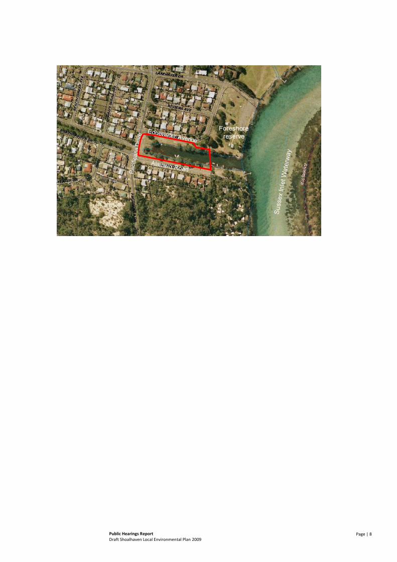
Lot 35 DP 226342 - Edgewater Avenue, Sussex Inlet
The site forms part of a drainage canal and larger foreshore reserve area that has a frontage to the Sussex Inlet waterway. The site is bounded by public roads on three sides, being Edgewater Avenue, Pacificana Drive and Alamein Road, and is identified in the aerial photo below. The site is partly underwater, providing access for boats to the adjoining Sussex Inlet waterway. The site is understood to have been acquired by Council through subdivision of the area. The intention of the reclassification from community to operational land is to implement improved canal management through the licensing of the existing jetties and moorings.
Council has previously dealt with the land and undertaken public consultation in relation to the matter. With respect to this site, Council, at its meeting of 29th November 2005, resolved as follows:
a) Council resolve to prepare a Draft Local Environmental Plan to reclassify under the Local Government Act that part of Lot 35 DP 226342 (Alamein drainage canal) comprising of land from the road reserve to the mean high water from community to operational land
b) Council endeavour to achieve the reclassification as part of a Draft Local Environmental Plan that includes other reclassification or special use issues.
c) Council support in principle the preparation of a Management Plan for the Alamein drainage canal that would allow for the provision of long term licensing of jetties and moorings at this location only with the cost of construction of jetties being met by the licensee.
d) Preparation of a management plan for the canal be deferred pending Council’s successful rezoning application
e) Council endorse that action be taken to remove the public liability risk associated with jetties in the Alamein drainage canal as outlined in the report.
Public Hearings ReportDraft Shoalhaven Local Environmental Plan 2009
Page | 8

Public Hearings ReportDraft Shoalhaven Local Environmental Plan 2009
Page | 9
3. The Public Hearings
Two Public Hearings were undertaken in respect of the land parcels. These were as follows:
Public Hearing 1
Held 6:30pm on 2nd November 2011
Shoalhaven City Council Administration Centre
Bridge Road, Nowra
Public Hearing 2
Held 6:30pm on 3rd November 2011
Vincentia Community Hall
The Wool Road, Vincentia
At each Public Hearing, the need for and purpose of the meetings were outlined in a presentation, along with details of each site. Each Public Hearing focused on the land parcels that were geographically closer to the location of the Hearing as follows:
Public Hearing 1 at Nowra focused on the following land proposed for reclassification:
o Lot 21 DP 252281 - Shoalhaven Heads Road, Shoalhaven Heads
o Lot 12 DP 617101 - Bolong Road, Coolangatta
o Lot 3 DP597223 - Bolong Road, Coolangatta
Public Hearing 2 at Vincentia focused on the following land proposed for reclassification:
o Lot 2081 DP 216860 - Lively Street, Vincentia
o Lot 4 DP 550354 - Island Point Road, St Georges Basin
o Lot 35 DP 226342 - Edgewater Avenue, Sussex Inlet
At each Public Hearing, the attendees were made aware that six parcels were proposed to be reclassified and detail offered on the land that was not the focus of the relevant Public Hearing.
A total of three residents attended Public Hearing 1, and nine attended Public Hearing 2.
Table 1 provides a record of comments and questions received with respect to each site or at the conclusion of the entire presentation.
Table 1: Public Hearings - Summary of Comments and Questions
Site Comments or Question Response
Lot 21 DP 252281 - Shoalhaven Heads Road, Shoalhaven Heads
Around 2008 Council sought to reclassify a number of sites in Shoalhaven Heads. What happened to the other parcels?
(From Council) Council withdrew the proposal as the community did not agree with reclassification of most of the sites with the exception of the one being discussed tonight. Council is undertaking a further review of Council owned land upon completion of the current LEP.

Public Hearings ReportDraft Shoalhaven Local Environmental Plan 2009
Page | 10
Site Comments or Question Response
Will the proceeds from any sale be returned to the Shoalhaven Heads area?
(From Council) Should the site be reclassified and sold, Council will determine how the proceeds are allocated. This hasn’t been determined yet.
Does it matter that a resident gave that land to the community in the first place?
(From Council) How Council acquired the land and how it is subsequently used is considered. The fact that the land isn’t currently used by the general community and not of any benefit to the general community is important.
What is the process for selling the land? (From Council) Council’s Property Unit would undertake a process of sale which is believed to typically involve a tender or expression of interest (EOI) process. This process would be subject to future decisions of Council.
Lot 12 DP 617101 - Bolong Road, Coolangatta
No comments or questions received -
Lot 3 DP597223 -Bolong Road, Coolangatta
No comments or questions received -
General Comments from Public Hearing 1
Will you send out the report to meeting attendees?
(From Council) The report will be emailed or posted to attendees when available.
Basically nothing is going to happen if the LEP is going to be at least 6 months away?
(From Council) The sale process, if Council proceeds in that direction, cannot occur until the LEP is gazetted. That is likely to be at least six months away.
Does State Government need to approve the reclassification?
(From Council) The State Government approves/endorses the LEP, but are unlikely to change the reclassification aspects as they already certified the plan for exhibition.
Lot 2081 DP 216860 - Lively Street, Vincentia
Why do we need to give access to the residents when they have access from Frederick Street?
(From Council) Council received a request from a landowner to formalise access. Council resolved to undertake the reclassification process for the land.
If this goes through, does this mean Council will spend money to upgrade as it is in very poor condition?
(From Council) This is something that Council will have to consider. (Note - Council’s resolution on the matter identifies that all costs would need to be met by benefitting land owners)
Isn’t it a fire trail? (From Council) The site does act as a fire trail.
It is impossible to get to the larger part of the parcel as there is a drain blocking access – it is a very inaccessible block.
(From Council) Council resolution on the matter only identifies the narrow part of the site for reclassification, excluding access to the larger part of the site.
Has national parks considered acquiring the land? (From Council) It is not believed that any formal approach has been made.
Adjoining crown land is zoned E2, is RE1 suitable? (From Council) An E zone may be possible, but RE1 was the “best fit” transfer from the previous LEP.
Public Hearings ReportDraft Shoalhaven Local Environmental Plan 2009
Page | 11
Site Comments or Question Response
Can’t you leave it as community land and still grant access?
Isn’t it also a liability issue for Council?
Why can’t you leave it as is? It has been used informally for 15 years, why not leave it as is?
(from Council) Council would like to formalise the current arrangement to ensure the area is appropriately managed.
It seems like the effort and cost is not really worth it. Why would you want rear access anyway and the access is already there?
If it becomes proper road, people will start parking in there.
People have their gardens extending into the area, it is nice as it is.
Seems like a wasted project, would like it left as it is.
(General comments noted)
Lot 4 DP 550354 -Island Point Road, St Georges Basin
Is there any access to the land? (From Chair) The only way for the public to access the land is from the water.
Is there a commercial zone over the adjoining lots? (From Council) Yes, the adjoining lots are proposed to transfer from the 3(g) zone to the B4 Mixed Use zone in the new LEP.
Believes that Council need to look long term and not reclassify the land but continue to work towards acquiring all of the foreshore area to create public access along the foreshore.
(Comment noted)
Public land provides for protection against sea level rise which is expected to occur in this location.
(Comment noted)
Should look at a contribution plan to acquire the land over time.
(From Council) No plan is currently in place for this location.
Adjoining owner who is not willing to sell any of his land. Did not want the 3(g) zoning and Council has done nothing with the land since this change.
(From Council) Explained that Council sets the zones but it is up to the landowner to develop their land. Just because the land has not been developed yet, there is still the potential to have development to occur.
What was the original purpose of acquiring the land in the first place?
(From Council) Understood to be part of a long-term plan to enable foreshore access for the public.
There is a perception in the community that Council intends to acquire land to create a foreshore reserve along St Georges Basin. It is recognised that this will take time and may not be realised in our lifetime.
(Comment noted)
If the land is sold, it will be sold for very little and an opportunity will be lost.
(Comment noted)

Public Hearings ReportDraft Shoalhaven Local Environmental Plan 2009
Page | 12
Site Comments or Question Response
The community has an expectation that in the future there will be access along the foreshore. Any existing access is currently very well used by the community.
(Comment noted)
In their submission, the Basin Forum requested that a contribution plan be put in place to acquire it. The intent is not that landowners lose out financially.
(Comment noted)
It is only a small parcel of land. Can’t imagine how Council could achieve access to it. It is not useful for anyone and Council can’t get in and maintain it.
(Comment noted)
Has anyone come forward asking to buy the land? (From Council) Yes, there has been an approach by an adjoining land owner.
If it is sold, it will set precedence. (Comment noted)
What is the process for the sale of the land? Can a group acquire it?
(From Council) The process would typically be notified and negotiations held with Council’s Property Unit.
Lot 35 DP 226342 - Edgewater Avenue, Sussex Inlet
Is the land to be reclassified just the land around the water?
(From Council) No, it is the whole parcel as it is a ‘drainage reserve’ so the water itself is still treated as a reserve.
As a matter of principle, it is Community Land and it should stay that way. It is an individual personal who will gain from Community Land for people who have done the wrong thing.
(From Council) Council is looking at putting in more structures that can be leased to multiple users in the community.
If people were to walk on the jetties, would the owners be able to tell them to leave?
(From Council) No, it is public land. Issue is liability potential should someone be injured on them. If Council licences them, they can ensure that they are maintained and safe.
Private structures are not appropriate on public land. Council should not be rewarding people who are doing the wrong thing. This happens too often in the Shoalhaven.
(Comment noted)
What does Council intend to do? (From Council) There were three options reported to Council:
1. remove unauthorised structures
2. build public structures for all the community
3. keep those existing structures that are there and make them Council assets and possibly lease them.
If you were to get the owners to remove them, how would you identify the owners?
(From Council) Council does know some of the owners and can ask them to remove the structures. Council also has the ability to remove the structures without the owner’s consent.
Public Hearings ReportDraft Shoalhaven Local Environmental Plan 2009
Page | 13
Site Comments or Question Response
General Comments from Public Hearing 2
Concerned that this public hearing has been poorly notified – it was in the paper but not even the Forum was notified.
(From Council) Acknowledges that more could always be done, but Council has fulfilled the legal requirements.
(From Chair) Please also remember that this is just the reclassification process, not to sell the land. There is a further process that Council has to follow to sell the land.

Public Hearings ReportDraft Shoalhaven Local Environmental Plan 2009
Page | 14
4. LEP Submissions
In addition to the Public Hearings recorded in Section 3, this report also considers relevant submissions made in relation to SLEP 2009 as part of the broader exhibition period. Table 2 provides a summary of the two submissions received1.
Table 2: LEP Submissions - Summary of Submissions Received
Site Submission Summary
Lot 21 DP 252281 -Shoalhaven Heads Road, Shoalhaven Heads
No submissions
Lot 12 DP 617101 - Bolong Road, Coolangatta
No submissions
Lot 3 DP597223 - Bolong Road, Coolangatta
No submissions
Lot 2081 DP 216860 -Lively Street, Vincentia
Request that any reclassification be considered within the context of a review of the generic Natural Areas Plan of Management. The site is art of Bristle Bird habitat and in a sensitive coastal location.
Lot 4 DP 550354 - Island Point Road, St Georges Basin
Does not support the reclassification. The land forms part of a broader plan to provide public foreshore access. Acquisition of this foreshore link needs to remain a goal for Council and to be included in a Section 94 plan for the area.
Lot 35 DP 226342 -Edgewater Avenue, Sussex Inlet
No submissions
1 Council staff have reviewed all SLEP 2009 submissions and provided the relevant submissions to Locale Consulting.

Public Hearings ReportDraft Shoalhaven Local Environmental Plan 2009
Page | 15
5. Findings and Recommendations
Based on the comments received during the Public Hearings, review of relevant submissions to SLEP 2009, and the individual context and history of each site, the followings finding and recommendations are made:
Lot 21 DP 252281 - Shoalhaven Heads Road, Shoalhaven Heads
The site has no practical public use. While public access may be possible, there would be concerns about a public park being located in a concealed location with limited passive surveillance. There is no reported community opposition to the reclassification and interest has been expressed by adjoining land owners in acquiring the land. As per previous commitments of Council with respect to the sale of public lands in Shoalhaven Heads, it is appropriate that any funds raised be allocated to projects within the community.
Recommendation: That the site be reclassified from community to operational land
Lot 12 DP 617101 - Bolong Road, Coolangatta
The site has no practical public use. The setting on a busy road is not attractive for, and the land size/shape to practical for, any public purpose such as a public park. No submissions or comments were received in relation to the site.
Recommendation: That the site be reclassified from community to operational land
Lot 3 DP597223 - Bolong Road, Coolangatta
The site has no practical public use. The setting on a busy road is not attractive for, and the land size/shape to practical for, any public purpose such as a public park. No submissions or comments were received in relation to the site.
Recommendation: That the site be reclassified from community to operational land
Lot 2081 DP 216860 - Lively Street, Vincentia
Part of the subject land is currently used to provide rear access to existing residential dwellings. One dwelling utilises the land as a primary access. Concern was raised during Public Hearing 2 that the land would be used to provide access to new development to the rear of dwellings on Frederick Street and that the access would be formalised into a “street”. Further concern was raised about the accessibility of the land further into the site, which is noted in a submission to Draft SLEP 2009 as being protected Bristle Bird Habitat.
It is noted that Council’s original intention for the reclassification (as per Council resolution of 29th November 2005) was to limited the extent of operational land to that narrow area to the rear of 83-109 Frederick Street. This approach of a split classification is considered to be appropriate given the topography of the site and the integration of the western portion of the site with the Jervis Bay National Park. Furthermore, it should be ensured that adjoining dwellings maintain their primary legal access from existing locations and that any licensing agreement be made on such terms.

Public Hearings ReportDraft Shoalhaven Local Environmental Plan 2009
Page | 16
Recommendations:
i. That part of the site, being that part to the rear of 83-109 Frederick Street and 7 Sutton Street, be reclassified from community to operational land, with the remainder being retained as community land;
ii. That any licensing or lease agreement to formalise access include requirements that the primary property access remain from existing legal means, and that the access be for secondary purposes only; and
iii. That any costs associated with the maintenance and/or upgrade to the access be at the cost of those who benefit from the access.
Lot 4 DP 550354 - Island Point Road, St Georges Basin
The site in its present form has no practical public use being isolated from other public land. While the site is accessible by water, it is difficult to identify the land as public land as it appears as private land. The size of the land parcel does not present any significant public use opportunities. These constraints to the site were raised at Public Hearing 2.
Nevertheless, as was also identified at Public Hearing 2 and through submissions to SLEP 2009, the site does have the potential to form part of a public foreshore space extending from the boat ramp area at the end of Island Point Road through to a connection back to existing public land at Loralyn Avenue. This connection could, forexample, extend for the length of the proposed B4 Mixed Use zone area, and form part of a development control plan (DCP)/Section 94 plan for this area to facilitate orderly redevelopment.
Whilst this opportunity is recognised, there is no current DCP or other policy over the area and no known current Council direction to support the provision of public access along this area of foreshore. Without such a policy and direction of Council, the retention of the site as community land would not, on balance, be considered necessary.
Recommendations:
i. That, in the absence of a dedicated direction for the subject land, the site be reclassified from community to operational land.
Or, should Council wish to pursue the longer term objective of public access along this foreshore:
ii. That the site be retained as community land; and iii. To support the objective of providing public foreshore access, Council prepare a DCP and Section 94
plan to facilitate the orderly development of the area proposed to be zoned B4 - Mixed Use under Draft SLEP 2009
Lot 35 DP 226342 - Edgewater Avenue, Sussex Inlet
The site currently contains jetties and moorings which are privately constructed and subject to private use. Whilst the provision of private jetties from (and on) public land is not supported by Council in the current Wharves and Jetties Policy, Council has sought to control and monitor the site through the reclassification of the land and subsequent licensing of the existing facilities.
While no residents or parties with a direct interest in this matter attended the Public Hearings, comments were made at Public Hearing 2 that the provision of private structures on public land was not supported. This is a position that is consistent with Council’s existing Wharves and Jetties Policy.
Nevertheless, at the Council meeting of 28 November 2006, Council resolved to seek reclassification of the land with a view to establishing a Management Plan to control the use of the canal. Council acknowledged the inconsistency with the Wharves and Jetties Policy and sought to address this subject to the successful

Public Hearings ReportDraft Shoalhaven Local Environmental Plan 2009
Page | 17
reclassification of the land. Public consultation at that time also provided significant support for the proposal. Given this existing consultation with the affected community, and in the absence of any direct comment from the affected community in respect of this reclassification process, the direction as expressed by the existing Council resolution is considered, on balance, to be an acceptable way forward.
Recommendations:
i. That part of the site be reclassified from community to operational land in accordance with Council’s resolution of 28 November 2006; and
ii. That Council develop a Management Plan for the site, including appropriate public consultation, that addresses the need for equitable access to the proposed facilities, consistent with the resolution of Council from 28 November 2006.

Locale Consulting Pty Ltd
Report on Public Hearings - Draft Shoalhaven Local Environmental Plan 2009Report prepared by Steve Thompson (B EnvPlan (Hons) MPIA CPP)
Issued – 09 December 2011
33 River Road Shoalhaven Heads NSW 2535t: (02) 44485937 e: [email protected] w: localeconsulting.com.au
This document is and shall remain the property of Locale Consulting Pty Ltd. The document may only be used for the purpose for which it was commissioned and in accordance with the Terms of Engagement for the commission. Unauthorised use of this document in any form whatsoever is prohibited.


