62
page 1 draft PRECINCT PLAN SIMONDIUM RURAL SETTLEMENT March 2014

page 1
draft PRECINCT PLAN
SIMONDIUM RURAL SETTLEMENT
March 2014

page 2

page 3
draft PRECINCT PLAN
SIMONDIUM RURAL SETTLEMENT
March 2014
CNdV africa (Pty) Ltdenvironmental planning, urban design, landscape architecture
17 New Church Street Cape Town 8000Tel; 021 424-5022 Fax: 021 424-6837
Drakenstein Municipality 3rd Floor, 1 Market Street, Paarl 7646
Tel. (021) 807-48349 Fax: 021 870-1523
by
prepared for

page 4

SIMONDIUM PRECINCT PLANCNdV africa (Pty) Ltd
8 April 2014
page 5
CONTENTS
1. INTRODUCTION
1.1 Purpose of Report
1.2 Background
1.3 Structure
2. OPPORTUNITES AND CONTRAINTS
2.1 Whole Precinct and Surrounds
2.2 Node
3. SUSTAINABLE FUTURE
3.1 Whole Precinct
3.2 Node
4. PREFERRED DEVELOPMENT OPTIONS
5. SHORT-TERM DEVELOPMENT OPTION
6. MEDIUM-TERM DEVELOPMENT OPTION
7. LONG-TERM DEVELOPMENT OPTION
8. THE IMPLEMENTATION FRAMEWORK
8.1 Strategies And Policies To Implement The Framework
8.2 Configure Sector Plans
8.3 Recommend Revision Of Existing Policies
8.4 Sector Proposals
8.5 Linkages Between Urban And Rural
8.6 Sustainable Land For Production
8.7 Capital Expenditure Framework
8.8 Monitoring And Evaluation

page 6

page 7
SIMONDIUM PRECINCT PLANCNdV africa (Pty) Ltd
8 April 2014
1.1 Purpose of Report
• The purpose of this report is to describe the preferred developmentoptions for the future development of Simondium precinct and thesub-node that have transpired from the various stakeholderengagements that took place during the Precinct Plan: ScenariosPublic Consultation Phase.
• The report forms part of the Conceptual Development Frameworkstage in the process of preparing the precinct plan, see Figure 1.1.
1.2 Background
• Simondium is a rural precinct in the extreme south of Drakensteinmunicipality abutting the Stellenbosch municipal boundary.
• It has been the subject of a number of previous policy plans includingthe 2009 Drakenstein SDF. These generally focused on proposing anurban edge in three sub-areas in the general vicinity of the Klapmutsand Bien Donne road intersections with the R45.
• The Drakenstein Local Municipality commissioned this precinct plan toprovide policy guidelines to address a number of issues including:
- Pressure for housing from low income communities living in theprecinct and focussed around the Bien Donne road/R45intersection;
- The rich tourist resources created by the scenery, prestigious winefarms and the passing traffic to the draw card of Franschhoek.
1.3 Structure
Note: The document investigates two levels of detail:
The precinct as a whole and the node.
Annexure A lists the various comments received during the Precinct Plan:Scenarios Public Consultation Phase.
Section 2 summarises the opportunities and constraints informing theprecinct plan.
Sections 4 - 7 describes the preferred development options and the wayforward per development option.
Figure 1.1 Phases in the process of completing an, SDF (source: DEADP2010)
…… 1INTRODUCTION

page 8
SIMONDIUM PRECINCT PLANCNdV africa (Pty) Ltd
8 April 2014
Figure 1.2 illustrates the strategy and process followed to involve decisionmakers in the formulation of the Simondium Rural Precinct Plan.
The community was engaged at two strategic stages in the process:
Firstly, at the initial spatial vision and issues workshops. These were held inSimondium and were attended by a wide socio-economic cross-section ofthe community.
Secondly, the concept framework for Simondium as a whole and the nodewas workshopped with the community and I&APs.
Figure 1.2 Involvement of Stakeholders
START UP PHASE
Vision and Issues Workshop
Status Quo
Draft Precinct Plan
Final Precinct plan (Preferred
Development Options)
Project Notification and Invitation to Attend Workshop
April 2013
Councillors, members of thepublic invited
29 April 201321 May 2013
Presentation and feedback to Officials
5 July 2013
Councillors, Members of the Public
11 November 201319 November 2013
IDP Representative Forum
7 April 2014
1INTRODUCTION

page 9
SIMONDIUM PRECINCT PLANCNdV africa (Pty) Ltd
8 April 20142.1WHOLE PRECINCT: OPPORTUNITIES AND CONSTRAINTS: AERIAL PHOTO

page 10
SIMONDIUM PRECINCT PLANCNdV africa (Pty) Ltd
8 April 20142.1.1WHOLE PRECINCT: OPPORTUNITIES AND CONSTRAINTS: SITE PHOTOS
Precinct gateway: R45 rail over road bridge Prestigious wine estates Staff housing alongside R45
Cellar fronting Winelands estate retaining sense of placeWinelands estate: Tuscan architectural themeEntrance to Sante Resort
Macmillan Brickfields: historic chimney R45 lacking cycle lanes and shoulders Simonsvlei Road

page 11
SIMONDIUM PRECINCT PLANCNdV africa (Pty) Ltd
8 April 20142.1.2WHOLE PRECINCT: OPPORTUNITIES AND CONSTRAINTS: EXISTING TOURISM
Simondium: Bien Donne: ABSA Cape Epic 2013: Stage 6
Klein Drakenstein Mountains
Simonsberg Mountains

page 12
SIMONDIUM PRECINCT PLANCNdV africa (Pty) Ltd
8 April 2014
OPPORTUNITIES
• Good transport connections
- Enjoys good access from N1 national route to the north fromKlapmuts and Paarl intersections along the Klapmuts road whichintersects with the R45 at Simondium node;
- The R310 from Stellenbosch (Helshoogte Pass) through the DwarsRiver Valley intersects with the R45 approximately 2km to the southat Groot Drakenstein – a node that has some of the facilities usedby the Simondium residents such as the police station;
- A hop-on hop-off tourist tram service plies between Franschhoekand Wemmershoek. This service could be extended throughSimondium; and,
- If successful it could also start to provide a commuter service inaddition to its tourist role.
• Scenic and agricultural resources
- The Simondium precinct landscape comprises a rich mosaic of rivercorridors and vineyards on the lower slopes towards the Berg riverforming the eastern boundary which then rises westwards to theSimonsberg which forms a dramatic spine along the boundary withStellenbosch municipality;
- There has been a considerable investment in irrigation infrastructurein the form of dams, canals and pipe networks over the years;
- The higher slopes comprise private and public nature reserves andensure that at least the high river catchments are protected;
- This northwest facing landscape has proved desirable on aninternational scale attracting both overseas tourists and investors;
- The tourist products of these prestigious operations, restaurants andwine sales and increasingly adventure sports such as trail runningand mountain biking are providing year round employment andeconomic activity with bookings required to many of the restaurantsthrough winter as well as summer. (Note: Stage 6 of the 2013 ABSACape Epic passed through Bien Donne en route from Wellington toStellenbosch); and,
- According to the National Development Plan, both agriculture andtourism are set to become key long term drivers of both economicgrowth and employment. The precinct would appear to be wellpositioned in this regard providing its scenic, agricultural and touristresources are protected.
2.1.3WHOLE PRECINCT: OPPORTUNITIES AND CONSTRAINTS
CONSTRAINTS
• Road system
- The road system is currently designed to facilitate regional vehicletraffic and there are no cycle lanes although there is a pedestriansidewalk along the east verge of the R45 between the church andnode intersections. It is the 7th most dangerous road in the province;
- The upgraded R310 between Groot Drakenstein and Pniel offersuseful precedent as to how a rural arterial route can offer nonmotorised transport facilities without unduly affecting its mobilityfunctions; and,
- Some of the gravel roads, especially the Simonsvlei road, are inpoor quality.
• Water quality
- Although most of the high catchments in the precinct are wellprotected, problems are experienced as these tributaries flow intothe Berg river which itself is a continual cause of concern due itspoor water quality; and,
- There is a continuous threat of irrigation farmers losing their exportstatus due to issues around water quality. Better protection of thelower reaches of rivers and water courses is required.
• Housing
- As a result of the general effects of policies around the tenure offarmworkers and current aspirations towards non-agricultural futuresof many residents, there has been an increase in the numbers ofpeople seeking off farm accommodation. This has resulted in asmall but long standing informal settlement in the Simondium nodeand considerable pressure for housing; and,
- There is a lack of clarity around the exact dimensions of thischallenges in terms of project options – e.g. a large project wasproposed at nearby Meerlust in Stellenbosch municipality , theactual numbers of households requiring housing (ranges from 50 –1000), availability of services and the necessary funding, and thealignment of the municipal boundary.

page 13
SIMONDIUM PRECINCT PLANCNdV africa (Pty) Ltd
8 April 20142.1.4WHOLE PRECINCT: OPPORTUNITIES AND CONSTRAINTS

page 14
SIMONDIUM PRECINCT PLANCNdV africa (Pty) Ltd
8 April 20142.2NODE: OPPORTUNITIES AND CONSTRAINTS: AERIAL PHOTO

page 15
SIMONDIUM PRECINCT PLANCNdV africa (Pty) Ltd
8 April 20142.2.1NODE: OPPORTUNITIES AND CONSTRAINTS: SITE PHOTOS
Stellenpak – major employment centre Mission church: landmark gateway corner Simondium Church: Cape Dutch Art Deco
Outspan in front of Simondium Primary School Informal settlement near cemetery Shop and service station south of Wintergat / R45
Service station and shop north of Wintergat / R45 Fallow land and street lit sidewalk along R45 between Wintergat / R45 and post office Shop and post office with residential above

page 16
SIMONDIUM PRECINCT PLANCNdV africa (Pty) Ltd
8 April 2014
OPPORTUNITIES
• Landmark gateway from Klapmuts and Paarl comprising MissionChurch and Vrede-en-Lust Wine tasting and restaurant;
• Located on R45 at junction with Klapmuts Road intercepting trafficflows from N1 west (from Cape Town) and N1 north (from Cape Town<Paarl and from the east over the Hottentots Holland (Breede Valley toGauteng);
• Currently defunct Franschhoek rail line passes nearby – the southernsection from Lategan station to Franschhoek (outside of the study areaand Drakenstein Municipality) is currently being operated by a touristtram service – this could be extended northwards to Paarl;
• Well served by community facilities, public and private primary schools,clinic, shops, and two service stations around the Watergat Road/R45junction. There is a post office/shop and pension pay out further southalong the R45 just inside the municipal boundary;
• The area surrounding the node is generally well treed and there is thebeginning of an eucalyptus avenue around Simondium primary school;
• There are major employers in the area including the GovernmentResearch farm at Bien Donne, various wineries and pack sheds ofwhich one of the largest is Stellenpak, and surrounding wine farms withtheir restaurants and overnight accommodation; and,
• The latter are responsible for attracting international and local touristsinto the area which can create further business opportunities for smallscale formal and informal retail businesses, of which there some of theformer existing, and the latter which could be promoted through anappropriately located and easily accessible periodic craft andfarmers’ market. For instance this could operate over the weekendswhen there is a higher influx of day trippers and weekend getaways into the sub-region, or on a midweek basis coinciding with whenpensions are paid.
2.2.2NODE: OPPORTUNITIES AND CONSTRAINTS
CONSTRAINTS
• The node is rather spread out in a series of sub-nodes with distance ofbetween 1 km and 1.5 kms between them;
• These are long pedestrian walking distances (excess of 20 minutes)although they have been facilitated to some extent by a street litsidewalk between the Watergat road intersection and the post office;
• While further tree planting with preferably indigenous trees should bepromoted careful thought to the extent of flooding, if any, that mayresult from the removal of mature eucalyptus trees;
• This section of the R45 is the 7th highest accident frequency in theprovince and care must be taken with the design of future upgradesand the provision of pedestrian, cycling and public transport facilities;
• An important consideration will be to keep as much futuredevelopment on the east side of the R45 as possible so as to limit theneed for vehicle and particularly pedestrian crossings;
• Other complimentary community facilities such a high school andpolice station are found outside of the area. There is a police station atGroot Drakenstein, approximately 4kms away in neighbouringStellenbosch municipality, and there is an upmarket private highschool at Bridgehouse towards Franschhoek. Public high schools arefound in Paarl only accessible by private motor vehicles or publictransport; and,
• There is currently vacant land around the informal settlements near thecemetery along the Watergat road but the use of this land, and othernearby properties identified for evaluation in the past are currentlyconstrained by a 500 m zone contained in National Department ofHealth regulations regarding land use management aroundcemeteries. This regulation was only promulgated in the 1st half of 2013and there does not appear to have been consultation with relevantstakeholders. A process has begun to have this regulation amended.

page 17
SIMONDIUM PRECINCT PLANCNdV africa (Pty) Ltd
8 April 20142.2.3NODE: OPPORTUNITIES AND CONSTRAINTS
page 18
SIMONDIUM PRECINCT PLANCNdV africa (Pty) Ltd
8 April 20143SUSTAINABLE FUTURE

page 19
SIMONDIUM PRECINCT PLANCNdV africa (Pty) Ltd
8 April 20143.1WHOLE PRECINCT: SUSTAINABLE FUTURE

page 20
SIMONDIUM PRECINCT PLANCNdV africa (Pty) Ltd
8 April 20143.1.1WHOLE PRECINCT: SUSTAINABLE FUTURE: PHOTO SHEET
Precinct’s regional tourism profile
://www.google.co.za/imgres?start=295&um=1
&hl=en&biw=1179&bih=899&tbm=isch&tbnid=
4vM0VsXZn-
ONnM:&imgrefurl=http://www.winchester.co.z
a/&docid=8eMlbiLXoi5VdM&imgurl=http://w
ww.winchester.co.za/files/Home/Tripadvisor_T
ravellers_Choice_Winner_2013_1.jpg&w=712&
h=765&ei=LLUpUpebIuWv0QXq8IHQBA&zoom
=1&ved=1t:3588,r:6,s:300,i:22&iact=rc&page=1
4&tbnh=211&tbnw=197&ndsp=25&tx=103&ty=
68
Municipality (LED) and tourism bodies promoted Organic, off-grid resource wise farming promoted
Tourist tram service extended to Paarl and includes community function Local businesses promoted
http://www.google.co.za/imgres?st
art=250&um=1&hl=en&biw=1179&bi
h=899&tbm=isch&tbnid=tdQ9uObh
C7JkPM:&imgrefurl=http://www.coo
kfranschhoek.co.za/&docid=vhX2w
HLNlHmvYM&imgurl=http://tamaleki
.typepad.com/.a/6a0162fffe844e97
0d01901cf8da95970b-
800wi&w=800&h=273&ei=6bUpUsa-
CeqQ0QXo_YGYAg&zoom=1&ved=
1t:3588,r:67,s:200,i:205&iact=rc&pag
e=11&tbnh=131&tbnw=347&ndsp=2
6&tx=179&ty=80
Continuous network of cycleways along Regional routes (R310 Pniel)Recreational and commuter road cycling
Local businesses promoted http://www.agrimega.co.za/article.php?art_id=39
Continuous mountain to river network

page 21
SIMONDIUM PRECINCT PLANCNdV africa (Pty) Ltd
8 April 20143.1.2WHOLE PRECINCT: SUSTAINABLE FUTURE: RUNNING, WALKING AND MTB, TRAIL
Linking trail systems between mountains and valleys

page 22
SIMONDIUM PRECINCT PLANCNdV africa (Pty) Ltd
8 April 2014
• The municipality is hard pressed to fund and manage its servicedelivery challenges in its existing built up urban areas and has tochannel all of its available resources in this direction. It is not able tofully service outlying rural areas;
• This implies that any development in the area must rely on off-gridservice technologies;
• Access to economic opportunities is seen as paramount, especially foremerging business people and it is vitally important to give themaccess to good trading locations if they are to become financiallysustainable. This implies locations closer to rather than further awayfrom the R45;
• However, it will also be important to preserve the mobility function ofthe R45 as it passes through Simondium;
• The key drivers of agriculture and tourism identified in the NDP manifestthemselves strongly and those areas or sub-regions with the naturalresources to serve these demands should position themselves asstrongly as possible;
• A major advantage of these two sectors is that, unlike especiallyresidential, as opposed to industrial, retail or commercial property,development, they provide long term income flows and employmentcreation so that they are able to provide on going livelihoods;
• Simondium precinct west of the Berg River is probably, for its size, oneof the best endowed regions in South Africa in terms of agricultural,heritage, scenic and tourist resources and their very powerfuloverlapping combination through agri-tourism;
• These advantages are further compounded by the precinct’s strategiclocation on the R45 carrying all of the tourist traffic to Franschhoek withits winter festivals and summer tourist appeal;
• In terms of addressing the challenges of emerging South Africa thesub-region is also enjoying success through ventures such as Museumvan de Caab at Solms Delta, a kilometre away from the precinct inGroot Drakenstein as well as the Reuben’s group of restaurants.Tourism activities within the study area include restaurants & winemaking at Anura, Backsberg, Glen Carlou, Noble Hill, Vrede & Lust(Babylonstoren & Plaisir de Merle, wine cellars only) as well as the LeBonheur Crocodile Farm, Cathbert Country Inn, Simondium CountryLodge, Santé Hotel Spa & Resort, Klein Waterval Riverside Lodge,Wilderer Distillery & Ristorante and Marlenique Wedding Venue; and,
• Preserving the precinct’s natural assets particularly those linked toagriculture, i.e. protection of arable land and water quality andquantity will also be important.
This leads to the following proposals for the precinct scale:
3.1.3WHOLE PRECINCT: SUSTAINABLE FUTURE
• Create a contiguous green network based on river corridors linking theBerg River to the Simonsberg;
• Extend where possible the riparian width of these corridors to 32 meither side of the banks in which there should be no buildings orploughing and natural vegetation protected or rehabilitated;
• Extend the formal nature reserves on the Simonsberg down the lowerslopes to protect remnants of Critically Endangered or Endangeredvegetation;
• Encourage bringing back into production fallow land either throughcommercial agricultural or through bona fide land reform projects;
• Protect agricultural land from any further subdivision in urban townshipsor small holding areas;
• Intensify, promote and facilitate the tourism business potential of thevarious farms and other attractions in the precinct through regionaltourism promotion by the municipality or tourist bureau;
• Support further short term accommodation on the farms within thelimits of the current building footprints including conversion oflabourers cottage vacated by staff moving to town although becareful of unintended consequences such as evictions;
• Reconfigure the regional routes to form a continuous network similar tothat of the R310 Helshoogte Road between Pniel and GrootDrakenstein so as to promote commuter cycling as well as recreationalcycling along rural roads with safe pedestrian sidewalks and tree linedavenues – taking care that the latter do not obscure views of thesurrounding mountains to passers by;
• An important new link in this regional route network is the proposed linkfrom the R310 across the Berg river at Bien Donne past NelsonMandelas’s prison house at Drakenstein Prison to the Watergat Roadand eventually to its intersection on the R45. Careful considerationmust be given to the heritage value of the area surrounding theMandela house prison itself when the link is constructed;
• This link will also facilitate a trail running and MTB link between theGroot Drakenstein Mountains to the west and Simonsberg to the east;
• Mountain biking is becoming an increasingly important tourismopportunity and represents a new market for accommodation andeating out. Each of the major wine farms could offer shower facilities,bike wash areas and safe parking. This is currently being implementedby groups of nearby wine farmers in conjunction with professional MTBtrail managers elsewhere in the Boland.

page 23
SIMONDIUM PRECINCT PLANCNdV africa (Pty) Ltd
8 April 20143.1.4WHOLE PRECINCT: SUSTAINABLE FUTURE

page 24
SIMONDIUM PRECINCT PLANCNdV africa (Pty) Ltd
8 April 20143.2NODE: SUSTAINABLE FUTURE

page 25
SIMONDIUM PRECINCT PLANCNdV africa (Pty) Ltd
8 April 20143.2.1PRECEDENT: SOCIO-ECONOMIC INTEGRATION: LANGEBAAN
Mixed use market housing along major route through to site and service near food gardens
Well-located BNG housing project in Langebaan surrounded by up-market housing
Principle of socio-economic gradient
Careful design of BNG housing (Langebaan, West Coast)
page 26
SIMONDIUM PRECINCT PLANCNdV africa (Pty) Ltd
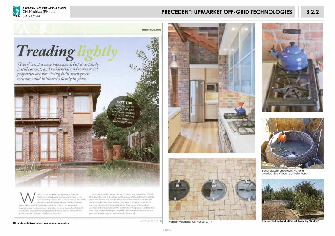
8 April 20143.2.2PRECEDENT: UPMARKET OFF-GRID TECHNOLOGIES
(Property Magazine: July-August 2011) Constructed wetland at Creset House by “Lindros”
Biogas digestor under construction at Lynedoch Eco Village near Stellenbosch
Off-grid sanitation systems and energy recycling

page 27
SIMONDIUM PRECINCT PLANCNdV africa (Pty) Ltd
8 April 2014
In Norway construction costs of an open drainage system are 30% lower than the cost of a conventional pipe system.
3.2.3PRECEDENT: RENEWABLE ENERGY AND RAINWATER HARVESTING: SUBSIDY PROJECTS
Rainwater harvesting and filtration

page 28
SIMONDIUM PRECINCT PLANCNdV africa (Pty) Ltd
8 April 20143.2.4PRECEDENT: SUBSIDY HOUSING: OCEAN VIEW
Building GAP and BNG housing from local materials: City of Cape Town: Ocean View

page 29
SIMONDIUM PRECINCT PLANCNdV africa (Pty) Ltd
8 April 20143.2.5PRECEDENT: SUBSIDY HOUSING: MBEKWENI
Self-built houses using local materials: Mbekweni

page 30
SIMONDIUM PRECINCT PLANCNdV africa (Pty) Ltd
8 April 20143.2.6PRECEDENT: LYNEDOCH ECO VILLAGE
Lynedoch eco-village, off-grid service technologies, passive insulation
page 31
SIMONDIUM PRECINCT PLANCNdV africa (Pty) Ltd
8 April 2014
Development concept: frontage / service road
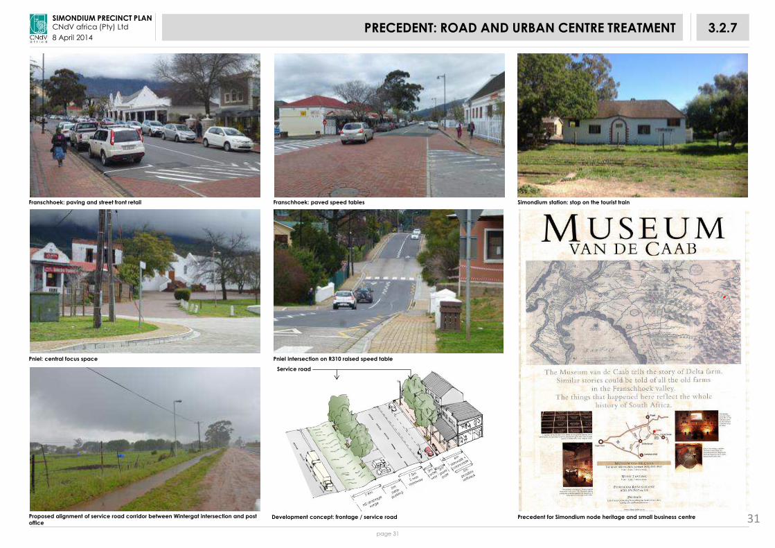
3.2.7PRECEDENT: ROAD AND URBAN CENTRE TREATMENT
Franschhoek: paving and street front retail Franschhoek: paved speed tables Simondium station: stop on the tourist train
Pniel: central focus space Pniel intersection on R310 raised speed table
Proposed alignment of service road corridor between Wintergat intersection and post
officePrecedent for Simondium node heritage and small business centre 31
Service road

page 32
SIMONDIUM PRECINCT PLANCNdV africa (Pty) Ltd
8 April 20143.2.8PERIODIC TOURISM AND CRAFT MARKETS

page 33
SIMONDIUM PRECINCT PLANCNdV africa (Pty) Ltd
8 April 2014
SIMONDIUM PRECINCT PLANCNdV africa (Pty) Ltd
8 April 2014
page 34
4PREFERRED DEVELOPMENT OPTIONS
The preferred development options include the following, see Figure 4.1 and Table 4.1.
4.1 SHORT-TERM DEVELOPMENT OPTION
Applicable properties include:
• Farm 941 Portion 4;
• Farm 1200 Portion 0;
• Erf 115;
• Erf 119;
• Farm 1200 Portion 5;
• Farm 1220 Portion 7;
• Farm 941, Portion 3;
• Farm 941 Portion 8; and,
• Farm 1222 Portion 1.
4.2 MEDIUM-TERM DEVELOPMENT OPTION:
• Farm 904 Portion 1
4.3 LONG-TERM DEVELOPMENT OPTION:
• Farm 1264

page 35
SIMONDIUM PRECINCT PLANCNdV africa (Pty) Ltd
8 April 2014
Figure
4.1PROPOSED WAY FORWARD

page 36
SIMONDIUM PRECINCT PLANCNdV africa (Pty) Ltd
8 April 2014
Table
4.1PROPOSED DEVELOPMENT OPTIONS
ScenarioFarm (if Erf then
indicated as such)Ownership
Full Extent (Hectares)
Developable Area
(Hectares)
Municipal Valuation (July
2012)Mun. actions required? Current Use
Site Suitability/ Development Potential
Land required to accommodate 700 hh at
various densities
Owner's Comment (To Follow)
Short Term(see Figure 5.1)
941/4 Drakenstein Municipality ±8,7 ±5,9Municipal property
Approach CWDM & Nat. Dept of Health for exemption, if applicable, from 500m zone, Dept. of Agriculture AND Initiate NEMA & LUPO application processes
1. Vacant1: Developable Area -
Phase I (Roll-over) 3.5Ha: 210 units
• 100m² plots @ 60du/ha = 11.67ha
• 150m² plots @ 40du/ha = 17.50ha
• 200m² plots @ 30duha= 23.33ha
• 400m² plots @ 15 du/ha = 46.67ha
2. Informal Settlement2: Redevelop after
Phase I (Phase 2) 0.77Ha: 47 units
3. Existing Cemetery and Expansion Area
4. Existing Cemetery and Expansion Area
5. Existing Trees to be Retained
1200/0 Drakenstein Municipality ±0,6 ±0,2Municipal property
Approach CWDM & Nat. Dept of Health for exemption, if applicable, from 500m zone, Dept. of Agriculture AND Initiate NEMA & LUPO application processes
A: VacantA. Develop Area with
Phase 1 (0,2 ha): 12 units
940/3 Prov. Gov. Western Cape ±2,7 ±1,3 R 6135 000Approach land owner and CWDM & Nat. Dept of Health, if applicable, for exemption from 500m zone
B: Portion of School Grounds
C: Portion of School Grounds
115 (Erf)Primary School Pierre Simond
±2,2 ±1,9R 752 500
Approach land owner and CWDM & Nat. Dept of Health, if applicable, for exemption from 500m zone
D: Vacant
E: Homestead
F: Simond Playing Field
119 (Erf)Prov. Dept. of Education-Intermediate Public School
±3,0 ±1,6 UnknownApproach land owner and CWDM & Nat. Dept of Health, if applicable, for exemption from 500m zone
Portion of School Grounds
1220/5Primary School Pierre Simond
±0,3 ±0,2R 1 032 000 (R 1 720 000 with 1220/7)
Approach land owner and CWDM & Nat. Dept of Health, if applicable, for exemption from 500m zone
Portion of School Grounds
1220/7Primary School Pierre Simond
±0,2 ±0,2R 688 000
(R 1 720 000 with 1220/5)
Approach land owner and CWDM & Nat. Dept of Health, if applicable, for exemption from 500m zone and Dept. of Agriculture
Simond Playing Field
941/3Old Apostolic Church of Africa
±0,4 ±0,2 R 790 500Approach land owner and CWDM & Nat. Dept of Health, if applicable, for exemption from 500m zone and Dept. of Agriculture
Church
941/8 Drakenstein Municipality ±0,5 ±0,5Municipal property
Approach CWDM & Nat. Dept of Health for exemption, if applicable, from 500m zone
Informal Housing
1222/1 Top Fruit (Pty) Ltd ±12.5 ±12,5 R 6 835 000Approach land owner and CWDM & Nat. Deptof Health, if applicable, for exemption from 500m zone and Dept. of Agriculture
Sub-total ± 31.1 ± 24.5
Medium Term(see Figure 6.1)
904/1Provincial Government-Western Cape [RSA] (Dept. of Public Works)
±12,7 ±12,7 R 8 605 000Approach land owner, Department of Agriculture and Department of Cultural Affairs and Sport
Bienne Donne
762 units
Sub-total ± 12,7 ± 12,7
Long Term(see Figure 7.1)
1264Abraham Johannes Goosen
± 36,5 ± 36,5 R 2 045 000 Approach land owner and Dept. of Agriculture
Sub-total ± 36,5 ± 36,5
TOTAL ± 80.3 ± 73.7
(Source: Drakenstein Municipality, October 2013)

page 37
SIMONDIUM PRECINCT PLANCNdV africa (Pty) Ltd
8 April 2014

SIMONDIUM PRECINCT PLANCNdV africa (Pty) Ltd
8 April 2014
page 38
5SHORT TERM DEVELOPMENT OPTION
Short term development option, see Figure 5.1.
1. The short term development option follows the current approach toproviding low income housing.
2. There is no clear estimate for housing need in Simondium other than the 40to 50 households living in the informal settlements. The reasons for this lackof clarity have ranged from the difficulty of dividing up the ward boundaryinto sub-enumerator districts as so to understand how many people mightlive within the Simondium study area to the fact that a number of localhouseholds have their names on multiple waiting lists.
3. Figures ranging from 200 to 1000 households have been mentioned.
4. For the purpose of this planning exercise a figure of 700 households hasbeen used. The following table shows the land required toaccommodated 700 households at different densities;
5. A number of properties in and around the cemeteries near the informalsettlements have been seen as the logical place to accommodate thishousing. With Erf 115 (school fields), Farm 4/941 (cemetery) and Farm1222/1, (intensive tunnel farming site but which had been previouslyoffered to the municipality for housing) totalling 25.7 ha) now falling within500m the cemetery residential prohibited zone according to the NationalDepartment of Health’s recently promulgated regulation (Municipality toconfirm if applicable to new / proposed or existing cemeteries);
6. The immediately developable land parcels, i.e. land parcels owned bythe Drakenstein Municipality, measures approximately 4.47ha;
7. The immediately developable land parcels are able to accommodate270 households at a plot size of 100m² with a gross density of 60du/ha.
NEXT STEPS:
• Farms 941/4 and 1200/0 are owned by the Drakenstein municipality.
• Farm 941/4:
The Municipality to proceed with the development of the immediatelydevelopable areas, see areas indicated as 1 and 2, Figure 5.1.
• Farm 1200/0:
The Municipality to proceed with the development of this site, see areamarked A, Figure 5.1.
• The Municipality should approach the following land owners: Farm 940Portion 3, Erf 115, Erf 119, Farm 1220 Portion 5, Farm 1220 Portion 7, Farm 941Portion 3 and Farm 1222 Portion 1, see Table 4.1 with the view to:
• Obtain valuations (municipal and market);
• Obtain Council in principle approval for the acquisition of the land (Motivational Report to the Facilities & Property Administration Section who in turn compiles and submits report to Council for decision-making);
• Apply for funds to procure a budget for the acquisition of land at various sources:
– Municipal budget;
– Provincial or National Government Departments;
– Development Banks; and,
– Loans at other institutions;
• Align Civil Engineering Master Planning and Housing Pipeline Projects (Drakenstein Human Settlements Department would be the driver in conjunction with the Drakenstein Civil Engineering Services Department of this housing project);
• Human Settlement Department proceed with:
– Land Use Application process; and
– Environmental Authorization Application process.
hhlds plot size m2
gross density du/ha area (ha)
700 100 60 11.67
150 40 17.50
200 30 23.33
400 15 46.67

page 39
SIMONDIUM PRECINCT PLANCNdV africa (Pty) Ltd
8 April 2014
Figure 5.1Aerial Photograph: Short Term Development OptionAerial Photograph: Short Term Development Option

SIMONDIUM PRECINCT PLANCNdV africa (Pty) Ltd
8 April 2014
page 40
6MEDIUM TERM DEVELOPMENT OPTION
Medium term development option, see Figure 6.1.
1. The medium term development option follows the current approach toproviding low income housing.
2. There is no clear estimate for housing need in Simondium other than the40 to 50 households living in the informal settlements. The reasons forthis lack of clarity have ranged from the difficulty of dividing up theward boundary into sub-enumerator districts as so to understand howmany people might live within the Simondium study area to the factthat a number of local households have their names on multiplewaiting lists.
3. Figures ranging from 200 to 1000 households have been mentioned.
4. For the purpose of this planning exercise a figure of 700 households hasbeen used. The following table shows the land required toaccommodated 700 households at different densities.
5. The site is able to accommodate 762 households at a plot size of 100m²with a gross density of 60du/ha.
NEXT STEPS:
The Municipality should approach the land owner, Department ofAgriculture and Department of Cultural Affairs and Sport with a view to:
• Obtain valuations (municipal and market);
• Obtain Council in principle approval for the acquisition of the land (Motivational Report to the Facilities & Property Administration Section who in turn compiles and submits report to Council for decision-making);
• Apply for funds to procure a budget for the acquisition of land at various sources:
– Municipal budget;
– Provincial or National Government Departments;
– Development Banks; and,
– Loans at other institutions;
• Align Civil Engineering Master Planning and Housing Pipeline Projects (Drakenstein Human Settlements Department would be the driver in conjunction with the Drakenstein Civil Engineering Services Department of this housing project);
• Human Settlement Department proceed with:
– Land Use Application process; and
– Environmental Authorization Application process.
Please note that the Drakenstein SDF is currently in a review process inwhich all Urban Edges will be revised. If the development of Farm 904/1 isto proceed in future, an Urban Edge would be deemed to enclose Farm904/1 or the relevant portion thereof.
hhlds plot size m2
gross density du/haarea (ha)
700 100 60 11.67
150 40 17.50
200 30 23.33
400 15 46.67

page 41
SIMONDIUM PRECINCT PLANCNdV africa (Pty) Ltd
8 April 2014
Figure 6.1Aerial Photograph: Medium Term Development Option

SIMONDIUM PRECINCT PLANCNdV africa (Pty) Ltd
8 April 2014
page 42
7LONG TERM DEVELOPMENT OPTION
Long term development option, see Figures 7.1 and 7.2.
1. This development option seeks to:
• Strengthen and intensity the nodes attributes, namely, its stronglandmark gateway around the Klapmuts R45 intersection byextending this quality along the R45 to the post office;
• Build on the already existing resource of community facilities and retailenterprises;
• Take advantage of the passing trade along the R45 for the benefit ofemerging formal and informal businesses as well as offer anotheropportunity to strengthen existing businesses;
• In doing so it is also important not to unduly compromise the mobilityfunction of the R45 through Simondium so as to retain its role as afreight and passenger route for businesses and residents betweenFranschhoek and the N1; Provide an opportunity to share the area’srich cultural heritage of pre-colonial and colonial history with aparticular emphasis on those histories hitherto little heard. This wouldseek to broaden the work begun at Solms Delta focussed on thehistory of that property;
• Thus the acquisition of Farm 1264 is proposed; and,
• This property fronts almost the entire distance between the post officesub-node and is currently fallow. It comprises 36.5 hectares, more thanenough land to accommodate 700 households on 150 or even 200m2plots as well as provide land for food and market gardening. Mostresidents in the area have these skills and this land would be aproductive resource.
2. The main proposals to achieve this are:
• Building on the proposal to upgrade all of the regional routes to asimilar cross section to the existing R310 Helshoogte Road throughPniel (cycleway/shoulder - roadway – cycle way/shoulder –pedestrian sidewalk) further enhance the section of the R45 passingthrough Simondium by paving across the roadways and landscapingthe verges with tree planting the following intersection:
(1) Klapmuts/R45 intersection
(2) Watergat/R45 intersection
(3) A new intersection to a frontage/service road constructedbetween Watergat road and the post office;
(4) Post office intersection;
• The spacing between these intersections should as far as possiblecomply with Provincial Department of Transport’s Road AccessManagement Guidelines (1996); and,
• This requires full access local intersections at an 80km/h operatingspeed to be 300m (driveway), 450m (normal side street) to be apart.These intersections will be between 600m and 730m apart.
3. The main device to provide local business access to passing trade is thefrontage/service road between the Watergat/R45 intersection and thepost office. This road will be single sided with buildings facing the R45along its entire length but vehicle and pedestrian access will only bepossible at the three intersections. This will be achieved by providing atreed and fenced median as well not permitting any land use activitiesacross the R45 that would create pedestrian desire lines. Developmenton the west side of the R45 along this section should be limited to theexisting residential buildings around the proposed new intersection.
4. As part of enhancing the tourism opportunities, as well as possibly in thelong term, providing an alternative commuter transport mode it isproposed that the Franschhoek tourist tram service be extended toSimondium and ultimately all the way to Paarl. A new station is proposedat the intersection (3).
5. Development of this property should be focussed around a central nodecoinciding with the proposed intersection and new station at which aperiodic market could be accommodated.
6. The frontage road would be designed to accommodate parking andtourist coaches.
7. Residential development should be graded from mixed use facing thefrontage road through market, GAP and BNG housing according to theprinciple of the socio-economic gradient.
8. Servicing should occur via off grid technologies including rainwaterharvesting, grey water recycling, solar HWC, PV electricity generation,methane gas digesters.
9. Because there is no need to achieve economies of scale with thesetechnologies the housing process could start small, just accommodatingthe current informal settlement residents.

page 43
SIMONDIUM PRECINCT PLANCNdV africa (Pty) Ltd
8 April 2014
Figure 7.1Aerial Photograph: Long Term Development Option

SIMONDIUM PRECINCT PLANCNdV africa (Pty) Ltd
8 April 2014
page 44
7LONG TERM DEVELOPMENT OPTION
NEXT STEPS:
The Municipality to approach the land owner and the Department ofAgriculture with a view to:
1. Obtain valuations (municipal and market);
2. Obtain Council in principle approval for the acquisition of the land(Motivational Report to the Facilities & Property Administration Sectionwho in turn compiles and submits report to Council for decision-making);
3. Apply for funds to procure a budget for the acquisition of land at varioussources:
- Municipal budget;
- Provincial or National Government Departments;
- Development Banks; and,
- Loans at other institutions;
4. Align Civil Engineering Master Planning and Housing Pipeline Projects(Drakenstein Human Settlements Department would be the driver inconjunction with the Drakenstein Civil Engineering Services Departmentof this housing project); and,
5. Human Settlement Department proceed with:
- Land Use Application process; and,
- Environmental Authorization Application process.

page 45
SIMONDIUM PRECINCT PLANCNdV africa (Pty) Ltd
8 April 2014
Figure 7.2Long Term Development Option

page 46
SIMONDIUM PRECINCT PLANCNdV africa (Pty) Ltd
8 April 20148IMPLEMENTATION FRAMEWORK

SIMONDIUM PRECINCT PLANCNdV africa (Pty) Ltd
8 April 2014
page 47
8.1STRATEGIES AND POLICIES TO IMPLEMENT THE FRAMEWORK
The SPC’s provide the SDF’s (Precinct Plan) Land Use Management Guidelines.They are equivalent to the zones of the Land Use Management Scheme (LUMS).The SPC’s provide guidance for the amendment of the LUMS (see Figure 3.1.4).
Applications for amendment of the LUMS that will be aligned with theSPC’s should be processed timeously where as those that are not alignedshould be discouraged.
SPC Description Policies Notes Responsibility
Core 1a Formally protected conservation areas Formally protected areas, including those under SANParks and CapeNature control, should continue toenjoy the highest levels of protection.
Further continuous corridors between the mountain and the sea should be promoted.
The municipality should engage with the conservation authorities to ensure that economic growth andemployment opportunities from these areas are maximized.
MunicipalitySANParksCapeNatureTourism organisations
Core 1b Critical Biodiversity Areas (CBAs) outside of formally protected conservation areas
Conservation of endangered vegetation areas shall be encouraged through the promotion ofconservancies and stewardship projects with limited eco-tourism development rights and/or donations toformal conservation agencies.
All CBAs should be ground-truthed before they are finalized. Conservation of CBAs should be incentivizedthrough the granting of limited development rights as per the rural Land Use Planning and ManagementGuidelines for Holiday Accommodation, low density rural housing, low impact tourist and recreationalfacilities (CapeNature 2010).
MunicipalityDept of Nature ConservationDept of TourismSANBI
Core 2 River corridors and wetlands River corridors and wetlands, including ephemeral pans, must be protected from urban, agricultural andmining activities to a distance of at least 32 metres from their banks unless closer setback lines have beendetermined by a geohydrologist and freshwater ecologist.
Municipality,DWAF, Dept of Agriculture, SANBI
Buffer Extensive agriculture / grazing Rotational grazing and other veld management best practices shall be promoted livestock grazing so as toimprove biodiversity and stocking rates(Not found within the study area)
MunicipalityDept of Agric
Intensive
Agriculture
Irrigation and dry land crop and pasture farming
All existing and potential land suitable for intensive agriculture shall be protected from conversion to otheruses including conservation. Agriculture water demand management must be practiced and intensiveagriculture water supplies shall be protected and not diverted to other uses.
Investigate methods to bring the agricultural land currently lying fallow back into production if possible.
MunicipalityDept of AgricConsultant
Urban Settlement All land used for urban purposes in towns, villages and hamlets.
Urban development shall be promoted within urban settlements according to the settlement planningprinciples, see Section 3.2.
Municipality
Urban Edge Outer boundary of urban settlement aligned to protect natural and agricultural resources and to promote more compact settlements
No urban development shall be permitted outside of Urban Edges.Please note that the Drakenstein SDF is currently in a review process in which all Urban Edges will be revised.If the development of Farm 904/1 is to proceed in future, an Urban Edge would be deemed to enclose Farm904/1 or the relevant portion thereof.
Municipality Dept of Agric
Intensification
Corridors Permit and encourage tourist restaurants, farms stalls etc development along corridors.Permit the erection of new buildings along corridors only when compliant with urban design guidelines or codes.
Municipality
Table 8.1 Spatial Planning Categories

page 48
SIMONDIUM PRECINCT PLANCNdV africa (Pty) Ltd
8 April 2014
The sector plans should contain the SDF (Precinct) plans for the Municipalityand urban centres as their primary spatial informant.
They should take the SDF (Precinct) proposals into account as follows:
8.2CONFIGURE SECTOR PLANS
Table 8.2 SDF Relationship with Sector Plans
SECTOR PLAN WASTE MANAGEMENT (DWAF) WATER SERVICES (DWAF)HOUSING SECTOR
(Human Settlements)
SERVICES AND
INFRASTRUCTURE
SPCs
Core:
•Wetlands
•Rivers systems
• N/A • Ensure protection of ecological corridors around wetlands and rivers
• N/A • Minimize disturbance of
protected areas by
infrastructure crossings
and alignments and
efficient quality.
Buffer:
(Extensive Agriculture)
• N/A • N/A • N/A • N/A
Intensive agriculture:
1. Irrigation Scheme
• N/A • Encourage water demand management and enhanced irrigation efficiencies
• Monitor water quality• Promote bio-farming and
other techniques tor educe nutrient loads in hydrological systems
• Supply water rights for land reform projects
• N/A • Ensure balance between
water supply
infrastructure for
agriculture and urban
development
2. Dryland and Borehole Crop Farming • N/A • Monitor borehole abstraction water and ground water levels and recharge rates
• N/A • N/A

page 49
SIMONDIUM PRECINCT PLANCNdV africa (Pty) Ltd
8 April 2014
PUBLIC TRANSPORT AND NMT (Dept of Transport)
ENVIRONMENTAL MANAGEMENT(Dept of Environment) Dept of Agriculture
LAND REFORM (Dept Rural Development & Land Reform)
DISASTER MANAGEMENT
• N/A • Ensure protection of ecological corridors around wetlands and rivers
• N/A • N/A
• N/A • Promote veld rehabilitation and rotational grazing to enhance bio-diversity
• Ensure livestock farming does not damage bio-diversity through poor grazing methods
• Ensure adequate fire protection and burn management
• N/A • Monitor water quality• Promote bio-farming• Ensure water
• Ensure water rights for land reform projects • N/A
• N/A • Monitor borehole abstraction water and ground water levels and recharge rates
• Provide extension services to emerging farmers
• N/A • N/A
Table 8.2 SDF Relationship with Sector Plans (cont.)

page 50
SIMONDIUM PRECINCT PLANCNdV africa (Pty) Ltd
8 April 2014
SECTOR PLAN WASTE MANAGEMENT (DWAF) WATER SERVICES (DWAF)HOUSING SECTOR
(Human Settlements)SERVICES AND INFRASTRUCTURE
Urban development:
• Intensification Corridor • Ensure sufficient supply • Transfer stations to be accessibly
located in corridors
• Ensure sufficient supply • Promote higher density mixed use housing within the intensification area boundaries
• Ensure sufficient infrastructure to support higher levels of development
• General • Promote waste separation at source throughout urban settlements
• Promote rainwater harvesting and grey water recycling
• N/A • N/A
• Residential • Promote waste separation at source throughout urban settlements
• Ensure access to basic water and sanitation
• Allow for communal service centres to address heath issues for non-qualifiers
• All projects to include range of housing, laid out according to socio-economic gradient
• Promote off-grid sustainable technologies and passive building design
• Industrial • Industrial and toxic waste to be properly managed and disposed of
• N/A • N/A • Ensure infrastructure in serviced but undeveloped residential areas properly maintained
• Community facilities • N/A • N/A • Include proposals for necessary community facilities into Human Settlement Plans (HSP)
• N/A
• Recreational areas • N/A • N/A • Include proposals for recreational areas into HSP
• Housing layouts to face onto recreational areas and not turn their back
• N/A
• River Corridors and Wetlands • Landfill sites can be located in ecological corridors providing they are managed to best practice standards
• N/A • Include proposals for recreational areas into HSP
• Housing layouts to face onto water corridors and recreational areas and not turn their back
• Where possible services and infrastructure alignments should not disrupt river channels and wetlands
Table 8.2 SDF Relationship with Sector Plans (cont.)

page 51
SIMONDIUM PRECINCT PLANCNdV africa (Pty) Ltd
8 April 2014
PUBLIC TRANSPORT AND NMT (Dept of Transport)
ENVIRONMENTAL MANAGEMENT(Dept of Environment) Dept of Agriculture
LAND REFORM (Dept Rural Development & Land Reform)
DISASTER MANAGEMENT
• Provide road network to promote animal traction, cycling and walking
• Main routes / spines through development corridors to be designed with cycle lanes and pedestrian footways
• Should be declared public transport routes (with embayments etc.)
• Promote indigenous or fruit trees for use in the landscaping of development corridors
• N/A • N/A
• Urban settlements should be designed to minimize the need to travel and avoid costs of public transport
• Promote integrated stormwater design including the use of permeable paving and swales in urban development areas
• N/A • Ensure residential development not located below 1:50 floodlines
• Ensure high densities of urban development coincide with main non-motorised routes
• Promote off-grid sustainable technologies and passive building design
• N/A • Ensure adequate fire protection• Building setbacks• Electrical compliance• Careful use of combustible materials
• Ensure industrial areas provided with cycle and pedestrian routes
• Industrial and toxic waste to property managed and disposed of
• N/A • N/A
• Community facilities should be located on public transport and NMT routes to promote convenience and security
• N/A • N/A • N/A
• Non-motorised transport networks should pass through recreational areas
• N/A • N/A • N/A
• Non-motorised transport networks should pass through ecological corridor areas
• Ensure continuity between connected rural and urban ecological corridor areas
• Provide highest level of protection in ecological corridor areas
• N/A • N/A
Table 8.2 SDF Relationship with Sector Plans (cont.)

page 52
SIMONDIUM PRECINCT PLANCNdV africa (Pty) Ltd
8 April 2014
As a result of their continued implementation the following practices havebecome entrenched as de facto spatial policies and require revision.
Main spatial policies to be revised include:
8.3.1 Land for Low Income Housing
The current policy of using land located on the outermost periphery of theexisting urban settlements and acquiring privately owned land located evenfurther out from the CBD / urban node areas should be revised as follows:
• Investigate the feasibility of utilizing the land identified in the Precinct Planfor urban development as this is land close to the existing core of thesettlement starting, where possible, preferably within the 1km walkingdistance radius;
• In order to comply with the spatial vision of the Precinct Plan and the BNGprinciples that such projects should include mixed use and mixed incomecomponents, they should provide for mixed use GAP housing to belocated abutting the highest order route abutting or giving access to theproject site; and,
•• Such projects should be set according to the principles of functional and
socio-economic integration.
• Exception: The development of Farm 904/1 (Short term developmentoption) is not in line with above-mentioned principles, but was considereddue to the fact that Drakenstein Municipality can consider land to betransferred from the Provincial Government and due to the time and costbenefits inherent in this process. Although the site is situated outside the1km walking distance radius, a cost and savings benefit calculation shouldbe undertaken for this option.
8.3.2 Land Use Management
The proposed draft Land Use Management Scheme and its regulations andmaps generally entrenches the current layout and usage patterns of theurban settlements.
The draft LUMS should be revised by the use of overlay zones which identifystrategic parts of the urban settlement where different or more intense landuses need to occur to assist with urban restructuring.
This realignment will make the settlements more efficient, convenient andconducive for the viable support of businesses and community facilities, andless demanding on land, water and transport resources.
8.3RECOMMEND REVISION OF EXISTING POLICIES

page 53
SIMONDIUM PRECINCT PLANCNdV africa (Pty) Ltd
8 April 2014
8.4.1 Transportation
8.4.1.1 Reduce the need to travel within the urban settlement. This entails:
• The rearrangement of the land use pattern of the urbansettlement to ensure integration;
• More efficient use of the spaces (especially current vacant land)within the settlement;
• Providing for a mix of uses within developments; and,
• Higher density developments.
8.4.1.2 Upgrade:
• Township roads to achieve urban restructuring. This will entail theapproval of relaxations of setbacks along township roads;
• Township roads, especially the main spines with tree planting andlandscaping; and,
• The intensification corridor along the R45 with higher orderopportunities, such as businesses, offices, schools, churches, etc.located along it ensuring the relevant road access managementguidelines are complied with.
8.4.2 Infrastructure
• Ensure a base level of services only is available for all residents includingthose households qualifying for indigent grants;
• Where possible implement GAP housing schemes as part of BNG projectsso as to help cross-subsidise infrastructure costs;
• Promote use of solar hot water projects so as to help cross-subsidiseinfrastructure costs, see Section 3.2; and,
• Promote use of solar hot water heaters, PV panels, grey-water recycling,waste separation at source, and passive building design so as to minimizeenergy, solid waste and water demand, see Section 3.2.
8.4SECTOR PROPOSALS

page 54
SIMONDIUM PRECINCT PLANCNdV africa (Pty) Ltd
8 April 2014
Figure 8.2 illustrates the complex set of linkages between urban and ruralwhose spatial aspects the SDF seeks to optimize.
These linkages begin with the close relationship between the economy,household wages and employment. Agriculture, particularly grain farmingprovides the primary employment and economic drives. Previously,spatially, there was a close relationship as most farmworkers stayed onfarms where they received most of the services, water, food, etc. necessaryto sustain life.
Over time urban areas and the wider transport linkages have played anincreasingly important role in this relationship as higher volumes of crops areexported, and inputs imported. There has also been an increasing move oflabour to town where residential services are increasingly supplied andfunded by the Municipality.
A key aspect of maintaining and enhancing these linkages is to ensure thequality of the physical transport mechanisms, e.g. roads and rail andinformation technology, Telkom and internet.
8.5LINKAGES BETWEEN URBAN AND RURAL
Figure 8.2 Urban and Rural Linkages

page 55
SIMONDIUM PRECINCT PLANCNdV africa (Pty) Ltd
8 April 2014
8.6.1 Environmental impact Assessments (EIA)
Given the number of sites that have been identified for development, theneed to develop these sites in compliance with sustainable developmentprinciples and the demand for land for production, it is proposed that thesensitivity of the sites first be investigated via Environmental ImpactAssessment (EIA) process, where required. In this regard the developers (beit private or public) need to consult the EIA regulations promulgated interms of the National Environmental Management Act (NEMA) todetermine whether an EIA would be required and to determine its possibleenvironmental impact before the development is initiated.
8.6.2 Offsets
Where developments are envisaged that may result in a negative impactson the existing agricultural land or areas that have been identified forprotection in terms of the sensitive status of the biodiversity, outside theUrban Edge, it is proposed that financial offsets (over and above EIA’s andconditions relating to sensitive designs and development) be negotiatedwith developers to compensate for these negative impacts.
8.6.3 Development Control
It is important that development control be applied where land is to bedeveloped for production in agriculture. This control can be to avoid urbandevelopment outside the Urban Edge so that agricultural activity is notundermined and to protect the quality of the agricultural land. To helpprotect the quality of the agricultural land, it is proposed to institute andenforce rational grazing and cropping practices and that the veld fertilitybe maintained and improved where possible.
8.6SUSTAINABLE LAND FOR PRODUCTION

page 56
SIMONDIUM PRECINCT PLANCNdV africa (Pty) Ltd
8 April 2014

page 57
SIMONDIUM PRECINCT PLANCNdV africa (Pty) Ltd
8 April 2014
Figures 8.3 - 8.5 indicates the location of capital expenditure frameworkprojects listed in Table 8.3 for the various development options:
Table 8.3 Capital Expenditure Projects
Note: The costing is based on 2014 figures and will escalate at an approximate rate of 10% p.a.
8.7CAPITAL EXPENDITURE FRAMEWORK
Proposal No. Proposal Project / Policy Description Cost Estimate (Rs)* Implementing Agent Institutional Capacity
Short Term Development Option
1 Farm 941/4 (Developable Area 1 + 2) and Farm 1200/0 (Developable Area A): Housing
Prepare subdivision and rezoning application to permit integrated housing development with off-grid technologies
R 400 000 Municipality Consultants
2 Farm 941/4 (Developable Area 1) and Farm 1200/0 (Developable Area A): Housing - 222 units
Construction of 222 units with off-grid technologies
R 33 300 000 Municipality Consultants and Contractors
3 Farm 941/4 (Developable Area 2): Housing -47 units
Construction of 47 units with off-grid technologies
R 7 050 000 Municipality Consultants and Contractors
Medium Term Development Option
4 Farm 904/: Housing - 762 units Construction of 762 units with off-grid technologies
R 114 300 000 Municipality Consultants and Contractors
Long Term Development Option
5 Farm 1264/0: Housing – 403 units (BNG component)
Construction of 403 units with off-grid technologies
R 60 450 000 Municipality Consultants and Contractors
6 Upgrade R45 Upgrade a portion of the R45 R 2 030 000 Municipality Consultants and Contractors
7 Service road Provision of a service road R 1 430 000 Municipality Consultants and Contractors

page 58
SIMONDIUM PRECINCT PLANCNdV africa (Pty) Ltd
8 April 2014
Figure
8.3Capital Expenditure Projects: Short-term Development option

page 59
SIMONDIUM PRECINCT PLANCNdV africa (Pty) Ltd
8 April 2014
Capital Expenditure Projects : Medium-term Development optionFigure
8.4

page 60
SIMONDIUM PRECINCT PLANCNdV africa (Pty) Ltd
8 April 2014
Capital Expenditure Projects : Long-term Development optionFigure
8.5

page 61
SIMONDIUM PRECINCT PLANCNdV africa (Pty) Ltd
8 April 2014
8.8.1 Build into Integrated Development Plan (IDP)
The projects and proposed policy amendments should be integrated into theIDP according to the relevant sector plans.
8.8.2 Review progress in IDP
The annual review of the IDP should include a review of progress on thepolicy amendments and project implementation according to the prioritylistings and expenditure programs at the various sector departments’budgets.
8.8.3 Tourism and Concessions
The Municipality should assist together with the provincial tourism andeconomic development departments in marketing the Precinct’s touristattractions including:
• Berg River;
• Simonsberg Mountains; and,
• Public and Private Nature Reserves.
8.8.4 Design Management and Presentation
Care should be taken regarding the urban quality of new buildings,conserving existing historic buildings and upgrading and landscaping thecurrent main streets.
8.8MONITORING AND EVALUATION

page 62
SIMONDIUM PRECINCT PLANCNdV africa (Pty) Ltd
8 April 2014CONCLUSION 9.0
The Simondium Rural Settlement and Surrounds has established itself withinthe agricultural and tourism sectors.
All decisions should be based on taking the strides made in these areasfurther and the potential ability to expand from this foundation.
All this while also taking into account the pressure for local economicdevelopment (farm owners, farm managers and business venture owners)and housing opportunities ( beneficiaries, farm workers, evictees & informalsettlement residents).


