US Army Corps of Engineers Jacksonville District Site Management and Monitoring Plan for the San Juan Harbor Puerto Rico Dredged Material Disposal Site January 6, 2011 U.S. Army Corps of Engineers U.S. Environmental Protection Agency Jacksonville District Region 2 P.O. Box 4970 290 Broadway Jacksonville, Florida 32232 New York, New York 10007-1866
Transcript
US Army Corps of Engineers Jacksonville District
Site Management and Monitoring Plan for the San Juan Harbor Puerto Rico Dredged Material Disposal Site
January 6 2011
US Army Corps of Engineers US Environmental Protection Agency Jacksonville District Region 2 PO Box 4970 290 Broadway Jacksonville Florida 32232 New York New York 10007-1866
Table of Contents
Page
List of Acronyms 4
Background 6 11 History of the San Juan Harbor Puerto Rico Dredged Material Disposal Site(SJS) 12 SJS Boundaries 13 Enforcement Activities at the SJS 14 Transportation and Disposal Methods Used at the SJS
RegulatoryStatutory Responsibilities Under MPRSA 8 21 Section 102 of the MPRSA 22 Section 103 of the MPRSA
Dredged Material Testing Requirements 8
Past and Anticipated SJS Use and Quantity of Material Disposed 9
Inter-Agency Coordination 51 Transfer of Information 52 Funding of SMMP Tasks and Activities 53 Project-Specific Coordination
10
Objectives of the SMMP 11
Site DescriptionAssessment of Baseline Conditions at the SJS 71 Physical Meteorological and Oceanographic Features of the SJS 72 Sediment CompositionChemistry and Benthos at the SJS 73 Usage of SJS by Fish Marine Mammals and Endangered Species 74 Shelf Edge Reef Resources
12
SJS Monitoring Program 81 Goals of the SJS Monitoring Program 82 QuestionsNull Hypotheses (Ho) to be Addressed by SJS MP
15
9 Monitoring ActivitiesTechniques 91 WorkQuality Assurance Project Plan n 2 Physical Monitoring 93 Biological Monitoring `4 Chemical Monitoring
= 5 Frequency of MonitoringNeed for Higher Tier Investigations
17
2
96 Monitoring Data Management Processing Evaluation and Interpretation
SJS Disposal Permit ConditionsEnforcement 101 Regulatory Framework Permit Conditions 102 Federal Authorization 103 ViolationEnforcement Cases 104 Site InspectionSurveillance
24
Disposal Reporting Requirements and Data Management 111 USCG Reporting Requirements 112 Record KeepingDocumentationData Reporting 113 Federal SJS Data Management and Reporting
27
SJS SMMP Review and Revision 28
References 29
Appendix A mdash USACE Transportation and Discharge Log 30
Appendix B mdash Discharge Guidelines for an SJS Disposal Project 31
Appendix C mdash Inspector Checklist 36
Appendix D mdash Vessel Strike Avoidance Measures and Reporting for Mariners 41
3
List of Acronyms
COTP mdash Captain of the Port
DA mdash Department of the Army
DMI mdash Dredged Material Inspector in this case approved by USACE-SAJ
EPA- US Environmental Protection Agency
EPA-R2 mdash US Environmental Protection Agency mdash Region 2
IA mdash Interagency Agreement
GPS mdash Global Positioning System
MP mdash Monitoring Plan
MPRSA mdash Marine Protection Research amp Sanctuaries Act of 1972
NMFS mdash National Marine Fisheries Service
NOAA mdash National Oceanic and Atmospheric Administration
NODC mdash National Ocean Data Center
PCBs mdash Polychlorinated biphenyls
ODMDS mdash Ocean Dredged Material Disposal Site
SJH mdash San Juan Harbor
SJS mdash San Juan Puerto Rico Ocean Dredged Material Disposal Site
SMMP mdash Site Management and Monitoring Plan
SPI mdash Sediment Profile Imaging
TOC mdash Total organic carbon
USACE mdash US Army Corps of Engineers
USACE-SAJ mdash US Army Corps of Engineers mdash South Atlantic Jacksonville
USCG mdash United States Coast Guard
USFWS mdash United States Fish amp Wildlife Service
WQAPP mdash WorkQuality Assurance Project Plan
WRDA mdash Water Resources and Development Act
1 Background Section 506 of the Water Resources and Development Act (WRDA) of 1992 which amended the Marine Protection Research and Sanctuaries Act of 1972 (MPRSA) requires the US Environmental Protection Agency (EPA) and the US Army Corps of Engineers (USACE) to prepare a Site Management and Monitoring Plan (SMMP) for each ocean dredged material disposal site (ODMDS) For sites designated prior to January 1 1995 such as the San Juan Harbor Puerto Rico Dredged Material Disposal Site (SJS) WRDA provides that SMMPs shall be developed by January 1 1997 Further permitting or authorization of projects for disposal at ocean sites not having SMMPs after that date were prohibited until an SMMP was prepared The final SMMP for the SJS was adopted on January 5 2000 MPRSA 102 (c)(3)(F) requires that the SMMP be reviewed and revised no less frequently than 10 years after adoption of the plan and every 10 years thereafter
This document revises the WRDA-required SMMP for the final-designated (40 CFR 22815 (d) (11)) San Juan Harbor Puerto Rico Dredged Material Site (SJS) prepared by EPA Region 2 (EPA-R2) and USACE Jacksonville District (USACE-SAJ) This SMMP identifies a number of actions provisions and practices to manage operational aspects of dredging and disposal activities and to perform site monitoring at the SJS
11 History of the San Juan Harbor Puerto Rico Dredged Material Disposal Site Prior to 1974 all dredged material (except for Bar Channel material) taken from San Juan Harbor and its vicinity was placed in upland disposal areas In 1974 these areas were exhausted and no new upland site could be obtained for dredged material disposal Since 1975 all dredged material from San Juan Harbor has been disposed offshore
The SJS was designated as an Interim Ocean Dredged Material Disposal Site in 1977 under MPRSA In March 1988 the SJS was designated as a Final Ocean Dredged Material Disposal Site to receive materials from the San Juan Harbor area
12 SJS Boundaries
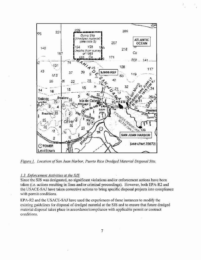
The SJS is an approximately 1 square nautical mile area located approximately 22 nautical miles north-northwest of the entrance to San Juan Harbor positioned in a rectangle bounded by the following coordinates
Degrees Minutes Seconds Degrees Minutes (decimal)
18deg 30 10 N 66deg 09 31 W 18deg 3017 N 66deg 0952 W
18deg 10 N 66deg 08 29 W 18deg 3017 N 66deg 0848 W
18deg 10 N 66deg 08 29 W 18deg 3117 N 66deg 0848 W
18deg 31 10 N 66deg 09 31 W 18deg 3117 N 66deg 0952 W
bull11111114bull1114nalli
Dump Sife I
(dredged ma tetiai) I ATLANTIC(see nore OCEANI 1158 1 tb14-8
)eprhs1 from survey[ 187Of 1983
it 171-lizggmania 202 _141 -131 61
1 45 40 37 39 0 SJHO6-REF
S Lp 42 247-i
C 3--1- c3c4 1 iii 2 1 32pro 34
9 tst~ - ste r 1Ra N-1 i 4ks 2613ttoTi----)-iuri 24 fl R ig i
1 0 - - shy2I- -
Breakeit
SAN JUAN HARBOR
(use chart 25670)6 TOWER
Levittown
Figure 1 Location of San Juan Harbor Puerto Rico Dredged Material Disposal Site
13 Enforcement Activities at the SJS Since the SJS was designated no significant violations andor enforcement actions have been taken (ie actions resulting in fines andor criminal proceedings) However both EPA-R2 and the USACE-SAJ have taken corrective actions to bring specific disposal projects into compliance with permit conditions
EPA-R2 and the USACE-SAJ have used the experiences of these instances to modify the existing guidelines for disposal of dredged material at the SJS and to ensure that future dredged material disposal takes place in accordancecompliance with applicable permit or contract conditions
7
14 Transportation and Disposal Methods Used at the SJS Dredged material disposed at the SJS may be removed from project areas using hopper clamshell or other types of dredges Dredged material has been placed at Puerto Rico ODMDS (San Juan and Ponce) primarily utilizing split-hull barges Specific instructionsrequirements are contained in the Department of the Army (DA) permits issued by the USACE-SAJ listed as contract specifications in Federal dredging contracts and provided to contractors in placement guidelines associated with each dredging project (see Section 10 of this SMMP)
RegulatoryStatutory Responsibilities Under MPRSA USACE and EPA have been assigned various duties pertaining to ocean disposal site management under MPRSA EPA and USACE share responsibility for MPRSA permitting and ocean disposal site designation and management as briefly summarized below
21 Section 102 of the MPRSA Under Section 102 EPA designates recommended times and locations for material disposed at ocean sites (including dredged material) and develops the environmental criteria used in reviewing permit applications
22 Section 103 of the MPRSA Under Section 103 USACE is assigned regulatory responsibility for transportation and disposal of dredged material subject to EPA review and concurrence that the material meets applicable ocean disposal criteria
Dredged Material Testing Requirements As part of the permitting process applicants are required to testcharacterize all dredged material proposed for disposal at SJS to determine if it meets the ocean disposal criteria (ie is suitable for ocean disposal) Dredged material testing proceduresrequirements (including quality assurance requirements) are contained in the following documents
Ocean Dumping Regulations (40 CFR Part 227 Criteria for the Evaluation of Permit Applications for Ocean Dumping of Materials)
-EPAUSACE 1991 Evaluation of Dredged Material Proposed for Ocean Disposal Testing Manual as amended (otherwise known as the Green Book)
EPA Region 2USACE-NYD 1992 (or most recent revision) Guidance for Performing Tests on Dredged Material proposed for Ocean Disposal (otherwise known as the Regional Testing Manual)
EPA-R2 and USACE-SAJ will prepare a regional implementation manual that provides guidance specific to ocean disposal of dredged material at the SJS and other ocean sites in the Caribbean region Until this guidance manual is prepared and approved however the EPA-R2 USACEshyNYD (1992) nanual (or its most recent) revision will be used to evaluate the suitability of dredged material proposed for disposal at the SJS
8
The suitability of dredged material for ocean disposal must be determined by the USACE-SAJ and concurred with by EPA-R2 in writing prior to each authorization The determination of suitability will be valid for three years from the time of testing unless it is determined that conditions at the dredging site may have changed significantly since that time (eg chemical spills) EPA-R2 may extend the authorization for an additional period without further testing if 1) conditions at the dredging site are deemed to not have changed significantly since the time of testing (reduced levels of testing effort may in fact be required to confirm this) and 2) no unacceptable impacts have occurred or are expected at the dredging and disposal sites
4 Past and Anticipated SJS Use and Quantity of Material Disposed MPRSA 102 (c)(3)(D and E) requires that the SMMP include consideration of the quantity of material to be disposed of at the site and the presence nature and bioavailability of contaminants in the material as well as the anticipated use of the site over the long-term
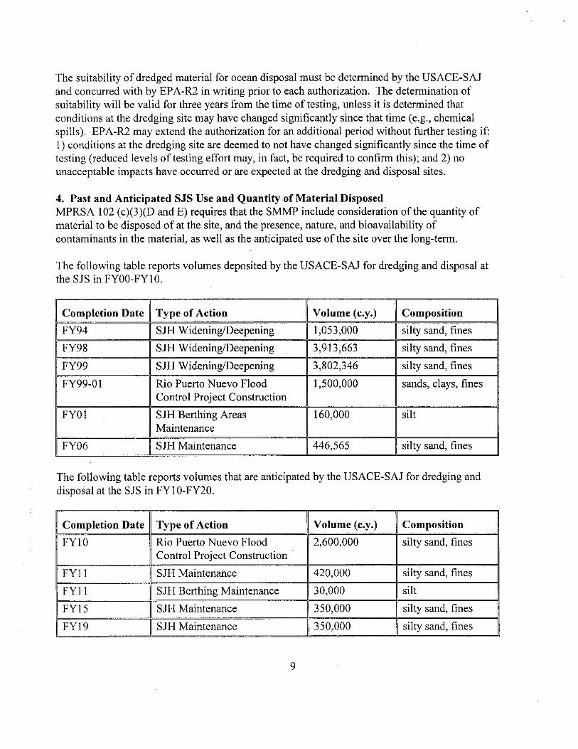
The following table reports volumes deposited by the USACE-SAJ for dredging and disposal at the SJS in FY00-FY10
Completion Date Type of Action Volume (cy) Composition
FY94 SJH WideningDeepening 1053000 silty sand fines
FY98 SJII WideningDeepening 3913663 silty sand fines
FY99 SJH WideningDeepening 3802346 silty sand fines
FY99-01 Rio Puerto Nuevo Flood 1500000 sands clays fines Control Project Construction
FY01 SJH Berthing Areas 160000 silt Maintenance
FY06 SJH Maintenance 446565 silty sand fines
The following table reports volumes that are anticipated by the USACE-SAJ for dredging and disposal at the SJS in FY10-FY20
Completion Date Type of Action Volume (cy) Composition
FY10 Rio Puerto Nuevo Flood 2600000 silty sand fines Control Project Construction
FY11 SJH Maintenance 420000 silty sand fines
FY11 SJH Berthing Maintenance 30000 silt
FY15 SJH Maintenance 350000 silty sand fines
FY19 SJH Maintenance 350000 silty sand fines
9
The only source of material that is expected to be placed at the site during the projected period is dredged material resulting from maintenance of navigable depths in San Juan Harbor and dredged material resulting from construction and maintenance of the Rio Puerto Nuevo Flood Control Project Materials will consist of variable percentages of silt clay and sand There are no proposed limitations on the quantity of material that may be placed at the site
5 Inter-Agency Coordination 51 Transfer of Information EPA-R2 and the USACE-SAJ jointly manage the San Juan Harbor dredged material disposal program and the SJS EPA-R2 and the USACE-SAJ will continue to coordinate the exchange of information management and monitoring resources and the documentation of site management decisions at SJS EPA-R2 and USACE-SAJ will continue to provide each other with all pertinent data and information as it becomes available Specifically upon discoverynotification any information concerning disposaldredging violations will be shared between EPA-R2 and the USACE-SAJ
This SMMP constitutes an official agreement between EPA-R2 and USACE-SAJ to continue to cooperatively manage and monitor the SJS and to coordinate the collection and transfer of information pertinent to the management and monitoring of the SJS as set forth herein
52 Funding of SMMP Tasks and Activities The costs of site management and monitoring will be shared between EPA-R2 and the USACEshySAJ to the extent allowed by funding levels in any given fiscal year (ie cost-sharing will be subject to appropriations)
Consistent with Section 102(c)(3) of the MPRSA the SMMP developed by EPA-R2 in conjunction with the USACE-SAJ shall include a program for monitoring the site that includes the responsible agency(ies) for each monitoring activity The SMMP and as applicable permit conditions will also specify when site users will be required to undertake monitoring activities associated with their projects in accordance with 40 CFR sect 2289 Each Agency will bear its own costs for activities it undertakes in furtherance of the responsibilities established in the SMMP except as provided for in duly executed Interagency Agreements (lAs) pursuant to the Economy Act or the cooperative authority of Section 203 of the MPRSA
The USACE-SAJ will support the monitoring and management of Caribbean Ocean Dredged Material Disposal Sites 1As between EPA-R2 and the USACE-SAJ are encouraged in order to pool resources to implement SMMP activities When appropriate the USACE-SAJ may provide funds to EPA-R2 via an IA for studies of prevailing current conditions transport pathways mapping of coral reef resources and assessments of baseline sediment conditions at or near Caribbean Oct -n Dredge Material Disposal Sites aboard the OSV BOLD (EPAs ocean monitoring vessel) or through contractual mechanisms EPA-R2 has the highly specialized expertise and - socrees to conduct advanced technical work at the Caribbean Ocean Dredged Material Disposal Sites and to complement USACE-SAJ capabilities by providing support in
10
specific areas of expertise in oceanography marine ecology and marine instrumentation that are required for work at the Caribbean Ocean Dredged Material Disposal Sites
These IAs allow the Government to conduct work in the most reasonable and cost effective manner and to realize significant cost savings by using the OSV BOLD (EPAs ocean monitoring vessel) to support the lengthy surveys required for mapping resources and conducting sampling EPA-R2 can also provide such specialized support as side scan SONAR and underwater videography via remote operating vehicle at no additional cost EPA-R2 staff is uniquely capable to oversee the technical merits or limitations of any work products arising from any contractor providing individual site monitoring and management information services through contractual mechanisms
53 Project specific coordination Prior to issue of new permits for private dredging projects Antilles Regulatory Section and EPAshyR2 will discuss special conditions of the permit As monitoring requirements and placement conditions change the special conditions may also be changed to help ensure permit holders conduct dredged material disposal operations at the SJS as safely and efficiently as possible Likewise prior to Federal dredging projects contract specifications are reviewed and updated as necessary to reflect changes in monitoring requirements and placement conditions
6 Objectives of the SMMP The objectives of this SMMP are to collect sufficient information to
provide that no unacceptable environmental impacts occur from the disposal of dredged material at the SJS
recognize and correct any potential unacceptable conditions before they cause any unacceptable impacts to the marine environment or present a navigational hazard to commercial waterborne vessel traffic
determineenforce compliance with MPRSA permit conditions
provide a baseline assessment of conditions at the SJS
outline a program for monitoring the SJS
describe special management conditionspractices to be implemented at the SJS
estimate the quantity of material to be disposed at the SJS considering the presence nature and bioavailability of the contaminants in the dredged material
specify the intended use and possible closure date if necessary of the SJS
i provide a schedule for review and revision of the SJS SMMP
11
7 Site DescriptionAssessment of Baseline Conditions at SJS MPRSA 102 (c)(3)(A) requires that the SMMP include a baseline assessment of conditions at the site Baseline conditions measured by IE Corporation in 1980 were summarized in the Environmental Impact Statement prepared to support designation of the SJS (EPA 1982) Additional baseline biological geological and geochemical data was collected from the SJS in 1984 by JRB Associates (under contract to EPA) In NovemberDecember 1996 EPA-R2 collected sidescan sonar sediment chemistry and benthic community structure data in and around the SJS to augment the baseline assessment of conditions at the SJS The data from the 1996 survey will be incorporated into the baseline assessment as it becomes available Further efforts will be made to enhance our knowledge of baseline conditions during monitoring operations at the SJS
71 Physical Meteorological and Oceanographic Features of the SJS Water depths at the SJS average 292 m (965 ft) Bottom depths at the southern boundary are
approximately 213 m (700 ft) and slope moderately to approximately 400 m (1300 ft) at the northern boundary (EPA 1982)
Easterly trade winds predominate at the SJS throughout the entire year primarily from the ENE direction Wind speeds in the area are moderate The mean annual wind speed is 142 kmhr but shows considerable daily and monthly variation Maximum wind speeds occur in July (mean monthly velocity = 161 kmhr) and minimum wind speeds generally occur in October (11 3 kmhr) Infrequent tropical storms and hurricanes are sometimes severe occur any time from August to October and generally produce considerable rainfall (EPA 1982)
Currents at the SJS are greatly influenced by the direction and strength of the trade winds The trades blow primarily from the northeast which in conjunction with the east-west alignment of the coastline results in a westerly alongshore current Surface currents show general westward drift (mean speed 06 knots) with a significant tidal component Subsurface currents are not well defined but appear to be weak This fact is also evidenced by the relatively undisturbed depositional environment within the SJS and surrounding area
Water column structure at the SJS is more or less uniform throughout the year Salinity and temperature data reveal the existence of a well-mixed layer of surface water The depth of this surface layer varies with season from less than 30 m (April - December) to deeper than 100 m (varies from 100 to 330 ft) The average annual temperature and salinity of this surface water range between 26-28 degC and 355 - 362 ppt Below this surface layer a permanent density gradient (pycnocline) extends to approximately 240 m
e Measurements of baseline dissolved oxygen total suspended solids and turbidity levels in the water column at the SJS were generally within ranges typically associated with unpolluted tropical conditions Surface to bottom dissolved oxygen concentrations range from 54 to73 mgI decreasing with depth below the pycnocline Total suspended solids concentrations
12
measured at the SJS ranged from below detection limits to approximately 18 mgl Turbidity at the SJS ranged from 015 - 059 NTU Suspended solids and turbidity tend to be high in surface waters due to phytoplankton production increase to a localized maximum near the pycnocline and decrease significantly at depth
7 2 Sediment CompositionChemistry and Benthos at the SJS Sedimentary Composition Bottom sediments at the SJS are predominantly fine-grained (ie
silts and clays) with localized sand and gravel areas Samples of bottom sediments taken from the site the SJS average 48 silt and 45 clay Side-scan sonar imaging conducted in 1996 revealed debris and active venting of biogenic gases over limited portions of the site
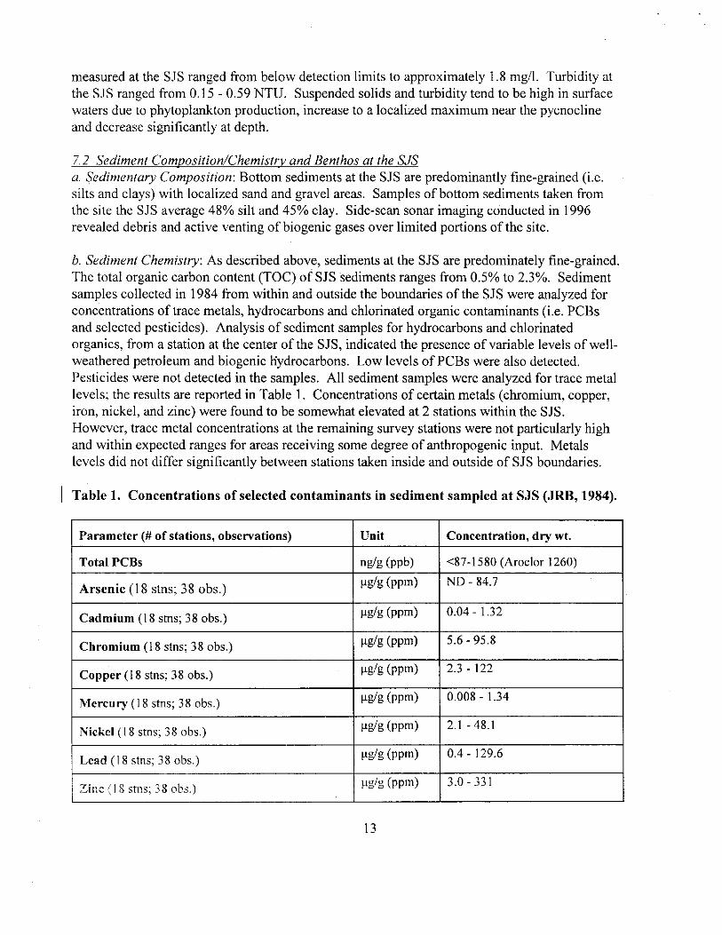
Sediment Chemistry As described above sediments at the SJS are predominately fine-grained The total organic carbon content (TOC) of SJS sediments ranges from 05 to 23 Sediment samples collected in 1984 from within and outside the boundaries of the SJS were analyzed for concentrations of trace metals hydrocarbons and chlorinated organic contaminants (ie PCBs and selected pesticides) Analysis of sediment samples for hydrocarbons and chlorinated organics from a station at the center of the SJS indicated the presence of variable levels of well-weathered petroleum and biogenic hydrocarbons Low levels of PCBs were also detected Pesticides were not detected in the samples All sediment samples were analyzed for trace metal levels the results are reported in Table 1 Concentrations of certain metals (chromium copper iron nickel and zinc) were found to be somewhat elevated at 2 stations within the SJS However trace metal concentrations at the remaining survey stations were not particularly high and within expected ranges for areas receiving some degree of anthropogenic input Metals levels did not differ significantly between stations taken inside and outside of SJS boundaries
Table 1 Concentrations of selected contaminants in sediment sampled at SJS (JRB 1984)
Parameter ( of stations observations) Unit Concentration dry wt
Total PCBs ngg (ppb) lt87-1580 (Aroclor 1260)
ligg (ppm) ND - 847Arsenic (18 stns 38 obs)
pgg (ppm) 004 - 132Cadmium (18 stns 38 obs)
iigg (ppm) 56 - 958Chromium (18 stns 38 obs)
pgg (ppm) 23 - 122Copper (18 stns 38 obs)
[(gig (ppm) 0008 - 134Mercury (18 stns 38 obs)
pgg (ppm) 21 - 481Nickel (18 stns 38 obs)
[(gig (ppm) 04 - 1296Lead (18 stns 38 obs)
pgg (pptn) 30 - 331Zinc (18 stns 38 obs)
13
bull c Benthic Biota Benthic samples taken from the vicinity of the SJS yield low but highly variable numbers of taxa and individuals The benthic community is characteristic of fine-grained bottoms ie the community was dominated by deposit-feeding organisms Numerically dominant taxa in the study area include polychaetes (197 taxa) crustaceans (97 taxa) and molluscs (60 taxa primarily gastropods (snails) and pelecypods (bivalves)) echinoderms (19 taxa) and 25 minor taxa (primarily sipunculids but also including phoronids pogonophorans and cephalochordates) Significant differences in community composition between areas within and outside the SJS have not been detected and the diversity and abundance of organisms are positively correlated with increasing heterogeneity of the bottom sediment
73 Usage of SJS by Fish Marine Mammals and Endangered Species
Marine mammals and sensitive species The SJS does not encompass any known breeding feeding or nursery areas of marine mammals sea turtles or birds Waters off San Juan are regularly visited during the winter months (January-mid-March) by migrating Humpback whales (Megaptera novaeangliae) Humpbacks do not feed while in tropical waters but are often seen spy hopping and engaging in other social display behaviors Newborn calves may accompany female whales since both Silver Bank (off N coast of Hispaniola) and Mona Island (W of Puerto Rico) are known calving grounds for this species Whales can pass within less than 1 mile of shore but are also observed further offshore Dolphins are common residents and may be present in waters of the SJS at any time West Indian manatees have been sighted in shallower coastal waters of Puerto Rico
Four species of sea turtles are also known to inhabit Puerto Rican waters Juvenile green and hawksbill turtles may be found off the northern shore of Puerto Rico associated with rafts of Sargassum Waters of the SJS are too deep to provide foraging habitat for adults of green hawksbill or loggerhead turtles Leatherback marine turtles approach the north shore of Puerto Rico during their nesting season (March-June) and may be present in offshore waters during this time but basically spend the rest of their adult lives in the temperate zone The endangered brown pelican is resident to Puerto Rico but is primarily present inshore
Fish Open waters of SJS may be feeding grounds for pelagic fish (eg tuna jacks mackerel) and deeper site waters may be feeding areas for various snappers and other species but the SJS is not a critical area in this regard Deep waters of the site may be inhabited by various species having wide depth ranges (eg elasmobranchs conger eels batfishes) as well as slope species (eg grenadiers)
A modest but significant commercial pot fishery operates out of San Juan This fishery however is restricted to shallower inshore shelf waters Mackerel sardine snook and snappers constitte the bulk of landings in this fishery A hand line fishery targeting snappers also cperat out of San Juan this fishery operates primarily in shallower water but extends to depths of approximately 600 ft In addition there are numerous private recreational and deep sea charter
14
fishing operations centered at San Juan Effort is generally directed at billfish tuna and other pelagics in this fishery
c Endangered and threatened corals There are two species of corals in Puerto Rican waters listed by NOAA-NMFS under the Endangered Species Act (ESA) as threatened (Acropora palmata and A cervicornis) Acropora sppare important reef building corals typically occurring in high energy shallow water areas NOAA identified critical habitat for Acropora spp as areas having consolidated hardbottom substrates devoid of macroalgae and sediment cover in depths between the Mean High Water line and 30 meters The SJS is located in waters substantially deeper and far removed from areas meeting this depth criterion Critical habitat areas may however be located along the transport routes typically used by barges to travel to and from the SJS
NOAA also identifies a species of deep water coral (Oculina spp) as a species of concern in Puerto Rico The presence of this species however has not been confirmed on the northern coast of Puerto Rico in the vicinity of the SJS In addition NOAA-NMFS is proposing to list additional species of coral as threatened under the ESA Many of these species occur as part of coastal or shelf edge reef habitats (ie depths lt61 m) The SJS is located in waters substantially deeper and far removed from areas meeting this depth criterion (see Shelf Edge Reef Resources (section 74)
74 Shelf Edge Reef Resources Reef resources on the Puerto Rican shelf and along the shelf edge have been identified by the National Oceanic and Atmospheric Administration (NOAA) as essential fish habitat NOAA has indicated that these areas are generally restricted to areas shallower than 200 feet (61 m) Side scan SONAR and remotely operated video mapping showed that coral growth is limited along the coastline east of San Juan Harbor within this depth range Sidescan SONAR and video mapping of areas that are potentially affected by transport and disposal of dredged material at SJS will be implemented as early monitoring efforts in implementation of this revised SMMP before determining any further monitoring or management requirements at the site for protecting shelf edge reef resources
8 SJS Monitoring Program MPRSA 102 (c)(3)(B) requires that the SMMP for a given dredged material ocean disposal site include a program for monitoring the site
EPA-R2USACE-SAJ have developed a tiered monitoring approach to investigate the physical biological and chemical impacts of ocean disposal of dredged material at sites in the Caribbean EPA-R2USACE-SAJs Ocean Disposal Site Monitoring Program (MP) addresses both regulatory and technical issues associated with the disposal of dredged material at the SJS The
15
tiered approach described herein is comprised of levels of increasing investigative intensity designed to generate the technical information necessary to properly manage the disposal site in an environmentally sound and cost-effective manner
Monitoring effort under the SJS MP is dependent upon volume and frequency of disposal In general if no disposal occurs then no monitoring will be required Inversely in a period during which there is disposal activity monitoring would be conducted proportionate to volume of disposal as necessary Specific monitoring activities may also be required for individual projects
81 Goals of the SJS MP The SJS MP will focus on the overall impacts of dredged material on the entire SJS and surrounding area In addition to addressing the Null Hypotheses (Ho) (see Section 82) the overall goals of the SJS SMMP are to
verify that dredged material disposed at the SJS does not cause any unacceptable impacts
assess and monitor (trends) conditions at the SJS as defined in 40 CFR Section 22810 and compare them to baseline data
82 QuestionsNull Hypotheses (Ho) to be addressed by the SJS MP The SJS MP will focus specifically on verifying the following four null hypotheses (Ho) for individual projects andor disposal locations
Hol Dredged material disposal operations are consistent with the requirements of the ocean dumping permits
Actions Use the USACE-approved disposal inspector (ship rider) reports and information submitted by
permittees to determine compliance Require GPS-based automated disposal surveillance systems on all disposal scows at the SJS Conduct independent surveillance of disposal operations
H02 Dredged material disposal operations are not causing unacceptable impacts (physical chemical and biological) at the SJS and surrounding area
Actions -Conduct sediment profile imagery surveys (Tier 2) at the SJS and surrounding area -Conduct benthic community structure sediment chemistry and body burden analyses within the SJS when deemed necessary based on results of Tier 2 physical and biological efforts
16
Ho3 Dredged material disposal has no significant impact on endangered species
Actions Review USACE-approved disposal inspector (ship rider) reports to ensure that no dredged
material disposal occurs in the presence of any marine mammalsendangered turtles Monitor marine mammalssea turtle sightings landings (bycatch) and strandings in the San
Juan vicinity
H04 Dredged material disposal does not significantly alter the benthic community structure of the area of the SJS
Actions Use sediment profile imaging (SPI) photography to assess sediment and benthos distribution
-Conduct Tier 3 benthic community structure monitoring in and around the site
9 Monitoring ActivitiesTechniques 91 WorkQuality Assurance Project Plan The SJS MP consists of a three-tiered approach to monitor the physical chemical and biological effects of dredged material disposed at the SJS the components of these tiers are outlined below in Sections 92 to 94 Information from these monitoring activities will be extremely important for determining the potential for unacceptable impacts to occur due to disposal of dredged material at the SJS For this reason the data obtained in these surveys must be of high quality All monitoring work conducted in accordance with this SMMP must conform to a workquality assurance project plan (WQAPP) that has been reviewed and approved by USACE-SAJ and EPA-R2
Monitoring and sampling will occur using a design that allows quantitative analysis of results the sampling area may include all or part of the SJS the surroundings and a reference area geographically removed from the effect of dredged material disposal at the SJS WQAPPs must reflect the design selected by the Agencies for the monitoring tasks
92 Physical Monitoring Physical monitoring is designed to determine the physical nature and distribution of dredged material during and after disposal at the SJS and environs Measurements of the physical nature of the material proposed for disposal at the SJS will allow first order tracking of physical impacts at the site and support modeling of initial mixing and seafloor deposition following disposal Sediment profile imaging (SPI) will be used to confirm the fate of the material following disposal SPI technology consists of a frame-mounted apparatus that enables a camera to take a picture of the sediment-water interface Useful information can be obtained from the pictures to produce fine scale description of the spread of material on the bottom and its effect on the environment Under certain circumstances the collection and analysis of sediment samples may
17
be required to fully assess the final disposition of dredged material discharged at the SJS
Tier 1 Dredged Material TestingModeling of Disposal EventsDisposal Inspection Grain size distribution percent moisture Atterberg limits and total organic content of proposed materials will be measured for all dredged materials proposed for disposal at the site This data is acquired in support of the evaluation of dredged material proposed for ocean disposal as required by the 1991 Green Book and the regional implementation manual governing disposal at the SJS
Disposals will be modeled using available computer models (eg STFATE) to estimate the footprint and plume anticipated from a proposed project prior to commencement of disposal at the site Results will be used to determine disposal locations at the SJS
GPS-based automated disposal surveillance technology will be used to ascertain that loading and disposal of dredged material is occurring at authorized locations that material is not being lost en route to the site and that material has been discharged within the site boundaries This technology simultaneously records the draft and position of the vessel to which it is attached USACE-approved disposal inspectors (ship riders) will accompany all scows and hopper dredges disposing at the SJS
Frequency Testing and modeling conducted prior to each initial MPRSA concurrence GPS-based automated disposal surveillance to be conducted with each scow load of material transported for disposal at SJS
Tier 2 Sediment profile imagery (SPI) Sediment profile imagery (SPI) cameras will be deployed at an array of stations extending radially outward from the center of the SJS to define the footprint of dredged material within and around the site Sampling locations will be determined jointly by EPA-R2 and USACE-SAJ prior to the surveys Because SPI has not yet been conducted at the site the optimal length and spacing of radial transects will be determined from the first survey From these images grain size sediment color and roughness can be determined and used to identify and map dredged material on the bottom (Images obtained using SPI will also be used in Tier 2 biological evaluation of the site)
Frequency SPI records will be collected approximately every 5 years when the site has been active USACE-SAJ and EPA-R2 will generally conduct these investigations however the agencies may require surveys to be conducted by permittees (or by the USACE-SAJ) following disposal of large volume projects
Note The results of SPI will be used to adjust the Tier 1 model andor disposal operations as necessary
18
Tier 3 Sediment sampling and analysis In cases where additional information is required to refine the final disposition of discharged dredged materials it may be required to actually collect sediment samples from within the SJS and its vicinity for analysis Box core sediment samples will be collected from areas of interest inside andor outside the site Grain size distribution percent moisture and total organic content of sediment samples will be analyzed Tier 3 physical monitoring may be conducted alone or in conjunction with Tier 23 chemical (bulk sediment chemistrybody burden analyses) or Tier 3 biological efforts (benthic community analyses) Samples of the sediment will be collected using appropriate methods to allow for Tier 2 chemical analysis (bulk sediment chemistry) Organisms screened from the sediment will be preserved and archived in a manner that allows Tier 3 biological (benthic community analysis) andor chemical analyses (body burden analysis)
Frequency The need for and the areal extent of Tier 3 physical monitoring efforts will be determined by Tier 2 physical and biological evaluations (ie SPI) In addition Tier 2 monitoring may require confirmationvalidation using box core samples
Note Sediment samples can also be used to assist in the interpretation of SPI imagery through examination of features present in the sample
Special Studies (Physical)
In the event that high resolution of site bathymetry is required a survey using mid-water multibeam sounding equipment would be conducted at the site This type of technology is required for obtaining bathymetry at the SJS because of the great depth of the water However owing to the high cost of this type of surveying and the expectation that accretion of deposited sediments will not result in seafloor features (this expectation is based on the results of monitoring of a deepwater dredged material ocean disposal site off San Francisco CA) it is envisioned that bathymetric surveys of the SJS will not be conducted on a regular basis
In the event that areas that warrant additional concern are identified in the vicinity of the site arrays of sediment traps may be deployed along the margins of the site and in the direction of dredged material transport Sediment traps can determine if significant quantities of dredged material are being transported off the site in the direction of the resource of concern (The traps would have to be deployed for approximately six months of active disposal and would be compared to sedimentation rates at a reference site ie an area that is within the area of influence of hydrographic regimes affecting the SJS but that is unaffected by dredged material disposal) It is not envisioned that sediment traps will need to be deployed on a regular basis
Additional studies and technologies may be used as required to address specific data needs but are not intended for application on a routine basis Examples include sub-bottom profiling and side-scan sonar technologies
Frequency As needed
19
93 Biological Monitoring The review of 96-h exposures of sensitive marine organisms to the suspended and liquid phases and 10-d exposures to the solid phase of dredged material prior to approval for disposal at SJS provides assurances that no acute toxicity is expected to result from disposal of dredged materials at the SJS Determination of long term trends in the benthic community however will require SPI photography or collection and analysis of benthic samples SPI photography provides useful information on the abundances taxa and successional stage of communities present at a given location without the expense of sampling Under certain circumstances actual sampling and analysis of benthic communities in and around the SJS may be required
Tier 1 Review of Testing ResultsMonitoring for Sensitive and Fisheries Species Impacts Toxicity of all project material proposed for ocean disposal will be assessed using sensitive
marine organisms and the procedures outlined in the 1991 Green Book and the regional implementation manual governing disposal at the SJS The results of toxicity tests will be used in conjunction with the STFATE mixing model to ensure that disposal of the project material does not result in violations of the initial mixing requirements following disposal at the SJS By prohibiting materials that show acute toxicity in 10-d tests from disposal at the SJS the first level of assurance that adverse impacts to the benthos or to other marine organisms are not occurring due to the disposal of dredged material is gained The results of bulk sediment and bioaccumulation tests will be used by USACE-SAJ and EPA-R2 to identify and track impacted zones and direct biological sampling efforts at the higher monitoring tiers Impacts to sensitive species (eg marine mammals sea turtles brown pelicans) will be avoided or minimized through the use of on board observers disposal will not be allowed to occur in the presence of identified sensitive species Fisheries issues are re-evaluated for the SJS during each permitauthorization process (Impacts to fisheries due to disposal operations are not anticipated however in the event that issues regarding fisheries are raised to the USACE-SAJ andor EPA-R2 the agencies will consult with resource authorities at NMFS USFWS and the Commonwealth of Puerto Rico to review the issues in the context of dredged material disposal at the SJS)
Frequency Testing and Essential Fish Habitat consultations will be conducted prior to each initial project 103 concurrence On board disposal inspectors will accompany each load of material transported for disposal at SJS
Tier 2 Sediment profile imagery (SRI) SPI cameras will be used to identify and describe colonization and succession status of communities inside and outside site (SPI also serves as Tier 2 physical monitoring) If based on comparisons with a reference site areas outside the site appear to be biologically impacted by disposal activities then the areal extent of impact will be considered in the decision to pursue higher tier testing involving box core sampling (Tier 2 Chemical Tier 3 Physical Chemical Biological) and may result in conditions placed on permits or contract specifications
Frequeric7 SPI rear is will be collected approximately evcy 5 years when the site has been active or if modeling predicts exceedance of site boundary USACE-SAJ and EPA-R2 will
20
generally conduct these investigations however the agencies may require surveys to be conducted by permittees (or by the USACE-SAJ) following disposal of large volume projects
c Tier 3 Benthic sampling and analysis Tier 3 biological monitoring entails counting and identifying benthic organisms collected with box cores to define the status and health of the benthic community (eg species identification diversity biomass trophic status successional stage) Identification of organisms will be to lowest practicable taxonomic unit Sampling of benthos will occur in a stratified random design to allow quantitative analysis of results the sampling area may include all or part of the SJS the surroundings and a reference area geographically removed from the effect of dredged material disposal at SJS
Frequency Impacts within the site are expected due to the disturbances caused by disposal events Impacts outside the site or an absence of progress in the succession or in colonization of the site for extended periods of time after cessation of disposal may be cause for concern and therefore prompt more definitive study in higher tiers of investigation (ie Tier 3 biological Tiers 23 chemical) These indications would be detected using SPI in Tier 2
Note Tier 3 biological monitoring results will also be used to assist in the future interpretation of features present in SPI imagery
d Special Studies (Biological) In the event that concerns regarding local populations of fish or other species (eg crustacean macrofauna or sensitive species) are identified standardized quantitative surveys andor body burden surveys may be required These surveys would use appropriate gear for capturing the target species (eg benthic sleds or trawls) and again use a reference area for comparisons
Frequency As needed
94 Chemical Monitoring Chemical analyses of sediments and tissues of organisms exposed to the material proposed for ocean disposal enables USACE-SAJ and EPA-R2 to assess the presence nature and bioavailability of contaminants in dredged material prior to authorizing disposal at the SJS Periodic collection and analysis of sediment and resident organism tissue samples from the SJS and its environs will provide USACE-SAJ and EPA-R2 with information necessary to confirm that no unacceptable effects are occurring and to identify long term trends in and around the SJS
a Tier 1 Review of ocean disposal testing results Bulk sediment chemistry (and a measure of its bioavailability through biological tests) of proposed dredged material will be determined using the procedures outlined in the 1991 Green Book and the regional implementation manual governing disposal at the SJS prior to commencement of any disposal of the material at the site
21
GPS-based technology will be used to ascertain that loading and disposal of dredged material is occurring at the authorized locations and that material is not being lost en route to the site Visual inspectors will also be deployed
Frequency Conducted with every project
Tier 2 Bulk sediment chemical analysis Bulk sediment chemistry will be conducted on surface samples collected from the SJS and its environs This data will be used to help determine the areal extent and distribution of dredged material and specific contaminants Depending on site management data needs the list of contaminants for a given effort may include all contaminants of concern or a few contaminants selected for their usefulness as tracers of dredged material or for their ecological significance All sediment samples collected for bulk chemistry analysis will also be analyzed for grain size and total organic carbon content (Tier 3 Physical Monitoring) Modeling of the theoretical bioaccumulation potential of non-polar organic contaminants will be used to estimate bioavailability and to determine whether there is a potential for bioaccumulation of these contaminants to unacceptable levels and need for body burden analyses
Frequency The need for Tier 2 chemical monitoring will be determined from the results of SPI conducted under Tier 2 biological and physical monitoring Possible triggers include observations that dredged material appears to have spread significantly outside the site or if SPI imagery suggests that colonizationsuccession is not occurring at rates comparable to reference sites It is anticipated that these analyses will be conducted on the order of every 10 years
Tier 3 Analysis of body burdens of contaminants in benthic organisms Conduct tissue chemical analysis of organisms from box core samples collected during Tier 3 PhysicalBiological Monitoring The species selected for body burden analyses will reflect their abundances in collected samples The substrate in which collected organisms were residing will also be sampled and analyzed [Tier 2 chemical analyses (bulk sediment chemistry) and Tier 3 physical analyses (grain sizeTOCpercent moisture)] and tissue lipid levels will be analyzed to the maximum extent practicable Ideally Tier 3 chemical monitoring will also be conducted synoptically with an evaluation of the health of the benthic community (Tier 3 biological monitoring)
Frequency Tier 3 chemical evaluation will be conducted if TBP modeling using Tier 2 (bulk sediment) chemistry results suggests that there is the potential for unacceptable bioaccumulation of contaminants from the dredged material or if sediment levels exceed reference concentrations by an order of magnitude
Note The results of Tier 3 analysis will be used (in conjunction with Tier 2 chemical (bulk sediment chemistry) and Tier 3 physical results (TOC)) to refine the inputs used in future TBP modeline
22
95 Frequency of MonitoringNeed for Higher Tier Investigations Monitoring at Tier 1 will be conducted prior to disposal of each authorized project An anticipated schedule for monitoring is listed in Table 2 however if results indicate the need for further investigations any required monitoring (Tiers 2 and 3) would be initiated Specific circumstances that trigger advancing to higher tiers of monitoring will be decided by EPA-R2 and the USACE-SAJ in consultation with the Commonwealth of Puerto Rico and other stakeholders Existing monitoring data anticipated or proposed disposals (including the type and quantity of anticipated material) and other relevant factors will be considered to determine appropriate monitoring and management preferences The actual frequencies and schedules for all jointly funded monitoring will be by mutual agreement of USACE-SAJ and EPA-R2
96 Monitoring Data Management Processing Evaluation and Interpretation Data collected from SJS surveys are to be processed and analyzed by (or as specified by) the
USACE-SAJ and EPA-R2 (or their respective contractors) These data are used to make management decisions regarding dredged material disposal operations and permit decisions and must therefore be of reliable quality and in a consistent format
EPA-R2 requires data to be in the National Ocean Data Center (NODC) format where appropriate Survey data will be summarized in a report generated by the action agency The report will indicate how the survey related to the SMMP and to previous SJS surveys Reports should be provided within 90 days after completion Exception to the time limit will be possible if outside contracts stipulate a longer period of time The report will provide data interpretations conclusions and recommendations relative to needs and goals of the SMMP
Data collected will be made available to Federal and Commonwealth agencies and other stakeholders as appropriate Reports summarizing data will also be made available
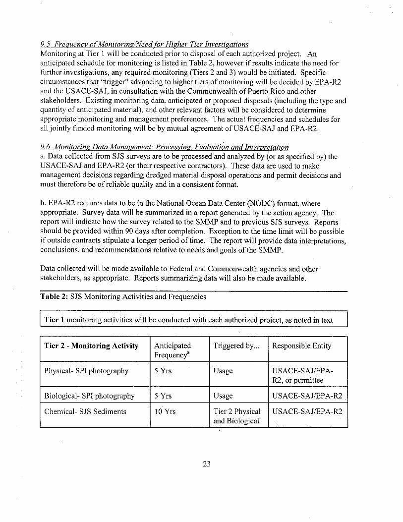
Table 2 SJS Monitoring Activities and Frequencies
Tier 1 monitoring activities will be conducted with each authorized project as noted in text
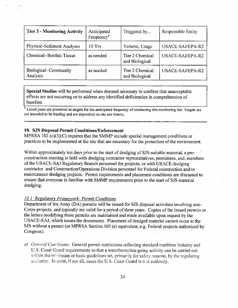
Chemical- Benthic Tissue as needed Tier 2 Chemical and Biological
USACE-SAJEPA-R2
Biological- Community Analysis
as needed Tier 2 Chemical and Biological
USACE-SAJEPA-R2
Special Studies will be performed when deemed necessary to confirm that unacceptable effects are not occurring or to address any identified deficiencies in comprehension of baseline
a Listed years are presented as targets for the anticipated frequency of conducting this monitoring tier Targets are not intended to be binding and are dependent on site use history
10 SJS Disposal Permit ConditionsEnforcement MPRSA 102 (c)(3)(C) requires that the SMMP include special management conditions or practices to be implemented at the site that are necessary for the protection of the environment
Within approximately ten days prior to the start of dredging of SJS-suitable material a preshyconstruction meeting is held with dredging contractor representatives permittees and members of the USACE-SAJ Regulatory Branch personnel for projects or with USACE dredging contractor and ConstructionOperations Division personnel for Federal construction andor maintenance dredging projects Permit requirements and placement conditions are discussed to ensure that everyone is familiar with SMMP requirements prior to the start of SJS-material dredging
101 Regulatory Framework Permit Conditions Department of the Army (DA) permits will be issued for SJS disposal activities involving non-Corps projects and typically are valid for a period of three years Copies of the issued permits or the letters modifying these permits are maintained and made available upon request by the USACE-SAJ which issues the documents Placement of dredged material cannot occur at the SJS without a permit (or MPRSA Section 103 (e) equivalent eg Federal projects authorized by Congress)
a) General Con-qtions General permit restrictions reflecting standard maritime industry and US Coast Guard requirements so that a waterbornesea-going activity can be carried out within the mf nimum or basic guidelines set primarily for safety reasons by the regulating authority In most if not all cases the US Coast Guard is that authority
24
b) SpecialSpecific Conditions Special andor specific permit restrictions will be listed in the text of the permit and will include but not necessarily be limited to
I Seasonal restrictions or special conditions regarding dredging and disposal (assigned on a case by case basis) At present no disposal restrictions related to seasonal variations in ocean current or biotic activity have been determined to be necessary for SJS disposal Should any such restrictions appear necessary as monitoring results are compiled they will be incorporated into future ocean disposal authorizations Additionally if new information indicates that endangered or threatened species are being adversely impacted restrictions will be implemented
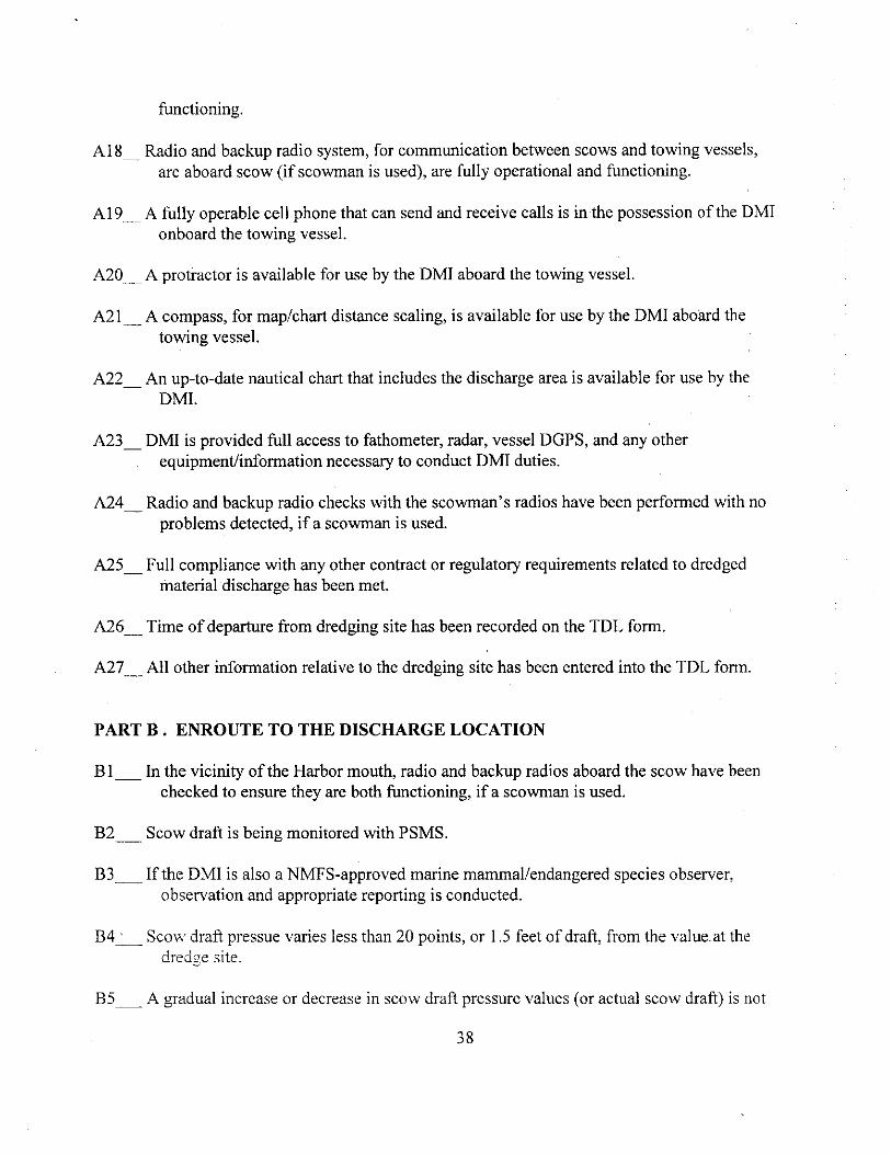
Requirements for the submission of transportation and placement logs USACEshySAJ approved Dredged Material Inspectors (DMIs) are required to document each placement trip on the Transportation and Placement Log Form (Appendix A) and notify the USACE-SAJ The permittee shall hire a DMI independent of the dredge contractor
Reporting requirements for un-anticipated events and discrepancies
4 Guidance pertaining to aspects of the disposal activity including boundary coordinates releasedischarge procedures and requirements to discharge within specific areas The guidance within the permit is also supplemented by the Guidelines provided in Appendix B of this document
102 Federal Authorization In cases where permits are not issued as is the case with Federal Navigation Projects the above permit conditions will be incorporated into dredging contract specifications (see MPRSA Section 103 (e)) When USACE vessels or their contractors conduct the dredging they will comply with the same requirements monitoring and safeguards that are included in permits issued to third party contractors Permit-like instructions specifying all requirements are to be contained within the work specificationsorders for the project These conditions are equivalent to permit conditions and will be enforceable on the contractor under applicable law
103 ViolationEnforcement Cases Disposal at the SJS is to occur only with prior USACE-SAJ approval and EPA-R2
concurrence Projects not in compliance with the DA permit will be subject to enforcement action
A USACE-SAJ approved Dredged Material Inspector (DMI) must accompany all trips for placement of dredged material at the SJS and be present during all dredged material discharge events in order to certify compliance with the USACE-SAJ permit conditions The DMI must report independently to the applicant (not to the dredging contractor) The DMI is required to
25
complete sign submit and maintain within the official record a Transportation and Placement Log Form (Appendix A) for each event
The DMI must also complete sign and submit an Inspector Checklist of requirements associated with each placement trip (Appendix C) The three sections of the Inspector Checklist are completed by the DMI during three phases of transportation and discharge Many checklist items relate to the dredging site Ensuring that all required equipment and procedures are followed prior to departure from the dredging site helps ensure safe and accurate discharge of dredged material at the SJS Any item on the checklist that receives a NO answer meaning that a required procedure has not been followed or required equipment is not present or operable requires an immediate telephone call to USACE-SAJ for follow-up action
If any action takes place which does not conform to authorized activities described in any permit (Contract Specification andor Work Order for Federal Projects) reauthorization response letter or other communicated requirementsrestrictions the USACE-SAJ should be notified immediately by the DMI In cases where activities beyond the scope of those authorized occur appropriate action will be determined by consultation between EPA-R2 and the USACEshySAJ
104 Site InspectionSurveillance To ensure compliance with the DA permit conditions and Federal authorization routine
observations of dredging activities in the San Juan Harbor area are performed by the USACEshySAJ
USACE-SAJ and EPA-R2 (andor their designated representatives) reserve all rights under applicable law to free and unlimited access to andor inspection of
the dredging project site (including the dredge plant towing vessel and scow) at any time during the project
-any equipment used for towing surveying monitoring or navigation
any and all records pertaining to specific (Federal or non-Federal) dredging and disposal projects including logs reports memoranda notes etc
c For all disposal activities the dredging contractor will be required to prepare and operate under an approved electronic verification plan for all disposal operations As part of this plan the contractor will provide an automated system that is operated by an independent (3 rd party) contractor to continuously track the horizontal location and draft condition (vertical) of the disposal vessel from the point of dredging to the disposal area and return to the point of dredging
26
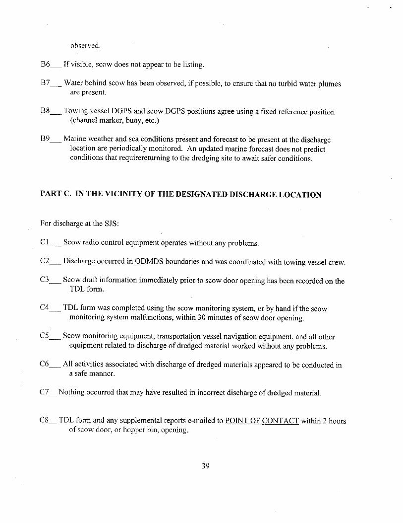
11 Disposal Reporting Requirements and Data Management
111 USCG Reporting Requirements The dredgingtowing contractor must notify the Captain of the Port (COTP) of San JuanUSCG for a reference number before each vessel departs the dredging site for the SJS Every trip made under the permit authorization is required to be recorded and endorsed by the master of the tow or the person acting in such a capacity
112 Record KeepingDocumentationData Reporting Navigation logs will be maintained for each vessel (tugboatbarge) used for ocean disposal of
dredged material These logs should include accuracy calibration methods and any problems and actions taken associated with navigation EPA-R2 and the USACE-SAJ require that each tugboatbarge used for the ocean disposal of dredged material use D-GPS for navigation purposes
An electronic Transportation and Discharge Log form must be completed by the DMI to provide a record of each voyage involving an actual disposal event at the SJS An example of the log form is included in Appendix A The log forms must be emailed to USACE-SAJ and EPAshyR2 within 2 hours of any discharge at the SJS An electronic copy of each log form is to be saved with a filename that includes trip number and retained within a dedicated project folder to allow for auditing of information These notification systems ensure that the USACE-SAJ and EPA-R2 are completely informed of daily dredging and disposal activities undertaken within the Port of San Juan
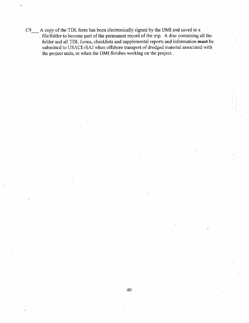
The DM1 must also complete sign and submit an Inspector Checklist of requirements associated with each placement trip (Appendix C) An electronic copy of the checklist for each trip must be retained with the corresponding TDL form in the dedicated project folder to allow for auditing of information The three sections of the Inspector Checklist are completed by the DMI during three phases of transportation and discharge Many checklist items relate to the dredging site Ensuring that all required equipment and procedures are followed prior to departure from the dredging site helps ensure safe and accurate discharge of dredged material at the SJS
GPS-based automated disposal surveillance (ie vessel draft and position) data must be maintained for each vessel used to transport and dispose of dredged material at the SJS Surveillance data is to be submitted to the Agencies on a weekly basis in electronic format Reports should include views of loaded and unloaded paths taken by vessels used for transportation and disposal of dredged material at SJS and the discharge location at SJS This information must be superimposed on a figure that includes the dredging area adjacent shorelines and SJS boundaries) In addition a graphical depiction of draft versus time must be provided with the above information
Discharge locations must be made available for EPA and USACE inspection via a website within
27
12 hours of discharge The website must allow several view sizes to observe the location of discharge Vessel draft readings must be clearly discernible superimposed on a figure that includes the dredging area adjacent shorelines and SJS boundaries
113 Federal SJS Data Management and Reporting A spreadsheet file containing contractor-reported scow volumes information is maintained by the USACE-SAJ All disposal records and submitted monthly disposal volumes for each project are proofread verified and any discrepancies are corrected before entry of data into this spreadsheet On a yearly basis USACE-SAJ will compile all dredging disposal and testing data and submit them to USACE Headquarters
All dredged material disposal data submitted to USACE-SAJ will be compiled analyzed and evaluated in a final end-of-the-year report that will be provided to EPA-R2 during the first quarter of each calendar year andor upon request An annual report will not be necessary if there has been no disposal activity during the previous calendar year
The data file maintained by USACE-SAJ contains information pertaining to the following
PermitFederal Project number
Permittee or Federal Project name
WaterwayReachChannel
Was the project maintenance or improvement
Disposal areabuoy at which the material was releaseddischarged
Coordinates at which the material was releaseddischarged
Disposal activity commencement and completion dates
Volume of material disposed
The year-to-date volumes of private (non-federal) and federal navigation projects disposed at the SJS noted separately and collectively
12 SL1 SMMP Review and Revision MPRS4bdquo 102 (c)(3)(F) requires that the SMMP include a schedule for review and revision of the SMMi hleb shall not be reviewed ay d revised less frequently than 10 years after adoptica of the plan and every 10 years thereafter
28
A need for modification of the use of the SJS because of unacceptable impacts is not anticipated due to the management and monitoring outlined in this SMMP However should the results of monitoring surveys indicate that continuing use of the SJS will lead to unacceptable impacts the SJS SMMP will incorporate further restrictionsrevisions to alleviate the impacts The SMMP will be reviewed annually in conjunction with monitoring data by the interagency SMMP team to identify necessary revisions for management of the SJS
EPA-R2 and the USACE-SAJ will convene a Scientific Review Panel consisting predominantly of professionals from the fields of engineering oceanography and representatives of governmental resource agencies as necessary to review the SJS SMMP and relevant monitoring data Membership will include qualified representatives from academia federal agencies state agencies public interest groups port representatives and consultants Attendance at meetings will be by invitation only
13 References
EPA 1982 Environmental Impact Statement (EIS) for the San Juan Harbor Puerto Rico Dredged Material Disposal Site Designation Prepared by EPA HQ December 1982
EPA-USACE 2000 Site Management and Monitoring Plan for the San Juan Harbor Puerto Rico Dredged Material Disposal Site Final January 5 2000
JRB Associates 1984 Studies and Sample Analyses For San Juan Puerto Rico Dredged Material Disposal Site Report prepared under contract to US Environmental Protection Agency HQ Contract No 68-0106388 Work Assignment 63 September 1984
Battelle Ocean Sciences 1997 Survey Report for Oceanographic Survey of the Five Puerto Rico Dredged Material Ocean Disposal Sites Report prepared under Contract to US Environmental Protection Agency HQ and Region 2 Contract No68-C2-0134 Work Assignment 4-353 May 1997
29
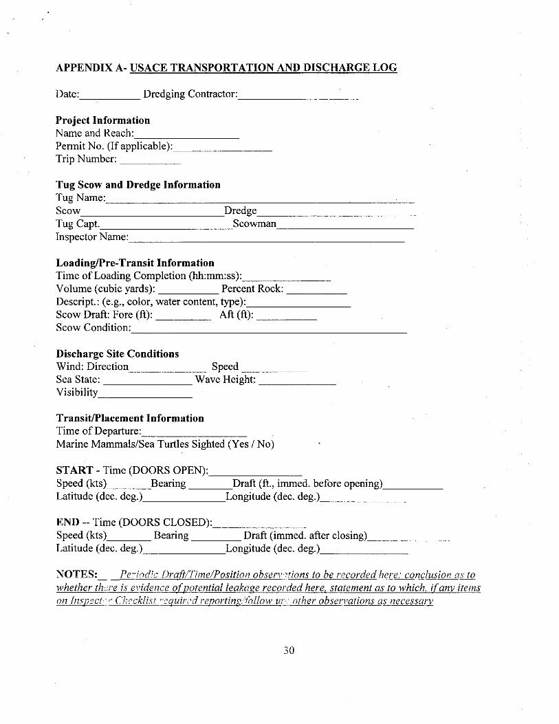
APPENDIX A- USACE TRANSPORTATION AND DISCHARGE LOG
Date Dredging Contractor
Project InformationName and ReachPermit No (If applicable)Trip Number
Tug Scow and Dredge InformationTug NameScow DredgeTug Capt ScowmanInspector Name
LoadingPre-Transit InformationTime of Loading Completion (hhmmss)Volume (cubic yards) Percent RockDescript (eg color water content type)Scow Draft Fore (ft) Aft (ft)Scow Condition
Discharge Site ConditionsWind Direction SpeedSea State Wave Height Visibility
TransitPlacement InformationTime of DepartureMarine MammalsSea Turtles Sighted (Yes No)
START - Time (DOORS OPEN)Speed (kts) Bearing Draft (ft immed before opening)Latitude (dec deg) Longitude (dec deg)
END -- Time (DOORS CLOSED)Speed (kts) Bearing Draft (immed after closing)Latitude (dec deg) Longitude (dec deg)
NOTES Pe-iodic DraftTimePosition observations to be recorded here conclusion as towhether there is evidence of potential leakage recorded here statement as to which if any itemson Inspect Checklist -equirtd reportingfollow un other observations as necessary
30
APPENDIX B - DISCHARGE GUIDELINES FOR AN SJS DISPOSAL PROJECT
Vessel speeds must not exceed 3 knots during discharge weather and sea conditions permitting
To help ensure proper discharge within the SJS and reduce the need for loaded scows to return to the dredging site the following discharge protocol must be followed
Prior to leaving the dredging site scows must be inspected to ensure correct operation of mechanical features Scows must also be inspected for the presence of any conditions that may cause navigation problems The scow radio-control system (if used on the project) and scow monitoring systems must be inspected for correct operation If any problems with the scow radio-control system or scow monitoring systems are encountered corrections must be made before offshore transport of the scow may proceed However when the primary scow monitoring systems (PSMS) are malfunctioning dredged material may be transported from the dredging site if scow monitoring contractor personnel are onboard or are communicating with the USACE-SAJ approved DMI to fixservice the equipment Alternatively the backup scow monitoring system (BSMS) may be used while problems with the PSMS are being corrected However the BSMS is considered to be emergency backup equipment and may only be used on two consecutive trips offshore The BSMS is not to be used as a long-term backup to the PSMS
Scows must be monitored for possible leaks After leaving the dredging site the DMI should check the PSMS scow draft count values on a periodic basis and record the drafttimeposition observations in the notes section of the transportation and discharge log form (in the notes section) along with a conclusion as to whether there is any evidence of possible leakage If the counts begin to significantly change during transport either leakage of dredge material from the scow may be occurring (counts decreasing) or the scows hull may be taking on water (counts increasing) However depending on the specific location of a leak the opposite trend may occur according to the direction of a list caused by a leak Scows suspected of leaking must be inspected before using the scow again If any leaks are found they must be repaired prior to using the scow again
Scows must be brought to the SJS using the DGPS (Differential Global Positioning System) navigation systems of the tugboat and scow Scow position will be monitored by the PSMS onboard the tugboat Discharge in SJS boundaries will be documented by the DMI using the PSMS while the scow position and draft information are monitored automatically by the PSMS
If the PSMS does not show reliable DGPS coordinates in the vicinity of the SS the tugboat DGPS and BSMS must be used to estimate the scow position durin g discharge Length of towlines must be estimated and the bearing to the
31
scow from the towing vessel course must also be noted at the time of discharge Tow lengths must be less than 200 feet unless oceanweather conditions require longer lines for safe navigation The DMI must record the following information if this option is used
coordinates of the tug at the start and end of discharge estimated length and bearing of tow line (distance from tug stern
to scow bow) 3) estimate of lateral displacement of scow from target longitude
Discharge must only occur at the SJS when reliable GPS coordinates are displayed by navigation systems onboard the towing vessels or scows being used at the SJS
If the PSMS fails after leaving the dredging site the scow must not be used again until a fully operational PSMS is installed If scow monitoring contractor personnel are onboard or communicating by telephone with the DMI to correct problems or the BSMS is functional offshore transport may occur However the BSMS is considered to be emergency backup to the PSMS is not to be routinely used for offshore discharge and may only be used on two consecutive offshore discharge trips
If the PSMS is not functioning properly discharge must occur within the SJS only if the scow and towing vessel are both within the SJS at the time scow doors are opened
If a situation arises that requires emergency dumping of dredged material outside of the SJS all reasonable efforts to dump outside of navigation channels and into areas deeper than 200 feet must be made
i) If radio communication with the scow is lost preventing operation of radio-controlled scows a person must board the scow to either fix the problem or operate the scow Persons must only ride aboard scows certified for passengers by the US Coast Guard Extreme care must be taken when boarding a scow at sea Anyone on a scow must have at least two working radios Voice contact through radio or direct communication must be maintained with the scowman while riding aboard the scow Scow opening must only occur when a direct voice command has been given to the scowman or radio communication with radio-controlled scows is maintained If the radio control system can not be fixed the scow must be towed to the designated discharge location and manually tischarged following steps (d) through (f) If the scows engine can not be operated by the radio-control system and the scow is boarded to attempt to fix the e Sine the sco must be located at the designated discharge position if the scows engine s started Past use of radio-controlled scows revealed that
32
manually starting a scows engine after a failed radio-controlled engine start could cause the scow open command to be completed causing the scow to dump at the location of engine startup Any problems with a radio control system must be fixed prior to subsequent use of the scow
Voice contact through radio or direct communication must be maintained with the scowman (if used) for the duration of trips Scow opening must only occur when a direct voice command has been given to the scowman or in the case of radio-controlled scows direct radio communication with the scow is maintained A backup radio must be onboard all manned scows Hand signals must never be used to direct the scowman regarding scow openingclosing Radio checks with the scowman must be performed prior to departing the dredge site and enroute in the vicinity of the harbor mouth Manned scows must not be transported to the discharge location without at least two working modes of radio communication Radios must have adequate power sources and extra sets of batteries must be kept with any battery operated radios DMIs will note in their logs the status of radio checks made prior to site departure and enroute to the discharge location in the comments section of the log form
Scows containing dredged material must not be towed from the dredging site for ocean discharge unless all of the following items are present and fully operational aboard the towing vessel
Legible copy of the permit or contract specifications as related to scow loading transport and dredged material discharge A legible copy of the Discharge Guidelines and SJS boundary coordinates received at the pre-construction meeting or any additional instructions or guidelines as related to scow loading transport and dredged material discharge PSMS and BSMS including bin level sensor on scow DGPS navigation system aboard tug Radio-control system for scow operation (if scowman is not used) Radio and backup radio system aboard scow (if scowman is used) Fathometer aboard tug a fully operational fax machine must be onboard the towing vessel for use by the SAJ Inspector within 2 hours of each discharge event at the SJS an 8 mdash 12 wide protractor with degrees printed or embossed on the curved surface 4 mdash 8 long dividers for scaling distances off of maps and charts scow loading tables for each scow used to transport dredged material access to the towing vessel DGPS Fathometer and radar fully operable personal cellphones in possession of each DMI at all times with active phone numbers unique to each phone available for placing and receiving calls at all times
33
suitable location for completing paperwork associated with DMI duties Full compliance with any other contract or regulatory requirements related to dredged material discharge
If the PSMS is not functioning properly at the time a scow is ready to be transported from dredging site the BSMS may be used while the PSMS problems are being corrected
Scows containing dredged material must not be towed from the dredging site for ocean discharge unless oceanweather conditions are forecast to allow safe and accurate discharge of dredged material within the SJS
Dredged material must never be discharged anywhere outside of the SJS boundary except in cases of emergency Any discharges at outside the boundaries will be investigated for potential enforcement actions
Scow monitoring equipment discharge guidelines and other aspects of dredged material discharge at the SJS may be changed Notice of any changes will be provided to the dredging contractor for implementation as soon as practicable
Transportation and discharge log (TDL) forms will be completed electronically or by hand within 30 minutes of discharge at the SJS An electronic copy of the TDL form is to be emailed to EPA-R2 and USACE-SAJ within two hours of scows return from SJS Printed copies of TDL forms must be signed by the DMI after completion of each trip and placed in a filefolder for submission to USACE-SAJ after project completion or when the DMI permanently or temporarily discontinues working on the project
Disposal Inspectors who have been approved by USACE-SAJ (DMIs) but have not previously worked on a New York District or USACE-SAJ (ie EPA-R2) dredging project must be accompanied by scow monitoring contractor personnel or by a DMI who has been working on the project during the first two trips the DMI works on the project DMIs who have previously worked on at least one New York District or USACE-SAJ (ie EPA-R2) dredging project but who have not worked on this project must be accompanied by scow monitoring contractor personnel during their first trip serving as a DMI on this project
Possible changes in the discharge guidelines may be provided after dredging begins
11 To help ensure that dredged material is transported and placed at the SJS in accordance with the guidelines described above the attached checklist has been prepared Items in the checklist must be revewed by the DMI at the dred ging site while underway and at the SJS Each item that is pertinent to the trip must be answered with a YES or NO answer along with other information specific to a checklist item Any item on the checklist that receives a NO answer must be reported immejiately to the USACE-SAJ at NAME OF CONTACT and a dredging
34
contractor representative not onboard the towing vessel If the NO answer is related to the scow monitoring systems the scow monitoring contractor must also be notified immediately at NAME OF CONTACT Each discharge trip must use a checklist to be completed by the DMI working aboard the towing vessel Checklists must be signed and dated by the DMI and placed in a file All original signed checklists associated with this project must be submitted to the USACE-SAJ on a weekly basis for the duration of the project Checklists must be hand delivered or mailed to USACE ADDRESS HERE
Original copies of TDL forms for each trip to the SJS signed and dated by the DMI on duty during each trip must be submitted to NAME OF CONTACT at the above address at the completion of the project
Switching of tugs once an ocean discharge trip has begun must not occur Towing of any scow loaded with dredged material must be monitored by the scow monitoring equipmentsoftware and documented by a DMI riding aboard the towing vessel
While underway dredging contractor must adhere to all measures required in Appendix D of this SMMP (ie NMFS Southeast Region Vessel Strike Avoidance Measures and Reporting for Mariners)
Upon arrival at the ODMDS the DMI (dredging inspector) must maintain a watch at all times for marine mammals and sea turtles Discharge of dredged material may not occur when there is a turtle or mammal present at the site discharge must not occur until the sighted animal has left the disposal area Animals may not be harassed in any manner to make them leave the area
Failure to adhere to the specifications discussed in these discharge guidelines may result in revocation of the dredging permit andor a monetary fine
If there are any questions pertaining to the guidance given in this document or additional clarification of procedures is needed please contact Mr Mark Reiss of the EPA at (212) 637shy3799
35
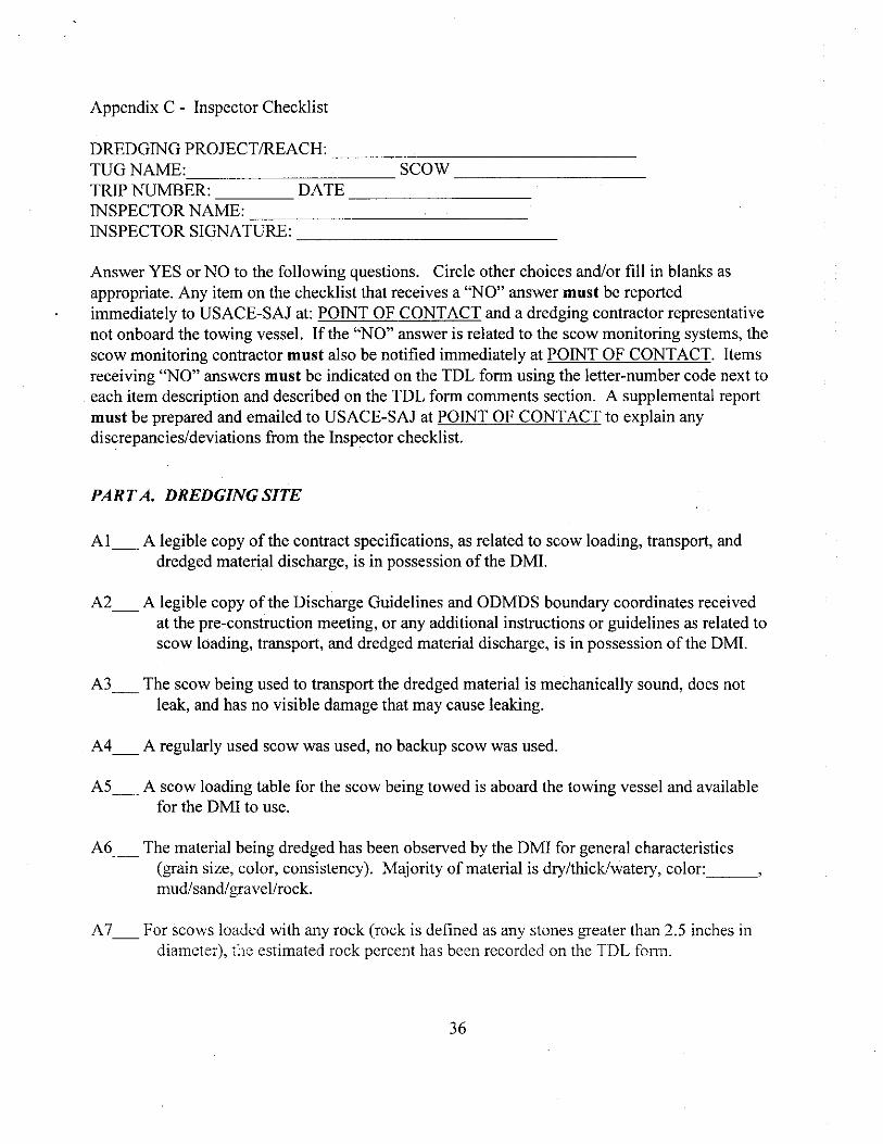
Appendix C - Inspector Checklist
DREDGING PROJECTREACH TUG NAME SCOW TRIP NUMBER DATE INSPECTOR NAME INSPECTOR SIGNATURE
Answer YES or NO to the following questions Circle other choices andor fill in blanks as appropriate Any item on the checklist that receives a NO answer must be reported immediately to USACE-SAJ at POINT OF CONTACT and a dredging contractor representative not onboard the towing vessel If the NO answer is related to the scow monitoring systems the scow monitoring contractor must also be notified immediately at POINT OF CONTACT Items receiving NO answers must be indicated on the TDL form using the letter-number code next to each item description and described on the TDL form comments section A supplemental report must be prepared and emailed to USACE-SAJ at POINT OF CONTACT to explain any discrepanciesdeviations from the Inspector checklist
PART A DREDGING SITE
Al A legible copy of the contract specifications as related to scow loading transport and dredged material discharge is in possession of the DMI
A2 A legible copy of the Discharge Guidelines and ODMDS boundary coordinates received at the pre-construction meeting or any additional instructions or guidelines as related to scow loading transport and dredged material discharge is in possession of the DMI
A3 The scow being used to transport the dredged material is mechanically sound does not leak and has no visible damage that may cause leaking
A4 A regularly used scow was used no backup scow was used
AS A scow loading table for the scow being towed is aboard the towing vessel and available for the DMI to use
A6 The material being dredged has been observed by the DMI for general characteristics (grain size color consistency) Majority of material is drythickwatery color mudsandgravelrock
A7 For scows loaded with any rock (rock is defined as any stones greater than 25 inches in diameter) the estimated rock percent has been recorded on the TDL form
36
AS An estimate of the volume of material in the scow has been calculated by the DMI using the scow loading table and recorded on the TDL form
A9 Scow contains less volume of dredged material than the maximum volume allowed for discharge during a single trip
If a scow contains a volume of dredged material greater than the maximum volume allowed for discharge during a single trip the volume must be decreased below the maximum volume before the dredged material can be transported away from the dredge site
A10 The scow monitoring systems (PSMS and BSMS) are fully operational and are functioning Any scow monitoring system malfunctions must be reported immediately to the scow monitoring contractor POINT OF CONTACT Transportation vessels are not allowed to leave the dredging site with any dredged material if a PSMS is not fully operational However if scow monitoring system contractor personnel are onboard the transporting vessel to service the equipment or in communication with the DMI via cellphone or radio the vessel may depart from the dredging site while malfunctions are being repairedcorrected Alternatively if the BSMS is functional the scow may be transported from the dredging site If the PSMS is not functional the BSMS may only be used on two consecutive offshore discharge trips
Al 1 The scow draft pressure value as displayed by the PSMS system has been recorded on the TDL form
Al2_ A fathometer is fully operational functioning and installed on the transporting vessel
Al3 A radio onboard the transporting vessel is operable and can receive NOAA marine weather forecasts and ocean conditions
A14 Current and forecasted marine weather and ocean conditions at the designated discharge location have been monitored on the radio and will allow safe and accurate discharge of dredged material Winds at a reporting station closest to the discharge location are presently blowing from the with ft seas Winds forecast for the discharge location are from the with seas
Al5 DGPS navigation system is fully operational functioning and installed aboard the transporting vessel
A16 A radar system is fully operational functioning and installed aboard the transporting vessel
Al7 Radio-control system for scow operation (if scowman is not used) is fully operational and
37
functioning
A18 Radio and backup radio system for communication between scows and towing vessels are aboard scow (if scowman is used) are fully operational and functioning
A19 A fully operable cell phone that can send and receive calls is in the possession of the DMI onboard the towing vessel
A20 A protractor is available for use by the DMI aboard the towing vessel
A21 A compass for mapchart distance scaling is available for use by the DMI aboard the towing vessel
A22 An up-to-date nautical chart that includes the discharge area is available for use by the DMI
A23_ DMI is provided full access to fathometer radar vessel DGPS and any other equipmentinformation necessary to conduct DMI duties
A24_ Radio and backup radio checks with the scowmans radios have been performed with no problems detected if a scowman is used
A25_ Full compliance with any other contract or regulatory requirements related to dredged material discharge has been met
A26 Time of departure from dredging site has been recorded on the TDL form
A27_ All other information relative to the dredging site has been entered into the TDL form
PART B ENROUTE TO THE DISCHARGE LOCATION
B1 In the vicinity of the Harbor mouth radio and backup radios aboard the scow have been checked to ensure they are both functioning if a scowman is used
B2 Scow draft is being monitored with PSMS
B3 If the DMI is also a NMFS-approved marine mammalendangered species observer observation and appropriate reporting is conducted
B4 Scow draft pressue varies less than 20 points or 15 feet of draft from the value at the dredge site
B5 A gradual increase or decrease in scow draft pressure values (or actual scow draft) is not
38
observed
B6 If visible scow does not appear to be listing
B7 Water behind scow has been observed if possible to ensure that no turbid water plumes are present
B8 Towing vessel DGPS and scow DGPS positions agree using a fixed reference position (channel marker buoy etc)
B9 Marine weather and sea conditions present and forecast to be present at the discharge location are periodically monitored An updated marine forecast does not predict conditions that requirereturning to the dredging site to await safer conditions
PART C IN THE VICINITY OF THE DESIGNATED DISCHARGE LOCATION
For discharge at the SJS
Cl Scow radio control equipment operates without any problems
C2 Discharge occurred in ODMDS boundaries and was coordinated with towing vessel crew
C3 Scow draft information immediately prior to scow door opening has been recorded on the TDL form
C4 TDL form was completed using the scow monitoring system or by hand if the scow monitoring system malfunctions within 30 minutes of scow door opening
C5 Scow monitoring equipment transportation vessel navigation equipment and all other equipment related to discharge of dredged material worked without any problems
C6 All activities associated with discharge of dredged materials appeared to be conducted in a safe manner
C7 Nothing occurred that may have resulted in incorrect discharge of dredged material
C8 TDL form and any supplemental reports e-mailed to POINT OF CONTACT within 2 hours of scow door or hopper bin opening
39
C9 A copy of the TDL form has been electronically signed by the DMI and saved to a filefolder to become part of the permanent record of the trip A disc containing all the folder and all TDL forms checklists and supplemental reports and information must be submitted to USACE-SAJ when offshore transport of dredged material associated with the project ends or when the DMI finishes working on the project
40
APPENDIX D -Vessel Strike Avoidance Measures and Reporting for Mariners NOAA Fisheries Service Southeast Region (Revised September 2008)
Background The National Marine Fisheries Service (NMFS) has determined that collisions with vessels can injure or kill protected species (eg endangered and threatened species and marine mammals) The following standard measures should be implemented to reduce the risk associated with vessel strikes or disturbance of these protected species to discountable levels NMFS should be contacted to identify any additional conservation and recovery issues of concern and to assist in the development of measures that may be necessary
Protected Species Identification Training Vessel crews should use an Atlantic and Gulf of Mexico reference guide that helps identify protected species that might be encountered in US waters of the Atlantic Ocean including the Caribbean Sea and Gulf of Mexico Additional training should be provided regarding information and resources available regarding federal laws and regulations for protected species ship strike information critical habitat migratory routes and seasonal abundance and recent sightings of protected species
Vessel Strike Avoidance In order to avoid causing injury or death to marine mammals and sea turtles the following measures should be taken when consistent with safe navigation
Vessel operators and crews should maintain a vigilant watch for marine mammals and sea turtles to avoid striking sighted protected species
When whales are sighted maintain a distance of 100 yards or greater between the whale and the vessel
When sea turtles or small cetaceans are sighted attempt to maintain a distance of 50 yards or greater between the animal and the vessel whenever possible
When small cetaceans are sighted while a vessel is underway (eg bow-riding) attempt to remain parallel to the animals course Avoid excessive speed or abrupt changes in direction until the cetacean has left the area
5 Reduce vessel speed to 10 knots or less when mothercalf pairs groups or large assemblages of cetaceans are observed near an underway vessel when safety permits A single cetacean at the surface may indicate the presence of submerged animals in the vicinity therefore prudent precautionary measures should always be exercised The vessel should attempt to route around the animals maintaining a minimum distance of 100 yards whenever possible
41
6 Whales may surface in unpredictable locations or approach slowly moving vessels When an animal is sighted in the vessels path or in close proximity to a moving vessel and when safety permits reduce speed and shift the engine to neutral Do not engage the engines until the animals are clear of the area
Additional Requirements for the North Atlantic Right Whale
If a sighted whale is believed to be a North Atlantic right whale federal regulation requires a minimum distance of 500 yards be maintained from the animal (50 CFR 224103 (c))
Vessels entering North Atlantic right whale critical habitat are required to report into the Mandatory Ship Reporting System
Mariners should check with various communication media for general information regarding avoiding ship strikes and specific information regarding North Atlantic right whale sighting locations These include NOAA weather radio US Coast Guard NAVTEX broadcasts and Notices to Mariners Commercial mariners calling on United States ports should view the most recent version of the NOAAUSCG produced training CD entitled A Prudent Mariners Guide to Right Whale Protection (contact the NMFS Southeast Region Protected Resources Division for more information regarding the CD)
Injured dead or entangled right whales should be immediately reported to the US Coast Guard via VHF Channel 16
Injured or Dead Protected Species Reporting Vessel crews should report sightings of any injured or dead protected species immediately regardless of whether the injury or death is caused by your vessel
Report marine mammals to the Southeast US Stranding Hotline 877-433-8299 Report sea turtles to the NMFS Southeast Regional Office 727-824-5312
If the injury or death of a marine mammal was caused by a collision with your vessel responsible parties should remain available to assist the respective salvage and stranding network as needed NMFS Southeast Regional Office should be immediately notified of the strike by email (takereportnmfsserAnoaagov ) using the attached vessel strike reporting form
For additional information please contact the Protected Resources Division at NOAA Fisheries Service Southeast Regional Office
th
263 13 Avenue South St r_tysburg FL 33701 Tel (727) 824-5312 Visit us on the ws3 at httpseronrifsnoaagov
42
Page 1
Page 2
Page 3
Page 4
Page 5
Page 6
Page 7
Page 8
Page 9
Page 10
Page 11
Page 12
Page 13
Page 14
Page 15
Page 16
Page 17
Page 18
Page 19
Page 20
Page 21
Page 22
Page 23
Page 24
Page 25
Page 26
Page 27
Page 28
Page 29
Page 30
Page 31
Page 32
Page 33
Page 34
Page 35
Page 36
Page 37
Page 38
Page 39
Page 40
Page 41
Page 42
Page 43
Page 44
Table of Contents
Page
List of Acronyms 4
Background 6 11 History of the San Juan Harbor Puerto Rico Dredged Material Disposal Site(SJS) 12 SJS Boundaries 13 Enforcement Activities at the SJS 14 Transportation and Disposal Methods Used at the SJS
RegulatoryStatutory Responsibilities Under MPRSA 8 21 Section 102 of the MPRSA 22 Section 103 of the MPRSA
Dredged Material Testing Requirements 8
Past and Anticipated SJS Use and Quantity of Material Disposed 9
Inter-Agency Coordination 51 Transfer of Information 52 Funding of SMMP Tasks and Activities 53 Project-Specific Coordination
10
Objectives of the SMMP 11
Site DescriptionAssessment of Baseline Conditions at the SJS 71 Physical Meteorological and Oceanographic Features of the SJS 72 Sediment CompositionChemistry and Benthos at the SJS 73 Usage of SJS by Fish Marine Mammals and Endangered Species 74 Shelf Edge Reef Resources
12
SJS Monitoring Program 81 Goals of the SJS Monitoring Program 82 QuestionsNull Hypotheses (Ho) to be Addressed by SJS MP
15
9 Monitoring ActivitiesTechniques 91 WorkQuality Assurance Project Plan n 2 Physical Monitoring 93 Biological Monitoring `4 Chemical Monitoring
= 5 Frequency of MonitoringNeed for Higher Tier Investigations
17
2
96 Monitoring Data Management Processing Evaluation and Interpretation
SJS Disposal Permit ConditionsEnforcement 101 Regulatory Framework Permit Conditions 102 Federal Authorization 103 ViolationEnforcement Cases 104 Site InspectionSurveillance
24
Disposal Reporting Requirements and Data Management 111 USCG Reporting Requirements 112 Record KeepingDocumentationData Reporting 113 Federal SJS Data Management and Reporting
27
SJS SMMP Review and Revision 28
References 29
Appendix A mdash USACE Transportation and Discharge Log 30
Appendix B mdash Discharge Guidelines for an SJS Disposal Project 31
Appendix C mdash Inspector Checklist 36
Appendix D mdash Vessel Strike Avoidance Measures and Reporting for Mariners 41
3
List of Acronyms
COTP mdash Captain of the Port
DA mdash Department of the Army
DMI mdash Dredged Material Inspector in this case approved by USACE-SAJ
EPA- US Environmental Protection Agency
EPA-R2 mdash US Environmental Protection Agency mdash Region 2
IA mdash Interagency Agreement
GPS mdash Global Positioning System
MP mdash Monitoring Plan
MPRSA mdash Marine Protection Research amp Sanctuaries Act of 1972
NMFS mdash National Marine Fisheries Service
NOAA mdash National Oceanic and Atmospheric Administration
NODC mdash National Ocean Data Center
PCBs mdash Polychlorinated biphenyls
ODMDS mdash Ocean Dredged Material Disposal Site
SJH mdash San Juan Harbor
SJS mdash San Juan Puerto Rico Ocean Dredged Material Disposal Site
SMMP mdash Site Management and Monitoring Plan
SPI mdash Sediment Profile Imaging
TOC mdash Total organic carbon
USACE mdash US Army Corps of Engineers
USACE-SAJ mdash US Army Corps of Engineers mdash South Atlantic Jacksonville
USCG mdash United States Coast Guard
USFWS mdash United States Fish amp Wildlife Service
WQAPP mdash WorkQuality Assurance Project Plan
WRDA mdash Water Resources and Development Act
1 Background Section 506 of the Water Resources and Development Act (WRDA) of 1992 which amended the Marine Protection Research and Sanctuaries Act of 1972 (MPRSA) requires the US Environmental Protection Agency (EPA) and the US Army Corps of Engineers (USACE) to prepare a Site Management and Monitoring Plan (SMMP) for each ocean dredged material disposal site (ODMDS) For sites designated prior to January 1 1995 such as the San Juan Harbor Puerto Rico Dredged Material Disposal Site (SJS) WRDA provides that SMMPs shall be developed by January 1 1997 Further permitting or authorization of projects for disposal at ocean sites not having SMMPs after that date were prohibited until an SMMP was prepared The final SMMP for the SJS was adopted on January 5 2000 MPRSA 102 (c)(3)(F) requires that the SMMP be reviewed and revised no less frequently than 10 years after adoption of the plan and every 10 years thereafter
This document revises the WRDA-required SMMP for the final-designated (40 CFR 22815 (d) (11)) San Juan Harbor Puerto Rico Dredged Material Site (SJS) prepared by EPA Region 2 (EPA-R2) and USACE Jacksonville District (USACE-SAJ) This SMMP identifies a number of actions provisions and practices to manage operational aspects of dredging and disposal activities and to perform site monitoring at the SJS
11 History of the San Juan Harbor Puerto Rico Dredged Material Disposal Site Prior to 1974 all dredged material (except for Bar Channel material) taken from San Juan Harbor and its vicinity was placed in upland disposal areas In 1974 these areas were exhausted and no new upland site could be obtained for dredged material disposal Since 1975 all dredged material from San Juan Harbor has been disposed offshore
The SJS was designated as an Interim Ocean Dredged Material Disposal Site in 1977 under MPRSA In March 1988 the SJS was designated as a Final Ocean Dredged Material Disposal Site to receive materials from the San Juan Harbor area
12 SJS Boundaries
The SJS is an approximately 1 square nautical mile area located approximately 22 nautical miles north-northwest of the entrance to San Juan Harbor positioned in a rectangle bounded by the following coordinates
Degrees Minutes Seconds Degrees Minutes (decimal)
18deg 30 10 N 66deg 09 31 W 18deg 3017 N 66deg 0952 W
18deg 10 N 66deg 08 29 W 18deg 3017 N 66deg 0848 W
18deg 10 N 66deg 08 29 W 18deg 3117 N 66deg 0848 W
18deg 31 10 N 66deg 09 31 W 18deg 3117 N 66deg 0952 W
bull11111114bull1114nalli
Dump Sife I
(dredged ma tetiai) I ATLANTIC(see nore OCEANI 1158 1 tb14-8
)eprhs1 from survey[ 187Of 1983
it 171-lizggmania 202 _141 -131 61
1 45 40 37 39 0 SJHO6-REF
S Lp 42 247-i
C 3--1- c3c4 1 iii 2 1 32pro 34
9 tst~ - ste r 1Ra N-1 i 4ks 2613ttoTi----)-iuri 24 fl R ig i
1 0 - - shy2I- -
Breakeit
SAN JUAN HARBOR
(use chart 25670)6 TOWER
Levittown
Figure 1 Location of San Juan Harbor Puerto Rico Dredged Material Disposal Site
13 Enforcement Activities at the SJS Since the SJS was designated no significant violations andor enforcement actions have been taken (ie actions resulting in fines andor criminal proceedings) However both EPA-R2 and the USACE-SAJ have taken corrective actions to bring specific disposal projects into compliance with permit conditions
EPA-R2 and the USACE-SAJ have used the experiences of these instances to modify the existing guidelines for disposal of dredged material at the SJS and to ensure that future dredged material disposal takes place in accordancecompliance with applicable permit or contract conditions
7
14 Transportation and Disposal Methods Used at the SJS Dredged material disposed at the SJS may be removed from project areas using hopper clamshell or other types of dredges Dredged material has been placed at Puerto Rico ODMDS (San Juan and Ponce) primarily utilizing split-hull barges Specific instructionsrequirements are contained in the Department of the Army (DA) permits issued by the USACE-SAJ listed as contract specifications in Federal dredging contracts and provided to contractors in placement guidelines associated with each dredging project (see Section 10 of this SMMP)
RegulatoryStatutory Responsibilities Under MPRSA USACE and EPA have been assigned various duties pertaining to ocean disposal site management under MPRSA EPA and USACE share responsibility for MPRSA permitting and ocean disposal site designation and management as briefly summarized below
21 Section 102 of the MPRSA Under Section 102 EPA designates recommended times and locations for material disposed at ocean sites (including dredged material) and develops the environmental criteria used in reviewing permit applications
22 Section 103 of the MPRSA Under Section 103 USACE is assigned regulatory responsibility for transportation and disposal of dredged material subject to EPA review and concurrence that the material meets applicable ocean disposal criteria
Dredged Material Testing Requirements As part of the permitting process applicants are required to testcharacterize all dredged material proposed for disposal at SJS to determine if it meets the ocean disposal criteria (ie is suitable for ocean disposal) Dredged material testing proceduresrequirements (including quality assurance requirements) are contained in the following documents
Ocean Dumping Regulations (40 CFR Part 227 Criteria for the Evaluation of Permit Applications for Ocean Dumping of Materials)
-EPAUSACE 1991 Evaluation of Dredged Material Proposed for Ocean Disposal Testing Manual as amended (otherwise known as the Green Book)
EPA Region 2USACE-NYD 1992 (or most recent revision) Guidance for Performing Tests on Dredged Material proposed for Ocean Disposal (otherwise known as the Regional Testing Manual)
EPA-R2 and USACE-SAJ will prepare a regional implementation manual that provides guidance specific to ocean disposal of dredged material at the SJS and other ocean sites in the Caribbean region Until this guidance manual is prepared and approved however the EPA-R2 USACEshyNYD (1992) nanual (or its most recent) revision will be used to evaluate the suitability of dredged material proposed for disposal at the SJS
8
The suitability of dredged material for ocean disposal must be determined by the USACE-SAJ and concurred with by EPA-R2 in writing prior to each authorization The determination of suitability will be valid for three years from the time of testing unless it is determined that conditions at the dredging site may have changed significantly since that time (eg chemical spills) EPA-R2 may extend the authorization for an additional period without further testing if 1) conditions at the dredging site are deemed to not have changed significantly since the time of testing (reduced levels of testing effort may in fact be required to confirm this) and 2) no unacceptable impacts have occurred or are expected at the dredging and disposal sites
4 Past and Anticipated SJS Use and Quantity of Material Disposed MPRSA 102 (c)(3)(D and E) requires that the SMMP include consideration of the quantity of material to be disposed of at the site and the presence nature and bioavailability of contaminants in the material as well as the anticipated use of the site over the long-term
The following table reports volumes deposited by the USACE-SAJ for dredging and disposal at the SJS in FY00-FY10
Completion Date Type of Action Volume (cy) Composition
FY94 SJH WideningDeepening 1053000 silty sand fines
FY98 SJII WideningDeepening 3913663 silty sand fines
FY99 SJH WideningDeepening 3802346 silty sand fines
FY99-01 Rio Puerto Nuevo Flood 1500000 sands clays fines Control Project Construction
FY01 SJH Berthing Areas 160000 silt Maintenance
FY06 SJH Maintenance 446565 silty sand fines
The following table reports volumes that are anticipated by the USACE-SAJ for dredging and disposal at the SJS in FY10-FY20
Completion Date Type of Action Volume (cy) Composition
FY10 Rio Puerto Nuevo Flood 2600000 silty sand fines Control Project Construction
FY11 SJH Maintenance 420000 silty sand fines
FY11 SJH Berthing Maintenance 30000 silt
FY15 SJH Maintenance 350000 silty sand fines
FY19 SJH Maintenance 350000 silty sand fines
9
The only source of material that is expected to be placed at the site during the projected period is dredged material resulting from maintenance of navigable depths in San Juan Harbor and dredged material resulting from construction and maintenance of the Rio Puerto Nuevo Flood Control Project Materials will consist of variable percentages of silt clay and sand There are no proposed limitations on the quantity of material that may be placed at the site
5 Inter-Agency Coordination 51 Transfer of Information EPA-R2 and the USACE-SAJ jointly manage the San Juan Harbor dredged material disposal program and the SJS EPA-R2 and the USACE-SAJ will continue to coordinate the exchange of information management and monitoring resources and the documentation of site management decisions at SJS EPA-R2 and USACE-SAJ will continue to provide each other with all pertinent data and information as it becomes available Specifically upon discoverynotification any information concerning disposaldredging violations will be shared between EPA-R2 and the USACE-SAJ
This SMMP constitutes an official agreement between EPA-R2 and USACE-SAJ to continue to cooperatively manage and monitor the SJS and to coordinate the collection and transfer of information pertinent to the management and monitoring of the SJS as set forth herein
52 Funding of SMMP Tasks and Activities The costs of site management and monitoring will be shared between EPA-R2 and the USACEshySAJ to the extent allowed by funding levels in any given fiscal year (ie cost-sharing will be subject to appropriations)
Consistent with Section 102(c)(3) of the MPRSA the SMMP developed by EPA-R2 in conjunction with the USACE-SAJ shall include a program for monitoring the site that includes the responsible agency(ies) for each monitoring activity The SMMP and as applicable permit conditions will also specify when site users will be required to undertake monitoring activities associated with their projects in accordance with 40 CFR sect 2289 Each Agency will bear its own costs for activities it undertakes in furtherance of the responsibilities established in the SMMP except as provided for in duly executed Interagency Agreements (lAs) pursuant to the Economy Act or the cooperative authority of Section 203 of the MPRSA
The USACE-SAJ will support the monitoring and management of Caribbean Ocean Dredged Material Disposal Sites 1As between EPA-R2 and the USACE-SAJ are encouraged in order to pool resources to implement SMMP activities When appropriate the USACE-SAJ may provide funds to EPA-R2 via an IA for studies of prevailing current conditions transport pathways mapping of coral reef resources and assessments of baseline sediment conditions at or near Caribbean Oct -n Dredge Material Disposal Sites aboard the OSV BOLD (EPAs ocean monitoring vessel) or through contractual mechanisms EPA-R2 has the highly specialized expertise and - socrees to conduct advanced technical work at the Caribbean Ocean Dredged Material Disposal Sites and to complement USACE-SAJ capabilities by providing support in
10
specific areas of expertise in oceanography marine ecology and marine instrumentation that are required for work at the Caribbean Ocean Dredged Material Disposal Sites
These IAs allow the Government to conduct work in the most reasonable and cost effective manner and to realize significant cost savings by using the OSV BOLD (EPAs ocean monitoring vessel) to support the lengthy surveys required for mapping resources and conducting sampling EPA-R2 can also provide such specialized support as side scan SONAR and underwater videography via remote operating vehicle at no additional cost EPA-R2 staff is uniquely capable to oversee the technical merits or limitations of any work products arising from any contractor providing individual site monitoring and management information services through contractual mechanisms
53 Project specific coordination Prior to issue of new permits for private dredging projects Antilles Regulatory Section and EPAshyR2 will discuss special conditions of the permit As monitoring requirements and placement conditions change the special conditions may also be changed to help ensure permit holders conduct dredged material disposal operations at the SJS as safely and efficiently as possible Likewise prior to Federal dredging projects contract specifications are reviewed and updated as necessary to reflect changes in monitoring requirements and placement conditions
6 Objectives of the SMMP The objectives of this SMMP are to collect sufficient information to
provide that no unacceptable environmental impacts occur from the disposal of dredged material at the SJS
recognize and correct any potential unacceptable conditions before they cause any unacceptable impacts to the marine environment or present a navigational hazard to commercial waterborne vessel traffic
determineenforce compliance with MPRSA permit conditions
provide a baseline assessment of conditions at the SJS
outline a program for monitoring the SJS
describe special management conditionspractices to be implemented at the SJS
estimate the quantity of material to be disposed at the SJS considering the presence nature and bioavailability of the contaminants in the dredged material
specify the intended use and possible closure date if necessary of the SJS
i provide a schedule for review and revision of the SJS SMMP
11
7 Site DescriptionAssessment of Baseline Conditions at SJS MPRSA 102 (c)(3)(A) requires that the SMMP include a baseline assessment of conditions at the site Baseline conditions measured by IE Corporation in 1980 were summarized in the Environmental Impact Statement prepared to support designation of the SJS (EPA 1982) Additional baseline biological geological and geochemical data was collected from the SJS in 1984 by JRB Associates (under contract to EPA) In NovemberDecember 1996 EPA-R2 collected sidescan sonar sediment chemistry and benthic community structure data in and around the SJS to augment the baseline assessment of conditions at the SJS The data from the 1996 survey will be incorporated into the baseline assessment as it becomes available Further efforts will be made to enhance our knowledge of baseline conditions during monitoring operations at the SJS
71 Physical Meteorological and Oceanographic Features of the SJS Water depths at the SJS average 292 m (965 ft) Bottom depths at the southern boundary are
approximately 213 m (700 ft) and slope moderately to approximately 400 m (1300 ft) at the northern boundary (EPA 1982)
Easterly trade winds predominate at the SJS throughout the entire year primarily from the ENE direction Wind speeds in the area are moderate The mean annual wind speed is 142 kmhr but shows considerable daily and monthly variation Maximum wind speeds occur in July (mean monthly velocity = 161 kmhr) and minimum wind speeds generally occur in October (11 3 kmhr) Infrequent tropical storms and hurricanes are sometimes severe occur any time from August to October and generally produce considerable rainfall (EPA 1982)
Currents at the SJS are greatly influenced by the direction and strength of the trade winds The trades blow primarily from the northeast which in conjunction with the east-west alignment of the coastline results in a westerly alongshore current Surface currents show general westward drift (mean speed 06 knots) with a significant tidal component Subsurface currents are not well defined but appear to be weak This fact is also evidenced by the relatively undisturbed depositional environment within the SJS and surrounding area
Water column structure at the SJS is more or less uniform throughout the year Salinity and temperature data reveal the existence of a well-mixed layer of surface water The depth of this surface layer varies with season from less than 30 m (April - December) to deeper than 100 m (varies from 100 to 330 ft) The average annual temperature and salinity of this surface water range between 26-28 degC and 355 - 362 ppt Below this surface layer a permanent density gradient (pycnocline) extends to approximately 240 m
e Measurements of baseline dissolved oxygen total suspended solids and turbidity levels in the water column at the SJS were generally within ranges typically associated with unpolluted tropical conditions Surface to bottom dissolved oxygen concentrations range from 54 to73 mgI decreasing with depth below the pycnocline Total suspended solids concentrations
12
measured at the SJS ranged from below detection limits to approximately 18 mgl Turbidity at the SJS ranged from 015 - 059 NTU Suspended solids and turbidity tend to be high in surface waters due to phytoplankton production increase to a localized maximum near the pycnocline and decrease significantly at depth
7 2 Sediment CompositionChemistry and Benthos at the SJS Sedimentary Composition Bottom sediments at the SJS are predominantly fine-grained (ie
silts and clays) with localized sand and gravel areas Samples of bottom sediments taken from the site the SJS average 48 silt and 45 clay Side-scan sonar imaging conducted in 1996 revealed debris and active venting of biogenic gases over limited portions of the site
Sediment Chemistry As described above sediments at the SJS are predominately fine-grained The total organic carbon content (TOC) of SJS sediments ranges from 05 to 23 Sediment samples collected in 1984 from within and outside the boundaries of the SJS were analyzed for concentrations of trace metals hydrocarbons and chlorinated organic contaminants (ie PCBs and selected pesticides) Analysis of sediment samples for hydrocarbons and chlorinated organics from a station at the center of the SJS indicated the presence of variable levels of well-weathered petroleum and biogenic hydrocarbons Low levels of PCBs were also detected Pesticides were not detected in the samples All sediment samples were analyzed for trace metal levels the results are reported in Table 1 Concentrations of certain metals (chromium copper iron nickel and zinc) were found to be somewhat elevated at 2 stations within the SJS However trace metal concentrations at the remaining survey stations were not particularly high and within expected ranges for areas receiving some degree of anthropogenic input Metals levels did not differ significantly between stations taken inside and outside of SJS boundaries
Table 1 Concentrations of selected contaminants in sediment sampled at SJS (JRB 1984)
Parameter ( of stations observations) Unit Concentration dry wt
Total PCBs ngg (ppb) lt87-1580 (Aroclor 1260)
ligg (ppm) ND - 847Arsenic (18 stns 38 obs)
pgg (ppm) 004 - 132Cadmium (18 stns 38 obs)
iigg (ppm) 56 - 958Chromium (18 stns 38 obs)
pgg (ppm) 23 - 122Copper (18 stns 38 obs)
[(gig (ppm) 0008 - 134Mercury (18 stns 38 obs)
pgg (ppm) 21 - 481Nickel (18 stns 38 obs)
[(gig (ppm) 04 - 1296Lead (18 stns 38 obs)
pgg (pptn) 30 - 331Zinc (18 stns 38 obs)
13
bull c Benthic Biota Benthic samples taken from the vicinity of the SJS yield low but highly variable numbers of taxa and individuals The benthic community is characteristic of fine-grained bottoms ie the community was dominated by deposit-feeding organisms Numerically dominant taxa in the study area include polychaetes (197 taxa) crustaceans (97 taxa) and molluscs (60 taxa primarily gastropods (snails) and pelecypods (bivalves)) echinoderms (19 taxa) and 25 minor taxa (primarily sipunculids but also including phoronids pogonophorans and cephalochordates) Significant differences in community composition between areas within and outside the SJS have not been detected and the diversity and abundance of organisms are positively correlated with increasing heterogeneity of the bottom sediment
73 Usage of SJS by Fish Marine Mammals and Endangered Species
Marine mammals and sensitive species The SJS does not encompass any known breeding feeding or nursery areas of marine mammals sea turtles or birds Waters off San Juan are regularly visited during the winter months (January-mid-March) by migrating Humpback whales (Megaptera novaeangliae) Humpbacks do not feed while in tropical waters but are often seen spy hopping and engaging in other social display behaviors Newborn calves may accompany female whales since both Silver Bank (off N coast of Hispaniola) and Mona Island (W of Puerto Rico) are known calving grounds for this species Whales can pass within less than 1 mile of shore but are also observed further offshore Dolphins are common residents and may be present in waters of the SJS at any time West Indian manatees have been sighted in shallower coastal waters of Puerto Rico
Four species of sea turtles are also known to inhabit Puerto Rican waters Juvenile green and hawksbill turtles may be found off the northern shore of Puerto Rico associated with rafts of Sargassum Waters of the SJS are too deep to provide foraging habitat for adults of green hawksbill or loggerhead turtles Leatherback marine turtles approach the north shore of Puerto Rico during their nesting season (March-June) and may be present in offshore waters during this time but basically spend the rest of their adult lives in the temperate zone The endangered brown pelican is resident to Puerto Rico but is primarily present inshore
Fish Open waters of SJS may be feeding grounds for pelagic fish (eg tuna jacks mackerel) and deeper site waters may be feeding areas for various snappers and other species but the SJS is not a critical area in this regard Deep waters of the site may be inhabited by various species having wide depth ranges (eg elasmobranchs conger eels batfishes) as well as slope species (eg grenadiers)
A modest but significant commercial pot fishery operates out of San Juan This fishery however is restricted to shallower inshore shelf waters Mackerel sardine snook and snappers constitte the bulk of landings in this fishery A hand line fishery targeting snappers also cperat out of San Juan this fishery operates primarily in shallower water but extends to depths of approximately 600 ft In addition there are numerous private recreational and deep sea charter
14
fishing operations centered at San Juan Effort is generally directed at billfish tuna and other pelagics in this fishery
c Endangered and threatened corals There are two species of corals in Puerto Rican waters listed by NOAA-NMFS under the Endangered Species Act (ESA) as threatened (Acropora palmata and A cervicornis) Acropora sppare important reef building corals typically occurring in high energy shallow water areas NOAA identified critical habitat for Acropora spp as areas having consolidated hardbottom substrates devoid of macroalgae and sediment cover in depths between the Mean High Water line and 30 meters The SJS is located in waters substantially deeper and far removed from areas meeting this depth criterion Critical habitat areas may however be located along the transport routes typically used by barges to travel to and from the SJS
NOAA also identifies a species of deep water coral (Oculina spp) as a species of concern in Puerto Rico The presence of this species however has not been confirmed on the northern coast of Puerto Rico in the vicinity of the SJS In addition NOAA-NMFS is proposing to list additional species of coral as threatened under the ESA Many of these species occur as part of coastal or shelf edge reef habitats (ie depths lt61 m) The SJS is located in waters substantially deeper and far removed from areas meeting this depth criterion (see Shelf Edge Reef Resources (section 74)
74 Shelf Edge Reef Resources Reef resources on the Puerto Rican shelf and along the shelf edge have been identified by the National Oceanic and Atmospheric Administration (NOAA) as essential fish habitat NOAA has indicated that these areas are generally restricted to areas shallower than 200 feet (61 m) Side scan SONAR and remotely operated video mapping showed that coral growth is limited along the coastline east of San Juan Harbor within this depth range Sidescan SONAR and video mapping of areas that are potentially affected by transport and disposal of dredged material at SJS will be implemented as early monitoring efforts in implementation of this revised SMMP before determining any further monitoring or management requirements at the site for protecting shelf edge reef resources
8 SJS Monitoring Program MPRSA 102 (c)(3)(B) requires that the SMMP for a given dredged material ocean disposal site include a program for monitoring the site
EPA-R2USACE-SAJ have developed a tiered monitoring approach to investigate the physical biological and chemical impacts of ocean disposal of dredged material at sites in the Caribbean EPA-R2USACE-SAJs Ocean Disposal Site Monitoring Program (MP) addresses both regulatory and technical issues associated with the disposal of dredged material at the SJS The
15
tiered approach described herein is comprised of levels of increasing investigative intensity designed to generate the technical information necessary to properly manage the disposal site in an environmentally sound and cost-effective manner
Monitoring effort under the SJS MP is dependent upon volume and frequency of disposal In general if no disposal occurs then no monitoring will be required Inversely in a period during which there is disposal activity monitoring would be conducted proportionate to volume of disposal as necessary Specific monitoring activities may also be required for individual projects
81 Goals of the SJS MP The SJS MP will focus on the overall impacts of dredged material on the entire SJS and surrounding area In addition to addressing the Null Hypotheses (Ho) (see Section 82) the overall goals of the SJS SMMP are to
verify that dredged material disposed at the SJS does not cause any unacceptable impacts
assess and monitor (trends) conditions at the SJS as defined in 40 CFR Section 22810 and compare them to baseline data
82 QuestionsNull Hypotheses (Ho) to be addressed by the SJS MP The SJS MP will focus specifically on verifying the following four null hypotheses (Ho) for individual projects andor disposal locations
Hol Dredged material disposal operations are consistent with the requirements of the ocean dumping permits
Actions Use the USACE-approved disposal inspector (ship rider) reports and information submitted by
permittees to determine compliance Require GPS-based automated disposal surveillance systems on all disposal scows at the SJS Conduct independent surveillance of disposal operations
H02 Dredged material disposal operations are not causing unacceptable impacts (physical chemical and biological) at the SJS and surrounding area
Actions -Conduct sediment profile imagery surveys (Tier 2) at the SJS and surrounding area -Conduct benthic community structure sediment chemistry and body burden analyses within the SJS when deemed necessary based on results of Tier 2 physical and biological efforts
16
Ho3 Dredged material disposal has no significant impact on endangered species
Actions Review USACE-approved disposal inspector (ship rider) reports to ensure that no dredged
material disposal occurs in the presence of any marine mammalsendangered turtles Monitor marine mammalssea turtle sightings landings (bycatch) and strandings in the San
Juan vicinity
H04 Dredged material disposal does not significantly alter the benthic community structure of the area of the SJS
Actions Use sediment profile imaging (SPI) photography to assess sediment and benthos distribution
-Conduct Tier 3 benthic community structure monitoring in and around the site
9 Monitoring ActivitiesTechniques 91 WorkQuality Assurance Project Plan The SJS MP consists of a three-tiered approach to monitor the physical chemical and biological effects of dredged material disposed at the SJS the components of these tiers are outlined below in Sections 92 to 94 Information from these monitoring activities will be extremely important for determining the potential for unacceptable impacts to occur due to disposal of dredged material at the SJS For this reason the data obtained in these surveys must be of high quality All monitoring work conducted in accordance with this SMMP must conform to a workquality assurance project plan (WQAPP) that has been reviewed and approved by USACE-SAJ and EPA-R2
Monitoring and sampling will occur using a design that allows quantitative analysis of results the sampling area may include all or part of the SJS the surroundings and a reference area geographically removed from the effect of dredged material disposal at the SJS WQAPPs must reflect the design selected by the Agencies for the monitoring tasks
92 Physical Monitoring Physical monitoring is designed to determine the physical nature and distribution of dredged material during and after disposal at the SJS and environs Measurements of the physical nature of the material proposed for disposal at the SJS will allow first order tracking of physical impacts at the site and support modeling of initial mixing and seafloor deposition following disposal Sediment profile imaging (SPI) will be used to confirm the fate of the material following disposal SPI technology consists of a frame-mounted apparatus that enables a camera to take a picture of the sediment-water interface Useful information can be obtained from the pictures to produce fine scale description of the spread of material on the bottom and its effect on the environment Under certain circumstances the collection and analysis of sediment samples may
17
be required to fully assess the final disposition of dredged material discharged at the SJS
Tier 1 Dredged Material TestingModeling of Disposal EventsDisposal Inspection Grain size distribution percent moisture Atterberg limits and total organic content of proposed materials will be measured for all dredged materials proposed for disposal at the site This data is acquired in support of the evaluation of dredged material proposed for ocean disposal as required by the 1991 Green Book and the regional implementation manual governing disposal at the SJS
Disposals will be modeled using available computer models (eg STFATE) to estimate the footprint and plume anticipated from a proposed project prior to commencement of disposal at the site Results will be used to determine disposal locations at the SJS
GPS-based automated disposal surveillance technology will be used to ascertain that loading and disposal of dredged material is occurring at authorized locations that material is not being lost en route to the site and that material has been discharged within the site boundaries This technology simultaneously records the draft and position of the vessel to which it is attached USACE-approved disposal inspectors (ship riders) will accompany all scows and hopper dredges disposing at the SJS
Frequency Testing and modeling conducted prior to each initial MPRSA concurrence GPS-based automated disposal surveillance to be conducted with each scow load of material transported for disposal at SJS
Tier 2 Sediment profile imagery (SPI) Sediment profile imagery (SPI) cameras will be deployed at an array of stations extending radially outward from the center of the SJS to define the footprint of dredged material within and around the site Sampling locations will be determined jointly by EPA-R2 and USACE-SAJ prior to the surveys Because SPI has not yet been conducted at the site the optimal length and spacing of radial transects will be determined from the first survey From these images grain size sediment color and roughness can be determined and used to identify and map dredged material on the bottom (Images obtained using SPI will also be used in Tier 2 biological evaluation of the site)
Frequency SPI records will be collected approximately every 5 years when the site has been active USACE-SAJ and EPA-R2 will generally conduct these investigations however the agencies may require surveys to be conducted by permittees (or by the USACE-SAJ) following disposal of large volume projects
Note The results of SPI will be used to adjust the Tier 1 model andor disposal operations as necessary
18
Tier 3 Sediment sampling and analysis In cases where additional information is required to refine the final disposition of discharged dredged materials it may be required to actually collect sediment samples from within the SJS and its vicinity for analysis Box core sediment samples will be collected from areas of interest inside andor outside the site Grain size distribution percent moisture and total organic content of sediment samples will be analyzed Tier 3 physical monitoring may be conducted alone or in conjunction with Tier 23 chemical (bulk sediment chemistrybody burden analyses) or Tier 3 biological efforts (benthic community analyses) Samples of the sediment will be collected using appropriate methods to allow for Tier 2 chemical analysis (bulk sediment chemistry) Organisms screened from the sediment will be preserved and archived in a manner that allows Tier 3 biological (benthic community analysis) andor chemical analyses (body burden analysis)
Frequency The need for and the areal extent of Tier 3 physical monitoring efforts will be determined by Tier 2 physical and biological evaluations (ie SPI) In addition Tier 2 monitoring may require confirmationvalidation using box core samples
Note Sediment samples can also be used to assist in the interpretation of SPI imagery through examination of features present in the sample
Special Studies (Physical)
In the event that high resolution of site bathymetry is required a survey using mid-water multibeam sounding equipment would be conducted at the site This type of technology is required for obtaining bathymetry at the SJS because of the great depth of the water However owing to the high cost of this type of surveying and the expectation that accretion of deposited sediments will not result in seafloor features (this expectation is based on the results of monitoring of a deepwater dredged material ocean disposal site off San Francisco CA) it is envisioned that bathymetric surveys of the SJS will not be conducted on a regular basis
In the event that areas that warrant additional concern are identified in the vicinity of the site arrays of sediment traps may be deployed along the margins of the site and in the direction of dredged material transport Sediment traps can determine if significant quantities of dredged material are being transported off the site in the direction of the resource of concern (The traps would have to be deployed for approximately six months of active disposal and would be compared to sedimentation rates at a reference site ie an area that is within the area of influence of hydrographic regimes affecting the SJS but that is unaffected by dredged material disposal) It is not envisioned that sediment traps will need to be deployed on a regular basis
Additional studies and technologies may be used as required to address specific data needs but are not intended for application on a routine basis Examples include sub-bottom profiling and side-scan sonar technologies
Frequency As needed
19
93 Biological Monitoring The review of 96-h exposures of sensitive marine organisms to the suspended and liquid phases and 10-d exposures to the solid phase of dredged material prior to approval for disposal at SJS provides assurances that no acute toxicity is expected to result from disposal of dredged materials at the SJS Determination of long term trends in the benthic community however will require SPI photography or collection and analysis of benthic samples SPI photography provides useful information on the abundances taxa and successional stage of communities present at a given location without the expense of sampling Under certain circumstances actual sampling and analysis of benthic communities in and around the SJS may be required
Tier 1 Review of Testing ResultsMonitoring for Sensitive and Fisheries Species Impacts Toxicity of all project material proposed for ocean disposal will be assessed using sensitive
marine organisms and the procedures outlined in the 1991 Green Book and the regional implementation manual governing disposal at the SJS The results of toxicity tests will be used in conjunction with the STFATE mixing model to ensure that disposal of the project material does not result in violations of the initial mixing requirements following disposal at the SJS By prohibiting materials that show acute toxicity in 10-d tests from disposal at the SJS the first level of assurance that adverse impacts to the benthos or to other marine organisms are not occurring due to the disposal of dredged material is gained The results of bulk sediment and bioaccumulation tests will be used by USACE-SAJ and EPA-R2 to identify and track impacted zones and direct biological sampling efforts at the higher monitoring tiers Impacts to sensitive species (eg marine mammals sea turtles brown pelicans) will be avoided or minimized through the use of on board observers disposal will not be allowed to occur in the presence of identified sensitive species Fisheries issues are re-evaluated for the SJS during each permitauthorization process (Impacts to fisheries due to disposal operations are not anticipated however in the event that issues regarding fisheries are raised to the USACE-SAJ andor EPA-R2 the agencies will consult with resource authorities at NMFS USFWS and the Commonwealth of Puerto Rico to review the issues in the context of dredged material disposal at the SJS)
Frequency Testing and Essential Fish Habitat consultations will be conducted prior to each initial project 103 concurrence On board disposal inspectors will accompany each load of material transported for disposal at SJS
Tier 2 Sediment profile imagery (SRI) SPI cameras will be used to identify and describe colonization and succession status of communities inside and outside site (SPI also serves as Tier 2 physical monitoring) If based on comparisons with a reference site areas outside the site appear to be biologically impacted by disposal activities then the areal extent of impact will be considered in the decision to pursue higher tier testing involving box core sampling (Tier 2 Chemical Tier 3 Physical Chemical Biological) and may result in conditions placed on permits or contract specifications
Frequeric7 SPI rear is will be collected approximately evcy 5 years when the site has been active or if modeling predicts exceedance of site boundary USACE-SAJ and EPA-R2 will
20
generally conduct these investigations however the agencies may require surveys to be conducted by permittees (or by the USACE-SAJ) following disposal of large volume projects
c Tier 3 Benthic sampling and analysis Tier 3 biological monitoring entails counting and identifying benthic organisms collected with box cores to define the status and health of the benthic community (eg species identification diversity biomass trophic status successional stage) Identification of organisms will be to lowest practicable taxonomic unit Sampling of benthos will occur in a stratified random design to allow quantitative analysis of results the sampling area may include all or part of the SJS the surroundings and a reference area geographically removed from the effect of dredged material disposal at SJS
Frequency Impacts within the site are expected due to the disturbances caused by disposal events Impacts outside the site or an absence of progress in the succession or in colonization of the site for extended periods of time after cessation of disposal may be cause for concern and therefore prompt more definitive study in higher tiers of investigation (ie Tier 3 biological Tiers 23 chemical) These indications would be detected using SPI in Tier 2
Note Tier 3 biological monitoring results will also be used to assist in the future interpretation of features present in SPI imagery
d Special Studies (Biological) In the event that concerns regarding local populations of fish or other species (eg crustacean macrofauna or sensitive species) are identified standardized quantitative surveys andor body burden surveys may be required These surveys would use appropriate gear for capturing the target species (eg benthic sleds or trawls) and again use a reference area for comparisons
Frequency As needed
94 Chemical Monitoring Chemical analyses of sediments and tissues of organisms exposed to the material proposed for ocean disposal enables USACE-SAJ and EPA-R2 to assess the presence nature and bioavailability of contaminants in dredged material prior to authorizing disposal at the SJS Periodic collection and analysis of sediment and resident organism tissue samples from the SJS and its environs will provide USACE-SAJ and EPA-R2 with information necessary to confirm that no unacceptable effects are occurring and to identify long term trends in and around the SJS
a Tier 1 Review of ocean disposal testing results Bulk sediment chemistry (and a measure of its bioavailability through biological tests) of proposed dredged material will be determined using the procedures outlined in the 1991 Green Book and the regional implementation manual governing disposal at the SJS prior to commencement of any disposal of the material at the site
21
GPS-based technology will be used to ascertain that loading and disposal of dredged material is occurring at the authorized locations and that material is not being lost en route to the site Visual inspectors will also be deployed
Frequency Conducted with every project
Tier 2 Bulk sediment chemical analysis Bulk sediment chemistry will be conducted on surface samples collected from the SJS and its environs This data will be used to help determine the areal extent and distribution of dredged material and specific contaminants Depending on site management data needs the list of contaminants for a given effort may include all contaminants of concern or a few contaminants selected for their usefulness as tracers of dredged material or for their ecological significance All sediment samples collected for bulk chemistry analysis will also be analyzed for grain size and total organic carbon content (Tier 3 Physical Monitoring) Modeling of the theoretical bioaccumulation potential of non-polar organic contaminants will be used to estimate bioavailability and to determine whether there is a potential for bioaccumulation of these contaminants to unacceptable levels and need for body burden analyses
Frequency The need for Tier 2 chemical monitoring will be determined from the results of SPI conducted under Tier 2 biological and physical monitoring Possible triggers include observations that dredged material appears to have spread significantly outside the site or if SPI imagery suggests that colonizationsuccession is not occurring at rates comparable to reference sites It is anticipated that these analyses will be conducted on the order of every 10 years
Tier 3 Analysis of body burdens of contaminants in benthic organisms Conduct tissue chemical analysis of organisms from box core samples collected during Tier 3 PhysicalBiological Monitoring The species selected for body burden analyses will reflect their abundances in collected samples The substrate in which collected organisms were residing will also be sampled and analyzed [Tier 2 chemical analyses (bulk sediment chemistry) and Tier 3 physical analyses (grain sizeTOCpercent moisture)] and tissue lipid levels will be analyzed to the maximum extent practicable Ideally Tier 3 chemical monitoring will also be conducted synoptically with an evaluation of the health of the benthic community (Tier 3 biological monitoring)
Frequency Tier 3 chemical evaluation will be conducted if TBP modeling using Tier 2 (bulk sediment) chemistry results suggests that there is the potential for unacceptable bioaccumulation of contaminants from the dredged material or if sediment levels exceed reference concentrations by an order of magnitude
Note The results of Tier 3 analysis will be used (in conjunction with Tier 2 chemical (bulk sediment chemistry) and Tier 3 physical results (TOC)) to refine the inputs used in future TBP modeline
22
95 Frequency of MonitoringNeed for Higher Tier Investigations Monitoring at Tier 1 will be conducted prior to disposal of each authorized project An anticipated schedule for monitoring is listed in Table 2 however if results indicate the need for further investigations any required monitoring (Tiers 2 and 3) would be initiated Specific circumstances that trigger advancing to higher tiers of monitoring will be decided by EPA-R2 and the USACE-SAJ in consultation with the Commonwealth of Puerto Rico and other stakeholders Existing monitoring data anticipated or proposed disposals (including the type and quantity of anticipated material) and other relevant factors will be considered to determine appropriate monitoring and management preferences The actual frequencies and schedules for all jointly funded monitoring will be by mutual agreement of USACE-SAJ and EPA-R2
96 Monitoring Data Management Processing Evaluation and Interpretation Data collected from SJS surveys are to be processed and analyzed by (or as specified by) the
USACE-SAJ and EPA-R2 (or their respective contractors) These data are used to make management decisions regarding dredged material disposal operations and permit decisions and must therefore be of reliable quality and in a consistent format
EPA-R2 requires data to be in the National Ocean Data Center (NODC) format where appropriate Survey data will be summarized in a report generated by the action agency The report will indicate how the survey related to the SMMP and to previous SJS surveys Reports should be provided within 90 days after completion Exception to the time limit will be possible if outside contracts stipulate a longer period of time The report will provide data interpretations conclusions and recommendations relative to needs and goals of the SMMP
Data collected will be made available to Federal and Commonwealth agencies and other stakeholders as appropriate Reports summarizing data will also be made available
Table 2 SJS Monitoring Activities and Frequencies
Tier 1 monitoring activities will be conducted with each authorized project as noted in text
Chemical- Benthic Tissue as needed Tier 2 Chemical and Biological
USACE-SAJEPA-R2
Biological- Community Analysis
as needed Tier 2 Chemical and Biological
USACE-SAJEPA-R2
Special Studies will be performed when deemed necessary to confirm that unacceptable effects are not occurring or to address any identified deficiencies in comprehension of baseline
a Listed years are presented as targets for the anticipated frequency of conducting this monitoring tier Targets are not intended to be binding and are dependent on site use history
10 SJS Disposal Permit ConditionsEnforcement MPRSA 102 (c)(3)(C) requires that the SMMP include special management conditions or practices to be implemented at the site that are necessary for the protection of the environment
Within approximately ten days prior to the start of dredging of SJS-suitable material a preshyconstruction meeting is held with dredging contractor representatives permittees and members of the USACE-SAJ Regulatory Branch personnel for projects or with USACE dredging contractor and ConstructionOperations Division personnel for Federal construction andor maintenance dredging projects Permit requirements and placement conditions are discussed to ensure that everyone is familiar with SMMP requirements prior to the start of SJS-material dredging
101 Regulatory Framework Permit Conditions Department of the Army (DA) permits will be issued for SJS disposal activities involving non-Corps projects and typically are valid for a period of three years Copies of the issued permits or the letters modifying these permits are maintained and made available upon request by the USACE-SAJ which issues the documents Placement of dredged material cannot occur at the SJS without a permit (or MPRSA Section 103 (e) equivalent eg Federal projects authorized by Congress)
a) General Con-qtions General permit restrictions reflecting standard maritime industry and US Coast Guard requirements so that a waterbornesea-going activity can be carried out within the mf nimum or basic guidelines set primarily for safety reasons by the regulating authority In most if not all cases the US Coast Guard is that authority
24
b) SpecialSpecific Conditions Special andor specific permit restrictions will be listed in the text of the permit and will include but not necessarily be limited to
I Seasonal restrictions or special conditions regarding dredging and disposal (assigned on a case by case basis) At present no disposal restrictions related to seasonal variations in ocean current or biotic activity have been determined to be necessary for SJS disposal Should any such restrictions appear necessary as monitoring results are compiled they will be incorporated into future ocean disposal authorizations Additionally if new information indicates that endangered or threatened species are being adversely impacted restrictions will be implemented
Requirements for the submission of transportation and placement logs USACEshySAJ approved Dredged Material Inspectors (DMIs) are required to document each placement trip on the Transportation and Placement Log Form (Appendix A) and notify the USACE-SAJ The permittee shall hire a DMI independent of the dredge contractor
Reporting requirements for un-anticipated events and discrepancies
4 Guidance pertaining to aspects of the disposal activity including boundary coordinates releasedischarge procedures and requirements to discharge within specific areas The guidance within the permit is also supplemented by the Guidelines provided in Appendix B of this document
102 Federal Authorization In cases where permits are not issued as is the case with Federal Navigation Projects the above permit conditions will be incorporated into dredging contract specifications (see MPRSA Section 103 (e)) When USACE vessels or their contractors conduct the dredging they will comply with the same requirements monitoring and safeguards that are included in permits issued to third party contractors Permit-like instructions specifying all requirements are to be contained within the work specificationsorders for the project These conditions are equivalent to permit conditions and will be enforceable on the contractor under applicable law
103 ViolationEnforcement Cases Disposal at the SJS is to occur only with prior USACE-SAJ approval and EPA-R2
concurrence Projects not in compliance with the DA permit will be subject to enforcement action
A USACE-SAJ approved Dredged Material Inspector (DMI) must accompany all trips for placement of dredged material at the SJS and be present during all dredged material discharge events in order to certify compliance with the USACE-SAJ permit conditions The DMI must report independently to the applicant (not to the dredging contractor) The DMI is required to
25
complete sign submit and maintain within the official record a Transportation and Placement Log Form (Appendix A) for each event
The DMI must also complete sign and submit an Inspector Checklist of requirements associated with each placement trip (Appendix C) The three sections of the Inspector Checklist are completed by the DMI during three phases of transportation and discharge Many checklist items relate to the dredging site Ensuring that all required equipment and procedures are followed prior to departure from the dredging site helps ensure safe and accurate discharge of dredged material at the SJS Any item on the checklist that receives a NO answer meaning that a required procedure has not been followed or required equipment is not present or operable requires an immediate telephone call to USACE-SAJ for follow-up action
If any action takes place which does not conform to authorized activities described in any permit (Contract Specification andor Work Order for Federal Projects) reauthorization response letter or other communicated requirementsrestrictions the USACE-SAJ should be notified immediately by the DMI In cases where activities beyond the scope of those authorized occur appropriate action will be determined by consultation between EPA-R2 and the USACEshySAJ
104 Site InspectionSurveillance To ensure compliance with the DA permit conditions and Federal authorization routine
observations of dredging activities in the San Juan Harbor area are performed by the USACEshySAJ
USACE-SAJ and EPA-R2 (andor their designated representatives) reserve all rights under applicable law to free and unlimited access to andor inspection of
the dredging project site (including the dredge plant towing vessel and scow) at any time during the project
-any equipment used for towing surveying monitoring or navigation
any and all records pertaining to specific (Federal or non-Federal) dredging and disposal projects including logs reports memoranda notes etc
c For all disposal activities the dredging contractor will be required to prepare and operate under an approved electronic verification plan for all disposal operations As part of this plan the contractor will provide an automated system that is operated by an independent (3 rd party) contractor to continuously track the horizontal location and draft condition (vertical) of the disposal vessel from the point of dredging to the disposal area and return to the point of dredging
26
11 Disposal Reporting Requirements and Data Management
111 USCG Reporting Requirements The dredgingtowing contractor must notify the Captain of the Port (COTP) of San JuanUSCG for a reference number before each vessel departs the dredging site for the SJS Every trip made under the permit authorization is required to be recorded and endorsed by the master of the tow or the person acting in such a capacity
112 Record KeepingDocumentationData Reporting Navigation logs will be maintained for each vessel (tugboatbarge) used for ocean disposal of
dredged material These logs should include accuracy calibration methods and any problems and actions taken associated with navigation EPA-R2 and the USACE-SAJ require that each tugboatbarge used for the ocean disposal of dredged material use D-GPS for navigation purposes
An electronic Transportation and Discharge Log form must be completed by the DMI to provide a record of each voyage involving an actual disposal event at the SJS An example of the log form is included in Appendix A The log forms must be emailed to USACE-SAJ and EPAshyR2 within 2 hours of any discharge at the SJS An electronic copy of each log form is to be saved with a filename that includes trip number and retained within a dedicated project folder to allow for auditing of information These notification systems ensure that the USACE-SAJ and EPA-R2 are completely informed of daily dredging and disposal activities undertaken within the Port of San Juan
The DM1 must also complete sign and submit an Inspector Checklist of requirements associated with each placement trip (Appendix C) An electronic copy of the checklist for each trip must be retained with the corresponding TDL form in the dedicated project folder to allow for auditing of information The three sections of the Inspector Checklist are completed by the DMI during three phases of transportation and discharge Many checklist items relate to the dredging site Ensuring that all required equipment and procedures are followed prior to departure from the dredging site helps ensure safe and accurate discharge of dredged material at the SJS
GPS-based automated disposal surveillance (ie vessel draft and position) data must be maintained for each vessel used to transport and dispose of dredged material at the SJS Surveillance data is to be submitted to the Agencies on a weekly basis in electronic format Reports should include views of loaded and unloaded paths taken by vessels used for transportation and disposal of dredged material at SJS and the discharge location at SJS This information must be superimposed on a figure that includes the dredging area adjacent shorelines and SJS boundaries) In addition a graphical depiction of draft versus time must be provided with the above information
Discharge locations must be made available for EPA and USACE inspection via a website within
27
12 hours of discharge The website must allow several view sizes to observe the location of discharge Vessel draft readings must be clearly discernible superimposed on a figure that includes the dredging area adjacent shorelines and SJS boundaries
113 Federal SJS Data Management and Reporting A spreadsheet file containing contractor-reported scow volumes information is maintained by the USACE-SAJ All disposal records and submitted monthly disposal volumes for each project are proofread verified and any discrepancies are corrected before entry of data into this spreadsheet On a yearly basis USACE-SAJ will compile all dredging disposal and testing data and submit them to USACE Headquarters
All dredged material disposal data submitted to USACE-SAJ will be compiled analyzed and evaluated in a final end-of-the-year report that will be provided to EPA-R2 during the first quarter of each calendar year andor upon request An annual report will not be necessary if there has been no disposal activity during the previous calendar year
The data file maintained by USACE-SAJ contains information pertaining to the following
PermitFederal Project number
Permittee or Federal Project name
WaterwayReachChannel
Was the project maintenance or improvement
Disposal areabuoy at which the material was releaseddischarged
Coordinates at which the material was releaseddischarged
Disposal activity commencement and completion dates
Volume of material disposed
The year-to-date volumes of private (non-federal) and federal navigation projects disposed at the SJS noted separately and collectively
12 SL1 SMMP Review and Revision MPRS4bdquo 102 (c)(3)(F) requires that the SMMP include a schedule for review and revision of the SMMi hleb shall not be reviewed ay d revised less frequently than 10 years after adoptica of the plan and every 10 years thereafter
28
A need for modification of the use of the SJS because of unacceptable impacts is not anticipated due to the management and monitoring outlined in this SMMP However should the results of monitoring surveys indicate that continuing use of the SJS will lead to unacceptable impacts the SJS SMMP will incorporate further restrictionsrevisions to alleviate the impacts The SMMP will be reviewed annually in conjunction with monitoring data by the interagency SMMP team to identify necessary revisions for management of the SJS
EPA-R2 and the USACE-SAJ will convene a Scientific Review Panel consisting predominantly of professionals from the fields of engineering oceanography and representatives of governmental resource agencies as necessary to review the SJS SMMP and relevant monitoring data Membership will include qualified representatives from academia federal agencies state agencies public interest groups port representatives and consultants Attendance at meetings will be by invitation only
13 References
EPA 1982 Environmental Impact Statement (EIS) for the San Juan Harbor Puerto Rico Dredged Material Disposal Site Designation Prepared by EPA HQ December 1982
EPA-USACE 2000 Site Management and Monitoring Plan for the San Juan Harbor Puerto Rico Dredged Material Disposal Site Final January 5 2000
JRB Associates 1984 Studies and Sample Analyses For San Juan Puerto Rico Dredged Material Disposal Site Report prepared under contract to US Environmental Protection Agency HQ Contract No 68-0106388 Work Assignment 63 September 1984
Battelle Ocean Sciences 1997 Survey Report for Oceanographic Survey of the Five Puerto Rico Dredged Material Ocean Disposal Sites Report prepared under Contract to US Environmental Protection Agency HQ and Region 2 Contract No68-C2-0134 Work Assignment 4-353 May 1997
29
APPENDIX A- USACE TRANSPORTATION AND DISCHARGE LOG
Date Dredging Contractor
Project InformationName and ReachPermit No (If applicable)Trip Number
Tug Scow and Dredge InformationTug NameScow DredgeTug Capt ScowmanInspector Name
LoadingPre-Transit InformationTime of Loading Completion (hhmmss)Volume (cubic yards) Percent RockDescript (eg color water content type)Scow Draft Fore (ft) Aft (ft)Scow Condition
Discharge Site ConditionsWind Direction SpeedSea State Wave Height Visibility
TransitPlacement InformationTime of DepartureMarine MammalsSea Turtles Sighted (Yes No)
START - Time (DOORS OPEN)Speed (kts) Bearing Draft (ft immed before opening)Latitude (dec deg) Longitude (dec deg)
END -- Time (DOORS CLOSED)Speed (kts) Bearing Draft (immed after closing)Latitude (dec deg) Longitude (dec deg)
NOTES Pe-iodic DraftTimePosition observations to be recorded here conclusion as towhether there is evidence of potential leakage recorded here statement as to which if any itemson Inspect Checklist -equirtd reportingfollow un other observations as necessary
30
APPENDIX B - DISCHARGE GUIDELINES FOR AN SJS DISPOSAL PROJECT
Vessel speeds must not exceed 3 knots during discharge weather and sea conditions permitting
To help ensure proper discharge within the SJS and reduce the need for loaded scows to return to the dredging site the following discharge protocol must be followed
Prior to leaving the dredging site scows must be inspected to ensure correct operation of mechanical features Scows must also be inspected for the presence of any conditions that may cause navigation problems The scow radio-control system (if used on the project) and scow monitoring systems must be inspected for correct operation If any problems with the scow radio-control system or scow monitoring systems are encountered corrections must be made before offshore transport of the scow may proceed However when the primary scow monitoring systems (PSMS) are malfunctioning dredged material may be transported from the dredging site if scow monitoring contractor personnel are onboard or are communicating with the USACE-SAJ approved DMI to fixservice the equipment Alternatively the backup scow monitoring system (BSMS) may be used while problems with the PSMS are being corrected However the BSMS is considered to be emergency backup equipment and may only be used on two consecutive trips offshore The BSMS is not to be used as a long-term backup to the PSMS
Scows must be monitored for possible leaks After leaving the dredging site the DMI should check the PSMS scow draft count values on a periodic basis and record the drafttimeposition observations in the notes section of the transportation and discharge log form (in the notes section) along with a conclusion as to whether there is any evidence of possible leakage If the counts begin to significantly change during transport either leakage of dredge material from the scow may be occurring (counts decreasing) or the scows hull may be taking on water (counts increasing) However depending on the specific location of a leak the opposite trend may occur according to the direction of a list caused by a leak Scows suspected of leaking must be inspected before using the scow again If any leaks are found they must be repaired prior to using the scow again
Scows must be brought to the SJS using the DGPS (Differential Global Positioning System) navigation systems of the tugboat and scow Scow position will be monitored by the PSMS onboard the tugboat Discharge in SJS boundaries will be documented by the DMI using the PSMS while the scow position and draft information are monitored automatically by the PSMS
If the PSMS does not show reliable DGPS coordinates in the vicinity of the SS the tugboat DGPS and BSMS must be used to estimate the scow position durin g discharge Length of towlines must be estimated and the bearing to the
31
scow from the towing vessel course must also be noted at the time of discharge Tow lengths must be less than 200 feet unless oceanweather conditions require longer lines for safe navigation The DMI must record the following information if this option is used
coordinates of the tug at the start and end of discharge estimated length and bearing of tow line (distance from tug stern
to scow bow) 3) estimate of lateral displacement of scow from target longitude
Discharge must only occur at the SJS when reliable GPS coordinates are displayed by navigation systems onboard the towing vessels or scows being used at the SJS
If the PSMS fails after leaving the dredging site the scow must not be used again until a fully operational PSMS is installed If scow monitoring contractor personnel are onboard or communicating by telephone with the DMI to correct problems or the BSMS is functional offshore transport may occur However the BSMS is considered to be emergency backup to the PSMS is not to be routinely used for offshore discharge and may only be used on two consecutive offshore discharge trips
If the PSMS is not functioning properly discharge must occur within the SJS only if the scow and towing vessel are both within the SJS at the time scow doors are opened
If a situation arises that requires emergency dumping of dredged material outside of the SJS all reasonable efforts to dump outside of navigation channels and into areas deeper than 200 feet must be made
i) If radio communication with the scow is lost preventing operation of radio-controlled scows a person must board the scow to either fix the problem or operate the scow Persons must only ride aboard scows certified for passengers by the US Coast Guard Extreme care must be taken when boarding a scow at sea Anyone on a scow must have at least two working radios Voice contact through radio or direct communication must be maintained with the scowman while riding aboard the scow Scow opening must only occur when a direct voice command has been given to the scowman or radio communication with radio-controlled scows is maintained If the radio control system can not be fixed the scow must be towed to the designated discharge location and manually tischarged following steps (d) through (f) If the scows engine can not be operated by the radio-control system and the scow is boarded to attempt to fix the e Sine the sco must be located at the designated discharge position if the scows engine s started Past use of radio-controlled scows revealed that
32
manually starting a scows engine after a failed radio-controlled engine start could cause the scow open command to be completed causing the scow to dump at the location of engine startup Any problems with a radio control system must be fixed prior to subsequent use of the scow
Voice contact through radio or direct communication must be maintained with the scowman (if used) for the duration of trips Scow opening must only occur when a direct voice command has been given to the scowman or in the case of radio-controlled scows direct radio communication with the scow is maintained A backup radio must be onboard all manned scows Hand signals must never be used to direct the scowman regarding scow openingclosing Radio checks with the scowman must be performed prior to departing the dredge site and enroute in the vicinity of the harbor mouth Manned scows must not be transported to the discharge location without at least two working modes of radio communication Radios must have adequate power sources and extra sets of batteries must be kept with any battery operated radios DMIs will note in their logs the status of radio checks made prior to site departure and enroute to the discharge location in the comments section of the log form
Scows containing dredged material must not be towed from the dredging site for ocean discharge unless all of the following items are present and fully operational aboard the towing vessel
Legible copy of the permit or contract specifications as related to scow loading transport and dredged material discharge A legible copy of the Discharge Guidelines and SJS boundary coordinates received at the pre-construction meeting or any additional instructions or guidelines as related to scow loading transport and dredged material discharge PSMS and BSMS including bin level sensor on scow DGPS navigation system aboard tug Radio-control system for scow operation (if scowman is not used) Radio and backup radio system aboard scow (if scowman is used) Fathometer aboard tug a fully operational fax machine must be onboard the towing vessel for use by the SAJ Inspector within 2 hours of each discharge event at the SJS an 8 mdash 12 wide protractor with degrees printed or embossed on the curved surface 4 mdash 8 long dividers for scaling distances off of maps and charts scow loading tables for each scow used to transport dredged material access to the towing vessel DGPS Fathometer and radar fully operable personal cellphones in possession of each DMI at all times with active phone numbers unique to each phone available for placing and receiving calls at all times
33
suitable location for completing paperwork associated with DMI duties Full compliance with any other contract or regulatory requirements related to dredged material discharge
If the PSMS is not functioning properly at the time a scow is ready to be transported from dredging site the BSMS may be used while the PSMS problems are being corrected
Scows containing dredged material must not be towed from the dredging site for ocean discharge unless oceanweather conditions are forecast to allow safe and accurate discharge of dredged material within the SJS
Dredged material must never be discharged anywhere outside of the SJS boundary except in cases of emergency Any discharges at outside the boundaries will be investigated for potential enforcement actions
Scow monitoring equipment discharge guidelines and other aspects of dredged material discharge at the SJS may be changed Notice of any changes will be provided to the dredging contractor for implementation as soon as practicable
Transportation and discharge log (TDL) forms will be completed electronically or by hand within 30 minutes of discharge at the SJS An electronic copy of the TDL form is to be emailed to EPA-R2 and USACE-SAJ within two hours of scows return from SJS Printed copies of TDL forms must be signed by the DMI after completion of each trip and placed in a filefolder for submission to USACE-SAJ after project completion or when the DMI permanently or temporarily discontinues working on the project
Disposal Inspectors who have been approved by USACE-SAJ (DMIs) but have not previously worked on a New York District or USACE-SAJ (ie EPA-R2) dredging project must be accompanied by scow monitoring contractor personnel or by a DMI who has been working on the project during the first two trips the DMI works on the project DMIs who have previously worked on at least one New York District or USACE-SAJ (ie EPA-R2) dredging project but who have not worked on this project must be accompanied by scow monitoring contractor personnel during their first trip serving as a DMI on this project
Possible changes in the discharge guidelines may be provided after dredging begins
11 To help ensure that dredged material is transported and placed at the SJS in accordance with the guidelines described above the attached checklist has been prepared Items in the checklist must be revewed by the DMI at the dred ging site while underway and at the SJS Each item that is pertinent to the trip must be answered with a YES or NO answer along with other information specific to a checklist item Any item on the checklist that receives a NO answer must be reported immejiately to the USACE-SAJ at NAME OF CONTACT and a dredging
34
contractor representative not onboard the towing vessel If the NO answer is related to the scow monitoring systems the scow monitoring contractor must also be notified immediately at NAME OF CONTACT Each discharge trip must use a checklist to be completed by the DMI working aboard the towing vessel Checklists must be signed and dated by the DMI and placed in a file All original signed checklists associated with this project must be submitted to the USACE-SAJ on a weekly basis for the duration of the project Checklists must be hand delivered or mailed to USACE ADDRESS HERE
Original copies of TDL forms for each trip to the SJS signed and dated by the DMI on duty during each trip must be submitted to NAME OF CONTACT at the above address at the completion of the project
Switching of tugs once an ocean discharge trip has begun must not occur Towing of any scow loaded with dredged material must be monitored by the scow monitoring equipmentsoftware and documented by a DMI riding aboard the towing vessel
While underway dredging contractor must adhere to all measures required in Appendix D of this SMMP (ie NMFS Southeast Region Vessel Strike Avoidance Measures and Reporting for Mariners)
Upon arrival at the ODMDS the DMI (dredging inspector) must maintain a watch at all times for marine mammals and sea turtles Discharge of dredged material may not occur when there is a turtle or mammal present at the site discharge must not occur until the sighted animal has left the disposal area Animals may not be harassed in any manner to make them leave the area
Failure to adhere to the specifications discussed in these discharge guidelines may result in revocation of the dredging permit andor a monetary fine
If there are any questions pertaining to the guidance given in this document or additional clarification of procedures is needed please contact Mr Mark Reiss of the EPA at (212) 637shy3799
35
Appendix C - Inspector Checklist
DREDGING PROJECTREACH TUG NAME SCOW TRIP NUMBER DATE INSPECTOR NAME INSPECTOR SIGNATURE
Answer YES or NO to the following questions Circle other choices andor fill in blanks as appropriate Any item on the checklist that receives a NO answer must be reported immediately to USACE-SAJ at POINT OF CONTACT and a dredging contractor representative not onboard the towing vessel If the NO answer is related to the scow monitoring systems the scow monitoring contractor must also be notified immediately at POINT OF CONTACT Items receiving NO answers must be indicated on the TDL form using the letter-number code next to each item description and described on the TDL form comments section A supplemental report must be prepared and emailed to USACE-SAJ at POINT OF CONTACT to explain any discrepanciesdeviations from the Inspector checklist
PART A DREDGING SITE
Al A legible copy of the contract specifications as related to scow loading transport and dredged material discharge is in possession of the DMI
A2 A legible copy of the Discharge Guidelines and ODMDS boundary coordinates received at the pre-construction meeting or any additional instructions or guidelines as related to scow loading transport and dredged material discharge is in possession of the DMI
A3 The scow being used to transport the dredged material is mechanically sound does not leak and has no visible damage that may cause leaking
A4 A regularly used scow was used no backup scow was used
AS A scow loading table for the scow being towed is aboard the towing vessel and available for the DMI to use
A6 The material being dredged has been observed by the DMI for general characteristics (grain size color consistency) Majority of material is drythickwatery color mudsandgravelrock
A7 For scows loaded with any rock (rock is defined as any stones greater than 25 inches in diameter) the estimated rock percent has been recorded on the TDL form
36
AS An estimate of the volume of material in the scow has been calculated by the DMI using the scow loading table and recorded on the TDL form
A9 Scow contains less volume of dredged material than the maximum volume allowed for discharge during a single trip
If a scow contains a volume of dredged material greater than the maximum volume allowed for discharge during a single trip the volume must be decreased below the maximum volume before the dredged material can be transported away from the dredge site
A10 The scow monitoring systems (PSMS and BSMS) are fully operational and are functioning Any scow monitoring system malfunctions must be reported immediately to the scow monitoring contractor POINT OF CONTACT Transportation vessels are not allowed to leave the dredging site with any dredged material if a PSMS is not fully operational However if scow monitoring system contractor personnel are onboard the transporting vessel to service the equipment or in communication with the DMI via cellphone or radio the vessel may depart from the dredging site while malfunctions are being repairedcorrected Alternatively if the BSMS is functional the scow may be transported from the dredging site If the PSMS is not functional the BSMS may only be used on two consecutive offshore discharge trips
Al 1 The scow draft pressure value as displayed by the PSMS system has been recorded on the TDL form
Al2_ A fathometer is fully operational functioning and installed on the transporting vessel
Al3 A radio onboard the transporting vessel is operable and can receive NOAA marine weather forecasts and ocean conditions
A14 Current and forecasted marine weather and ocean conditions at the designated discharge location have been monitored on the radio and will allow safe and accurate discharge of dredged material Winds at a reporting station closest to the discharge location are presently blowing from the with ft seas Winds forecast for the discharge location are from the with seas
Al5 DGPS navigation system is fully operational functioning and installed aboard the transporting vessel
A16 A radar system is fully operational functioning and installed aboard the transporting vessel
Al7 Radio-control system for scow operation (if scowman is not used) is fully operational and
37
functioning
A18 Radio and backup radio system for communication between scows and towing vessels are aboard scow (if scowman is used) are fully operational and functioning
A19 A fully operable cell phone that can send and receive calls is in the possession of the DMI onboard the towing vessel
A20 A protractor is available for use by the DMI aboard the towing vessel
A21 A compass for mapchart distance scaling is available for use by the DMI aboard the towing vessel
A22 An up-to-date nautical chart that includes the discharge area is available for use by the DMI
A23_ DMI is provided full access to fathometer radar vessel DGPS and any other equipmentinformation necessary to conduct DMI duties
A24_ Radio and backup radio checks with the scowmans radios have been performed with no problems detected if a scowman is used
A25_ Full compliance with any other contract or regulatory requirements related to dredged material discharge has been met
A26 Time of departure from dredging site has been recorded on the TDL form
A27_ All other information relative to the dredging site has been entered into the TDL form
PART B ENROUTE TO THE DISCHARGE LOCATION
B1 In the vicinity of the Harbor mouth radio and backup radios aboard the scow have been checked to ensure they are both functioning if a scowman is used
B2 Scow draft is being monitored with PSMS
B3 If the DMI is also a NMFS-approved marine mammalendangered species observer observation and appropriate reporting is conducted
B4 Scow draft pressue varies less than 20 points or 15 feet of draft from the value at the dredge site
B5 A gradual increase or decrease in scow draft pressure values (or actual scow draft) is not
38
observed
B6 If visible scow does not appear to be listing
B7 Water behind scow has been observed if possible to ensure that no turbid water plumes are present
B8 Towing vessel DGPS and scow DGPS positions agree using a fixed reference position (channel marker buoy etc)
B9 Marine weather and sea conditions present and forecast to be present at the discharge location are periodically monitored An updated marine forecast does not predict conditions that requirereturning to the dredging site to await safer conditions
PART C IN THE VICINITY OF THE DESIGNATED DISCHARGE LOCATION
For discharge at the SJS
Cl Scow radio control equipment operates without any problems
C2 Discharge occurred in ODMDS boundaries and was coordinated with towing vessel crew
C3 Scow draft information immediately prior to scow door opening has been recorded on the TDL form
C4 TDL form was completed using the scow monitoring system or by hand if the scow monitoring system malfunctions within 30 minutes of scow door opening
C5 Scow monitoring equipment transportation vessel navigation equipment and all other equipment related to discharge of dredged material worked without any problems
C6 All activities associated with discharge of dredged materials appeared to be conducted in a safe manner
C7 Nothing occurred that may have resulted in incorrect discharge of dredged material
C8 TDL form and any supplemental reports e-mailed to POINT OF CONTACT within 2 hours of scow door or hopper bin opening
39
C9 A copy of the TDL form has been electronically signed by the DMI and saved to a filefolder to become part of the permanent record of the trip A disc containing all the folder and all TDL forms checklists and supplemental reports and information must be submitted to USACE-SAJ when offshore transport of dredged material associated with the project ends or when the DMI finishes working on the project
40
APPENDIX D -Vessel Strike Avoidance Measures and Reporting for Mariners NOAA Fisheries Service Southeast Region (Revised September 2008)
Background The National Marine Fisheries Service (NMFS) has determined that collisions with vessels can injure or kill protected species (eg endangered and threatened species and marine mammals) The following standard measures should be implemented to reduce the risk associated with vessel strikes or disturbance of these protected species to discountable levels NMFS should be contacted to identify any additional conservation and recovery issues of concern and to assist in the development of measures that may be necessary
Protected Species Identification Training Vessel crews should use an Atlantic and Gulf of Mexico reference guide that helps identify protected species that might be encountered in US waters of the Atlantic Ocean including the Caribbean Sea and Gulf of Mexico Additional training should be provided regarding information and resources available regarding federal laws and regulations for protected species ship strike information critical habitat migratory routes and seasonal abundance and recent sightings of protected species
Vessel Strike Avoidance In order to avoid causing injury or death to marine mammals and sea turtles the following measures should be taken when consistent with safe navigation
Vessel operators and crews should maintain a vigilant watch for marine mammals and sea turtles to avoid striking sighted protected species
When whales are sighted maintain a distance of 100 yards or greater between the whale and the vessel
When sea turtles or small cetaceans are sighted attempt to maintain a distance of 50 yards or greater between the animal and the vessel whenever possible
When small cetaceans are sighted while a vessel is underway (eg bow-riding) attempt to remain parallel to the animals course Avoid excessive speed or abrupt changes in direction until the cetacean has left the area
5 Reduce vessel speed to 10 knots or less when mothercalf pairs groups or large assemblages of cetaceans are observed near an underway vessel when safety permits A single cetacean at the surface may indicate the presence of submerged animals in the vicinity therefore prudent precautionary measures should always be exercised The vessel should attempt to route around the animals maintaining a minimum distance of 100 yards whenever possible
41
6 Whales may surface in unpredictable locations or approach slowly moving vessels When an animal is sighted in the vessels path or in close proximity to a moving vessel and when safety permits reduce speed and shift the engine to neutral Do not engage the engines until the animals are clear of the area
Additional Requirements for the North Atlantic Right Whale
If a sighted whale is believed to be a North Atlantic right whale federal regulation requires a minimum distance of 500 yards be maintained from the animal (50 CFR 224103 (c))
Vessels entering North Atlantic right whale critical habitat are required to report into the Mandatory Ship Reporting System
Mariners should check with various communication media for general information regarding avoiding ship strikes and specific information regarding North Atlantic right whale sighting locations These include NOAA weather radio US Coast Guard NAVTEX broadcasts and Notices to Mariners Commercial mariners calling on United States ports should view the most recent version of the NOAAUSCG produced training CD entitled A Prudent Mariners Guide to Right Whale Protection (contact the NMFS Southeast Region Protected Resources Division for more information regarding the CD)
Injured dead or entangled right whales should be immediately reported to the US Coast Guard via VHF Channel 16
Injured or Dead Protected Species Reporting Vessel crews should report sightings of any injured or dead protected species immediately regardless of whether the injury or death is caused by your vessel
Report marine mammals to the Southeast US Stranding Hotline 877-433-8299 Report sea turtles to the NMFS Southeast Regional Office 727-824-5312
If the injury or death of a marine mammal was caused by a collision with your vessel responsible parties should remain available to assist the respective salvage and stranding network as needed NMFS Southeast Regional Office should be immediately notified of the strike by email (takereportnmfsserAnoaagov ) using the attached vessel strike reporting form
For additional information please contact the Protected Resources Division at NOAA Fisheries Service Southeast Regional Office
th
263 13 Avenue South St r_tysburg FL 33701 Tel (727) 824-5312 Visit us on the ws3 at httpseronrifsnoaagov
42
Page 1
Page 2
Page 3
Page 4
Page 5
Page 6
Page 7
Page 8
Page 9
Page 10
Page 11
Page 12
Page 13
Page 14
Page 15
Page 16
Page 17
Page 18
Page 19
Page 20
Page 21
Page 22
Page 23
Page 24
Page 25
Page 26
Page 27
Page 28
Page 29
Page 30
Page 31
Page 32
Page 33
Page 34
Page 35
Page 36
Page 37
Page 38
Page 39
Page 40
Page 41
Page 42
Page 43
Page 44
Tier 3 - Monitoring Activity Anticipated Frequency
Chemical- Benthic Tissue as needed Tier 2 Chemical and Biological
USACE-SAJEPA-R2
Biological- Community Analysis
as needed Tier 2 Chemical and Biological
USACE-SAJEPA-R2
Special Studies will be performed when deemed necessary to confirm that unacceptable effects are not occurring or to address any identified deficiencies in comprehension of baseline
a Listed years are presented as targets for the anticipated frequency of conducting this monitoring tier Targets are not intended to be binding and are dependent on site use history
10 SJS Disposal Permit ConditionsEnforcement MPRSA 102 (c)(3)(C) requires that the SMMP include special management conditions or practices to be implemented at the site that are necessary for the protection of the environment
Within approximately ten days prior to the start of dredging of SJS-suitable material a preshyconstruction meeting is held with dredging contractor representatives permittees and members of the USACE-SAJ Regulatory Branch personnel for projects or with USACE dredging contractor and ConstructionOperations Division personnel for Federal construction andor maintenance dredging projects Permit requirements and placement conditions are discussed to ensure that everyone is familiar with SMMP requirements prior to the start of SJS-material dredging
101 Regulatory Framework Permit Conditions Department of the Army (DA) permits will be issued for SJS disposal activities involving non-Corps projects and typically are valid for a period of three years Copies of the issued permits or the letters modifying these permits are maintained and made available upon request by the USACE-SAJ which issues the documents Placement of dredged material cannot occur at the SJS without a permit (or MPRSA Section 103 (e) equivalent eg Federal projects authorized by Congress)
a) General Con-qtions General permit restrictions reflecting standard maritime industry and US Coast Guard requirements so that a waterbornesea-going activity can be carried out within the mf nimum or basic guidelines set primarily for safety reasons by the regulating authority In most if not all cases the US Coast Guard is that authority
24
b) SpecialSpecific Conditions Special andor specific permit restrictions will be listed in the text of the permit and will include but not necessarily be limited to
I Seasonal restrictions or special conditions regarding dredging and disposal (assigned on a case by case basis) At present no disposal restrictions related to seasonal variations in ocean current or biotic activity have been determined to be necessary for SJS disposal Should any such restrictions appear necessary as monitoring results are compiled they will be incorporated into future ocean disposal authorizations Additionally if new information indicates that endangered or threatened species are being adversely impacted restrictions will be implemented
Requirements for the submission of transportation and placement logs USACEshySAJ approved Dredged Material Inspectors (DMIs) are required to document each placement trip on the Transportation and Placement Log Form (Appendix A) and notify the USACE-SAJ The permittee shall hire a DMI independent of the dredge contractor
Reporting requirements for un-anticipated events and discrepancies
4 Guidance pertaining to aspects of the disposal activity including boundary coordinates releasedischarge procedures and requirements to discharge within specific areas The guidance within the permit is also supplemented by the Guidelines provided in Appendix B of this document
102 Federal Authorization In cases where permits are not issued as is the case with Federal Navigation Projects the above permit conditions will be incorporated into dredging contract specifications (see MPRSA Section 103 (e)) When USACE vessels or their contractors conduct the dredging they will comply with the same requirements monitoring and safeguards that are included in permits issued to third party contractors Permit-like instructions specifying all requirements are to be contained within the work specificationsorders for the project These conditions are equivalent to permit conditions and will be enforceable on the contractor under applicable law
103 ViolationEnforcement Cases Disposal at the SJS is to occur only with prior USACE-SAJ approval and EPA-R2
concurrence Projects not in compliance with the DA permit will be subject to enforcement action
A USACE-SAJ approved Dredged Material Inspector (DMI) must accompany all trips for placement of dredged material at the SJS and be present during all dredged material discharge events in order to certify compliance with the USACE-SAJ permit conditions The DMI must report independently to the applicant (not to the dredging contractor) The DMI is required to
25
complete sign submit and maintain within the official record a Transportation and Placement Log Form (Appendix A) for each event
The DMI must also complete sign and submit an Inspector Checklist of requirements associated with each placement trip (Appendix C) The three sections of the Inspector Checklist are completed by the DMI during three phases of transportation and discharge Many checklist items relate to the dredging site Ensuring that all required equipment and procedures are followed prior to departure from the dredging site helps ensure safe and accurate discharge of dredged material at the SJS Any item on the checklist that receives a NO answer meaning that a required procedure has not been followed or required equipment is not present or operable requires an immediate telephone call to USACE-SAJ for follow-up action
If any action takes place which does not conform to authorized activities described in any permit (Contract Specification andor Work Order for Federal Projects) reauthorization response letter or other communicated requirementsrestrictions the USACE-SAJ should be notified immediately by the DMI In cases where activities beyond the scope of those authorized occur appropriate action will be determined by consultation between EPA-R2 and the USACEshySAJ
104 Site InspectionSurveillance To ensure compliance with the DA permit conditions and Federal authorization routine
observations of dredging activities in the San Juan Harbor area are performed by the USACEshySAJ
USACE-SAJ and EPA-R2 (andor their designated representatives) reserve all rights under applicable law to free and unlimited access to andor inspection of
the dredging project site (including the dredge plant towing vessel and scow) at any time during the project
-any equipment used for towing surveying monitoring or navigation
any and all records pertaining to specific (Federal or non-Federal) dredging and disposal projects including logs reports memoranda notes etc
c For all disposal activities the dredging contractor will be required to prepare and operate under an approved electronic verification plan for all disposal operations As part of this plan the contractor will provide an automated system that is operated by an independent (3 rd party) contractor to continuously track the horizontal location and draft condition (vertical) of the disposal vessel from the point of dredging to the disposal area and return to the point of dredging
26
11 Disposal Reporting Requirements and Data Management
111 USCG Reporting Requirements The dredgingtowing contractor must notify the Captain of the Port (COTP) of San JuanUSCG for a reference number before each vessel departs the dredging site for the SJS Every trip made under the permit authorization is required to be recorded and endorsed by the master of the tow or the person acting in such a capacity
112 Record KeepingDocumentationData Reporting Navigation logs will be maintained for each vessel (tugboatbarge) used for ocean disposal of
dredged material These logs should include accuracy calibration methods and any problems and actions taken associated with navigation EPA-R2 and the USACE-SAJ require that each tugboatbarge used for the ocean disposal of dredged material use D-GPS for navigation purposes
An electronic Transportation and Discharge Log form must be completed by the DMI to provide a record of each voyage involving an actual disposal event at the SJS An example of the log form is included in Appendix A The log forms must be emailed to USACE-SAJ and EPAshyR2 within 2 hours of any discharge at the SJS An electronic copy of each log form is to be saved with a filename that includes trip number and retained within a dedicated project folder to allow for auditing of information These notification systems ensure that the USACE-SAJ and EPA-R2 are completely informed of daily dredging and disposal activities undertaken within the Port of San Juan
The DM1 must also complete sign and submit an Inspector Checklist of requirements associated with each placement trip (Appendix C) An electronic copy of the checklist for each trip must be retained with the corresponding TDL form in the dedicated project folder to allow for auditing of information The three sections of the Inspector Checklist are completed by the DMI during three phases of transportation and discharge Many checklist items relate to the dredging site Ensuring that all required equipment and procedures are followed prior to departure from the dredging site helps ensure safe and accurate discharge of dredged material at the SJS
GPS-based automated disposal surveillance (ie vessel draft and position) data must be maintained for each vessel used to transport and dispose of dredged material at the SJS Surveillance data is to be submitted to the Agencies on a weekly basis in electronic format Reports should include views of loaded and unloaded paths taken by vessels used for transportation and disposal of dredged material at SJS and the discharge location at SJS This information must be superimposed on a figure that includes the dredging area adjacent shorelines and SJS boundaries) In addition a graphical depiction of draft versus time must be provided with the above information
Discharge locations must be made available for EPA and USACE inspection via a website within
27
12 hours of discharge The website must allow several view sizes to observe the location of discharge Vessel draft readings must be clearly discernible superimposed on a figure that includes the dredging area adjacent shorelines and SJS boundaries
113 Federal SJS Data Management and Reporting A spreadsheet file containing contractor-reported scow volumes information is maintained by the USACE-SAJ All disposal records and submitted monthly disposal volumes for each project are proofread verified and any discrepancies are corrected before entry of data into this spreadsheet On a yearly basis USACE-SAJ will compile all dredging disposal and testing data and submit them to USACE Headquarters
All dredged material disposal data submitted to USACE-SAJ will be compiled analyzed and evaluated in a final end-of-the-year report that will be provided to EPA-R2 during the first quarter of each calendar year andor upon request An annual report will not be necessary if there has been no disposal activity during the previous calendar year
The data file maintained by USACE-SAJ contains information pertaining to the following
PermitFederal Project number
Permittee or Federal Project name
WaterwayReachChannel
Was the project maintenance or improvement
Disposal areabuoy at which the material was releaseddischarged
Coordinates at which the material was releaseddischarged
Disposal activity commencement and completion dates
Volume of material disposed
The year-to-date volumes of private (non-federal) and federal navigation projects disposed at the SJS noted separately and collectively
12 SL1 SMMP Review and Revision MPRS4bdquo 102 (c)(3)(F) requires that the SMMP include a schedule for review and revision of the SMMi hleb shall not be reviewed ay d revised less frequently than 10 years after adoptica of the plan and every 10 years thereafter
28
A need for modification of the use of the SJS because of unacceptable impacts is not anticipated due to the management and monitoring outlined in this SMMP However should the results of monitoring surveys indicate that continuing use of the SJS will lead to unacceptable impacts the SJS SMMP will incorporate further restrictionsrevisions to alleviate the impacts The SMMP will be reviewed annually in conjunction with monitoring data by the interagency SMMP team to identify necessary revisions for management of the SJS
EPA-R2 and the USACE-SAJ will convene a Scientific Review Panel consisting predominantly of professionals from the fields of engineering oceanography and representatives of governmental resource agencies as necessary to review the SJS SMMP and relevant monitoring data Membership will include qualified representatives from academia federal agencies state agencies public interest groups port representatives and consultants Attendance at meetings will be by invitation only
13 References
EPA 1982 Environmental Impact Statement (EIS) for the San Juan Harbor Puerto Rico Dredged Material Disposal Site Designation Prepared by EPA HQ December 1982
EPA-USACE 2000 Site Management and Monitoring Plan for the San Juan Harbor Puerto Rico Dredged Material Disposal Site Final January 5 2000
JRB Associates 1984 Studies and Sample Analyses For San Juan Puerto Rico Dredged Material Disposal Site Report prepared under contract to US Environmental Protection Agency HQ Contract No 68-0106388 Work Assignment 63 September 1984
Battelle Ocean Sciences 1997 Survey Report for Oceanographic Survey of the Five Puerto Rico Dredged Material Ocean Disposal Sites Report prepared under Contract to US Environmental Protection Agency HQ and Region 2 Contract No68-C2-0134 Work Assignment 4-353 May 1997
29
APPENDIX A- USACE TRANSPORTATION AND DISCHARGE LOG
Date Dredging Contractor
Project InformationName and ReachPermit No (If applicable)Trip Number
Tug Scow and Dredge InformationTug NameScow DredgeTug Capt ScowmanInspector Name
LoadingPre-Transit InformationTime of Loading Completion (hhmmss)Volume (cubic yards) Percent RockDescript (eg color water content type)Scow Draft Fore (ft) Aft (ft)Scow Condition
Discharge Site ConditionsWind Direction SpeedSea State Wave Height Visibility
TransitPlacement InformationTime of DepartureMarine MammalsSea Turtles Sighted (Yes No)
START - Time (DOORS OPEN)Speed (kts) Bearing Draft (ft immed before opening)Latitude (dec deg) Longitude (dec deg)
END -- Time (DOORS CLOSED)Speed (kts) Bearing Draft (immed after closing)Latitude (dec deg) Longitude (dec deg)
NOTES Pe-iodic DraftTimePosition observations to be recorded here conclusion as towhether there is evidence of potential leakage recorded here statement as to which if any itemson Inspect Checklist -equirtd reportingfollow un other observations as necessary
30
APPENDIX B - DISCHARGE GUIDELINES FOR AN SJS DISPOSAL PROJECT
Vessel speeds must not exceed 3 knots during discharge weather and sea conditions permitting
To help ensure proper discharge within the SJS and reduce the need for loaded scows to return to the dredging site the following discharge protocol must be followed
Prior to leaving the dredging site scows must be inspected to ensure correct operation of mechanical features Scows must also be inspected for the presence of any conditions that may cause navigation problems The scow radio-control system (if used on the project) and scow monitoring systems must be inspected for correct operation If any problems with the scow radio-control system or scow monitoring systems are encountered corrections must be made before offshore transport of the scow may proceed However when the primary scow monitoring systems (PSMS) are malfunctioning dredged material may be transported from the dredging site if scow monitoring contractor personnel are onboard or are communicating with the USACE-SAJ approved DMI to fixservice the equipment Alternatively the backup scow monitoring system (BSMS) may be used while problems with the PSMS are being corrected However the BSMS is considered to be emergency backup equipment and may only be used on two consecutive trips offshore The BSMS is not to be used as a long-term backup to the PSMS
Scows must be monitored for possible leaks After leaving the dredging site the DMI should check the PSMS scow draft count values on a periodic basis and record the drafttimeposition observations in the notes section of the transportation and discharge log form (in the notes section) along with a conclusion as to whether there is any evidence of possible leakage If the counts begin to significantly change during transport either leakage of dredge material from the scow may be occurring (counts decreasing) or the scows hull may be taking on water (counts increasing) However depending on the specific location of a leak the opposite trend may occur according to the direction of a list caused by a leak Scows suspected of leaking must be inspected before using the scow again If any leaks are found they must be repaired prior to using the scow again
Scows must be brought to the SJS using the DGPS (Differential Global Positioning System) navigation systems of the tugboat and scow Scow position will be monitored by the PSMS onboard the tugboat Discharge in SJS boundaries will be documented by the DMI using the PSMS while the scow position and draft information are monitored automatically by the PSMS
If the PSMS does not show reliable DGPS coordinates in the vicinity of the SS the tugboat DGPS and BSMS must be used to estimate the scow position durin g discharge Length of towlines must be estimated and the bearing to the
31
scow from the towing vessel course must also be noted at the time of discharge Tow lengths must be less than 200 feet unless oceanweather conditions require longer lines for safe navigation The DMI must record the following information if this option is used
coordinates of the tug at the start and end of discharge estimated length and bearing of tow line (distance from tug stern
to scow bow) 3) estimate of lateral displacement of scow from target longitude
Discharge must only occur at the SJS when reliable GPS coordinates are displayed by navigation systems onboard the towing vessels or scows being used at the SJS
If the PSMS fails after leaving the dredging site the scow must not be used again until a fully operational PSMS is installed If scow monitoring contractor personnel are onboard or communicating by telephone with the DMI to correct problems or the BSMS is functional offshore transport may occur However the BSMS is considered to be emergency backup to the PSMS is not to be routinely used for offshore discharge and may only be used on two consecutive offshore discharge trips
If the PSMS is not functioning properly discharge must occur within the SJS only if the scow and towing vessel are both within the SJS at the time scow doors are opened
If a situation arises that requires emergency dumping of dredged material outside of the SJS all reasonable efforts to dump outside of navigation channels and into areas deeper than 200 feet must be made
i) If radio communication with the scow is lost preventing operation of radio-controlled scows a person must board the scow to either fix the problem or operate the scow Persons must only ride aboard scows certified for passengers by the US Coast Guard Extreme care must be taken when boarding a scow at sea Anyone on a scow must have at least two working radios Voice contact through radio or direct communication must be maintained with the scowman while riding aboard the scow Scow opening must only occur when a direct voice command has been given to the scowman or radio communication with radio-controlled scows is maintained If the radio control system can not be fixed the scow must be towed to the designated discharge location and manually tischarged following steps (d) through (f) If the scows engine can not be operated by the radio-control system and the scow is boarded to attempt to fix the e Sine the sco must be located at the designated discharge position if the scows engine s started Past use of radio-controlled scows revealed that
32
manually starting a scows engine after a failed radio-controlled engine start could cause the scow open command to be completed causing the scow to dump at the location of engine startup Any problems with a radio control system must be fixed prior to subsequent use of the scow
Voice contact through radio or direct communication must be maintained with the scowman (if used) for the duration of trips Scow opening must only occur when a direct voice command has been given to the scowman or in the case of radio-controlled scows direct radio communication with the scow is maintained A backup radio must be onboard all manned scows Hand signals must never be used to direct the scowman regarding scow openingclosing Radio checks with the scowman must be performed prior to departing the dredge site and enroute in the vicinity of the harbor mouth Manned scows must not be transported to the discharge location without at least two working modes of radio communication Radios must have adequate power sources and extra sets of batteries must be kept with any battery operated radios DMIs will note in their logs the status of radio checks made prior to site departure and enroute to the discharge location in the comments section of the log form
Scows containing dredged material must not be towed from the dredging site for ocean discharge unless all of the following items are present and fully operational aboard the towing vessel
Legible copy of the permit or contract specifications as related to scow loading transport and dredged material discharge A legible copy of the Discharge Guidelines and SJS boundary coordinates received at the pre-construction meeting or any additional instructions or guidelines as related to scow loading transport and dredged material discharge PSMS and BSMS including bin level sensor on scow DGPS navigation system aboard tug Radio-control system for scow operation (if scowman is not used) Radio and backup radio system aboard scow (if scowman is used) Fathometer aboard tug a fully operational fax machine must be onboard the towing vessel for use by the SAJ Inspector within 2 hours of each discharge event at the SJS an 8 mdash 12 wide protractor with degrees printed or embossed on the curved surface 4 mdash 8 long dividers for scaling distances off of maps and charts scow loading tables for each scow used to transport dredged material access to the towing vessel DGPS Fathometer and radar fully operable personal cellphones in possession of each DMI at all times with active phone numbers unique to each phone available for placing and receiving calls at all times
33
suitable location for completing paperwork associated with DMI duties Full compliance with any other contract or regulatory requirements related to dredged material discharge
If the PSMS is not functioning properly at the time a scow is ready to be transported from dredging site the BSMS may be used while the PSMS problems are being corrected
Scows containing dredged material must not be towed from the dredging site for ocean discharge unless oceanweather conditions are forecast to allow safe and accurate discharge of dredged material within the SJS
Dredged material must never be discharged anywhere outside of the SJS boundary except in cases of emergency Any discharges at outside the boundaries will be investigated for potential enforcement actions
Scow monitoring equipment discharge guidelines and other aspects of dredged material discharge at the SJS may be changed Notice of any changes will be provided to the dredging contractor for implementation as soon as practicable
Transportation and discharge log (TDL) forms will be completed electronically or by hand within 30 minutes of discharge at the SJS An electronic copy of the TDL form is to be emailed to EPA-R2 and USACE-SAJ within two hours of scows return from SJS Printed copies of TDL forms must be signed by the DMI after completion of each trip and placed in a filefolder for submission to USACE-SAJ after project completion or when the DMI permanently or temporarily discontinues working on the project
Disposal Inspectors who have been approved by USACE-SAJ (DMIs) but have not previously worked on a New York District or USACE-SAJ (ie EPA-R2) dredging project must be accompanied by scow monitoring contractor personnel or by a DMI who has been working on the project during the first two trips the DMI works on the project DMIs who have previously worked on at least one New York District or USACE-SAJ (ie EPA-R2) dredging project but who have not worked on this project must be accompanied by scow monitoring contractor personnel during their first trip serving as a DMI on this project
Possible changes in the discharge guidelines may be provided after dredging begins
11 To help ensure that dredged material is transported and placed at the SJS in accordance with the guidelines described above the attached checklist has been prepared Items in the checklist must be revewed by the DMI at the dred ging site while underway and at the SJS Each item that is pertinent to the trip must be answered with a YES or NO answer along with other information specific to a checklist item Any item on the checklist that receives a NO answer must be reported immejiately to the USACE-SAJ at NAME OF CONTACT and a dredging
34
contractor representative not onboard the towing vessel If the NO answer is related to the scow monitoring systems the scow monitoring contractor must also be notified immediately at NAME OF CONTACT Each discharge trip must use a checklist to be completed by the DMI working aboard the towing vessel Checklists must be signed and dated by the DMI and placed in a file All original signed checklists associated with this project must be submitted to the USACE-SAJ on a weekly basis for the duration of the project Checklists must be hand delivered or mailed to USACE ADDRESS HERE
Original copies of TDL forms for each trip to the SJS signed and dated by the DMI on duty during each trip must be submitted to NAME OF CONTACT at the above address at the completion of the project
Switching of tugs once an ocean discharge trip has begun must not occur Towing of any scow loaded with dredged material must be monitored by the scow monitoring equipmentsoftware and documented by a DMI riding aboard the towing vessel
While underway dredging contractor must adhere to all measures required in Appendix D of this SMMP (ie NMFS Southeast Region Vessel Strike Avoidance Measures and Reporting for Mariners)
Upon arrival at the ODMDS the DMI (dredging inspector) must maintain a watch at all times for marine mammals and sea turtles Discharge of dredged material may not occur when there is a turtle or mammal present at the site discharge must not occur until the sighted animal has left the disposal area Animals may not be harassed in any manner to make them leave the area
Failure to adhere to the specifications discussed in these discharge guidelines may result in revocation of the dredging permit andor a monetary fine
If there are any questions pertaining to the guidance given in this document or additional clarification of procedures is needed please contact Mr Mark Reiss of the EPA at (212) 637shy3799
35
Appendix C - Inspector Checklist
DREDGING PROJECTREACH TUG NAME SCOW TRIP NUMBER DATE INSPECTOR NAME INSPECTOR SIGNATURE
Answer YES or NO to the following questions Circle other choices andor fill in blanks as appropriate Any item on the checklist that receives a NO answer must be reported immediately to USACE-SAJ at POINT OF CONTACT and a dredging contractor representative not onboard the towing vessel If the NO answer is related to the scow monitoring systems the scow monitoring contractor must also be notified immediately at POINT OF CONTACT Items receiving NO answers must be indicated on the TDL form using the letter-number code next to each item description and described on the TDL form comments section A supplemental report must be prepared and emailed to USACE-SAJ at POINT OF CONTACT to explain any discrepanciesdeviations from the Inspector checklist
PART A DREDGING SITE
Al A legible copy of the contract specifications as related to scow loading transport and dredged material discharge is in possession of the DMI
A2 A legible copy of the Discharge Guidelines and ODMDS boundary coordinates received at the pre-construction meeting or any additional instructions or guidelines as related to scow loading transport and dredged material discharge is in possession of the DMI
A3 The scow being used to transport the dredged material is mechanically sound does not leak and has no visible damage that may cause leaking
A4 A regularly used scow was used no backup scow was used
AS A scow loading table for the scow being towed is aboard the towing vessel and available for the DMI to use
A6 The material being dredged has been observed by the DMI for general characteristics (grain size color consistency) Majority of material is drythickwatery color mudsandgravelrock
A7 For scows loaded with any rock (rock is defined as any stones greater than 25 inches in diameter) the estimated rock percent has been recorded on the TDL form
36
AS An estimate of the volume of material in the scow has been calculated by the DMI using the scow loading table and recorded on the TDL form
A9 Scow contains less volume of dredged material than the maximum volume allowed for discharge during a single trip
If a scow contains a volume of dredged material greater than the maximum volume allowed for discharge during a single trip the volume must be decreased below the maximum volume before the dredged material can be transported away from the dredge site
A10 The scow monitoring systems (PSMS and BSMS) are fully operational and are functioning Any scow monitoring system malfunctions must be reported immediately to the scow monitoring contractor POINT OF CONTACT Transportation vessels are not allowed to leave the dredging site with any dredged material if a PSMS is not fully operational However if scow monitoring system contractor personnel are onboard the transporting vessel to service the equipment or in communication with the DMI via cellphone or radio the vessel may depart from the dredging site while malfunctions are being repairedcorrected Alternatively if the BSMS is functional the scow may be transported from the dredging site If the PSMS is not functional the BSMS may only be used on two consecutive offshore discharge trips
Al 1 The scow draft pressure value as displayed by the PSMS system has been recorded on the TDL form
Al2_ A fathometer is fully operational functioning and installed on the transporting vessel
Al3 A radio onboard the transporting vessel is operable and can receive NOAA marine weather forecasts and ocean conditions
A14 Current and forecasted marine weather and ocean conditions at the designated discharge location have been monitored on the radio and will allow safe and accurate discharge of dredged material Winds at a reporting station closest to the discharge location are presently blowing from the with ft seas Winds forecast for the discharge location are from the with seas
Al5 DGPS navigation system is fully operational functioning and installed aboard the transporting vessel
A16 A radar system is fully operational functioning and installed aboard the transporting vessel
Al7 Radio-control system for scow operation (if scowman is not used) is fully operational and
37
functioning
A18 Radio and backup radio system for communication between scows and towing vessels are aboard scow (if scowman is used) are fully operational and functioning
A19 A fully operable cell phone that can send and receive calls is in the possession of the DMI onboard the towing vessel
A20 A protractor is available for use by the DMI aboard the towing vessel
A21 A compass for mapchart distance scaling is available for use by the DMI aboard the towing vessel
A22 An up-to-date nautical chart that includes the discharge area is available for use by the DMI
A23_ DMI is provided full access to fathometer radar vessel DGPS and any other equipmentinformation necessary to conduct DMI duties
A24_ Radio and backup radio checks with the scowmans radios have been performed with no problems detected if a scowman is used
A25_ Full compliance with any other contract or regulatory requirements related to dredged material discharge has been met
A26 Time of departure from dredging site has been recorded on the TDL form
A27_ All other information relative to the dredging site has been entered into the TDL form
PART B ENROUTE TO THE DISCHARGE LOCATION
B1 In the vicinity of the Harbor mouth radio and backup radios aboard the scow have been checked to ensure they are both functioning if a scowman is used
B2 Scow draft is being monitored with PSMS
B3 If the DMI is also a NMFS-approved marine mammalendangered species observer observation and appropriate reporting is conducted
B4 Scow draft pressue varies less than 20 points or 15 feet of draft from the value at the dredge site
B5 A gradual increase or decrease in scow draft pressure values (or actual scow draft) is not
38
observed
B6 If visible scow does not appear to be listing
B7 Water behind scow has been observed if possible to ensure that no turbid water plumes are present
B8 Towing vessel DGPS and scow DGPS positions agree using a fixed reference position (channel marker buoy etc)
B9 Marine weather and sea conditions present and forecast to be present at the discharge location are periodically monitored An updated marine forecast does not predict conditions that requirereturning to the dredging site to await safer conditions
PART C IN THE VICINITY OF THE DESIGNATED DISCHARGE LOCATION
For discharge at the SJS
Cl Scow radio control equipment operates without any problems
C2 Discharge occurred in ODMDS boundaries and was coordinated with towing vessel crew
C3 Scow draft information immediately prior to scow door opening has been recorded on the TDL form
C4 TDL form was completed using the scow monitoring system or by hand if the scow monitoring system malfunctions within 30 minutes of scow door opening
C5 Scow monitoring equipment transportation vessel navigation equipment and all other equipment related to discharge of dredged material worked without any problems
C6 All activities associated with discharge of dredged materials appeared to be conducted in a safe manner
C7 Nothing occurred that may have resulted in incorrect discharge of dredged material
C8 TDL form and any supplemental reports e-mailed to POINT OF CONTACT within 2 hours of scow door or hopper bin opening
39
C9 A copy of the TDL form has been electronically signed by the DMI and saved to a filefolder to become part of the permanent record of the trip A disc containing all the folder and all TDL forms checklists and supplemental reports and information must be submitted to USACE-SAJ when offshore transport of dredged material associated with the project ends or when the DMI finishes working on the project
40
APPENDIX D -Vessel Strike Avoidance Measures and Reporting for Mariners NOAA Fisheries Service Southeast Region (Revised September 2008)
Background The National Marine Fisheries Service (NMFS) has determined that collisions with vessels can injure or kill protected species (eg endangered and threatened species and marine mammals) The following standard measures should be implemented to reduce the risk associated with vessel strikes or disturbance of these protected species to discountable levels NMFS should be contacted to identify any additional conservation and recovery issues of concern and to assist in the development of measures that may be necessary
Protected Species Identification Training Vessel crews should use an Atlantic and Gulf of Mexico reference guide that helps identify protected species that might be encountered in US waters of the Atlantic Ocean including the Caribbean Sea and Gulf of Mexico Additional training should be provided regarding information and resources available regarding federal laws and regulations for protected species ship strike information critical habitat migratory routes and seasonal abundance and recent sightings of protected species
Vessel Strike Avoidance In order to avoid causing injury or death to marine mammals and sea turtles the following measures should be taken when consistent with safe navigation
Vessel operators and crews should maintain a vigilant watch for marine mammals and sea turtles to avoid striking sighted protected species
When whales are sighted maintain a distance of 100 yards or greater between the whale and the vessel
When sea turtles or small cetaceans are sighted attempt to maintain a distance of 50 yards or greater between the animal and the vessel whenever possible
When small cetaceans are sighted while a vessel is underway (eg bow-riding) attempt to remain parallel to the animals course Avoid excessive speed or abrupt changes in direction until the cetacean has left the area
5 Reduce vessel speed to 10 knots or less when mothercalf pairs groups or large assemblages of cetaceans are observed near an underway vessel when safety permits A single cetacean at the surface may indicate the presence of submerged animals in the vicinity therefore prudent precautionary measures should always be exercised The vessel should attempt to route around the animals maintaining a minimum distance of 100 yards whenever possible
41
6 Whales may surface in unpredictable locations or approach slowly moving vessels When an animal is sighted in the vessels path or in close proximity to a moving vessel and when safety permits reduce speed and shift the engine to neutral Do not engage the engines until the animals are clear of the area
Additional Requirements for the North Atlantic Right Whale
If a sighted whale is believed to be a North Atlantic right whale federal regulation requires a minimum distance of 500 yards be maintained from the animal (50 CFR 224103 (c))
Vessels entering North Atlantic right whale critical habitat are required to report into the Mandatory Ship Reporting System
Mariners should check with various communication media for general information regarding avoiding ship strikes and specific information regarding North Atlantic right whale sighting locations These include NOAA weather radio US Coast Guard NAVTEX broadcasts and Notices to Mariners Commercial mariners calling on United States ports should view the most recent version of the NOAAUSCG produced training CD entitled A Prudent Mariners Guide to Right Whale Protection (contact the NMFS Southeast Region Protected Resources Division for more information regarding the CD)
Injured dead or entangled right whales should be immediately reported to the US Coast Guard via VHF Channel 16
Injured or Dead Protected Species Reporting Vessel crews should report sightings of any injured or dead protected species immediately regardless of whether the injury or death is caused by your vessel
Report marine mammals to the Southeast US Stranding Hotline 877-433-8299 Report sea turtles to the NMFS Southeast Regional Office 727-824-5312
If the injury or death of a marine mammal was caused by a collision with your vessel responsible parties should remain available to assist the respective salvage and stranding network as needed NMFS Southeast Regional Office should be immediately notified of the strike by email (takereportnmfsserAnoaagov ) using the attached vessel strike reporting form
For additional information please contact the Protected Resources Division at NOAA Fisheries Service Southeast Regional Office
th
263 13 Avenue South St r_tysburg FL 33701 Tel (727) 824-5312 Visit us on the ws3 at httpseronrifsnoaagov
42
Page 1
Page 2
Page 3
Page 4
Page 5
Page 6
Page 7
Page 8
Page 9
Page 10
Page 11
Page 12
Page 13
Page 14
Page 15
Page 16
Page 17
Page 18
Page 19
Page 20
Page 21
Page 22
Page 23
Page 24
Page 25
Page 26
Page 27
Page 28
Page 29
Page 30
Page 31
Page 32
Page 33
Page 34
Page 35
Page 36
Page 37
Page 38
Page 39
Page 40
Page 41
Page 42
Page 43
Page 44
6 Whales may surface in unpredictable locations or approach slowly moving vessels When an animal is sighted in the vessels path or in close proximity to a moving vessel and when safety permits reduce speed and shift the engine to neutral Do not engage the engines until the animals are clear of the area
Additional Requirements for the North Atlantic Right Whale
If a sighted whale is believed to be a North Atlantic right whale federal regulation requires a minimum distance of 500 yards be maintained from the animal (50 CFR 224103 (c))
Vessels entering North Atlantic right whale critical habitat are required to report into the Mandatory Ship Reporting System
Mariners should check with various communication media for general information regarding avoiding ship strikes and specific information regarding North Atlantic right whale sighting locations These include NOAA weather radio US Coast Guard NAVTEX broadcasts and Notices to Mariners Commercial mariners calling on United States ports should view the most recent version of the NOAAUSCG produced training CD entitled A Prudent Mariners Guide to Right Whale Protection (contact the NMFS Southeast Region Protected Resources Division for more information regarding the CD)
Injured dead or entangled right whales should be immediately reported to the US Coast Guard via VHF Channel 16
Injured or Dead Protected Species Reporting Vessel crews should report sightings of any injured or dead protected species immediately regardless of whether the injury or death is caused by your vessel
Report marine mammals to the Southeast US Stranding Hotline 877-433-8299 Report sea turtles to the NMFS Southeast Regional Office 727-824-5312
If the injury or death of a marine mammal was caused by a collision with your vessel responsible parties should remain available to assist the respective salvage and stranding network as needed NMFS Southeast Regional Office should be immediately notified of the strike by email (takereportnmfsserAnoaagov ) using the attached vessel strike reporting form
For additional information please contact the Protected Resources Division at NOAA Fisheries Service Southeast Regional Office
th
263 13 Avenue South St r_tysburg FL 33701 Tel (727) 824-5312 Visit us on the ws3 at httpseronrifsnoaagov