13
Learning Places Summer 2017 SITE REPORT #1 Gowanus Canal and the Gowanus neighborhood Starky M. Acevedo 06.11.2017
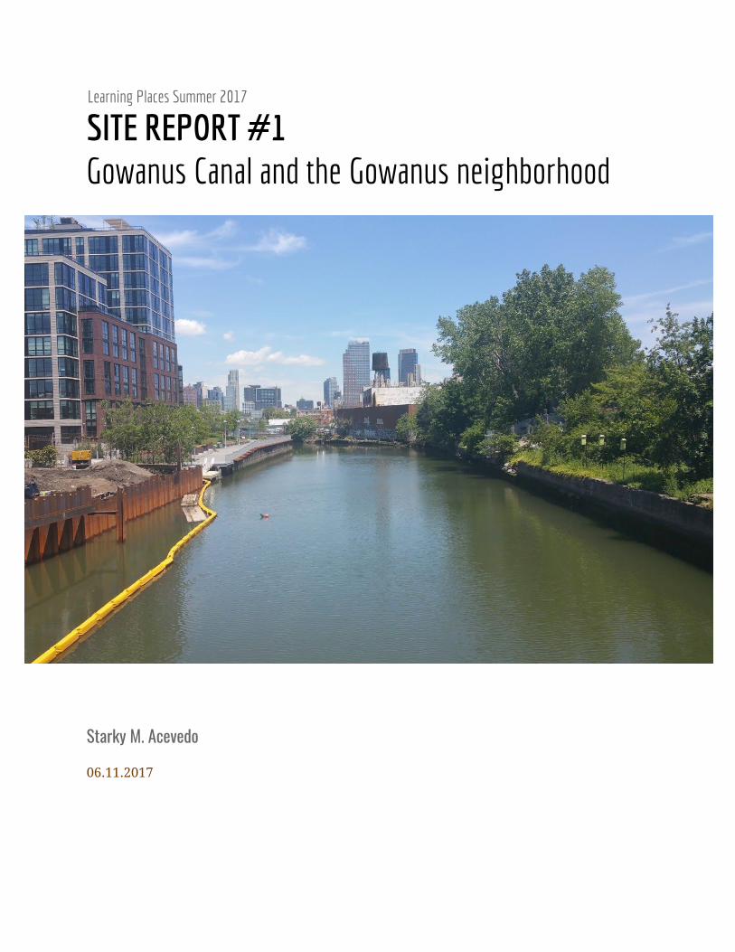
Learning Places Summer 2017
SITE REPORT #1 Gowanus Canal and the Gowanus neighborhood
Starky M. Acevedo
06.11.2017
INTRODUCTION
We started the semester by trying to get a sense of what figures like Jane Jacobs as well as Robert
Moses stood for and what type of impacts they had on communities in the city. We then used some of
the thinking and ideas of these people as well as our own experiences to analyses the Gowanus
neighborhood and the Gowanus canal first hand. The Gowanus canal is a 1.8-mile-long and
100-foot-wide canal in Brooklyn New York that empties into New York Harbor. It’s surrounding
neighborhoods are Park slope, Cobble Hill, Carroll Gardens and Red Hook. The canal was originally a
creek turned into a canal in the 19th century and was heavily used as an industrial transportation route
by companies like paper mills, gas plans and concrete manufactures. After nearly 150 years of having
industrial waste dumped into the canal as well as becoming a sewage dump for the surrounding
neighborhood it has becomes one of America's most polluted sites, even becoming a superfund site. The
first Despite the conditions of the canal the neighborhood is still attracting a lot of attention and
becoming a target for big time developers bringing with them a new wave of gentrification.
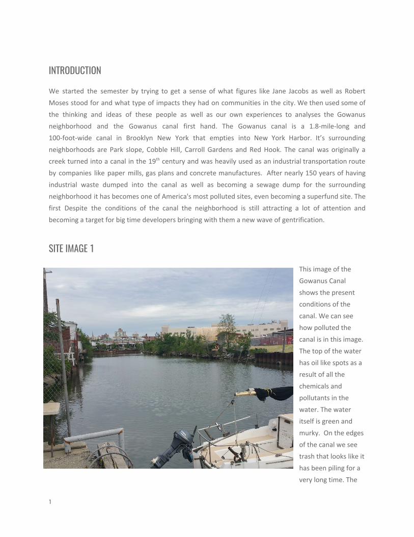
SITE IMAGE 1
This image of the
Gowanus Canal
shows the present
conditions of the
canal. We can see
how polluted the
canal is in this image.
The top of the water
has oil like spots as a
result of all the
chemicals and
pollutants in the
water. The water
itself is green and
murky. On the edges
of the canal we see
trash that looks like it
has been piling for a
very long time. The
1
border conditions of the canal seem to be in all different types of conditions, in some areas it has been
reinforced either by siding or sheet piling but other sections of the border seem to not have any border
at all.
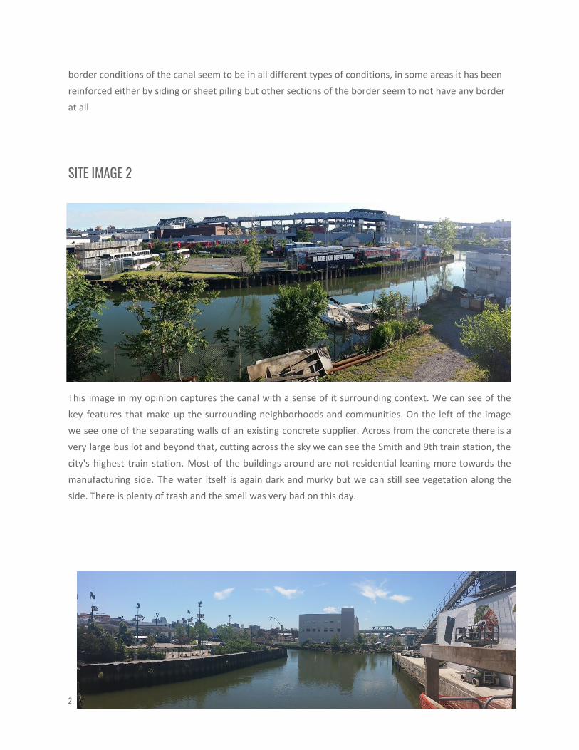
SITE IMAGE 2
This image in my opinion captures the canal with a sense of it surrounding context. We can see of the
key features that make up the surrounding neighborhoods and communities. On the left of the image
we see one of the separating walls of an existing concrete supplier. Across from the concrete there is a
very large bus lot and beyond that, cutting across the sky we can see the Smith and 9th train station, the
city's highest train station. Most of the buildings around are not residential leaning more towards the
manufacturing side. The water itself is again dark and murky but we can still see vegetation along the
side. There is plenty of trash and the smell was very bad on this day.
2

SITE IMAGE 3
In the image above we can see some of the results of developers doing what they do. To the left of the
image is a relatively new Whole Foods. The entire yard of the whole foods is designed to be permeable
to account for possible flooding, whether it works well or not is yet to be tested. The Whole foods seems
to be somewhat ecofriendly as we can see the solar panels as well as wind towers. On their parking lot,
they also have chargers for electric cars. However along with a whole food comes along unaffordable
prices for the residents in the area, this being a sign of the gentrification to come. We can also see one
of the canals tributary branches. One of the canals most interesting features is it bends and turns.
SITE IMAGE 4
One of the ways some in the community
are trying to reduce the amount of
pollutants reaching the canal is by using
bioswales. Bioswales reduce the
amount of storm water reaching the
canal by absorbing some of it like a
sponge and removing some of the
toxins and pollutants found in runoff
storm water. Bioswales are designed
with an inlet and an outlet, allowing for
water to enter and leave. It is important
to note the difference between a tree
pit and a bioswale. This bioswale is
6-foot-deep and can absorb up to 2
million gallons of water. The vegetation
found in bioswales needs to be very
resilient and ideally native in order to
resist the pollutants. One of the
drawbacks to bioswales is that they
require a bit of maintenance.
3
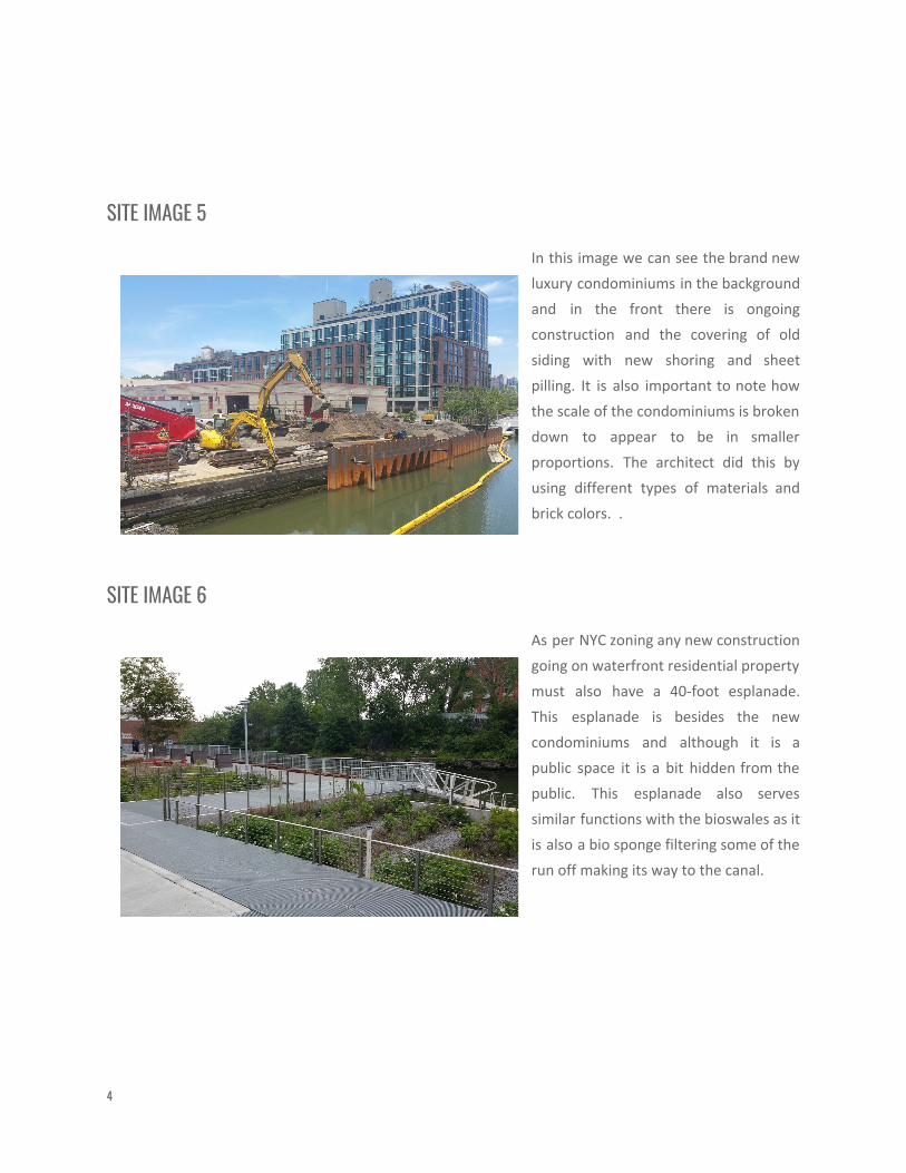
SITE IMAGE 5
In this image we can see the brand new
luxury condominiums in the background
and in the front there is ongoing
construction and the covering of old
siding with new shoring and sheet
pilling. It is also important to note how
the scale of the condominiums is broken
down to appear to be in smaller
proportions. The architect did this by
using different types of materials and
brick colors. .
SITE IMAGE 6
As per NYC zoning any new construction
going on waterfront residential property
must also have a 40-foot esplanade.
This esplanade is besides the new
condominiums and although it is a
public space it is a bit hidden from the
public. This esplanade also serves
similar functions with the bioswales as it
is also a bio sponge filtering some of the
run off making its way to the canal.
4
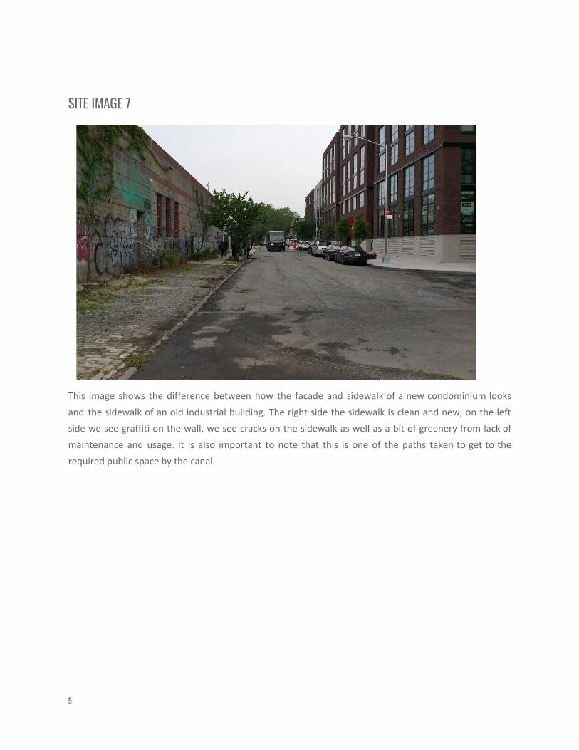
SITE IMAGE 7
This image shows the difference between how the facade and sidewalk of a new condominium looks
and the sidewalk of an old industrial building. The right side the sidewalk is clean and new, on the left
side we see graffiti on the wall, we see cracks on the sidewalk as well as a bit of greenery from lack of
maintenance and usage. It is also important to note that this is one of the paths taken to get to the
required public space by the canal.
5
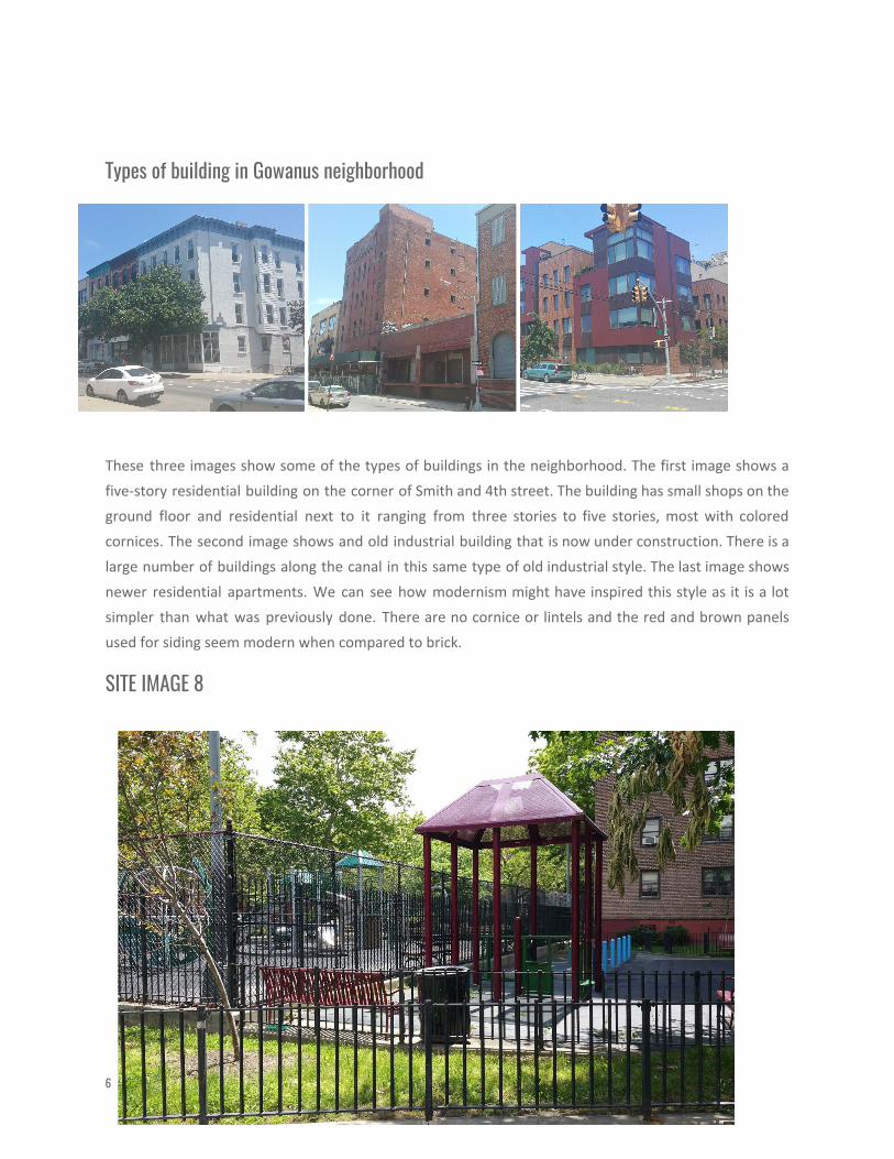
Types of building in Gowanus neighborhood
These three images show some of the types of buildings in the neighborhood. The first image shows a
five-story residential building on the corner of Smith and 4th street. The building has small shops on the
ground floor and residential next to it ranging from three stories to five stories, most with colored
cornices. The second image shows and old industrial building that is now under construction. There is a
large number of buildings along the canal in this same type of old industrial style. The last image shows
newer residential apartments. We can see how modernism might have inspired this style as it is a lot
simpler than what was previously done. There are no cornice or lintels and the red and brown panels
used for siding seem modern when compared to brick.
SITE IMAGE 8
6
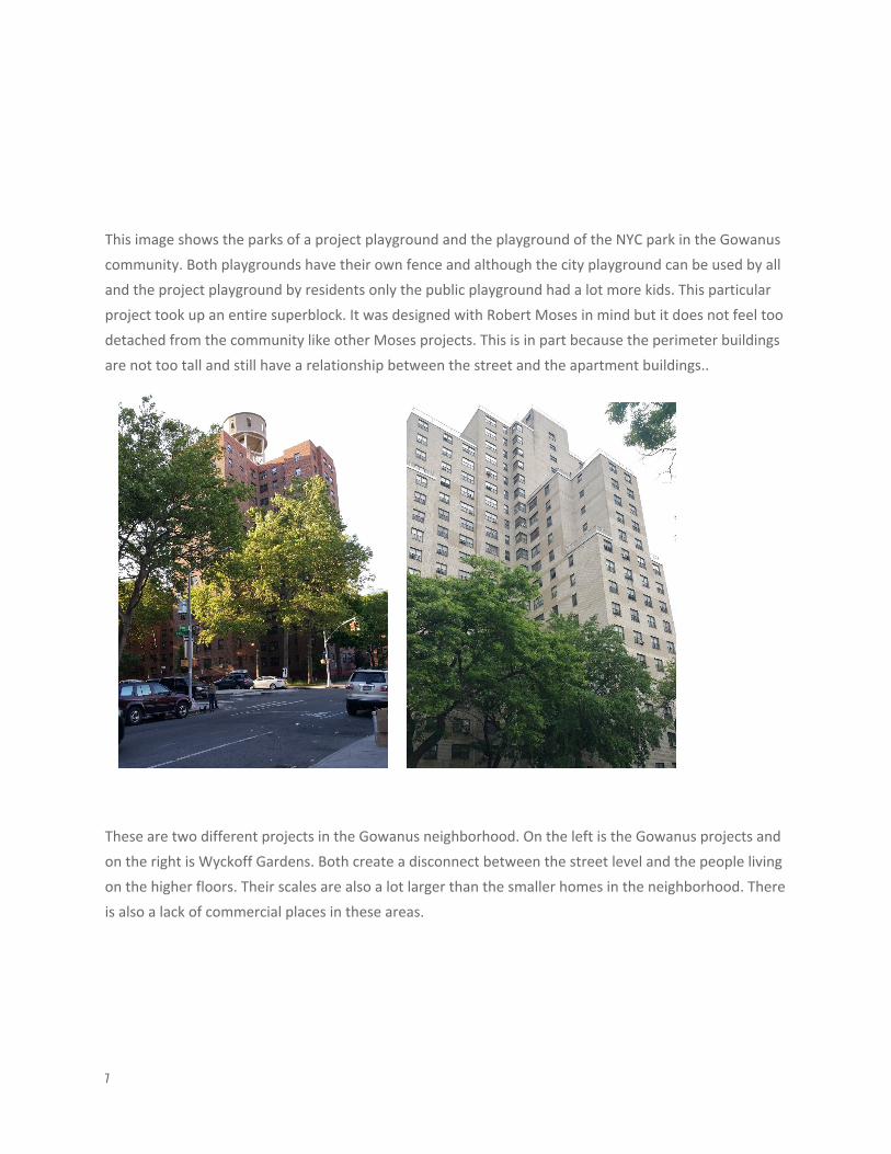
This image shows the parks of a project playground and the playground of the NYC park in the Gowanus
community. Both playgrounds have their own fence and although the city playground can be used by all
and the project playground by residents only the public playground had a lot more kids. This particular
project took up an entire superblock. It was designed with Robert Moses in mind but it does not feel too
detached from the community like other Moses projects. This is in part because the perimeter buildings
are not too tall and still have a relationship between the street and the apartment buildings..
These are two different projects in the Gowanus neighborhood. On the left is the Gowanus projects and
on the right is Wyckoff Gardens. Both create a disconnect between the street level and the people living
on the higher floors. Their scales are also a lot larger than the smaller homes in the neighborhood. There
is also a lack of commercial places in these areas.
7
SKETCHES
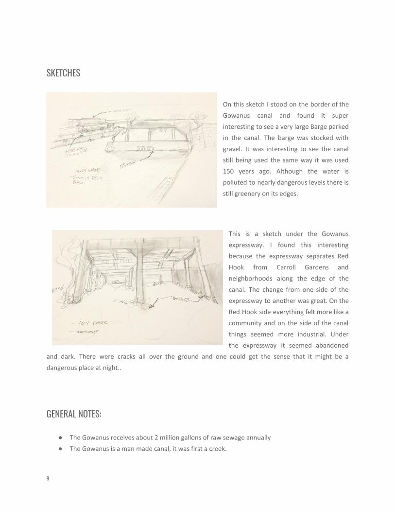
On this sketch I stood on the border of the
Gowanus canal and found it super
interesting to see a very large Barge parked
in the canal. The barge was stocked with
gravel. It was interesting to see the canal
still being used the same way it was used
150 years ago. Although the water is
polluted to nearly dangerous levels there is
still greenery on its edges.
This is a sketch under the Gowanus
expressway. I found this interesting
because the expressway separates Red
Hook from Carroll Gardens and
neighborhoods along the edge of the
canal. The change from one side of the
expressway to another was great. On the
Red Hook side everything felt more like a
community and on the side of the canal
things seemed more industrial. Under
the expressway it seemed abandoned
and dark. There were cracks all over the ground and one could get the sense that it might be a
dangerous place at night..
GENERAL NOTES:
● The Gowanus receives about 2 million gallons of raw sewage annually
● The Gowanus is a man made canal, it was first a creek.
8
● Although highly contaminated there is some life in the canal. Some of the species in the canal
include jellyfish, crabs and small types of fish
● In 2009 the U.S Environmental Protection Agency (EPA) proposed the cal become a superfund
site. This would make all involved parties in the pollution of the site partly responsible.
● Bioswales can hold up to 2,000 gallons of water, making them a very effective way to filter
toxins out of runoff storm water
INSIGHTS/DISCOVERIES
In about two weeks of class the way I think of neighborhoods and communities has changed, in my
opinion for the better. Our first class we were introduced to Jane Jacobs and she would remind the city
of New York specifically developers what it meant to be a community. To Jane Jacobs a community does
not happen overnight. The creation of a community is an organic process. This need to have the process
be planned is one of the many faults Jane Jacobs found in the way developers like Robert Moses were
designing our cities. One of the reasons I feel that developers had a hard time understanding the organic
process that is the creation of a community is because they looked at the city from a plan view and only
saw roads, avenues and streets. Another one of Jacob's points that is obvious to me now when
experiencing the city is that developers were designing for cars not people. The automobile industry was
booming and this meant that cars where the target not people. On the other hand, Jacobs believes
people are the driving force behind a community, even helping keep it safe by having as many eyes in
the streets as possible. I also enjoyed learning about these figures and what they stood for and then
going out into the city to actually see what Jane Jacobs meant by eyes on the streets and seeing people
greet each other. Being able to somewhat experience what a deaccent project feel like and what a really
bad one feels like makes it easier to see what Jane Jacobs was fighting for and fighting against. I also got
the sense that at one point developers like Robert Moses had better intentions but somewhere along
the line only money mattered. I had an idea of how the process worked but it was not until reading
about Jane Jacobs and all those being pushed out that it hit me how ruthless developers can be. The
used the Zoning codes to their advantage to change districts to whatever benefits their pocket usually
residential. The film My Brooklyn helped me understand what people go though as a result of urban
renewal and gentrification. It also helped me begin to recognize some of the forces behind
gentrification, some of those being class, race and above all money. I have also gained a new
appreciation for the Gowanus canal and not because of the overpriced condominiums going up but for
the history of the canal. It deserves to be restored and preserved. Perhaps we need to reevaluate how
we utilize the canal.
9
KEYWORDS/VOCABULARY & DEFINITIONS
Combined Sewage Overflow: Combined sewer systems are sewers that are designed to collect
rainwater runoff, domestic sewage, and industrial wastewater in the same pipe. Most of the time,
combined sewer systems transport all their wastewater to a sewage treatment plant, where it is treated
and then discharged to a water body.
Coal Tar: Coal-tar is formed when coal is cooked, a process to prepare coal for use as a fuel.
Wastewater treatment: process used to convert wastewater- which is water no longer needed or
suitable for its most recent use - into an effluent that can be either returned to the water cycle with
minimal environmental issues or reused.
Saltmarsh: A saltmarsh, also known as a coastal salt marsh or a tidal marsh, is a coastal ecosystem in the
upper coastal intertidal zone between land and open saltwater or brackish water that is regularly
flooded by the tides..
Flushing tunnel: Pulls water from harbor to head of the canal. This result in water that contains low
amounts of oxygen.
Bioswale: Bioswales are landscape elements designed to concentrate on remove silt and pollution from
surface runoff water.
Brownfield site: The Environmental Protection Agency (EPA) defines brownfield as "real property, the
expansion, redevelopment, or reuse of which may be complicated by the presence or potential presence
of a hazardous substance, pollutant, or contaminant".
Superfund Site: Superfund sites are polluted locations requiring a long-term response to clean up
hazardous material contaminations. The party or parties involved are usually responsible of the cleanup.
Esplanade: any open level space open for public use.
Boulevard: A broad street, promenade, or walk, planted with rows of trees. Chiefly applied to streets of
this kind in Paris, or to others which it is intended to compare to them. Now freq. (esp. in U.S.), a wide or
well laid-out street or avenue.
10
Gentrification: The process by which an (urban) area is rendered middle-class
Impervious: Surface that does not allow any liquid through.
Pervious: Surface that allows the passage of water through.
Sheet piling: sheet piles are long structural sections with a vertical interlocking system that creates a
continuous wall. The walls are most often used to retain either soil or water.
Cornice: A horizontal ornamental molding along the edge of the building. Most commonly found at the
top of the front of the building.
Superblocks: An above average block usually formed as a result of a large development project where
smaller blocks are combined forming a super block.
Projects: A government-subsidized housing development with relatively low rents.
Modernism: A style or movement in the arts that aims to break with classical and traditional forms.
Zoning: The process of dividing land in a municipality into zones (e.g. residential, industrial) in which
certain land uses are permitted or prohibited.
QUESTIONS for Further RESEARCH
1. Is enough attention being placed on replacing the outdated infrastructure of the sewage system
in the Gowanus neighborhood?
2. Is the city of New York not a major contributor to the pollution of the canal making it partially
responsible for its rehabilitation as per its status as a superfund site?
3. Are the new residents moving into the Gowanus neighborhood aware of how dirty the canal
11
actually is?
4. Is the gentrification of the Gowanus what it takes to get the canal cleaned up?
ZONING RESOLUTION THE CITY OF NEW YORK. (n.d.). Retrieved June 11, 2017, from
https://www1.nyc.gov/assets/planning/download/pdf/zoning/zoning-text/art10c07.pdf?r=2
Superfund Site Information. (2016, December 28). Retrieved June 11, 2017, from
https://cumulis.epa.gov/supercpad/cursites/csitinfo.cfm?id=0206222
Oxford English Dictionary.. Retrieved June 11, 2017, from
https://library.citytech.cuny.edu/research/articles/oxford-english- dictionary
Goanus canal. Retrieved June 11, 2017, from
http://www.nyc.gov/html/dep/html/harborwater/gowanus_canal_history.shtml
12


