Spring 2010 Teaching with Primary Sources Quarterly Learning Activity – Elementary Level Investigating the Building Blocks of Our Community’s Past, Present and Future Waynesburg, Greene County, Pennsylvania, 1897. Drawn by T. M. Fowler. Library of Congress Geography and Map Division, Washington, D.C. Library of Congress: http://www.loc.gov/resource/g3824w.pm008700 OVERVIEW Overview This activity is intended to introduce a project-based learning unit on the built environment—all buildings, spaces and products created or modified by people. Students analyze a historic map of their local community to better understand its evolving built environment, and identify questions for research based on findings. The class develops a plan for investigating how their local community’s built environment reflects its past, present and future. Project-based learning extension ideas include facilitating a community walking tour led by a local historian and hosting a culminating community event for students to share their primary source-based research. Objectives After completing this learning activity, students will be able to: analyze a map as a primary source; locate and describe components of the built environment using a historic map; and, develop a plan for investigating a variety of primary sources to better understand how their local built environment reflects their community’s past, present and future. Time Required One to two 45-minute class periods; activity extension ideas require additional class periods. Recommended Grade Range 4-6 Topic/s Architecture, Landscape; Cities, Towns; Maps Subject Geography Standards McREL 4 th Edition Standards & Benchmarks http://www.mcrel.org/compendium/browse.asp The Library of Congress http://www.loc.gov/teachers/tps/quarterly/project_learning/pdf/elementary_activity.pdf
Transcript
Spring 2010 Teaching with Primary Sources Quarterly Learning Activity – Elementary Level
Investigating the Building Blocks of Our Community’s Past, Present and Future
Waynesburg, Greene County, Pennsylvania, 1897. Drawn by T. M. Fowler. Library of Congress Geography and Map Division, Washington, D.C. Library of Congress: http://www.loc.gov/resource/g3824w.pm008700
OVERVIEW Overview This activity is intended to introduce a project-based learning unit on the built environment—all buildings, spaces and products created or modified by people. Students analyze a historic map of their local community to better understand its evolving built environment, and identify questions for research based on findings. The class develops a plan for investigating how their local community’s built environment reflects its past, present and future. Project-based learning extension ideas include facilitating a community walking tour led by a local historian and hosting a culminating community event for students to share their primary source-based research. Objectives After completing this learning activity, students will be able to: analyze a map as a primary source; locate and describe components of the built environment using a historic map; and, develop a plan for investigating a variety of primary sources to better understand how their
local built environment reflects their community’s past, present and future. Time Required One to two 45-minute class periods; activity extension ideas require additional class periods. Recommended Grade Range 4-6 Topic/s Architecture, Landscape; Cities, Towns; Maps Subject Geography Standards McREL 4th Edition Standards & Benchmarks http://www.mcrel.org/compendium/browse.asp
Spring 2010 Teaching with Primary Sources Quarterly Learning Activity – Elementary Level
OVERVIEW (CONT’D) Historical Understanding Standard 2. Understands the historical perspective Geography Standard 4. Understands the physical and human characteristics of place Standard 6. Understands that culture and experience influence people’s perceptions of places and regions
Credits Adapted from “Windows on Waynesburg, Windows on Your Town,” a unit plan created by Andrea Buchanan, a participant in the TPS program at Waynesburg University, Pennsylvania. PREPARATION This activity introduces historical map analysis, but assumes students are familiar with the parts of a map: compass, scale, title, orientation, etc. Before leading students through the activity, teachers should familiarize themselves with their selected local map’s historical context. Teachers may also want to complete the online module, “Analyzing Primary Sources: Maps,” http://www.loc.gov/teachers/professionaldevelopment/selfdirected/ Materials Have these materials ready before the activity. -Print a copy of the following guide for your own use and of the student tool:
o Teacher’s Guide to Analyzing Maps http://www.loc.gov/teachers/usingprimarysources/resources/Analyzing_Photographs_and_Prints.pdf
o Primary Source Analysis Tool http://www.loc.gov/teachers/usingprimarysources/resources/Primary_Source_Analysis_Tool.pdf
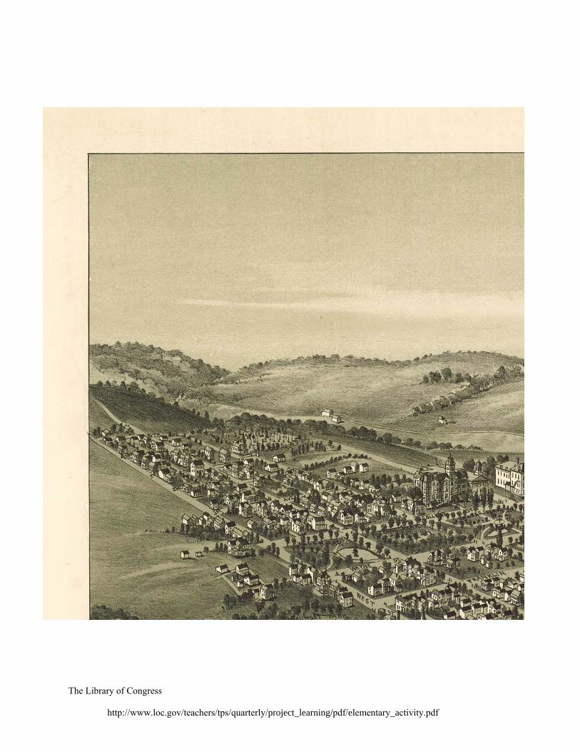
-Print the following map in multiple sections (see attached).* Print enough copies of each section to distribute one section per student (hold onto sections with map title information):
o Waynesburg, Greene County, Pennsylvania, 1897. Drawn by T.M. Fowler. http://hdl.loc.gov/loc.gmd/g3824w.pm008700
*Note: This map is specific to the town of Waynesburg in Greene County, Pennsylvania. To locate items specific to your local community, search the Library of Congress Web site (www.loc.gov), including: American Memory, http://memory.loc.gov/ammem/index.html Map Collections, http://lcweb2.loc.gov/ammem/gmdhtml/gmdhome.html Prints & Photographs Online Catalog, http://www.loc.gov/pictures/ You may also need to search local or state library or museum digital archives. For instructions on viewing, resizing and printing high resolution maps: http://www.loc.gov/teachers/professionaldevelopment/selfdirected/maps/PDF/UsingMaps.pdf The Library of Congress
Spring 2010 Teaching with Primary Sources Quarterly Learning Activity – Elementary Level
PROCEDURE 1. Before introducing the focus of this project-based learning unit, guide the class through a
basic analysis of a historic map of their local community. 2. Begin by passing out copies of the different map sections (one per student) and of the
Primary Source Analysis Tool. Ask students to look closely at their map sections. 3. Using the Teacher’s Guide to Analyzing Maps, help students to complete the analysis tool.
Key questions include: Observe: What do you see? What place or places does the map show? Reflect: Why do you think this map was made? When do you think it was made? Question: What do you wonder about? Who? What? Where? When? Why? How?
4. Ask students to find others with the same section of the map and to compare and discuss their
findings as a group. What details do they notice? What questions do they have about this map? 5. Have each student group share their map section findings with the entire class. Following
each group’s presentation, pose questions to the class for discussion, including: How does this new evidence fit together with information from the other map sections? Does this evidence confirm or eliminate your earlier ideas about the map’s creator,
purpose, time period, audience, etc.? Why? 6. Assemble the entire map by asking each group to place a copy of its map section on a large
table after presenting their findings. Invite the entire class to help fit together the sections, adding any previously undistributed map title sections last.
7. After the class has identified this primary source as an historic map of their local community,
introduce the focus of this project-based learning unit: How does our local community’s built environment reflect its past, present and future?
8. Help students locate and describe graphic elements on the historic map that represent the
community’s “built environment,” i.e., all buildings, spaces and products created or modified by people. Key discussion questions include: What can you find represented on this map that appears made by people for living (e.g.,
houses)? Working (e.g., factories, stores)? Learning? (e.g., schools)? Playing (e.g., parks)? Worshipping (e.g., churches?) Getting to and from (e.g., streets, train tracks)?
What else can you find on this map that represents the built environment? 9. Discuss how the community’s built environment has changed over time and create a class
chart of findings and ideas. If possible, compare the historic map’s built environment features to those on a current map of the same community. Key discussion questions include: Which buildings, streets, parks or other built environment features are the same, if any? How has our community’s built environment changed? Point to evidence on the maps. How do you think local or national historic events or inventions may have helped shape
our community’s built environment? Prompt as needed (e.g., the invention of cars). The Library of Congress
Spring 2010 Teaching with Primary Sources Quarterly Learning Activity – Elementary Level
PROCEDURE (CONT’D) 10. Assign students to work in their small groups to brainstorm how they might investigate their
questions about this historic map to better understand how their local community’s built environment reflects its past, present and future.
11. Explain that each group will write and present responses to the following questions: Identify 2-3 features of our community’s built environment—a building, park, street—
you’d like to research. What specific questions do you have about them? List 5 different strategies for investigating the history of our community’s built
environment. How might we share our class’s investigative findings with our community? Be creative!
12. Encourage students to consider how their investigations will use:
a) primary sources - original documents and objects from the time under study (e.g., maps, photographs, oral histories); and, b) secondary sources - accounts or interpretations of events created by someone without firsthand knowledge (e.g., textbooks, biographies).
13. When groups are ready, invite them to take turns sharing and discussing their responses with
the class. As groups present, create a master list of groups’ selected built environment features and ideas for investigating and sharing findings.
14. As a class, review the list and develop a plan for investigating how their local community’s
built environment reflects its past, present and future. EVALUATION - Students’ active participation in guided class discussions - Students’ completed Primary Source Analysis Tool - Students’ active participation in independent group work, including written and verbal
presentation of responses to the group questions PROJECT-BASED LEARNING EXTENSIONS Guide students in one or more of the following individual or group activities: - Search the Library of Congress Web site (www.loc.gov)’s digitized collections (identify
specific ones) for primary and secondary sources relating to your community, county, state, or national history from the time period under study. Research a specific aspect of the local community’s built environment (a building, park, neighborhood, etc.) using primary and secondary sources from a local library or museum.
- Create a class timeline of local, state and national historical events beginning with the
community’s establishment and continuing to the present.
PROJECT-BASED LEARNING EXTENSION IDEAS (CONT’D) - Participate in a walking tour led by a local historian or long-time community resident.
Students prepare questions in advance and bring notebooks on the tour for writing notes. - Observe and document the local built environment by taking a walking field trip around town
with sketchbooks, cameras and binoculars. - Identify current locations of historic photographs of the local built environment and try to
recreate the photographs for comparison. For example, students may locate a street corner photographed with buildings that have been replaced by a parking lot, and take a new photograph from the same point-of-view.
- Interview an older family member or a long-standing community member about how the
local built environment (or a specific aspect of it) has evolved and why. Students develop questions, practice interviewing skills, conduct and record interviews, type transcripts, etc.
- Create a scale model or drawing of a local building that demonstrates understanding of its
evolving usage and appearance. - Write a creative story about a local building’s history from the perspective of the building
itself, i.e. “if these walls could talk,” including a prediction for its future. - Share primary-source based research findings with community members about how their
local built environment reflects its past, present and future. Presentation methods include: o exhibiting primary source facsimiles with exhibit labels, timelines, etc. in a display
case at the local library; o developing an online presentation for posting on a class or school web site, and/or; o presenting via PowerPoint at a school board or city council meeting.
- Write a reflective memoir of the overall project-based learning experience.