SSS 10 Proceedings of the 10th International Space Syntax Symposium Y İnce Güney & A S Kubat Gender and urban space: The case of Sharjah, Uae 106:1 106 Gender and urban space: The case of Sharjah, UAE Yasemin İnce Güney Balikesir University [email protected]Ayse Sema Kubat Istanbul Technical University [email protected]Abstract The aim of this study is to objectively examine the effects of gender on public space use in historical core of Sharjah, the third largest emirate in the United Arab Emirates, by utilizing space syntax techniques. An earlier study, which syntactically analysed the city of Sharjah focusing specifically on the effects of the modern developments on its urban structure, has already declared the dominance of male movement in the heritage area. The current study analysed the visibility properties of the heritage area of the city of Sharjah and correlated them with the observed pedestrian movement patterns to interrogate if there is any property of space itself that correlates with the gender differences of its users. The study also aims to raise some discussions for space syntax research agenda on the topic of gendered public space use. Keywords Sharjah, historic city centre, space syntax, gender, visibility. 1. Introduction In various cultures and at different historical periods, women have been identified with private spaces, spaces that are owned and used privately, while public spaces, spaces that are open and accessible to everyone were meant to be used mostly by men. It has been argued that the traditional division of labour where men are the family breadwinners is a major source of this segregation: Women are naturally associated with private spaces as their traditional role requires them to stay at home and look after their children, while men are expected to use public spaces in their role as breadwinners. Space syntax, is one of the significant research programs developed during the twentieth century to investigate the relationship between human societies and space, and it specifically focused on the effects of the physical properties of the space on observed patterns of human copresence and movement. However, within the space syntax literature, gender issues have only been raised in studies of domestic spaces and even though there has been considerable quantitative research conducted on human movement patterns in urban spaces it is only recently that the issue of gender differences in an urban context has been raised (Nes, 2009; Ince Guney, 2014). The aim of this study is to objectively examine the effects of gender on public space use in historical core of Sharjah, the third largest emirate in the United Arab Emirates, by utilizing space syntax techniques. The research utilizes the pedestrian counts conducted in 2011 by the authors for an earlier study (Kubat et al., 2014). The current study also conducted the visibility analysis of the
Transcript
SSS10 Proceedings of the 10th International Space Syntax Symposium
Y İnce Güney & A S Kubat Gender and urban space: The case of Sharjah, Uae
106:1
106 Gender and urban space: The case of Sharjah, UAE
The aim of this study is to objectively examine the effects of gender on public space use in historical core of Sharjah, the third largest emirate in the United Arab Emirates, by utilizing space syntax techniques. An earlier study, which syntactically analysed the city of Sharjah focusing specifically on the effects of the modern developments on its urban structure, has already declared the dominance of male movement in the heritage area. The current study analysed the visibility properties of the heritage area of the city of Sharjah and correlated them with the observed pedestrian movement patterns to interrogate if there is any property of space itself that correlates with the gender differences of its users. The study also aims to raise some discussions for space syntax research agenda on the topic of gendered public space use.
Keywords
Sharjah, historic city centre, space syntax, gender, visibility.
1. Introduction
In various cultures and at different historical periods, women have been identified with private spaces, spaces that are owned and used privately, while public spaces, spaces that are open and accessible to everyone were meant to be used mostly by men. It has been argued that the traditional division of labour where men are the family breadwinners is a major source of this segregation: Women are naturally associated with private spaces as their traditional role requires them to stay at home and look after their children, while men are expected to use public spaces in their role as breadwinners.
Space syntax, is one of the significant research programs developed during the twentieth century to investigate the relationship between human societies and space, and it specifically focused on the effects of the physical properties of the space on observed patterns of human co-‐presence and movement. However, within the space syntax literature, gender issues have only been raised in studies of domestic spaces and even though there has been considerable quantitative research conducted on human movement patterns in urban spaces it is only recently that the issue of gender differences in an urban context has been raised (Nes, 2009; Ince Guney, 2014).
The aim of this study is to objectively examine the effects of gender on public space use in historical core of Sharjah, the third largest emirate in the United Arab Emirates, by utilizing space syntax techniques. The research utilizes the pedestrian counts conducted in 2011 by the authors for an earlier study (Kubat et al., 2014). The current study also conducted the visibility analysis of the
SSS10 Proceedings of the 10th International Space Syntax Symposium
Y İnce Güney & A S Kubat Gender and urban space: The case of Sharjah, Uae
106:2
historic core of Sharjah to objectively evaluate the correlation between gendered space-‐use with that of visibility properties. In the following section, a brief history of urban city development of Sharjah is given before the methodology of the study is explained.
2. Historical background of the city of Sharjah, UAE
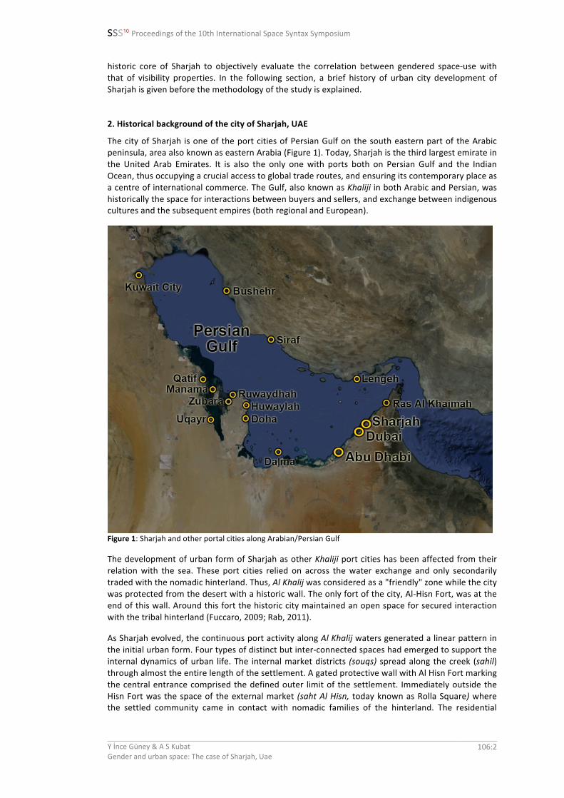
The city of Sharjah is one of the port cities of Persian Gulf on the south eastern part of the Arabic peninsula, area also known as eastern Arabia (Figure 1). Today, Sharjah is the third largest emirate in the United Arab Emirates. It is also the only one with ports both on Persian Gulf and the Indian Ocean, thus occupying a crucial access to global trade routes, and ensuring its contemporary place as a centre of international commerce. The Gulf, also known as Khaliji in both Arabic and Persian, was historically the space for interactions between buyers and sellers, and exchange between indigenous cultures and the subsequent empires (both regional and European).
Figure 1: Sharjah and other portal cities along Arabian/Persian Gulf
The development of urban form of Sharjah as other Khaliji port cities has been affected from their relation with the sea. These port cities relied on across the water exchange and only secondarily traded with the nomadic hinterland. Thus, Al Khalij was considered as a "friendly" zone while the city was protected from the desert with a historic wall. The only fort of the city, Al-‐Hisn Fort, was at the end of this wall. Around this fort the historic city maintained an open space for secured interaction with the tribal hinterland (Fuccaro, 2009; Rab, 2011).
As Sharjah evolved, the continuous port activity along Al Khalij waters generated a linear pattern in the initial urban form. Four types of distinct but inter-‐connected spaces had emerged to support the internal dynamics of urban life. The internal market districts (souqs) spread along the creek (sahil) through almost the entire length of the settlement. A gated protective wall with Al Hisn Fort marking the central entrance comprised the defined outer limit of the settlement. Immediately outside the Hisn Fort was the space of the external market (saht Al Hisn, today known as Rolla Square) where the settled community came in contact with nomadic families of the hinterland. The residential
SSS10 Proceedings of the 10th International Space Syntax Symposium
Y İnce Güney & A S Kubat Gender and urban space: The case of Sharjah, Uae
106:3
quarters (fareej) between the souqs and the wall were generally divided into two main uneven sectors located to the east and west of the Hisn Fort today known as Al Mureijah Heritage Area and Al Shuweyhein Arts Area (Figure 2).
The spaces along the sahil have persistently been used as places for interaction by Sharjah’s diverse inhabitants even after the introduction of vehicular road have disrupted the former relationships with and access to the water. Currently, the port function has been discontinued but the souq continues to exist along the sahil despite its disjointed state due to the introduction of a main thoroughfare, The Bank Street (Kubat et al., 2012a).
Figure 2: A view of Sharjah historical core (Kubat et al., 2012a)
It is with the start of the exporting of oil in 1960s that the society and economy for Khaliji part cities also started transforming themselves. For the city of Sharjah, it was after joining the United Arab Emirates in 1971 when the planned modern interventions disrupted and disconnected the traditional spaces. The planners imagined a new city encountering the desert for the first time in its history as opposed to historically defending itself from its nomadic inhabitants (Figure 3).
Figure 3: Sharjah; 1976 Air View (left) and 1994 air view (right) (Kubat et.al., 2012a)
After 1990s, as a result of modern interventions, the waterfront that once provided a vital foreground and a primary entry point to Sharjah started to act as an industrial backdrop for the larger metropolis. Sharjah now presents itself as a primarily a landed community with water inlets as
SSS10 Proceedings of the 10th International Space Syntax Symposium
Y İnce Güney & A S Kubat Gender and urban space: The case of Sharjah, Uae
106:4
a source of recreation, as opposed to a vital portal city along Al Khalij (Rab, 2011). In the 1990s, the loss of place identity resulted in the documentation and restoration of the historic buildings, demarcation of the Heritage Area, and the reconstruction of selected lost structures, including Al Hisn Fort and the city wall.
In 1998, UNESCO selected the Emirate of Sharjah as the cultural capital of the Arab World in appreciation of Sharjah’s cultural achievements and the success the Emirate has shown in preserving its heritage. It would be fair to say that Sharjah has been a historically emblematic port city in the region until recently. At present however, Sharjah’s historic centre is suffering from traffic congestion and environmental degradation that make it unattractive for visitors and inhabitants. Furthermore, the port that once satisfied the city with its vibrant lively atmosphere has been lost since the trade function is no longer allowed to take place.
Earlier syntactic analysis of Sharjah (Kubat et al., 2014) indicated that Sharjah heritage area faces a similar problem as in other Islamic cities such as Jeddah (Hillier, 2008) and Isfahan (Karimi, 1997; 2003) where the modern development of the city has caused the old city centre to lose its importance. In these cases as in Sharjah, vehicular traffic became a major focus in urban development thus increasing the scale of the context as well.
3. Methodology
The study is focused on the historic core of the city of Sharjah including the two distinct zones: Al Mureijah Heritage Area and Al Shuweyhein Arts Area, and the street that divides these areas, the Bank Street with Al Hisn Fort in the middle (Figure 4).
Figure 4: Study Area within the city of Sharjah (left) and in detail (right)
The methodology of the study includes two different analyses: pedestrian movement observations and visibility analysis. The survey of pedestrian activity to designate the relations between movement patterns and the function areas has been done using the gate method on April, 2011. Pedestrian counts were conducted at selected 130 observation points at specified locations within the historic area (Figure 5). To define daily densities in both working days and holidays the counts has been conducted on Thursday as a weekday, on a Saturday as a weekend, and on a Friday, both as a weekend and an Islamic religious holiday. The counts have distinguished five different categories of people (adult male, adult female, elderly, teenagers, and children) and one category of vehicle and were conducted for five minutes in two-‐hour time periods between 08:00 till 20:00. The observed pedestrian movement levels have been digitized to create the movement database which is then has been related to a map document showing the locations of observation points.
SSS10 Proceedings of the 10th International Space Syntax Symposium
Y İnce Güney & A S Kubat Gender and urban space: The case of Sharjah, Uae
106:5
Figure 5: The gates (left) and total pedestrian numbers observed at each gate (right)
Visibility refers to visual information provided to observers at any given location and is directly related to the geometry of space. The concept is based on Benedikt’s method of describing space taking into account the perception of the moving observer, which is referred to as the‘isovist,’as the set of all points visible from a given vantage point in space and with respect to an environment (Benedikt, 1979). Visibility analysis suggests that visual fields have their own form that result from the interaction of geometry and movement, and that the shape and size of the isovist is especially significant in relation to the information provided to the observer. In urban environments, the amount of information provided by visual fields might help the moving observer to decide where to go next. In this study, the software called depthmapX (Varoudis, 2012) has been utilized for the visibility analysis of the study area.
The next stage of the study was to comparatively evaluate the pedestrian counts and visibility analyses. In the evaluation, the overall observation data for all three days are compared with the visibility values through statistically analysing their correlation. SPSS software has been used for the correlation analysis.
4. Results
Pedestrian Activity
The relationship between pedestrian movement volumes for different categories (adult male, adult female, elderly, teenagers, and children) of people movement volume is summarized in Table 1. As can be seen from the Table, the male movement dominates the weekday and weekend and makes a peak on the religious holiday, Friday. The female pedestrian volumes are the second highest pedestrian group for movement volumes but it decreases on the weekend and even more on Friday. Movement levels of children follow female volumes and the categories elderly and teens are rather weak.
SSS10 Proceedings of the 10th International Space Syntax Symposium
Y İnce Güney & A S Kubat Gender and urban space: The case of Sharjah, Uae
Table 1: Weekday, Weekend and Friday Pedestrian Total Counts and Percentages
When we examine the figure showing the total pedestrian numbers at each observed gate (Figure 5, right), we can identify three main regions where the volumes are highest. One of them is the Al Mureijah Heritage Area located within the reconstructed historic wall where the only traditional fabric of the historic town is preserved. This is also the area where the oldest Friday Mosque of the city is located. There are some touristic shops and recreational areas as well surrounding the mosque area. The other area is the Bank Street with Al-‐Hisn Fort right in the middle. This area where all the major banks are located is one of the prestige areas of the city. It is also important to note that the southern end of the street where it meets with Al-‐Arouba Road, where there are shopping centres, is more active than the other end where it meets the Gulf. And the third area where the total pedestrian volume is higher is the southern corner of the study area where one of the highest buildings in the city, the Tower of Sharjah, is located.
Table 2 below provides the weekday and weekend pedestrian numbers and percentages for each time-‐period observed. The number of male pedestrians on weekday and weekend mornings starts low between 08:00-‐10:00 and stay low until 16:00 except the period 12:00-‐14:00 when the numbers go up a little. Between 16:00-‐18:00 there is an increase and after 18:00 until 20:00 the numbers hit their highest. However, when male pedestrian volumes are examined in terms of their percentages there is an interesting finding. Even though in earlier periods until 16:00 the numbers of male users are lower, the male percentages are still the highest. These percentages indicate that although their numbers are low in earlier periods, the males are the only ones around this time. There is a slight decrease of male percentages in the period 16:00-‐18:00, but it is the lowest on the period between 18:00-‐20:00.
This drastic drop in male user percentages in the period 18:00-‐20:00, despite the increase in their numbers, can be explained with the drastic increase in the female and child user categories in this period. Female users rise from 1400s on earlier times to 7000-‐9000s in this period; while for children the raise is between couple hundreds in earlier periods to 5000-‐7000s. Elderly and teen numbers also increase in later periods but their increase is not as drastic.
SSS10 Proceedings of the 10th International Space Syntax Symposium
Y İnce Güney & A S Kubat Gender and urban space: The case of Sharjah, Uae
106:7
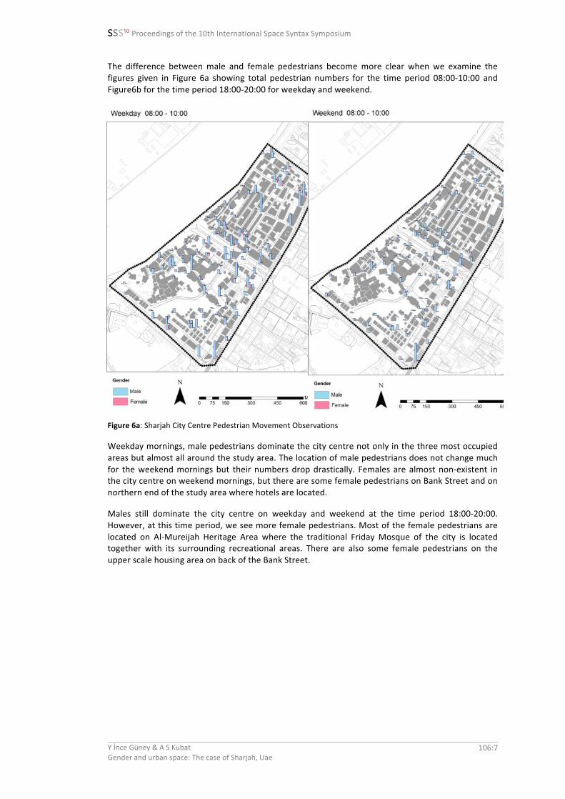
The difference between male and female pedestrians become more clear when we examine the figures given in Figure 6a showing total pedestrian numbers for the time period 08:00-‐10:00 and Figure6b for the time period 18:00-‐20:00 for weekday and weekend.
Figure 6a: Sharjah City Centre Pedestrian Movement Observations
Weekday mornings, male pedestrians dominate the city centre not only in the three most occupied areas but almost all around the study area. The location of male pedestrians does not change much for the weekend mornings but their numbers drop drastically. Females are almost non-‐existent in the city centre on weekend mornings, but there are some female pedestrians on Bank Street and on northern end of the study area where hotels are located.
Males still dominate the city centre on weekday and weekend at the time period 18:00-‐20:00. However, at this time period, we see more female pedestrians. Most of the female pedestrians are located on Al-‐Mureijah Heritage Area where the traditional Friday Mosque of the city is located together with its surrounding recreational areas. There are also some female pedestrians on the upper scale housing area on back of the Bank Street.
SSS10 Proceedings of the 10th International Space Syntax Symposium
Y İnce Güney & A S Kubat Gender and urban space: The case of Sharjah, Uae
106:8
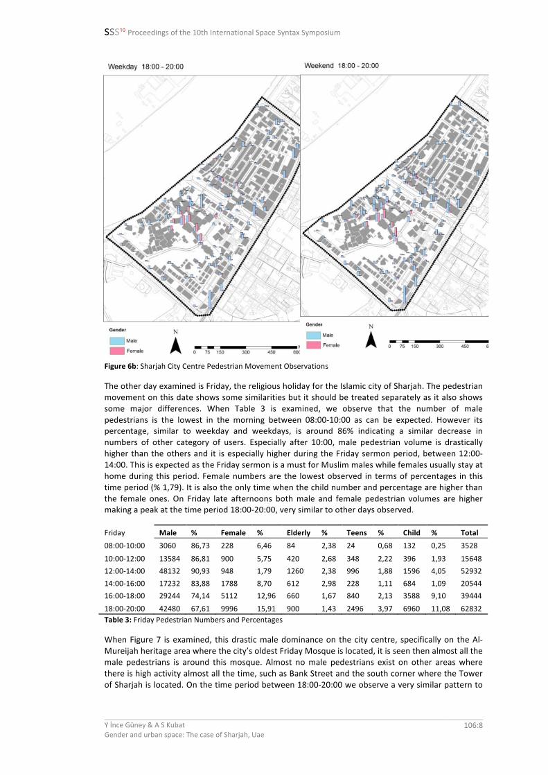
Figure 6b: Sharjah City Centre Pedestrian Movement Observations
The other day examined is Friday, the religious holiday for the Islamic city of Sharjah. The pedestrian movement on this date shows some similarities but it should be treated separately as it also shows some major differences. When Table 3 is examined, we observe that the number of male pedestrians is the lowest in the morning between 08:00-‐10:00 as can be expected. However its percentage, similar to weekday and weekdays, is around 86% indicating a similar decrease in numbers of other category of users. Especially after 10:00, male pedestrian volume is drastically higher than the others and it is especially higher during the Friday sermon period, between 12:00-‐14:00. This is expected as the Friday sermon is a must for Muslim males while females usually stay at home during this period. Female numbers are the lowest observed in terms of percentages in this time period (% 1,79). It is also the only time when the child number and percentage are higher than the female ones. On Friday late afternoons both male and female pedestrian volumes are higher making a peak at the time period 18:00-‐20:00, very similar to other days observed.
When Figure 7 is examined, this drastic male dominance on the city centre, specifically on the Al-‐Mureijah heritage area where the city’s oldest Friday Mosque is located, it is seen then almost all the male pedestrians is around this mosque. Almost no male pedestrians exist on other areas where there is high activity almost all the time, such as Bank Street and the south corner where the Tower of Sharjah is located. On the time period between 18:00-‐20:00 we observe a very similar pattern to
SSS10 Proceedings of the 10th International Space Syntax Symposium
Y İnce Güney & A S Kubat Gender and urban space: The case of Sharjah, Uae
106:9
other days, but this time the female numbers are lower and more dispersed. It is also important to note that the male numbers are highest of all days in Friday at time periods 12:00-‐14:00 and 18:00-‐20:00. Another interesting finding about Friday noon period is that the number and percentage of children user group is higher than that of females only in this period. Even though children category was not divided as male and female, we can assume that females stay at home while male children goes to Friday sermon with their male elders .
Figure 7: Sharjah City Centre Pedestrian Movement Observations
Visibility Analysis
The visibility analysis offers some specific measures that represent local and global visual characteristics of the urban spaces. The measures taken into consideration in this study include visual integration (HH) and visual connectivity values and Figure 8 provides the map of the study area coloured according to these values.
Visual connectivity value considers the number of immediate neighbours that are directly connected to a space and thus highlights local centres. As can be seen from the Figure 8, the end points of major streets that surround the study area are highlighted with red colours and almost no other red colour exist within the study area except some yellow part in the south of historical wall. This indicates that the surrounding roads that are as wide as highways are picking up most of the visual connectivity but it would be unfair to call them as local centres. Integration, on the other hand, is a global measure that describes the average depth of a space to all other spaces in the system. As can be seen from the figure, the main red coloured areas are the either ends of the Bank Street. There is also another small area at the centre of this street and west corner of the study area.
SSS10 Proceedings of the 10th International Space Syntax Symposium
Y İnce Güney & A S Kubat Gender and urban space: The case of Sharjah, Uae
For the visibility analysis the pedestrian counts were comparatively evaluated with visual integration and connectivity values for the three days observed. The analysis revealed that there were no statistically significant correlations found with the pedestrian movement levels and the visibility values.
It is interesting to observe that the roads surrounding the study such as the one next to the sea are the spaces with higher visual integration values but they are least used by pedestrians. In this case it is clear that what you can see has nothing to do with where the major pedestrian movement is located.
In an earlier study (Kubat et al., 2014)., the pedestrian as well as vehicular counts had been comparatively evaluated with spatial integration and choice values and no correlation had been found between the pedestrian movement levels and the values of the spatial structure both at the global as well as local levels. However, it was found that the total number of vehicles correlates better with both spatial integration and choice values (Table 3).
Choice (n)
Thursday Total Vehicles
Friday Total Vehicles
Saturday Total Vehicles
Choice (n) Pearson Correlation 1 ,353** ,351** ,337** N 130
Integration (n)
Thursday Total Vehicles
Friday Total Vehicles
Saturday Total Vehicles
Integration (n)
Pearson Correlation 1 ,337** ,334** ,339
N 130 Table 3: Correlations between Vehicular Movement and Choice and Integration Values (Kubat et al., 2014), **. Correlation is significant at the 0.01 level (2-‐ tailed).
SSS10 Proceedings of the 10th International Space Syntax Symposium
Y İnce Güney & A S Kubat Gender and urban space: The case of Sharjah, Uae
106:11
4. Discussion and Conclusion:
In this study, the use of public spaces based on gender differences is analysed using space syntax methodology. The context of the study is the city centre of Sharjah, UAE. The methodology of the study includes pedestrian movement observations on selected locations within the city centre and visibility analysis of this centre. The analysis revealed that there were no statistically significant correlations found with the pedestrian movement levels and the visibility values. Based on an earlier research we also know that no correlation had been found between the pedestrian movement levels and the values of the spatial structure both at the global as well as local levels but only vehicle movement correlates better with both spatial integration and choice values (Kubat et al., 2014).
The vehicular traffic has started to become major focus of urban development for Sharjah after 1970s modern interventions when the city started to develop toward the inland. This change also brought with itself a change in social and spatial structure of the historical centre while increasing the scale of the context for the city. The major demolition to open up the Bank Street for modern architectural interventions in addition to opening up the vehicular main thoroughfare on the creek show the scale of some of the modern interventions. As a result of these modern developments the connection of historic city centre with that of the larger city has been lost. Thus, even though Sharjah was selected as the cultural capital of the Arab World in 1998, in recent years the historic centre of this emblematic port city in the region has been suffering from traffic congestion and environmental degradation.
We can argue that one of the reasons why there is no correlation between pedestrian activities and visibility structures of the city centre might be related to the fact that urban fabric of the historic city centre has been mostly erased except the Al Mureijah Heritage Area inside the reconstructed city wall. Thus it would be important to examine correlations between gender and visibility structures of other historic city centres where their traditional fabrics have been protected.
Apart from vehicular emphasis, the other reason why there are no correlations between pedestrian movement and visibility structures of the study area might be related to land uses. The areas that are highly used by pedestrians is the Heritage area that houses the oldest Friday Mosque of the city, Bank Street with major banks on its either side as well as All Hisn Fort, and area with shopping centres, and touristic hotels. Specifically, the Heritage Area within the reconstructed historic wall attracts most of the pedestrians at time periods 16:00-‐18:00 and especially at 18:00-‐20:00. Furthermore, the historic landmark, the Friday Mosque of the city of Sharjah collects almost all of the movement at Friday sermon period between 12:00-‐14:00 when women disappear almost totally from the city centre.
It is also clear that the pedestrian movement in Sharjah traditional city centre is dominated by males making a peak on religious holiday Friday. From the results of earlier studies, it is also possible to suggest that the density of male users is mostly higher than that of females in various city centres (Ince Guney, 2014; Kubat et al., 2007; Nes, 2009).
However, it is not so easy to separate the spaces as belonging to males or females. The public space use in Al Mureijah Heritage Area clearly shows that urban public spaces can be fluid as their use changes based on different times. When it is Friday sermon time only the males, young and old, occupy the area, but when it is late afternoon the space is used by males and females together. Thus we can say that the use of public spaces in the traditional city centre is impermanent, shifting and interacting dynamically with activity and time. Still, it is possible to suggest that the cities are formed in such a way that it leads to gender differences in the use of urban spaces inviting males more than females.
Space syntax theory, on the other hand, argues that the geometric and topologic architecture of the urban grid is the most powerful shaper of urban movement patterns. It is further suggested that through its effect on movement flows, the architecture of the street network influences the evolution of land use patterns and consequently the whole pattern of life in the city. The process is defined and well-‐known as ‘cities as movement economies’. As such they are inseparable from the social structure of the society.
SSS10 Proceedings of the 10th International Space Syntax Symposium
Y İnce Güney & A S Kubat Gender and urban space: The case of Sharjah, Uae
106:12
To conclude, it is interesting to note that in the case of Sharjah there were no correlations between the pedestrian movement flows and the syntactic and visibility properties. As Hillier suggests, if how we understand and move in the city is what creates the city, then as space syntax researchers we might need to rethink our way of defining spatial representation and abstract properties of space and relate them to a gendered perspective of urban space use.
References
Fuccaro, N. (2009), Histories of City and State in the Persian Gulf: Manama since 1800. Cambridge: Cambridge University Press.
Hillier, B. (1999), ‘The Common Language of Space: a way of looking at the social, economic and environmental functioning of cities on a common basis’. In Journal of Environmental Sciences, Vol. 3 (11) p.3-‐42.
Hillier, B. (2007), ‘A Theory of the City As Object: or, How Spatial Laws Mediate The Social Construction Of Urban Space’. In Urban Design International, Vol. 7, p.153–179.
Hillier, B. (2008), ‘Using space syntax to regenerate the historic centre of Jeddah or why we need architectural models of whole cities’, presented at UIA World Congress, Torino.
Ince Guney, Y. (2014), ‘Gender and Urban Space: An Examination of a Small Anatolian City’. In Journal of Faculty of Architecture, ITU A/Z, Vol. 11 (2), p.153-‐174.
Karimi, K. (1997), ‘The Spatial Logic of Organic Cities in Iran and the United Kingdom’. In: Major, M. D. and Amorim, L. and Dufaux, D. (eds.), Proceedings of the First International Space Syntax Symposium, London: University College London, p.06.1-‐06.17.
Karimi, K. (2003), ‘The tale of two cities: Urban planning of the city of Isfahan in the past and present’. In: Hanson, J. (ed.), Proceedings of the Fourth International Space Syntax Symposium, London: University College London, p.14.1-‐14.16
Kubat, A. S., Ince Guney, Y. and Ozer, O. (2014), ‘Historic City Centers Under Threat: The Case of Sharjah, UAE’. In Journal of Faculty of Architecture ITU A/Z, Vol. 11(2) p.131-‐151.
Kubat, A. S., Rab,S., Ince Guney, Y., Ozer, O. and Kaya, S. (2012a), ‘Application of Space Syntax in Developing A Regeneration Framework for Sharjah’s Heritage Area’. In: Greene, M., Reyes, J. and Castro, A. (eds.), Proceedings of the Eight International Space Syntax Symposium, Santiago De Chile, p.8040.1-‐8040.16.
Kubat, A. S., Rab,S., Ince Guney,Y., Ozer, O. and Kaya, S. (2012b), Final Report of the research project titled “Application of Space Syntax in Developing a Research Framework for Sharjah’s (UAE) Heritage Area", supported by the Emirates Foundation, UAE.
Rab, S. (2011), ‘Sharjah: Seascape Urbanism in a Khaliji Port City’. In Proceedings of ACSA Association of Collegiate Schools of Architecture Annual Meeting, Montreal, Canada.
Batty, M. (2001), ‘Exploring Isovist Fields: Space and Shape in Architectural and Urban Morphology’. In Environment and Planning, B: Planning and Design, Vol.28, p.123-‐150.
Benedikt, M. (1979), ‘To Take Hold of Space: Isovists and Isovist Fields’ In Environment and Planning B: Planning and Design, Vol.6, p.47-‐65.
Mackenzie, S. (1989), ‘Women in the City’. In: R. Peet and N. Thrift (eds.), New Models in Geography, London: Unwin Hyman Ltd, p.109-‐126.
McDowell, L. (1983), ‘Towards an Understanding of the Gender Division of Urban Space’. In Environment and Planning D: Society and Space, Vol.1 (1), p.59-‐72.
Nes, A. V. (2009), ‘Gender Differences in the Urban Environment: The Flaneur and Flaneuse of the 21st Century’. In Koch, D. Marcus, L. and Steen, J. (eds.), Proceedings of the Seventhh International Space Syntax Symposium, Stockholm, Royal Institute of Technology, p.
Turner, A., O’Sullivan, D. and Penn, A. (2001), ‘From Isovists to Visibility Graphs’. In Environment and Planning B, Vol.28 (1), p.103-‐120.


![SSS10-K as filed for website and printer[1] · PDF filemarket presence and operating efficiencies. ... Thank you for your continued support. DEAR FELLOW SHAREHOLDER: Robert J. Attea](https://static.documents.pub/doc/80x56/5abe18ef7f8b9a8e3f8c95d3/sss10-k-as-filed-for-website-and-printer1-presence-and-operating-efficiencies.jpg)


