Staff Report Z-64-19-4 (U-Haul Smart Mobility Center Flagship Store Planned Unit Development) December 31, 2020 Encanto Village Planning Committee Meeting Date: January 11, 2021 Planning Commission Hearing Date: February 4, 2021 Request From: P-2 TOD-1 (Parking, Interim Transit Oriented Zoning Overlay District One) (0.94 acres) Request To: PUD (Planned Unit Development) (0.94 acres) Proposed Use: Planned Unit Development to allow a self- service storage facility, household moving center, car sharing, and all uses permitted in WU Code T5:7 (commercial and residential) Location: Approximately 238 feet west of the southwest corner of 3rd Street & Thomas Road Owner: Amerco Real Estate Company Applicant and Representative: Parul Butala, Amerco Real Estate Staff Recommendation: Approval, subject to stipulations General Plan Conformity General Plan Land Use Map Designation Commercial Street Map Classification Thomas Road Arterial Varies, 42 to 45 foot south half street STRENGTHEN OUR LOCAL ECONOMY CORE VALUE; EMPLOYERS (JOB CREATION); LAND USE PRINCIPLE: Support General Plan Land Use Map and zoning changes that will facilitate the location of employment generating uses in each of the designated employment centers. The Planned Unit Development proposes the expansion of the existing U-Haul International Headquarters with a flagship model for their Smart Mobility Centers. This expansion will allow for the creation of a facility complementary to the existing campus and support the continued growth of a major employer in Midtown Phoenix. The site is also located within the North Central Employment Center.
Transcript
Staff Report Z-64-19-4 (U-Haul Smart Mobility Center Flagship Store Planned Unit Development)
Request To: PUD (Planned Unit Development) (0.94 acres)
Proposed Use: Planned Unit Development to allow a self-service storage facility, household moving center, car sharing, and all uses permitted in WU Code T5:7 (commercial and residential)
Location: Approximately 238 feet west of the southwest corner of 3rd Street & Thomas Road
Owner: Amerco Real Estate Company
Applicant and Representative: Parul Butala, Amerco Real Estate
Staff Recommendation: Approval, subject to stipulations
General Plan Conformity
General Plan Land Use Map Designation Commercial
Street Map Classification
Thomas Road Arterial Varies, 42 to 45 foot south half street
STRENGTHEN OUR LOCAL ECONOMY CORE VALUE; EMPLOYERS (JOB CREATION); LAND USE PRINCIPLE: Support General Plan Land Use Map and zoning changes that will facilitate the location of employment generating uses in each of the designated employment centers. The Planned Unit Development proposes the expansion of the existing U-Haul International Headquarters with a flagship model for their Smart Mobility Centers. This expansion will allow for the creation of a facility complementary to the existing campus and support the continued growth of a major employer in Midtown Phoenix. The site is also located within the North Central Employment Center.
Staff Report: Z-64-19-4 December 31, 2020 Page 2 of 15
CONNECT PEOPLE AND PLACES CORE VALUE; COMPLETE STREETS; DESIGN PRINCIPLE: In order to balance a more sustainable transportation system, development should be designed to include increased amenities for transit, pedestrian and bicyclists such as shade, water, seating, bus shelters, wider sidewalks, bike racks, pedestrian scale lighting and way-finding. The Planned Unit Development adopts or exceeds many of the standards contained in the Walkable Urban Code as recommended by the Midtown Transit Oriented Development Policy Plan with a special focus on creating a strong pedestrian environment with ample shade, amenities, and a bicycle repair station.
CONNECT PEOPLE AND PLACES CORE VALUE; CORES, CENTERS, AND CORRIDORS: Plan cores, centers and corridors to include a variety of land uses: office, retail shopping, entertainment and cultural, housing, hotel and resort, and where appropriate, some types of industry. The Planned Unit Development proposes the expansion of the existing U-Haul International Headquarters with a flagship model for their Smart Mobility Centers. This expansion, located within the Encanto Village Primary Core, will allow for the creation of a facility complementary to the existing campus and the growing residential presence along the light rail corridor.
CELEBRATE OUR DIVERSE COMMUNITIES AND NEIGHBORHOODS CORE VALUE; CERTAINTY AND CHARACTER; DESIGN PRINCIPLE: Create new development or redevelopment that is sensitive to the scale and character of the surrounding neighborhoods and incorporates adequate development standards to prevent negative impact(s) on the residential properties. The Planned Unit Development proposes standards consistent with the scale and character of the surrounding area including the built environment and the environment envisioned by the Midtown Transit Oriented Development Policy Plan.
BUILD THE SUSTAINABLE DESERT CITY CORE VALUE; TREES AND SHADE; DESIGN PRINCIPLE: Integrate trees and shade into the design of new development and redevelopment projects throughout Phoenix. The Planned Unit Development proposes enhanced tree planting standards to create a strong tree landscape along Thomas Road in a manner that will create thermal comfort for pedestrians and mitigate the impact of the urban heat island effect.
Staff Report: Z-64-19-4 December 31, 2020 Page 3 of 15
Applicable Plans, Overlays, and Initiatives
Transit Oriented Development Strategic Policy Framework: Background Item No. 5.
Midtown Transit Oriented Development Plan: Background Item Nos. 6 and 7.
Tree and Shade Master Plan: Background Item No. 17.
Background/Issues/Analysis SUBJECT SITE 1. This request is to rezone the site from P-2 TOD-1 (Parking, Interim Transit
Oriented Zoning Overlay District One) to PUD (Planned Unit Development) to allow a self-service storage facility, household moving center, car sharing, and all uses permitted in WU Code T5:7. The proposed U-Haul Smart Mobility Center Flagship Store is intended as an extension of the international headquarter campus which is located between 3rd Street and Central Avenue on the east and west respectively and Thomas Road and Virginia Avenue on the north and south respectively.
2. The General Plan Land Use Map designation for the subject site is Commercial which is consistent with the land uses proposed. All surrounding properties also have Commercial General Plan Land Use Map designations. The Transit Oriented Development Strategic Policy Framework and the Midtown Transit Oriented Development Policy Plan provide additional guidance on appropriate development on this site; See Background Item Nos. 5 through 7.
Staff Report: Z-64-19-4 December 31, 2020 Page 4 of 15
SURROUNDING LAND USE AND ZONING
3. The subject site is currently surface parking utilized by its owner, U-Haul. The site is surrounded by commercial and high intensity multifamily residential land uses and entitlements. East: Located to the east of the subject site is a surface parking lot which is zoned for R-5 R-I TOD-1 (Multifamily Residence District, Residential Infill, Interim Transit Oriented Zoning Overlay District One). Beyond the above described zone are sites zoned R-5 TOD-1 (Multifamily Residence District, Interim Transit Oriented Zoning Overlay District One) and P-1 TOD-1 (Passenger Automobile Parking, Interim Transit Oriented Zoning Overlay District One) and used for medical office and parking respectively.
Figure B: Zoning Context Map
Source: Planning and Development
West: Located to the west of the subject site is a three-story office building zoned C-1 HRI TOD-1 (Neighborhood Retail, High-Rise Incentive District, Interim Transit Oriented Zoning Overlay District One). South: Located to the south of the subject site, the western one-third is a surface parking lot zoned P-1 TOD-1 (Parking, Interim Transit Oriented Zoning Overlay District One) and the eastern two-thirds being surface parking for a larger office development which is zoned R-5 R-I TOD-1 (Multifamily Residence District, Residential Infill, Interim Transit Oriented Zoning Overlay District One) North (across Thomas Road): Located to the north of the subject site, across Thomas Road, is a four story multifamily complex known as “The Thomas at Midtown” which is zoned PUD (Planned Unit Development) through Rezoning Case No. Z-9-15-4 and permits a maximum height of 70 feet.
Staff Report: Z-64-19-4 December 31, 2020 Page 5 of 15
TRANSIT ORIENTED DEVELOPMENT POLICY
4. The subject site is at a key location regarding transportation and planning investments relevant to the redevelopment of the site. T2050 Bus Rapid Transit: The subject site is located immediately adjacent to Thomas Road which is identified in the T2050 plan as a future bus rapid transit corridor. The Public Transit Department is currently in the process of soliciting public outreach to determine the first three corridors that will receive Bus Rapid Transit as part of the foundational network for the future system and Thomas Road is a finalist. Transit Oriented Development Strategic Policy Framework: The subject site is located within 600 feet from the light rail station located at Central Avenue and Thomas Road. An overview of policy guidance from this framework is provided in Background Item No. 5. Midtown Transit Oriented Development Policy Plan: The subject site is located within the boundaries of the Midtown Transit Oriented Development Policy Plan. An overview of policy guidance from this framework is provided in Background Item Nos. 6 and 7.
5. The Transit Oriented Development Strategic Policy Framework.
The Strategic Policy Framework is part of the General Plan which identified planning typologies to describe urban environments. The Framework identifies a Place Type for each light rail station and radiating outward to the one-quarter and one-half mile distances from each station. The nearest light rail stations to this site are Central Avenue and Thomas Road (600 feet from the site) which is designated as a Regional Center Place Types.
Figure C: Place Type Map from the TOD Strategic Policy Framework
Staff Report: Z-64-19-4 December 31, 2020 Page 6 of 15
The Regional Center Place Type is intended to produce regional destinations with a high level of regional accessibility with high intensity development ranging from 5 to 10 stories, and up to 20 stories when certain cities priorities are met. The proposed development allows a maximum height of 66 feet (approximately 6 stories) which is consistent with the scale recommended of the framework and, as an extension to the U-Haul campus, expands a major employment destination.
6. ReinventPHX Midtown Transit Oriented Development Policy Plan. The site is located within the Midtown TOD (Transit Oriented Development) Policy Planning Area; in addition to a blueprint for how to create a walkable and transit oriented environment, the plan recommends regulatory transects for key parcels and includes a series of illustrative master plans to depict key concepts.
As depicted on Figure D, the plan recommends Walkable Urban Code Transect 5:7 (WU Code T5:7) for this site. The Planned Unit Development defers broadly to the uses and development standards contained in WU CodeT5:7 and is consistent with the scale and intensity in the plan.
Staff Report: Z-64-19-4 December 31, 2020 Page 7 of 15
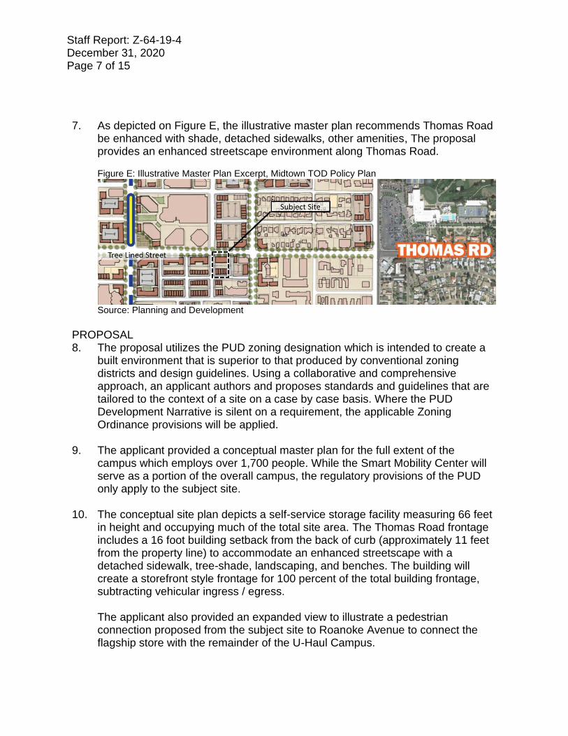
7. As depicted on Figure E, the illustrative master plan recommends Thomas Road be enhanced with shade, detached sidewalks, other amenities, The proposal provides an enhanced streetscape environment along Thomas Road.
Figure E: Illustrative Master Plan Excerpt, Midtown TOD Policy Plan
Source: Planning and Development
PROPOSAL
8. The proposal utilizes the PUD zoning designation which is intended to create a built environment that is superior to that produced by conventional zoning districts and design guidelines. Using a collaborative and comprehensive approach, an applicant authors and proposes standards and guidelines that are tailored to the context of a site on a case by case basis. Where the PUD Development Narrative is silent on a requirement, the applicable Zoning Ordinance provisions will be applied.
9. The applicant provided a conceptual master plan for the full extent of the campus which employs over 1,700 people. While the Smart Mobility Center will serve as a portion of the overall campus, the regulatory provisions of the PUD only apply to the subject site.
10. The conceptual site plan depicts a self-service storage facility measuring 66 feet
in height and occupying much of the total site area. The Thomas Road frontage includes a 16 foot building setback from the back of curb (approximately 11 feet from the property line) to accommodate an enhanced streetscape with a detached sidewalk, tree-shade, landscaping, and benches. The building will create a storefront style frontage for 100 percent of the total building frontage, subtracting vehicular ingress / egress. The applicant also provided an expanded view to illustrate a pedestrian connection proposed from the subject site to Roanoke Avenue to connect the flagship store with the remainder of the U-Haul Campus.
Staff Report: Z-64-19-4 December 31, 2020 Page 8 of 15
11. The conceptual elevations depict a modern design with several materials on each building face, ground floor glazing oriented to Thomas Road beyond that required by code, two storefront entries, and a showroom / retail space accessible from Thomas Road.
Figure F: Conceptual Building Elevations (Top, Thomas Road Frontage; Bottom Left, East Elevation; Bottom Right, West Elevation)
Source: RKAA Architects
Below is a summary of the regulatory standards for the subject site as described in the attached PUD narrative date stamped December 10, 2020.
12. Land Use The narrative defers broadly to the Walkable Urban Code Transect 5:7 (WU T5:7) regarding permitted uses with one exception; whereas the self-service storage, truck and car sharing and rentals, and household moving center are not permitted by the Walkable Urban Code, the PUD permits these uses by right as an extension of the U-Haul International Headquarters Campus.
Staff Report: Z-64-19-4 December 31, 2020 Page 9 of 15
13. Development Standards The Planned Unit Development utilize the vast majority of the development standards contained in the Walkable Urban Code Transect 5:7 Midtown with few modifications; below is a summary of the development standards, including those which defer directly to the Walkable Urban Code and those which deviate from the Walkable Urban Code Walkable Urban Code, No Changes:
• Section 1305: Frontage Standards o Storefront Proposed.
• Section 1310: Open Space o None Required.
Walkable Urban Code, Deviations:
• Section 1303: Transect Lot Standards o Height: 66 foot maximum, 80 feet permitted by WU Code T5:7. o Glazing: 0 percent glazing on 6th floor, 25 percent required by WU
Code T5:7.
• Section 1304: General Site Development Standards o One hundred percent shade over the public sidewalk, 75 percent
required by WU Code T5:7.
• Section 1307: Parking Standards o Vehicle Parking, 28 vehicle parking spaces for the proposed use,
WU Code T5:7 does not contain a standard for self-service storage / household moving center.
o Bicycle Fix-It Station, publicly accessible from Thomas Road.
• Section 1308: Signage o Add a 7 foot by 16 foot lifestyle graphic banner.
• Section 1309: Landscape Standards: o Caliper of shade trees enhanced beyond WU Code T5:7
• Section 1312: Character Area Standard o The PUD adopts with the Transit Midtown Character Area
standards which require a minimum sidewalk width of six feet with a five foot landscape area. The PUD further enhances this standard by requiring larger caliper shade trees, four architectural benches, and stamped concrete at the vehicular entrance to the building.
Staff is recommending Stipulation Nos. 1.b. through 1.e. to more clearly govern the development standards that apply within the PUD.
Staff Report: Z-64-19-4 December 31, 2020 Page 10 of 15
14. Design Guidelines The Planned Unit Development applies the provisions of Section 507 Tab A (Guidelines for Design Review) and of Section 1311 (WU Code, Design Development Considerations) in the Phoenix Zoning Ordinance.
15. Signage
The Development Narrative details the exact type and quantity of signage permitted. The most notable deviation is a proposed “lifestyle graphic” that will be mounted on the Thomas Road façade, constructed of a high-quality mesh material, and measuring a maximum dimension of 7 feet by 16 feet. Staff is proposing Stipulation Nos. 1.c. and 1.f. to provide additional guidance on this type of signage not addressed by signage requirements in the Phoenix Zoning Ordinance, nor in the Hearing Draft of this Planned Unit Development.
16. Sustainability
The narrative proposes several sustainability elements including bicycle parking, automated lights, high efficiency building materials, and incorporating programmatic elements such as a “take a box, leave a box” and a “reuse center” to allow customers to share moving materials and to give new life to discarded possessions.
STUDIES AND POLICIES 17. Tree and Shade Master Plan.
The Tree and Shade Master Plan encourages treating the urban forest as infrastructure to ensure the trees are an integral part of the City’s planning and development process. Sidewalks on the street frontages should be detached from the curbs to allow trees to be planted on both sides of the sidewalk to provide thermal comfort for pedestrians and to reduce the urban heat island effect. The Planned Unit Development contains regulatory standards for enhanced tree plantings and architectural shade over the Thomas Road sidewalk which will enhance thermal comfort and generally reduce the urban heat island effect.
18. Complete Streets Guidelines In 2014, the City of Phoenix City Council adopted the Complete Streets Guiding Principles. The principles are intended to promote improvements that provide an accessible, safe, connected transportation system to include all modes, such as bicycles, pedestrians, transit, and vehicles.
Staff Report: Z-64-19-4 December 31, 2020 Page 11 of 15
The Planned Unit Development contains regulatory standards to require a detached sidewalk along Thomas Road in addition to bicycle amenities including a bicycle repair station.
19. Comprehensive Bicycle Master Plan: The Comprehensive Bicycle Master Plan is a guide for creating a culture and environment conducive to bicycling as a viable mode of transportation. The proximity to high capacity transit underscores the importance of walking and bicycling in this area. The Planned Unit Development contains regulatory standards for enhanced bicycle facilities on the site to allow for bicycles to become a viable mode of transportation, including for multimodal trips with transit; pursuant to these standards, the development will provide secure bicycle parking for its employees and include a bicycle repair station that is accessible to the public.
20. Reimagine Phoenix As part of the Reimagine Phoenix Initiative, the City of Phoenix is committed to increasing the waste diversion rate to 40 percent by 2020 and to better manage its solid waste resources. The provision of recycling containers was not addressed in the applicant’s submittals; however, the applicant has committed to including a “reuse center” on the site where so their patrons can “take a box / leave a box”, save discarded items from the landfill through reuse, and by partnering with local non-profits to put discarded products to good use.
COMMUNITY INPUT SUMMARY 21. As of the writing of this report, staff has received no correspondence regarding
the request. INTERDEPARTMENTAL COMMENTS 22. The Fire Department commented that the site plan must comply with the
Phoenix Fire Code and that water supply and pressure is unknown and that additional supply may be required to meet the required fire flow per the Phoenix Fire Code.
23. The Public Works Department, Floodplain Management Division determined the
parcel is not in a Special Flood Hazard Area (SFHA), but located in a Shaded Zone X, on panel 1710 L of the Flood Insurance Rate Maps (FIRM) dated October 16, 2013.
Staff Report: Z-64-19-4 December 31, 2020 Page 12 of 15
24. The Water Services Department commented that there is existing water and sewer mains in the area with the potential to serve the development but issued their standard caveat that capacity is a dynamic issue.
25. The Public Transit Department commented that the developer shall provide a
system of clearly defined and accessible pedestrian pathways from all building entrances and exits to the public sidewalk as a means of promoting efficient connections toward transit infrastructure. This item is addressed in the Walkable Urban Code which is referenced within the Planned Unit Development as a regulatory element.
26. The Street Transportation Department commented that the developer shall
construct all streets within and adjacent to the development and, further, that the driveway on Thomas Road shall restrict left-turn egress; these items are addressed in Stipulation Nos. 2 and 3.
OTHER 27. The site has not been identified as being archaeologically sensitive. However, in
the event archaeological materials are encountered during construction, all ground disturbing activities must cease within 33-feet of the discovery and the City of Phoenix Archaeology Office must be notified immediately and allowed time to properly assess the materials. This is addressed in Stipulation No. 3.
28. The Aviation Department requires that the property owner record a Notice to
Prospective Purchasers of Proximity to Airport in order to disclose the existence, and operational characteristics of City of Phoenix Sky Harbor International Airport (PHX) to future owners or tenants of the property. The Aviation Department also requires that the project receive a No Hazard Determination from the FAA. These are addressed in Stipulation Nos. 4 and 5.
29. Development and use of the site are subject to all applicable codes and
ordinances. Zoning approval does not negate other ordinance requirements. Other formal actions such as, but not limited to, zoning adjustments and abandonments may be required.
Findings 1. The development is consistent with the Commercial General Plan Land Use Map
designation and the Regional Center Place Type as identified in the Transit Oriented Development Strategic Policy Framework.
Staff Report: Z-64-19-4 December 31, 2020 Page 13 of 15
2. The development is consistent in scale, architectural design, and streetscape enhancements as recommended by the Transit Oriented Development Strategic Policy Framework, the Midtown Transit Oriented Development Policy Plan, and the Midtown Character Area Standards contained in the Walkable Urban Code section of the Phoenix Zoning Ordinance.
3. The development will activate an underutilized parcel at a prime location in
Midtown Phoenix and in close proximity to the U-Haul International Headquarters Campus.
Stipulations 1. An updated Development Narrative for the U-Haul Smart Mobility Center Flagship
Store PUD reflecting the changes approved through this request shall be submitted to the Planning Department within 30 days of City Council approval of this request. The updated Development Narrative shall be consistent with Development Narrative date stamped December 11, 2020 as modified by the following stipulations.
a. Front Cover: Add “City Council adopted: [Insert Adoption date]” below “Hearing Draft: December 10, 2021.
b. Page 12: Revise the table entry for Parking Standards to: delete Bullet No. 1 regarding bicycle parking and to modify Bullet No. 2 to specify that the bicycle repair station shall be installed outside the building, in a conspicuous location, and accessible from the public sidewalk.
c. Page 12: Revise the table entry for Signage Standards to read as follows: “The PUD will meet the requirements of this section aside from one deviations and requirements found in Section E. Signs on page 14.”
d. Page 12: Revise the table entry for Landscape Standards to read as
follows: “The PUD will meet the requirements of this section, as applicable to the T5:7 transect, with the additional requirement that the Thomas Road frontage be planted with a minimum of seven (7) drought tolerant shade trees with 25 percent four-inch caliper and the remainder being three-inch caliper or greater.
e. Page 13: Revise the table entry for Character Areas to read as follows: “The PUD will meet the requirements of this section, as applicable to the T5:7 Transect, for the Transit Midtown Character Area, with three additions and clarifications…:
Staff Report: Z-64-19-4 December 31, 2020 Page 14 of 15
i. Delete Bullet No. 1
ii. Modify Bullet No. 2 to read “Trees as required per the Section 1309
and as modified by the Section 1309 reference in this table, in addition to shrubs to provide 75% groundcover between the sidewalk and the building frontage, excluding vehicular driveways.
f. Page 14 and 15: Delete the table beginning with “Sign Type” in the upper
left cell, delete the remaining paragraph, and replace with the below language:
i. “To govern signage on the site, the development shall adhere to the following conditions, as approved by the Planning and Development Department:”
i. The wall mural (lifestyle graphic) shall not exceed 112 square feet in area and a maximum height of 46 feet.
ii. Prior to the issuance of any sign permits within the PUD, a Comprehensive Sign Plan will be adopted in accordance with the procedures in Section 705.E.2.
iii. Signs over 56 feet in height shall be incorporated into the approved or amended Comprehensive Sign Plan.
iv. In order to reduce lighting impacts to nearby residential uses, the maximum luminance (brightness) for all wall signs shall be 80 Nits measured at the sign face. The maximum color temperature for all wall signs shall be 4,000 Kelvin. Sign permit applicants shall provide certification from a qualified registrant of compliance with these lighting standards prior to the issuance of permits for wall signs.
2. The driveway on Thomas Road shall be restricted to a three-quarter access
prohibiting left-turn egress constructed per City of Phoenix modified Standard Detail P1243-1, or as approved or modified by the Street Transportation Department.
3. In the event archaeological materials are encountered during construction, the
developer shall immediately cease all ground-disturbing activities within a 33-foot
Staff Report: Z-64-19-4 December 31, 2020 Page 15 of 15
radius of the discovery, notify the City Archaeologist, and allow time for the Archaeology Office to properly assess the materials.
4. The developer shall provide a No Hazard Determination for the proposed
development from the FAA pursuant to the FAA’s Form-7460 obstruction analysis review process, prior to construction permit approval, as per plans approved by the Planning and Development Department.
5. The property owner shall record documents that disclose the existence, and
operational characteristics of Phoenix Sky Harbor Airport to future owners or tenants of the property. The form and content of such documents shall be according to the templates and instructions provided which have been reviewed and approved by the City Attorney.
Writer Nick Klimek December 31, 2020 Team Leader Samantha Keating Exhibits Zoning sketch map Aerial sketch map U-Haul Smart Mobility Center PUD