SOP-4.7.4 The Clean Water Team Guidance Compendium for Watershed Monitoring and Assessment State Water Resources Control Board, 4.7.4-SOP-(TB)V3 2006 1 Standard Operating Procedure (SOP) 4.7.4. By Erick Burres * Fish Habitat Survey Definitions Riffles Shallow reaches with swiftly flowing turbulent water with some partially exposed substrate; gradient <4%, substrate is usually cobble dominated. Steep reaches of moderately deep, swift, and very turbulent water, amount of exposed substrate is relatively high; gradient is >4%, and substrate is boulder dominated.
Transcript
SOP-4.7.4
The Clean Water Team Guidance Compendium for Watershed Monitoring and Assessment State Water Resources Control Board, 4.7.4-SOP-(TB)V3 2006 1
Standard Operating Procedure (SOP) 4.7.4.
By Erick Burres *
Fish Habitat Survey Definitions
Riffles
Shallow reaches with swiftly flowing turbulent water with some partially exposed substrate; gradient <4%, substrate is usually cobble dominated.
Steep reaches of moderately deep, swift, and very turbulent water, amount of exposed substrate is relatively high; gradient is >4%, and substrate is boulder dominated.
SOP-4.7.4
The Clean Water Team Guidance Compendium for Watershed Monitoring and Assessment State Water Resources Control Board, 4.7.4-SOP-(TB)V3 2006 2
Cascade
The steepest riffle habitat, consisting of alternating small waterfalls and shallow pools; substrate is usually bedrock and boulders.
A thin sheet of water flowing over a smooth bedrock surface; gradients are usually variable.
SOP-4.7.4
The Clean Water Team Guidance Compendium for Watershed Monitoring and Assessment State Water Resources Control Board, 4.7.4-SOP-(TB)V3 2006 3
Flatwaters
Swiftly flowing reaches with little surface agitation and no major flow obstructions; often appears as flooded riffles; typical substrate consists of gravel, cobble, and boulders.
A sequence of runs separated by short riffle steps; substrate is usually cobble and boulder dominated.
SOP-4.7.4
The Clean Water Team Guidance Compendium for Watershed Monitoring and Assessment State Water Resources Control Board, 4.7.4-SOP-(TB)V3 2006 4
A wide uniform channel bottom; flow with low to moderate velocities; lacking pronounced turbulence; substrate usually consists of cobble, gravel, and sand.
A section of swift flowing stream containing numerous boulders or other large obstructions which create eddies or scour holes (pockets) behind the obstructions.
Deleted: large obstructions
SOP-4.7.4
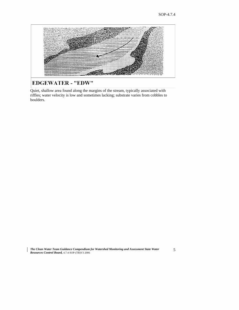
The Clean Water Team Guidance Compendium for Watershed Monitoring and Assessment State Water Resources Control Board, 4.7.4-SOP-(TB)V3 2006 5
Quiet, shallow area found along the margins of the stream, typically associated with riffles; water velocity is low and sometimes lacking; substrate varies from cobbles to boulders.
SOP-4.7.4
The Clean Water Team Guidance Compendium for Watershed Monitoring and Assessment State Water Resources Control Board, 4.7.4-SOP-(TB)V3 2006 6
Main Channel Pools
A series of pools separated by short riffles or cascades; generally found in high gradient, confined mountain streams dominated by boulder substrate.
Channel cross-sections typically "U" shaped with bedrock or coarse grained bottom flanked bedrock walls; current velocities are swift and the direction of flow is uniform.
SOP-4.7.4
The Clean Water Team Guidance Compendium for Watershed Monitoring and Assessment State Water Resources Control Board, 4.7.4-SOP-(TB)V3 2006 7
Large pools formed by mid-channel scour; the scour hole encompasses more than 60% of the wetted channel; water velocity is slow, and the substrate is highly variable.
Large pools formed at the confluence of two or more channels; scour can be due to plunges, lateral obstructions or scour at the channel intersections; velocity and turbulence are usually greater than those in other pool types.
Deleted: 
SOP-4.7.4
The Clean Water Team Guidance Compendium for Watershed Monitoring and Assessment State Water Resources Control Board, 4.7.4-SOP-(TB)V3 2006 8
Scour Pools
Found where stream passes over a complete or nearly complete channel obstruction and drops steeply into the streambed below, scouring out a depression; often large and deep; substrate size is highly variable.
Lateral scour pools formed at the bend in the channel; these pools are common in the lowland valley bottoms where stream banks consist of alluvium and lack hard obstructions.
SOP-4.7.4
The Clean Water Team Guidance Compendium for Watershed Monitoring and Assessment State Water Resources Control Board, 4.7.4-SOP-(TB)V3 2006 9
Formed by flow impinging against a partial channel obstruction consisting of large woody debris; the associated scour is generally confined to <60% of the wetted channel width.
Formed by flow impinging against a partial channel obstruction consisting of a root wad; associated scour is generally confined to <60% of the wetted channel width.
SOP-4.7.4
The Clean Water Team Guidance Compendium for Watershed Monitoring and Assessment State Water Resources Control Board, 4.7.4-SOP-(TB)V3 2006 10
Formed by flow impinging against a bedrock stream bank; associated scour is generally confined to <60% of the wetted channel width.
Formed by flow impinging against a partial channel obstruction consisting of a boulder; the associated scour is generally confined to <60% of the wetted channel.
SOP-4.7.4
The Clean Water Team Guidance Compendium for Watershed Monitoring and Assessment State Water Resources Control Board, 4.7.4-SOP-(TB)V3 2006 11
Backwater Pool
Water impounded from a complete or nearly complete channel blockage (debris jams, rock landslides or beaver dams); substrate tend toward smaller gravel and sand.
Typically found in the summer, these pools will dry up or have very little flow; mainly associated with gravel bars and may contain sand and silt substrate.
SOP-4.7.4
The Clean Water Team Guidance Compendium for Watershed Monitoring and Assessment State Water Resources Control Board, 4.7.4-SOP-(TB)V3 2006 12
Found along channel margins and caused by eddies around a boulder obstruction; these pools are usually shallow and are dominated by fine-grain substrate; current velocities are quite low.
Found along channel margins and caused by eddies around a root wad obstruction; these pools are usually shallow and are dominated by fine-grain substrate; current velocities are quite low.
SOP-4.7.4
The Clean Water Team Guidance Compendium for Watershed Monitoring and Assessment State Water Resources Control Board, 4.7.4-SOP-(TB)V3 2006 13
Found along channel margins and caused by eddies around a large woody debris obstruction; these pools are usually shallow and are dominated by fine-grain substrate; current velocities are quite low. * References: Coyote Creek Riparian Station and the San Francisco Estuary Institute originally prepared this protocol for the Clean Water Team. Originally adapted from the California Department of Fish and Game’s California Salmonid Stream Habitat Manual. 2nd Edition by from G. Flosi. and F.L. Reynolds. This SOP reflects changes made in 2006 by the Clean Water Team.