23
Denver Parks & Recreation STRATEGIC ACQUISITION PLAN June 2021
Denver Parks & RecreationSTRATEGIC ACQUISITION PLAN
June 2021
The Denver Parks and Recreation (DPR) Strategic Acquisition Plan project was funded by the National Recreation and Parks Association 10-Minute Walk Grant and the Parks Legacy Fund.
Acknowledgements
Denver Parks and RecreationAllegra “Happy” Haynes, Executive Director
Scott Gilmore, Deputy Executive Director
John Martinez, Deputy Executive Director
Gordon Robertson, Director Parks Planning, Design and Construction
Kathleen LeVeque, Co-Project Manager, Assistant Director of Parks Planning
DENVER PARKS AND RECREATION CORE PLANNING TEAM
Joseph Lovell, GIS Data Administrator
Gregory Neitzke, Land Surveyor
Laurie Tabachnick, Associate Parks Planner
Laura Morales, Community Relations
Department of Finance, Division of Real EstateJeffrey Steinberg, Director
Lisa Lumley, Assistant Director
Luke McKay, Co-Project Manager, Acquisition & Asset Manager
Parks and Recreation Advisory Board
Mayor’s Racial Equity Council
Technical PartnersBart Berger, Mountain Parks Foundation
Devon Buckels, The Greenway Foundation, Water Connection
Kim Desmond, Mayor’s Office of Social Equity and Innovation
Marianne Eppig, Urban Land Institute
Chris Hawkins, The Nature Conservancy
Carrie Kasnicka, Trust for Public Land
Robin Kniech, City Council At-Large
Stella Madrid, Denver Housing Authority
CONTENTS
Introduction . . . . . . . . . . . . . . . . . . . . . . . . . . . . . . . . . . . . . . . . . . . .1A Move Forward 2An Engaged Process 3
Acquisition History & Existing Conditions . . . . . . . . . . . . . . . . . . .7Introducing the Focus Areas 8History of the System 10Context of Denver Today 14
Acquisition Criteria . . . . . . . . . . . . . . . . . . . . . . . . . . . . . . . . . . . . . . . . . . . . . . .17
Using Criteria to Evaluate Properties 18Focus Area: 10-Minute Walk or Roll 22Focus Area: Mountain Parks 24Focus Area: Facilities 26Focus Area: Resilience, Habitat Restoration, & Waterways 28Focus Area: Downtown, High-Density, & Growth Areas 30Focus Area: Equity 32Visualizing the Focus Areas 34
The Toolbox . . . . . . . . . . . . . . . . . . . . . . . . . . . . . . . . . . . . . . . . . . 37Acquisition Toolbox & Funding Mechanisms 38
Conclusion . . . . . . . . . . . . . . . . . . . . . . . . . . . . . . . . . . . . . . . . . . . .41
Lynne Mason, Parks and Recreation Advisory Board
Aaron Miripol, Urban Land Conservancy
Florence Navarro, Parks and Recreation Advisory Board
Debbie Ortega, City Council At-Large
Adam Perkins, Downtown Denver Partnership
Frank Rowe, Denver Park Trust
Chris Urias, Environmental Learning for Kids
Darrell Watson, Denver Park Trust
Technical Staff Focus GroupsMark Bernstein, Denver Parks and Recreation
Brett Boncore, Department of Transportation and Infrastructure
Jill Coffman, Denver Parks and Recreation
Cincere Eades, Denver Parks and Recreation
Brad Eckert, Denver Parks and Recreation
Bob Finch, Denver Parks and Recreation
Courtland Hyser, Community Planning and Development
David Jula, Department of Transportation and Infrastructure
Sonrisa Lucero, Office of Climate Action, Sustainability and Resiliency
Morgan Lynch, Mile High Flood District
Bill Nuanes, Denver Parks and Recreation
Andy Perri, Denver Parks and Recreation
Leslie Pickard, Denver Parks and Recreation
Cary Rhodes, Denver Parks and Recreation
Katherine Rinehart, Department of Finance, Division of Real Estate
Elvis Rubio, Denver Economic Development & Opportunity
Kelly Uhing, Denver Parks and Recreation
James Salinas, Denver Parks and Recreation
Jennifer Siegel, Department of Housing Stability
Michael Swanson, Denver Parks and Recreation
Megan Yonke, Department of Housing Stability
Consultant Team
Becky Zimmermann, President, Design Workshop
Chris Geddes, Principal-In-Charge, Design Workshop
Hadley Peterson, Project Manager, Design Workshop
Arleen Taniwaki, Principal, ArLand Land Use Economics
1
INTRODUCTION
June 21, 2021
Dear Denver Residents,
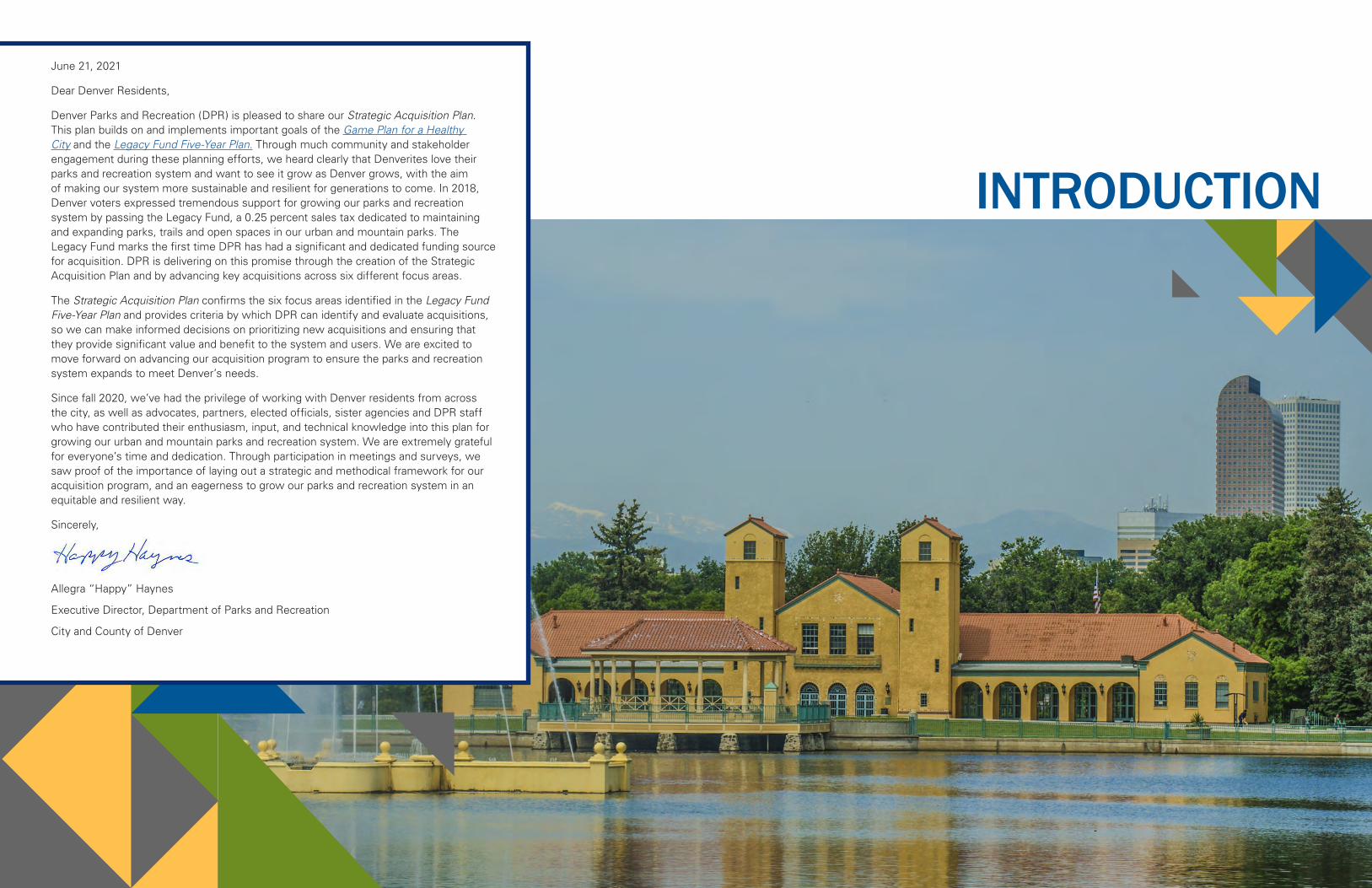
Denver Parks and Recreation (DPR) is pleased to share our Strategic Acquisition Plan. This plan builds on and implements important goals of the Game Plan for a Healthy City and the Legacy Fund Five-Year Plan. Through much community and stakeholder engagement during these planning efforts, we heard clearly that Denverites love their parks and recreation system and want to see it grow as Denver grows, with the aim of making our system more sustainable and resilient for generations to come. In 2018, Denver voters expressed tremendous support for growing our parks and recreation system by passing the Legacy Fund, a 0.25 percent sales tax dedicated to maintaining and expanding parks, trails and open spaces in our urban and mountain parks. The Legacy Fund marks the first time DPR has had a significant and dedicated funding source for acquisition. DPR is delivering on this promise through the creation of the Strategic Acquisition Plan and by advancing key acquisitions across six different focus areas.
The Strategic Acquisition Plan confirms the six focus areas identified in the Legacy Fund Five-Year Plan and provides criteria by which DPR can identify and evaluate acquisitions, so we can make informed decisions on prioritizing new acquisitions and ensuring that they provide significant value and benefit to the system and users. We are excited to move forward on advancing our acquisition program to ensure the parks and recreation system expands to meet Denver’s needs.
Since fall 2020, we’ve had the privilege of working with Denver residents from across the city, as well as advocates, partners, elected officials, sister agencies and DPR staff who have contributed their enthusiasm, input, and technical knowledge into this plan for growing our urban and mountain parks and recreation system. We are extremely grateful for everyone’s time and dedication. Through participation in meetings and surveys, we saw proof of the importance of laying out a strategic and methodical framework for our acquisition program, and an eagerness to grow our parks and recreation system in an equitable and resilient way.
Sincerely,
Allegra “Happy” Haynes
Executive Director, Department of Parks and Recreation
City and County of Denver
2 | Introduction Introduction | 3
A MOVE FORWARDHow We Got HereDenver Parks and Recreation (DPR) has developed a Strategic Acquisition Plan to guide the growth of an equitable, sustainable and resilient parks and recreation system for a healthier Denver. The Strategic Acquisition Plan builds off of and is an implementation tool to realize the Game Plan for a Healthy City and the Legacy Fund Five-Year Plan. The Strategic Acquisition Plan confirms the six focus areas identified in the Legacy Fund Five-Year Plan, which are:
• 10-Minute Walk or Roll
• Mountain Parks
• Facilities
• Resilience, Habitat Restoration and Waterways
• Downtown, High-Density and Growth Areas
• Equity
PurposeThe Strategic Acquisition Plan provides criteria DPR can use to evaluate acquisitions and make informed decisions on prioritizing and balancing growth opportunities across the six focus areas. The plan also provides the means to evaluate how new land opportunities provide value and benefit to the parks and recreation system and users. The plan identifies specific goals that can be used as measures of success associated with each focus area. The plan also identifies a “toolbox” of various strategies DPR can utilize to expand the parks and recreation system.
Process Overview The process for developing the Strategic Acquisition Plan kicked off in the fall of 2020 with engagement and content development. Design Workshop, the consultant, worked hand-in-hand with DPR’s Core Planning Team to engage a robust set of stakeholders over the course of the project. It included technical staff focus groups, meetings with Technical Partners, presentations to the DPR and Division of Real Estate leadership team, and engagement with City Council and the Parks and Recreation Advisory Board.
The process was guided by constant input from the public through public meetings and surveys to collect feedback on the vision, recommendations, and criteria. This engagement effort was critical to developing the final document that will guide decision-making on parks acquisitions in the future.
VISIONThe DPR Strategic Acquisition Plan provides a clear framework
for decision-making that identifies
priorities, describes strategies, and
explains criteria for success associated
with completing and funding future
acquisitions. This framework will ensure
Denver’s urban and mountain parks,
open spaces, and recreation system will
equitably meet the recreational needs
of the entire community while also
ensuring that Denver remains a resilient,
sustainable and healthy city.
LEGACY FUNDThanks to Denver voters who passed the 2018 Ballot Measure 2A: Parks and Open Space Sales Tax (2A funding), a 0.25% sales tax has been dedicated to the improvement and expansion of Denver’s parks and recreation system, accelerating implementation of Game Plan for a Healthy City. This “Legacy Fund” combined with the City General Fund, will create new opportunities to realize the Game Plan’s goals and enhance the legacy of green space and outdoor culture that DPR will leave future generations.
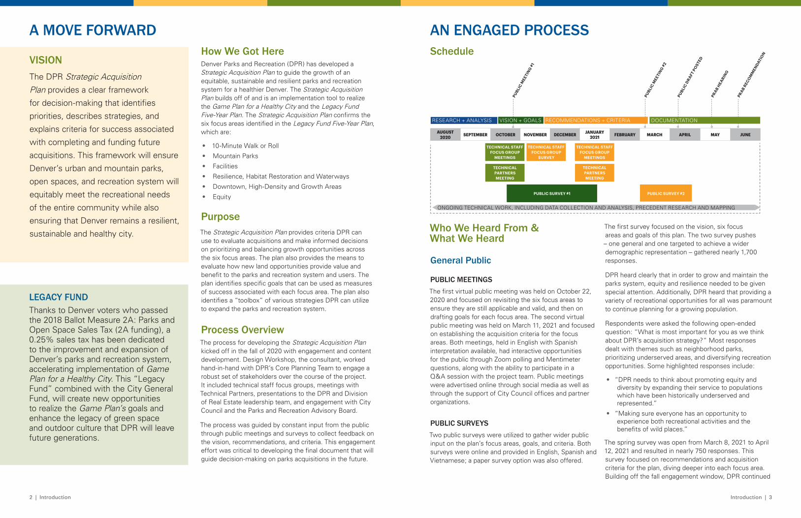
Schedule
ONGOING TECHNICAL WORK, INCLUDING DATA COLLECTION AND ANALYSIS, PRECEDENT RESEARCH AND MAPPING
AUGUST 2020 SEPTEMBER OCTOBER NOVEMBER DECEMBER JANUARY
2021 FEBRUARY MARCH APRIL MAY
RESEARCH + ANALYSIS VISION + GOALS RECOMMENDATIONS + CRITERIA DOCUMENTATION
TECHNICAL STAFF FOCUS GROUP
MEETINGS
TECHNICAL STAFF FOCUS GROUP
MEETINGS
TECHNICAL STAFF FOCUS GROUP
SURVEY
TECHNICAL PARTNERS MEETING
TECHNICAL PARTNERS MEETING
PUBLI
C MEE
TIN
G #1
PUBLI
C MEE
TIN
G #2
PUBLIC SURVEY #1 PUBLIC SURVEY #2
PUBLI
C DRAFT
PO
STED
The first survey focused on the vision, six focus areas and goals of this plan. The two survey pushes – one general and one targeted to achieve a wider demographic representation – gathered nearly 1,700 responses.
DPR heard clearly that in order to grow and maintain the parks system, equity and resilience needed to be given special attention. Additionally, DPR heard that providing a variety of recreational opportunities for all was paramount to continue planning for a growing population.
Respondents were asked the following open-ended question: “What is most important for you as we think about DPR’s acquisition strategy?” Most responses dealt with themes such as neighborhood parks, prioritizing underserved areas, and diversifying recreation opportunities. Some highlighted responses include:
• “DPR needs to think about promoting equity and diversity by expanding their service to populations which have been historically underserved and represented.”
• “Making sure everyone has an opportunity to experience both recreational activities and the benefits of wild places.”
The spring survey was open from March 8, 2021 to April 12, 2021 and resulted in nearly 750 responses. This survey focused on recommendations and acquisition criteria for the plan, diving deeper into each focus area. Building off the fall engagement window, DPR continued
AN ENGAGED PROCESS
PRAB
HEA
RING
Who We Heard From & What We Heard
General Public
PUBLIC MEETINGSThe first virtual public meeting was held on October 22, 2020 and focused on revisiting the six focus areas to ensure they are still applicable and valid, and then on drafting goals for each focus area. The second virtual public meeting was held on March 11, 2021 and focused on establishing the acquisition criteria for the focus areas. Both meetings, held in English with Spanish interpretation available, had interactive opportunities for the public through Zoom polling and Mentimeter questions, along with the ability to participate in a Q&A session with the project team. Public meetings were advertised online through social media as well as through the support of City Council offices and partner organizations.
PUBLIC SURVEYSTwo public surveys were utilized to gather wider public input on the plan’s focus areas, goals, and criteria. Both surveys were online and provided in English, Spanish and Vietnamese; a paper survey option was also offered.
JUNE
PRAB
RECO
MM
ENDATI
ON
4 | Introduction Introduction | 5
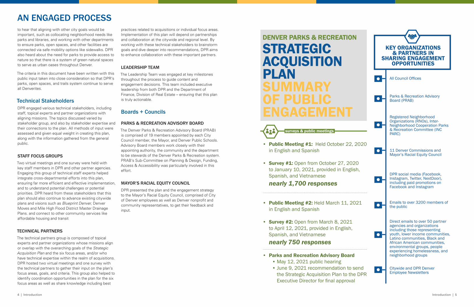
DENVER PARKS & RECREATION
STRATEGIC ACQUISITION PLANSUMMARY OF PUBLIC ENGAGEMENT
• Public Meeting #1: Held October 22, 2020 in English and Spanish
• Survey #1: Open from October 27, 2020 to January 10, 2021, provided in English, Spanish, and Vietnamese nearly 1,700 responses
• Public Meeting #2: Held March 11, 2021 in English and Spanish
• Survey #2: Open from March 8, 2021 to April 12, 2021, provided in English, Spanish, and Vietnamese nearly 750 responses
surveys & public meetings
• Parks and Recreation Advisory Board • May 12, 2021 public hearing• June 9, 2021 recommendation to send
the Strategic Acquisition Plan to the DPR Executive Director for final approval
All Council Offices
Parks & Recreation Advisory Board (PRAB)
Registered Neighborhood Organizations (RNOs), Inter-Neighborhood Cooperation Parks & Recreation Committee (INC PARC)
11 Denver Commissions and Mayor’s Racial Equity Council
DPR social media (Facebook, Instagram, Twitter, NextDoor), including paid promotions on Facebook and Instagram
Emails to over 3200 members of the public
Citywide and DPR Denver Employee Newsletters
KEY ORGANIZATIONS & PARTNERS IN
SHARING ENGAGEMENT OPPORTUNITIES
Direct emails to over 50 partner agencies and organizations including those representing youth, lower income communities, Latino communities, Black and African American communities, environmental groups, people experiencing homelessness, and neighborhood groups
to hear that aligning with other city goals would be important, such as collocating neighborhood needs like parks and libraries, and working with other departments to ensure parks, open spaces, and other facilities are connected via safe mobility options like sidewalks. DPR also heard about the need for parks to provide access to nature so that there is a system of green natural spaces to serve as urban oases throughout Denver.
The criteria in this document have been written with this public input taken into close consideration so that DPR’s parks, open spaces, and trails system continue to serve all Denverites.
Technical StakeholdersDPR engaged various technical stakeholders, including staff, topical experts and partner organizations with aligning missions. The topics discussed varied by stakeholder group, and also by stakeholder expertise and their connections to the plan. All methods of input were assessed and given equal weight in creating this plan, along with the information gathered from the general public.
STAFF FOCUS GROUPSTwo virtual meetings and one survey were held with key staff members in DPR and other partner agencies. Engaging this group of technical staff experts helped integrate cross-departmental efforts into this plan, ensuring far more efficient and effective implementation, and to understand potential challenges or potential priorities. DPR heard from these stakeholders that this plan should also continue to advance existing citywide plans and visions such as Blueprint Denver, Denver Moves and Mile High Flood District Master Drainage Plans. and connect to other community services like affordable housing and transit
TECHNICAL PARTNERSThe technical partners group is composed of topical experts and partner organizations whose missions align or overlap with the overarching goals of the Strategic Acquisition Plan and the six focus areas, and/or who have technical expertise within the realm of acquisitions. DPR hosted two virtual meetings and one survey with the technical partners to gather their input on the plan’s focus areas, goals, and criteria. This group also helped to identify coordination opportunities in the plan for the six focus areas as well as share knowledge including best
practices related to acquisitions or individual focus areas. Implementation of this plan will depend on partnerships and collaboration at the citywide and regional level. By working with these technical stakeholders to brainstorm goals and dive deeper into recommendations, DPR aims to enhance collaboration with these important partners.
LEADERSHIP TEAMThe Leadership Team was engaged at key milestones throughout the process to guide content and engagement decisions. This team included executive leadership from both DPR and the Department of Finance, Division of Real Estate – ensuring that this plan is truly actionable.
Boards + Councils
PARKS & RECREATION ADVISORY BOARDThe Denver Parks & Recreation Advisory Board (PRAB) is comprised of 19 members appointed by each City Council member, the Mayor, and Denver Public Schools. Advisory Board members work closely with their appointing authority, the community and the department to be stewards of the Denver Parks & Recreation system. PRAB’s Sub-Committee on Planning & Design, Funding, Access & Accessibility was particularly involved in this effort.
MAYOR’S RACIAL EQUITY COUNCIL DPR presented the plan and the engagement strategy to the Mayor’s Racial Equity Council, comprised of City of Denver employees as well as Denver nonprofit and community representatives, to get their feedback and input.
AN ENGAGED PROCESS
7
ACQUISITION HISTORY & EXISTING CONDITIONS
8 | Existing Conditions Existing Conditions | 9
INTRODUCING THE FOCUS AREASAcquiring additional land for parks, open spaces and trails is just one of several ways DPR can achieve Game Plan’s goals, albeit an important one. Other methods and opportunities, which are not mutually exclusive to acquisitions, include improving and maintaining existing parks, open spaces, and trails; building and maintaining new parks and trails; restoring and protecting natural features such as waterways, rivers, canals, and streams; and expanding the urban tree cover in parks, parkways, and public right-of-ways. To help guide DPR’s acquisition planning and lay the groundwork for the Strategic Acquisition Plan, focus areas were developed as part of the Legacy Fund Five-Year planning process and confirmed during the engagement for this plan in the fall of 2020. The focus areas include:
• 10-Minute Walk or Roll
• Mountain Parks
• Facilities
• Resilience, Habitat Restoration and Waterways
• Downtown, High-Density and Growth Areas
• Equity
Throughout the course of this plan, DPR will likely encounter acquisition opportunities that may not fall under one of the six focus areas, but that are strategic and critical for ensuring a sustainably managed, accessible and resilient system. These opportunities may include boundary adjustments, inholdings, and other small acquisitions within or adjacent to existing parks.
Why Are These A Focus Now?
10-Minute Walk or Roll (5-Minutes Downtown)• Mayor Michael B. Hancock and DPR have stated
that all residents across the city should be within a 10-minute walk or roll to a park, and within a 5-minute walk or roll to a park in Downtown Denver, in order to increase access to quality parks for all.
• Denver received the National Recreation and Parks Association 10-Minute Walk Grant and this plan is partially funded by that grant effort, helping to fulfill Denver’s grant commitment of creating a Strategic Acquisition Plan.
Mountain Parks• There may be strategic opportunities to acquire lands
for the Mountain Parks system, particularly if those lands contribute to wildlife habitat, recreation, and/or education.
• Through Game Plan engagement, DPR knows Denverites want improved access to the Mountain Parks for all, and increased opportunities for outdoor recreation, environmental education and habitat preservation.
Facilities• New DPR facilities are needed to serve the system,
including land and buildings for maintenance shops, recreation centers, pools and offices.
• Maintenance shops allow DPR staff to efficiently and effectively maintain existing parks, trails, trees and recreation centers.
• DPR is committed to providing a diverse array of recreation opportunities for all residents.
Resilience, Habitat Restoration and Waterways• This focus area includes waterway corridors where
multiple benefits can be achieved, such as bank stabilization, habitat restoration, trail connections and improvements, flood mitigation, and increased access to parks and open space.
• It also includes resilient natural green spaces, such as open spaces with native vegetation that sequesters carbon and supports native pollinators, and tree canopies which help cleanse the air and keep Denver cool in the summer.
Downtown, High-Density and Growth Areas• These areas typically have a lower ratio of park
acreage per capita and continue to see increasing development density and expanded demand on existing parks and public spaces.
• Park expansion in these areas is important to maintain Denver’s goal of having 9 acres of park space per thousand people.
• Parks, open spaces, and trails also help meet the increasing demand for a diversity of recreational, cultural, and ecological activities in areas that attract many residents and visitors.
Equity• The Equity focus area combines various park equity
factors with demographic and socio-economic factors to determine which neighborhoods are most in need of equitable investment.
• DPR acknowledges that certain neighborhoods, and especially communities of color, have been historically underserved, and are in need of equitable access to parks and recreation centers and the various amenities and programs they provide.
• Neighborhoods that have been historically underserved face many competing priorities in order to achieve a high quality of life, such as balancing affordable housing with access to open space. This plan lays out a path to better coordinate with other community-serving uses and providers, such as affordable housing, libraries, and others.
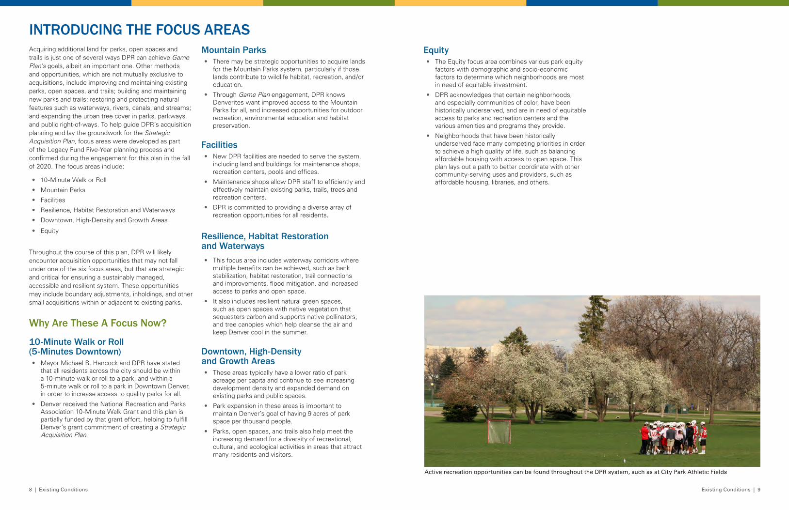
Active recreation opportunities can be found throughout the DPR system, such as at City Park Athletic Fields
10 | Existing Conditions Existing Conditions | 11
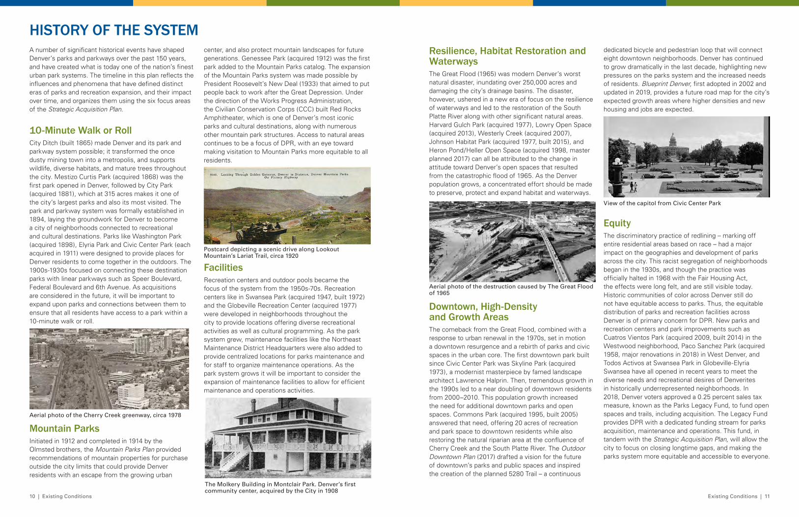
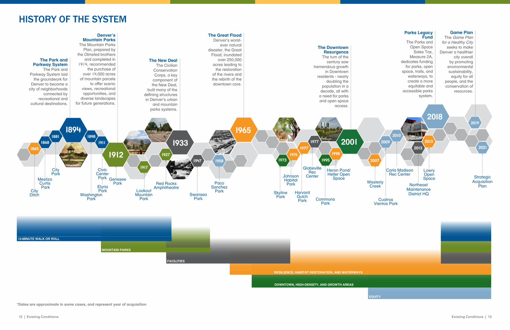
center, and also protect mountain landscapes for future generations. Genessee Park (acquired 1912) was the first park added to the Mountain Parks catalog. The expansion of the Mountain Parks system was made possible by President Roosevelt’s New Deal (1933) that aimed to put people back to work after the Great Depression. Under the direction of the Works Progress Administration, the Civilian Conservation Corps (CCC) built Red Rocks Amphitheater, which is one of Denver’s most iconic parks and cultural destinations, along with numerous other mountain park structures. Access to natural areas continues to be a focus of DPR, with an eye toward making visitation to Mountain Parks more equitable to all residents.
FacilitiesRecreation centers and outdoor pools became the focus of the system from the 1950s-70s. Recreation centers like in Swansea Park (acquired 1947, built 1972)and the Globeville Recreation Center (acquired 1977) were developed in neighborhoods throughout the city to provide locations offering diverse recreational activities as well as cultural programming. As the park system grew, maintenance facilities like the Northeast Maintenance District Headquarters were also added to provide centralized locations for parks maintenance and for staff to organize maintenance operations. As the park system grows it will be important to consider the expansion of maintenance facilities to allow for efficient maintenance and operations activities.
A number of significant historical events have shaped Denver’s parks and parkways over the past 150 years, and have created what is today one of the nation’s finest urban park systems. The timeline in this plan reflects the influences and phenomena that have defined distinct eras of parks and recreation expansion, and their impact over time, and organizes them using the six focus areas of the Strategic Acquisition Plan.
10-Minute Walk or RollCity Ditch (built 1865) made Denver and its park and parkway system possible; it transformed the once dusty mining town into a metropolis, and supports wildlife, diverse habitats, and mature trees throughout the city. Mestizo Curtis Park (acquired 1868) was the first park opened in Denver, followed by City Park (acquired 1881), which at 315 acres makes it one of the city’s largest parks and also its most visited. The park and parkway system was formally established in 1894, laying the groundwork for Denver to become a city of neighborhoods connected to recreational and cultural destinations. Parks like Washington Park (acquired 1898), Elyria Park and Civic Center Park (each acquired in 1911) were designed to provide places for Denver residents to come together in the outdoors. The 1900s-1930s focused on connecting these destination parks with linear parkways such as Speer Boulevard, Federal Boulevard and 6th Avenue. As acquisitions are considered in the future, it will be important to expand upon parks and connections between them to ensure that all residents have access to a park within a 10-minute walk or roll.
Mountain ParksInitiated in 1912 and completed in 1914 by the Olmsted brothers, the Mountain Parks Plan provided recommendations of mountain properties for purchase outside the city limits that could provide Denver residents with an escape from the growing urban
HISTORY OF THE SYSTEM
Aerial photo of the Cherry Creek greenway, circa 1978
The Molkery Building in Montclair Park. Denver’s first community center, acquired by the City in 1908
Postcard depicting a scenic drive along Lookout Mountain’s Lariat Trail, circa 1920
dedicated bicycle and pedestrian loop that will connect eight downtown neighborhoods. Denver has continued to grow dramatically in the last decade, highlighting new pressures on the parks system and the increased needs of residents. Blueprint Denver, first adopted in 2002 and updated in 2019, provides a future road map for the city’s expected growth areas where higher densities and new housing and jobs are expected.
EquityThe discriminatory practice of redlining – marking off entire residential areas based on race – had a major impact on the geographies and development of parks across the city. This racist segregation of neighborhoods began in the 1930s, and though the practice was officially halted in 1968 with the Fair Housing Act, the effects were long felt, and are still visible today. Historic communities of color across Denver still do not have equitable access to parks. Thus, the equitable distribution of parks and recreation facilities across Denver is of primary concern for DPR. New parks and recreation centers and park improvements such as Cuatros Vientos Park (acquired 2009, built 2014) in the Westwood neighborhood, Paco Sanchez Park (acquired 1958, major renovations in 2018) in West Denver, and Todos Activos at Swansea Park in Globeville-Elyria Swansea have all opened in recent years to meet the diverse needs and recreational desires of Denverites in historically underrepresented neighborhoods. In 2018, Denver voters approved a 0.25 percent sales tax measure, known as the Parks Legacy Fund, to fund open spaces and trails, including acquisition. The Legacy Fund provides DPR with a dedicated funding stream for parks acquisition, maintenance and operations. This fund, in tandem with the Strategic Acquisition Plan, will allow the city to focus on closing longtime gaps, and making the parks system more equitable and accessible to everyone.
Resilience, Habitat Restoration and WaterwaysThe Great Flood (1965) was modern Denver’s worst natural disaster, inundating over 250,000 acres and damaging the city’s drainage basins. The disaster, however, ushered in a new era of focus on the resilience of waterways and led to the restoration of the South Platte River along with other significant natural areas. Harvard Gulch Park (acquired 1977), Lowry Open Space (acquired 2013), Westerly Creek (acquired 2007), Johnson Habitat Park (acquired 1977, built 2015), and Heron Pond/Heller Open Space (acquired 1998, master planned 2017) can all be attributed to the change in attitude toward Denver’s open spaces that resulted from the catastrophic flood of 1965. As the Denver population grows, a concentrated effort should be made to preserve, protect and expand habitat and waterways.
Downtown, High-Density and Growth AreasThe comeback from the Great Flood, combined with a response to urban renewal in the 1970s, set in motion a downtown resurgence and a rebirth of parks and civic spaces in the urban core. The first downtown park built since Civic Center Park was Skyline Park (acquired 1973), a modernist masterpiece by famed landscape architect Lawrence Halprin. Then, tremendous growth in the 1990s led to a near doubling of downtown residents from 2000–2010. This population growth increased the need for additional downtown parks and open spaces. Commons Park (acquired 1995, built 2005) answered that need, offering 20 acres of recreation and park space to downtown residents while also restoring the natural riparian area at the confluence of Cherry Creek and the South Platte River. The Outdoor Downtown Plan (2017) drafted a vision for the future of downtown’s parks and public spaces and inspired the creation of the planned 5280 Trail – a continuous
Aerial photo of the destruction caused by The Great Flood of 1965
View of the capitol from Civic Center Park
12 | Existing Conditions Existing Conditions | 13
HISTORY OF THE SYSTEM
1894
1865
18981911
19121917
1927
1965
1973
1977
2013
2007
2018
19951976
19331998
2021
2010
2019
18681881
1947 1958
2001 20092013
1977
Genesee Park
Civic Center Park
Lookout Mountain
Park
City Ditch
Mestizo Curtis Park
City Park
Washington Park
Paco Sanchez
Park
Carla Madison Rec Center
Commons Park
Skyline Park
Elyria Park
SwanseaPark
Harvard Gulch Park
LowryOpen Space
Westerly Creek
Johnson Habitat ParkRed Rocks
Amphitheatre
Heron Pond/Heller Open
Space
GlobevilleRec
Center
Cuatros Vientos Park
Northeast MaintenanceDistrict HQ
Strategic Acquisition
Plan
The Park and Parkway System
The Park and Parkway System laid
the groundwork for Denver to become a
city of neighborhoods connected by
recreational and cultural destinations.
Denver’s Mountain Parks
The Mountain Parks Plan, prepared by
the Olmsted brothers and completed in
1914, recommended the purchase of
over 14,000 acres of mountain parcels
to offer scenic views, recreational opportunities, and
diverse landscapes for future generations.
The New DealThe Civilian
Conservation Corps, a key
component of the New Deal,
built many of the defining structures in Denver’s urban
and mountain parks systems.
The Great FloodDenver’s worst-
ever natural disaster, the Great
Flood, inundated over 250,000
acres leading to the restoration
of the rivers and the rebirth of the downtown core.
Parks Legacy Fund
The Parks and Open Space
Sales Tax, Measure 2A,
dedicates funding for parks, open
space, trails, and waterways, to create a more equitable and
accessible parks system.
Game PlanThe Game Plan
for a Healthy City seeks to make
Denver a healthier city overall
by promoting environmental sustainability,
equity for all people, and the conservation of
resources.
RESILIENCE, HABITAT RESTORATION, AND WATERWAYS
10-MINUTE WALK OR ROLL
MOUNTAIN PARKS
FACILITIES
EQUITY
DOWNTOWN, HIGH-DENSITY, AND GROWTH AREAS
The Downtown Resurgence
The turn of the century saw
tremendous growth in Downtown
residents - nearly doubling the
population in a decade, all with
a need for parks and open space
access.
*Dates are approximate in some cases, and represent year of acquisition
14 | Existing Conditions Existing Conditions | 15
CONTEXT OF DENVER TODAYChallenges and Opportunities for Growing the Parks and Recreation System
Population Growth Like many U.S. cities, there has been significant reinvestment and movement back to the urban core of Denver. Large regional investments in the FasTracks transit system, investments in downtown Denver, and general demographic shifts which favor urban living have reenergized the city.
Denver’s population has grown significantly, particularly in the last decade. The city’s population started to show significant increases in the late 2000s. In 2000, the population was about 550,000 persons. In twenty years, Denver has grown by one-third of this 2000 population. Between 2000 and 2010, population growth averaged less than 1 percent per year. Between 2010 and 2019, the average annual growth rate increased significantly to 2.2 percent. The city’s estimated population in 2019 was 727,000 persons, according to the U.S. Census American Community Survey.
Planning and Zoning In 2002 the original Blueprint Denver provided the city’s first comprehensive approach to managing growth and development. Through the plan, Denver directed much of its development to “areas of change.” These areas included the downtown and several downtown-adjacent neighborhoods, large undeveloped areas, transit station areas, and some major corridors.
In 2010, the city completely overhauled its zoning code, with the intent of simplifying the code and modernizing it by making it context-sensitive and form-based. The adoption of the new zoning code in 2010 achieved many key goals from 2002 Blueprint Denver.
In 2019, the city updated a series of citywide plans including the Comprehensive Plan, its Land Use and Transportation Plan, Blueprint Denver, as well as its Parks and Recreation Plan, Game Plan for a Healthy City. The updated Blueprint Denver replaced the areas of change approach with a more detailed and nuanced “growth strategy” that emphasizes that all parts of the city will experience some amount of change, while most future growth will be directed to key mixed use centers and corridors.
Denver Parks and Recreation’s Game Plan for a Healthy City closely examines Denver’s growth and outlines areas of the city which are underserved, many of which have been historically underserved, not just because of recent growth. Game Plan calls for closing the 10-minute walk or roll access gap and exploring opportunities to expand the parks and recreation system in areas of most need.
Over the past three decades, many of the city’s largest parks additions (greater than 20 acres) have primarily been concentrated in Denver’s larger redevelopment areas, including Green Valley Ranch, Central Park, Lowry and the Riverfront Park area. During that same time period, DPR has made large acquisitions such as Heron Pond-Carpio Sanguinette Park as part of its effort to grow and expand the city’s parks and recreation system in historically underserved communities.
Land Values One of the challenges as Denver builds out is the increasing price for land, particularly where the city has seen the most recent higher-density developments. Land prices vary significantly throughout the city depending on the underlying zoning, proximity to downtown, rail transit and a variety of market factors. Considering Denver’s highly competitive real estate market, DPR will face stiff competition from the private sector as it works to grow and expand the parks and recreation system.
In 2014, the higher priced land areas were concentrated in the Union Station, the Central Business District and Cherry Creek neighborhoods, and the neighborhoods immediately adjacent to them. As of 2020, land values
have increased more broadly across the city. Much of central Denver is valued at over $75 per square foot. The northwest neighborhoods, in particular, have seen large increases in values during the last five years.
Involuntary Displacement Decades of research have proven that historically marginalized neighborhoods are negatively impacted by land-use decisions and are often located near polluting facilities such as landfills, highways, and refineries. Not only are residents exposed to environmental harms, but they also lack access to green amenities such as parks, bike lanes, and fresh food.1 Research recognizes that there are significant health benefits associated with these types of amenities, and now greater efforts are being taken to ensure that they are equitably distributed.2
DPR recognizes the past injustices that have resulted in certain neighborhoods having less historic investment that directly serves and benefits the local community. These historic injustices often occurred in communities of color and in lower-income neighborhoods and the impacts are still evident today. DPR is committed to making parks and recreation investments in neighborhoods that have been historically underserved, with the intent of benefiting residents who live there today. Parks, open spaces, trees and opportunities to recreate, play, celebrate culture, and connect with friends and neighbors, are critical to creating healthy communities with a high quality of life. All Denver residents should have easy access to these spaces and amenities. As part of the Strategic Acquisition Plan’s
equity lens and Equity Focus Area, DPR will work to expand the parks and recreation system in high equity-needs neighborhoods.
DPR is sensitive to neighborhood concerns about involuntary displacement, which may occur when property values or rents rise and residents or businesses are forced to relocate to neighborhoods where real estate is less costly. As part of the Equity Focus Area of the Strategic Acquisition Plan, DPR will be seeking out opportunities to create parks and open spaces in coordination with partners, such as affordable housing providers, and other community-serving uses such as schools, libraries, and other uses that provides community benefits. DPR also coordinates with other city departments including the Department of Public Health & Environment (DDPHE), the Department of Transportation & Infrastructure (DOTI), the Department of Housing Stability (HOST), and the Department of Economic Development & Opportunity’s Neighborhood Equity & Stabilization (NEST) team, which offer a variety of anti-displacement tools.
1 Brulle, Robert J., and David N. Pellow. “Environmental justice: human health and environmental inequalities.” Annu. Rev. Public Health 27 (2006): 103-124; Bullard, Robert D. Dumping in Dixie: Race, class, and environmental quality. Avalon Publishing- (Westview Press), 2008; Rigolon, Alessandro, and Jeremy Németh. “We’re not in the business of housing:” Environmental gentrification and the nonprofitization of green infrastructure projects.” Cities 81 (2018): 71-80; Rigolon, Alessandro, and Jeremy Németh. “What shapes uneven access to urban amenities? Thick injustice and the legacy of racial discrimination in Denver’s parks.” Journal of Planning Education and Research (2018): 0739456X18789251.
2 Gies, Erica. “The health benefits of parks.” The Trust for Public Land (2006): 1-24.
INVOLUNTARY DISPLACEMENTWhen property values and/or rents in an area rise, and residents and/or businesses are forced to relocate to neighborhoods where real estate is less costly – Denver’s Comprehensive Plan 2040, p. 72.
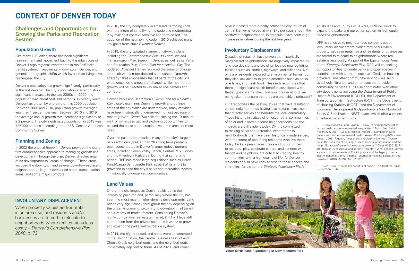
Youth participate in gardening in New Freedom Park
17 17
ACQUISITION CRITERIA
18 | Acquisition Criteria Acquisition Criteria | 19
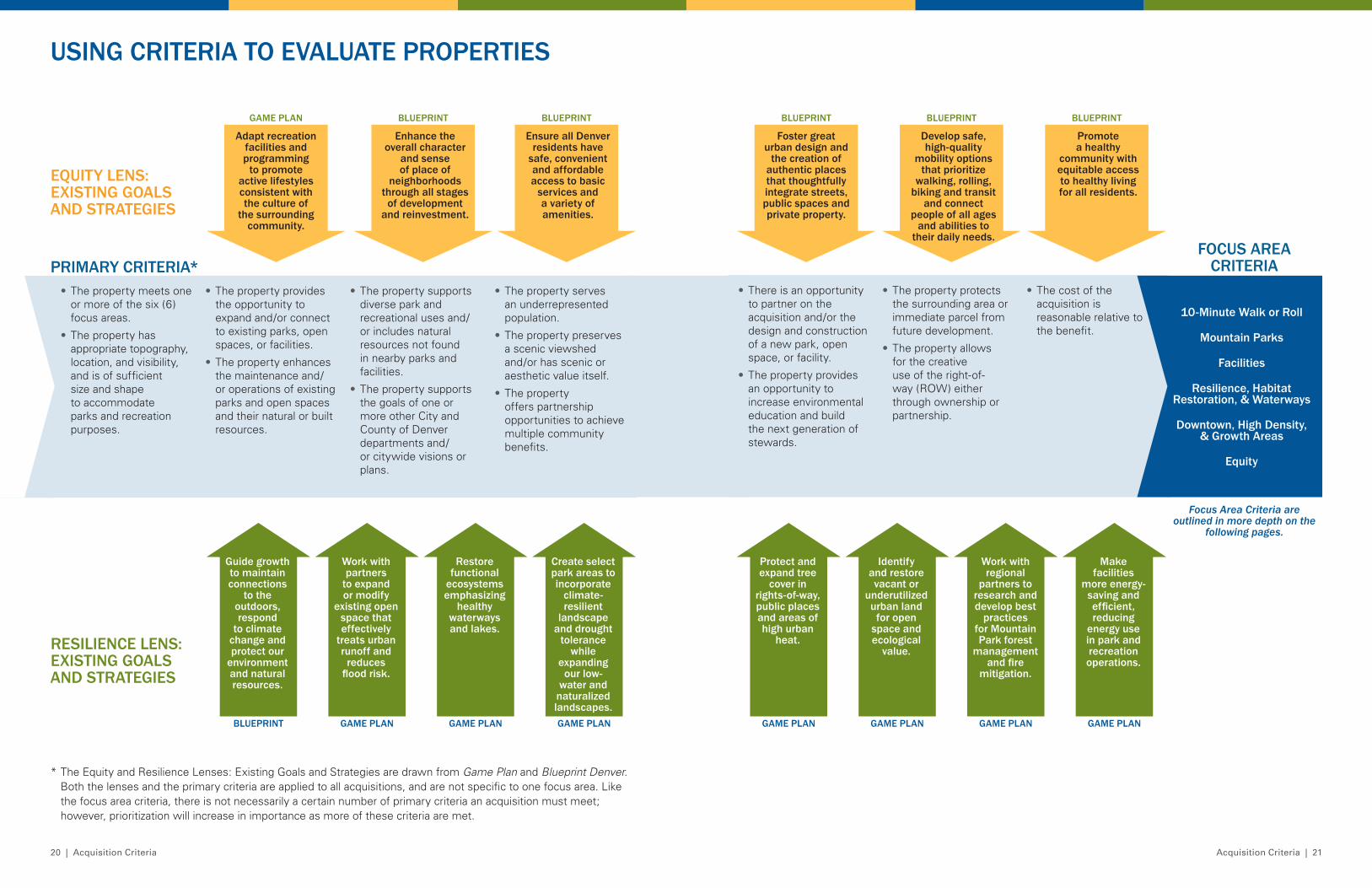
USING CRITERIA TO EVALUATE PROPERTIESUsing the Criteria as a GuideJust like a fingerprint, no two properties or pieces of land are alike. Moreover, although the Parks Legacy Fund will be the primary source of funding for acquisitions of new parks, open spaces and trails, it is not an infinite source of funds. DPR will need to be thoughtful, deliberate, and strategic in making decisions on potential acquisitions. The criteria outlined in this plan will help DPR do just that and guide the department in identifying, evaluating, and ultimately pursuing potential acquisitions.
PLAN ALIGNMENTSpecific attention will be given to acquisitions that align with existing citywide plans and visions, as mentioned in the primary criteria. These plans include, but are not limited to:
• Comprehensive Plan 2040 • Blueprint Denver: A Blueprint for an
Inclusive City• Game Plan for a Healthy City• Denver Moves: Pedestrians and Trails• Denver Mountain Parks Master Plan• Denver Parks & Recreation Legacy Fund
Five-Year Plan 2020-2024• The Outdoor Downtown Plan• The Neighborhood Planning Initiative• Expanding Affordable Housing Plan• Department of Housing Stability 2021 Action
Plan• Arts and Venues Master Plan• Urban Forestry Plan• City and County of Denver Hazard
Mitigation Plan• Resiliency Master Plan• Outdoor Adventure and Alternative Sports
Master Plan• Metro Denver Nature Alliance Regional
Vision• One Water Plan• Highline Canal Vision• Mile High Flood District Master
Drainage Plans
• Adopted corridor plans
• Regional open space master plans
Using the following primary criteria and focus area criteria as a guide, DPR and Division of Real Estate staff will evaluate potential acquisitions to ensure they meet focus area and departmental goals and metrics, needs and visions, and consider partnerships, citywide efforts, and other community benefits. As part of, and in addition to, applying the evaluation criteria to potential acquisitions, DPR will also make site visits for on-the-ground analysis and perform a thorough review using geographic information systems (GIS). GIS provides a system for evaluating land and property, understanding current conditions, and forecasting future scenarios and impacts. Recommendations on specific potential acquisition projects will consider the value proposition of all potential acquisitions, in terms of cost versus benefit, and will ultimately be made by DPR’s Executive Leadership.
As part of its evaluation process, DPR coordinates with other city agencies and departments including the Budget and Management Office and its Capital Planning Programming division, as well as the City Attorney’s Office. This coordination helps to ensure that when planning for acquisitions DPR is considering future operations and maintenance costs, including potential budget expansions and immediate capital and operating improvement costs. Immediate improvement costs may include site stabilization and security, restoration and resource protection, and demolition. This post-acquisition planning is critical for integrating a new acquisition into the DPR system and stabilizing it for future master planning and capital investment.
DPR is developing a Standard Operating Procedure (SOP) for Parks and Recreation staff to outline the process and procedures for identifying, evaluating and acquiring real property for the department.
Equity & Resilience as LensesRecent planning efforts in Denver, including Blueprint Denver, Game Plan, and various neighborhood plans have been generated through a deliberate attempt to authentically engage communities and reach those who have traditionally been left out of conversations about the future of the city. During this process, two themes stood out as important to stakeholders across Denver – equity and resilience. Building on these previous plans and feedback received during the fall 2020 community engagement, this Strategic Acquisition Plan emphasizes both equity and resilience as lenses through which potential acquisitions should be considered. The parks and recreation system plays an important role in the
equitable access to services and opportunities that belong to all Denverites. Our open spaces can also ensure a resilient future for our waterways, biodiversity, and health of our residents.
The diagram on pages 20-21 shows how existing goals and strategies from plans like Game Plan and Blueprint Denver will be used as lenses for potential acquisitions. Along with the primary criteria, these goals and strategies will be used to evaluate each potential acquisition on how well they align with the focus areas, and how they are advancing existing citywide plans.
Focus Area CriteriaThe next section describes criteria for each focus area, which are the qualities that potential acquisitions will be measured against. The various criteria are intended to help DPR evaluate if a potential acquisition will be a meaningful and valuable addition to the parks and recreation system. There is not necessarily a certain number of criteria an acquisition must meet in order to advance, rather the criteria allow DPR to evaluate the benefit the acquisition might bring to the system.
The goals for each focus area were developed through meaningful dialogue with the public and technical stakeholders. These will guide the plan’s effort and are the aim of the plan’s success.
Visualizing the Focus AreasMaps are powerful representations that reveal spatial patterns and processes of social and environmental phenomena. It is essential to build maps so they tell a story that is inclusive and transparent. Maps within a plan document are also a static picture. The data shown here will change over time, impacting the boundaries, inventory and analysis. DPR will continue to update mapping for the six focus areas over time in accordance with the implementation of this plan.
EQUITYEquity is when everyone, regardless of who they are or where they come from, has the opportunity to thrive. Where there is equity, a person’s identity does not determine their outcome. Equitable, inclusive communities are places of value that provide access to resources and opportunities for all people to improve the quality of their life. As a city, we advance equity by serving individuals, families and communities in a manner that reduces or eliminates persistent institutional biases and barriers based on race, ability, gender identity and sexual orientation, age and other factors. – Denver’s Comprehensive Plan 2040, p. 31
RESILIENCEThe ability of communities to rebound, positively adapt to, or thrive amidst changing conditions or challenges—including human-caused and natural disasters—and to maintain quality of life, healthy growth, durable systems, economic vitality, and conservation of resources for present and future generations. – State of Colorado, Colorado Resiliency Office
20 | Acquisition Criteria Acquisition Criteria | 21
EQUITY LENS: EXISTING GOALS AND STRATEGIES
RESILIENCE LENS: EXISTING GOALS AND STRATEGIES
PRIMARY CRITERIA*FOCUS AREA
CRITERIA
Foster great urban design and
the creation of authentic places that thoughtfully integrate streets, public spaces and private property .
Adapt recreation facilities and programming
to promote active lifestyles consistent with the culture of
the surrounding community .
GAME PLAN BLUEPRINT BLUEPRINT BLUEPRINT BLUEPRINT BLUEPRINT
Develop safe, high-quality
mobility options that prioritize
walking, rolling, biking and transit
and connect people of all ages
and abilities to their daily needs .
Promote a healthy
community with equitable access to healthy living for all residents .
Enhance the overall character
and sense of place of
neighborhoods through all stages
of development and reinvestment .
Ensure all Denver residents have
safe, convenient and affordable access to basic
services and a variety of amenities .
• The property meets one or more of the six (6) focus areas.
• The property has appropriate topography, location, and visibility, and is of sufficient size and shape to accommodate parks and recreation purposes.
• The property provides the opportunity to expand and/or connect to existing parks, open spaces, or facilities.
• The property enhances the maintenance and/or operations of existing parks and open spaces and their natural or built resources.
• The property supports diverse park and recreational uses and/or includes natural resources not found in nearby parks and facilities.
• The property supports the goals of one or more other City and County of Denver departments and/or citywide visions or plans.
• The property serves an underrepresented population.
• The property preserves a scenic viewshed and/or has scenic or aesthetic value itself.
• The property offers partnership opportunities to achieve multiple community benefits.
• There is an opportunity to partner on the acquisition and/or the design and construction of a new park, open space, or facility.
• The property provides an opportunity to increase environmental education and build the next generation of stewards.
• The property protects the surrounding area or immediate parcel from future development.
• The property allows for the creative use of the right-of-way (ROW) either through ownership or partnership.
• The cost of the acquisition is reasonable relative to the benefit.
BLUEPRINT GAME PLAN GAME PLAN GAME PLAN GAME PLAN GAME PLAN GAME PLAN GAME PLAN
Protect and expand tree
cover in rights-of-way, public places and areas of high urban
heat .
Guide growth to maintain connections
to the outdoors, respond
to climate change and protect our
environment and natural resources .
Identify and restore vacant or
underutilized urban land
for open space and ecological
value .
Work with partners
to expand or modify
existing open space that effectively
treats urban runoff and
reduces flood risk.
Work with regional
partners to research and develop best
practices for Mountain Park forest
management and fire
mitigation .
Restore functional
ecosystems emphasizing
healthy waterways and lakes .
Make facilities
more energy-saving and efficient, reducing
energy use in park and recreation operations .
Create select park areas to incorporate
climate-resilient
landscape and drought
tolerance while
expanding our low-
water and naturalized landscapes .
10-Minute Walk or Roll
Mountain Parks
Facilities
Resilience, Habitat Restoration, & Waterways
Downtown, High Density, & Growth Areas
Equity
USING CRITERIA TO EVALUATE PROPERTIES
Focus Area Criteria are outlined in more depth on the
following pages.
* The Equity and Resilience Lenses: Existing Goals and Strategies are drawn from Game Plan and Blueprint Denver. Both the lenses and the primary criteria are applied to all acquisitions, and are not specific to one focus area. Like the focus area criteria, there is not necessarily a certain number of primary criteria an acquisition must meet; however, prioritization will increase in importance as more of these criteria are met.
22 | Acquisition Criteria Acquisition Criteria | 23
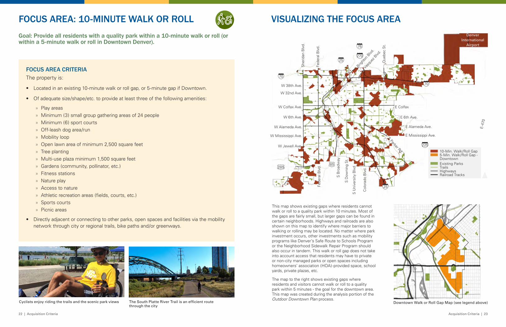
Goal: Provide all residents with a quality park within a 10-minute walk or roll (or within a 5-minute walk or roll in Downtown Denver) .
FOCUS AREA: 10-MINUTE WALK OR ROLL
FOCUS AREA CRITERIAThe property is:
• Located in an existing 10-minute walk or roll gap, or 5-minute gap if Downtown.
• Of adequate size/shape/etc. to provide at least three of the following amenities:
» Play areas » Minimum (3) small group gathering areas of 24 people » Minimum (6) sport courts » Off-leash dog area/run » Mobility loop » Open lawn area of minimum 2,500 square feet » Tree planting » Multi-use plaza minimum 1,500 square feet » Gardens (community, pollinator, etc.) » Fitness stations » Nature play » Access to nature » Athletic recreation areas (fields, courts, etc.) » Sports courts » Picnic areas
• Directly adjacent or connecting to other parks, open spaces and facilities via the mobility network through city or regional trails, bike paths and/or greenways.
Cyclists enjoy riding the trails and the scenic park views The South Platte River Trail is an efficient route through the city
VISUALIZING THE FOCUS AREA
This map shows existing gaps where residents cannot walk or roll to a quality park within 10 minutes. Most of the gaps are fairly small, but larger gaps can be found in certain neighborhoods. Highways and railroads are also shown on this map to identify where major barriers to walking or rolling may be located. No matter where park investment occurs, other investments such as mobility programs like Denver’s Safe Route to Schools Program or the Neighborhood Sidewalk Repair Program should also occur in tandem. This walk or roll gap does not take into account access that residents may have to private or non-city managed parks or open spaces including homeowners’ association (HOA)-provided space, school yards, private plazas, etc.
The map to the right shows existing gaps where residents and visitors cannot walk or roll to a quality park within 5 minutes - the goal for the downtown area. This map was created during the analysis portion of the Outdoor Downtown Plan process.
W Colfax Ave.
W 6th Ave.
W Alameda Ave.
Fede
ral B
lvd.
Col
orad
o B
lvd.
Bright
on B
lvd.
Vasq
uez B
lvd.
E Colfax
E 6th Ave.S Parker Rd.
270
25
70
76
225
28585
70
25
E-4
70
E Alameda Ave.
E Mississippi Ave.W Mississippi Ave.
S B
road
way
S D
owni
ng S
t.
S U
nive
rsity
Blv
d.
W Jewell Ave.
W 38th Ave.
W 32nd Ave.
She
ridan
Blv
d.
Fede
ral B
lvd.
Que
bec
St.
Denver International
Airport
10-Min. Walk/Roll Gap5-Min. Walk/Roll Gap - Downtown
TrailsHighwaysRailroad Tracks
Existing Parks
Downtown Walk or Roll Gap Map (see legend above)
10 Minute Walk or Roll
Resilience
Equity
Facilities
Downtown and High Density
Mountain Parks
24 | Acquisition Criteria Acquisition Criteria | 25
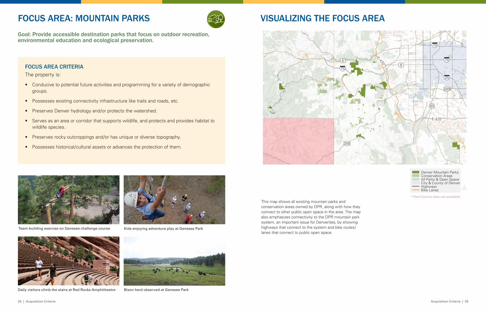
Goal: Provide accessible destination parks that focus on outdoor recreation, environmental education and ecological preservation .
VISUALIZING THE FOCUS AREAFOCUS AREA: MOUNTAIN PARKS
FOCUS AREA CRITERIAThe property is:
• Conducive to potential future activities and programming for a variety of demographic groups.
• Possesses existing connectivity infrastructure like trails and roads, etc.
• Preserves Denver hydrology and/or protects the watershed.
• Serves as an area or corridor that supports wildlife, and protects and provides habitat to wildlife species.
• Preserves rocky outcroppings and/or has unique or diverse topography.
• Possesses historical/cultural assets or advances the protection of them.
Team-building exercise on Genesee challenge course
Daily visitors climb the stairs at Red Rocks Amphitheatre Bison herd observed at Genesee Park
Kids enjoying adventure play at Genesee Park
This map shows all existing mountain parks and conservation areas owned by DPR, along with how they connect to other public open space in the area. The map also emphasizes connectivity to the DPR mountain park system, an important issue for Denverites, by showing highways that connect to the system and bike routes/lanes that connect to public open space.
Denver Mountain ParksConservation AreasAll Parks & Open Space
HighwaysBike Lanes
25
285
85
706
70
285
6
E-470
E-470
70
10 Minute Walk or Roll
Resilience
Equity
Facilities
Downtown and High Density
Mountain Parks
City & County of Denver
* Park County data not available
26 | Acquisition Criteria Acquisition Criteria | 27
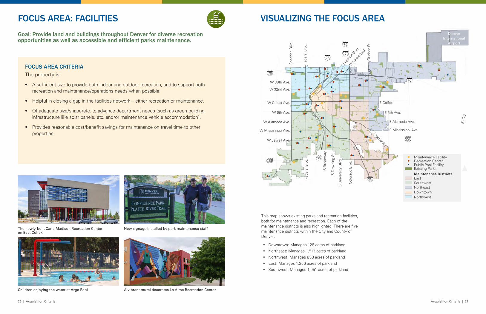
VISUALIZING THE FOCUS AREAGoal: Provide land and buildings throughout Denver for diverse recreation opportunities as well as accessible and efficient parks maintenance .
FOCUS AREA: FACILITIES
FOCUS AREA CRITERIAThe property is:
• A sufficient size to provide both indoor and outdoor recreation, and to support both recreation and maintenance/operations needs when possible.
• Helpful in closing a gap in the facilities network – either recreation or maintenance.
• Of adequate size/shape/etc. to advance department needs (such as green building infrastructure like solar panels, etc. and/or maintenance vehicle accommodation).
• Provides reasonable cost/benefit savings for maintenance on travel time to other properties.
This map shows existing parks and recreation facilities, both for maintenance and recreation. Each of the maintenance districts is also highlighted. There are five maintenance districts within the City and County of Denver.
• Downtown: Manages 128 acres of parkland
• Northeast: Manages 1,513 acres of parkland
• Northwest: Manages 853 acres of parkland
• East: Manages 1,256 acres of parkland
• Southwest: Manages 1,051 acres of parkland
Children enjoying the water at Argo Pool
The newly-built Carla Madison Recreation Center on East Colfax
A vibrant mural decorates La Alma Recreation Center
New signage installed by park maintenance staff
Maintenance Facility
Public Pool FacilityRecreation Center
Existing Parks
EastSouthwest Northeast DowntownNorthwest
Maintenance Districts
W Colfax Ave.
W 6th Ave.
W Alameda Ave.
Fede
ral B
lvd.
Col
orad
o B
lvd.
Bright
on B
lvd.
Vasq
uez B
lvd.
E Colfax
E 6th Ave.S Parker Rd.
270
25
70
76
225
28585
70
25
E-4
70
E Alameda Ave.
E Mississippi Ave.W Mississippi Ave.
S B
road
way
S D
owni
ng S
t.
S U
nive
rsity
Blv
d.
W Jewell Ave.
W 38th Ave.
W 32nd Ave.
She
ridan
Blv
d.
Fede
ral B
lvd.
Que
bec
St.
Denver International
Airport
10 Minute Walk or Roll
Resilience
Equity
Facilities
Downtown and High Density
Mountain Parks
28 | Acquisition Criteria Acquisition Criteria | 29
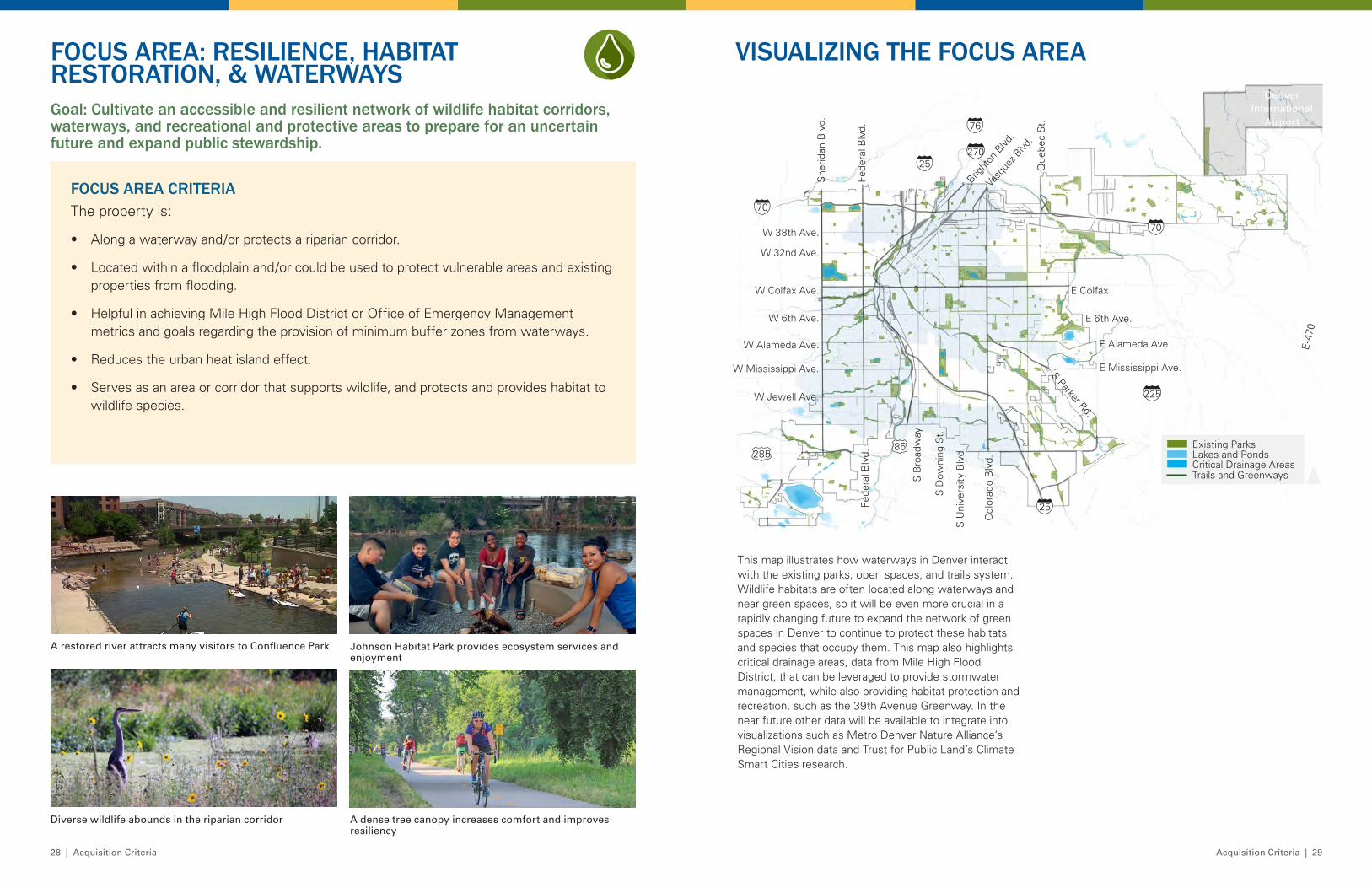
Goal: Cultivate an accessible and resilient network of wildlife habitat corridors, waterways, and recreational and protective areas to prepare for an uncertain future and expand public stewardship .
FOCUS AREA: RESILIENCE, HABITAT RESTORATION, & WATERWAYS
VISUALIZING THE FOCUS AREA
FOCUS AREA CRITERIAThe property is:
• Along a waterway and/or protects a riparian corridor.
• Located within a floodplain and/or could be used to protect vulnerable areas and existing properties from flooding.
• Helpful in achieving Mile High Flood District or Office of Emergency Management metrics and goals regarding the provision of minimum buffer zones from waterways.
• Reduces the urban heat island effect.
• Serves as an area or corridor that supports wildlife, and protects and provides habitat to wildlife species.
A restored river attracts many visitors to Confluence Park
Diverse wildlife abounds in the riparian corridor A dense tree canopy increases comfort and improves resiliency
Johnson Habitat Park provides ecosystem services and enjoyment
W Colfax Ave.
W 6th Ave.
W Alameda Ave.
Fede
ral B
lvd.
Col
orad
o B
lvd.
Bright
on B
lvd.
Vasq
uez B
lvd.
E Colfax
E 6th Ave.S Parker Rd.
270
25
70
76
225
28585
70
25
E-4
70
E Alameda Ave.
E Mississippi Ave.W Mississippi Ave.
S B
road
way
S D
owni
ng S
t.
S U
nive
rsity
Blv
d.
W Jewell Ave.
W 38th Ave.
W 32nd Ave.
She
ridan
Blv
d.
Fede
ral B
lvd.
Que
bec
St.
Existing Parks
Trails and Greenways
Lakes and PondsCritical Drainage Areas
Denver International
Airport
This map illustrates how waterways in Denver interact with the existing parks, open spaces, and trails system. Wildlife habitats are often located along waterways and near green spaces, so it will be even more crucial in a rapidly changing future to expand the network of green spaces in Denver to continue to protect these habitats and species that occupy them. This map also highlights critical drainage areas, data from Mile High Flood District, that can be leveraged to provide stormwater management, while also providing habitat protection and recreation, such as the 39th Avenue Greenway. In the near future other data will be available to integrate into visualizations such as Metro Denver Nature Alliance’s Regional Vision data and Trust for Public Land’s Climate Smart Cities research.
10 Minute Walk or Roll
Resilience
Equity
Facilities
Downtown and High Density
Mountain Parks
30 | Acquisition Criteria Acquisition Criteria | 31
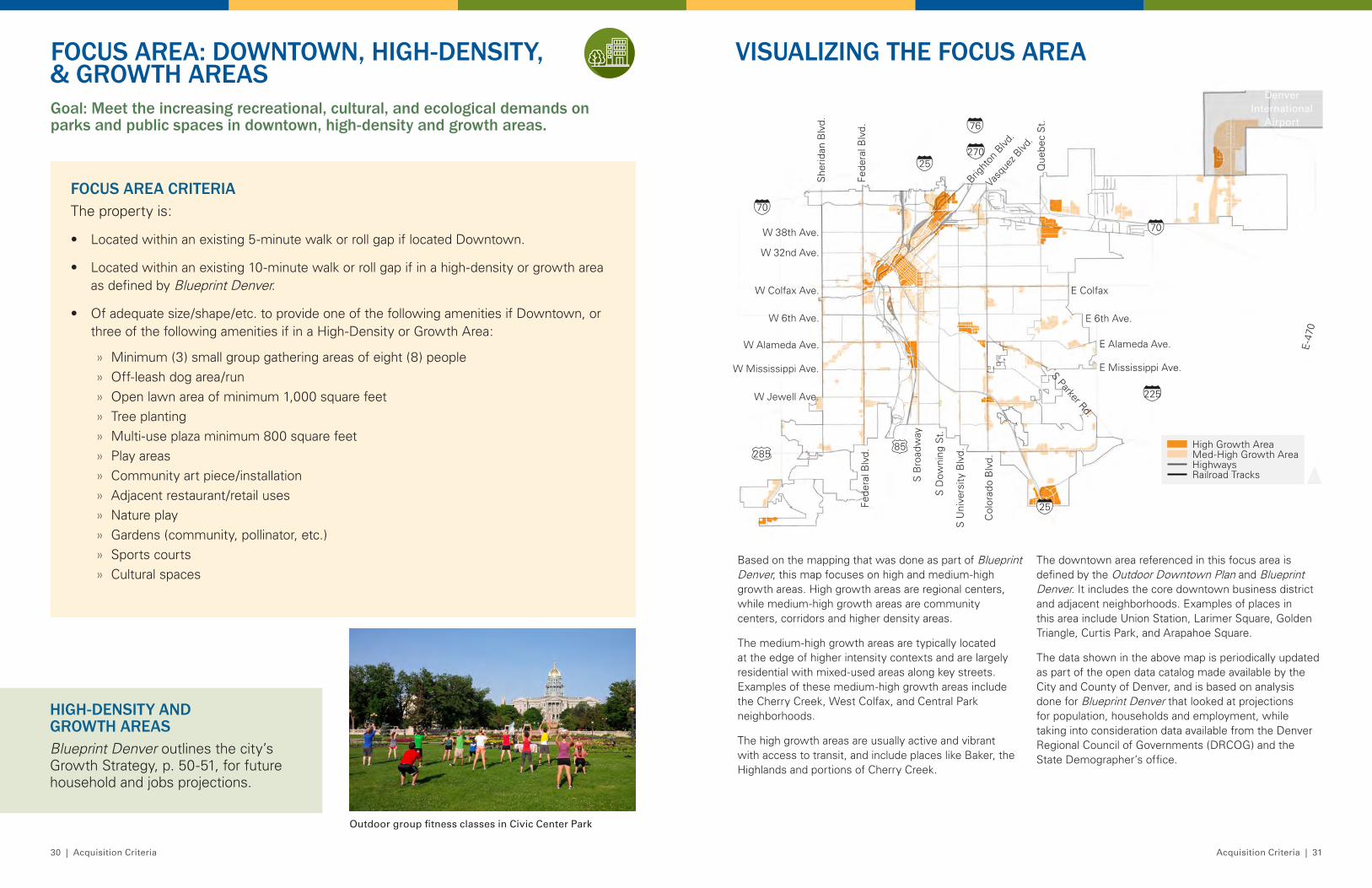
VISUALIZING THE FOCUS AREAFOCUS AREA: DOWNTOWN, HIGH-DENSITY, & GROWTH AREASGoal: Meet the increasing recreational, cultural, and ecological demands on parks and public spaces in downtown, high-density and growth areas .
FOCUS AREA CRITERIAThe property is:
• Located within an existing 5-minute walk or roll gap if located Downtown.
• Located within an existing 10-minute walk or roll gap if in a high-density or growth area as defined by Blueprint Denver.
• Of adequate size/shape/etc. to provide one of the following amenities if Downtown, or three of the following amenities if in a High-Density or Growth Area:
» Minimum (3) small group gathering areas of eight (8) people » Off-leash dog area/run » Open lawn area of minimum 1,000 square feet » Tree planting » Multi-use plaza minimum 800 square feet » Play areas » Community art piece/installation » Adjacent restaurant/retail uses » Nature play » Gardens (community, pollinator, etc.) » Sports courts » Cultural spaces
Outdoor group fitness classes in Civic Center Park
High Growth AreaMed-High Growth AreaHighwaysRailroad Tracks
W Colfax Ave.
W 6th Ave.
W Alameda Ave.
Fede
ral B
lvd.
Col
orad
o B
lvd.
Bright
on B
lvd.
Vasq
uez B
lvd.
E Colfax
E 6th Ave.S Parker Rd.
270
25
70
76
225
28585
70
25
E-4
70
E Alameda Ave.
E Mississippi Ave.W Mississippi Ave.
S B
road
way
S D
owni
ng S
t.
S U
nive
rsity
Blv
d.
W Jewell Ave.
W 38th Ave.
W 32nd Ave.
She
ridan
Blv
d.
Fede
ral B
lvd.
Que
bec
St.
Denver International
Airport
Based on the mapping that was done as part of Blueprint Denver, this map focuses on high and medium-high growth areas. High growth areas are regional centers, while medium-high growth areas are community centers, corridors and higher density areas.
The medium-high growth areas are typically located at the edge of higher intensity contexts and are largely residential with mixed-used areas along key streets. Examples of these medium-high growth areas include the Cherry Creek, West Colfax, and Central Park neighborhoods.
The high growth areas are usually active and vibrant with access to transit, and include places like Baker, the Highlands and portions of Cherry Creek.
The downtown area referenced in this focus area is defined by the Outdoor Downtown Plan and Blueprint Denver. It includes the core downtown business district and adjacent neighborhoods. Examples of places in this area include Union Station, Larimer Square, Golden Triangle, Curtis Park, and Arapahoe Square.
The data shown in the above map is periodically updated as part of the open data catalog made available by the City and County of Denver, and is based on analysis done for Blueprint Denver that looked at projections for population, households and employment, while taking into consideration data available from the Denver Regional Council of Governments (DRCOG) and the State Demographer’s office.
HIGH-DENSITY AND GROWTH AREASBlueprint Denver outlines the city’s Growth Strategy, p. 50-51, for future household and jobs projections.
10 Minute Walk or Roll
Resilience
Equity
Facilities
Downtown and High Density
Mountain Parks
32 | Acquisition Criteria Acquisition Criteria | 33
Overall Equity ScoreAreas of Greatest Need
Areas of Lowest Need
W Colfax Ave.
W 6th Ave.
W Alameda Ave.
Fede
ral B
lvd.
Col
orad
o B
lvd.
Bright
on B
lvd.
Vasq
uez B
lvd.
E Colfax
E 6th Ave.S Parker Rd.
270
25
70
76
225
28585
70
25
E-4
70
E Alameda Ave.
E Mississippi Ave.W Mississippi Ave.
S B
road
way
S D
owni
ng S
t.
S U
nive
rsity
Blv
d.
W Jewell Ave.
W 38th Ave.
W 32nd Ave.
She
ridan
Blv
d.
Fede
ral B
lvd.
Que
bec
St.
Denver International
Airport
VISUALIZING THE FOCUS AREAGoal: Proactively invest in neighborhoods in a flexible manner in coordination with other complete neighborhood needs and community benefits .
FOCUS AREA: EQUITY
FOCUS AREA CRITERIAThe property is:
• Located within or adjacent to a neighborhood with a high equity need according to DPR’s Neighborhood Equity Index.
• Directly adjacent to existing or proposed affordable housing.
• Located within a 10-minute walk or roll of existing or proposed affordable housing.
• Located adjacent to another community benefit (e.g. school, library, grocery, recreation center, medical facility, etc.) and offers the opportunity to partner with another community serving use in a high equity need neighborhood.
This map is based on DPR’s 2020 Neighborhood Equity Index. The index is made up of the following factors:
• Communities of color
• Percent youth
• Percent low income
• Health disparity indicators
• Population density
• 10-minute walk or roll park access
• 10-year capital park investment
• Park acres per 1,000 residents
As seen on this map, the darkest red areas are those in greatest need of more equitable parks and recreation services and facilities.
A Native American celebration at Confluence Park
Children enjoying the new playground at Swansea Park
Mayor Hancock at Opening Day of Paco Sanchez Park
Cuatro Vientos Park in the Westwood neighborhood
10 Minute Walk or Roll
Resilience
Equity
Facilities
Downtown and High Density
Mountain Parks
34 | Acquisition Criteria Acquisition Criteria | 35
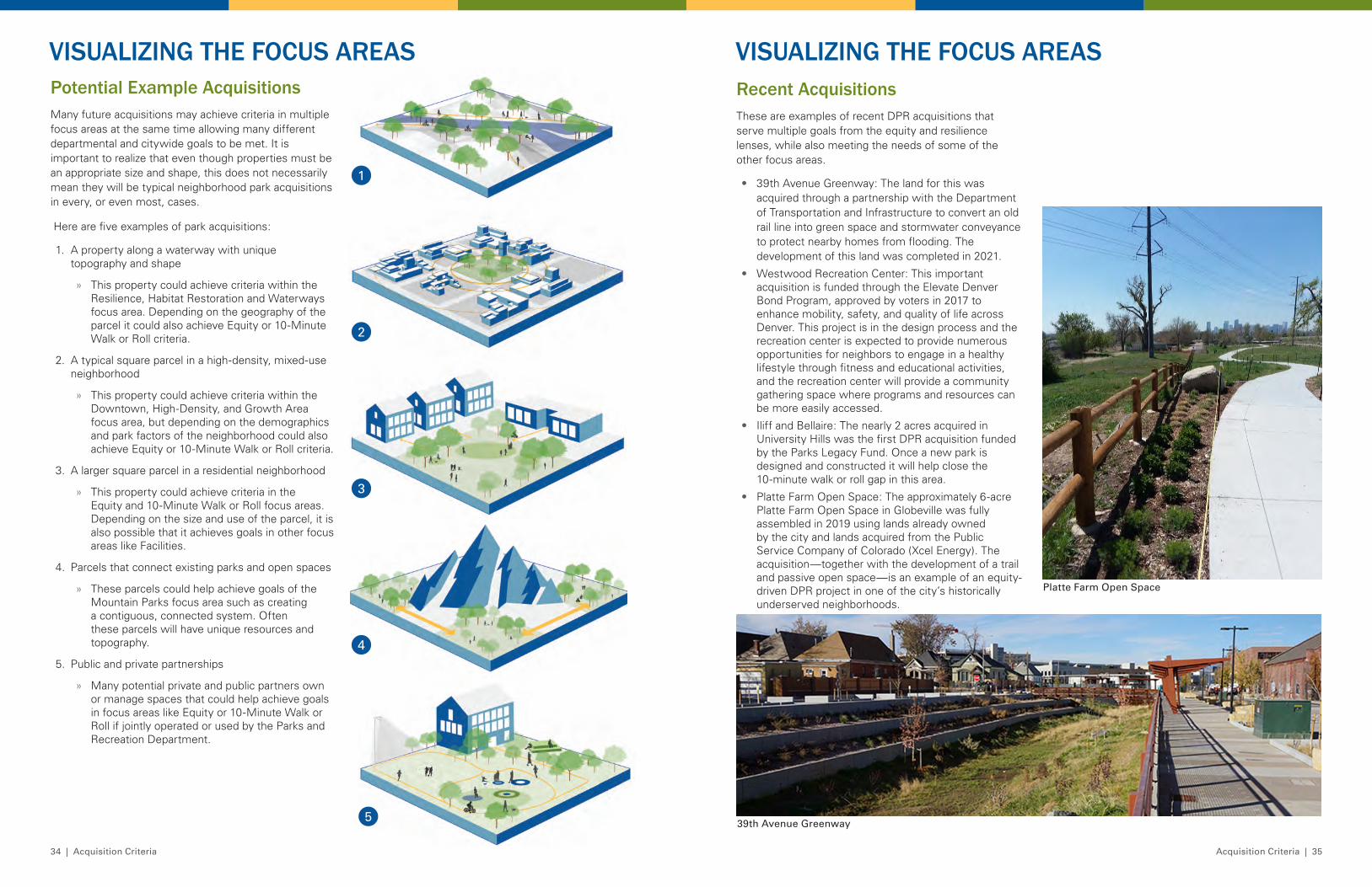
VISUALIZING THE FOCUS AREASVISUALIZING THE FOCUS AREASPotential Example AcquisitionsMany future acquisitions may achieve criteria in multiple focus areas at the same time allowing many different departmental and citywide goals to be met. It is important to realize that even though properties must be an appropriate size and shape, this does not necessarily mean they will be typical neighborhood park acquisitions in every, or even most, cases.
Here are five examples of park acquisitions:
1. A property along a waterway with unique topography and shape
» This property could achieve criteria within the Resilience, Habitat Restoration and Waterways focus area. Depending on the geography of the parcel it could also achieve Equity or 10-Minute Walk or Roll criteria.
2. A typical square parcel in a high-density, mixed-use neighborhood
» This property could achieve criteria within the Downtown, High-Density, and Growth Area focus area, but depending on the demographics and park factors of the neighborhood could also achieve Equity or 10-Minute Walk or Roll criteria.
3. A larger square parcel in a residential neighborhood
» This property could achieve criteria in the Equity and 10-Minute Walk or Roll focus areas. Depending on the size and use of the parcel, it is also possible that it achieves goals in other focus areas like Facilities.
4. Parcels that connect existing parks and open spaces
» These parcels could help achieve goals of the Mountain Parks focus area such as creating a contiguous, connected system. Often these parcels will have unique resources and topography.
5. Public and private partnerships
» Many potential private and public partners own or manage spaces that could help achieve goals in focus areas like Equity or 10-Minute Walk or Roll if jointly operated or used by the Parks and Recreation Department.
1
2
3
4
5
Recent AcquisitionsThese are examples of recent DPR acquisitions that serve multiple goals from the equity and resilience lenses, while also meeting the needs of some of the other focus areas.
• 39th Avenue Greenway: The land for this was acquired through a partnership with the Department of Transportation and Infrastructure to convert an old rail line into green space and stormwater conveyance to protect nearby homes from flooding. The development of this land was completed in 2021.
• Westwood Recreation Center: This important acquisition is funded through the Elevate Denver Bond Program, approved by voters in 2017 to enhance mobility, safety, and quality of life across Denver. This project is in the design process and the recreation center is expected to provide numerous opportunities for neighbors to engage in a healthy lifestyle through fitness and educational activities, and the recreation center will provide a community gathering space where programs and resources can be more easily accessed.
• Iliff and Bellaire: The nearly 2 acres acquired in University Hills was the first DPR acquisition funded by the Parks Legacy Fund. Once a new park is designed and constructed it will help close the 10-minute walk or roll gap in this area.
• Platte Farm Open Space: The approximately 6-acre Platte Farm Open Space in Globeville was fully assembled in 2019 using lands already owned by the city and lands acquired from the Public Service Company of Colorado (Xcel Energy). The acquisition—together with the development of a trail and passive open space—is an example of an equity-driven DPR project in one of the city’s historically underserved neighborhoods.
39th Avenue Greenway
Platte Farm Open Space
37
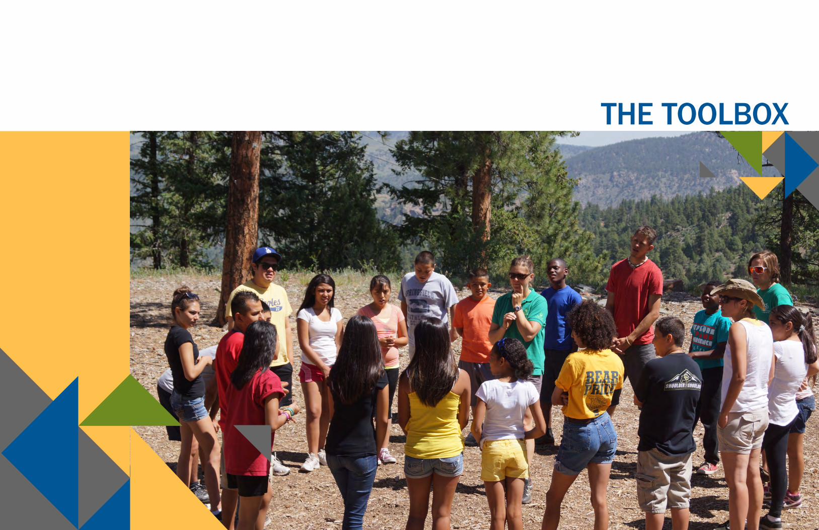
THE TOOLBOX
38 | The Toolbox The Toolbox | 39
ACQUISITION TOOLBOX & FUNDING MECHANISMSAcquiring land to develop future parks, open spaces, and trails to grow and maintain an equitable, sustainable, and resilient parks and recreation system for a healthier Denver will not be easy, but will be worthwhile. Diverse funding mechanisms innovatively coupled with proven real estate tools, together in coordination with other city agencies and partner organizations, will help DPR meet the vision and outcomes of this Strategic Acquisition Plan.
Funding Mechanisms Successful acquisition projects require funding mechanisms and financial frameworks that not only include purchase costs, but also the cost to integrate the property into the DPR system and manage it for the longterm. DPR acquisitions will be funded primarily through the Parks Legacy Fund derived exclusively from a 0.25 percent sales tax dedicated to the improvement and expansion of DPR’s system. The following are possible funding mechanisms, tools, and strategies in addition to the Parks Legacy Fund that DPR can leverage to acquire land and properties for parks, open spaces, and trails especially in areas where real estate values and competition are high.
Bonds Debt instruments such as bonding can be a plausible funding strategy in certain situations. Bonding is typically done on a coordinated citywide scale involving multiple city agencies. Local municipalities generally have the authority to issue bonds, though if the bond is funded through tax revenue, the municipality likely requires strong community support and a vote of approval from residents.
In the case of future parks and open space acquisitions, DPR could pursue the issuance of General Obligation (GO) Bonds. A GO bond is a type of municipal bond that is guaranteed by the credit and taxing ability of the issuing jurisdiction, rather than the revenue from a specific project, such as a toll road or bridge. Any purchase strategy involving GO bonds should be tied to a larger public engagement campaign that builds community support for leveraging tax revenue for parks and open space development. An example of a DPR acquisition utilizing bond funding is the Westwood Recreation Center project, which is funded through the Elevate Denver Bond Program, approved by voters in 2017 to enhance mobility, safety, and quality of life across Denver.
Grants As part of its effort to leverage acquisition funding, DPR can explore a variety of grant funding options. Grants for parks and open space development, including acquisitions, are funded through public or private entities, and are often tied to specific development or programming initiatives. Grant opportunities to help fund the development of a new acquisition into a park can be explored during the pre-acquisition planning process as well. By staying apprised of all relevant private and public grant opportunities, DPR can maximize its chance of securing grant funding.
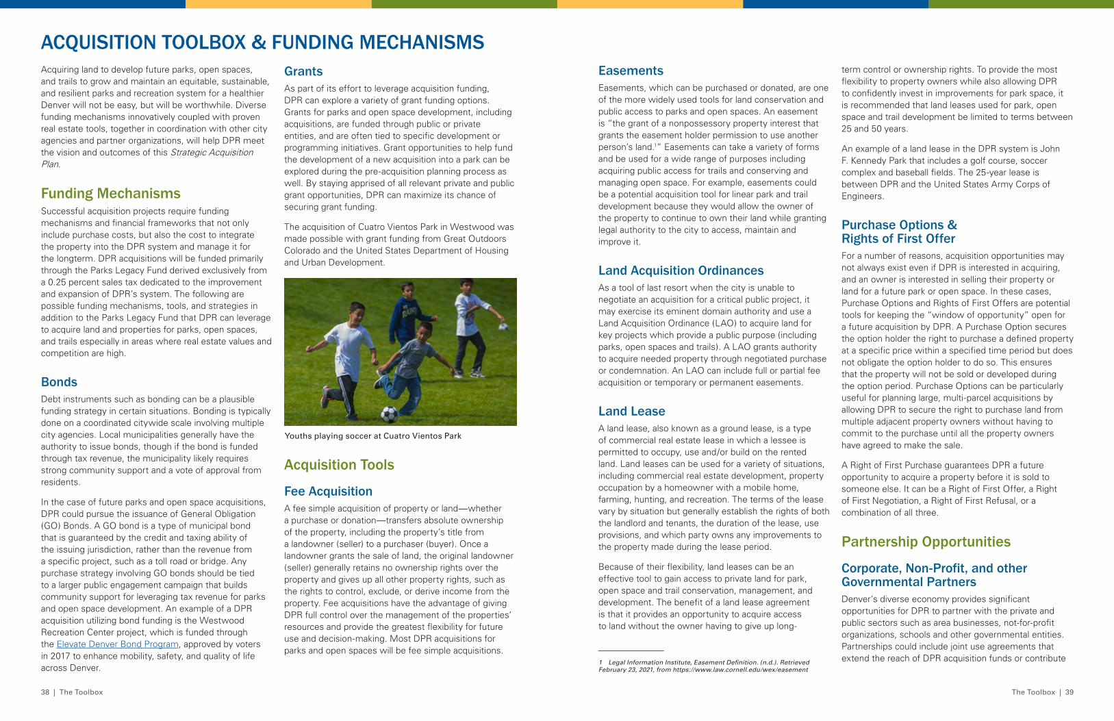
The acquisition of Cuatro Vientos Park in Westwood was made possible with grant funding from Great Outdoors Colorado and the United States Department of Housing and Urban Development.
Acquisition Tools
Fee Acquisition A fee simple acquisition of property or land—whether a purchase or donation—transfers absolute ownership of the property, including the property’s title from a landowner (seller) to a purchaser (buyer). Once a landowner grants the sale of land, the original landowner (seller) generally retains no ownership rights over the property and gives up all other property rights, such as the rights to control, exclude, or derive income from the property. Fee acquisitions have the advantage of giving DPR full control over the management of the properties’ resources and provide the greatest flexibility for future use and decision-making. Most DPR acquisitions for parks and open spaces will be fee simple acquisitions.
Easements Easements, which can be purchased or donated, are one of the more widely used tools for land conservation and public access to parks and open spaces. An easement is “the grant of a nonpossessory property interest that grants the easement holder permission to use another person’s land.1” Easements can take a variety of forms and be used for a wide range of purposes including acquiring public access for trails and conserving and managing open space. For example, easements could be a potential acquisition tool for linear park and trail development because they would allow the owner of the property to continue to own their land while granting legal authority to the city to access, maintain and improve it.
Land Acquisition OrdinancesAs a tool of last resort when the city is unable to negotiate an acquisition for a critical public project, it may exercise its eminent domain authority and use a Land Acquisition Ordinance (LAO) to acquire land for key projects which provide a public purpose (including parks, open spaces and trails). A LAO grants authority to acquire needed property through negotiated purchase or condemnation. An LAO can include full or partial fee acquisition or temporary or permanent easements.
Land Lease A land lease, also known as a ground lease, is a type of commercial real estate lease in which a lessee is permitted to occupy, use and/or build on the rented land. Land leases can be used for a variety of situations, including commercial real estate development, property occupation by a homeowner with a mobile home, farming, hunting, and recreation. The terms of the lease vary by situation but generally establish the rights of both the landlord and tenants, the duration of the lease, use provisions, and which party owns any improvements to the property made during the lease period.
Because of their flexibility, land leases can be an effective tool to gain access to private land for park, open space and trail conservation, management, and development. The benefit of a land lease agreement is that it provides an opportunity to acquire access to land without the owner having to give up long-
1 Legal Information Institute, Easement Definition. (n.d.). Retrieved February 23, 2021, from https://www.law.cornell.edu/wex/easement
Youths playing soccer at Cuatro Vientos Park
term control or ownership rights. To provide the most flexibility to property owners while also allowing DPR to confidently invest in improvements for park space, it is recommended that land leases used for park, open space and trail development be limited to terms between 25 and 50 years.
An example of a land lease in the DPR system is John F. Kennedy Park that includes a golf course, soccer complex and baseball fields. The 25-year lease is between DPR and the United States Army Corps of Engineers.
Purchase Options & Rights of First OfferFor a number of reasons, acquisition opportunities may not always exist even if DPR is interested in acquiring, and an owner is interested in selling their property or land for a future park or open space. In these cases, Purchase Options and Rights of First Offers are potential tools for keeping the “window of opportunity” open for a future acquisition by DPR. A Purchase Option secures the option holder the right to purchase a defined property at a specific price within a specified time period but does not obligate the option holder to do so. This ensures that the property will not be sold or developed during the option period. Purchase Options can be particularly useful for planning large, multi-parcel acquisitions by allowing DPR to secure the right to purchase land from multiple adjacent property owners without having to commit to the purchase until all the property owners have agreed to make the sale.
A Right of First Purchase guarantees DPR a future opportunity to acquire a property before it is sold to someone else. It can be a Right of First Offer, a Right of First Negotiation, a Right of First Refusal, or a combination of all three.
Partnership Opportunities
Corporate, Non-Profit, and other Governmental Partners Denver’s diverse economy provides significant opportunities for DPR to partner with the private and public sectors such as area businesses, not-for-profit organizations, schools and other governmental entities. Partnerships could include joint use agreements that extend the reach of DPR acquisition funds or contribute
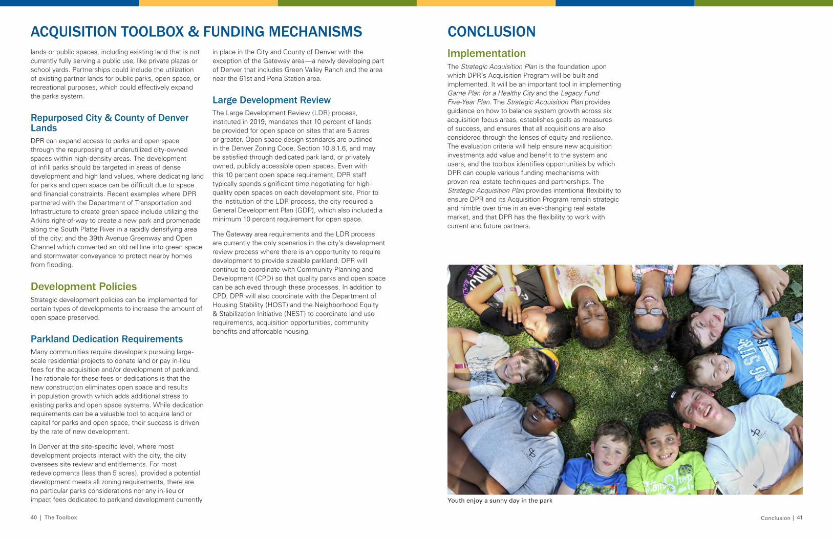
40 | The Toolbox The Toolbox | 41
lands or public spaces, including existing land that is not currently fully serving a public use, like private plazas or school yards. Partnerships could include the utilization of existing partner lands for public parks, open space, or recreational purposes, which could effectively expand the parks system.
Repurposed City & County of Denver LandsDPR can expand access to parks and open space through the repurposing of underutilized city-owned spaces within high-density areas. The development of infill parks should be targeted in areas of dense development and high land values, where dedicating land for parks and open space can be difficult due to space and financial constraints. Recent examples where DPR partnered with the Department of Transportation and Infrastructure to create green space include utilizing the Arkins right-of-way to create a new park and promenade along the South Platte River in a rapidly densifying area of the city; and the 39th Avenue Greenway and Open Channel which converted an old rail line into green space and stormwater conveyance to protect nearby homes from flooding.
Development PoliciesStrategic development policies can be implemented for certain types of developments to increase the amount of open space preserved.
Parkland Dedication RequirementsMany communities require developers pursuing large-scale residential projects to donate land or pay in-lieu fees for the acquisition and/or development of parkland. The rationale for these fees or dedications is that the new construction eliminates open space and results in population growth which adds additional stress to existing parks and open space systems. While dedication requirements can be a valuable tool to acquire land or capital for parks and open space, their success is driven by the rate of new development.
In Denver at the site-specific level, where most development projects interact with the city, the city oversees site review and entitlements. For most redevelopments (less than 5 acres), provided a potential development meets all zoning requirements, there are no particular parks considerations nor any in-lieu or impact fees dedicated to parkland development currently
in place in the City and County of Denver with the exception of the Gateway area—a newly developing part of Denver that includes Green Valley Ranch and the area near the 61st and Pena Station area.
Large Development ReviewThe Large Development Review (LDR) process, instituted in 2019, mandates that 10 percent of lands be provided for open space on sites that are 5 acres or greater. Open space design standards are outlined in the Denver Zoning Code, Section 10.8.1.6, and may be satisfied through dedicated park land, or privately owned, publicly accessible open spaces. Even with this 10 percent open space requirement, DPR staff typically spends significant time negotiating for high-quality open spaces on each development site. Prior to the institution of the LDR process, the city required a General Development Plan (GDP), which also included a minimum 10 percent requirement for open space.
The Gateway area requirements and the LDR process are currently the only scenarios in the city’s development review process where there is an opportunity to require development to provide sizeable parkland. DPR will continue to coordinate with Community Planning and Development (CPD) so that quality parks and open space can be achieved through these processes. In addition to CPD, DPR will also coordinate with the Department of Housing Stability (HOST) and the Neighborhood Equity & Stabilization Initiative (NEST) to coordinate land use requirements, acquisition opportunities, community benefits and affordable housing.
ACQUISITION TOOLBOX & FUNDING MECHANISMS CONCLUSIONImplementationThe Strategic Acquisition Plan is the foundation upon which DPR’s Acquisition Program will be built and implemented. It will be an important tool in implementing Game Plan for a Healthy City and the Legacy Fund Five-Year Plan. The Strategic Acquisition Plan provides guidance on how to balance system growth across six acquisition focus areas, establishes goals as measures of success, and ensures that all acquisitions are also considered through the lenses of equity and resilience. The evaluation criteria will help ensure new acquisition investments add value and benefit to the system and users, and the toolbox identifies opportunities by which DPR can couple various funding mechanisms with proven real estate techniques and partnerships. The Strategic Acquisition Plan provides intentional flexibility to ensure DPR and its Acquisition Program remain strategic and nimble over time in an ever-changing real estate market, and that DPR has the flexibility to work with current and future partners.
Conclusion
Youth enjoy a sunny day in the park


