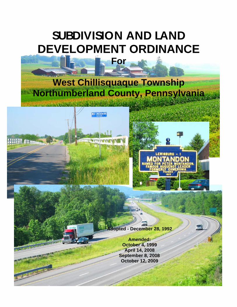
SUBDIVISION AND LAND DEVELOPMENT ORDINANCE For West Chillisquaque Township Northumberland County, Pennsylvania Adopted - December 28, 1992 Amended: October 4, 1999 April 14, 2008 September 8, 2008 October 12, 2009
Transcript
SUBDIVISION AND LAND DEVELOPMENT ORDINANCE
For
West Chillisquaque Township Northumberland County, Pennsylvania
Adopted - December 28, 1992
Amended:
October 4, 1999 April 14, 2008
September 8, 2008 October 12, 2009
SUBDIVISION AND LANDDEVELOPMENT ORDINANCE
for
West Chillisquaque TownshipNorthumberland County, Pennsylvania
prepared by a committee comprised of:
West Chillisquaque Township Planning CommissionWest Chillisquaque Township Zoning Hearing Board
West Chillisquaque Township SupervisorsRobert E. Benion, Township Solicitor
Cummings & Smith, Inc., Consulting EngineersDouglas W. Hovey, Project Planner
OFFICIAL ORDINANCE
Adopted - December 28, 1992
Amended:October 4, 1999April 14, 2008
September 8, 2008October 12, 2009
Cummings & Smith, Inc., Consulting Engineers8163 U.S. Highway 15
Montgomery, PA 17752
ii
EXECUTIVE SUMMARY
Definition of Subdivision
"Subdivision," the division or redivision of a lot, tract, or parcel of land by any means into two ormore lots, tracts, parcels or other divisions of land including changes in existing lot lines for thepurpose, whether immediate or future, of lease, partition by the court for distribution to heirs ordevisees, transfer of ownership or building development: Provided, however, That the subdivisionby lease of land for agricultural purposes into parcels of more than ten acres, not involving any newstreets or easement of access or any residential dwelling, shall be exempted.
Definition of Land Development
"Land Development," any of the following activities:
The improvement of one lot or two or more contiguous lots, tracts or parcels of land for anypurpose involving:
(i) a group of two or more residential or nonresidential buildings, whether proposedinitially or cumulatively, or a single nonresidential building on a lot or lots regardlessof the number of occupants or tenure; or
(ii) the division or allocation of land or space, whether initially or cumulatively,between or among two or more existing or prospective occupants by means of, or forthe purpose of streets, common areas, leaseholds, condominiums, building groupsor other features.
A subdivision of land.
Exception from Subdivision Definition
Where small portions of existing lots, tracts, or parcels of land are being acquired by governmentalunits or public utilities for use in road improvements, utility lines, or utility structures, thesedivisions of land may be exempt from the requirements of this Ordinance as per P.U.C. regulations,state law, or federal law.
Exception from Land Development Definition
Act 170 of 1988 provides for the exclusion of certain activities from the definition of landdevelopment. The following shall not be regarded as land development in West ChillisquaqueTownship:
(i) The conversion of an existing single-family detached dwelling or single-family semi-detached dwelling into not more than three residential units, unless such units are intendedto be a condominium;
iii
(ii) The addition of any accessory building, including farm buildings, on a lot or lotssubordinate to an existing principal building; or
(iii)The addition or conversion of buildings or rides within the confines of an enterprisewhich would be considered an amusement park. For purposes of this subclass, anamusement park is defined as a tract or area used principally as a location for permanentamusement structures or rides. This exclusion shall not apply to newly acquired acreage byan amusement park until plans for the expanded area have been approved by properauthorities.
Jurisdiction
The West Chillisquaque Township Supervisors shall have the Authority to approve or disapproveall subdivision and land development plans for the township. The Township Planning Commissionand other review agencies shall be accorded the opportunity to review plans in accord with the timelimits stipulated in this Ordinance.
Abbreviated Table of Contents
Section 1 - General Provisions and Administration
Section 2 - Procedures
Section 3 - Plan Requirements
Section 4 - Subdivision and Design Construction Standards
Section 5 - Mobile Home Parks
Section 6 - Land Development Requirements
Section 7 - Definitions
List of Tables
Table 4-1 Minimum Street, Curb, and Sidewalk Design Standards
Table 4-2 Driveway Design Standards
Table 4-3 Street, Curb, and Sidewalk Construction Standards
iv
Time Limits Specified For Subdivision and Land Development Procedures
A summary of the procedural actions that may be taken by the Applicant, the Township, and/or theTownship Planning Commission during the development of a plan is presented below along withthe Section reference where a detailed explanation of the procedure is located:
Review By Northumberland County Planning Commission - Section 1.4.1. - TheNorthumberland County Planning Commission shall provide its review within 30 days of the dateof submission of the plan for review.
Disputed Review Fees - Section 1.9.3.1. - Any dispute of engineering review fees shall be initiatedby the applicant within 10 days of the billing date.
Plan Submission - Section 2.1.3. - All plans shall be submitted at least 14 days in advance of themeeting at which they are to be considered.
Referral Of Plans - Section 2.1.5. - The Township Secretary shall forward preliminary and finalplans to review agencies upon receipt of said plans.
Final Plan Submission - Section 2.2.3.4. - Final plans shall be submitted within 5 years ofPreliminary Plan approval.
Plan Approval - Section 2.3.1. - The Township Supervisors shall render its decision andcommunicate it to the applicant within 90 days of the next meeting following plan submission.
Communication Of Decision To Applicant - Section 2.3.2.1. - Township Supervisor decisionsshall be in writing and delivered to the applicant or mailed to him within 15 days of the decision.
Acknowledgement Of Conditional Approval By Applicant - Section 2.3.3. - Applicants shallreturn executed concurrence to the Township Supervisors within 30 days of the conditionalapproval.
Approval Resolution To Facilitate Financing - Section 2.3.4. - This resolution shall expire within90 days if an Improvements Guarantee Agreement is not executed.
Improvements Guarantee Agreement - Section 2.4.2.3. - Improvements Guarantee Agreementsshall be valid for one year unless extended by increasing the guarantee fund amount.
Inspection By Township Representative - Section 2.4.3. - The applicant shall give the Township48 hours notice in advance of the installation of required improvements so that a townshiprepresentative may be present to inspect their installation.
Inspection By Engineer - Section 2.4.3.1. - The inspection of required improvements by theTownship Engineer shall occur within 45 days of the request to release improvements guaranteefunds.
Completion Of Improvements - Section 2.4.3.2. - The Township shall authorize an engineeringinspection within 10 days of notice that the improvements are complete.
Engineer's Report Concerning Completeness of Improvements - Section 2.4.3.2. - The engineers
v
report shall be made to the applicant by certified mail within 30 days of the inspection authorization.
Maintenance Guarantee - Section 2.4.4.2. - The Township may require a maintenance guaranteeto insure the integrity of the improvements for 18 months from the acceptance of the dedication ofthe improvements.
Recording Final Plan - Section 2.5.1. - Final plan approval by the Township Supervisors shallbecome null and void if the plan is not recorded at the Union County Recorders Office within 90days of notification of final plan approval.
viii
Table of Contents
West Chillisquaque TownshipSubdivision and Land Development Ordinance
Definition of SubdivisionDefinition of Land DevelopmentException from Subdivision DefinitionException from Land Development DefinitionJurisdictionAbbreviated Table of ContentsList of TablesTime Limits
2.3.1 Deadline For Action By The Township Supervisors2.3.2 Notification To Applicant2.3.3 Conditional Approval2.3.4 Optional Approval Resolution To Facilitate Financing
2.4.1 General Requirements2.4.2 Improvements Guarantee Agreement2.4.3 Inspection of Improvements2.4.4 Dedication Of Improvements/ Maintenance Guarantee
4.5.1 Minimum Street, Curb, and Sidewalk Design Standards4.5.2 Right-Of-Way4.5.3 Cul-De-Sac Streets4.5.4 Street System Layout4.5.5 Street Intersections4.5.6 Street Grades and Alignments
4.15.2.1 10 Lots Or Less Utilizing On-Lot Facilities4.15.2.2 More Than 10 Lots Utilizing On-Lot Facilities, Private SewerSystem, or Sewer Extension Of A Public Sewer System4.15.2.3 Subdivision Not Approved For On-Lot Sewage Disposal
5.3.1 Utilities, Services, and Controls5.3.2 Internal Street System5.3.3 Parking Space5.3.4 Grading and Ground Cover5.3.5 Mobile Home Pads5.3.6 Mobile Home Patio5.3.7 Recreation and Open Space5.3.8 Screening and Landscaping
THE SUPERVISORS OF THE TOWNSHIP OF WEST CHILLISQUAQUE,NORTHUMBERLAND COUNTY, PENNSYLVANIA, HEREBY ORDAIN AND ENACT:
ARTICLE 1General Provisions and Administration
1.1 Short Title
These regulations shall be known and may be cited as the "West Chillisquaque TownshipSubdivision and Land Development Ordinance".
1.2 Authority
The Board of Supervisors of the Township of West Chillisquaque is vested by law with theauthority to regulate subdivision and land development within the Township by Section 501 ofthe Pennsylvania Municipalities Planning Code (Act 247 of 1968, as amended by Act 170 of1988).
1.3 Purpose
These regulations are adopted for the following purposes:
1.3.1 To protect and provide for the public health, safety, and general welfare of the Township.
1.3.2 To guide the future growth and development of West Chillisquaque, in accordance withthe Comprehensive Plan of the Township.
1.3.3 To provide for adequate light, air, and privacy; to secure safety from fire, flood, andother danger; and to prevent overcrowding of the land and undue congestion ofpopulation.
1.3.4 To protect the character and the social and economic stability of the Township and toencourage the orderly and beneficial development of all parts of the Township.
1.3.5 To protect and conserve the value of land throughout the Township, and the value ofbuildings and improvements upon the land, and to minimize the conflicts among the usesof land and buildings.
1.3.6 To guide public and private policy and action in order to provide adequate and efficienttransportation, water supply, sewerage, schools, parks, playgrounds, recreation, and otherpublic requirements and facilities.
1.3.7 To provide the most beneficial relationship between the uses of land and buildings andthe circulation of traffic within the Township, having particular regard to the avoidanceof congestion in the streets and highways, and the pedestrian traffic movementsappropriate to the various uses of land and buildings, and to provide for the proper
1-2
location and width of streets and building lines.
1.3.8 To establish reasonable standards of design and procedures for subdivision andresubdivisions, in order to further the orderly layout and use of land; and to insure properlegal descriptions and monumenting of subdivided land.
1.3.9 To insure that public facilities are available and will have a sufficient capacity to servethe proposed subdivision.
1.3.10 To prevent the pollution of air, streams, and ponds; to assure the adequacy of drainagefacilities; to safeguard the water table; and to encourage the wise use and managementof natural resources in order to preserve the community and value of the land.
1.3.11 To preserve the natural beauty and topography of the Township and to insure appropriatedevelopment with regard to these natural features.
1.3.12 To provide for open spaces through the most efficient design and layout of the land.
1.3.13 And finally, to ensure that documents prepared as part of a land ownership transfer fullyand accurately describe the parcel of land being subdivided, and the new parcels thuscreated.
1.4 Jurisdiction
The West Chillisquaque Township Supervisors shall approve or disapprove all Subdivision andLand Development Plans for the Township.
1.4.1 Review By The Northumberland County Planning Commission
All plans for subdivision and land development within the township shall be forwarded,upon receipt by the township to the Northumberland County Planning Commission forreview and recommendation. The township shall not approve or disapprove such plansuntil the County Planning Commission report is received or until the expiration of 30days from the submission of the plan to the County Planning Commission, or within suchfurther time as may be agreed upon between the County and the township.
A copy of the Northumberland County Planning Commission report shall be submittedto the Township Planning Commission for its review prior to township approval ordisapproval of the plan.
1.4.2 Review By The West Chillisquaque Township Planning Commission
All plans for subdivision and land development received by the township shall bereviewed by the West Chillisquaque Township Planning Commission prior to any actionby the Township Supervisors to approve or disapprove such plans. The TownshipPlanning Commission may rely upon the review received from the NorthumberlandCounty Planning Commission to aid in its deliberations. Review comments from theTownship Planning Commission shall be transmitted to the Township Supervisors inwriting.
1-3
1.5 Conflict and Severability
1.5.1 Conflict With Other Ordinances
Should any provision of this Ordinance be found in conflict with the provisions of azoning, building, fire, safety, health, or other ordinance or code of the township, theprovision which establishes the higher standard for the protection of the health and safetyof the township shall prevail.
1.5.2 Conflict With Private Provisions
This ordinance is not intended to invalidate any easement, covenant or any other privateagreement or restriction, provided that where the provisions of this ordinance are morerestrictive or impose higher standards or regulations than such easement, covenant, orother private agreement or restriction, the requirements of this ordinance shall govern.
Where the provisions of the easement, covenant or private agreement or restrictionimpose duties and obligations more restrictive, then the private provisions shall remainin effect and shall be operative and supplemental to these regulations.
1.5.3 Severability
Should any section, subsection, or provision of this Ordinance be declared by a courtof competent jurisdiction to be invalid, such decision shall not affect the validity ofOrdinance as a whole, or of any other part thereof. The Board of Supervisors of theTownship of West Chillisquaque hereby declares that it would have enacted theremainder of this ordinance even without any such part, provision, or application.
1.6 Amendment
The West Chillisquaque Township Supervisors may, from time to time, revise, modify, andamend this Ordinance by appropriate action taken at a scheduled public meeting, in accord withSection 505 of Act 170 of 1988, as amended.
1.7 Waivers or Modifications
The Township Supervisors may grant a waiver or modification to the minimum standards of theSubdivision and Land Development Ordinance when the literal compliance with mandatoryprovisions is shown to the satisfaction of the Supervisors to be unreasonable, to cause unduehardship, or when an alternative standard can be demonstrated to provide equal or better results.Furthermore, the Supervisors may grant a modification of the requirements of one or moreprovisions if the literal enforcement will exact undue hardship because of peculiar conditionspertaining to the land in question, provided that such modifications will not be contrary to thepublic interest and that the purpose and intent of this Ordinance is observed.
1.7.1 Procedures
1.7.1.1 All requests for a waiver or modification shall be in writing and shall accompanythe application for subdivision or land development. The request shall state the
1-4
grounds and facts of unreasonableness or hardship on which the request is based,the provision or provisions of the Ordinance involved and the minimummodification necessary.
1.7.1.2 The request for the modification shall be referred to the Planning Commissionfor advisory comments.
1.7.1.3 The Township Supervisors shall keep a written record of all action on themodification request.
1.8 Records
The Township Supervisors shall keep for the public record all plans upon which it takes action.The Supervisors shall also keep a record of all decisions and actions related thereto.
1.9 Required Fees
The Board of Supervisors shall by Resolution establish the required subdivision plan applicationand review fees. All fees shall be payable to West Chillisquaque Township.
1.9.1 Subdivision Plan Application Fee
The purpose of the subdivision plan application fee shall be to cover a portion of the planprocessing cost incurred by the township.
1.9.2 Review Fees
The Township shall charge review fees to cover the actual cost of retaining the municipalengineer or consultant to evaluate subdivision plans or to inspect required improvements.
1.9.3 Disputed Review Fees
1.9.3.1 In the event the applicant disputes the amount of any such review fees, theapplicant shall, within ten days of the billing date, notify the municipality thatsuch fees are disputed, in which case the municipality shall not delay ordisapprove a subdivision or land development application due to the applicant'srequest over disputed fees.
1.9.3.2 In the event that the municipality and the applicant cannot agree on the amountof review fees which are reasonable and necessary, then the applicant and themunicipality shall follow the procedure for dispute resolution set forth in section510(g) of Act 170 of 1988, as amended, the Pennsylvania MunicipalitiesPlanning Code.
1-5
1.10 Preventive Remedies
1.10.1 In addition to other remedies, the Township may institute and maintain appropriateactions by law or in equity to restrain, correct or abate violations, to prevent unlawfulconstruction, to recover damages and to prevent illegal occupancy of a building,structure, or premises. The description by metes and bounds in instrument of transferor other documents used in the process of selling or transferring shall not exempt theseller or transferor from such penalties or from the remedies herein provided.
1.10.2 The Township may refuse to issue any permit or grant any approval necessary to furtherimprove or develop any real property which has been developed or which has resultedfrom a subdivision of real property in violation of any ordinance adopted pursuant toArticle V of Act 170 of 1988. This authority to deny such a permit or approval shallapply to any of the following applicant:
1.10.2.1 The owner of record at the time of such violation.
1.10.2.2 The vendee or lessee of the owner of record at the time of such violationwithout regard as to whether such vendee or lessee had actual orconstructive knowledge of the violation.
1.10.2.3 The current owner of record who acquired the property subsequent to thetime of violation without regard as to whether such current owner hadactual or constructive knowledge of the violation.
1.10.2.4 The vendee or lessee of the current owner of record who acquired theproperty subsequent to the time of violation without regard as to whethersuch vendee or lessee had actual or constructive knowledge of theviolation.
As an additional condition for issuance of a permit or the granting of anapproval to any such owner, current owner, vendee or lessee for thedevelopment of any such real property, the Township may requirecompliance with the conditions that would have been applicable to theproperty at the time the applicant acquired an interest in such realproperty.
1.11 Enforcement Remedies
1.11.1 Any person, partnership, or corporation who or which has violated the provisions of anysubdivision or land development ordinance enacted under this act or prior enabling lawsshall, upon being found liable therefor in a civil enforcement proceeding commenced bythe Township, pay a judgment of not more than $500 plus all court costs, includingreasonable attorney fees incurred by the Township as a result thereof. No judgment shallcommence or be imposed, levied or payable until the date of the determination of aviolation by the district justice. If the defendant neither pays nor timely appeals thejudgment, the township may enforce the judgment pursuant to the applicable rules ofcivil procedure. Each day that a violation continues shall constitute a separate violation,unless the district justice determining that there has been a violation further determinesthat there was a good faith basis for the person, partnership, or corporation violating the
1-6
ordinance to have believed that there was no such violation, in which event there shallbe deemed to have been only one such violation until the fifth day following the date ofthe determination of a violation by the district justice and thereafter each day that aviolation continues shall constitute a separate violation.
1.11.2 The court of common pleas, upon petition, may grant an order of stay, upon causeshown, tolling the per diem judgment pending a final adjudication of the violation andjudgment.
1.11.3 Nothing contained in this section shall be construed or interpreted to grant to any personor entity other than the Township the right to commence any action for enforcementpursuant to this section.
1.11.4 District justices shall have initial jurisdiction in proceedings brought under this section.
1.12 Prior Ordinances and Amendments
1.12.1 The West Chillisquaque Subdivision and Land Development Ordinance became effectiveduring February, 1979. Final plans submitted prior to February, 1979, for which apreliminary plan had previously been approved, were governed by the NorthumberlandCounty Subdivision Regulations of 1976.
1.12.2. The 1992 West Chillisquaque Township Subdivision and Land Development Ordinancebecame effective to all preliminary and final plans submitted to the Township on or afterDecember 28, 1992, except those final plans for which a preliminary plan had previouslybeen approved. In such case, the West Chillisquaque Subdivision and LandDevelopment Ordinance of 1979 was in effect.
1.12.3 This Ordinance serves to amend under the terms of Section 505 of the PennsylvaniaMunicipalities Planning Code, Act of 1988, P.L. 805, No. 247, the 1992 WestChillisquaque Township Subdivision and Land Development Ordinance and anysubsequent amendments to that Ordinance including the amendment of October 4, 1999.
2-1
ARTICLE 2
Procedures
22.1 GENERAL PROCEDURE
The procedures established in this Article shall apply to all subdivisions and land developmentsthat require approval by West Chillisquaque Township. It shall be the responsibility of theapplicant to submit preliminary or final subdivision or land development plans that comply inall respects with the applicable provisions of this ordinance and to coordinate planning withutility or service agencies in the manner set forth in this ordinance.
2.1.1 Classifications Of Subdivision
2.1.1.1 Minor Subdivision
A minor subdivision is a subdivision of lots fronting on a public road and notinvolving the creation of any new streets. Note that the residual lot shall becounted as a lot. A minor subdivision is exempted from many of the planrequirements specified for a major subdivision. The plan requirements for MinorSubdivisions are specified in Section 3.4 of this Ordinance.
2.1.1.2 Add-On Subdivision
An add-on subdivision is the creation of a lot which is to be added to an existingcontiguous lot and where no new building lot or land development is proposed.The plan requirements for an add-on subdivision are specified in Section 3.5 ofthis Ordinance.
2.1.1.3 Major Subdivision
All subdivisions which are not classified as minor or add-on subdivisions aremajor subdivisions and shall comply with all pertinent plan requirements of thisOrdinance (see Sections 3.2, 3.6, and 3.7).
2.1.2 Classifications Of Land Development
2.1.2.1 Minor Land Development
Minor land development includes:
» A single non-residential building of less than 2,000 square feet in size;or
» The placement of two (2) single family detached dwellings on a singlelot.
A plan for a minor land development shall be prepared in accord with the planrequirements specified in Section 3.3 of this Ordinance.
2-2
2.1.2.2 Major Land Development
Major land development includes:
» A non-residential building greater than 2,000 square feet in size; or
» Two or more non-residential buildings on a single lot; or
» Four (4) or more residential units or three or more residential structureson a single lot; or
» Mobile Home Parks.
A major land development shall be prepared in accord with the plan requirementsspecified in Sections 3.2, 3.6, and 3.7 of this Ordinance.
2.1.2.3 Land Development Exceptions
Act 170 of 1988 provides for the exclusion of certain activities from thedefinition of land development. The following shall not be regarded as landdevelopment in West Chillisquaque Township although applicable zoningregulations shall apply:
» The conversion of an existing single-family detached dwelling orsingle-family semi-detached dwelling into not more than three residentialunits, unless such units are intended to be a condominium; or
» The addition of any accessory building, including farm buildings, on alot or lots subordinate to an existing principal building; or
» The addition or conversion of buildings or rides within the confines ofan enterprise which would be considered an amusement park. Forpurposes of this subclass, an amusement park is defined as a tract or areaused principally as a location for permanent amusement structures orrides. This exclusion shall not apply to newly acquired acreage by anamusement park until plans for the expanded area have been approved byproper authorities.
2.1.3 Official Submission Dates
For the purpose of these regulations the official submission date is the date when all theplans and materials, including review fees, are received at the Township Office by theSecretary or a designee. Plans shall be submitted to the Township Planning Commissionnot less that 14 days in advance of the regular meeting of the Commission at which theplan is to be considered.
2-3
2.1.4 Change In Regulations
From the time an application for approval of a plan, whether preliminary or final, is dulyfiled as provided in this Ordinance, and while such application is pending approval ordisapproval, no change or amendment of the zoning, subdivision or other governingordinance or plan shall affect the decision on such plan adversely to the applicant. Theapplicant shall be entitled to a decision in accordance with the provisions of theOrdinance as they stood at the time the application was filed.
2.1.5 Referral Of Plans To Review Agencies
Upon receipt of a preliminary or final subdivision or land development plan, theTownship Secretary or a designee shall forward a copy of the plan to the WestChillisquaque Township Planning Commission, West Chillisquaque TownshipMunicipal Authority (if public sewage service is contemplated), to the NorthumberlandCounty Planning Commission, to the Northumberland County Conservation District, tothe Pennsylvania Department of Transportation (if a state highway is involved), and toother appropriate agencies or neighboring municipalities for review by those parties.
2.1.6 Site Inspection
The Township Planning Commission or its representative(s) shall visit the site in orderto evaluate the proposed plan on the basis of the information presented before anyrecommendations are made to the Township Supervisors.
2.2 TYPES OF SUBDIVISION AND LAND DEVELOPMENT PLANS
2.2.1 Sketch Plan
2.2.1.1 Optional Sketch Plan
Subdividers are encouraged to prepare a sketch plan for informal discussion withthe Township Planning Commission prior to submitting an official plan.Submission of a sketch plan will not constitute a formal filing of a plan with theTownship.
2.2.1.2 Sketch Plan May Be Required
A sketch plan may be required showing the overall development concept whena preliminary plan is submitted for only a portion of a tract. The TownshipPlanning Commission shall determine the need for a Sketch Plan under thissection based upon:
- a history of previous subdivision and land development upon the tract; or
- critical design concerns that are present on the tract; or
- other criteria which become apparent during their evaluation of the subject tract.
2-4
2.2.2 Preliminary Plan
2.2.2.1 Plans Requiring Improvements
Subdivision plans proposing streets, sanitary sewers, storm water facilities, orother improvements shall be considered as preliminary plans unless animprovement guarantee agreement has been filed with the Township or unlessthe improvements have been completely installed (see Section 2.4.2).
2.2.2.2 Preliminary Plan Approval
Township approval of the preliminary plan shall constitute approval as to thecharacter and intensity of the development, and the general layout andapproximate dimensions of streets, lots, and other features. The approval bindsthe subdivider to the general scheme of the subdivision or land developmentshown and permits the subdivider to proceed with final detailed drawings ofimprovements, and with preparation of the final plan. Approval of thepreliminary plan does not authorize the sale of lots nor the recording of thepreliminary plan.
2.2.3 Final Plan
2.2.3.1 Submission In Sections
The final plan may be submitted in sections, each covering a portion of thesubdivision or land development as shown on the preliminary plan. Eachsection, except for the last section, of a residential subdivision shall contain aminimum of 25% of the total number of dwelling units depicted on thepreliminary plan, unless a lesser percentage is approved by the Township.
2.2.3.2 Conformance With Preliminary Plan
The final plan shall conform in all major respects with the approved preliminaryplan. Otherwise the plan submitted shall be considered as a revised preliminaryplan.
2.2.3.3 Required Improvements
Where improvements have been installed in accord with a previously approvedpreliminary plan, or an acceptable improvements guarantee agreement has beenfiled with the township, or where site improvements are not proposed by thesubdivider, nor required by the township, the proposed subdivision plan may beconsidered as a final plan.
2.2.3.4 The 5 Year Rule
The applicant shall have a period of 5 years from the date of preliminary planapproval in which to submit a final plan. If the applicant fails to submit a finalplan within the 5 year period, the approval of the preliminary plan shall becomenull and void unless an extension of time is requested by the subdivider inwriting, along with a time schedule for submission of the final plan, and isapproved by the township prior to the expiration date.
2-5
2.3 APPROVAL OF PLANS
2.3.1 Deadline For Action By The Township Supervisors
The Township Supervisors shall render a decision and communicate it to the applicantnot later than 90 days following the date of the regular meeting of the Township nextfollowing the date that the plan is filed.
However, should the next regular meeting occur more than 30 days following the filingof the plan, the said 90 day period shall be measured from the 30th day following the daythe plan has be filed.
An extension in the time period for notification of plan action can be obtained by eitherthe Township or the applicant, provided that the request for an extension is in writingand is granted by the other party in writing prior to the deadline for action.
2.3.2 Notification To Applicant
At a public meeting the Township Supervisors shall consider the subdivision or landdevelopment plan to determine its conformity to the design standards and otherrequirements of this Ordinance and to evaluate review comments received from theTownship and County Planning Commissions, and other pertinent parties. TheSupervisors shall notify the applicant of its decision in accordance with the following:
2.3.2.1 The decision of the Supervisors shall be in writing and shall be communicatedto the applicant personally or mailed to him at his last known address not laterthan 15 days following the decision.
2.3.2.2 When the application is not approved as filed the decision shall specify thedefects found in the application and shall, in each case cite to the provisions ofthe Ordinance relied upon.
2.3.2.3 Failure of the Township to render a decision and communicate it to the applicantwithin the time and in the manner required herein shall be deemed an approvalof the application (see Section 2.3.1).
2.3.3 Conditional Approval
The Township Supervisors may grant preliminary or final plan approval subject toconditions acceptable to the applicant. The Township Supervisors shall list all suchconditions within 15 days of the date of the conditional approval and present the listingto the applicant for concurrence. Failure on the part of the applicant to execute suchconcurrence and return it to the Township Supervisors within 30 days of the conditionalapproval date shall nullify the conditional approval.
2.3.4 Optional Approval Resolution to Facilitate Financing
When required by the applicant, in order to facilitate financing, the TownshipSupervisors, shall furnish the applicant with a signed copy of a resolution indicatingapproval of the final plant contingent upon the applicant obtaining a satisfactory
2-6
improvements guarantee agreement. The final plan or record plan shall not be signed norrecorded until the improvements guarantee agreement is executed. This resolution shallexpire and shall be considered revoked if the improvements guarantee agreement is notexecuted within 90 days unless a written extension is granted by the TownshipSupervisors.
2.4 IMPROVEMENTS
2.4.1 General Requirements
2.4.1.1 Improvements required by the Township for the subdivision or land developmentmay include streets, sidewalks, sanitary sewers, water supply facilities, stormwater facilities, utilities, parks, or other facilities needed for the development.
2.4.1.2 Improvements shall be installed by the applicant, or a suitable improvementsguarantee agreement shall be provided which shall ensure the provision of theimprovements at the standards set forth in these regulations. The final plan shallnot be approved until final detailed design of the improvements is approved andthe improvements are installed and inspected and determined to be in asatisfactory state of repair, or a suitable improvements guarantee agreement forinstallation and maintenance is provided (see Section 3.7.3.14.2).
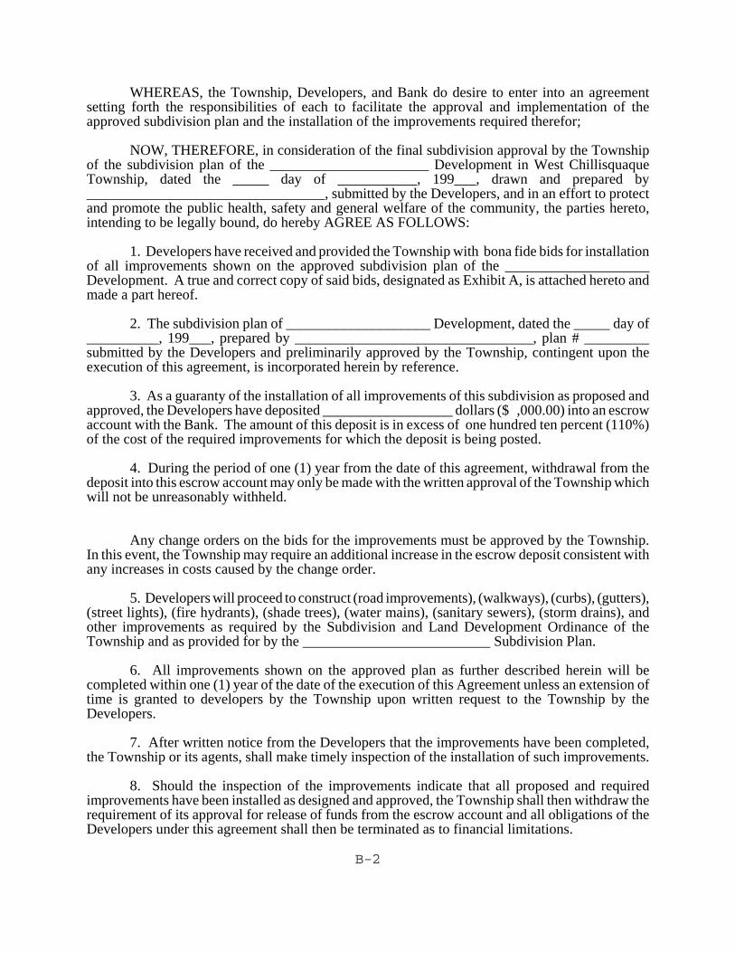
2.4.2 Improvements Guarantee Agreement
2.4.2.1 In lieu of the completion of the improvements required as a condition of finalplan approval, the applicant may file with the Township a fiscal guarantee or animprovements guarantee agreement in the amount of 110% of the cost of theimprovements estimated as of 90 days after the scheduled completion date of theimprovements. The cost of required improvements shall be established by aProfessional Engineer selected by the applicant and shall be submitted to theTownship for approval. The township may utilize the municipal engineer toreview the estimate and choose to reject such estimate for reasonable cause.
2.4.2.2 If the applicant and the Township are unable to agree upon an estimate, then theestimate shall be recalculated and by a Professional Engineer mutually agreedupon by both the Township and the applicant. The estimate certified by thisengineer shall be the final estimate. Fees for the service of this engineer shall bepaid equally by the Township and the applicant.
2.4.2.3 Should the completion of the required improvements require more than one year,the Township may require and increase in the amount of improvements guaranteeby an additional 10% for each year beyond the anniversary date of the originalagreement.
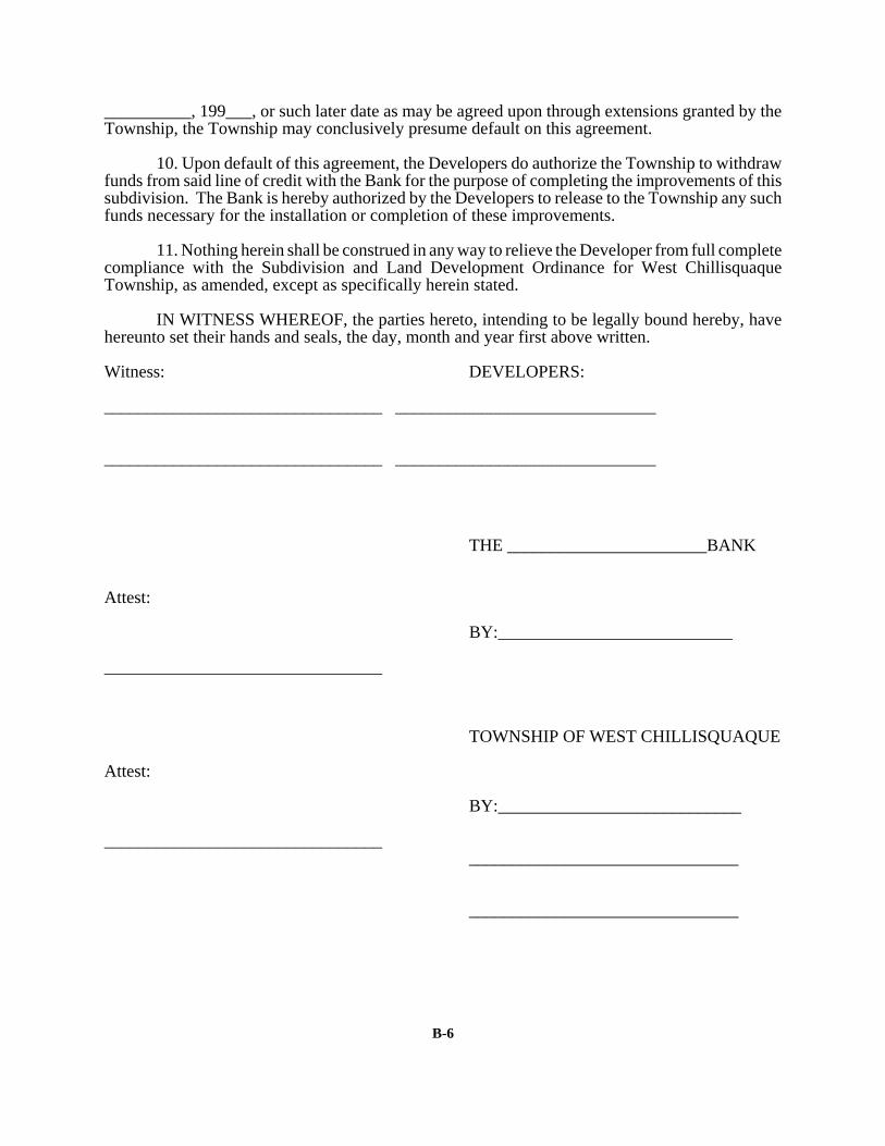
2.4.2.4 The improvements guarantee agree shall be in a form acceptable to theTownship. Bonds, an irrevocable bank letter of credit, or an escrow account aregenerally acceptable types of improvements guarantees.
2-7
2.4.3 Inspection of Improvements
The applicant shall notify the Township Secretary or a designee 48 hours in advance ofthe installation of any required improvements so that a township representative may bepresent to inspect their installation. In the event that the Township fails to perform aninspection after this notification, the inspection procedure stated below shall govern.
2.4.3.1 The Township may authorize the release of a portion of the improvementsguarantee to the applicant necessary for payment to a contractor performing theinstallation of the requirements improvements. In the event that the Townshipdid not inspect the installation of the improvements during construction (seeSection 2.4.3), then it shall have 45 days from receipt of the request to authorizeits engineer to inspect and determine that the improvements covered by theguarantee have been installed satisfactorily.
2.4.3.2 When all necessary improvements have been completed the developer shallnotify the Township in writing by certified or registered mail of the completion.The Township shall, with 10 days after receipt of such notice, authorize aninspection by its engineer of the required improvements. A report shall be madein writing by certified mail to the developer within 30 days of the inspectionauthorization and shall indicate approval or rejection of the requiredimprovements.
2.4.3.3 Upon approval of the completed improvements the Township shall release to thedeveloper those funds remaining in the improvement guarantee including allinterest accrued. Prior to the release of such funds, the developer shall guaranteeto the Township in writing the integrity of the improvements for a period ofeighteen (18) months.
2.4.3.4 If a portion of the completed improvements shall be found unsatisfactory, theengineer's report shall contain a statement of reasons for rejection. Thedeveloper shall proceed to correct or complete those improvements and uponcompletion shall notify the Township in accord with the procedures noted above.
2.4.3.5 Should the Township fail to comply with the time limitations as provided, allimprovements will be deemed to have been approved and the developer shall bereleased from all liability pursuant to the fiscal guarantee agreement.
2.4.4 Dedication of Improvements/Maintenance Guarantee
2.4.4.1 Where the developer proposes to dedicate improvements to the Township, a deedwhich dedicates the land and such improvements to the Township shall berecorded with the final plan.
2.4.4.2 When the Township accepts dedication of all or some of the requiredimprovements, the Township Supervisors may require up to 15% of the actualcost of installation of the improvements for a maintenance guarantee to insure theintegrity of the improvements for a time period not to exceed 18 months from thedate of acceptance of dedication.
2-8
2.4.4.3 The Township may approve a final plan without an offer to dedicate the streetsor other improvements, provided that such improvements are noted as private onthe final plan. The developer shall also be required to provide a notice in eachdeed, lease, or conveyance explaining who has the responsibility for themaintenance of the improvements. See limitations as spelled out in Section4.4.3.
2.5 FINAL PLAN RECORDING
2.5.1 Time Limit for Recording
Upon notification of final plan approval, the subdivider shall record two copies of theapproved plan in the office of the Northumberland County Register and Recorder within90 days after approval. Failure of the subdivider to record the final plan within the 90day period, shall cause the approval of the Township to become null and void unless anextension of time is requested by the subdivider in writing and is granted by theTownship before the expiration date. The final plan shall be filed with theNorthumberland County Register and Recorder before proceeding with the sale of lotsor construction of buildings.
2.5.2 Offer of Dedication
Recording the final plan after approval by the Township has the effect of an irrevocableoffer to dedicate all streets and other public areas to public use. The offer to dedicatestreets, parks, or other areas or portions of them, does not impose any duty upon theTownship concerning maintenance or improvement until the proper authorities of theTownship have made actual appropriation by ordinance or resolution, by entry, orimprovement.
2.6 RESUBDIVISION PROCEDURES
For any replotting or re-subdivision of land, the same procedures and regulations apply asprescribed for an original submission.
3-1
ARTICLE 3
Plan Requirements
3
3.1 GENERAL REQUIREMENTS
All subdivision and land development plans shall meet the requirements outlined in thefollowing sections.
3.2 SKETCH PLAN
A sketch plan should show the following information, legibly drawn, but not necessarily to scaleor showing precise dimensions:
3.2.1 Tract boundaries and location.
3.2.2 Title block, including the name of the owner, municipality, date, and the scale of thedrawing (or the notation - drawing not to scale).
3.2.3 North arrow.
3.2.4 Significant topographic and physical features of the area.
3.2.5 Proposed general street and lot layout, including the acreage of the are to be developedand any data available regarding sewers, septic systems, soil test sites, other utilities, andrights-of-way and easements.
3.2.6 Location sketch of the surrounding area showing roads and significant communityfacilities within 1/2 mile of the proposed subdivision.
3.3 MINOR LAND DEVELOPMENT
In addition to the requirements of Section 3.2 above, a plan for minor land development (seeSection 2.1.2.1) shall meet the following:
3.3.1 The plan shall be drawn at a scale of not more than 100 feet to the inch, and shall be onsheets 18" x 24" or 24" x 36".
3.3.2 Six (6) copies of the plan and two (2) copies of proposed deed restrictions, if any, shallbe submitted.
3-2
3.3.3 The land development plan shall include detailed specifications for streets, sidewalks,parking lots, sewage disposal and water supply, other utilities, storm water facilities, andany other necessary site improvements.
3.3.4 A copy of the required DER Planning Module, if any, or other required certificates orapprovals shall be provided.
3.4 MINOR SUBDIVISION PLAN
The purpose of a Minor Subdivision Plan is to provide for simplified plan requirements whenthe intent of the subdivision is to create Lots fronting on a public road and not involving thecreation of any new streets (see Section 2.1.1.1).
The plan for a Minor Subdivision shall be drawn at a scale of not more than 100 feet to the inch,and shall be on sheets either 18" x 24" or 24" x 36". All plans shall appear on black-on-whiteor blue-on-white prints. Six (6) copies of the final mitted.
3.4.1 A plan for a Minor Subdivision shall show:
3.4.1.1 Title block containing the name of the subdivision, municipality in whichlocated, name and address of the subdivider, date, and scale.
3.4.1.2 Name and address and certification, with seal, of the registeredprofessional engineer or surveyor preparing the final plan survey andmap.
3.4.1.3 North arrow.
3.4.1.4 Tract map showing the relationship of the proposed development to theentire tract.
3.4.1.5 Location map showing relation of tract to adjoining properties, relatedroad and highway system, municipal boundaries, and communityfacilities within a minimum of 1/2 mile from the proposed subdivision.
3.4.1.6 Names of the owners on all adjoining property and the names of allabutting subdivisions.
3.4.1.7 The location of prominent topographic features such as streams,wetlands, drainage channels, floodplain, wooded areas and otherpertinent features that may influence the design. The 100 year floodelevation shall be shown where available from the Township's FloodInsurance Study.
3.4.1.8 Soil types and soil boundaries (for more information contact the
3-3
Northumberland County Conservation District).
3.4.1.9 Existing buildings, sewers, water lines, and culverts, transmission lines,fire hydrants, and other significant man-made features.
3.4.1.10 Deep probe and soil percolation test sites, if on-lot sewage facilities areproposed.
3.4.1.11 All existing or recorded streets on or adjacent to the tract, including nameor number, right-of-way width and width of pavement.
3.4.1.12 Bearings to the nearest second and dimensions to the nearest 100th of afoot for existing and proposed boundaries, lot lines, streets, rights of way,and easements, and any other areas to be dedicated to the public use.Also to be shown are street names, building setback lines, total acreageof the entire tract, total number of lots or dwelling units, a consecutive lotnumbering system, zoning classification, and the area of each lot insquare feet. All survey areas shall close with an error not exceeding one(1) foot in 10,000 feet.
3.4.1.13 A notation that states that a PennDOT Highway Occupancy Permit isrequired prior to the construction of a driveway onto a state highway.
3.4.1.14 Affidavit or certificate of ownership with all appropriate signatures anddated prior to submission.
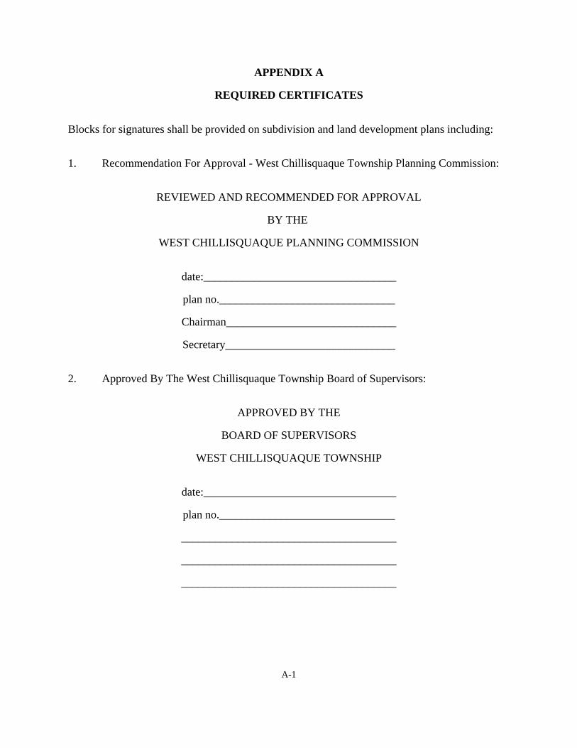
3.4.1.15 Block for signatures of the chairperson and secretary of the WestChillisquaque Planning Commission indicating recommended action ofthe Commission and for signatures of the West Chillisquaque TownshipBoard of Supervisors indicating approval of the plan (see Appendix A).
3.4.1.16 Location and material of all permanent monuments and lot markers.
3.4.2 The following information, data, and documents shall be submitted as appropriate withthe plan for a Minor Subdivision:
3.4.2.1 Completed application form and plan review fee.
3.4.2.2 Copies of proposed deed restrictions, if any.
3.4.2.3 A sewage facilities plan and required documentation as specified inSection 4.15 of this Ordinance.
3-4
3.5 ADD-ON SUBDIVISION PLAN
The purpose of an Add-On Subdivision Plan is to provide for simplified plan requirements whenthe intent of the subdivision is to create a lot to be added to an existing contiguous lot and whenno new building lots or land development is proposed (see Section 2.1.1.2).
The Add-On plan shall be drawn at a scale of not more than 100 feet to the inch, and shall be onsheets either 18" x 24" or 24" x 36". All plans shall appear on black-on-white or blue-on-whiteprints. Six (6) copies of the final plan shall be submitted.
3.5.1 An "add-on" subdivision plan shall show:
3.5.1.1 Title block containing the name of the subdivision, municipality, tractowner, date, scale, and the name and profession of the individualpreparing the plan.
3.5.1.2 North indicator.
3.5.1.3 Location map showing relation of tract to adjoining properties, relatedroad and highway system, and municipal boundaries.
3.5.1.4 Tract map showing the relationship of the proposed lot to the entire tractand to the contiguous lot.
3.5.1.5 Names of the owners on all adjoining property.
3.5.1.6 Certification and seal of a professional land surveyor to the effect that thesurvey and map are correct.
3.5.1.7 Bearings to the nearest second and dimensions to the nearest 100th of afoot for existing boundaries, proposed lot lines, building setback lines,zoning classification, and the area of each lot in square feet. Allsurveyed areas shall close with an error not exceeding one (1) foot in tenthousand (10,000) feet.
3.5.1.8 The location of all required monuments (see Section 4.12).
3.5.1.9 Affidavit or certificate of ownership with all appropriate signatures anddated upon submission.
3.5.1.10 Block for signatures of the chairperson and secretary of the WestChillisquaque Planning Commission indicating recommended action ofthe Commission and for signatures of the West Chillisquaque TownshipBoard of Supervisors indicating approval of the plan (see Appendix A).
3-5
3.5.1.11 A notation stating that: "This lot is an addition to existing land of recordof Grantee as recorded in Deed Book ________Page _______. Bothparcels to be considered as one for future subdivision, land transfers, landdevelopment, and/or building purposes."
3.5.1.12 In lieu of evidence of a sewage permit, SEO feasibility report, or accessto central sewerage, it shall be noted on the subdivision plan, that: Apermit for sewage disposal has been neither requested nor granted for thislot. The Grantee, his heirs and assigns, accept the responsibility forobtaining a permit for sewage facilities if, and at the time, same arenecessary.
3.5.2 The following information, data, and documents shall be submitted as appropriate withthe Add-On plan:
3.5.2.1 Completed application form and plan review fee.
3.5.2.2 Copies of proposed deed restrictions, if any.
3.6 PRELIMINARY PLAN - MAJOR SUBDIVISION AND MAJOR LANDDEVELOPMENT
The subdivider shall file six (6) copies of the preliminary plan and two (2) copies of the otherrequired material along with the West Chillisquaque Subdivision And Land DevelopmentReview Application Form with the Township Secretary. The copies of the preliminary plan shallbe either black and white or blue and white prints, and the sheet size shall be no small than 18"x 24" and no larger than 24" x 36".
3.6.1 Scale
The preliminary plan shall be drawn at a scale of 1" = 50' or 1" = 100'.
3.6.2 Information To Be Shown On Preliminary Plan
3.6.2.1 Title block containing the name of the subdivision, municipality in whichlocated, date, scale, address, and name of owner or subdivider, and nameof individual preparing the plan.
3.6.2.2 North arrow.
3.6.2.3 Location map showing relation of proposed subdivision to adjoiningproperties, related road and highway system, municipally boundaries, andcommunity facilities within at least 1/2 mile of the proposed subdivision.
3.6.2.4 Tract map showing the relationship of the proposed development to theentire tract.
3-6
3.6.2.5 Names of owners of all adjoining property and names of all abuttingsubdivisions.
3.6.2.6 Existing and proposed topographic contours at vertical intervals of two(2) feet or five (5) feet and datum and bench marks to which contourelevations refer; contours at a two (2) foot interval may be required onlevel terrain or for intensive development projects. The Township maywaive the contour requirement in low density developments involving noroads or utilities and where a site inspection provides adequateinformation for action on the plan.
3.6.2.7 Soil types and soil boundaries (for more information contact theNorthumberland County Conservation District).
3.6.2.8 The location of prominent topographic features such as streams,wetlands, drainage channels, floodplains, wooded areas and otherpertinent features that may influence the design. The 100 year floodelevation shall be shown where available from the Township's FloodInsurance Study.
3.6.2.9 Existing buildings, sewers, water mains, culverts, power transmissionlines, oil and gas pipelines, fire hydrants, and other significant man-madefeatures.
3.6.2.10 All existing or recorded streets on or adjacent to the tract, including nameor number, right-of-way width and width of pavement.
3.6.2.11 Deep probe and soil percolation test sites, if on-lot sewage facilities areproposed.
3.6.2.12 Total acreage, number of lots, average lot size, and existing zoningclassification.
3.6.2.13 Location and width of proposed streets, rights-of-way, and easements;proposed lot lines; and areas to be dedicated to public use.
3.6.2.14 Block for signatures of the chairperson and secretary of the WestChillisquaque Planning Commission indicating recommended action ofthe Commission and for signatures of the West Chillisquaque TownshipBoard of Supervisors indicating approval of the plan (see Appendix A).
3-7
3.6.2.15 Preliminary plans shall include the full plan of the development, showingthe location of all proposed streets, rights-of-way, easements, publicareas including parks and playgrounds, proposed sewer and waterfacilities, proposed lot lines with bearings and dimensions, lot numbersand/or block numbers in consecutive order, and proposed buildingsetback lines for each street.
3.6.2.16 Certification and seal of a professional land surveyor to the effect that thesurvey and map are correct.
3.6.2.17 Multi-family, commercial, and industrial land developments shall showbuilding locations, driveways, internal streets, parking areas, loadingareas, landscaped areas, outdoor recreation facilities, sidewalks andpathways, utilities, and storm water management facilities in addition tothe above information.
3.6.2.18 All areas, streets, facilities, etc. proposed to be dedicated for future publicuse, together with the conditions of such dedications or reservations shallbe shown.
3.6.3 Material To Be Submitted With The Preliminary Plan
The following information, data, and documents shall be submitted with the preliminaryplan:
3.6.3.1 Subdivision application form.
3.6.3.2 Copies of proposed deed restrictions if any.
3.6.3.3 Tentative cross-sections and center-line profiles for each proposed street.
3.6.3.4 Preliminary designs of proposed bridges or culverts.
3.6.3.5 A sewage facilities plan and required documentation as specified inSection 4.15 of this Ordinance.
3.6.3.6 A water facilities plan and required documentation as specified in Section4.16 of this Ordinance.
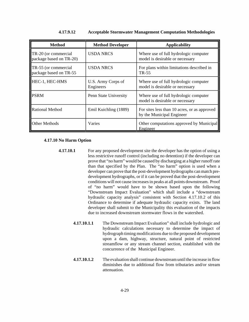
3.6.3.7 A storm water management plan in accord with Section 4.17 of thisOrdinance.
3.6.3.8 Sketch of proposed street layout for the remainder of the tract where thepreliminary plan covers only part of the subdivider's holdings.
3-8
3.6.3.9 An indication from the Municipality or the Union CountyCommunications Center that proposed street names do not duplicate anynow in use.
3.6.3.10 Estimated costs of required improvements.
3.6.3.11 An erosion and sedimentation control plan (and permit, if required) inaccord with Title 25, Chapter 102 of the rules and regulations of theDepartment of Environmental Resources, as amended. For moreinformation contact the Northumberland County Conservation District.
3.6.3.12 If any portion of a development project is in a floodplain area, thendocumentation shall be submitted indicating compliance with pertinentlaws and regulations of the Township and the Pennsylvania DER;
3.6.3.13 If any alteration, excavation, or relocation of a watercourse is proposed,a copy of the DER permit shall be submitted. For more informationcontact the Northumberland County Conservation District.
3.6.3.14 If a subdivision of 25 or more lots or a land development generating morethan 200 vehicles per day, a natural features analysis shall be providedin accord with Section 4.21 of this Ordinance.
3.6.3.15 If a subdivision of 25 or more lots or a land development generating morethan 200 vehicles per day a Community Impact Analysis shall beprovided in accord with Section 4.22 of this Ordinance.
3.6.3.16 When the land included in the proposed subdivision has a natural gaspipeline, a petroleum or petroleum products pipeline, or a powertransmission line located thereon, the application shall be accompaniedby a letter from the owner of such pipeline or transmission line statingthe minimum set-back distance requirements from such pipeline ortransmission line.
3.7 FINAL PLAN - MAJOR SUBDIVISION AND MAJOR LAND DEVELOPMENT
The subdivider or developer shall submit six (6) copies of the final plan and two (2) copies ofother required materials to the Township Secretary. The copies of the final plan shall be eitherblack and white or blue and white prints with a sheet size which is no smaller than 18" x 24" andno larger than 24" x 36". If the final plan is drawn in two or more sections, a key map showingthe location of the sections shall be placed on each sheet.
3-9
3.7.1 Scale
The final plan shall be drawn at a scale of 1" = 50' or 1" = 100'.
3.7.2 Information To Be Shown On Final Plan
3.7.2.1 Title block containing the name of the subdivision, municipality in whichlocated, name and address of the subdivider, date, and scale.
3.7.2.2 Name and address and certification, with seal, of the registeredprofessional engineer or surveyor preparing the final plan survey andmap.
3.7.2.3 North arrow.
3.7.2.4 Tract map showing the relationship of the proposed development to theentire tract.
3.7.2.5 Location map showing relation of tract to adjoining properties, relatedroad and highway system, municipal boundaries, and communityfacilities within a minimum of 1/2 mile from the proposed subdivision.
3.7.2.6 Existing and proposed contours at vertical intervals of five (5) feet or lessand benchmark to which contour elevations refer. Contours at a two (2)foot interval may be required on level terrain or for intensivedevelopment projects. The Township may waive the contourrequirement in low density developments involving no roads or utilitiesand where a site inspection provides adequate information for action onthe plan.
3.7.2.7 Names of the owners on all adjoining property and the names of allabutting subdivisions.
3.7.2.8 The location of prominent topographic features such as streams,wetlands, drainage channels, floodplains, wooded areas and otherpertinent features that may influence the design. The 100 year floodelevation shall be shown where available from the Township's FloodInsurance Study.
3.7.2.9 Soil types and soil boundaries (for more information contact theNorthumberland County Conservation District).
3.7.2.10 Existing buildings, sewers, water lines, and culverts, transmission lines,fire hydrants, and other significant man-made features.
3-10
3.7.2.11 Deep probe and soil percolation test sites, if on-lot sewage facilities areproposed.
3.7.2.12 All existing or recorded streets on or adjacent to the tract, including nameor number, right-of-way width and width of pavement.
3.7.2.13 Bearings to the nearest second and dimensions to the nearest 100th of afoot for existing and proposed boundaries, lot lines, streets, rights of way,and easements, and any other areas to be dedicated to the public use.Also to be shown are street names, building setback lines, total acreageof the entire tract, total number of lots or dwelling units, a consecutive lotnumbering system, zoning classification, and the area of each lot insquare feet. All survey areas shall close with an error not exceeding one(1) foot in 10,000 feet.
3.7.2.14 A notation that states that a Penndot Highway Occupancy Permit isrequired prior to the construction of a driveway onto a state highway.
3.7.2.15 All corrected and updated material from the preliminary plan.
3.7.2.16 Affidavit or certificate of ownership with all appropriate signatures anddated prior to submission.
3.7.2.17 Block for signatures of the chairperson and secretary of the WestChillisquaque Planning Commission indicating recommended action ofthe Commission and for signatures of the West Chillisquaque TownshipBoard of Supervisors indicating approval of the plan (see Appendix A).
3.7.2.18 Location and material of all permanent monuments and lot markers.
3.7.3 Material To Be Submitted With Final Plan
3.7.3.1 Subdivision application form if different from application previouslysubmitted.
3.7.3.2 Restrictions of all types which will run with the land and becomecovenants in the deeds of lots within the subdivision.
3.7.3.3 All covenants running with the land governing the reservation andmaintenance of dedicated or undedicated land or open space.
3.7.3.4 Final cross-sections and center-line profiles for each proposed street.
3.7.3.5 Final designs for proposed bridges and culverts.
3.7.3.6 A sewage facilities plan and required documentation as specified in
3-11
Section 4.15 of this Ordinance.
3.7.3.7 A water facilities plan and required documentation as specified in Section4.16 of this Ordinance.
3.7.3.8 A storm water management plan in accord with Section 4.17 of thisOrdinance.
3.7.3.9 All revised and corrected material from the preliminary plan.
3.7.3.10 Copies of deeds of dedication of improvements to the Township.
3.7.3.11 An erosion and sedimentation control plan (and permit, if required) inaccord with Title 25, Chapter 102 of the rules and regulations of theDepartment of Environmental Resources, as amended. If theimprovements have been installed then a written verification shall berequired from the Northumberland County Conservation District that theerosion and sedimentation control measures have been implemented.
3.7.3.12 If any portion of a development project is in a floodplain area, thendocumentation shall be submitted indicating compliance with pertinentlaws and regulations of the Township and Pennsylvania Department ofEnvironmental Resources.
3.7.3.13 If any alteration or relocation of a watercourse is proposed, a copy of theDER permit shall be submitted.
3.7.3.14 If improvements are required in the development, then one of thefollowing requirements shall be met:
3.7.3.14.1 A written acknowledgement shall be obtained from the TownshipEngineer that the improvements have been inspected and installedin accord with the approved preliminary plan; or
3.7.3.14.2 An improvements guarantee agreement shall be executed betweenthe Township Supervisors, the developer, and a financialguarantee agent. The improvements guarantee agreement shallbe in a form acceptable to the Township. Bonds, a irrevocablebank letter of credit, or an escrow account are generallyacceptable types of improvements guarantees. See Section 2.4.
4-1
ARTICLE 4
Subdivision Design and Construction Standards
4.1 MINIMUM STANDARDS
4.1.1 The standards outlined in this section shall be applied by the Township in evaluating plansfor proposed subdivisions. The standards outlined herein shall be considered to be minimumstandards, and the Township may require more restrictive standards. Whenever municipalor other applicable regulations impose more restrictive standards, such other regulations shallcontrol.
4.1.2 The location of the subdivision shall conform to the West Chillisquaque ComprehensivePlan, and the use of land in the subdivision shall conform to the West Chillisquaque ZoningOrdinance.
4.2 GENERAL STANDARDS
The following requirements and guiding principles for subdivision and land development shall beobserved by all developers.
4.2.1 Land Suitability: Land subject to flooding and all land deemed by the Township to beuninhabitable because of other hazards to life, health, or property, (such as improperdrainage, steep slopes, rock formations or topography, or utility easements or rights-of-way)shall not be plotted for residential occupancy, nor for such other uses as may increase dangerto health, life, or property, or aggravate the flood hazard; but such land within an area forwhich a subdivision plan is developed shall be set aside for such uses as will not beendangered by periods of occasional flooding or will not result in unsatisfactory livingconditions.
4.2.2 Municipal Boundaries: Lot lines shall, where possible, follow municipal and countyboundary lines rather than cross them.
4.3 STREET CLASSIFICATION SYSTEM
4.3.1 Arterial Street
A street serving a large volume of comparatively high speed and long distance traffic,including all streets classified as arterial streets in the West Chillisquaque TownshipComprehensive Plan. Route 147 is an example of an arterial street in West ChillisquaqueTownship.
4.3.2 Collector Street
A street which, in addition to providing access to abutting properties, intercepts minor streetsto provide a route to arterial streets. Collector streets are so designated in the WestChillisquaque Township Comprehensive Plan. Route 45, Route 405, and Housels Run Roadare examples of collector streets in West Chillisquaque Township.
4-2
4.3.3 Minor Street
Streets within subdivisions and developments, including marginal access streets and cul-de-sac streets, and streets which serve rural areas, which are designed to afford primary accessto abutting property.
4.4 OWNERSHIP AND MAINTENANCE OF STREETS
4.4.1 The State Highway System includes all public streets and highways maintained by thePennsylvania Department of Transportation.
4.4.2 The Township Road Network includes all public streets and roads maintained by theTownship. A subdivider proposing dedication of streets or roads to the Township shallsubmit road plans and specifications that meet or exceed the minimum requirements of thisordinance. A deed of dedication shall be recorded with the final plan in all cases whereroads are to be dedicated to the Township.
4.4.3 Private streets shall include all streets not dedicated or maintained as part of the StateHighway System or the Township Road Network. Private streets, including internal streetsserving mobile home parks, townhouse and multi family housing developments, commercialand industrial parks and recreational vehicle park and campground developments, may onlybe permitted under the following conditions:
4.4.3.1 The plan shall show a notation regarding the private nature of the street and right-of-way.
4.4.3.2 Private streets shall be constructed in accord with the design standards of Section4.5 and the construction standards of Section 4.7.
4.4.3.3 The subdivider shall provide for inclusion in the deed or lease a Maintenance andUse Agreement indicating maintenance responsibilities for the private street. Boththe responsibilities of the buyer or lessee and the subdivider shall be indicated.
4.4.3.4 In the event that the access to a proposed subdivision or development is along anexisting private right-of-way, the subdivider shall furnish a Maintenance and UseAgreement for both the existing right-of-way users and the proposed users of thecontemplated development. This agreement shall be recorded with the final planand shall describe right-of-way width and location and maintenance responsibilitiesof all the parties involved.
4.5 STREET DESIGN STANDARDS
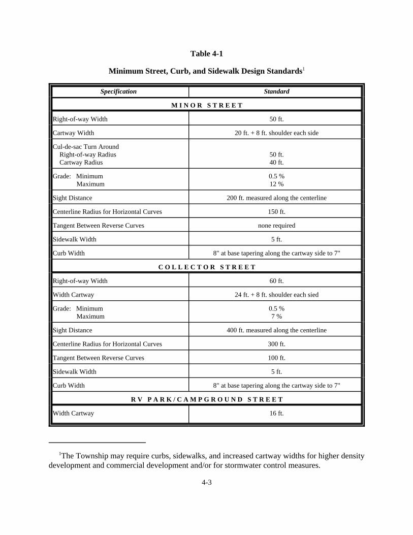
4.5.1 Minimum Street, Curb, and Sidewalk Design Standards
Minimum design standards are found in Table 4-1. Exceptions to the standards and detailscovering unique situations are included below.
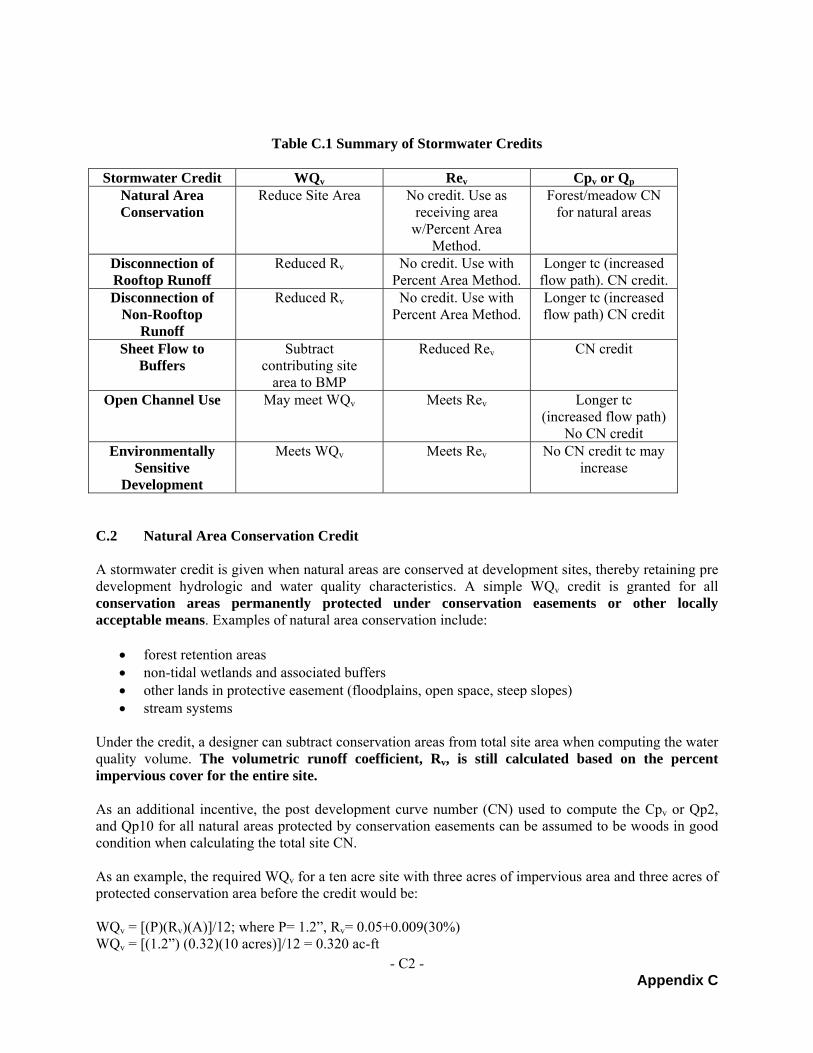
1The Township may require curbs, sidewalks, and increased cartway widths for higher densitydevelopment and commercial development and/or for stormwater control measures.
4-3
Table 4-1
Minimum Street, Curb, and Sidewalk Design Standards1
Specification Standard
M I N O R S T R E E T
Right-of-way Width 50 ft.
Cartway Width 20 ft. + 8 ft. shoulder each side
Cul-de-sac Turn Around Right-of-way Radius Cartway Radius
50 ft.40 ft.
Grade: Minimum Maximum
0.5 %12 %
Sight Distance 200 ft. measured along the centerline
Centerline Radius for Horizontal Curves 150 ft.
Tangent Between Reverse Curves none required
Sidewalk Width 5 ft.
Curb Width 8" at base tapering along the cartway side to 7"
C O L L E C T O R S T R E E T
Right-of-way Width 60 ft.
Width Cartway 24 ft. + 8 ft. shoulder each sied
Grade: Minimum Maximum
0.5 %7 %
Sight Distance 400 ft. measured along the centerline
Centerline Radius for Horizontal Curves 300 ft.
Tangent Between Reverse Curves 100 ft.
Sidewalk Width 5 ft.
Curb Width 8" at base tapering along the cartway side to 7"
R V P A R K / C A M P G R O U N D S T R E E T
Width Cartway 16 ft.
4-4
4.5.2 Right-of-Way
4.5.2.1 Where a subdivision or development abuts or contains an existing street ofinadequate right-of-way width, additional or future right-of-way width may berequired in accord with Table 4-1. However, if the development abuts only one sideof the road the subdivider shall be required to provide only one-half of the additionalright-of-way, if required.
4.5.2.2 Where a subdivision or development abuts or contains an existing street or road onthe state highway system, the Pennsylvania Department of Transportation shallmake a recommendation concerning necessary additional right-of-way width of thestate road and minimum building setback from the state road. Any additional right-of-way width required to correct existing problems or to allow necessaryimprovements shall be reserved on the plan but dedication of this additional right-of-way will not be required for plan approval. Building setback lines shall be measuredfrom this required ultimate street right-of-way line.
4.5.2.3 Additional street right-of-way may be required by the Township for public safetyand convenience, for acceleration or deceleration lanes into parking lots or streets,and in high density residential developments.
4.5.3 Cul-De-Sac Streets
4.5.3.1 Cul-de-sac streets permanently designed as such shall be provided with a turnaroundin accord with Table 4-1. They shall not exceed 1200 feet in length or provideaccess to more than 20 dwelling units. In instances where the Township agrees tomodify either of these requirements due to terrain conditions, an intermediateturnaround with a center island to guide traffic may be required.
4.5.3.2 A temporary all weather turnaround shall be provided for all dead end streets thatprovide access to future development on adjacent tracts of land. This turnaroundshall as a minimum be constructed in accord with the subbase and basespecifications for a local street.
4.5.3.3 Innovative alternatives to the standard circular turnaround may be permitted by theTownship where equivalent area for a turnaround in accord with Table 4-1 isprovided. The use of an innovative alternative may jeopardize the eligibility forPennDOT Liquid Fuels Tax reimbursement for the cul-de-sac street.
4.5.4 Street System Layout
4.5.4.1 Streets shall be laid out to conform as much as possible to the topography, to permitefficient drainage and utility systems, and to require the minimum number of streetsnecessary to provide convenient and safe access to property.
4.5.4.2 Minor streets shall be laid out to discourage through traffic, although provisions forstreet connections into and from adjacent areas will generally be required.
4-5
4.5.4.3 Alleys shall not be permitted in residential subdivisions.
4.5.4.4 If the lots in a development are large enough for re-subdivision, or if a portion of thetract is not subdivided, adequate street right-of-way to permit further subdivisionshall be provided as necessary.
4.5.4.5 Where a subdivision or land development abuts a major collector or arterial street,the Township may require an internal street system, marginal access street, rearservice street, reverse frontage lots, or such other treatment as will provideprotection for abutting properties, reduction in the number of intersections anddriveways with the major or arterial street, and separation of local and throughtraffic. Direct driveway access to SR 0045 and SR 0147 shall be prohibited.
4.5.4.6 Proposed streets shall conform to the Official Map of the Township, if such a maphas been adopted in accord with Article IV of Act No. 170 of 1988, as amended.
4.5.5 Street Intersections
4.5.5.1 Minor and collector streets shall not intersect with collector and arterial streets atintervals of less than 800 feet as measured between their centerline.
4.5.5.2 Streets entering opposite sides of another street shall be laid out either directlyopposite one another or with a minimum offset of 150 feet as measured betweentheir centerline.
4.5.5.3 Intersections involving the junction of more than two streets shall be prohibited.
4.5.5.4 Streets shall be laid out to intersect as nearly as possible at right angles. No minorstreet shall intersect another at an angle of less than sixty (60) degrees. Thisstandard shall be increased to seventy five (75) degrees for the intersection of aminor street with either a collector street or with a street on the State HighwaySystem.
4.5.5.5 Minimum curb radius at the intersection of two minor streets shall be at least twenty(20) feet; and minimum curve radius at an intersection of a minor street and acollector or arterial street shall be at least twenty-five (25) feet.
4.5.5.6 Clear site triangles shall be maintained in accord with the schedule below for thedifferent street classifications, and as measured along the centerline from the pointof intersection. No significant obstructions or plantings higher than thirty (30)inches above the road surface or tree limbs lower than eight (8) feet shall bepermitted within this area.
4.5.6.1 All streets shall be provided with a leveling area having a grade of four (4) percentor less for a distance of 25 feet measured from the edge of the shoulder or curb ofthe intersecting street.
4.5.6.2 Vertical curves shall be required at changes of grade exceeding one (1) percent.
4.5.6.3 Whenever street lines are deflected in excess of five (5) degrees, connection shallbe made by horizontal curves.
4.5.6.4 The grade of a street cross section measured from the crown shall be within thelimits of 1/4 inch to 3/8 inch per foot. Shoulder cross-slopes shall be 3/4 inch perfoot.
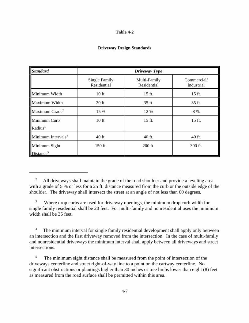
4.6 DRIVEWAY DESIGN STANDARDS
4.6.1 Proposed lots or land developments shall be laid out in relation to public and private streetsso that safe driveway access can be provided in accord with Table 4-2.
4.6.2 Plans for proposed lots or land developments requiring access to the State Highway Systemshall contain a notice that a highway occupancy permit is required pursuant to Section 420of the Act of June 1, 1945 (P.L. 1242, No. 428), known as the "State Highway Law," beforedriveway access to the state highway is permitted.
4.7 STREET CONSTRUCTION STANDARDS
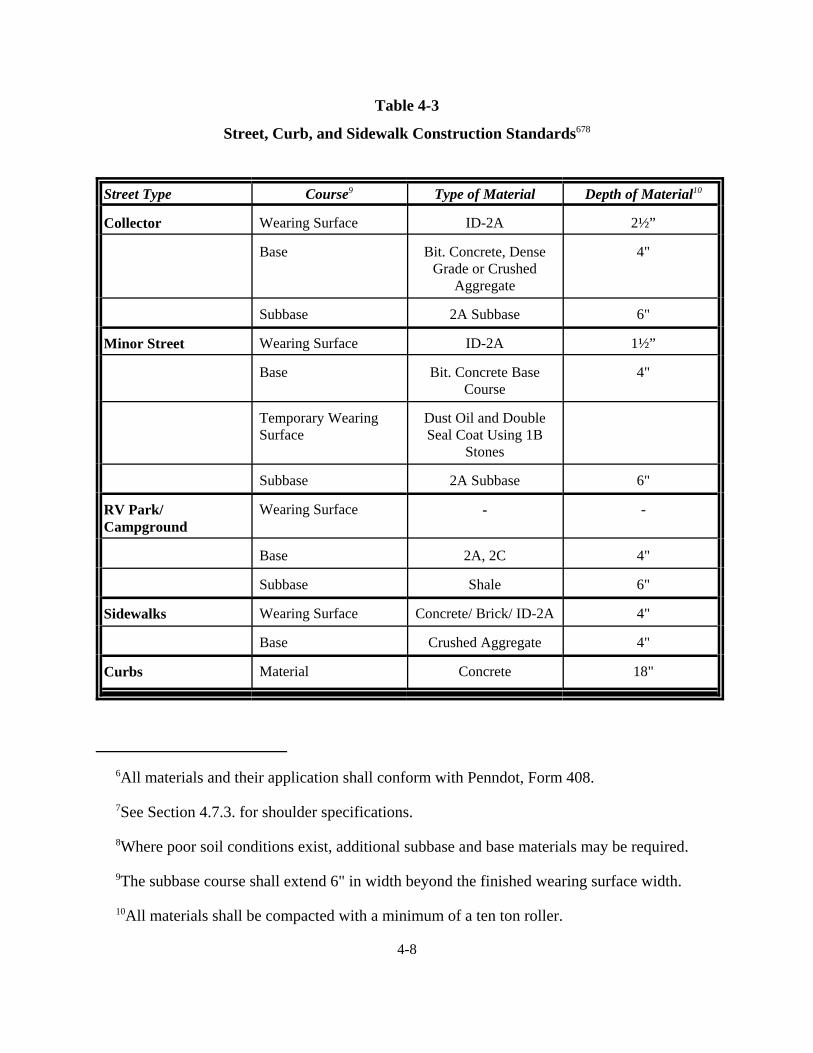
4.7.1 New Streets
Streets shall be built in accord with the subdivision plan approved by the township. Theconstruction standards of Table 4-3 shall govern unless the township requires more stringentstandards due to adverse soils or other conditions.
4.7.2 Existing Private Street
Existing private streets shall be upgraded to the standards of the subdivision ordinance(including Tables 4-1 and 4-3) when being utilized as access to a proposed subdivision orland development.
4.7.3 Road Shoulders
Road shoulders, if required, shall be constructed of either 2A "subbase" or 2RC material inaccord with PennDOT 408 specifications. This material shall be compacted to the depth ofthe road base and wearing surface combined and shall have a cross slope in accord withSection 4.5.6.4.
2 All driveways shall maintain the grade of the road shoulder and provide a leveling areawith a grade of 5 % or less for a 25 ft. distance measured from the curb or the outside edge of theshoulder. The driveway shall intersect the street at an angle of not less than 60 degrees.
3 Where drop curbs are used for driveway openings, the minimum drop curb width forsingle family residential shall be 20 feet. For multi-family and nonresidential uses the minimumwidth shall be 35 feet.
4 The minimum interval for single family residential development shall apply only betweenan intersection and the first driveway removed from the intersection. In the case of multi-familyand nonresidential driveways the minimum interval shall apply between all driveways and streetintersections.
5 The minimum sight distance shall be measured from the point of intersection of thedriveways centerline and street right-of-way line to a point on the cartway centerline. Nosignificant obstructions or plantings higher than 30 inches or tree limbs lower than eight (8) feetas measured from the road surface shall be permitted within this area.
4-7
Table 4-2
Driveway Design Standards
Standard Driveway Type
Single FamilyResidential
Multi-FamilyResidential
Commercial/Industrial
Minimum Width 10 ft. 15 ft. 15 ft.
Maximum Width 20 ft. 35 ft. 35 ft.
Maximum Grade2 15 % 12 % 8 %
Minimum Curb
Radius3
10 ft. 15 ft. 15 ft.
Minimum Intervals4 40 ft. 40 ft. 40 ft.
Minimum Sight
Distance5
150 ft. 200 ft. 300 ft.
6All materials and their application shall conform with Penndot, Form 408.
7See Section 4.7.3. for shoulder specifications.
8Where poor soil conditions exist, additional subbase and base materials may be required.
9The subbase course shall extend 6" in width beyond the finished wearing surface width.
10All materials shall be compacted with a minimum of a ten ton roller.
4-8
Table 4-3
Street, Curb, and Sidewalk Construction Standards678
Street Type Course9 Type of Material Depth of Material10
4.8.1 Sidewalks and/or curbs, if required, shall be constructed of portland cement concrete, equalto, or higher in quality, than Class A concrete, in accord with Table 4-3 and PennDOT Form408 specifications, as amended. Sidewalks may also be constructed with a wearing surfaceof brick or ID-2A material. Compliance with the Township's Curb and Sidewalk Ordinance,if any, shall also be required.
4.8.2 Sidewalks shall be installed in subdivisions where two-family dwellings, townhouses, ormultiple family dwellings are planned, or where lot widths are less than eighty (80) feet orwhere the subdivision abuts areas which have existing sidewalks. Sidewalks may also berequired to provide access to community facilities such as schools, shopping centers, orrecreation areas if the Planning Commission deems that a hazard would exist without them.
4.8.3 Whenever sidewalks are constructed or repaired, provisions shall be made to facilitatehandicapped accessibility.
4.8.4 No trees or shrubs shall be permitted in the street right-of-way.
4.9 BLOCKS
4.9.1 Blocks shall be a maximum of 1,600 feet in length, although the township may grant awaiver to this requirement in the event of unusual topographic conditions.
4.9.2 Blocks shall have sufficient widths to provide for two (2) tiers of lots of appropriate depths.Exceptions to this prescribed block width shall be permitted in blocks adjacent to arterialstreets, railroads, or waterways.
4.9.3 In large blocks with interior parks or playgrounds, in exceptionally long blocks where accessto a school, shopping center, or to any other facility is necessary, or where cross streets areimpractical or unnecessary, a crosswalk with a minimum right-of-way of twelve (12) feetwith a minimum surfaced width of five (5) feet may be required by the PlanningCommission.
4.10 FLAG LOT
May be allowed where warranted by physical conditions of land form, relative isolation of the lot,existing lot pattern or unusual size or shape of parcels. A flag lot shall only be considered in accordwith the Waiver or Modification procedures of this ordinance (Section 1.7.1) and in accord with thefollowing criteria:
4.10.1 The narrow strip of land known as the "flag pole" portion of the lot which provides theconnection between the lot and the public street shall be a minimum of 20 ft. in width;
4.10.2 The "flag pole" portion of the lot shall be platted with the lot;
4.10.3 The lot area standards for the flag lot shall be the same as for the zoning district in which thelot is to be situated, except that the "flag pole" portion of the lot shall not be included for the
4-10
purpose of calculating the minimum lot area;
4.10.4 The "flag pole" access to the lot shall be improved to a mud free and passable conditionbased upon a minimum construction specification including: width - 12 ft.; subbase course -6" of shale; base course - 4" of 2A or 2RC. The specification shall also be indicated on thesubdivision plan for the flag lot. The "flag pole" shall not cross a live stream, ravine, ditch,or similar topographic feature without provision of an adequate structure or fill and culvert,according to standards established by the township.
4.11 LOT SIZE AND BUILDING SETBACK LINES
Minimum lot sizes and building setback lines for the township are found in the township zoningcode. Dimensional requirements for special types of land development are also found in Article 6of this Ordinance.
4.12 MONUMENTS
Monuments shall be solid steel, copper, or brass bars at least 30" x 1/2" diameter and shall be set atall newly established points where lines or lines and curves intersect. Survey caps and undergroundmagnetic markers may also be utilized in conjunction with bars used for monuments.
In subdivisions of 10 lots or greater, a minimum of two permanent reference monuments shall beestablished in the external boundary of the subdivision where the bar is set in concrete at least 6" x6" x 30".
4.13 EASEMENTS
4.13.1 Utility Easements
The width and location of utility easements shall be as specified by the particular utilitycompany. To the maximum extent possible easements shall be centered on or locatedadjacent to side or rear property lines or adjacent to the street right-of-way in the front yard.If feasible, utility easements may also be located within the street right-of-way.
4.13.2 Drainage Easements
Where a subdivision or land development is traversed by a water course, drainage way,channel, or stream, there shall be provided a drainage easement conforming substantiallywith the line of such watercourse, drainage way, channel, or stream and of such width as willbe adequate to preserve the unimpeded flow of natural drainage without damaging adjacentproperty.
Drainage easements shall also be provided for the maintenance and protection of stormsewers and other storm water management facilities. Easements shall permit necessarypublic or private channel maintenance or improvement work and access of equipment, andshall prohibit buildings or other permanent structures. Maintenance responsibilities forprivate easements shall be provided in accord with Section 2.4.4.3. of this ordinance.
4-11
4.14 UTILITIES
Utilities including electric, telephone, and cable television shall be installed underground in accordwith the PA Underground Utilities Act No. 287 of 1974. Underground utilities are not required forany of the following situations:
4.14.1 For a residential subdivision of less than five (5) lots bordering an existing street which ispresently served by overhead utility service;
4.14.2 For service to a commercial or industrial development;
4.14.3 For a project where a variance under Act 287 has been granted by the Pennsylvania PublicUtility Commission.
4.15 SEWAGE FACILITIES
4.15.1 Sewage Disposal Method
Subdivisions shall be connected to a public sewer system in accord with the requirementsof the Township Municipal Authority and the Pennsylvania Department of EnvironmentalResources unless connection is not feasible. The Township may permit the followingalternatives listed in order of preference:
4.15.1.1 Connection to a private sewer system designed and constructed by thedeveloper in accord with the requirements of the Pennsylvania Departmentof Environmental Resources.
4.15.1.2 Utilization of on lot sewage disposal facilities in accord with therequirements of the Pennsylvania Department of Environmental Resources.
4.15.2 Sewage Planning Requirements
The developer shall submit documentation with the preliminary plan application that verifiesTownship Municipal Authority or Township Sewage Enforcement Officer approval of theproposed sewage disposal method. Additional documentation shall be provided that verifiesPennsylvania Department of Environmental Resources approval.
4.15.2.1 10 Lots or Less Utilizing On-Lot Facilities
Copies of the approved sewage disposal permits for each lot shall beprovided. As an alternative, disposal permits may not be required for everylot, provided that the developer shall submit a Pennsylvania Department ofEnvironmental Resources Component I - Planning Module signed by theSewage Enforcement Officer which states that the soils for the subdivisionare generally suitable for on-lot facilities.
4-12
4.15.2.2 More Than 10 Lots Utilizing On-Lot Facilities, Private Sewer System,or Sewer Extension of a Public Sewer System
A copy of the approved Pennsylvania Department of EnvironmentalResources Planning Module for a Revision or Supplement shall beprovided.
4.15.2.3 Subdivision Not Approved For On-Lot Sewage Disposal
The Township may elect to grant subdivision approval without approvedon-lot sewage facilities provided the following notation is prominentlyaffixed to the plan:
"Lot #___ is not approved for on-lot sewage disposal. Subdivision planapproval does not guarantee that a permit for on-lot disposal can beobtained. No building or zoning permit for a structure or use requiringsewage facilities shall be issued by the Township for this lot until an on-lotsewage disposal permit has been obtained."
4.15.3 General Requirements
4.15.3.1 The Township may require the installation of capped sewers if the proposedsubdivision or land development is located in an area which will be servedby public sewers within five (5) years.
4.15.3.2 If the proposed subdivision lies within one thousand (1,000) feet of anexisting public sewer, the sewer must be extended to serve the subdivisionat the expense of the developer.
4.16 WATER SUPPLY
4.16.1 Public Water Supply
The subdivision or land development shall be connected to a public water supply companyunless the developer provides documentation that such a connection is not feasible. TheTownship may require that the developer provide a cost feasibility study prepared by alicensed professional engineer as part of the documentation.
4.16.2 On-Lot Water Supply
In the event that the water supply to a proposed subdivision or land development is proposedvia individual on-lot wells and where known groundwater problems exist, the Township mayrequire that the developer provide a feasibility study by a licensed professional engineer orhydrogeologist to evaluate the adequacy of water quality and quantity for the proposeddevelopment. Prior to subdivision plan approval the developer shall demonstrate thatadequate, safe, and reliable water supply exists for the proposed development in accord withthe standards of the Safe Water Drinking Act.
4-13
4.16.3 Documentation of Available Water Supply
If water is to be provided by means other than private wells owned and maintained by theindividual owners of lots within the subdivision or development, applicants shall presentevidence to the township that the subdivision or development is to be supplied by acertificated public utility, a bona fide cooperative association of lot owners, or by amunicipal corporation, authority or utility. A copy of a Certificate of Public Conveniencefrom the Pennsylvania Public Utility Commission or an application for such certificate, acooperative agreement, or a commitment or agreement to serve the area in question,whichever is appropriate, shall be acceptable evidence.
4.17 STORM WATER MANAGEMENT
4.17.1 Applicability - This Ordinance shall apply in all watersheds within West ChillisquaqueTownship and shall only apply to permanent stormwater management facilities constructedas part of any regulated activities listed in this Section. This Ordinance contains only thestormwater management performance standards and design criteria that are necessary ordesirable from a watershed-wide perspective.
The following activities are defined as “Regulated Activities” and shall be regulated by thisOrdinance:
4.17.1.1 Land development.
4.17.1.2 Subdivision.
4.17.1.3 Construction of new or additional impervious or semi-pervious surfaces(driveways, parking lots, etc.).
4.17.1.4 Construction of new buildings or additions to existing buildings.
4.17.1.5 Diversion or piping of any natural or man-made stream channel.
4.17.1.6 Installation of stormwater management facilities or appurtenances thereto.
4.17.2 Exceptions
4.17.2.1 Any Regulated Activity on parcels generating less than 5,000 square feet oftotal impervious area may be granted an exemption from the provisions ofthis Ordinance. This criterion shall apply to the total development even ifdevelopment is to take place in phases. The date of this Ordinance adoptionshall be the starting point from which to consider tracts as “parent tracts” inwhich future subdivisions and respective impervious area computationsshall be cumulatively considered. Exemptions shall be at discretion ofMunicipal Engineer upon review of site conditions, topography, soils andother factors as deemed appropriate.
4-14
4.17.2.2 Prior to the granting of an exemption, the Applicant must providedocumentation that the increased flows from the site leaves the site in thesame manner as the pre-development condition, and that there will be noadverse affects to properties along the path of flow(s), or that the increasedflow(s) will reach a natural watercourse or an existing stormwatermanagement structure before adversely affecting any property along thepath of the flow(s). This documentation must include a signed statement bythe landowner indicating the total impervious area constructed since thedate of adoption of this Ordinance.
4.17.2.3 No exemption shall be provided for Regulated Activities as defined inSection 4.17.1.5 and 4.17.1.6 of this Ordinance.
4.17.3 General Requirements -The management of stormwater on the site, both during and uponthe completion of construction, and the design of any temporary or permanent facilities orstructures and the utilization of a natural drainage system shall be in full compliance withthis section.
4.17.3.1 Site designs shall minimize impervious surfaces and shall promote theinfiltration of runoff through seepage beds, infiltration trenches, etc. wheresoil conditions permit to reduce the size or eliminate the need for detentionfacilities.
4.17.3.2 Stormwater runoff generated from development discharged directly into awetland or other waters of the Commonwealth shall be done in accordancewith Federal and State regulatory requirements and shall be adequatelytreated to prevent degradation.
4.17.3.3 Annual groundwater recharge rates shall be maintained by promotinginfiltration. At a minimum annual recharge from the post development siteshall mimic the annual recharge from the pre-development site conditions.
4.17.3.4 Applicants may select runoff control techniques, or a combination oftechniques, which are most suitable to control stormwater runoff from thedevelopment site. West Chillisquaque Township encourages applicants toconsider alternative solutions, including Best Management Practices(BMP’s) for stormwater management. Applicants are urged to consult thePennsylvania Best Management Practices Manualand with the MunicipalEngineer and the County Conservation District. All stormwater designs aresubject to the approval of the Municipal Engineer. The Township mayrequest specific information on design and/or operating features of theproposed stormwater controls in order to determine their suitability andadequacy in terms of the standards of this Ordinance.
4-15
4.17.3.5 All stormwater management facilities including detention basins, BMP's,sewers, and culverts shall be designed by an individual qualified and/orexperienced in their design. These qualifications should be listed on thefront cover of the plan narrative.
4.17.3.6 The anticipated peak rate of stormwater runoff from the site duringand after full development shall comply with Section 4.17.7,measured in accordance with the standards and criteria of thisOrdinance.
4.17.3.7 Roof drains shall not be connected to streets, sanitary sewers or roadsideditches but shall be allowed to drain to the land surface to promote overlandflow and infiltration of stormwater, to the fullest extent possible.
4.17.3.8 Existing points of concentrated drainage that discharge onto adjacentproperty shall not be altered without permission of the affected propertyowner(s) and shall be subject to any applicable discharge criteria specifiedin this Ordinance.
4.17.3.9 If existing diffused stormwater flow is proposed to be concentrated theapplicant must document that adequate downstream conveyance facilitiesexist to safely transport the concentrated discharge, or otherwise prove thatno erosion, sedimentation, flooding or other harm will result fromconcentrated discharge.
4.17.3.10 Storm sewers, swales, culverts, bridges, and related facilities shall beprovided to:
(a) Permit the unimpeded flow of natural watercourses;
(b) Insure the drainage of all points along the line of streets;
(c) Intercept stormwater runoff along streets at reasonable intervalsrelated to the extent and grade of the area drained, and to preventthe flooding of intersections and the undue concentration of stormwater;
(d) Insure unrestricted flow of stormwater under driveways, and atnatural watercourses or drainage swales.; and
(e) Consideration should be given to anticipated up slope development.
4.17.3.11 All natural streams, channels, swales, drainage systems and/or areas ofsurface water concentration shall be maintained in their existing conditionsunless an alteration is approved by the Township due to topographicconditions.
4-16
4.17.3.12 Easements shall be provided conforming to the line of all natural streams,channels, swales, and drainage systems and other stormwater infrastructureinstalled to comply with this Ordinance. The terms of such easements shallprohibit excavation, the placement of fill or structures and any otheralterations, including the growth of stiff or woody vegetation that mayadversely affect the flow of stormwater.
4.17.3.13 All stream encroachment activities, including work in and adjacent towaters of the Commonwealth or wetlands, shall comply with applicable PADEP requirements.
4.17.3.14 Any stormwater facility located on a state highway right-of-way shall besubject to the approval of the Pennsylvania Department of Transportationand any facility located on a Township road or street right-of-way shall besubject to the approval of the Township.
4.17.3.15 Applicants are encouraged to incorporate designs to take advantage of thestormwater credits presented in Appendix C of this Ordinance.
4.17.3.16 Off-site areas that drain through a proposed development site are not subjectto release rate criteria when determining allowable peak runoff rates;however, on-site drainage facilities shall be designed to safely convey off-site flows through the development site.
4.17.3.17 The design of all stormwater management facilities shall incorporate soundengineering principles and practices. The Township shall reserve the rightto disapprove any design that would result in the occupancy or continuationof an adverse hydrologic or hydraulic condition.
4.17.4 Water Quality Requirements
4.17.4.1 For water quality, the objective is to provide adequate storage tocapture and treat the runoff from 90% of the average annual rainfall inaccordance with the following where P represents the depth of rainassociated with 90% of the total rainfall events over 0.11 inches.
4-17
(a) The size of the water quality facility shall be based upon thefollowing equation:
WQv = (1.2) (Rv)(A) P = 1.2 inches of rainfall 12
Where: WQv = water quality volume (in ac-ft)Rv = 0.05 + 0.009(I) where I is percent impervious coverA = area in acres*
*Treatment of the Water Quality Volume (WQv)v for offsite areasand areas not disturbed is not required.
(b) Treatment of the WQv shall be provided at all developments wherestormwater management is required, in accordance with Section4.171.1 through 4.17.1.4 of this Ordinance. A minimum WQv of0.2 inches per acre shall be met at sites or in drainage areas thathave less than 15% impervious cover.
(c) The WQv shall be based on the impervious cover for the proposedsite. Offsite existing impervious areas may be excluded from thecalculation of the water quality volume requirements.
(d) When a project contains or is divided by multiple drainage areas,the WQv shall be addressed for each drainage area.
(e) Drainage areas having no impervious cover and no proposeddisturbance during development may be excluded from the WQvcalculations. Designers are encouraged to use these areas as non-structural practices for WQv treatment.
(f) Where structural practices for treating the Recharge Volume (Rev)are employed upstream of a BMP, the Rev may be subtracted fromthe WQv used for design.
(g) Where non-structural practices are employed in the site design, theWQv can be reduced in accordance with the conditions outlined inAppendix C of this Ordinance.
(h) The design of the facility shall consider and minimize the chancesof clogging and sedimentation potential. Orifices smaller thanthree (3) inches diameter are not recommended. However, if theDesign Engineer can provide proof that the smaller orifices areprotected from clogging by use of trash racks, etc. smaller orificesmay be permitted.
4-18
(i) When designing flow splitters for off-line practices, consult thesmall storm hydrology method provided in Appendix D of thisOrdinance.
4.17.4.2 To accomplish adequate water quality treatment the final WQv shall betreated by an acceptable BMP from the list presented in Appendix E or anequivalent practice approved by the Municipal Engineer. The applicantmay submit original and innovative designs to the Municipal Engineer forreview and approval. Such designs may achieve the water qualityobjectives through a combination of BMPs.
4.17.4.3 The water quality requirement can be met by providing a minimum 24-hourto maximum 48-hour draw down of a portion of the WQv in conjunctionwith a stormwater pond or wetland system. Referred to as extendeddetention (ED), this is different than providing the extended detention of theone-year storm for the Channel Protection Volume (Cpv). The ED portionof the WQv may be included when routing the Cpv.
4.17.4.4 In selecting the appropriate BMPs or combinations thereof, the applicantshall consider the following:
(a) Permeability and infiltration rate of the site soils.(b) Slope and topography.(c) Seasonal high water table.(d) Depth to bedrock.(e) Proximity to building foundations and wellheads.(f) Erodibility of soils.(g) Subgrade stability and susceptibility to sinkhole formation.(h) Land availability and configuration of the topography.(i) Peak discharge and required volume control.(j) Stream bank erosion.(k) Efficiency of the BMPs to mitigate potential water quality
problems.(l) The volume of runoff that will be effectively treated.(m) The nature of pollutants being removed.(n) Creation and protection of wildlife habitat.(o) Enhancement of aesthetic and property value.(p) Maintenance requirements.
4.17.4.5 Stormwater Hotspots - If a site is designated as a stormwater hotspot as perSection 4.17.4.5.5 it has important implications for how stormwater ismanaged.
4.17.4.5.1 A greater level of stormwater treatment is required at hotspot sitesto prevent pollutant wash off after construction.
4-19
4.17.4.5.2 For areas designated as hotspots a Stormwater Pollution PreventionPlan may be required to be designed and implemented that containsoperation practices at the site to reduce the generation of pollutantsby preventing contact with rainfall.
4.17.4.5.3 Stormwater Pollution Prevention Plans shall follow therequirements of the U.S. EPA NPDES stormwater program.
4.17.4.5.4 The following land uses and activities are not normally consideredhotspots: residential streets and rural highways, residentialdevelopment, intitutional development, commercial and officedevelopments, non-industrial rooftops, pervious areas except forgolf courses and nurseries. Large highways are not designated ashotspots although it is important to ensure that stormwater plans forthese facilities adequately protect groundwater.
4.17.4.5.5 Stormwater Hotspots:
(a) Vehicle Salvage Yards and Recycling Facilities*(b) Vehicle Service and Maintenance Facilities(c) Vehicle and Equipment Cleaning Facilities*(d) Fleet Storage Areas (bus, truck, etc)*(e) Retail gasoline outlets(f) Industrial Sites(g) Marinas (service and maintenance)*(h) Outdoor Liquid Container Storage(i) Outdoor Loading/Unloading Facilities(j) Public Works Storage Areas(k) Facilities that Generate or Store Hazardous Materials*(l) Commercial Container Nursery(m) Golf Courses(n) Other land uses and activities as designated.
*Stormwater Pollution Plan implementation may be required for these land uses oractivities under the U.S. EPA NPDES stormwater program.
4.17.5 Groundwater Recharge Requirements
4.17.5.1 Design of the infiltration/recharge stormwater management facilities shallgive consideration to providing groundwater recharge to compensate for thereduction in the percolation that occurs when the ground surface is pavedand roofed over. These measures are encouraged, particularly in hydrologicsoil groups A and B and shall be utilized wherever feasible.
4.17.5.2 The criteria for maintaining recharge is based on the USDA average annualrecharge volume per soil type divided by the annual rainfall inNorthumberland County (40 inches per year) and multiplied by 90%. Thiskeeps the recharge calculation consistent with the WQv methodology. Thus,
4-20
an annual Recharge Volume (Rev) requirement shall be specified for a siteas follows:
(a) Percent Volume Method
Rev = [(S)(Rv)(A)]/12
Where: Rv = 0.05 + 0.009(I) where I is percent impervious coverA = site area in acres
(b) Percent Area Method
Rev = (S)(Ai)Where: Ai = the measured impervious cover
Hydrologic Soil Group Soil Specific Recharge Factor (S)A 0.40B 0.27C 0.14D 0.07
(c) The recharge volume is considered part of the total WQv that mustbe provided at a site and can be achieved either by a structuralpractice (e.g., infiltration, bioretention), a non-structural practice(e.g., buffers, disconnection of rooftops), or a combination of both.
(d) Drainage areas having no impervious cover and no proposeddisturbance during development may be excluded from the Revcalculations. Designers are encouraged to use these areas as non-structural practices for Rev treatment.
(e) The Rev and WQv are inclusive. When treated separately, the Revmay be subtracted from the WQv when sizing the water qualityBMP.
(f) Recharge/infiltration facilities may be used in conjunction withother innovative or traditional BMPs, stormwater control facilities,and nonstructural stormwater management alternatives.
4.17.5.3 Basis for Determining Recharge Volume
4.17.5.3.1 If more than one Hydrologic Soil Group (HSG) is present at a site,a composite soil specific recharge factor shall be computed basedon the proportion of total site area within each HSG. The rechargevolume provided at the site shall be directed to the mostpermeable HSG available.
4-21
4.17.5.3.2 The “percent volume” method is used to determine the Revtreatment requirement when structural practices are used to providerecharge. These practices must provide seepage into the groundand may include infiltration and exfiltration structures (e.g.,infiltration, bioretention, dry swales or sand filters with storagebelow the under drain). Structures that require impermeable liners,intercept groundwater, or are designed for trapping sediment (e.g.,forebays) may not be used. In this method, the volume of runofftreated by structural practices shall meet or exceed the computedrecharge volume.
4.17.5.3.3 The “percent area” method is used to determine the Revtreatment requirements when non-structural practices areused. Under this method, the recharge requirements are evaluatedby mapping the percent of impervious area that is effectivelytreated by an acceptable non-structural practice and comparing it tothe minimum recharge requirements.
4.17.5.3.4 Acceptable non-structural practices are those identified inAppendix C and include filter strips that treat rooftop or parking lotrunoff, sheet flow discharge to stream buffers, grass channels thattreat roadway runoff, and conservation design.
4.17.5.3.5 The recharge volume criterion does not apply to any portion of asite designated as a stormwater hotspot or any project consideredas redevelopment. In addition, the Municipal Engineer may alteror eliminate the recharge volume requirement if the site is situatedon unsuitable soils (e.g. marine clays), karst or in an urbanredevelopment area. In this situation, non-structural practices(percent area method) shall be implemented to the maximum extentpracticable and the remaining or untreated Rev included in the WQvtreatment.
4.17.5.3.6 If Rev is treated by structural or non-structural practices separateand upstream of the WQv treatment, the WQv is adjustedaccordingly.
4.17.5.4 Soils Evaluation
4.17.5.4.1 A detailed soils evaluation of the project site shall be performedto determine the suitability of recharge facilities. The evaluationshall be performed by a qualified professional, and at a minimum,address soil permeability, depth to bedrock, susceptibility tosinkhole formation, and subgrade stability. Advanced testingmethods such as the double-ring infiltrometer test are encouraged.The municipal engineer reserves the right to require additional soilsevaluation when it is believed that test results are not reasonable.
4-22
4.17.5.4.2 Extreme caution shall be exercised where infiltration isproposed in geologically susceptible areas such as strip mine orlimestone areas. Extreme caution shall also be exercised wheresalt or chloride would be a pollutant since soils do little to filter thispollutant and it may contaminate the groundwater. It is alsoextremely important that the design professional evaluates thepossibility of groundwater contamination from the proposedinfiltration/recharge facility and recommends a hydrogeologicjustification study be performed if necessary. Whenever a basinwill be located in an area underlain by limestone, a geologicalevaluation of the proposed location may be required to determinesusceptibility to sinkhole formations. The design of all facilitiesover limestone formations shall include measures to prevent groundwater contamination and, where necessary, sinkhole formation.
4.17.5.4.3 The Township may require the installation of an impermeable linerin detention basins underlain by limestone or in areas of karsttopography. The Township may require a detailed hydrogeologicinvestigation. The developer may also be required to providesafeguards against groundwater contamination for uses that maycause groundwater contamination, should there be an accident orspill.
4.17.5.5 All recharge/infiltration facilities shall be designed to completely drainwithin 72 hours of reaching maximum capacity.
4.17.6 Channel Protection Storage Volume (Stream Bank Erosion)
4.17.6.1 Stream Channel Protection shall be considered in implementing thestandards of Section 4.17.7 of this Ordinance. If a stormwater storagefacility needs to be constructed then, to protect channels from erosion, theoutflow structure shall be designed to provide minimum 24 hour tomaximum 48 hour extended detention of the one-year; 24-hour stormevent. The method for determining the Cpv requirement is detailed inAppendix L of this Ordinance.
4.17.6.2 Basis for Determining Channel Protection Storage Volume
4.17.6.2.1 The models HEC-HMS, TR-55 and TR-20 (or an equivalentapproved by the Municipal Engineer) shall be used for determiningpeak discharge rates.
4.17.6.2.2 The rainfall depth for the one-year 24-hour storm event in UpperNorthumberland County is 2.32 inches.
4.17.6.2.3 Off-site areas shall be modeled as present land use in goodcondition for the one (1) year storm event.
4-23
4.17.6.2.4 The length of overland flow used in time of concentration (tc)calculations is limited to no more than 150 feet.
4.17.6.2.5 The Cpv storage volume shall be computed using the detention lagtime between hydrograph procedures outlined in Appendix L ofthis Ordinance. The detention lag time (T) for a one-year (1) stormis defined as the interval between the center of mass of the inflowhydrograph and the center of mass of the outflow hydrograph.
4.17.6.2.6 Cpv is not required at sites where the one-year post developmentpeak discharge (qi) is less than or equal to 2.0 cfs. A Cpv orificediameter (do) of less than 3.0 inches is subject to approval by theMunicipal Engineer and is not recommended unless an internalcontrol for orifice protection is used.
4.17.6.2.7 Cpv shall be addressed for the entire site. If a site consists ofmultiple drainage areas, Cpv may be distributed proportionately toeach drainage area.
4.17.6.2.8 Extended detention storage provided for the Cpv does not meet theWQv requirement (i.e. Cpv and WQv shall be treated separately).
4.17.6.2.9 The stormwater storage needed for the Cpv may be provided abovethe WQv storage in stormwater ponds and wetlands; therebymeeting all storage criteria except Rev in a single facility withappropriate hydraulic control structures for each storagerequirement.
4.17.6.2.10 Infiltration is not recommended for Cpv control because of largestorage requirements.
4.17.7 Overbank and Extreme Event Flood Protection Requirements
For a site located within two or more districts the peak discharge rate from any sub-area shallbe the pre-development peak discharge for that sub-area. The calculated peak dischargesshall apply regardless of whether the grading plan changes the drainage area by sub-area.Pre-development and post-development runoff for specific sites shall be computed using anapproved method as per Section 4.17.9.12 for the 2-, 10-, 25-, and 100-year storm.
4.17.7.1 Chillisquaque Creek - Reserved for performance standards to bedetermined by a Chillisquaque Creek Act 167 Plan. Until such time as anAct 167 Plan is duly adopted the post-development rate of runoff shall notexceed 50% of the pre-development rate of runoff for the 2-, 10-, 25-, and100-year storm events.
4.17.7.2 West Branch Susquehanna - Reserved for performance standards to bedetermined by a West Branch Susquehanna Act 167 Plan. Until such timeas an Act 167 Plan is duly adopted the post-development rate of runoff shall
4-24
not exceed 50% of the pre-development rate of runoff for the 2-, 10-, 25-,and 100-year storm events.
4.17.8 Design Considerations
4.17.8.1 All storm sewers and manmade channels (i.e. swales) shall be able toconvey the post-development runoff from a 25-year design storm withoutsurcharging inlets and shall be constructed using Penn DOT Form 408Specifications, Standard Details unless otherwise directed by the MunicipalEngineer. The minimum pipe size for storm piping shall be 15".
4.17.8.2 Conveyance facilities (e.g. swale, pipe, etc) draining to a stormwater controldivice (e.g stormwater basin) shall have the capacity to convey the 100-yearstorm.
4.17.8.3 Stormwater roof drains shall not discharge into any municipal sanitarysewer line or over a sidewalk.
4.17.8.4 Inlets shall be placed at the curb line where a curbed section is installed.Inlets required for parallel or cross drainage without a curbed section shallbe set at the centerline of the ditch.
4.17.8.5 Structures shall be Penn DOT Type M pre-cast concrete or cast-in-placeClass A concrete. Brick or block structures shall not be permitted. Solidconcrete block or brick may be incorporated into a structure only for gradeadjustment of the casting.
4.17.8.6 All water obstructions (bridges, culverts, outfalls or stream enclosures) shallhave ample waterway opening to carry expected flows, based on aminimum post development peak storm frequency of twenty-five (25) yearswithout damage to the drainage structure or roadway.
4.17.8.7 Construction of water obstructions shall be in accordance with thePennsylvania Department of Transportation specifications and shall meetthe requirements of the Pennsylvania Department of EnvironmentalProtection (PA DEP). Any work involving wetlands shall be designed inaccordance with the specification of the PA DEP and United States ArmyCorps of Engineers.
4.17.8.8 Roadway crossings located within designated floodplain areas shall be ableto convey runoff from a 100-year design storm.
4.17.8.9 Whenever the vegetation and topography are to be disturbed, such activitymust be in conformance with Chapter 102, Title 25, Rules and Regulations,Part I, Commonwealth of Pennsylvania, Department of EnvironmentalProtection, Subpart C, Protection of Natural Resources, Article II, WaterResources, Chapter 102, “Erosion Control,” and in accordance with theNorthumberland County Conservation District.
4-25
4.17.8.10 Any stormwater management facility designed to store runoff and requiringan earthen berm or embankment shall be designed to provide an emergencyspillway to handle flow up to and including the 100-year post-developmentconditions. The height of the embankment must be set as to provide aminimum of one (1) foot of freeboard above the maximum pool elevationcomputed when the emergency spillway conveys for the peak 100-yearpost-development inflow.
4.17.8.11 Stormwater management facilities that require a dam safety permit underPA DEP Chapter 105 shall meet the applicable dam safety requirements thatmay require the facility to pass storms larger than the 100-year event.
4.17.8.12 Adequate erosion protection shall be provided along all open channels andat all points of discharge.
4.17.8.13 Additional erosion and sedimentation control design standards and criteriathat must be or are recommended to be applied where infiltration BMPs areproposed shall include the following:
4.17.8.13.1 Areas proposed for infiltration BMPs shall be protected fromsedimentation and compaction during the construction phase, so asto maintain their maximum infiltration capacity.
4.17.8.13.2 Constructed infiltration BMPs shall be protected from receivingsediment-laden runoff.
4.17.8.14 Detention basins for stormwater peak discharge storage shall comply withthe following criteria:
4.17.8.14.1 Basins shall be installed prior to any earthmoving or landdisturbance that they will serve. The phasing of their constructionshall be noted in a narrative and on the plan.
4.17.8.14.2 Basins located in an area underlain by limestone may require ageologic evaluation of the proposed location to determinesusceptibility to sinkhole formations. The design of all facilitiesover limestone formations shall include measures to prevent groundwater contamination and, where necessary, sinkhole formation.The Township may require basins located over limestone to havean impermeable liner.
4.17.8.14.3 Soils used for the construction of basins shall have low erodabilityfactors ("K factors").
4.17.8.14.4 Energy dissipators and/or level spreaders shall be installed at pointswhere pipes or drainage ways discharge to or from basins.
4-26
Discharge from basins shall be into a natural waterway or drainageway.
4.17.8.14.5 Exterior slopes of compacted soil shall not exceed one foot (1')vertical per three feet (3') horizontal and may be further reduced insoils of unstable characteristics.
4.17.8.14.6 Interior slopes of the basin shall not exceed one foot (1') verticalper three feet (3') horizontal except with the approval of theMunicipal Engineer. Where concrete, stone, or brick walls are usedfor steeper interior slopes, the basin shall be fenced with apermanent wire fence at least forty-two inches (42") in height anda ramp of durable, non-slip materials for maintenance vehicles shallbe provided for basin access.
4.17.8.14.7 Outlet structures within basins which will control peak dischargeflows and distribute the flows by pipes to discharge areas shall beconstructed of concrete, polymer-coated steel or aluminum andshall have childproof, non-clogging trash racks over all designopenings exceeding twelve (12") inches in diameter, except thoseopenings used to carry perennial stream flows. Small outletstructures may be constructed of Schedule 40 PVC.
4.17.8.14.8 Where spillways will be used to control peak discharges in excessof the ten (10) year storm, control weirs shall be constructed ofconcrete of sufficient mass and structural stability to withstand thepressures of impounded waters and outlet velocities.
4.17.8.14.9 Concrete outlet aprons shall be designed as level spreaders andshall extend at a minimum to the toe of the basin slope. Theincorporation of any large stone found on the site into the concreteapron to provide a more natural appearance is encouraged.
4.17.8.14.10 Inlet and outlet structures shall be located at maximum distancefrom each other. The Township may require a rock filter berm orrock-filled gabions between inlet and outlet areas when the distanceis deemed insufficient for sediment trappings.
4.17.8.14.11 Temporary and permanent grasses or stabilization measures shallbe established on the sides of all earthen basins within fifteen (15)days of initial construction.
4.17.8.14.12 A minimum embankment top width of 5 feet shall be provided.Basin embankments shall include a clay core and key trench forbasins with water depths of 2-feet or greater.
4-27
4.17.8.14.13 The minimum basin outlet pipe size shall be 15", unless the smallsize of a basin warrants a smaller outlet pipe, as approved by thetownship engineer. Anti-seep collars shall be provided.
4.17.9 Calculation Methodology
4.17.9.1 Stormwater calculations to determine runoff, peak flow rates, peakdischarge, hydrographs and to design stormwater runoff rate reductionfacilities shall use a generally accepted calculation technique that is basedon the Natural Resource Conservation Service (NRCS) Soil-Cover Complexmethod. Section 4.17.9.12 summarizes acceptable methods.
4.17.9.2 It is assumed that all methods will be selected by the design professionalbased on the individual limitations and suitability of each method for aparticular site. The Township may allow the use of the Rational Method toestimate peak discharges from drainage areas that contain 200 acres orless; however, the Rational Method shall not be used to generate pseudo-hydrographs for drainage areas greater than 10 acres.
4.17.9.3 For predevelopment flow rate determination it shall be assumed that allundeveloped and pervious land shall be considered as “meadow” in goodcondition, unless the natural ground cover generates a lower curve numberor Rational “C” value (i.e. forest) as listed in Appendix F or Appendix G ofthis Ordinance.
4.17.9.4 All calculations using the Soil Cover Complex method shall use theappropriate design rainfall depths for the various return period storms aspresented in the table in Appendix H of this Ordinance. If a hydrologiccomputer model such as PSRM or HEC-HMS is used for stormwater runoffcalculations then the duration of rainfall shall be 24 hours. The SCS "S"curve shown in Appendix I of this Ordinance shall be used for the rainfalldistribution.
4.17.9.5 All calculations using the Rational Method shall use rainfall intensitiesconsistent with appropriate times of concentration for overland flow andreturn periods from the Design Storm Curves from PA Department ofTransportation Design Rainfall Curves (1986) shown in Appendix J of thisOrdinance. Times of concentration for overland flow shall be calculatedusing the methodology presented in Chapter 3 of Urban Hydrology forSmall Watersheds, NRCS, TR-55 (as amended or replaced from time totime by NRCS). Times of concentration for channel and pipe flow shall becomputed using Manning's Equation.
4.17.9.6 Runoff Curve Numbers (CN) for both existing and proposed conditions tobe used in the Soil Cover Complex method shall be obtained from the tablein Appendix F of this Ordinance.
4-28
4.17.9.7 Runoff coefficients (c) for both existing and proposed conditions for use inthe Rational Method shall be obtained from the table in Appendix G of thisOrdinance.
4.17.9.8 Where uniform flow is anticipated the Manning Equation shall be used forhydraulic computations and to determine the capacity of open channels,pipes, and storm sewers. Manning’s Equation shall not be used for analysisof pipes under pressure flow or for culvert analysis. Values for Manning’sroughness coefficient (n) shall be consistent with Appendix K of thisOrdinance.
4.17.9.9 When existing storm sewers, streets, roadside ditches or drainage swales areaccessible; the applicant shall not connect the stormwater drainage systemto the existing facilities without the approval of the Municipal Engineer andthe facility owner.
4.17.9.10 Routing of hydrographs through detention/retention facilities for thepurposes of designing those facilities shall be accomplished using theStorage-Indication method or other recognized routing method subject toapproval of the Municipal Engineer. For drainage areas greater than 200acres in size, the design storm hydrograph shall be computed using acalculation method that produces a full hydrograph. The MunicipalEngineer may approve the use of any generally accepted full hydrographapproximation technique that shall use a total runoff volume that isconsistent with the volume from a method that produces a full hydrograph.
4.17.9.11 Any method approved by the Pennsylvania Department of Transportationor the Pennsylvania Department of Environmental Protection may be usedto design the waterway areas of bridges.
USDA NRCS Where use of full hydrologic computermodel is desirable or necessary
TR-55 (or commercialpackage based on TR-55
USDA NRCS For plans within limitations described inTR-55
HEC-1, HEC-HMS U.S. Army Corps ofEngineers
Where use of full hydrologic computermodel is desirable or necessary
PSRM Penn State University Where use of full hydrologic computermodel is desirable or necessary
Rational Method Emil Kuichling (1889) For sites less than 10 acres, or as approvedby the Municipal Engineer
Other Methods Varies Other computations approved by MunicipalEngineer
4.17.10 No Harm Option
4.17.10.1 For any proposed development site the developer has the option of using aless restrictive runoff control (including no detention) if the developer canprove that “no harm” would be caused by discharging at a higher runoff ratethan that specified by the Plan. The “no harm” option is used when adeveloper can prove that the post-development hydrographs can match pre-development hydrographs, or if it can be proved that the post-developmentconditions will not cause increases in peaks at all points downstream. Proofof “no harm” would have to be shown based upon the following“Downstream Impact Evaluation” which shall include a “downstreamhydraulic capacity analysis” consistent with Section 4.17.10.2 of thisOrdinance to determine if adequate hydraulic capacity exists. The landdeveloper shall submit to the Municipality this evaluation of the impactsdue to increased downstream stormwater flows in the watershed.
4.17.10.1.1 The Downstream Impact Evaluation” shall include hydrologic andhydraulic calculations necessary to determine the impact ofhydrograph timing modifications due to the proposed developmentupon a dam, highway, structure, natural point of restrictedstreamflow or any stream channel section, established with theconcurrence of the Municipal Engineer.
4.17.10.1.2 The evaluation shall continue downstream until the increase in flowdiminishes due to additional flow from tributaries and/or streamattenuation.
4-30
4.17.10.1.3 The peak flow values to be used for downstream areas for thedesign return period storms (1, 2-, 5-, 10-, 25-, 50-, and 100-year)shall be the values from the calibrated model used for the analysisand preparation of the particular Act 167 Stormwater ManagementPlan. These flow values can be obtained from the applicablewatershed plan.
4.17.10.1.4 Developer-proposed runoff controls that would generate increasedpeak flow rates at storm drainage problem areas would, bydefinition, be precluded from successful attempts to prove “no-harm,” except in conjunction with proposed capacity improvementsfor the problem areas consistent with Section 4.17.10.2.
4.17.10.1.5 A financial distress shall not constitute grounds for granting a “no-harm” exemption.
4.17.10.1.6 Capacity improvements may be provided by the developer asnecessary to implement the “no harm” option which proposesspecific capacity improvements to provide that a less stringentdischarge control would not create any harm downstream.
4.17.10.1.7 Any "no harm" justifications shall be submitted by the developeras part of the Drainage Plan submission per Section 4.17.11 of thisOrdinance.
4.17.10.1.8 Qualification of no harm does not relieve the applicant of the otherprovisions of this Ordinance, including but not limited to the waterquality, groundwater recharge and channel protection volumerequirements of Sections 4.17.4, 4.17.5 and 4.17.6 of thisOrdinance.
4.17.10.2 “Downstream Hydraulic Capacity Analysis” - Any downstream capacityhydraulic analysis conducted in accordance with this Ordinance shall usethe following criteria for determining adequacy for accepting increasedpeak flow rates:
4.17.10.2.1 Natural or man-made channels or swales must be able to conveythe increased runoff associated with a 2-year return period eventwithin their banks at velocities consistent with protection of thechannels from erosion. Acceptable velocities shall be based uponcriteria included in the DEP Erosion and Sediment PollutionControl Program Manual.
4.17.10.2.2 Natural or man-made channels or swales must be able to conveyincreased 25-year return period runoff without creating any hazardto persons or property.
4-31
4.17.10.2.3 Culverts, bridges, storm sewers or any other facilities which mustpass or convey flows from the tributary area must be designed inaccordance with DEP Chapter 105 regulations (if applicable) and,at minimum, pass the increased 25-year return period runoff.
4.17.11 Drainage Plan
4.17.11.1 General Requirements
The Drainage Plan shall consist of all applicable calculations, drawings,maps, and plans. The cover sheet of the computations and erosion andsedimentation control plan shall refer to the associated maps by title anddate. All Drainage Plan materials shall be submitted to the Township in aformat that is clear, concise, legible, neat, and well organized; otherwise,the Drainage Plan shall be disapproved and returned to the Applicant. Thefollowing items shall be included in the Drainage Plan:
(a) General description of project.
(b) General description of permanent stormwater managementtechniques, including construction specifications of the materialsto be used for stormwater management facilities.
(c) Complete hydrologic, hydraulic, and structural computations for allstormwater management facilities.
(d) Drainage Plans shall be prepared by a professional withdemonstrated competency in stormwater management and design.
(e) Drainage Plans and related documentation shall contain the sealand signature of the professional that prepared the plans.
4.17.11.2 Drainage Plans and Maps
Drawings(s), maps and plans of the project area shall be submitted on 24-inch x 36-inch sheets and shall be prepared in a form that meets therequirements for recording at the offices of the Recorder of Deeds ofNorthumberland County. The contents of the maps(s) shall include, but notbe limited to:
(a) The location of the project relative to highways, municipalities orother identifiable landmarks.
(b) Existing contours at intervals no greater than two foot. In areas ofsteep slopes (greater than 15 percent), five-foot contour intervalsmay be used.
4-32
(c) Existing streams, lakes, ponds, field delineated wetlands, or otherbodies of water within the project area.
(d) Other physical features including flood hazard boundaries,sinkholes, streams, existing drainage courses, areas of naturalvegetation to be preserved, and the total extent of the upstream areadraining through the site.
(e) The locations of all existing and proposed utilities, sanitary sewers,and water lines within 50 feet of property lines.
(f) An overlay showing soil names and boundaries.
(g) Proposed changes to the land surface and vegetative cover,including the type and amount of impervious area that would beadded.
(h) Proposed structures, roads, paved areas, and buildings.
(i) Final contours at intervals of no greater than two foot. In areas ofsteep slopes (greater than 15 percent), five- foot contour intervalsmay be used.
(j) The name and address of the development, the name and addressof the owner of the property, and the name of the individual or firmpreparing the plan.
(k) The date of submission.
(l) A graphic and written scale of one (1) inch equals no more thanfifty (50) feet; for tracts of twenty (20) acres or more, the scaleshall be one (1) inch equals no more than one hundred (100) feet.
(m) A North arrow.
(n) The total tract boundary and size with distances marked to thenearest foot and bearings to the nearest degree.
(o) Existing and proposed land use(s).
(p) A key map showing all existing man-made features beyond theproperty boundary that would be affected by the project.
(q) Horizontal and vertical profiles of all open channels, includinghydraulic capacity.
(r) Overland drainage paths.
4-33
(s) A minimum fifteen-foot wide access easement around allstormwater management facilities that would provide ingress to andegress from a public right-of-way. The fifteen feet shall extendfrom the top of bank of any channel or berm of any basin.
(t) A note on the plan indicating the location and responsibility formaintenance of stormwater management facilities that would belocated off-site. All off-site facilities shall meet the performancestandards and design criteria specified in this Ordinance.
(u) A construction detail of any improvements made to sinkholes.
(v) A statement, signed by the landowner, acknowledging thestormwater management system to be a permanent fixture that canbe altered or removed only after municipal approval of a revisedplan.
(w) The location of all erosion and sedimentation control facilities.
(x) Where pervious pavement is permitted for parking lots, recreationalfacilities, non-dedicated streets or other areas, pavementconstruction specifications shall be noted on the plan.
(y) It shall be the applicant's responsibility to verify if the site isunderlain by limestone. The following note shall be affixed to alldrainage plans and signed and sealed by the engineer, surveyor,landscape architect or geologist:
I, _______________________________, certify that this site andany detention basins located thereon are/are not underlain bylimestone.
4.17.11.3 Supplemental Information
(a) A written description of the following information shall besubmitted.
(1) The overall stormwater management concept for theproject.
(2) Stormwater runoff computations as specified in thisOrdinance.
(3) Existing and proposed drainage area maps, which includetime of concentration flow paths used for pre- and post-development runoff calculations.
4-34
(4) Stormwater management techniques to be applied bothduring and after development.
(5) Expected project time schedule.
(b) A soil erosion and sedimentation control plan, where applicable,including all reviews and approvals, as required by PA DEP.
(c) A geologic assessment of the effects of runoff on sinkholes asspecified in this Ordinance.
(d) The effect of the project (in terms of runoff volumes and peakflows) on adjacent properties and on any existing municipalstormwater collection system that may receive runoff from theproject site.
(e) A Declaration of Adequacy and Highway Occupancy Permit fromthe PENNDOT District Office when utilization of a PENNDOTstorm drainage system is proposed.
4.17.11.4 Stormwater Management Facilities
(a) All stormwater management facilities must be located on a plan anddescribed in detail.
(b) When groundwater recharge methods such as seepage pits, beds ortrenches are used, the locations of existing and proposed septic tankinfiltration areas and wells must be shown.
(c) All calculations, assumptions, and criteria used in the design of thestormwater management facilities must be shown.
4.17.12 Plan Submission
4.17.12.1 The Drainage Plan shall be submitted by the developer as part of aPreliminary and/or Final Plan application for subdivision and landdevelopment activity or separately if the activity regulated by thisOrdinance is not being conducted in conjunction with a subdivision or landdevelopment.
4.17.12.2 Four (4) copies of the Drainage Plan and all supplemental material shall besubmitted to the Township.
4.17.13 Drainage Plan Review
4.17.13.1 The Municipal Engineer shall review the Drainage Plan for consistencywith this Ordinance and applicable Act 167 Stormwater Management Plans.The Township shall require receipt of a complete plan, as specified in thisOrdinance.
4-35
4.17.13.2 For activities regulated by this Ordinance, the Municipal Engineer shallnotify the Township in writing, whether the Drainage Plan is consistentwith this Ordinance. Should the Drainage Plan be determined to beconsistent with this Ordinance, the Municipal Engineer will forward anapproval letter to the Township Secretary.
4.17.13.3 Should the Drainage Plan be determined to be inconsistent with thisOrdinance the Municipal Engineer will forward a disapproval letter to theMunicipal Secretary citing the specific sections of the Ordinance andreason(s) for the disapproval.
4.17.13.4 The Municipal Secretary shall forward a copy of the Municipal Engineer'sreview of the Drainage Plan to the applicant and the Township BuildingPermit Officer, Zoning Officer, and Township Planning Commission.
4.17.13.5 For Regulated Activities requiring a PA DEP Joint Permit Application, theMunicipal Engineer shall notify PA DEP whether the Drainage Plan is oris not consistent with this Ordinance and the Act 167 StormwaterManagement Plan and forward a copy of the review letter to theMunicipality and the developer. PA DEP may consider the MunicipalEngineer’s review comments in determining whether to issue a permit.
4.17.13.6 The Township shall not approve any subdivision or land development forRegulated Activities specified in Section 106 of this Ordinance if theDrainage Plan has been found to be inconsistent with this Ordinance or theAct 167 Stormwater Management Plan, as determined by the MunicipalEngineer.
4.17.13.7 The Municipal Building Permit and Zoning Officers shall not issue buildingand/or zoning permits for any Regulated Activity specified in thisOrdinance if the Drainage Plan has been found to be inconsistent with thisOrdinance as determined by the Municipal Engineer.
4.17.13.8 The applicant shall be responsible for completing record drawings of allstormwater management facilities included in the approved Drainage Plan.The record drawings and an explanation of any discrepancies with thedesign plans shall be submitted to the Municipal Engineer for finalapproval. In no case shall the Township approve the record drawings untila copy of an approved Declaration of Adequacy; Highway OccupancyPermit is received from the PENNDOT District Office, and any applicablepermits from PA DEP.
4.17.13.9 The approval of a Drainage Plan shall be valid for a period not to exceedfive (5) years. This 5-year time period shall commence on the date that theTownship signs the approved Drainage Plan. If stormwater managementfacilities included in the approved Drainage Plan have not been constructed,or if constructed, and record drawings of these facilities have not been
4-36
approved within this 5-year time period, then the Township may considerthe Drainage plan disapproved and may revoke any and all approvals and/orpermits. Drainage Plans that are considered disapproved by the Townshipshall be resubmitted in accordance with this Ordinance.
4.17.14 Modification of Plans
A management facilities or techniques, or that involves the relocation or re-designof stormwater management facilities, or that is necessary because soil or otherconditions are not as stated on the Drainage Plan as determined by the MunicipalEngineer, shall require a resubmission of the modified Drainage Plan and a reviewconsistent with this Ordinance.
A modification to an already approved or disapproved Drainage Plan shall besubmitted to the Township, accompanied by the applicable review fee. Amodification to a Drainage Plan for which the Township has not taken a formalaction shall be submitted to the Township.
4.17.15 Re-submission of Disapproved Drainage Plans
A disapproved Drainage Plan may be resubmitted, with the revisions addressing theMunicipal Engineer’s concerns documented in writing, to the Township Secretaryin accordance with this Ordinance and distributed accordingly and is subject toreview as specified in this Ordinance.
4.17.16 Fees and Expenses
Applicants are responsible for paying all applicable costs incurred by the Townshipin reviewing Drainage Plans in accord with Section 1.9 Required Fees. The feesrequired to review Drainage Plans shall at a minimum cover:
(a) Administrative costs.
(b) The review of the Drainage Plan by the Municipality and theMunicipal Engineer.
(c) The site inspections.
(d) The inspection of stormwater management facilities and drainageimprovements during construction.
(e) The final inspection upon completion of the stormwatermanagement facilities and drainage improvements presented in theDrainage Plan.
(f) Any additional work required to enforce any permit provisionsregulated under Section 4.17, correct violations, and assure propercompletion of stipulated remedial actions.
The Improvements Guarantee stipulated under Section 2.4.2 of thisOrdinance shall include a financial guarantee to the Municipality for thetimely installation and proper construction of all stormwater managementcontrols as required by the approved drainage plan.
4.17.17.2 Schedule of Inspections
(a) The Municipal Engineer shall inspect all phases of the installationof the permanent stormwater management facilities as deemedappropriate by the Municipal Engineer and consistent with Section2.4.3 of this Ordinance.
(b) At the completion of the project, and as a prerequisite for therelease of the improvement guarantee, the owner or hisrepresentatives shall:
(1) Provide a certification of completion from an engineer,architect, surveyor or other qualified person verifying thatall permanent facilities have been constructed according tothe plans and specifications and approved revisionsthereto.
(2) Provide a set of as-built (record) drawings.
(c) After receipt of the certification by the Township, a final inspectionshall be conducted by the Municipal Engineer or designatedrepresentative.
4.17.17.3 Maintenance Responsibilities
(a) The Drainage Plan for the development site shall contain anoperation and maintenance plan prepared by the developer andapproved by the Municipal Engineer. The operation andmaintenance plan shall outline required routine maintenanceactions and schedules necessary to insure proper operation of thefacility(ies).
(b) The Drainage Plan for the development site shall establishresponsibilities for the continued operation and maintenance of allproposed stormwater control facilities, consistent with thefollowing principals:
4-38
(1) If a development consists of structures or lots which are tobe separately owned and in which streets, sewers and otherpublic improvements are to be dedicated to the Township,stormwater control facilities may also be offered fordedication to the Township (the Township is not obligatedto accept ownership).
(2) If a development site is to be maintained in a singleownership or if sewers and other public improvements areto be privately owned and maintained, then the ownershipand maintenance of stormwater control facilities shall bethe responsibility of the owner or private managemententity.
(c) The governing body, upon recommendation of the MunicipalEngineer, shall make the final determination on the continuingmaintenance responsibilities prior to final approval of the drainageplan. The governing body reserves the right to accept or reject theownership and operating responsibility for any or all of thestormwater management controls.
4.17.17.4 Maintenance Agreement For Stormwater Facilities
(a) Prior to final approval of the site’s drainage plan, the propertyowner shall execute a maintenance agreement suitable for recordingin the Northumberland County Recorder of Deeds Office, anexample of which is contained in Appendix M, covering allstormwater control facilities that are to be privately owned.
(b) Other items may be included in the agreement where determinednecessary to guarantee the satisfactory maintenance of all facilities.The maintenance agreement shall be subject to the review andapproval of the Township.
4.17.18 Enforcement and Penalties
4.17.18.1 Right of Entry
Upon presentation of proper credentials, duly authorized representatives ofthe Township may enter at reasonable times upon any property within theTownship to inspect the condition of the stormwater structures and facilitiesin regard to any aspect regulated by this Ordinance.
4.17.18.2 Notification
In the event that a person fails to comply with the requirements of anapproved Drainage Plan, the Township shall provide written notification ofthe violation. Such notification shall set forth the nature of the violation(s)
4-39
and establish a time limit for correction of these violation(s). Failure tocomply within the time specified shall subject such person to the PreventiveRemedies and Enforcement Remedies stipulated in Sections 1.10 and 1.11of this Ordinance.
4.17.18.3 Enforcement
The Township Board of Supervisors is hereby authorized and directed toenforce all of the provisions of this Ordinance. All inspections regardingcompliance with the Drainage Plan shall be the responsibility of theMunicipal Engineer or other qualified persons designated by the Township.
(a) A set of design plans approved by the Township shall be on file atthe site throughout the duration of the construction activity.Periodic inspections may be made during construction.
(b) It shall be unlawful for any person, firm or corporation to undertakeany regulated activity under Section 4.17.1 on any property exceptas provided for in the approved Drainage Plan and pursuant to therequirements of this Ordinance. It shall be unlawful to alter orremove any control structure required by the Drainage Planpursuant to this Ordinance or to allow the property to remain in acondition that does not conform to the approved Drainage Plan.
(c) Suspension and Revocation of Approvals and/or Permits
(1) Any approval or permit issued under this Ordinance maybe suspended or revoked by the governing body for:
i) Non-compliance with or failure to implement anyprovision of the permit.
ii) A violation of any provision of this Ordinance orany other applicable law, ordinance, rule orregulation relating to the project.
iii) The creation of any condition or the commissionof any act during construction or developmentwhich constitutes or creates a hazard or nuisance,pollution or which endangers the life or propertyof others.
(2) A suspended approval or permit shall be reinstated by thegoverning body when:
i) The Municipal Engineer or his designee hasinspected and approved the corrections to thestormwater management and erosion and sedimentpollution control measure(s), or the elimination ofthe hazard or nuisance, and/or;
4-40
ii) The governing body is satisfied that the violationof the Ordinance, law, or rule and regulation hasbeen corrected.
iii) A permit that has been revoked by the governingbody cannot be reinstated. The Applicant mayapply for a new permit under the proceduresoutlined in this Ordinance.
(3) Occupancy Permits
An occupancy permit shall not be issued unless thecertification of completion pursuant to Sections 4.17.17.2(b) and (c) has been secured. The occupancy permit shallbe required for each lot owner and/or developer for allsubdivisions and land development in the Municipality.
4.17.18.4 Penalties and Appeals
The Enforcement Remedies of Section 1.11 shall govern for Drainage Planviolations and appeal actions.
4.18 SOIL EROSION AND SEDIMENT CONTROL
4.18.1 In order to prevent accelerated erosion and resulting sedimentation, land disturbanceactivities shall be conducted only in conformity with the following principles and inconcurrence with DER's Erosion and Sediment Pollution Control Program Manual, availablefrom the Northumberland County Conservation District:
4.18.1.1 There shall be no increase in discharge of sediment or other solid materialsfrom the site as a result of storm water runoff; and
4.18.1.2 Erosion and sedimentation devices such as temporary vegetative cover,mulch, temporary detention basins, diversion terraces, rock filter berms, orhay bales appropriate to the scale of operations shall be installed concurrentwith earthmoving activities and whenever a situation is created whichwould contribute to increased erosion; and
4.18.1.3 Earthmoving and the addition of fill shall be minimized where possible andpracticable to preserve desirable natural features and the topography of thesite. Changes in grade and topography and other earthmoving shall be inaccordance with the storm water management plan prepared by thesubdivider and approved by the Township; and
4.18.1.4 Stripping of vegetation, regrading or other development shall be done insuch a way that will minimize erosion; and
4.18.1.5 Sediment in runoff water shall be trapped and removed to assure adequatecapacity in the basins or traps.
4-41
4.18.2 Applicants shall submit a narrative describing all proposed earthmoving and grading alongwith the proposed soil stabilization and site restoration plans.
Applicants shall also meet the requirements of Chapter 102 of Administrative Code, Title25, as authorized by the Clean Streams Law, Act 222, as amended, by submitting a SoilErosion and Sedimentation Control Plan, (required when disturbing 25 or more acres), tothe Pennsylvania Department of Environmental Resources.
4.18.3 The Soil Erosion and Sedimentation Control Plan, as required, must be prepared by aperson trained and experienced in erosion and sedimentation control methods andtechniques. It will be examined for comparison with standards using an erosion controlhandbook, soil survey, Department of Environmental Resources Erosion and SedimentPollution Control Program Manual (available from the Northumberland CountyConservation District), and sound erosion control principles as the basis for acceptability.
4.19 COMMUNITY FACILITIES
In reviewing subdivision plans, the Planning Commission will consider the adequacy of existing orproposed community facilities to serve the additional dwelling units to be developed, and mayrequest the reservation or dedication of land for such facilities.
4.20 FLOODPLAIN MANAGEMENT
4.20.1 Purpose
The purpose of this section is to comply with the requirements of the National Flood InsuranceProgram and the Pennsylvania Floodplain Management Act (Act 166 of 1978), and to minimizefuture damage from flooding in the Township.
4.20.2 Plan Requirements
4.20.2.1 All subdivision and land development plans for property located within adesignated floodplain area must show the location of the 100 yearFloodplain Boundary and the location of the Floodway, according to themost current National Flood Insurance Maps for the Township.
4.20.2.2 Where detailed mapping indicating 100 year floodplain and floodwaylocations is not available, Flood Hazard Boundary Maps, or the bestavailable elevation and floodplain information from other sources shall beused to determine the flood hazard area.
4.20.2.3 Where applicable, and as required by the Pennsylvania Department ofCommunity Affairs, a copy of a Special Permit Application shall besubmitted for evaluation along with the subdivision and land developmentplan.
4-42
4.20.3 Design Standards
4.20.3.1 The finished elevation of new streets shall be not more than one (1) footbelow the 100 year flood elevation.
4.20.3.2 New or replacement water and sanitary sewer facilities shall be located,designed, and constructed to minimize or eliminate flood damages and theinfiltration of flood waters.
4.20.3.3 No part of any on-site sewage system shall be located within any identifiedfloodplain area, except in strict compliance with all state and localregulations for such system.
4.20.3.4 All other utilities, such as gas, electrical, and telephone, shall be located andconstructed to minimize the chance of impairment during a flood.
4.20.3.5 Any new construction, development, use, activity, or proposedencroachment in the floodway which will cause an increase in flood heightsshall be prohibited.
4.20.3.6 In all floodplain areas, all new or substantially improved residentialstructures shall be elevated at least one and one half (1.5) feet above the 100year flood elevation; and, all new or substantially improved non-residentialstructures shall be elevated to or above the 100 year flood elevation or floodproofed in accord with the flood proofing regulations of the township (seeOrdinance 18, adopted June 20, 1977, and Ordinance 39, adopted March 4,1986, as amended).
4.21 NATURAL FEATURES ANALYSIS
4.21.1 Purpose
The purpose of this section is to provide the applicant and the Township with informationand data which will forecast the environmental impacts of a proposed large subdivision orland development (see Section 3.6.3.14). A natural features analysis will be required fora subdivision of 25 or more lots or a land development generating more than 200 vehicletrips per day.
4.21.2 Requirements
4.21.2.1 Hydrology
An analysis of natural drainage patterns and water resources shall beprovided including streams, natural drainage swales, ponds or lakes,wetlands, floodplain areas, and permanent and seasonal high water tablesthroughout the site.
4-43
4.21.2.2 Geology
An analysis of the characteristics of rock formations underlying the siteshall be provided including defining aquifers (particularly those locallysubject to pollution), shallow bedrock areas, and areas, in which rockformations are unstable.
4.21.2.3 Soils
An analysis of the types of soils present in the site area shall be providedincluding delineation of prime agricultural soil areas, aquifer recharge soilareas, unstable soils, soils most susceptible to erosion, and soils suitable forresidential, commercial, or industrial development. This analysis shall bebased upon the Northumberland County Soil Survey of the U.S. SoilConservation Service.
4.21.2.4 Topography
An analysis of the terrain in the site area shall be provided includingmapping of elevation and delineation of slope areas in excess of twentypercent, between ten and twenty percent, and under ten percent.
4.21.2.5 Vegetation
An analysis of tree and plant cover on the site, emphasizing the location ofwoodland and meadowland areas. Dominate tree and plant species shall beidentified and certification shall be made that no vegetation on the site isclassified as "Rare or Threatened" on the Pennsylvania Natural DiversityIndex.
4.22 COMMUNITY IMPACT ANALYSIS
4.22.1 Purpose
The purpose of this section is to provide the applicant and the Township with informationand data which will forecast the community impacts of a proposed large subdivision or landdevelopment (see Section 3.6.3.15). A community impact analysis will be required for asubdivision of 25 or more lots or a land development generating more than 200 vehicles perday.
4.22.2 Requirements
4.22.2.1 Fiscal
A comparison of costs for services to the municipality verses revenuesestimated to be produced shall be submitted. The most recent municipaland authority budgets shall be the basis for this analysis.
4-44
4.22.2.2 Traffic
An analysis of expected traffic patterns and volumes shall be submitted.
4.22.2.3 Utilities
The applicant shall demonstrate that the appropriate providers of utilityservices (electrical power, water, sewer. refuse disposal) have certified thatservices can and will be provided to the site.
4.22.2.4 Market Analysis
The applicant shall demonstrate that a sufficient market exists for thespecific type of development proposed.
5-1
ARTICLE 5
Mobile Home Parks
55.1 GENERAL REQUIREMENTS
Mobile Home Parks shall comply with all applicable requirements of the Township ZoningCode including district regulations and special exception criteria. Mobile Home Parks shallalso comply with any other applicable codes of the Township and with the requirements ofthis Ordinance and with this Article.
5.1.1 Minimum Park Area
A mobile home park shall have a minimum gross area of five (5) contiguous acresof land suitable for development.
5.1.2 Lot Requirements
5.1.2.1 The maximum number of mobile home lots or spaces within a mobile homepark shall not exceed seven (7) lots per acre of the total area of the mobilehome park.
5.1.2.2 The minimum lot size for mobile homes in a mobile home park shall be notless than five thousand five hundred (5,500) square feet. The minimumwidth of a mobile home lot shall be not less than fifty (50) feet, and theminimum length of a mobile home lot shall be not less than one hundred(100) feet or thirty (30) feet greater than the overall length of the mobilehome to be located on such lot, whichever is greater.
5.1.2.3 All mobile home lots shall abut a street of the mobile home park internalstreet system. Lots may be laid out at an angle to the street line, but in nocase shall the frontage on each lot be less than forty-five (45) feet.
5.1.3 Setbacks
5.1.3.1 All mobile homes, auxiliary park buildings, and other structures shall belocated at least forty (40) feet from the mobile home park boundary lines andeighty (80) feet from public street right-of-ways.
5.1.3.2 Mobile homes shall be located at least fifty (50) feet from any axillary parkbuildings and any repair, maintenance, or storage areas or buildings.
5.2 PLAN REQUIREMENTS
5.2.1 Mobile home park plans shall be prepared in accordance with all the applicable planprocedures and requirements as specified for Major Land Development in ArticlesII and III of this Ordinance.
5-2
5.2.2 A notation shall be placed on the land development plan stating that the mobile homepark owner shall be responsible for maintenance of all park facilities including roads,storm water management facilities, sewage and water facilities, and recreation/ openspace areas.
5.3 REQUIRED SITE IMPROVEMENTS
5.3.1 Utilities, Services, and Controls
Public or private community wide sewer and water facilities shall be provided for themobile home park; individual on-lot facilities shall be unacceptable. Mobile homeparks shall be served by utilities, facilities, and controls as specified in Article IV ofthis Ordinance including:
- Utilities: Section 4.14- Sewage Facilities: Section 4.15- Water Supply: Section 4.16- Storm Water Management: Section 4.17- Soil Erosion and Sedimentation Control: Section 4.18- Floodplain Management: Section 4.20
5.3.2 Internal Street System
All lots and facilities within the mobile home park shall be served by an internalstreet system built in accord with the design and construction specifications forminor streets found in Sections 4.5 and 4.7 of this Ordinance.
5.3.3 Parking Space
A minimum of two (2) auto parking spaces shall be provided for each mobile homelot within the mobile home park. These spaces shall be located within two hundred(200) feet of the mobile home lot that they are intended to serve.
5.3.4 Grading and Ground Cover
The ground surface in all parts of the mobile home park shall be graded to facilitatestorm water drainage and shall be seeded for maintenance and erosion control.
5.3.5 Mobile Home Pads
The mobile home pads shall be graded and compacted for durability and shallprovide adequate support for the placement of the mobile home unit. Each unit shallbe provided with an anchoring system designed to resist the natural forces of wind,floatation, or collapse. The minimum standards for anchoring shall be as found inthe West Chillisquaque Township Floodplain Ordinance #18 as amended, Section5.1.D.4.
5.3.6 Recreation and Open Space
A minimum of five (5) percent of the gross area of the mobile home park or tenthousand (10,000) square feet of space, whichever is greater, shall be reserved forrecreational space. This space shall be suitable for various outdoor recreational uses
5-3
and shall not include right-of-ways, retention basins, or utility easements. Landsdedicated for this purpose shall be usable in terms of size, shape, and terrain, and soilconditions.
5.3.7 Screening and Landscaping
Mobile home park developers are urged to incorporate landscaping improvementsinto their project design to enhance the liveability and the visual impact of the parkand the surrounding community. The minimum landscaping and screeningimprovements required for a Mobile Home Park are specified in the section onScreening and Landscaping in the township zoning code.
6-1
ARTICLE 6
Land Development Requirements
66.1 APPLICABILITY
The standards outlined in this Article shall be applied by the Township in evaluating LandDevelopments. A specialized type of subdivision, a land development requires the approval ofa site plan by the Township utilizing the same procedures required for the approval of aconventional subdivision. Generally the site plan shall show the location of proposed buildingsand all facilities included within the development for the common use of occupants or thegeneral public. Facilities that shall be shown on the site plan include driveways, internal streets,parking areas, loading areas, landscaped areas, outdoor recreation facilities, sidewalks andpathways, utilities, and storm water management facilities. The detail and precision requiredin the preparation of the land development plan is dependent upon the type of land development,specifically whether it is a major or minor land development (see Section 2.1.2). In addition,all other applicable standards of this Ordinance and the Township Zoning Code not in conflictherewith shall apply unless otherwise noted in this Article.
6.2 MULTIPLE FAMILY DWELLING DEVELOPMENTS
6.2.1 Development Concept
6.2.1.1 The developer shall submit with the land development plan a description of thetype of multiple family housing proposed, indicating the number of dwellingunits per structure.
6.2.1.2 If the developer proposes to subdivide and convey individual dwelling unitswithin the development, an exact legal description of the areas or dwelling unitsto be conveyed shall be provided.
6.2.1.3 The developer shall submit with the land development or subdivision plan aproposal for the maintenance of all facilities which are shared by residents withinthe proposed development. If the developer proposes to subdivide and conveyindividual dwelling units within the development, an agreement which assignsmaintenance responsibility for commonly used facilities shall be recorded withthe subdivision plan and referenced in the deeds for all properties in thedevelopment.
6.2.2 Streets, Parking, and Utilities
6.2.2.1 All internal streets within the development shall meet the design and constructionspecifications found in Section 4.5 and 4.7 of this Ordinance.
6.2.2.2 Access to public streets shall be limited to well defined entrance and exit lanes.They shall be separated by dividers or planting islands.
6.2.2.3 Painted lines, arrows, and dividers shall be provided and maintained to controlparking and internal circulation. Parking and service areas shall be separatedfrom driving lanes.
6-2
6.2.2.4 All developments of this type shall be connected to public sewer and watersupply systems or provide private central sewerage and water supply systemscertified by the Pennsylvania Department of Environmental Resources.
6.2.2.5 A minimum of two (2) off-street parking spaces per dwelling unit within thedevelopment shall be provided within two hundred (200) feet of the dwelling unitintended to be served.
6.2.3 Open Space Requirement
A minimum of five hundred (500) square feet of usable open space, exclusive ofstreets, parking areas, structures, and service areas,shall be provided for eachdwelling unit within the development.
6.2.4 Setbacks
6.2.4.1 The minimum space between buildings shall be not less than the height of thetallest building or forty (40) feet, whichever is greater.
6.2.4.2 Minimum building setbacks from the road right-of-way shall be fifty (50) feet.
6.2.4.3 Minimum setback distance from the boundaries of the development shall bethirty (30) feet.
6.3 CLUSTER HOUSING DEVELOPMENTS
6.3.1 Purpose
A Cluster Housing Development is an optional form of residential development whichallows the developer more choices of housing types, and enables him to develop lotssmaller than otherwise specified in the municipal zoning ordinance, provided that theland saved is reserved for permanent common use, usually in the form of open space.A detailed explanation of the concept and the regulations for a Cluster HousingDevelopment are found in the West Chillisquaque Township Zoning Ordinance. Thistype of development shall be designed to achieve:
6.3.1.1 A characteristic of design and site planning in which houses are groupedtogether on a tract of land and each cluster of homes is set off from others likeit by an intervening space that helps give visual definition to each individualcluster; and
6.3.1.2 The preservation and utilization of unusual and important physical features ofundeveloped land that is held for the common recreational enjoyment of theadjacent residents or the township at large; and
6.3.1.3 More efficient use of the land and of public facilities required to serve newresidential developments.
6.3.2 Development Standards
The following development standards shall be met in addition to the standards specifiedin the CLUSTER HOUSING DEVELOPMENT section of the Township Zoning Code:
6-3
6.3.2.1 All internal streets and driveways (other than individual dwelling unit driveways)within the development shall meet the design and construction specificationsfound in sections 4.5 and 4.7 of this Ordinance.
6.3.2.2 Convenient off street parking spaces shall be provided within 200 feet of thedwelling unit served.
6.3.2.3 Access to public streets shall be limited to well defined entrance and exit lanes.
6.3.2.4 Painted lines, arrows, and dividers shall be provided and maintained to controlparking and internal circulation. Parking and service areas shall be separatedfrom driving lanes.
6.4 RECREATIONAL VEHICLE PARK AND CAMPGROUND DEVELOPMENTS
6.4.1 General Standards
It shall be noted on the land development plan that:
6.4.1.1 Recreational Vehicle Parks or Campgrounds are designed for intermittentrecreational use, and that recreational vehicles used for full time residentialoccupancy shall not be permitted within the development except as provided inSection 6.4.1.3;
6.4.1.2 It shall be the responsibility of the park owner to maintain all park facilities,including internal roads, sewage disposal facilities, and areas designated for openspace; and
6.4.1.3 Up to a maximum of three (3) recreation vehicles may be utilized for permanentresidences for staff or employees of the development provided that adequateutilities are provided for year around use.
6.4.2 Development Standards
6.4.2.1 The maximum number of lots or camping spaces within each park orcampground shall be no more than fifteen (15) per acre of the total area of thepark or campground.
6.4.2.2 The minimum size of each lot or camping space shall be not less than onethousand five hundred (1,500) square feet in area.
6.4.2.3 A minimum of two (2) off street parking spaces shall be provided for each siteor camping space within the development.
6.4.2.4 All internal streets within the development shall have a minimum cartway ofsixteen (16) feet.
6.4.2.5 Developments designed to accommodate travel trailers or recreational vehiclesshall be provided with individual sewer hookups at each site or with acommunity dump station for sewage disposal. Sewage disposal and water supply
6-4
facilities shall be constructed in accord with the standards of the Department ofEnvironmental Resources and Sections 4.15 and 4.16 of this Ordinance.
6.5 COMMERCIAL LAND DEVELOPMENT
6.5.1 General Standards
6.5.1.1 Commercial development plans, including shopping centers and motels shallcomply with the following standards and requirements as well as with all otherapplicable provisions of this ordinance and the Township Zoning Code not inconflict herewith.
6.5.1.2 Utilities, services, and development controls shall be as specified in Section 4 ofthis Ordinance including:
6.5.1.3 Commercial development areas shall be designed with consideration of siteconditions to insure:
-desirable land utilization;-convenient traffic circulation emergency vehicle access, and parking;-pedestrian safety;-adequate service, delivery, and pickup areas; and -coordination of development with adjacent parcels of land.
6.5.2 Access and Circulation
6.5.2.1 Access to public streets shall be limited to well defined entrance and exit lanes.They shall be separated by dividers or planting islands.
6.5.2.2 Painted lines, arrows, and dividers shall be provided and maintained to controlparking and internal circulation. Customer parking and driving lanes shall beseparated from delivery drives and loading areas.
6.5.2.3 All parking areas, service drives, loading areas, driveways, and internal roadwaysshall be built in accord with the design and construction specifications forcollector streets found in Sections 4.5 and 4.7 of this Ordinance.
6.5.3 Parking Area Requirements
6.5.3.1 One (1) parking spaces per three hundred (300) square feet of gross leasablecommercial area shall be provided.
6.5.3.2 To the greatest extent possible, parking aisles shall be designated at right anglesto the stores.
6-5
6.5.3.3 Parking area shall be set back from the street right-of-way lines and propertyboundaries a minimum distance of five (5) feet and a minimum of ten (10) feetfrom dwellings.
6.5.3.4 The setback areas between the parking area and street right-of-way or propertylines shall be maintained as a planting area.
6.5.4 Screening and Landscaping
Commercial project developers are urged to incorporate landscaping improvements intotheir project design to enhance the visual impact of their project upon the surroundingcommunity. Refer to the Township Zoning Code - Screening and Landscaping sectionfor required applications for commercial development projects.
6.6 INDUSTRIAL LAND DEVELOPMENT
6.6.1 General Standards
6.6.1.1 Industrial development plans, including plans for industrial parks and buildingsshall comply with the following standards and requirements as well as with allother applicable provisions of this ordinance and the Township Zoning Code notin conflict herewith.
6.6.1.2 Utilities, services, and development controls shall be as specified in Section 4 ofthis Ordinance including:
6.6.1.3 Industrial development areas shall be designed with consideration of siteconditions to insure:
-desirable land utilization;-convenient traffic circulation, emergency vehicle access, loading andunloading facilities, and parking;-pedestrian safety;-adequate service, delivery, and pickup areas; and -coordination of development with adjacent parcels of land.
6.6.1.4 All proposed industrial development shall provide written approval from thePennsylvania Department of Environmental Resources and the TownshipMunicipal Authority of plans for adequate treatment and/or pretreatment of anyindustrial wastes generated within the development. Adequate air and waterpollution controls shall be required within these developments. Performancebonds for provision of these controls may be required for approval.
6-6
6.6.2 Access and Circulation
6.6.2.1 Access to public streets shall be limited to well defined entrance and exit lanes.They shall be separated by dividers or planting islands.
6.6.2.2 Painted lines, arrows, and dividers shall be provided and maintained to controlparking and internal circulation. Employee parking and driving lanes shall beseparated from delivery drives and loading areas.
6.6.2.3 All parking areas, service drives, loading areas, driveways, and internal roadwaysshall be built according to the design and construction specifications for collectorstreets as specified in Section 4.5 and 4.7 of this Ordinance.
6.6.3 Parking and Loading Area Requirements
6.6.3.1 Off-street parking shall be provided for all employees plus extra spaces forvisitors in accord with the Off-Street Parking and Loading standards of thetownship zoning ordinance.
6.6.3.2 All loading and unloading areas and service areas of the development shall beprovided off-street with access from internal roadways and shall be designed notto cause interruptions to adjacent street traffic.
6.6.3.3 Parking area shall be set back from the street right-of-way lines and propertyboundaries a minimum distance of five (5) feet and a minimum of ten (10) feetfrom dwellings.
6.6.3.4 The setback areas between the parking area and street right-of-way or propertylines shall be maintained as a planting area.
6.6.4 Screening and Landscaping
Industrial project developers are urged to incorporate landscaping improvements intotheir project design to enhance the visual impact of their project upon the surroundingcommunity. Refer to the Township Zoning Code - Screening and Landscaping sectionfor required applications for commercial development projects. All storage, service orunsightly areas within the industrial development shall be adequately screened from anyadjacent developments and streets.
7-1
ARTICLE 7
Definitions
Except where specified in the following definitions, all words used in this Ordinance shall carry theircustomary meanings. Words used in the present tense include the future; the singular shall includethe plural, and the plural the singular; the word "building" shall include the word "structure"; theword "shall" is intended to be mandatory; and the word "person" includes a partnership orcorporation as well as individual.
Accelerated Erosion - The removal of the surface of the land through the combined action of man’sactivity and the natural processes of a rate greater than would occur because of the natural processalone.
Accessory Structure - A structure subordinate to, and located on the same lot as the principalbuilding and serving a purpose customarily incidental to the use of the principal building.
Add-On Subdivision - See Subdivision.
Agricultural Purposes - The use of more than ten (10) acres of land for the purpose of producingagricultural commodities which shall include but not be limited to: growing grains, fruits,vegetables, nursery plants, Christmas trees, or timber; raising poultry or livestock; producingagricultural commodities through greenhouse production.
Alteration - As applied to land, a change in topography as a result of the moving of soil and rockfrom one location or position to another; also the changing of surface conditions by causing thesurface to be more or less impervious; land disturbance.
Anchoring System - A system of tie-downs and anchors designed and installed on mobile homepads in accordance with the standards of Section 5.1.D.4 of the West Chillisquaque TownshipFloodplain Management Ordinance #18, (as amended) to resist the floatation, collapse, and lateralmovement of mobile homes.
Applicant - A landowner, developer, or subdivider, as hereinafter defined, who has filed anapplication for a subdivision, mobile home park, or land development including his heirs,successors, agents and assigns.
BMP (Best Management Practice) - Stormwater structures, facilities and techniques to control,maintain or improve the quantity and quality of surface runoff. Building - Any structure having a roof supported by columns or walls used for shelter, housing, orenclosure of persons, animals, or property.
7-2
Building, Principal - A building housing the main or principal use of the lot on which thebuilding is located.
Building, Accessory - A building housing an incidental and subordinate use to the principaluse of the lot on which the building is located.
Campground - A tract or tracts of land, or any portion thereof, used for the purpose of providingtwo or more spaces for travel trailers or tents, with or without a fee charged for the leasing, rentingor occupancy of such space.
Cartway - The surface of a street or alley available for vehicular traffic.
Centerline - A line located exactly in the center of the width of the cartway, right-of-way, easement,access, road, or street.
Channel Erosion - The widening, deepening, and headward cutting of small channels andwaterways, due to erosion caused by moderate to large floods.
Cistern - An underground reservoir or tank for storing rainwater.
Clear Sight Triangles - An area of unobstructed vision at street intersections or street and drivewayintersections defined by lines of sight between points at a given distance from the intersection of thestreet and/or driveway centerline.
Cluster Subdivision - A large scale residential development of ten (10) acres or more, in whichindividual dwelling units or buildings are grouped together. Modifications or reduction of theminimum yard and lot size requirements of the Township Zoning Ordinance are permitted inexchange for an equivalent amount of land to be preserved for scenic, recreation, or conservationpurposes.
County Planning Commission - The Northumberland County Planning Commission.
Community Facility - A building or structure, or non-structural improvement such as an easementfor utilities or storm water controls, jointly owned and/or maintained by property owners within asubdivision, or by a governmental agency, to provide a service to the public.
Condominium - A building, a group of buildings, in which units are owned individually, and thestructure, common areas and facilities are owned by all the owners on a proportional, undividedbasis.
Conservation District - The Northumberland County Conservation District.
Culvert - Structure with appurtenant works that carries a stream or channel under or through anembankment or fill.
7-3
Dam - An artificial barrier, together with its appurtenant works, constructed for the purpose ofimpounding or storing water or another fluid or semi fluid, or a refuse bank, fill or structure forhighway, railroad or other purposes which does or may impound water or another fluid or semi fluid.
Design Storm - The magnitude and temporal distribution of precipitation from a storm eventmeasured in probability of occurrence (e.g., a 5-year storm) and duration (e.g., 24-hours), used inthe design and evaluation of stormwater management systems.
Detention Basin - An impoundment structure designed to manage stormwater runoff by temporarilystoring the runoff and releasing it at a predetermined rate.
Detention District - Those subareas in which some type of detention is required to meet the Planrequirements and the goals of Act 167.
Developer - Any landowner, agent of such landowner or lessee with the permission of suchlandowner, who makes or causes to be made a subdivision or a land development.
Development - See definition of Land Development.
Downslope Property Line - That portion of the property line of the lot, tract, or parcels of landbeing developed located such that all overland or pipe flow from the site would be directed towardsit.
Drainage Conveyance Facility - A stormwater management facility designed to transmitstormwater runoff and shall include streams, channels, swales, pipes, conduits, culverts, stormsewers, etc.
Drainage Easement - A right granted by a landowner to a grantee, allowing the use of private landfor stormwater management purposes.
Drainage Plan - The plan and documentation prepared by the developer or his representativeindicating how stormwater runoff will be managed and the stormwater management system, if any,to be used for a given development site, the contents of which are established in this Ordinance.
Driveway - A vehicular way for entrance and exit to a property and circulation within the property.
Drop Curb - A section of curbing which is lowered to the street pavement level to permit accessinto a property or properties.
Dwelling - Any structure, or portion thereof, which is designed or used for residential purposes. Theterm dwelling shall not be deemed to include motel, rooming house, tourist home, hotel, hospital,or nursing home.
Dwelling, Mobile Home - A single-family detached factory manufactured housing unit buildon a chassis. A mobile home shall be constructed to remain a mobile home, subject to all
7-4
regulations applying thereto, whether or not wheels, axles, hitch, or other appurtenances of mobilityare removed and regardless of the nature of the foundation provided. This term does not includerecreation vehicles or travel trailers.
Dwelling, Modular Home - A structure intended for permanent occupancy as a dwellingconsisting of prefabricated sections or components constructed according to nationally recognizedbuilding codes at another location and transported to the site for assembly, placement upon andattachment to a permanent foundation.
Dwelling, Single Family Attached - See Townhouse.
Dwelling, Single Family Detached - A dwelling designed for and occupied by not morethan one family and having no roof, wall, or floor in common with any other dwelling unit andhaving an additional lot with private yards on all four sides of the house.
Dwelling, Two- Family - Two dwelling units, each of which is attached side to side, or oneabove the other, each one sharing only one common wall with the other. Each unit shall haveindividual access to the outside.
Dwelling, Multiple Family - A building designed for or containing two or more dwellingunits, sharing access from a common hall, stair, or balcony.
Earth Disturbance - Any activity including, but not limited to, construction, mining, timberharvesting and grubbing which alters, disturbs, and exposes the existing land surface.
Easement - Authorization by a property owner for use by another of any designated part of hisproperty for a specified purpose.
Emergency Spillway – A depression in the embankment of a pond or basin that is used to pass peakdischarge greater than the maximum design storm controlled by the pond.
Engineer - A licensed engineer registered in the Commonwealth of Pennsylvania.
Erosion - The movement of soil particles by the action of water, wind, ice, or other natural forces.
Erosion and Sediment Pollution Control Plan - A plan that is designed to minimize acceleratederosion and sedimentation.
Existing Conditions - The initial condition of a project site prior to the proposed construction. Ifthe initial condition of the site is undeveloped land, the land use shall be considered as “meadow”in good condition unless the natural land cover is proven to generate lower curve numbers orRational “C” value, such as forested lands.
Flag Lot - A lot, the main use or building area of which does not abut a public street, but isconnected thereto by a narrow strip of land which is part of the lot.
7-5
Flood - A temporary inundation of normally dry land areas.
Flood, One Hundred Year - A flood that, on the average, is likely to occur once every 100years, or that has a one percent chance of occurring in any given year.
Flood Fringe - That portion of the 100 year floodplain outside the floodway.
Floodplain - A relatively flat or low land area adjoining a stream, river, or watercourse, which issubject to partial or complete inundation. The boundary of this area shall coincide with theboundary of the 100 year flood as defined in the Township Floodplain Ordinance No. 18, asamended.
Floodway - The channel of a river or other watercourse and the adjacent land areas required to carryand discharge a flood of a 100 year frequency without cumulatively increasing the water surfaceelevation more than one (1) foot at any point.
Forest Management/Timber Operations - Planning and activities necessary for the managementof forestland. These include timber inventory and preparation of forest management plans,silvicultural treatment, cutting budgets, logging road design and construction, timber harvesting, sitepreparation and reforestation.
Freeboard - A vertical distance between the elevation of the design high water and the top of a dam,levee, tank, basin, or diversion ridge. The space is required as a safety margin in a pond or basin.
Governing Body - The Board of Township Supervisors, Township of West Chillisquaque, Countyof Northumberland, Commonwealth of Pennsylvania.
Grade - A slope, usually of a road, channel or natural ground specified in percent and shown onplans as specified herein. (To) Grade - to finish the surface of a roadbed, top of embankment orbottom of excavation.
Grassed Waterway - A natural or constructed waterway, usually broad and shallow, covered witherosion-resistant grasses.
Groundwater Recharge - Replenishment of existing natural underground water supplies.
HEC-HMS (Hydrologic Engineering Center Hydrologic Modeling System) - The computer-basedhydrologic modeling technique adapted to a particular watershed as part of an official Act 167Watershed Plan and calibrated to reflect actual recorded flow values by adjoining key model input
7-6
parameters.
Impervious Surface - A surface that prevents the percolation of water into the ground. For thepurposes of this Ordinance impervious surface may include, but not be limited to, the following:concrete, asphalt, building coverage, water impoundments, gravel and crushed stone areas, highlycompacted soil, etc.
Impoundment - A retention or detention basin designed to retain stormwater runoff and release itat a controlled rate.
Improvements - Those physical additions and changes to the land that may be necessary to produceusable and desirable lots.
Improvements Guarantee Agreement - A deposit consisting of cash, a bond, a binding letter ofcredit, escrow account, or negotiable securities and an agreement guaranteeing the developer willinstall the required improvements. See model agreement in Appendix B.
Infiltration Structures - A structure designed to direct runoff into the ground (e.g., French drains,seepage pits, seepage trench).
Inlet - A surface connection to a closed drain. A structure at the diversion end of a conduit. Theupstream end of any structure through which water may flow.
Karst – A type of topography that is formed over limestone, dolomite, or gypsum by bedrocksolution, and that is characterized by closed depressions or sinkholes, caves and undergrounddrainage (from AGI, Glossary of Geology, 1972.)
Land Development - (1) The improvement of one lot or two or more contiguous lots, tracts orparcels of land for any purpose involving:
(i) a group of two or more residential or nonresidential buildings, whether proposedinitially or cumulatively, or a single nonresidential building on a lot or lots regardless of the numberof occupants or tenure; or
(ii) the division or allocation of land or space, whether initially or cumulatively, betweenor among two or more existing or perspective occupants by means of, or for the purpose of streets,common areas, leaseholds, condominiums, building groups of other features; or
(2) a subdivision of land.
Land Earth Disturbance - Any activity involving grading, tilling, digging, or filling of ground orstripping of vegetation or any other activity that causes an alteration to the natural condition of theland.
Land Owner - The legal or beneficial owner or owners of land including the holder of an optionor contract to purchase, a lessee if he is authorized under the lease to exercise the rights of the landowner, or any other person having a proprietary interest in land.
7-7
Leveling Area - A safe stopping area at the intersection of streets or the intersection of a drivewayand a street which is designed in accordance with the standards of this Ordinance.
Limestone – A rock that is chiefly formed by the accumulation of organic remains, consistingmainly of calcium carbonate.
Lot: A piece or parcel of land undivided by any street or right-of-way and occupied or intended tobe occupied by a principal building or use or a group of buildings conforming with the regulationsof this Ordinance and its accessory buildings and uses, including all open spaces required by thisOrdinance, and having frontage on a road
Lot Area - The computed area contained within the lot lines exclusive of any street right-of-ways, but including the area of any easement.
Lot, Corner - A lot abutting the intersection of two streets.
Lot Depth - The mean horizontal distance between the front and rear lot lines.
Lot, Double Frontage - A lot with street frontage at both the front and the rear.
Lot, Reverse Frontage - A lot extending between and having frontage on an arterial streetand on a minor street, with vehicular access being provided solely from the minor street.
Lot, Width - The width of the lot measured at right angles to its center line, at the frontbuilding line.
Main Stem (Main Channel) - Any stream segment or other runoff conveyance facility used as areach in any Act 167 Watershed Plan hydrologic model runs.
Maintenance Guarantee - A deposit consisting of cash, a bond, a binding letter of credit, escrowaccount, or negotiable securities and an agreement insuring that the improvements have beenproperly installed (see section 2.4.4.2).
Manning Equation in (Manning formula) - A method for calculation of velocity of flow (e.g., feetper second) and flow rate (e.g., cubic feet per second) in open channels based upon channel shape,roughness, depth of flow and slope. “Open channels” may include closed conduits so long as theflow is not under pressure.
Minor Subdivision - See Subdivision.
Mobile Home - See Dwelling, Mobile Home.
Mobile Home Lot - A parcel of land in a Mobile Home Park improved with the necessary utilityconnections and other appurtenances necessary for the erection thereon of a single Mobile Home,which is leased by the park owner to the occupants of the Mobile Home erected on the lot.
7-8
Mobile Home Park - A parcel or contiguous parcels of land which has been so designated andimproved that it contains two or more mobile home lots for the placement thereon of mobile homes.
Monument - As utilized in the context of these regulations, a monument shall designate surveyreference points utilized in laying out a given development. Each monument shall be constructedand placed as detailed in these regulations (see Section 4.12).
Municipality - The municipal corporation known as the Township of West Chillisquaque,Northumberland County, Pennsylvania.
Nonpoint Source Pollution - Pollution that enters a watery body from diffuse origins in thewatershed and does not result from discernible, confined, or discrete conveyances.
Non-Structural BMP’s - Stormwater runoff treatment techniques which use natural measures toreduce pollution levels, do not require extensive construction efforts and/or promote pollutantreduction by eliminating the pollutant source. Acceptable non-structural BMPs are identified inAppendix C.
NRCS - Natural Resource Conservation Service (previously SCS).
Open Channel - A drainage element in which stormwater flows with an open surface. Openchannels include, but shall not be limited to, natural and man-made drainage ways, swales, streams,ditches, canals, and pipes flowing partly full.
Overbank and Extreme Event Flood Protection Volume - See Release Rates.
Outfall - Point where water flows from a conduit, stream, or drain.
Outlet - Points of water disposal from a stream, river, lake, tidewater or artificial drain.
Parking Lot Storage - Involves the use of impervious parking areas as temporary impoundmentswith controlled release rates during rainstorms.
Pavement - A sub-base, base course, or surface course placed on a sub-grade to support traffic load.
Peak Discharge - The maximum rate of stormwater runoff from a specific storm event.
Penn State Runoff Model (PSRM) - The computer-based hydrologic modeling technique adaptedto a particular watershed as part of an official Act 167 Watershed Plan and calibrated to reflectactual recorded flow values by adjoining key model input parameters.
Pipe - A culvert, closed conduit, or similar structure (including appurtenances) that conveysstormwater.
Plan - A map or plat of a subdivision or land development, whether sketch, preliminary or final (seeSubdivision Plan).
7-9
Planning Commission - The Planning Commission of West Chillisquaque Township,Northumberland County, Pennsylvania.
Plat - See Plan.
PMF - Probable Maximum Flood - The flood that may be expected from the most severecombination of critical meteorological and hydrological conditions that is reasonably possible in anyarea. The PMF is derived from the probable maximum precipitation (PMP) as determined based ondata obtained from the National Oceanographic and Atmospheric Administration (NOAA).
Rational Formula - A rainfall-runoff relation used to estimate peak flow.
Recharge Volume (Rev) - The volume of stormwater runoff from a site that must be infiltrated intothe soil to promote the maintenance of groundwater recharge rates that existed prior to development.
Recreational Vehicle - A vehicular type of portable structure without permanent foundation, whichcan be towed, hauled, or driven and primarily designed as temporary living accommodation forrecreational, camping and travel use and including but not limited to travel trailers, truck campers,camping trailers, and self-propelled motor homes.
Recreational Vehicle Park - Any site upon which two or more recreational vehicles are, or areintended to be located.
Regulated Activities - Actions or proposed actions that have an impact on stormwater runoff andthat are specified in Section 4.17.1 of this Ordinance.
Release Rate - The percentage of pre-development peak rate of runoff from a site or subarea towhich the post development peak rate of runoff must be reduced to protect downstream areas.
Residual Lot - The lot or parcel created through subdivision which is the remaining portion of theparent tract. The residual property shall be considered as an integral part of the proposedsubdivision and shall be required to meet the standards of this Ordinance, where determinedappropriate by the Township.
Retention Basin - An impoundment in which stormwater is stored and not released during the stormevent. Stored water may be released from the basin at some time after the end of the storm.
Return Period - The average interval, in years, within which a storm event of a given magnitudecan be expected to recur. For example, the 25-year return period rainfall would be expected to recuron the average of once every twenty- five years.
Right-of-Way - That portion of land dedicated to the public for use as a street, drain, ditch, stream,utility easement or cross walk.
Right-of-Way, Future - The planned future width of an existing substandard right-of-way basedon the criteria established by this Ordinance, applicable Township plans, or PennDOT.
7-10
Riser - A vertical pipe extending from the bottom of a pond that is used to control the discharge ratefrom the pond for a specified design storm.
Rooftop Detention - Temporary ponding and gradual release of stormwater falling directly onto flatroof surfaces by incorporating controlled-flow roof drains into building designs.
Runoff - Any part of precipitation that flows over the land surface.
Screen Planting - A visual obstruction or suitable fence or wall at least six feet high or attractive,maintained shrubs or hedges a minimum of four feet high intended as a barrier to visibility, glareand noise between adjacent properties.
Sediment Basin - A barrier, dam, retention or detention basin located and designed to retain rock,sand, gravel, silt, or other material transported by water.
Sediment Pollution - The placement, discharge or any other introduction of sediment into thewaters of the Commonwealth occurring from the failure to design, construct, implement or maintaincontrol measures and control facilities in accordance with the requirements of this Ordinance.
Sedimentation - The process by which mineral or organic matter is accumulated or deposited bythe movement of water.
Seepage Pit/Seepage Trench - An area of excavated earth filled with loose stone or similar coarsematerial, into which surface water is directed for infiltration into the ground.
Setback - The horizontal distance between a structure and a street line or property line.
Sewerage System - Facilities developed and approved in accordance with Section 4.15 of thisOrdinance for the disposal of sewage.
Sewage System, Community (or Central) - A sewer collection and treatment system whichserves facilities on a community, area-wide, or regional basis. The facility company must beapproved by and (or) licensed by the Pennsylvania Department of Environmental Resources.
Sewage System, Individual - An on-lot sewage treatment system serving a single residenceor user which must be approved by the Township Sewage Enforcement Officer and/or thePennsylvania Department of Environmental Resources.
Sheet Flow - Runoff that flows over the ground surface as a thin, even layer, not concentrated in achannel.
Shopping Center - A land development involving a group of commercial establishments planned,constructed, and managed as a total entity, with customer and employee parking provided on-site,provision for goods delivery separated from customer access, aesthetic considerations and protectionfrom the elements, and landscaping and signs in accord with an approved plan.
Shoulder - That portion of the roadway which is adjacent to the cartway and is provided for lateralsupport of the pavement and for emergency stopping.
7-11
Slope - The rise or fall of the land usually measured in percent slope. The percent slope is equal tothe rise or fall in feet for a horizontal distance of 100 feet.
Soil-Cover Complex Method - A method of runoff computation developed by the NRCS that isbased on relating soil type and land use/cover to a runoff parameter called Curve Number (CN).
Soil Group, Hydrologic - A classification of soils by the Natural Resources Conservation Service,formerly the Soil Conservation Service, into four runoff potential groups. The groups range fromA soils, which are very permeable and produce little runoff, to D soils, which are not very permeableand produce much more runoff.
Storage Indication Method - A reservoir routing procedure based on solution of the continuityequation (inflow minus outflow equals the change in storage) with outflow defined as a function ofstorage volume and depth.
Storm Frequency - The number of times that a given storm “event” occurs or is exceeded on theaverage in a stated period of years. See “Return Period.”
Storm Sewer - A system of pipes and/or open channels that convey intercepted runoff andstormwater from other sources, but excludes domestic sewage and industrial wastes.
Stormwater - The total amount of precipitation reaching the ground surface.
Stormwater Hotspot – A land use or activity that generates higher concentrations of hydrocarbons,trace metals, or toxicants than are found in typical stormwater runoff, based on monitoring studies.Typical stormwater hotspots are listed in Section 4.17.4.5.5 of this Ordinance.
Stormwater Management Credits - Incentive based non-structural stormwater managementapplications that can be incorporated into the site design process to promote water quality,groundwater recharge, volume control, and other stormwater objectives. These include conservationof natural areas, disconnection of rooftop runoff, disconnection of non-rooftop runoff, sheet flowto buffers, grass channels and environmentally sensitive or low impact development.
Stormwater Management Facility - Any structure, natural or man-made, that, due to its condition,design, or construction, conveys, stores, or otherwise affects stormwater runoff. Typical stormwatermanagement facilities include, but are not limited to, detention and retention basins, open channels,storm sewers, pipes, and infiltration structures.
Stormwater Management Plan - A plan for managing stormwater runoff from the proposedsubdivision or land development, prepared by the developer in accordance with the standards of thisOrdinance (see Section 4.17.).
Stream Enclosure - A bridge, culvert or other structure in excess of 100 feet in length upstream todownstream which encloses a regulated water of this Commonwealth.
Street - A public or private right-of-way of the required width which affords the principal meansof access for vehicles and pedestrians to abutting property. The term "street" shall include street,avenue, drive, circle, highway or any similar term except an alley.
7-12
Alley or Service Drive - A public or private way affording secondary means of access toabutting property.
Street, Arterial - A street serving a large volume of comparatively high speed and longdistance traffic, including all streets classified as arterial streets in the West Chillisquaque TownshipComprehensive Plan.
Street, Collector - A street which, in addition to providing access to abutting properties,intercepts minor streets to provide a route to arterial streets. Collector streets are so designated inthe West Chillisquaque Township Comprehensive Plan.
Street, Cul-de-Sac - A street intersecting another street at one end and terminating at theother in a vehicular turn-around.
Street, Dead-end - A street with only a single outlet.
Street, Marginal Access - A street which is parallel and adjacent to arterial or limited accesshighways and is intended to provide access to abutting properties and control intersections alongcollector or arterial streets.
Street, Minor - Streets within subdivisions and developments, including marginal accessstreets and cul-de-sac streets, which are designed to afford primary access to abutting property.
Street, Public - All streets and rights-of-way open to public use and maintained by, ordedicated to and accepted by the Township or PennDOT.
Street, Private - All streets and rights-of-way not dedicated, accepted, and maintained aspublic streets. Street Right-of-Way Line - The closest edge of the right-of-way as required by this Ordinance.
Street System - All of the public and private streets that make up the highway system of theTownship.
Street System, Township - All public streets and rights-of-way maintained by WestChillisquaque Township, including minor and collector streets.
Street System, State - All public streets and rights-of-way maintained by the PennsylvaniaDepartment of Transportation, including minor, collector, arterial, and interstate highways.
Structure - Any man-made object having an ascertainable stationary location on or in land or water,whether or not affixed to the land.
Subarea (sub-watershed) - The smallest drainage unit of a watershed for which stormwatermanagement criteria have been established in an Act 167 Stormwater Management Plan.
Subdivider or Developer - Any landowner, agent of such landowner or tenant with the permissionof such landowner who makes or causes to be made a subdivision of land or a land development.
7-13
Subdivision - The division or redivision of a lot, tract, or parcel of land by any means into two ormore lots, tracts, parcels or other divisions of land including changes in existing lot lines for thepurpose, whether immediate or future, of lease, partition by the court for distribution to heirs ordevisees, transfer of ownership or building development: Provided, however, that the subdivisionby lease of land for agricultural purposes into parcels of more than ten acres, not involving any newstreets or easements of access or any residential dwelling, shall be exempted.
As a further exception, the division of small portions of existing lots, tracts, or parcels of land beingacquired by governmental units or public utilities for use in road improvements, utility lines, orutility structures may be exempt from the requirements of this Ordinance as per P.U.C. regulations,state law, or federal law.
Subdivision, Add-On - A subdivision which creates a lot which is to be added to an existingcontiguous lot and where no new building lot or land development is proposed.
Subdivision, Minor - A subdivision of lots fronting on a public road and not involving thecreation of any new streets.
Subdivision Plan - A proposal to subdivide or develop one or more tracts of land. The plan shallinclude the proposed layout of the subdivision or land development and shall be accompanied byall other supplementary materials required by this Ordinance when submitted for consideration.
Plan, Sketch - An informal plan, not necessarily to exact scale, indicating important featuresof the tract and its surroundings and the general layout of a proposed subdivision.
Plan, Preliminary - A tentative subdivision plan, in lessor detail than the final plan,indicating the approximate proposed layout of a subdivision as a basis for consideration prior topreparation of the final plan.
Plan, Final - A complete and exact subdivision plan prepared for official recordingfollowing approval of the Board of Supervisors of West Chillisquaque Township.
Surveyor - A licensed professional land surveyor registered in Pennsylvania.
Swale - A low-lying stretch of land that gathers or carries surface water runoff.
Technical Release 55 (TR-55) - Urban Unit Hydrology for Small Watersheds. NRCS.
Time-of-Concentration (Tc) - The time for surface runoff to travel from the hydraulically mostdistant point of the watershed to a point of interest within the watershed. This time is the combinedtotal of overland flow time and flow time in pipes or channels, if any.
Townhouse - A single-family attached dwelling of three or more adjoining dwelling units, each ofwhich is separated from the other by one or more unpierced firewalls from ground to roof, havingindividual outside access. Rows of attached townhouses shall not exceed eight dwelling units.
7-14
Township - West Chillisquaque Township, Northumberland County, Commonwealth ofPennsylvania.
Watercourse - A permanent or intermittent stream, river, spring, brook, creek, channel, ditch, orswale for water whether natural or man-made.
Waters of the Commonwealth - Any and all rivers, streams, creeks, rivulets, ditches, watercourses,storm sewers, lakes, dammed water, wetlands, ponds, springs, and all other bodies or channels ofconveyance of surface and underground water, or parts thereof, whether natural or artificial, withinor on the boundaries of this Commonwealth.
Water Quality Volume (WQv) - The storage needed to capture and treat the runoff from 90% ofthe average annual rainfall. For Upper Northumberland County the depth of rain associated with90% of the total of all rainfall events is 1.2 inches.
Water System - A system for the provision of water to individual lots or the public for domestic,community commercial, or industrial use.
Water System, Public - A water system, as defined by the Pennsylvania Department ofEnvironmental Resources which has at least 15 service connections or regularly serves an averageof at least 25 individuals daily at least 60 days out of the year.
Water System, Private - All water systems which are not public water systems.
Wetland - Those areas that are inundated or saturated by surface or ground water at a frequency andduration sufficient to support, and that under normal circumstances do support, a prevalence ofvegetation typically adapted for life in saturated soil conditions, including swamps, marshes, bogsand similar areas.
A-1
APPENDIX A
REQUIRED CERTIFICATES
Blocks for signatures shall be provided on subdivision and land development plans including:
1. Recommendation For Approval - West Chillisquaque Township Planning Commission:
REVIEWED AND RECOMMENDED FOR APPROVAL
BY THE
WEST CHILLISQUAQUE PLANNING COMMISSION
date:__________________________________
plan no._______________________________
Chairman______________________________
Secretary______________________________
2. Approved By The West Chillisquaque Township Board of Supervisors:
APPROVED BY THE
BOARD OF SUPERVISORS
WEST CHILLISQUAQUE TOWNSHIP
date:__________________________________
plan no._______________________________
______________________________________
______________________________________
______________________________________
B-1
APPENDIX B-1
SUBDIVISION IMPROVEMENTS GUARANTY AGREEMENT
for use with an
ESCROW ACCOUNT
THIS AGREEMENT, made this ______ day of _____________ 199___, by and between:
1. The TOWNSHIP OF WEST CHILLISQUAQUE, Northumberland County, Montandon,Pennsylvania 17850, hereinafter referred to as "Township";
2. The ___________________________________________, of
________________________________________________________________, hereinafter referredto as "Bank"; and
3. _______________________________________________, of
________________________________________________________________, hereinafter referredto as "Developers".
WITNESSETH:
WHEREAS, the Developers own a _______ acre parcel of land located in WestChillisquaque Township, Northumberland County, Pennsylvania, and further designated as part ofParcel _______ on Sheet ______ of the Northumberland County Tax Atlas, of which they do intendto subdivide and develop; and
WHEREAS, §509 of the Pennsylvania Municipalities Planning Code, Act 170 of 1988, P.L.1329, as amended ( P.S. ), hereinafter referred to as "the Code", and the Subdivision and LandDevelopment Ordinance for West Chillisquaque Township, prohibit final approval of any landsubdivision unless and until all streets in such plat have been improved as may be required by thesubdivision and land development ordinance of the Township or any other improvements as maybe required by the Township Ordinance; and
WHEREAS, §509 of the Code does provide an alternative method for developers to proceedwith their subdivision and land developments without first completing all such improvements. Thedeveloper is required to place with the Township, financial security in an amount sufficient to coverthe cost of any such improvements or common amenities as mentioned above; and
WHEREAS, the Developers do desire to commence development of their aforesaid parceland transfer vacant lots therefrom as soon as practicable in accordance with the Subdivision andLand Development Ordinance for West Chillisquaque, as amended; and
B-2
WHEREAS, the Township, Developers, and Bank do desire to enter into an agreementsetting forth the responsibilities of each to facilitate the approval and implementation of theapproved subdivision plan and the installation of the improvements required therefor;
NOW, THEREFORE, in consideration of the final subdivision approval by the Townshipof the subdivision plan of the ______________________ Development in West ChillisquaqueTownship, dated the _____ day of ___________, 199___, drawn and prepared by_________________________________, submitted by the Developers, and in an effort to protectand promote the public health, safety and general welfare of the community, the parties hereto,intending to be legally bound, do hereby AGREE AS FOLLOWS:
1. Developers have received and provided the Township with bona fide bids for installationof all improvements shown on the approved subdivision plan of the ____________________Development. A true and correct copy of said bids, designated as Exhibit A, is attached hereto andmade a part hereof.
2. The subdivision plan of ____________________ Development, dated the _____ day of__________, 199___, prepared by _________________________________, plan # _________submitted by the Developers and preliminarily approved by the Township, contingent upon theexecution of this agreement, is incorporated herein by reference.
3. As a guaranty of the installation of all improvements of this subdivision as proposed andapproved, the Developers have deposited __________________ dollars ($ ,000.00) into an escrowaccount with the Bank. The amount of this deposit is in excess of one hundred ten percent (110%)of the cost of the required improvements for which the deposit is being posted.
4. During the period of one (1) year from the date of this agreement, withdrawal from thedeposit into this escrow account may only be made with the written approval of the Township whichwill not be unreasonably withheld.
Any change orders on the bids for the improvements must be approved by the Township.In this event, the Township may require an additional increase in the escrow deposit consistent withany increases in costs caused by the change order.
5. Developers will proceed to construct (road improvements), (walkways), (curbs), (gutters),(street lights), (fire hydrants), (shade trees), (water mains), (sanitary sewers), (storm drains), andother improvements as required by the Subdivision and Land Development Ordinance of theTownship and as provided for by the __________________________ Subdivision Plan.
6. All improvements shown on the approved plan as further described herein will becompleted within one (1) year of the date of the execution of this Agreement unless an extension oftime is granted to developers by the Township upon written request to the Township by theDevelopers.
7. After written notice from the Developers that the improvements have been completed,the Township or its agents, shall make timely inspection of the installation of such improvements.
8. Should the inspection of the improvements indicate that all proposed and requiredimprovements have been installed as designed and approved, the Township shall then withdraw therequirement of its approval for release of funds from the escrow account and all obligations of theDevelopers under this agreement shall then be terminated as to financial limitations.
B-3
9. In the event the improvements shown on the approved subdivision plan of_____________________ Development have not been completed within one (1) year of the date ofthis Agreement, or such later date as may be agreed upon through extensions granted by theTownship, the Township may conclusively presume default on this agreement.
10. Upon default of this agreement, the Developers do authorize the Township to withdrawfunds from the escrow account with the Bank for the purpose of completing the improvements ofthis subdivision. The Bank is hereby authorized by the Developers to release to the Township anysuch funds necessary for the installation or completion of these improvements.
11. Nothing herein shall be construed in any way to relieve the Developer from full completecompliance with the Subdivision and Land Development Ordinance for West ChillisquaqueTownship, as amended, except as specifically herein stated.
IN WITNESS WHEREOF, the parties hereto, intending to be legally bound hereby, havehereunto set their hands and seals, the day, month and year first above written.
THIS AGREEMENT, made this ______ day of _____________ 199___, by and between:
1. The TOWNSHIP OF WEST CHILLISQUAQUE, Northumberland County, Montandon,Pennsylvania 17850, hereinafter referred to as "Township";
2. The ___________________________________________, of
________________________________________________________________, hereinafter referredto as "Bank"; and
3. _______________________________________________, of
________________________________________________________________, hereinafter referredto as "Developers".
WITNESSETH:
WHEREAS, the Developers own a _______ acre parcel of land located in WestChillisquaque Township, Northumberland County, Pennsylvania, and further designated as part ofParcel _______ on Sheet ______ of the Northumberland County Tax Atlas, of which they do intendto subdivide and develop; and
WHEREAS, §509 of the Pennsylvania Municipalities Planning Code, Act 170 of 1988, P.L.1329, as amended ( P.S. ), hereinafter referred to as "the Code", and the Subdivision and LandDevelopment Ordinance for West Chillisquaque Township, prohibit final approval of any landsubdivision unless and until all streets in such plat have been improved as may be required by thesubdivision and land development ordinance of the Township or any other improvements as maybe required by the Township Ordinance; and
WHEREAS, §509 of the Code does provide an alternative method for developers to proceedwith their subdivision and land developments without first completing all such improvements. Thedeveloper is required to place with the Township, financial security in an amount sufficient to coverthe cost of any such improvements or common amenities as mentioned above; and
WHEREAS, the Developers do desire to commence development of their aforesaid parceland transfer vacant lots therefrom as soon as practicable in accordance with the Subdivision andLand Development Ordinance for West Chillisquaque, as amended; and
WHEREAS, the Township, Developers, and Bank do desire to enter into an agreement
B-5
setting forth the responsibilities of each to facilitate the approval and implementation of theapproved subdivision plan and the installation of the improvements required therefor;
NOW, THEREFORE, in consideration of the final subdivision approval by the Townshipof the subdivision plan of the ______________________ Development in West ChillisquaqueTownship, dated the _____ day of ___________, 199___, drawn and prepared by_________________________________, submitted by the Developers, and in an effort to protectand promote the public health, safety and general welfare of the community, the parties hereto,intending to be legally bound, do hereby AGREE AS FOLLOWS:
1. Developers have received and provided the Township with bona fide bids for installationof all improvements shown on the approved subdivision plan of the ____________________Development. A true and correct copy of said bids, designated as Exhibit A, is attached hereto andmade a part hereof.
2. The subdivision plan of ____________________ Development, dated the _____ day of__________, 199___, prepared by _________________________________, plan # _________submitted by the Developers and preliminarily approved by the Township, contingent upon theexecution of this agreement, is incorporated herein by reference.
3. As a guaranty of the installation of all improvements of this subdivision as proposed andapproved, the Developers have established an irrevocable line of credit with the Bank, in the amountof __________________ dollars ($ ,000.00) with the Bank. The amount of this irrevocable lineof credit is equal to at least one hundred ten percent (110%) of the cost of the required improvementsfor which this credit is being posted.
4. During the period of one (1) year from the date of this agreement, withdrawal from thisirrevocable line of credit may only be made with the written approval of the Township.
Any change orders on the bids for the improvements must be approved by the Township.In this event, the Township may require an additional increase in the irrevocable line of credit withthe Bank consistent with any increases in costs caused by the change order.
5. Developers will proceed to construct (road improvements), (walkways), (curbs), (gutters),(street lights), (fire hydrants), (shade trees), (water mains), (sanitary sewers), (storm drains), andother improvements as required by the Subdivision and Land Development Ordinance of theTownship and as provided for by the __________________________ Subdivision Plan.
6. All improvements shown on the approved plan as further described herein will becompleted by the _____ day of _________, 199___, unless an extension of time is granted todevelopers by the Township upon written request to the Township by the Developers.
7. After written notice from the Developers that the improvements have been completed,the Township or its agents, shall make timely inspection of the installation of such improvements.
8. Should the inspection of the improvements indicate that all proposed and requiredimprovements have been installed as designed and approved, the Township shall then withdraw therequirement of its approval authority from the aforementioned irrevocable line of credit with theBank. All obligations of the Developers under this agreement shall then be terminated.
9. In the event the improvements shown on the approved subdivision plan of_____________________ Development have not been completed by the ______ day of
B-6
__________, 199___, or such later date as may be agreed upon through extensions granted by theTownship, the Township may conclusively presume default on this agreement.
10. Upon default of this agreement, the Developers do authorize the Township to withdrawfunds from said line of credit with the Bank for the purpose of completing the improvements of thissubdivision. The Bank is hereby authorized by the Developers to release to the Township any suchfunds necessary for the installation or completion of these improvements.
11. Nothing herein shall be construed in any way to relieve the Developer from full completecompliance with the Subdivision and Land Development Ordinance for West ChillisquaqueTownship, as amended, except as specifically herein stated.
IN WITNESS WHEREOF, the parties hereto, intending to be legally bound hereby, havehereunto set their hands and seals, the day, month and year first above written.
Stormwater Credits For Effective Site Planning C.1 Stormwater Credits In Pennsylvania, there are many programs at both the State and local level that seek to minimize the impact of land development. Critical areas, forest conservation, and local stream buffer requirements are designed to reduce nonpoint source pollution. Non-structural practices can play a significant role in reducing water quality impacts and are increasingly recognized as a critical feature of every stormwater BMP plan, particularly with respect to site design. In most cases, non-structural practices must be combined with structural practices to meet stormwater requirements. The key benefit of non-structural practices is that they can reduce the generation of stormwater from the site; thereby reducing the size and cost of stormwater storage. In addition, they can provide partial removal of many pollutants. Non-structural practices have been classified into six broad groups and are designed to mesh with existing state and local programs (e.g., forest conservation, stream buffers, etc.). To promote greater use, a series of six stormwater credits are provided for designers that use these site planning techniques. Credit 1. Natural Area Conservation Credit 2. Disconnection of Rooftop Runoff Credit 3. Disconnection of Non-Rooftop Runoff Credit 4. Sheet Flow to Buffers Credit 5. Grass Channel Credit 6. Environmentally Sensitive Development This Appendix describes each of the credits for the six groups of non-structural practices, specifies minimum criteria to be eligible for the credit, and provides an example of how the credit is calculated. Designers should check with the Municipal Engineer to ensure that the credit is applicable to their jurisdiction. In general, the stormwater sizing criteria provide a strong incentive to reduce impervious cover at development sites. Storage requirements for all five stormwater sizing criteria are directly related to impervious cover. Thus, significant reductions in impervious cover result in smaller required storage volumes and, consequently, lower BMP construction costs. These and other site design techniques can help to reduce impervious cover, and consequently, the stormwater treatment volume needed at a site. The techniques presented in this Chapter are considered options to be used by the designer to help reduce the need for stormwater BMP storage capacity. Due to local safety codes, soil conditions, and topography, some of these site design features will be restricted. Designers are encouraged to consult with the Municipal Engineer to determine restrictions on non-structural strategies. NOTE: In this chapter, italics indicate mandatory performance criteria, whereas suggested design criteria are shown in normal typeface. These credits are an integral part of a project’s overall stormwater management plan and BMP storage volume calculation. Therefore, use of these credits shall be documented at the initial (concept) design stage, documented with submission of final grading plans, and verified with “as-built” plans. If a planned credit is not implemented, then BMP volumes shall be increased appropriately to stormwater sizing criteria.
- C2 - Appendix C
Table C.1 Summary of Stormwater Credits Stormwater Credit WQv Rev Cpv or Qp
Natural Area Conservation
Reduce Site Area No credit. Use as receiving area
w/Percent Area Method.
Forest/meadow CN for natural areas
Disconnection of Rooftop Runoff
Reduced Rv No credit. Use with Percent Area Method.
Longer tc (increased flow path). CN credit.
Disconnection of Non-Rooftop
Runoff
Reduced Rv No credit. Use with Percent Area Method.
Longer tc (increased flow path) CN credit
Sheet Flow to Buffers
Subtract contributing site
area to BMP
Reduced Rev CN credit
Open Channel Use May meet WQv Meets Rev Longer tc (increased flow path)
No CN credit Environmentally
Sensitive Development
Meets WQv Meets Rev No CN credit tc may increase
C.2 Natural Area Conservation Credit A stormwater credit is given when natural areas are conserved at development sites, thereby retaining pre development hydrologic and water quality characteristics. A simple WQv credit is granted for all conservation areas permanently protected under conservation easements or other locally acceptable means. Examples of natural area conservation include:
• forest retention areas • non-tidal wetlands and associated buffers • other lands in protective easement (floodplains, open space, steep slopes) • stream systems
Under the credit, a designer can subtract conservation areas from total site area when computing the water quality volume. The volumetric runoff coefficient, Rv, is still calculated based on the percent impervious cover for the entire site. As an additional incentive, the post development curve number (CN) used to compute the Cpv or Qp2, and Qp10 for all natural areas protected by conservation easements can be assumed to be woods in good condition when calculating the total site CN. As an example, the required WQv for a ten acre site with three acres of impervious area and three acres of protected conservation area before the credit would be: WQv = [(P)(Rv)(A)]/12; where P= 1.2”, Rv= 0.05+0.009(30%) WQv = [(1.2”) (0.32)(10 acres)]/12 = 0.320 ac-ft
- C3 - Appendix C
Under the credit, three acres of conservation are subtracted from total site area, which yields a smaller storage volume: WQv =[(P)(Rv)(A)]/12; where P=1.2”, Rv=0.05+0.009(30%) WQv =[(1.2”)(0.32)(10-3 acres)]/12 = 0.224 ac-ft The recharge requirement (Rev) is not reduced using this credit. Criteria for Natural Area Credit To receive the credit, the proposed conservation area:
• Shall not be disturbed during project construction (e.g., cleared or graded) except for temporary impacts associated with incidental utility construction or mitigation and aforestation projects.
• Shall be protected by having the limits of disturbance clearly shown on all construction drawings
and delimited in the field except as provided for above.
• Shall be located within an acceptable conservation easement or other enforceable instrument that ensures perpetual protection of the proposed area. The easement must clearly specify how the natural area vegetation shall be managed and boundaries will be marked [Note: managed turf (e.g., playgrounds, regularly maintained open areas) is not an acceptable form of vegetation management], and shall be located within the project site.
- C4 - Appendix C
Example of Calculating Natural Area Credit Site Data - 51 Single Family Lots Area = 38 ac Conservation Area = 7.0 ac Impervious Area = 13.8 ac Rv = .38, P= 1.2” Post dev. CN = 78 Original WQv = 1.44 ac-ft Original Rev = 0.25 ac-ft Original Cpv = 1.65 ac-ft Computation of Stormwater Credits WQv = [(P)(Rv)(A)]/12 = [(1.2)(.38)(38.0 - 7.0 ac)]/12 = 1.18 ac-ft Rev = Same as original (However, area draining to Natural Area may be used with the Percent Area Method) CN reduced from 78 to 75
- C5 - Appendix C
C.3 Disconnection of Rooftop Runoff Credit A credit is given when rooftop runoff is disconnected and then directed to a pervious area where it can either infiltrate into the soil or filter over it. The credit is typically obtained by grading the site to promote overland filtering or by providing bioretention areas on single family residential lots. If a rooftop is adequately disconnected, the disconnected impervious area may be deducted from total impervious cover (therefore reducing WQv). In addition, disconnected rooftops can be used to meet the Rev requirement as a non-structural practice using the percent area method. Post development CN’s for disconnected rooftop areas used to compute Cpv and Qp can be assumed to be woods in good condition. Criteria for Disconnection of Rooftop Runoff Credit The credit is subject to the following restrictions:
• Rooftop cannot be within a designated hotspot.
• Disconnection shall cause no basement seepage.
• The contributing area of rooftop to each disconnected discharge shall be 500 square feet or less.
• The length of the “disconnection” shall be 75 feet or greater, or compensated using Table C.1
• Dry wells, french drains, raingardens, or other similar storage devices may be utilized to compensate for areas with disconnection lengths less than 75 feet. (See Table C.1 and Figure C.1, dry wells are prohibited in “D” soils)
• In residential development applications, disconnections will only be credited for lot sizes greater
than 6000 sq. ft.
• The entire vegetative “disconnection” shall be on an average slope of 5% or less.
• The disconnection must drain continuously through a vegetated channel, swale, or through a filter strip to the property line or BMP.
• Downspouts must be at least 10 feet away from the nearest impervious surface to discourage “re-
connections”.
• For those rooftops draining directly to a buffer, only the rooftop disconnection credit or the buffer credit may be used, not both.
*Assuming 500 square feet roof area to each downspout.
- C7 - Appendix C
Example of Using the Rooftop Disconnection Credit Site Data - 51 Single Family Lots Area = 38 ac, ½ ac lots Original Impervious Area = 13.80 ac Original Rv = 0.38 Post dev. CN = 78 # of Disconnected Rooftops = 22 Original WQv = 1.44 ac-ft Original Rev = 0.25 ac-ft Original Cpv = 1.65 ac-ft 60% B Soils 40% C Soils Composite S=0.218 (21.8%) 22 Lots Disconnected w/5 Downspouts each 2500 sf. each lot Net impervious area reduction = (22)(2500)/43560 = 1.3 ac Net Impervious Area = 13.8 - 1.3 = 12.5 ac Computation of Stormwater Credit: New Rv= 0.05+0.009 (12.5 ac/38 ac) = 0.35 WQv= [(1.2)(.35)(38 ac)]/ 12 = 1.33 ac-ft Required Rev (Percent Area Method) Rev = 21.8%x13.8 ac. =3.01 ac Rev treated by disconnection =1.3 ac Rev remaining for treatment = 1.71 acres non structurally or 0.14 ac-ft structurally CN reduced from 78 to 76
- C8 - Appendix C
C.4 Disconnection of Non-Rooftop Runoff Credit Credit is given for practices that disconnect surface impervious cover runoff by directing it to pervious areas where it is either infiltrated into the soil or filtered (by overland flow). This credit can be obtained by grading the site to promote overland vegetative filtering or providing bioretention areas on single family residential lots. These “disconnected” areas can be subtracted from the impervious area when computing WQv. In addition, disconnected surface impervious cover can be used to meet the Rev requirement as a non-structural practice using the percent area method. Criteria for Disconnection of Non-Rooftop Runoff Credit The credit is subject to the following restrictions:
• Runoff cannot come from a designated hotspot.
• The maximum contributing impervious flow path length shall be 75 feet.
• The disconnection shall drain continuously through a vegetated channel, swale, or filter strip to the property line or BMP.
• The length of the “disconnection” must be equal to or greater than the contributing length.
• The entire vegetative “disconnection” shall be on an average slope of 5% or less.
• The surface impervious area to any one discharge location cannot exceed 1,000 ft2.
• Disconnections are encouraged on relatively permeable soils (HSG’s A and B).
• If the site cannot meet the required disconnect length, a spreading device, such as a french drain,
gravel trench or other storage device may be needed for compensation.
• For those areas draining directly to a buffer, only the non rooftop disconnection credit or the stream buffer credit can be used, not both.
- C9 - Appendix C
Example of Calculating the Non-Rooftop Disconnection Credit Site Data -Community Center Area = 3.0 ac Original Impervious Area = 1.9 ac = 63.3% Original Rv = .62 Post dev. CN = 83 B Soils, S = 0.27 Original WQv = 8102 ft3 Original Rev = 1688 ft3 Original Cpv = N/A 0.33 ac of surface imperviousness disconnected Net impervious area reduction 1.9 - 0.33 = 1.57 ac
Computation of Stormwater Credit: New Rv = 0.05+.009 (1.57 ac/3.0 ac)= .52 WQv = [(1.2)(0.52)(3.0 ac)] 12 = 0.16 ac-ft (6795 ft.3) Required Rev (Percent area method) Rev = (S)(Ai) = (0.27)(1.9 ac) = 0.51 ac Rev treated by disconnection = 0.33 ac Rev remaining for treatment = 0.18 ac non structurally or 595.8 cf structurally Post developed CN may be reduced
- C10 - Appendix C
C.5 Sheetflow to Buffers Credit This credit is given when stormwater runoff is effectively treated by a natural buffer to a stream or forested area. Effective treatment is achieved when pervious and impervious area runoff is discharged to a grass or forested buffer through overland flow. The use of a filter strip is also recommended to treat overland flow in the green space of a development site. The credits include:
1. The area draining by sheet flow to a buffer is subtracted from the total site area in the WQv calculation.
2. The area draining to the buffer contributes to the recharge requirement, Rev.
3. A wooded CN can be used for the contributing area if it drains to a forested buffer.
Criteria for Sheetflow to Buffers Credit The credit is subject to the following conditions:
• The minimum buffer width shall be 50 feet as measured from bankfull elevation or centerline of the buffer.
• The maximum contributing length shall be 150 feet for pervious surfaces and 75 feet for
impervious surfaces.
• Runoff shall enter the buffer as sheet flow. Either the average contributing overland slope shall be 5.0% or less, or a concrete level spreading device shall be used where sheet flow can no longer be maintained.
• Not applicable if rooftop or non rooftop disconnection is already provided.
• Buffers shall remain unmanaged other than routine debris removal.
• Shall be located within an acceptable conservation easement or other enforceable instrument that
ensures perpetual protection of the proposed area. The easement must clearly specify how the natural area vegetation shall be managed and boundaries will be marked [Note: managed turf (e.g., playgrounds, regularly maintained open areas) is not an acceptable form of vegetation management].
• The Rev credit for sheetflow to buffer is not applicable in HSG’s C and D.
Figure C.2 illustrates how a buffer or filter strip can be used to treat stormwater from adjacent pervious and impervious areas.
- C11 - Appendix C
Figure C.2 Example of Sheetflow to Buffers Credit
- C12 - Appendix C
Example of Using the Sheetflow to Buffers Credit Site Data - 51 Single Family Area = 38.0 ac Original Impervious Area = 13.8 ac = 36.3% Original Rv = .38 Post-dev. CN = 78 Original WQv = 1.44 ac-ft Original Rev = 0.24 ac-ft Original Cpv = 1.65 ac-ft Credit 5.0 ac draining to buffer/filter strip Rooftops represent 3% of site imperviousness = 0.41 ac
Computation of Stormwater Credits New drainage area = 38 ac - 5 ac= 33.0 ac Rv remains unchanged to BMP; Rv=0.05+0.009(36.3)=0.38 WQv =[(P)(Rv)(A)]/12 =[(1.2)(0.38)(33.0 ac.)]/12 = 1.25 ac-ft Required Rev (Percent Area Method) Rev = 21.8%×13.8 ac. = 3.01 acres Rev treated by disconnection = 0.41 acres Rev remaining for treatment = 2.60 acres non structurally or 0.207 ac-ft structurally CN is reduced slightly
- C13 - Appendix C
C.6 Grass Channel Credit (in lieu of Curb and Gutter) Credit may be given when open grass channels are used to reduce the volume of runoff and pollutants during smaller storms (e.g., < 1 inch). The schematic of the grass channel is provided in Figure C.3. Use of a grass channel will automatically meet the Rev for impervious areas draining into the channel. However, Rev for impervious areas not draining to grass channels must still be addressed. If designed according to the following criteria, the grass channel will meet the WQv as well. CNs for channel protection or peak flow control (Cpv or Qp) will not change. Criteria for the Grass Channel Credit The WQv credit is obtained if a grass channel meets the following criteria:
• The maximum flow velocity for runoff from the 1.2 inch rainfall shall be less than or equal to 1.0 fps (see Appendix L for methodology to compute flowrate).
• The maximum flow velocity for runoff from the 10-year design event shall be non-erosive.
• The bottom width shall be 2 feet minimum and 8 feet maximum.
• The side slopes shall be 3:1 or flatter.
• The channel slope shall be less than or equal to 4.0%.
• Not applicable if rooftop disconnection is already provided (see Credit C.2).
• Credit for use of grass channels is not applicable in HSG’s C and D.
An example of a grass channel is provided in Figure C.3.
- C14 - Appendix C
Figure C.3 Example of Grass Channel
- C15 - Appendix C
Example of Grass Channel Credit Site Data - 51 Single Family Residences Area = 38.0 ac Original Impervious Area = 13.8 = 36.3% Rv = 0.38 CN = 78 Original WQv = 1.44 ac-ft Original Rev = 0.25 ac-ft Original Cpv = 1.65 ac-ft Credit 12.5 ac meet grass channel criteria
Computation of Stormwater Credits New WQv Area = 38 ac - 12.5 ac = 25.5 ac WQv = [(1.2)(0.38)(25.5 ac)]/12 = 0.97 ac-ft Required Rev (Percent Area Method) Rev =21.8%×13.8 ac =3.01 ac 4.5 ac of imperviousness lie within area drained by grass channels, and 4.5 ac > 3.01 ac Rev requirement is met Cpv and Qp: No change
- C16 - Appendix C
C.7 Environmentally Sensitive Development Credit Credit is given when a group of environmental site design techniques are applied to low density or residential development. The credit eliminates the need for structural practices to treat both the Rev and WQv and is intended for use on large lots. Criteria for Environmentally Sensitive Development Credit These criteria can be met without the use of structural practices in certain low density residential developments when the following conditions are met: For Single Lot Development:
• Total site impervious cover is less than 15%.
• Lot size shall be at least two acres.
• Rooftop runoff is disconnected in accordance with the criteria outlined in Section C.3.
• Grass channels are used to convey runoff versus curb and gutter. For Multiple Lot Development:
• Total site impervious cover is less than 15%.
• Lot size shall be at least two acres if clustering techniques are not used.
• If clustering techniques are used, the average lot size shall not be greater than 50% of the minimum lot size as identified in the appropriate local zoning ordinance and shall be at least one half acre.
• Rooftop runoff is disconnected in accordance with the criteria outlined in Section C.3.
• Grass channels are used to convey runoff versus curb and gutter.
• A minimum of 25% of the site is protected in natural conservation areas (by permanent easement
or other similar measure).
• The design shall address stormwater (Rev, WQv, Cpv, and extreme events) for all roadway and connected impervious surfaces.
- C17 - Appendix C
Example of Environmentally Sensitive Development Credit Site Data - 1 Single Family Lot Area = 2.5 ac Conservation Area = 0.6 ac Impervious Area = .35 ac (includes adjacent road surface) = 14% B soils Rv = 0.05+0.009(14) = 0.18 CN = 65 WQv : Use P=0.2 as I<15% WQv = [(0.2)(A)]/12 = [(0.2)(2.5)]/12×(43560 ft/ac) = 1,815 ft3 Rev = [(S)(Rv)(A)] 12 = [(0.27)(0.18)(2.5)]/ 12×(43,560ft/ac) = 441.0 ft3
Computation of Stormwater Credits: WQv is met by site design Rev is met by site design Cpv: No change in CN, tc may be longer which would reduce Qp requirements
Appendix D
APPENDIX D
Method for Computing Peak Discharge for Water Quality Storm (Adapted from Claytor and Schueler, 1996)
The peak rate of discharge is needed for the sizing of off-line diversion structures and to design grass channels. Conventional SCS methods underestimate the volume and rate of runoff for rainfall events less than 2 inches. This discrepancy in estimating runoff and discharge rates can lead to situations where a significant amount of runoff by-passes the filtering treatment practice due to an inadequately sized diversion structure or leads to the design of undersized grass channels. The following procedure can be used to estimate peak discharges for small storm events. It relies on the volume of runoff computed using the Small Storm Hydrology Method (Pitt, 1994) and utilizes the NRCS, TR-55 Graphical Peak Discharge Method (USDA, 1986). Using the WQv methodology, a corresponding Curve Number (CN) is computed utilizing the following equation: CN = 1000 [10+5P+10Qa - 10 (Qa
2 +1.25 Qa P)1/2]
Where: P = rainfall, in inches (use 1.2" for the Water Quality Storm) Qa = runoff volume, in inches (equal to P x Rv) Note: The above equation is derived from the SCS Runoff Curve Number method described in detail in NEH-4, Hydrology (SCS 1985) and SCS TR-55 Chapter 2: Estimating Runoff. The CN can also be obtained graphically using Figure 1 of this Appendix from TR-55. Once a CN is computed the time of concentration (tc) is computed (based on the methods identified in TR-55, Chapter 3: "Time of Concentration and Travel Time"). Using the computed CN, tc and drainage area (A), in acres; the peak discharge (Qp) for the Water Quality Storm is computed (based upon the procedures identified in TR-55, Chapter 4: "Graphical Peak Discharge Method"). Use Rainfall distribution type II. - Read initial abstraction (Ia), compute Ia/P - Read the unit peak discharge (qu) from Exhibit 4-II for appropriate tc - Using the runoff volume (Qa), compute the peak discharge (Qp); Qp = qu x A x Qa
Where: Qp = the peak discharge, in cfs qu = the unit peak discharge, in cfs/mi2/inch A = drainage area, in square miles Qa = runoff volume, in watershed inches Example Calculation of Peak Discharge for Water Quality Storm Using a 3.0 acre small shopping center having a 1.0 acre flat roof, 1.6 acres of parking, and 0.4 acres of open space, and using P = 1.2"; the weighted volumetric runoff coefficient (Rv) is:
= 1.2" x 0.83 = 1.0 watershed inches and WQv is: WQv = [(1.2")(1.0)(3.0 acres)] x 43,560 ft2 = 13,016 ft3 12 acre Using Qa = 1.0 watershed inches and P = 1.2"; CN for the water quality storm is: CN = 1000 = 98 [10 + (5)(1.2")+(10)(1.0) - 10((1.0)2 + 1.25(1.0)(1.2"))1/2] Using: tc = 10 minutes (0.17 hour); Ia = (200/CN)-2=0.041; Ia/P = (0.041/1.2") = 0.049; (Use Ia/P = 0.10, Ref: TR-55 Limitations) qu = 850 csm/in. (from TR-55 Exhibit 4-II); and A = 3.0 acres x 1/640 mi2 per acre = 0.0047 mi2
Qp = (850 csm/in.)(0.0047 mi2)(1.0") = 4.0 cfs For computing runoff volume and peak rate for storms larger than the Water Quality Storm (i.e. 2-, 10-, 25-, and 100-year storms) use the published CN's from TR-55 and follow the prescribed procedure in TR-55. In some cases the Rational Formula may be used to compute peak discharges associated with Water Quality Storm. The designer must have available reliable intensity, duration, frequency (IDF) tables or curves for the storm and region of interest. This information may not be available for many locations and therefore the TR-55 method described above is recommended.
Appendix E
APPENDIX E
Acceptable Stormwater Best Management Practices (BMP's)
BMP Group 1 - Stormwater Ponds Stormwater Ponds - Practices that have a combination of permanent pool, extended detention or shallow wetland equivalent to the entire WQv include:
BMP Group 2 - Stormwater Wetlands Stormwater Wetlands - Practices that include significant shallow wetland areas to treat stormwater runoff but often may also incorporate small permanent pools and/or extended detention storage to achieve the full WQv include:
BMP Group 3 - Infiltration Practices Infiltration Practices - Practices that capture and temporarily store the WQv before allowing it to infiltrate into the soil over a two-day period include:
• Infiltration Trench • Infiltration Basin
BMP Group 4 - Filtering Practices Filtering Practices - Practices that capture and temporarily store the WQv and pass it through a filter bed of sand, organic matter, soil or other media are considered to be filtering practices. Filtered runoff may be collected and returned to the conveyance system. Design variants include:
BMP Group 5 - Open Channel Practices Open Channel Practices - Vegetated open channels that are explicitly designed to capture and treat the full WQv within dry or wet cells formed by checkdams or other means include:
• Dry Swale • Wet Swale
BMP Group 6 - Non-Structural BMP's Non-structural BMP's - These are increasingly recognized as a critical feature of stormwater BMP plans, particularly with respect to site design. In most cases, non-structural BMP's shall be combined with structural BMP's to meet all stormwater requirements. The key benefit of non-structural BMP's is that they can reduce the generation of stormwater from the site; thereby reducing the size and cost of structural BMP's. In addition, they can provide partial removal of many pollutants. The non-structural BMP's have been classified into seven broad categories. To promote grater use of non-structural BMP's, a series of credits and incentives are provided for developments that use these progressive site-planning techniques in Appendix O of this Ordinance.
• Natural Area Conservation • Disconnection of Rooftop Runoff • Disconnection of Non-Rooftop Impervious Area • Sheet Flow to Buffers • Grass Channel • Environmentally Sensitive Development
There are numerous sources of information available related to BMP's. This brief list has been provided for your convenience:
United States Environmental Protection Agency - www.epa.gov PA Department of Environmental Protection - www.dep.state.pa.us The Center for Watershed Protection - www.cwp.org The Pennsylvania Handbook of Best Management Practices for Developing Areas 2000 Maryland Stormwater Design Manual New York Stormwater Management Design Manual
Appendix F
APPENDIX F
Runoff Curve Numbers Source: NRCS (SCS) TR-55
Runoff Curve Numbers for Urban Areas
Cover Description Curve Numbers for Hydrologic
Soil Groups
Cover Type and Hydrologic Condition Average % Impervious Area A B C D
Fully Developed Urban Areas (Vegetation Established) Open Space (lawns, parks, golf courses, etc) Poor Condition (grass cover < 50%) 68 79 86 89 Fair Condition (grass cover 50% to 75%) 49 69 79 84 Good Condition (grass cover > 75%) 39 61 74 80 Impervious Areas Paved Parking Lots, Roofs, Driveways, etc. 98 98 98 98 Streets and Roads Paved: Curbed and Storm Sewers 98 98 98 98 Paved: Open Ditches 83 89 92 93 Gravel 76 85 89 91 Dirt 72 82 87 89 Western Desert Urban Areas Natural Desert Landscaping (pervious area only) 63 77 85 88 Artificial Desert Landscaping (impervious weed barrier,
desert shrub with 1- to 2-inch sand or gravel mulch and basin borders)
Parking or 0.85 0.86 0.87 0.85 0.86 0.87 0.85 0.86 0.87 0.85 0.86 0.87Impervious 0.95 0.96 0.97 0.95 0.96 0.97 0.95 0.96 0.97 0.95 0.96 0.97 a = Runoff coefficients for storm recurrence intervals less than 25 years b = Runoff coefficients for storm recurrence intervals of 25 years or more
Appendix H
APPENDIX H
DESIGN STORM RAINFALL AMOUNT (INCHES)
The design storm rainfall amount chosen for design shall be obtained from the PENNDOT Region III Storm Intensity-Duration-Frequency Curve according to Appendix J.
Source: NRCS (SCS) TR-55
Design Storm Frequency
(years) 24 Hours Rainfall Amount
(inches) 1 2.2 2 2.6 5 3.1
10 3.8 25 4.6 50 5.3
100 6.0
Appendix I
APPENDIX I
NRCS (SCS) Type II Rainfall Distribution
Appendix J
APPENDIX J
PENN DOT Storm Intensity-Duration-Frequency Curve Region 3
Source: “Field Manual of Pennsylvania Department of Transportation” STORM INTENSITY-DURATION-FREQUENCY CHARTS
P D T - I D F” May 1986
Appendix K
APPENDIX K
Manning Roughness Coefficients
Roughness Coefficients (Manning’s “n”) For Overland/Sheet Flow (From U.S. Army Corps of Engineers & NRCS TR-55)
Computation Of The Channel Protection Storage Volume (Cpv) The following procedure shall be used to design the channel protection storage volume (Cpv). The method is based on the Design Procedures for Stormwater Management Extended Detention Structures (MDE, 1987) and utilizes the NRCS, TR-55 Graphical Peak Discharge Method (USDA, 1986).
• Compute the time of concentration (tc) and the one-year post-development runoff depth (Qa) in inches.
Qa = (2.4 – Ia)2 where S = (1000/CN) - 10, Ia = (200/CN)-2
(2.4 – Ia) + S
• Compute the ratio Ia/2.4 where 2.4 is the one-year rainfall depth (Source: NRCS (SCS) TR-55.
• With tc and Ia/P, find the unit peak factor (qu) from Figure 1 and compute the one year post-development peak discharge qi = quAQa where A is the drainage in square miles.
• If qi < 2.0 cfs, Cpv is not required. Provide for water quality (WQv) and groundwater recharge
(Rev) as necessary.
• With qu, find the ratio of outflow to inflow (qo/qi) for T = 12 or 24 hours from Figure 2.
• Compute the peak outflow discharge qo = (qo/qi)xqi
• With qo/qi, compute the ratio of storage to runoff volume (Vs/Vr).
THIS AGREEMENT, made and entered into this ____________ day of _________, 20__, by and
between ____________________________ (hereinafter the “Landowner”), __________________
____________________________________________, Northumberland County, Pennsylvania,
17______;
AND
West Chillisquaque Township (hereinafter the “Township”), P.O. Box 252, Montandon, Northumberland County, Pennsylvania, 17850.
WITNESSETH
WHEREAS, the Landowner is the fee simple owner of a certain tract of real property as recorded and
vested by deed in the land records of Northumberland County, Pennsylvania, Recorder of Deeds Office
Deed Book _____ at Page ______, and identified by Tax Parcel Identification Number(s)
______________________(hereinafter “Property”);
WHEREAS, the Landowner intends to build and develop this Property by constructing permanent
improvements as more fully shown upon a plan prepared by ___________________________________
entitled “Final Subdivision/Land Development Plan of ________________________” (hereinafter “Plan”)
dated _________________ 200___, which is expressly made a part hereof as approved by West
Chillisquaque Township;
WHEREAS, the “Plan” for _____________________ provides for the detention, retention, infiltration,
and/or conveyance of stormwater within the confines of the Property; and
WHEREAS, the Township and the Landowner and his heirs, successors and assigns, including a
homeowners or other association of owners, agree that the health, safety, and welfare of the residents of
the Township require that on-site stormwater management facilities be constructed and maintained on the
Property; and
APPENDIX M - 2
WHEREAS, West Chillisquaque Township requires, through the implementation of the West
Chillisquaque Township Subdivision and Land Development Ordinance, that stormwater management
facilities as shown on the Plan be constructed and adequately maintained by the Landowner, his heirs,
successors and assigns.
NOW, THEREFORE, in consideration of the foregoing premises, the mutual covenants contained herein,
and the following terms and conditions, the parties hereto, intended to be legally bound hereby, agree as
follows:
1. The on-site stormwater management facilities shall be constructed by the Landowner, his heirs,
successors and assigns, in accordance with the terms, conditions and specifications identified on the
Plan.
2. The Landowner, his heirs, successors, and assigns do hereby establish a permanent easement for
stormwater management facilities and access to said facilities as more fully shown upon the Plan. The
stormwater management facility easement shall run with and bind the land and fee simple owners,
their heirs, executors, administrators, successors and assigns.
3. The Landowner, his heirs, successors and assigns, shall maintain the stormwater management
facilities in good working condition, acceptable to the Township so that they are performing their
design functions. This includes maintenance of all pipes, channels, swales and other structures built
to convey stormwater to the facility as well as all structures, improvements, and vegetation provided
to control the quantity and quality of the stormwater. The Landowner, his heirs, successors and
assigns shall notify the West Chillisquaque Township Supervisors and Northumberland County
Conservation District prior to initiating any major repair activities.
4. The Landowner, his heirs, successors and assigns shall inspect the stormwater management facilities
and submit an inspection report consistent with the schedule below. The purpose of the inspection is
to assure safe and proper functioning of the facilities. The inspection report shall cover the entire
facility including berms, outlet structure, pond areas, access roads, etc. Deficiencies shall be noted in
the inspection report. At a minimum, maintenance inspections shall be performed in accordance with
the following schedule:
• Annually for the first 5 years after the construction of the stormwater facilities,
APPENDIX M - 3
• Once every 2 years thereafter, or
• During or immediately upon the cessation of a 100 year or greater precipitation event.
At a minimum the inspection shall include the following:
(1) An examination of the stormwater collection, conveyance, detention and infiltration facilities for debris deposition (such debris may include, but is not limited to, aggregate material, leaves, grass clippings, and soil material); and
(2) An examination of the stormwater facilities for settlement, sinkholes, structural cracking,
excessive vegetation, erosion, etc.
5. The Landowner, his heirs, successors and assigns, hereby grant permission to the Township, its
authorized agents and employees upon presentation of proper identification, to enter upon the
Property at reasonable times, and to inspect the stormwater management facilities whenever the
Township deems necessary. The purpose of the inspection is to assure safe and proper functioning of
the facilities. The inspection shall cover the entire facilities, berms, outlet structures, pond areas,
access roads, etc. When inspections are conducted, the Township shall give the Landowner, his heirs,
successors and assigns copies of the inspection report with findings and evaluations.
6. All reasonable costs for said inspections shall be born by the Landowner, his heirs, successors and
assigns and payable to the Township.
7. In the event the Landowner, his heirs, successors and assigns, fails to maintain the stormwater
management facilities in good working condition acceptable to the Township, the Township may enter
upon the Property and take such necessary and prudent action to maintain said stormwater
management facilities and to charge the costs of the maintenance and/or repairs to the Landowner, his
heirs, successors and assigns. This provision shall not be construed as to allow the Township to erect
any structure of a permanent nature on the land of the Landowner, outside of any easement belonging
to the Township. It is expressly understood and agreed that the Township is under no obligation to
maintain or repair said facilities, and in no event shall this Agreement be construed to impose any such
obligation on the Township.
APPENDIX M - 4
8. The Landowner, his heirs, successors and assigns, will perform maintenance in accordance with the
maintenance schedule for the stormwater management facilities including sediment removal as
outlined on the Maintenance Plan and schedule described in Exhibit A, attached hereto.
9. In the event the Township, pursuant to this Agreement, performs work of any nature, or expends any
funds in performance of said work for labor, use of equipment, supplies, materials, and the like on
account of the Landowner, his heirs, successors and assigns failure to perform such work, the
Landowner, his heirs, successors and assigns, shall reimburse the Township upon demand, within 30
days of receipt of invoice thereof, for all costs incurred by the Township hereunder. If not paid within
the said 30-day period, the Township may enter a lien against the Property in the amount of such costs
and attorney fees as authorized under the provisions of the Municipal Lien Law and Township
ordinances or may proceed to recover its costs through proceedings in equity or at law.
10. The Landowner, his heirs, successors and assigns, shall indemnify the Township and its agents and
employees against any and all damages, accidents, casualties, occurrences or claims which might arise
or be asserted against the Township for the construction, presence, existence or maintenance of the
stormwater management facilities by the Landowner, his heirs, successors and assigns.
11. In the event a claim is asserted against the Township, its agents or employees, the Township shall
promptly notify the Landowner, his heirs, successors and assigns, and the Landowner, his heirs,
successors and assigns shall defend, at their own expense, any suit based on such claim. If any
judgment or claims against the Township, its agents or employees shall be allowed, the Landowner,
his heirs, successors and assigns shall pay all costs and expenses in connection therewith.
12. In the advent of an emergency or the occurrence of special or unusual circumstances or situations, the
Township may enter the Property, if the Landowner, his heirs, successors and assigns are not
immediately available, without notification or identification, to inspect and perform necessary
maintenance and repairs, if needed, when the health, safety or welfare of the citizens is at jeopardy.
However, the Township shall notify the landowner, his heirs, successors and assigns of any inspection,
APPENDIX M - 5
maintenance, or repair undertaken within 5 business days of the activity. The Landowner, his heirs,
successors and assigns shall reimburse the Township for its costs.
13. No structures may be placed within or on the Stormwater Management Facilities and easement and no
landscaping or grading is permitted within said easement which would impede stormwater flow or
alter the course of the flow within said easement, nor impede the functioning of stormwater inlets,
outlet structures, infiltration beds, or any other element of the stormwater management facility.
IN WITNESS WHEREOF, intending to be legally bound hereby, the parties hereto have set their hands
and seals the day and year first above written
ATTEST: WEST CHILLISQUAQUE TOWNSHIP
____________________________ ___________________________________ Chairman ___________________________________ Vice Chairman ___________________________________ Secretary ATTEST: LANDOWNER _______________________________ ___________________________________ STATE OF PENNSYLVANIA ) )SS: COUNTY OF NORTHUMBERLAND ) West Chillisquaque Township, County of Northumberland, Pennsylvania.
APPENDIX M - 6
I, ________________________________________, a Notary Public in and for the County and State aforesaid, whose commission expires on the _______day of ___________________, 20__, do hereby certify that _____________________, the landowner whose name is signed to the foregoing Agreement bearing the date of the _____day of __________________, 20__, personally appeared before me (known to me or satisfactorily proven) in my said County and State and acknowledges that he executed the same for the purpose therein contained. GIVEN UNDER MY HAND THIS _______ day of ______________________, 20___. _______________________________________ NOTARY PUBLIC This Agreement shall be recorded among the land records of Northumberland County, Pennsylvania and shall constitute a covenant running with the Property and/or equitable servitude, and shall be binding on the Landowner, his administrators, executors, assigns, heirs and any other successors in interests, in perpetuity. RECORDED in the Office of the Recorder of Deeds in and for Northumberland County, in Record Book_______, Page _____. WITNESS my hand and official seal this ________day of ________________, 20___. _______________________________________ RECORDER OF DEEDS