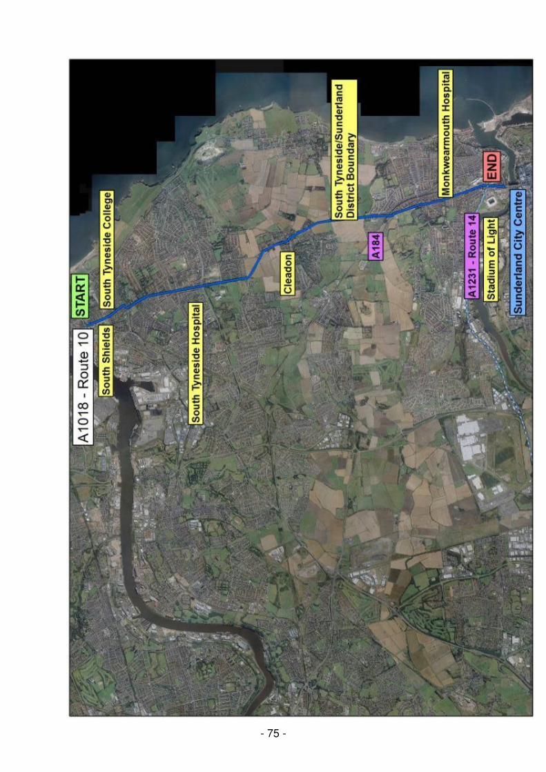
- 74 - Sunderland (For further information, see Map 9) A1018 Newcastle Road (Corridor 10) The A1018 corridor runs northbound between the city centre and the city boundary to the north of Seaburn. Immediately to the north of the city centre, the corridor crosses the River Wear via the Wearmouth Bridge, which is four lanes wide. There is significant peak hour congestion at both ends of the bridge. The corridor is an important bus route, in addition to being served by three Metro stations at St Peter’s, Stadium of Light and Seaburn. Beyond the city boundary, the road continues into South Tyneside as Shields Road and then King George Road. Interventions on this section are detailed in the A1018 South Tyneside section of this report. Future plans Bus (or no-car) lanes are being considered for the Wheatsheaf Gyratory (between Southwick Road and Crozier Street) along with cycle lanes to link to the cycle lanes on the A1018 in North Tyneside. These measures are the subject of ongoing study. Studies are also taking place into possible improvements to the Wheatsheaf Gyratory. Public consultation is currently taking place on proposals to improve the junction and add another lane on the Southwick Road approach; work (if approved) would begin in 2008/09, as part of the Bus Corridor Improvement Major Scheme (Phase 1) bid. Improvements to Wheatsheaf Gyratory to replace junction with one signalised crossing are also included in phase 1 of the Bus Corridor major Scheme bid. The study has also looked at the operation of the North Bridge Street / Roker Avenue / Dame Dorothy Street gyratory system. The case for introducing two-way traffic operation on North Bridge Street, coupled with a bus priority link from Southwick Road, has been considered but it was found that no real benefit would accrue from this measure. There is also currently a study underway to determine highway infrastructure improvements on the B1298 to improve bus operation with any proposals potentially being included in Phase 2 of the Bus Corridor Major Scheme bid. Travel Plan issues On the east side of the A1018 corridor are located St Peter’s University Campus and Monkwearmouth Hospital. The University have recently set up a Transport Strategy Group, attended by the City Council, which is concerned with a variety of transport related issues. In addition, the City Council has met with Sunderland City Hospitals, who aim to develop travel plan measures for their hospitals. Two schools on this corridor are developing a School Travel Plan and a further four schools are to be encouraged to adopt a School Travel Plan in future.
Transcript
- 74 -
Sunderland (For further information, see Map 9) A1018 Newcastle Road (Corridor 10) The A1018 corridor runs northbound between the city centre and the city boundary to the north of Seaburn. Immediately to the north of the city centre, the corridor crosses the River Wear via the Wearmouth Bridge, which is four lanes wide. There is significant peak hour congestion at both ends of the bridge. The corridor is an important bus route, in addition to being served by three Metro stations at St Peter’s, Stadium of Light and Seaburn. Beyond the city boundary, the road continues into South Tyneside as Shields Road and then King George Road. Interventions on this section are detailed in the A1018 South Tyneside section of this report. Future plans Bus (or no-car) lanes are being considered for the Wheatsheaf Gyratory (between Southwick Road and Crozier Street) along with cycle lanes to link to the cycle lanes on the A1018 in North Tyneside. These measures are the subject of ongoing study. Studies are also taking place into possible improvements to the Wheatsheaf Gyratory. Public consultation is currently taking place on proposals to improve the junction and add another lane on the Southwick Road approach; work (if approved) would begin in 2008/09, as part of the Bus Corridor Improvement Major Scheme (Phase 1) bid. Improvements to Wheatsheaf Gyratory to replace junction with one signalised crossing are also included in phase 1 of the Bus Corridor major Scheme bid. The study has also looked at the operation of the North Bridge Street / Roker Avenue / Dame Dorothy Street gyratory system. The case for introducing two-way traffic operation on North Bridge Street, coupled with a bus priority link from Southwick Road, has been considered but it was found that no real benefit would accrue from this measure. There is also currently a study underway to determine highway infrastructure improvements on the B1298 to improve bus operation with any proposals potentially being included in Phase 2 of the Bus Corridor Major Scheme bid. Travel Plan issues On the east side of the A1018 corridor are located St Peter’s University Campus and Monkwearmouth Hospital. The University have recently set up a Transport Strategy Group, attended by the City Council, which is concerned with a variety of transport related issues. In addition, the City Council has met with Sunderland City Hospitals, who aim to develop travel plan measures for their hospitals.
Two schools on this corridor are developing a School Travel Plan and a further four schools are to be encouraged to adopt a School Travel Plan in future.
- 75 -
- 76 -
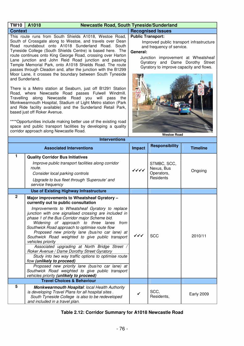
Table 2.12: Corridor Summary for A1018 Newcastle Road
TW10 A1018 Newcastle Road, South Tyneside/Sunderland
Context Recognised Issues Public Transport:
� Improved public transport infrastructure and frequency of service.
General:
� Junction improvement at Wheatsheaf Gyratory and Dame Dorothy Street Gyratory to improve capacity and flows.
This route runs from South Shields A1018, Westoe Road, South of Crossgate along to Westoe, and travels over Dean Road roundabout onto A1018 Sunderland Road. South Tyneside College (South Shields Centre) is based here. The route continues onto King George Road, crossing over Harton Lane junction and John Reid Road junction and passing Temple Memorial Park, onto A1018 Shields Road. The route passes through Cleadon and, after the junction with the B1299 Moor Lane, it crosses the boundary between South Tyneside and Sunderland. There is a Metro station at Seaburn, just off B1291 Station Road, where Newcastle Road passes Fulwell Windmill. Travelling along Newcastle Road you will pass the Monkwearmouth Hospital, Stadium of Light Metro station (Park and Ride facility available) and the Sunderland Retail Park, based just off Roker Avenue. ****Opportunities include making better use of the existing road space and public transport facilities by developing a quality corridor approach along Newcastle Road.
Westoe Road
Interventions
Associated Interventions Impact Responsibility
Timeline
Quality Corridor Bus Initiatives
� Improve public transport facilities along corridor route.
� Consider local parking controls
1
� Upgrade to bus fleet through ‘Superoute’ and service frequency
����������������
STMBC, SCC, Nexus, Bus Operators, Residents
Ongoing
Use of Existing Highway Infrastructure
Major improvements to Wheatsheaf Gyratory – currently out to public consultation
� Improvements to Wheatsheaf Gyratory to replace junction with one signalised crossing are included in phase 1 of the Bus Corridor major Scheme bid. � Widening of approach to three lanes from Southwick Road approach to optimise route flow � Proposed new priority lane (bus/no car lane) at Southwick Road weighted to give public transport vehicles priority � Associated upgrading at North Bridge Street / Roker Avenue / Dame Dorothy Street Gyratory
� Study into two way traffic options to optimise route flow (unlikely to proceed)
2
� Proposed new priority lane (bus/no car lane) at Southwick Road weighted to give public transport vehicles priority (unlikely to proceed)
������������ SCC 2010/11
Travel Choices & Behaviour
5 � Monkwearmouth Hospital: local Health Authority is developing Travel Plans for all hospital sites . �South Tyneside College is also to be redeveloped and included in a travel plan.
���� SCC, Residents,
Early 2009
- 77 -
A1018 Ryhope Road (Corridor 12) The A1018 extends southwards from the city centre to the A19 trunk road south of Ryhope. The route has traditionally carried high volumes of through traffic causing significant environmental problems, particularly where housing and shops front directly onto the highway. Southern Radial Route The aforementioned problems have been addressed by the completion of the Southern Radial Route in 2007. The route has been planned to help increase economic prosperity within Sunderland. It improves access to the industrial and commercial areas of east Sunderland, thereby opening up opportunities to boost inward investment, improve the economy and create jobs. It also creates better links to the City Centre. The Southern Radial Route creates a bypass of Ryhope village and Grangetown shopping centre for through traffic facilitating the implementation of measures on the existing corridor such as traffic calming. As the new link becomes fully established, it is expected to have a major impact on reducing congestion on the A1018 south of Sunderland centre.
The route comprises two sections: South Section The southern section is around 3.3km long and comprises a new 10-metre wide single carriageway running between the A1018 south of Ryhope and Ocean Road in Grangetown. This section included the construction of three roundabouts, retaining walls, underpass and culvert improvements and new landscaping.
- 78 -
North Section The northern section is around 1.4km long and comprises improvements to the existing highway along Commercial Road between Ocean Road and the Raich Carter Sports Centre. This section included the construction or remodelling of four roundabouts, a junction with traffic signals and the implementation of extensive traffic management schemes. Future plans For 2008/09, a bus priority scheme is proposed for Ryhope Road, to run between Mowbray Road and Queen Alexandra Road. The possibility of converting this into a no-car lane, which may receive more widespread support, is also being studied. This scheme is costed at £100,000. In addition, traffic calming measures along the route will be delivered in 2008/09 as part of the corridor treatment and there will be junction improvements to the Toll Bar Road roundabout. Travel Plan measures Ryhope General Hospital is located adjacent to the corridor. The City Council has met with Sunderland City Hospitals, who aim to develop travel plan measures for their hospitals. There are no other large employment sites adjacent to this corridor.
Southmoor secondary school fronts onto the corridor. Three schools on this corridor have a School Travel Plan, and a further three are to be encouraged to adopt a School Travel Plan in future.
- 79 -
- 80 -
Table 2.13: Corridor Summary for B1252 Ryhope Road
(Note: The former A1018 is now designated as the Southern Radial Route)
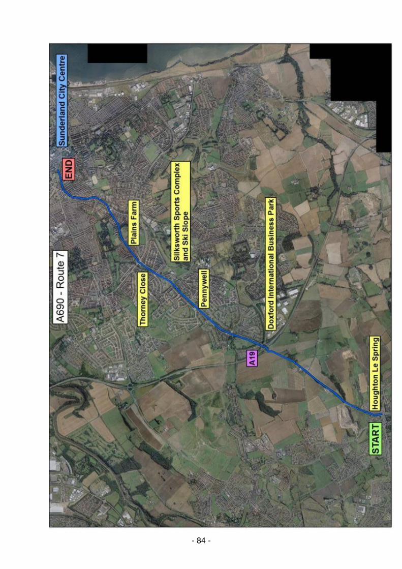
A690 Durham Road (Corridor 7) The A690 extends from the City Centre to the A19 Trunk Road and then to the A1 (M) motorway (bypassing Houghton-le-Spring and East Rainton), and continues to Durham City. As such it forms an important link between the city centre, two major national roads, and neighbouring Durham City. The Durham Road “Superoute” was implemented in two phases starting in 1998 and comprises 1630m of bus priority lane on several sections of the corridor between the city centre and the A19, in conjunction with provision of new bus shelters, improved passenger information and the introduction of a fleet of 21 new low floor “easy access” buses. Although the scheme has proved successful in terms of accelerating bus services and improving reliability, the scale of bus priority measures attracted some opposition and to ameliorate this, the bus lanes were converted into no-car lanes in June 2005, the first of their kind in Sunderland. “Before and after” monitoring was carried out to determine the effects of the change. The council is now exploring the provision of Real-Time Bus Passenger Information (RTI) along the corridor.
TW12 B1252 Ryhope Road, Sunderland Context
This route runs from the Easington boundary, starting at the B1287 Sea View, leading to the junction with Ryhope Road. Ryhope Road was formerly designated as the A1018 but this title has now been assigned to the Southern Radial Route, which forms a bypass of Ryhope Village and the busy Grangetown shopping area. Ryhope Road (now the B1252) passes through Grangetown and Hendon, ending at the junction of Whitehouse Road and Hendon Road, close to the city centre.
Junction improvement planned for Tollbar Junction – to introduce signals and bus priority
���������������� SCC
SRR completed 2007/08; Tollbar
Junction work in 2008/09
Quality Bus Initiatives 2
Bus priority to be introduced on dual carriageway ������������
SCC, Bus Operators
2009/10
Travel Plans
3 Ryhope General Hospital: local Health Authority is developing Travel Plans for all hospital sites
���� SCC, Hospital, Staff, NHS
Early 2009
- 81 -
Recent interventions The junction of the A690 with the A19 is signalised and carries high traffic flows, frequently causing congestion at peak times (including on the A19 slip roads and on occasion onto the A19 carriageway). The Highways Agency developed a £1.5m project to improve the southbound off-slip road and this was delivered in 2007/08 with the aid of £250,000 LTP funding. The heavy volumes of traffic at this junction are associated with the adjacent Doxford International Business Park located on City Way, where 37 organisations are located which employ approximately 8000 staff. The rapid growth of the Business Park, which lies slightly to the east of the A690 corridor, has led to difficulties with parking and congestion and various measures are underway to alleviate this, including investigation of possible Park and Ride sites, more bus priority and continued development of the Doxford Travel Plan.
Future plans Improvements are planned for the North Moor Lane junction (2008/09), the Grindon Lane junction (2009/10) and the junction following Prospect (2009/10). All these measures are planned to improve traffic flow through the junctions and enhance pedestrian crossing facilities. Further bus priority measures and a possible Park and Ride site are to be appraised; if implemented, this would be as part of the Bus Corridor Improvement Major Scheme (Phase 3) bid. Apart from the Business Park and Rainton Bridge there are no major employers located along the corridor.
- 82 -
Spatial issues The Northern Rock development at Rainton Bridge South was originally expected to host 4000 jobs but this is now doubtful in view of the bank’s current downsizing. This reinforces the view held by traffic managers that the A690 in this location near Houghton-le Spring has sufficient reserve capacity to accommodate the additional traffic. Travel Plan issues
Rainton Bridge
Rainton Bridge North (an existing industrial estate), and Rainton Bridge South (a major extension) are both located on the B1284 close to its junction with the A690. Travel Plan measures associated with the development of Rainton Bridge South are under discussion as part of the development proposals.
Doxford International Business Park
The Business Park is located adjacent to the junction of the A19 and A690. Over 8,000 staff are employed by 21 organisations at the Business Park including several head offices and a number of contact centres.
Significant volumes of traffic at the junction are associated with the Business Park and the site itself suffers from increasing peak-time congestion and parking difficulties.
The City Council, working with businesses, public transport operators, Nexus and the site management company, set out in summer 2005 to develop a Travel Plan Strategy for Doxford Business Park, aimed at addressing these problems.
The project, carried out by consultants acting on behalf of the City Council, included engaging with senior business representatives; staff travel surveys; traffic and infrastructure surveys; and holding a Travel Plan Forum and series of workshops (attended by business representatives), to discuss issues such as public transport provision. In addition, a series of newsletters were widely distributed to keep stakeholders and employees informed of progress and raise awareness of travel issues. The aim of the project was to examine existing travel patterns and develop a series of travel plans comprising an overarching site travel plan, individual travel plans for businesses, and several “mode specific” travel plans. Key objectives were to improve social inclusion, widen travel choice and reduce the proportion of single occupancy car journeys. Improving accessibility by all modes, particularly for employees without access to a car, will widen employment opportunities.
- 83 -
It was considered particularly important that businesses should agree to collectively take responsibility for helping to find and implement long-term transport solutions for the Business Park, by means of developing a partnership.
The Doxford Business Park Transport Working Group was established to enable the businesses to take over ownership of the travel plan, with ongoing support and advice from the City Council and Nexus. A key action was the launch and promotion of an intranet-based car share scheme, because survey results indicated that around 70% of all staff (including non-car users) were willing to car share.
Bus-only link at Doxford Park
Educational sites The University of Sunderland campus lies adjacent to the corridor. The University has a Transport Strategy Group, attended by the City Council, which is concerned with a variety of transport related issues. Large schools on, or adjacent to the corridor, are Bede Sixth Form College (on Durham Road), Sandhill View (on Grindon Lane mid way between the A690 and A183 Chester Road corridors) and Houghton Kepier (on Dairy Lane in Houghton le Spring). Three schools on this corridor have a School Travel Plan, four are developing a School Travel Plan and a further eleven schools are to be encouraged to adopt a School Travel Plan in future. A Workplace Travel Plan will be developed for the Bede site (as further education falls outside the remit of School Travel Plans).
- 84 -
- 85 -
Table 2.14: Corridor Summary for A690 Durham Road
TW07 A690 Durham Road, Sunderland Context
This route runs from Houghton-le-Spring, travelling along the A690, then crossing the A19 Sunderland Bypass at the Stoneygate / East Herrington / Doxford International roundabout. This is a very busy link, due to traffic from the A19 and local traffic for Doxford International Business Park (pictured below). The A690 travels through largely residential areas of East / Middle Herrington, Thornley Close, and Plains Farm. There are a number of schools along this section, both primary and secondary, as well as Silksworth Sports Complex. Durham Road crosses Queen Alexandra Road and into the centre of Sunderland, where it meets A1231 Stockton Road.
Doxford Business Park A690 No-Car Lane
****Opportunities include making better use of the existing road space, improving public transport and encouraging modal shift through travel plans and parking controls. Proposals for Park and Ride facilities at the junction with the A19 are also under consideration.
� Improved public transport infrastructure facilities along corridor route. Measures include raised kerbs at bus stops, a bus stop audit and a review of the present No-Car Lane
1
� Upgrades to bus fleet through Superoute and service frequency
���������������� SCC, Bus Operators, Nexus
2008/09
Use of Existing Highway Infrastructure
2 Traffic management improvements to 2 junctions
� Grindon Lane and junction following Prospect - minor junction layout works to improve traffic flow and enhance pedestrian crossing facilities.
���� SCC 2009/10
� North Moor Lane junction - minor junction layout works to improve traffic flow and enhance pedestrian crossing facilities
���� SCC 2008/09
Travel Choices & Behaviour
3 � Rainton Bridge Workplace Travel Plan to encourage modal shift
���� SCC, Local Businesses
In place
� Doxford International Workplace Travel Plan to encourage modal shift
���� SCC, Local Businesses
In place
� University of Sunderland Travel Plan to encourage modal shift
���� SCC, University In place
� School Travel Plans to encourage modal shift – various schools along corridor – Bede 6
th Form College
/ Sandhill View / Houghton Kepier.
���� SCC, College, School, LEA
Ongoing
- 86 -
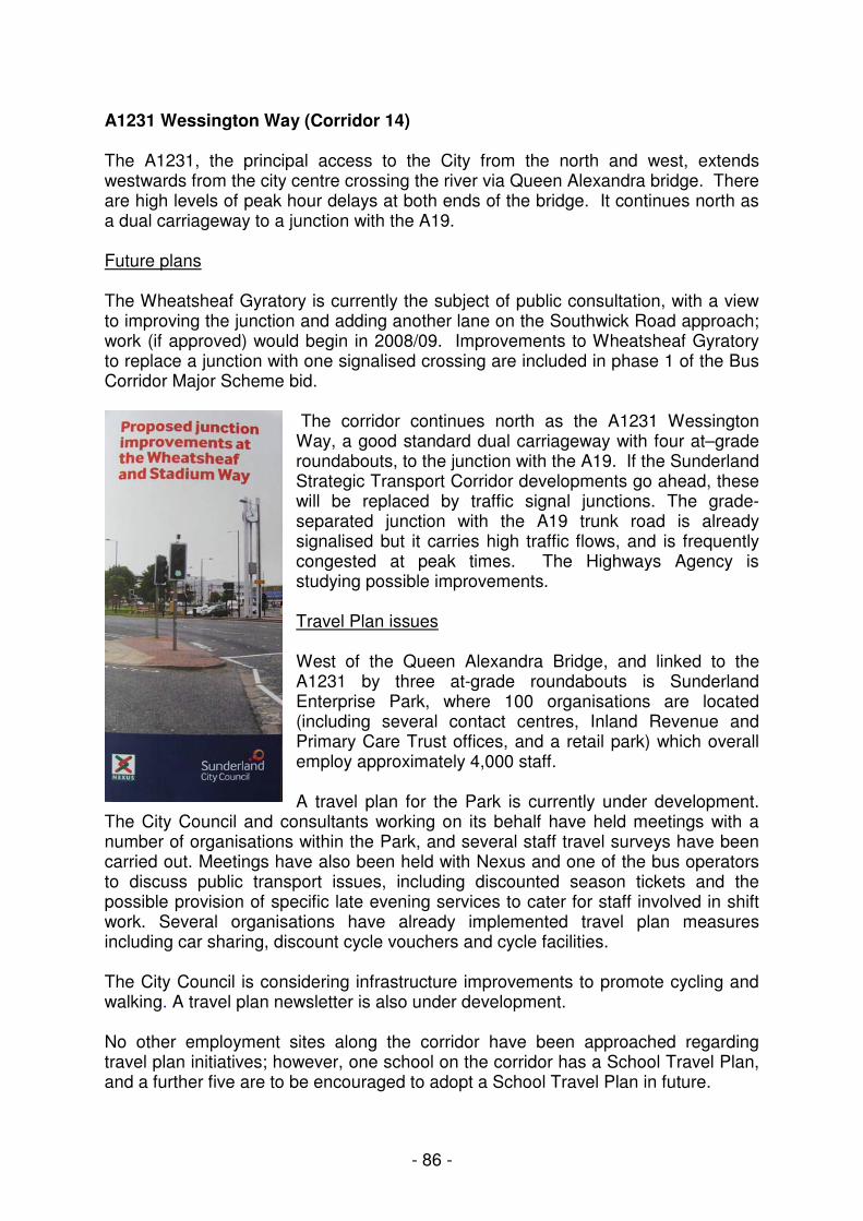
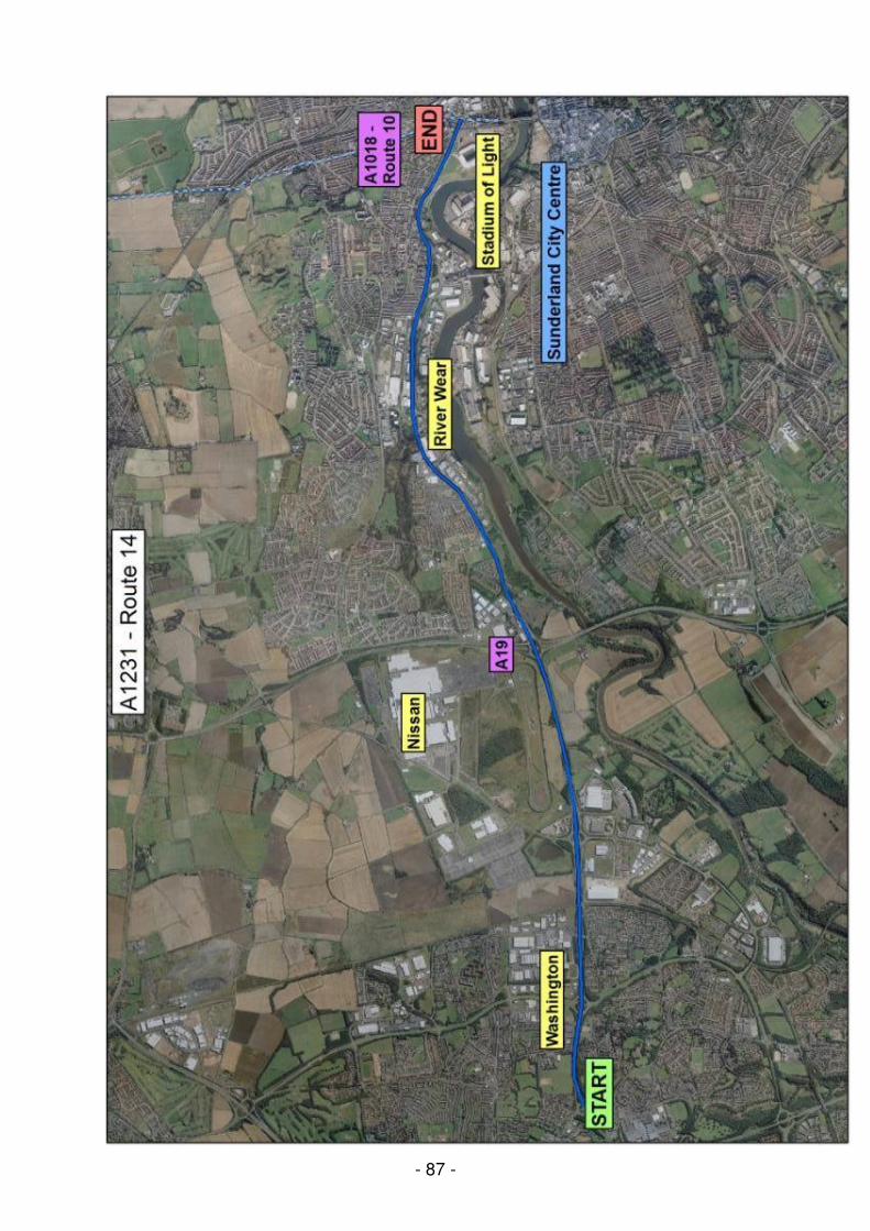
A1231 Wessington Way (Corridor 14) The A1231, the principal access to the City from the north and west, extends westwards from the city centre crossing the river via Queen Alexandra bridge. There are high levels of peak hour delays at both ends of the bridge. It continues north as a dual carriageway to a junction with the A19. Future plans The Wheatsheaf Gyratory is currently the subject of public consultation, with a view to improving the junction and adding another lane on the Southwick Road approach; work (if approved) would begin in 2008/09. Improvements to Wheatsheaf Gyratory to replace a junction with one signalised crossing are included in phase 1 of the Bus Corridor Major Scheme bid.
The corridor continues north as the A1231 Wessington Way, a good standard dual carriageway with four at–grade roundabouts, to the junction with the A19. If the Sunderland Strategic Transport Corridor developments go ahead, these will be replaced by traffic signal junctions. The grade-separated junction with the A19 trunk road is already signalised but it carries high traffic flows, and is frequently congested at peak times. The Highways Agency is studying possible improvements.
Travel Plan issues West of the Queen Alexandra Bridge, and linked to the A1231 by three at-grade roundabouts is Sunderland Enterprise Park, where 100 organisations are located (including several contact centres, Inland Revenue and Primary Care Trust offices, and a retail park) which overall employ approximately 4,000 staff. A travel plan for the Park is currently under development.
The City Council and consultants working on its behalf have held meetings with a number of organisations within the Park, and several staff travel surveys have been carried out. Meetings have also been held with Nexus and one of the bus operators to discuss public transport issues, including discounted season tickets and the possible provision of specific late evening services to cater for staff involved in shift work. Several organisations have already implemented travel plan measures including car sharing, discount cycle vouchers and cycle facilities. The City Council is considering infrastructure improvements to promote cycling and walking. A travel plan newsletter is also under development.
No other employment sites along the corridor have been approached regarding travel plan initiatives; however, one school on the corridor has a School Travel Plan, and a further five are to be encouraged to adopt a School Travel Plan in future.