14
Page | 1 Surfaces Data Gulfaks, North Sea John Doe July 2011 Schlumberger
| Date post: | 27-Dec-2015 |
| Category: |
Documents |
| Upload: | mohamed-awad |
| View: | 16 times |
| Download: | 0 times |

Page | 1
Surfaces Data
Gulfaks, North Sea
John Doe
July 2011
Schlumberger
Page | 2
Table of Contents
1 EXECUTIVE SUMMARY .......................................................................................................................... 3
2 Summary of Results .............................................................................................................................. 4
2.1 Contour Map ................................................................................................................................. 4
2.1.1 Base Cretaceous .................................................................................................................... 8
2.1.2 Top Tarbert ........................................................................................................................... 9
2.1.3 Top Ness .............................................................................................................................. 10
2.1.4 Top Etive.............................................................................................................................. 11
2.2 Elevation Depth ........................................................................................................................... 12
2.2.1 Base Cretaceous .................................................................................................................. 12
2.2.2 Top Tarbert ......................................................................................................................... 12
2.2.3 Top Ness .............................................................................................................................. 12
2.2.4 Top Etive.............................................................................................................................. 12
2.3 General intersection ................................................................................................................... 13
2.3.1 North-south intersection .................................................................................................... 13
2.3.2 East-west intersection......................................................................................................... 14

Page | 3
1 EXECUTIVE SUMMARY
Base Cretaceous, Top Tarbert, Top ness and Top Etive are the surfaces in Gulfaks reservoir,
located in the North Sea. The objective of the surfaces is to accomplish the building of static
model.

Page | 4
2 Summary of Results
2.1 Top Surface Bitmap
2.1.1 Base Cretaceous

Page | 5
2.1.2 Top Tarbert
Page | 6
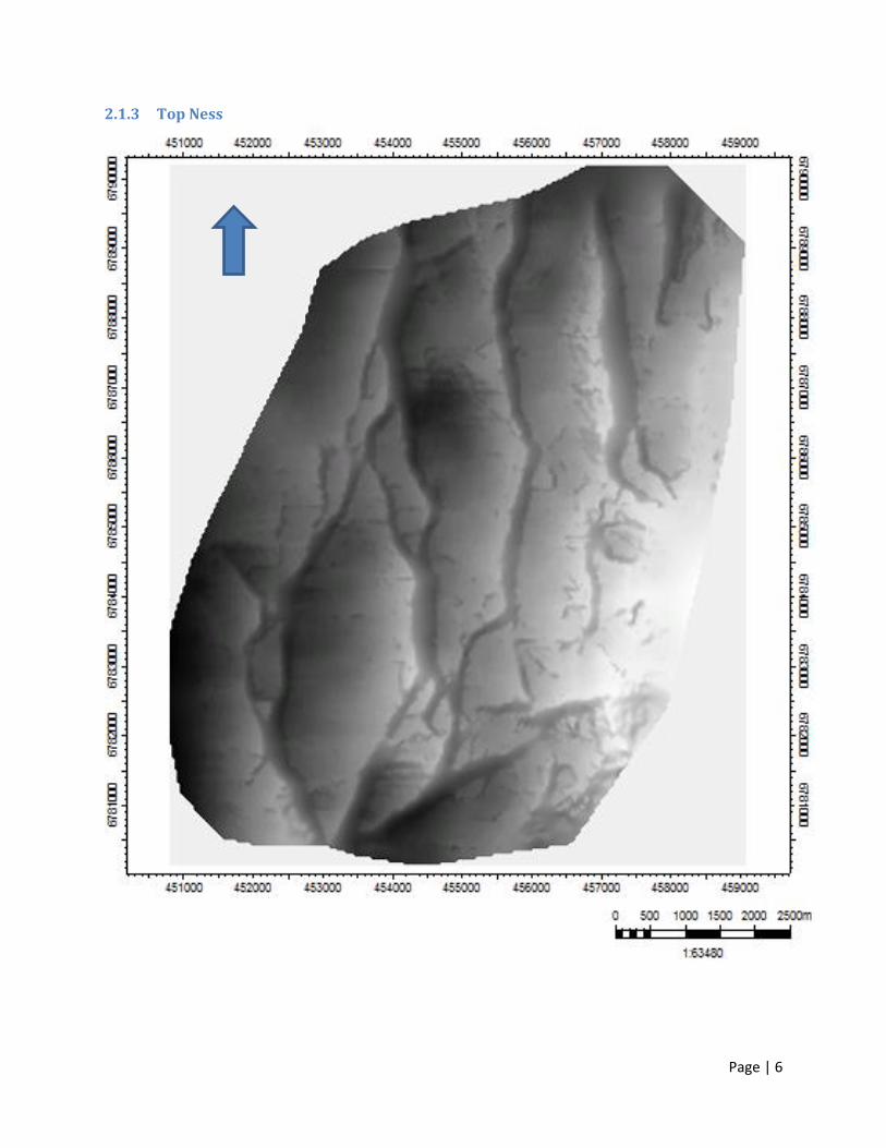
2.1.3 Top Ness

Page | 7
2.1.4 Top Etive

Page | 8
2.2 Contour Map
2.2.1 Base Cretaceous

Page | 9
2.2.2 Top Tarbert

Page | 10
2.2.3 Top Ness

Page | 11
2.2.4 Top Etive

Page | 12
2.3 Elevation Depth
2.3.1 Base Cretaceous
Axis Elevation depth [m]
Min -1988.15
Max -1654.72
Delta 333.42
2.3.2 Top Tarbert
Axis Elevation depth [m]
Min -2107.42
Max -1644.67
Delta 462.75
2.3.3 Top Ness
Axis Elevation depth [m]
Min -2131.51
Max -1644.46
Delta 487.05
2.3.4 Top Etive
Axis Elevation depth [m]
Min -2188.06
Max -1625.85
Delta 562.21

Page | 13
2.4 General intersection
2.4.1 North-south intersection

Page | 14
2.4.2 East-west intersection


