34
SURFACE WATER ISSUES IN THE GMA 7 JPINT PLANNING PROCESS Caroline Runge, Consulting Manager Menard County Underground Water District June 18, 2015
| Date post: | 31-Jul-2015 |
| Category: |
Education |
| Upload: | the-texas-network-llc |
| View: | 171 times |
| Download: | 1 times |

SURFACE WATER ISSUES IN THE GMA 7 JPINT PLANNING
PROCESS
Caroline Runge, Consulting Manager
Menard County Underground Water District
June 18, 2015

Groundwater Management Areas

Major Aquifers in GMA 7
•Edwards-Trinity (Plateau)
•Ogallala
•Pecos Valley Alluvium
•Trinity

Edwards-Trinity (Plateau) Aquifer

Minor Aquifers in GMA 7
Capitan ReefDockumEllenburger-San SabaHickoryLipanMarble FallsRustler

Minor Aquifers of GMA 7
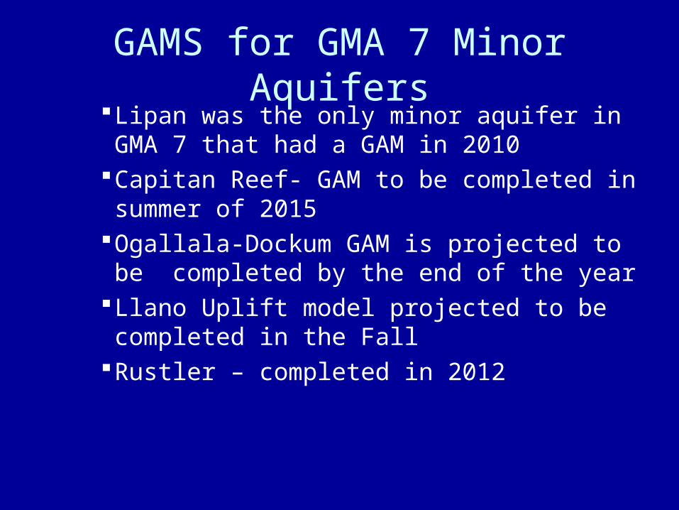
GAMS for GMA 7 Minor AquifersLipan was the only minor aquifer in GMA 7
that had a GAM in 2010Capitan Reef- GAM to be completed in
summer of 2015Ogallala-Dockum GAM is projected to be
completed by the end of the yearLlano Uplift model projected to be completed
in the FallRustler – completed in 2012

Achieving balance among various competing interests in groundwater is a primary
management task of groundwater conservation
districts

Balancing
•Maximizing production of water for economic use v. conserving water for the future and protection of the resource

BALANCING
Allocation of water for competing uses within the district:
Agricultural Municipal public water supply Oil and Gas and mining exempt uses Industrial Environmental Recreational
Balancing
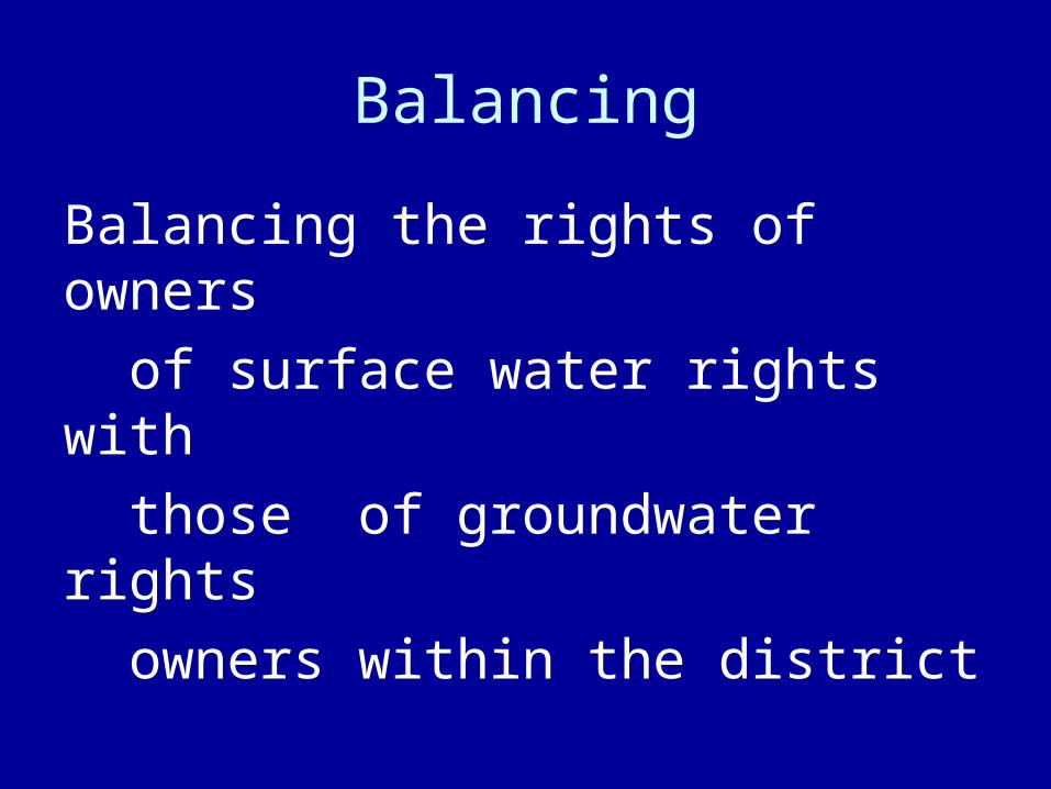
Balancing the rights of owners
of surface water rights with
those of groundwater rights
owners within the district

It is worthy of note that all of Texas’ largest springs burst
from Edwards and associated limestones –
Gunnar BruneSprings of Texas, 1981

Surface Water is the Primary Water Supply in
Several GMA 7 Districts
• 90% of all water use in Menard County is surface water, including all municipal and most agricultural irrigation;
• 80% of all water use in Kimble County is surface water, including all municipal and most agricultural irrigation

§ 36.113 TEXAS WATER CODE
§ 36.113. PERMITS FOR WELLS. (d) Before granting or denying a permit, the district shall consider
whether: (1) the application conforms to the requirements
prescribed by this chapter and is accompanied by the prescribed fees;
(2) the proposed use of water unreasonably affects existing groundwater and surface water resources or existing permit holders;
(3) the proposed use of water is dedicated to any beneficial use; (4) the proposed use of water is consistent with the district's certified water management plan; (5) the applicant has agreed to avoid waste and achieve water conservation;

Balancing Usage Among The Districts In The Management Area
Historic surface water use in a district vs. existing or projected growth in groundwater use in an adjoining district is one of the factors that has to be considered by GMA 7 in adopting DFCs

Catchment Basin forMajor Springs on San Saba River

Region F Well Yield Map

DESIRED FUTURE CONDITIONS(DFCs)
The condition which groundwater conservation districts within a GMA desire the respective relevant aquifers to be in fifty years from the start of the planning cycle
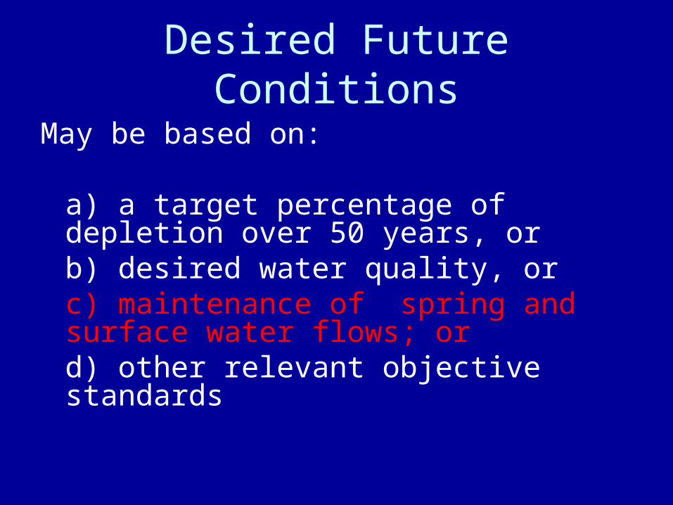
Desired Future Conditions
May be based on:
a) a target percentage of depletion over 50 years, orb) desired water quality, orc) maintenance of spring and surface water flows; or d) other relevant objective standards

36.108 (d)
• (4) other environmental impacts, including impacts on spring flow and other interactions between groundwater and surface water;

HEADWATERS of RIVERS LOCATED in GROUNDWATER MANAGEMENT AREA 7
RIO GRANDE RIVER BASINWest Nueces and NuecesFrio DevilsDry Devils
COLORADO RIVER BASIN North Llano, South Llano, and Llano
South Concho San Saba

RIVERS IN GMA 7

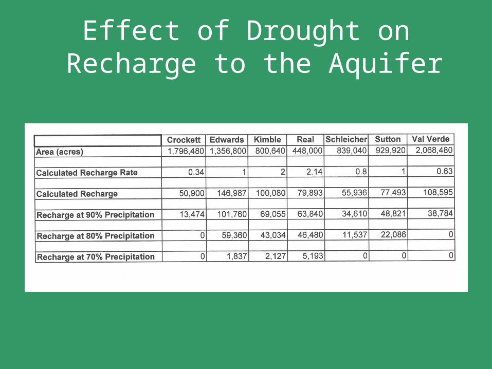
Effect of Drought on Recharge to the Aquifer

Contributions to Flows in the Rio Grande
• 4 counties out of the 30 in GMA 7 produce 48% of the total MAG.
• These counties make significant contributions to flows in the Rio Grande.

Flows in Rio Grande Tributaries 2010 and 2012
Location Discharge 3/12/10(cfs)
DischargeAcre-feet/year
Discharge 2/17/12
(cfs)
Discharge Acre-Feet/year
Rio Grande below Conchos at Presidio
168 122,033 24.7 17,908
Pinto Creek 21 15,203
Devils River near Pafford Crossing
364 263,525 183 132,523
Pecos River near Langtry
268 197,204 130 94,403
San Felipe Creek 89.98 65,143
San Felipe Springs 116.4 84,270
Table 3.

Source: extracted from data on International Boundary and Water Commission website http:www.ibwc.state.gov/Water_Data histflo1.htm, March 13, 2010 and http:www.ibwc.state.gov/Water_DataReports/RGFlow_data.html, February 17, 2012/
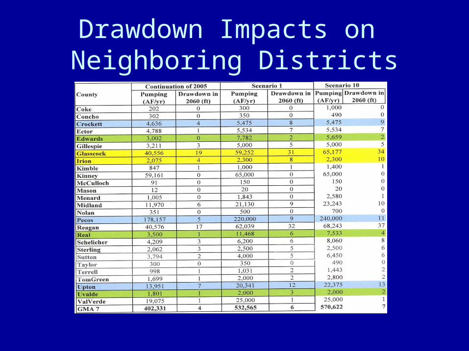
Drawdown Impacts on Neighboring Districts

1944 Mexican Water Treaty
• Article 4.B. (a) of the 1944 Mexican Water Treaty between the United States of America and Mexico (59 Stat. 1219), respecting the utilization of the waters of the Colorado, Tijuana and Rio Grande Rivers, specifically allocates to the United States all of the waters reaching the main channel of the Rio Grande (Rio Bravo)
from the Pecos and Devils Rivers, Goodenough Spring, and
Alamito, Terlingua, San Felipe and Pinto Creeks. With the exception
of Alamito and Terlingua Creeks, the above-named rivers, springs
and creeks all reach the Rio Grande from GMA 7.
Treaty Waters Critical to Downstream Texas Municipalities and Farmers
Those tributaries specifically named in the treaty are the only waters flowing into the Rio Grande from either side of the border that are allocated 100% to the United States. All other inflows from Fort Quitman downstream are divided between the United States and Mexico.
As Mexico is, with increasing frequency, failing to make its
deliveries to the Rio Grande required by the treaty, inflows into the Rio Grande from the tributaries located in GMA 7 are increasingly critical to meet the existing permitted and adjudicated water uses by
downstream municipalities and other users.
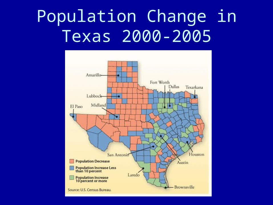
Population Change in Texas 2000-2005
MODELED AVAILABLE GROUNDWATER (MAG)
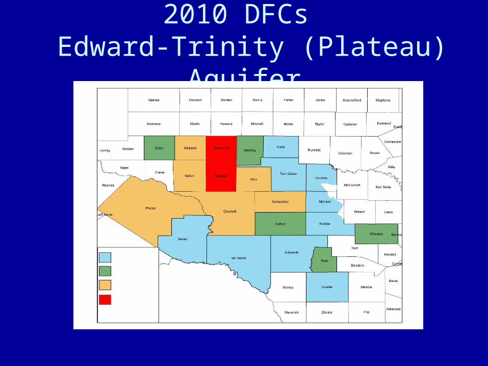
2010 DFCs Edward-Trinity (Plateau) Aquifer


