Survey of Architectural Resources Norwood and Wingina Vicinities Nelson County, Virginia Prepared By: Prepared For: The County of Nelson and the Virginia Department of Historic Resources JUNE 2014
Transcript
Survey of Architectural Resources Norwood and Wingina Vicinities
Nelson County, Virginia
Prepared By:
Prepared For:The County of Nelson
and the Virginia Department of Historic Resources
JUNE 2014
Survey of Architectural Resources in the Norwood and Wingina Vicinities of Nelson County, Virginia
2 | P a g e
Survey of Architectural Resources Norwood and Wingina Vicinities of Nelson County, Virginia Principal Investigator: W. Scott Breckinridge Smith, Principal HistoryTech, LLC Post Office Box 75 Lynchburg, Virginia 24505 (434) 401-3995 www.historytech.com Report Prepared For: County of Nelson 84 Courthouse Square Lovingston, Virginia 22949 (434) 263-7000 Virginia Department of Historic Resources 2801 Kensington Avenue Richmond, Virginia 23221 (804) 367-2323 June 2014
Cover Photo: CSX Railroad, James River & Kanawha Canal, and the Wingina Post Office
Survey of Architectural Resources in the Norwood and Wingina Vicinities of Nelson County, Virginia
3 | P a g e
Table of Contents Table of Figures ............................................................................................................................................................................................ 4
Time Periods in Virginia Prehistory and History ......................................................................................................................... 13
Prehistoric Native American Settlement and European Settlement to Society (1607-1750) ..................................... 14
Colony to Nation (1750-1789) .......................................................................................................................................................... 15
Early National Period (1789-1830) .................................................................................................................................................. 17
Antebellum Period (1830-1860) ...................................................................................................................................................... 19
Civil War (1861-1865) .......................................................................................................................................................................... 22
Reconstruction and Growth (1865-1917) ..................................................................................................................................... 24
World War I to World War II (1917-1945) ...................................................................................................................................... 29
The New Dominion (1945-1989) and Post-Cold War Era (1990-Present) .......................................................................... 31
CHAPTER 4. Summary of Survey Findings and Results ................................................................................................................. 34
Threats to Resources ........................................................................................................................................................................... 35
CHAPTER 5. Evaluation and Recommendations ............................................................................................................................. 38
Evaluation of Historic Resources ..................................................................................................................................................... 38
Public Policy Initiatives .................................................................................................................................................................. 46
APPENDIX I. Norwood-Wingina Project Area Overview ............................................................................................................... 55
APPENDIX II. William Cabell’s 1738 Patent ........................................................................................................................................ 56
APPENDIX III: 1820 Hugh Taylor Map ................................................................................................................................................. 57
APPENDIX IV: 1824 Claudius Crozet Map .......................................................................................................................................... 58
APPENDIX V: Civil War Era Roads .......................................................................................................................................................... 59
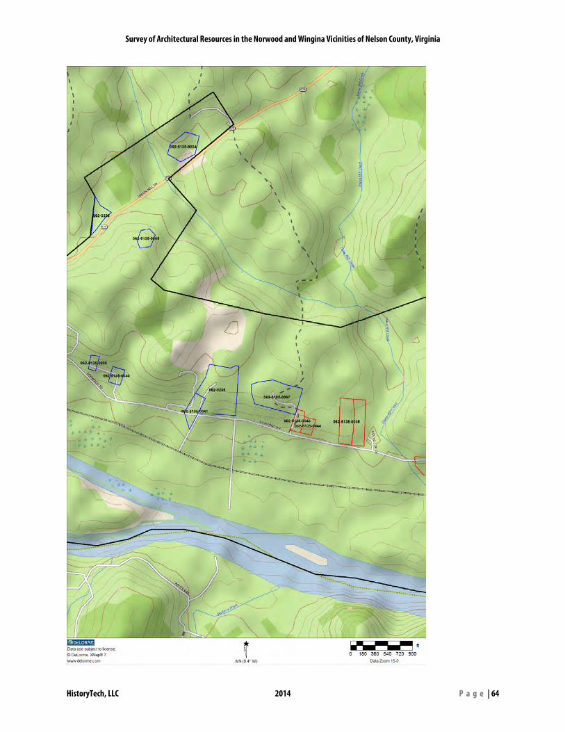
APPENDIX VI: Maps of Resources in Study Area .............................................................................................................................. 61
APPENDIX VII: Surveyed Historic Resources Sorted by DHR ID Number ................................................................................ 69
APPENDIX VIII. Bibliography .................................................................................................................................................................. 71
APPENDIX IX. Endnotes ........................................................................................................................................................................... 72
Survey of Architectural Resources in the Norwood and Wingina Vicinities of Nelson County, Virginia
4 | P a g e
Table of Figures Figure 1- The Norwood-Wingina project area is shown in bright pink in the southeastern corner of Nelson County ............................................................................................................................................................................................................. 6 Figure 2- A cedar-lined section of Norwood Road (State Route 626) ........................................................................................ 7 Figure 3- Draft project area boundaries developed prior to commencement of the project ......................................... 10 Figure 4- View of Variety Mills Road looking southward towards Norwood Road ............................................................. 11 Figure 5- Detail of the 1751 Jefferson-Fry Map of Virginia showing the area that would become Nelson County. 13 Figure 6- Detail of John Smith's early 17th century map of Virginia showing the Monacan village of Monahassanough (upper left corner) near present-day Wingina. Rassawek was located at the confluence of the James and Rivanna Rivers near present-day Columbia. ............................................................................................................... 14 Figure 7- Soldier's Joy (062-0015) is one of the earliest extant buildings in the Norwood-Wingina study area ....... 16 Figure 8- Circa 1930 photo of Union Hill by Frances Benjamin Johnston (image: Library of Congress) ...................... 16 Figure 9- An early image of a James River Batteau (Tatham, “Essay on Tobacco,” 1800) ................................................. 16 Figure 10- Detail of ca. 1820 "Survey of the James River from Warren to Lynchburg" by Hugh Taylor showing the village of New Market .............................................................................................................................................................................. 17 Figure 11- Lynchburg Weekly Gazette (October 13, 1798) advertisement announcing new merchandise at Robert Rives' stores along the James and Rivanna Rivers .......................................................................................................................... 17 Figure 12- Detail of an 1824 map of the “Canal in the valley of James River” by Claudius Crozet. The house labeled “McClelland’s” is Montezuma. ............................................................................................................................................... 18 Figure 13- Montezuma (062-0010) ...................................................................................................................................................... 19 Figure 14- Rock Cliff (062-0438) ............................................................................................................................................................ 20 Figure 15- Finely crafted stone bridge abutment (ca. 1849) (062-0035) on the south end of the Route 56 bridge over the James River in Buckingham County. ................................................................................................................................. 20 Figure 16- Christ Church (062-0003) ................................................................................................................................................... 21 Figure 17- Frederick G. Peters Store (062-0216) .............................................................................................................................. 21 Figure 18- An early image of Peters Store showing the later porches. Peters’ large frame house (no longer extant) can be seen to the right across Variety Mills Road. (WPA VA Historical Inventory) ............................................................. 22 Figure 19- Paul Stratton's Store (demolished) in New Market/Norwood. (WPA Virginia Historical Inventory, Library of Virginia). .................................................................................................................................................................................... 22 Figure 20- Detail of Civil War era map of Amherst and Nelson Counties. Roads are in deep red, and the James River & Kanawha Canal is in bold black. ............................................................................................................................................. 23 Figure 21- A post-Civil War view of Norwood (at top of hill to right of center) and its associated buildings ............ 24 Figure 22- Following the 1870 flood, Norwood merchant Charles Andrew Stratton constructed a new store (062-0238) along the canal about one mile downriver from Norwood. (Image: WPA VA Historical Inventory, Library of Virginia) ......................................................................................................................................................................................................... 25 Figure 23- An extensive article about the flood appeared in the Richmond Whig newspaper ....................................... 25 Figure 24- Bethany United Methodist Church (062-0237) prior to its 1950s expansion. (Image: Patricia Turner) ... 26 Figure 25- St. John Baptist Church (062-0236) ........................................................................................................................ 26 Figure 26- This School House (062-5135-0053) is said to be the first public school in Nelson County ........................ 27 Figure 27- A circa 1913 postcard featuring the Norwood School (062-0229) (Image: Corbis Images) ........................ 27 Figure 28- This faint early 20th century photo of Norwood (looking east from the west side of the Tye River) shows Norwood Road raised high above the flood plain as it approaches the former steel truss bridge across the Tye. Stratton’s Store (demolished) is to the right of center, and the F.G. Peters Store (062-0216) is to the left of the bridge. ........................................................................................................................................................................................................... 28 Figure 29- Wingina's Depot on the C&O Railroad (062-0034) (demolished) ......................................................................... 28 Figure 30- Wingina Store and Post Office (062-0233) ................................................................................................................... 29 Figure 31- The barn at Garnkirk (062-5135-0055) .......................................................................................................................... 29 Figure 32- The W.A. Turner House (062-5135-0033) ...................................................................................................................... 30 Figure 33- Col. Wirt Robinson's museum (062-5135-0050) adjacent to Arrowhead .......................................................... 30
Survey of Architectural Resources in the Norwood and Wingina Vicinities of Nelson County, Virginia
5 | P a g e
Figure 34- The Heath-Nunery House (062-5135-0012) in Norwood has a commanding view of the James and Tye Rivers below. ............................................................................................................................................................................................... 30 Figure 35- Advertisement for Camp Norwood in the Richmond Times-Dispatch, August 2, 1942. ............................... 31 Figure 36- Hurricane Camille destroyed the Tye River road bridge at Norwood. The damaged porches of Peters Store (062-0216) can be seen in the lower left corner .................................................................................................................. 32 Figure 37- The house at 8868 Norwood Road (062-5135-0048) is a good example of a late 20th century ranch style home ................................................................................................................................................................................................... 32 Figure 38- Dedication of the W.A.R. Goodwin marker in Norwood (Photo credit: Victoria Mininger, nelsoncountylife.com) ............................................................................................................................................................................. 33 Figure 39- A recreated James River Batteau prepares to land at Wingina ............................................................................. 33 Figure 40- The Nelson Store (062-0218) burned in the early 1990s. Only its foundation remains. ............................... 35 Figure 41- Old Norwood (062-0213) burns on December 9, 2012 (Image: Archer Guy Minardi) ................................... 36 Figure 42- This dwelling (062-0232) on the west side of the Tye River is one of several that have been demolished since the last survey was conducted in the 1990s ......................................................................................................................... 36 Figure 43- This post-1920 photograph shows the Wingina Store and Post Office (left), C&O Depot (right), and at least two other commercial buildings. Only the Wingina Store remains today. (Image: Barbara Wood) ................... 37 Figure 44- Christ Church (062-0003) was damaged by a September 2012 storm (photo courtesy: J.P. Harvey, nelsoncountylife.com) ............................................................................................................................................................................. 37 Figure 45- Distribution of Contributing (blue) and Non-contributing (red) primary and secondary resources within the study area ............................................................................................................................................................................... 40 Figure 46- District Boundary Option #2 showing a tighter district encompassing only the village of Norwood. Blue dots represent contributing resources. Red dots represent non-contributing resources. ..................................... 42 Figure 47- Arrowhead may be individually eligible for National Register listing because of its architectural character and association with Col. Wirt Robinson ....................................................................................................................... 44
CHAPTER 1. Introduction
The Norwood-Wingina Historic Resources Survey, conducted in 2012-13, was funded by the County of Nelson and the Cost Share Program of the Virginia Department of Historic Resources (DHR). The survey was modeled on DHR’s “Guidelines for Conducting Survey in Virginia for Cost Share Projects” (October 2011) and was undertaken by HistoryTech, a preservation planning firm based in Lynchburg.
The project was administered by Kristin Kirchen, DHR Architectural Historian, Carey Jones, DHR Architectural Survey Coordinator, Marc Wagner, Director of DHR’s Capital Region Office. The Steering Committee also included Maureen Kelley, Director of Economic Development and Tourism for Nelson County along with Becky Howard and Bob Carter of the Nelson County Historical Society. The survey team members included W. Scott Smith and Emily Patton Smith of HistoryTech. Scott Smith served as the project administrator and principal investigator.
The County of Nelson issued an RFQ (Request for Quotations) from consultants on July 30, 2012. Responses to the RFQ were received by August 15, and were evaluated by county staff. The selection of HistoryTech’s proposal was presented to the Nelson County Board of Supervisors at its September 11, 2012 meeting.
Project planning commenced in the fall of 2012 and included an initial Steering Committee meeting on October 17, 2012. An initial public meeting was held on November 15, 2012, and fieldwork was conducted from December 2012 through May 2013. A second public meeting was held on June 10, 2014.
Figure 1- The Norwood-Wingina project area is shown in bright pink in the southeastern corner of Nelson County
Survey of Architectural Resources in the Norwood and Wingina Vicinities of Nelson County, Virginia
HistoryTech, LLC 2014 P a g e | 7
Project Purpose and Goals The principal objectives of the survey were: To survey, at the reconnaissance
level, approximately 63 properties in the Norwood and Wingina vicinities
Create a PowerPoint presentation outlining survey findings
Create a survey report (this document) that includes historic context, evaluation of historic resources, building inventory list, and recommendations regarding the potential eligibility of the Norwood and Wingina areas for possible future listing as a state and national historic district.
Create reasonable and defendable boundaries for a possible future state and national historic district based on guidance provided by the National Park Service in National Register Bulletin 16A.
While the immediate goal of this project was to evaluate the eligibility of the Norwood and Wingina areas for listing in the state and national registers, the long-term goal is to help foster recognition and stewardship of the significant historic resources in the area.
Before venturing into the field, the survey team reviewed existing survey files at the Virginia Department of Historic Resources Archives in Richmond and conducted basic study of primary and secondary sources within the Nelson community. Maps from the eighteenth, nineteenth, and twentieth centuries, along with modern high-resolution aerial photography were used to identify sites that were likely to yield positive results. Finally, recommendations for possible properties to be surveyed were received from local citizens via telephone, letter, email, and public meetings. The survey team members used the above data to guide travel on county roads in search of candidate survey sites. Information was recorded on field forms and entered into DHR’s Data Sharing System (DSS) database software from which hardcopy files were generated. Properties were also digitally photographed, and locations were recorded by GPS (Global Positioning System) units.
Figure 2- A cedar-lined section of Norwood Road (State Route 626)
Survey of Architectural Resources in the Norwood and Wingina Vicinities of Nelson County, Virginia
HistoryTech, LLC 2014 P a g e | 8
Survey Products The following materials were produced by HistoryTech during this project: Architectural Survey Forms including physical descriptions of the primary and secondary resources on each property and evaluation of the property within its local historical and architectural context. These forms were entered into DHR’s cultural resources database. Photographs (black and white archival prints and color digital images) of the exterior elevations of each primary resource and of any secondary resources (outbuildings, cemeteries, etc.). Site Plans showing the location of the resources on the property. Topographic Maps showing the location of the property in relation to the greater area. Survey Report- The majority of the report is comprised of a historic context that is prefaced by a brief overview and description of the county and is organized by nine historic contexts (time periods) identified by DHR. The discussion proceeds roughly chronologically beginning with the 17th century. Selected properties from previous survey work in the area as well as properties newly-documented during the
2012-14 project are referred to in the report by name or site number. The prefix “062” identifies the resource as being within Nelson County. Subsequent numbers more specifically identify the individual resource. New archeological resources were not identified as a part of this project, but previously-identified resources that may be mentioned within this report utilize a different numbering system (44NE0055 is an example). Information on historic resources that are not accompanied by site numbers is derived from sources other than survey files (in other words, these sites have not been surveyed), or are resources that lie outside of the study area. The abbreviation “ca.” accompanies some dates and is used for “circa,” a Latin word meaning “about” that indicates a date is approximate or conjectural. The report concludes with evaluation of and recommendations for properties and districts that appear to meet the criteria for inclusion in the National Register of Historic Places. PowerPoint Presentation outlining the survey process, findings, and recommendations. A set of the survey materials will be provided to the County of Nelson as well as the Virginia Department of Historic Resources. A Bound copy of the survey report will also be provided to the Nelson Memorial Library and the Nelson County Historical Society.
Survey of Architectural Resources in the Norwood and Wingina Vicinities of Nelson County, Virginia
HistoryTech, LLC 2014 P a g e | 9
Acknowledgements
In addition to the many area residents who provided historical information or welcomed the consultants to their properties, the following individuals assisted with the project:
Becky Howard and Bob Carter, Nelson County Historical Society
Phoebe Anne Tucker, Nelson Memorial Library, Jefferson-Madison Regional Library
Lewis Averett, Chuck Bradner, Nancy Weiland, and Susan Pillow of the Jones Memorial Library
Maureen Kelley and Steve Carter, County of Nelson
Andrew and Digna Gantt, Mary Gough, Betsy MacIntosh, Archer Minardi, and Ann Smith of the Cabell Foundation, Inc.
Quatro Hubbard, Kristin Kirchen, Carey Jones, and Marc Wagner, Virginia Department of Historic Resources
Mary Rose and the congregation of St. Paul Baptist Church for providing meeting space
Survey of Architectural Resources in the Norwood and Wingina Vicinities of Nelson County, Virginia
HistoryTech, LLC 2014 P a g e | 10
CHAPTER 2. Survey Methods
This survey project was produced in accordance with the National Park Service’s Bulletin 24: Guidelines for Local Surveys: A Basis for Preservation Planning (1985) and the Virginia Department of Historic Resources’ Guidelines for Conducting Historic Resources Surveys in Virginia (2011). All materials produced during the project meet or exceed DHR’s standards.
Survey was conducted within an area loosely based on draft boundaries provided to HistoryTech by the County of Nelson. A windshield survey (informal evaluation while driving) was conducted in a larger area, generally a half a mile outside of the boundaries shown below on Norwood Road, Variety Mills Road, Findlay Gap Road, Union Hill Road, and Route 56. The purpose of the windshield survey was to ensure that no significant resources that appear to physically, culturally, or
historically relate to the project area were being omitted.
The historic context and physical (topographical) characteristics of the area were then studied in order to refine the boundaries of the study area. This process resulted in a slight reduction in the acreage of the study area from what was originally proposed.
Next, the architectural and historical integrity of each building within the boundaries of the study area was documented and evaluated using the criteria established by the National Park Service and DHR. Information gathered during fieldwork included the building address, construction materials, architectural description, and approximate date of construction.
After fieldwork was completed, each property was entered into DHR’s Data Sharing System, and was assigned a DHR site number. Site numbers for this project begin with “062” (the identifier for Nelson
Figure 3- Draft project area boundaries developed prior to commencement of the project
Survey of Architectural Resources in the Norwood and Wingina Vicinities of Nelson County, Virginia
HistoryTech, LLC 2014 P a g e | 11
County) then “5135” (identifier for the Norwood-Wingina project) followed by a unique four-digit number that identifies each resource. An example would be 062-5135-0001. Resources surveyed prior to this project may have previously been assigned a number like 062-0001 (without the 5135 designation for Norwood-Wingina), and may be referred to in this report by that older, primary designation.
The historic context for this report was developed from sources found at:
Library of Virginia DHR Archives Nelson Memorial Library Nelson County Court House Amherst County Public Library Amherst County Court House Jones Memorial Library Consultant’s library of resources Information provided by local
residents Various online sources
Figure 4- View of Variety Mills Road looking southward towards Norwood Road
Survey of Architectural Resources in the Norwood and Wingina Vicinities of Nelson County, Virginia
HistoryTech, LLC 2014 P a g e | 12
CHAPTER 3. Historic Context
Introduction Nelson County is located in the western Piedmont section of Virginia. The county presently encompasses 471 square miles, and is bordered by Albemarle County on the northeast, by Buckingham County on the southeast, by Appomattox County at its southern tip, by Amherst County on the southwest, and by Rockbridge and Augusta Counties on the west and northwest. The southeastern border of the county is defined by the James River, and the Blue Ridge Mountains run along the northwest border. The county is watered by the James River and its tributaries including the Tye River and Rockfish River. The county’s lowest elevations are along the James River in the Howardsville vicinity at approximately 275 feet above sea level. The highest elevation is a peak dubbed “The Priest,” which stands 4,063 feet above sea level. Historically, the county was served by several important regional transportation routes. The James River facilitated the settlement of the county in the eighteenth century and linked it to eastern markets. Originally river traffic relied solely on the natural course of the river, which was hazardous in places. To reduce the difficulties of river travel, the James River and Kanawha Canal was built in the 1830s and 1840s. Roads were also important
transportation improvements, initially trading paths and tobacco rolling roads (so named for the tobacco hogsheads that were rolled along them), then turnpikes in the nineteenth century, and finally paved roads for car and truck traffic in the twentieth century. The first railroad to traverse the county was the Orange and Alexandria, completed in 1860. The Norwood and Wingina communities lie in the James River Basin along Nelson County’s southeastern edge. A low series of mountains known as Buffalo Ridge taper off near the western end of the study area, but re-emerge as Horse Mountain, which continues on a northwest path to the Rockfish River. Steep ridges in Buckingham County form a visual backdrop when looking southeast towards the river from Norwood and Wingina. The primary area of settlement is the James River’s floodplain, which is typically between a quarter and half a mile wide within the study area. This floodplain diminishes on the western end of the area near Fork Field (062-0054) and on the eastern end of the area near River Circle Farm (062-5135-0057) and is replaces in both instances by step ridges that barely leave room for the canal and railroad at their feet. The Tye River enters the James River at the community of Norwood, and a number of smaller streams including Union Hill Creek, Joes Creek, and Haw Branch drain the remainder of the area.
Survey of Architectural Resources in the Norwood and Wingina Vicinities of Nelson County, Virginia
HistoryTech, LLC 2014 P a g e | 13
State Route 626 (Norwood Road) runs through the study area on an east-west axis, and State Route 654 (Variety Mills Road) enters Norwood from the north along the Tye River. Virginia Primary Route 56 connects the count seat of Lovingston with the Buckingham Court House area, and crosses the James River at Wingina. A double track of the CSX Railroad also runs through the area on an east-west axis (generally following the James River), and follows the remnants of the James River & Kanawha Canal, which is still filled with water in many locations. The Norwood-Wingina study area consists of approximately 4.52 square miles (2,900 acres).
Time Periods in Virginia Prehistory and History
Because the study of Virginia's diverse cultural regions reveals patterns of historical development that are unique to each region, chronological frameworks for historic contexts can vary considerably from region to region and even from county to county. Based on survey and planning work completed in Virginia, the following sequence of time periods has been broadly defined as a basis for understanding prehistoric and historic cultural developments.
Prehistoric Native American Settlement
Settlement to Society (1607-1750) Colony to Nation (1751-1789) Early National Period (1790-1829) Antebellum Period (1830-1860) Civil War (1861-1865) Reconstruction and Growth (1866-
1916) World War I to World War II (1917-
1945) The New Dominion (1946-1989) Post-Cold War (1990-Present)
Figure 5- Detail of the 1751 Jefferson-Fry Map of Virginia showing the area that would become Nelson County.
Survey of Architectural Resources in the Norwood and Wingina Vicinities of Nelson County, Virginia
HistoryTech, LLC 2014 P a g e | 14
Figure 6- Detail of John Smith's early 17th century map of Virginia showing the Monacan village of Monahassanough (upper left corner) near present-day Wingina. Rassawek was located at the confluence of the James and Rivanna Rivers near present-day Columbia.
Prehistoric Native American Settlement and European Settlement to Society (1607-1750)
Prior to the English settlement at Jamestown in 1607, the James River basin between the fall line at what would become Richmond and the Blue Ridge Mountains had long been inhabited by Native Americans. When attempting to travel up the James River past the falls, Captain Christopher Newport was warned by a Powhatan Indian that “it was a days and a halfe jorney to Monanacah,” a tribe that was the enemy of the Powhatan people. The Monacans, or “Monanacah” that Captain John Smith spoke of held most of Virginia’s Piedmont region, and occupied five villages along the James River. The westernmost village, called “Monahassanough,” was said to have been located near the present-day community of Wingina. A key Monacan trail crossed the James River at Norwood, passed through the “savannahs” between Buffalo Ridge and Findlay’s Mountain, and crossed the Blue Ridge Mountains at Rockfish Gap.
The area has yielded evidence of these early inhabitants of the region for many generations. In 1894, archeologist Gerard Fowke noted that,
For 5 miles below the river [Norwood], the bottom lands [on the north side] are wide and continuous… Aboriginal remains may be found on every farm. They are most abundant on the lands of Mr. Alexander Brown [Union Hill] and Mr. Russell Robinson, 3 miles below
Norwood…The floods of 1870 and 1877 disclosed numerous small deposits, probably more than 200 in all, containing burned stones, pieces of pottery, arrowheads, and great quantities of quartz chips…All these things point to a village of considerable size…1
Based on archeological investigations undertaken in the early 1970s, it was determined that the houses of the village were of a round or oval pattern, and more closely resembled those found in the Shenandoah Valley rather than the Tidewater. The site was occupied intermittently during the Middle (6,000-2,500 B.C.) and Late Archaic (2,500-1,200 B.C.) periods, and was occupied more permanently during the Middle and Late Woodland periods (500 B.C. – 1,600 A.D.). The village had likely been abandoned by the early 17th century, as no evidence of trade with Europeans was found.
Survey of Architectural Resources in the Norwood and Wingina Vicinities of Nelson County, Virginia
HistoryTech, LLC 2014 P a g e | 15
English settlers largely remained in the Tidewater region of Virginia through the end of the 17th century, but pressures to move westward to obtain new lands for tobacco cultivation caused the creation of plantations west of the fall line during the first quarter of the 18th century. By 1728, enough residents had located beyond convenient reach of the Henrico County Court House at Varina, and the new county of Goochland (which extended westward to the Blue Ridge) was formed.
The first lands in present-day Nelson County to be claimed through the royal grant and patent process were near the Rockfish River’s confluence with the James (then called Fluvanna) River. Between 1730 and 1733, Allen Howard, John Bolling, and Samuel Spencer patented a total of 1,850 acres in this area. Just a few years later, land along the upper Rockfish, Buffalo, and Piney Rivers (near the Blue Ridge Mountains) was also claimed.
In 1738, Dr. William Cabell (1699-1774) patented a 4,800-acre tract of choice river bottom land that stretched from below Swan Creek upriver 15 miles to a point between present-day Buffalo Station and Greenway, and encompassed all of the current historic resources survey study area (see map in Appendix III). It is said that Cabell began the process of claiming this land in 1730 and requested a survey by Goochland County Surveyor Maj. William Mayo in 1733. This scenario is probable, as it is hard to imagine that valuable land
such as Cabell’s patent would have remained unclaimed by others until 1738.
By 1742, Cabell and his wife Elizabeth Burks (1706-1756) had moved from their Lickinghole Creek plantation to a new seat at Swan Creek, which would later be named Liberty Hall. At Swan Creek’s mouth on the James River, Cabell constructed a tobacco warehouse, wharf, and mill that would eventually form the village of Warminster (named for his hometown in England). Settlement of the Piedmont continued at a rapid pace, necessitating the formation of a new county, Albemarle, in 1744. The new county seat was located at Scottsville (19 miles downriver from Warminster).
Colony to Nation (1750-1789)
By 1761, population growth again led to calls for more convenient access to the courts by Albemarle County residents, and the county was divided into three parts. Buckingham County occupied the former Albemarle land south of the James River, and Albemarle’s southern territory (including what would become Norwood and Wingina) went to the newly-formed county of Amherst.
Dr. Cabell deeded land 8 miles upriver of Warminster to his eldest son Col. William Cabell, Sr. (1730-1798) in 1763. His original house on the property burned, and Col. Cabell constructed Union Hill (062-0017, 037-0056), a large, five-bay, two-story double-pile frame building with a hipped
Survey of Architectural Resources in the Norwood and Wingina Vicinities of Nelson County, Virginia
HistoryTech, LLC 2014 P a g e | 16
Figure 9- An early image of a James River Batteau (Tatham, “Essay on Tobacco,” 1800)
Figure 7- Soldier's Joy (062-0015) is one of the earliest extant buildings in the Norwood-Wingina study area
roof and four brick chimneys, between 1775 and 1778.2 With over a dozen outbuildings, Union Hill acted as a self-contained village, as did many plantations of the period. In the late 20th century, the house was moved to a new location in Goochland County.
In September of 1774, Col. William Cabell, his brother Joseph (1732-1798), and nine other individuals called a meeting in Richmond to discuss facilitating navigation through the falls of the James River.3 Improving the James River had been a significant topic of discussion since at least 1771, when a major flood “changed the face of nature and left traces of violence that will remain for ages,” as described by Ryland Randolph of Curles. The destruction of wharves, buildings, fish traps, wing
dams, and even boats provided an opportunity for farmers and merchants to begin thinking about commerce on the river in a different way. Formerly, tobacco was carried downriver in large barrels (called hogsheads) atop a pair of dugout canoes that had been lashed together. Many of the dugouts, which were labor-intensive to build, had been washed downstream, and Amherst County brothers Anthony and Benjamin Rucker developed what would become the James River Batteau. In 1785, the Virginia General Assembly formed the James River Company with the mission of developing navigational improvements along the river. George Washington was elected president of the company, and David Ross, John Harvie, Edmund Randolph, and Col. William Cabell were directors.
During this time, the Cabell family land within the study area continued to be developed. In August of 1783, Col. William Cabell noted that he “agreed with James Roberts [or Robards] of Goochland to build Samuel [his son] a dwelling house, kitchen, smokehouse, and dairy.” Completed in
Figure 8- Circa 1930 photo of Union Hill by FrancesBenjamin Johnston (image: Library of Congress)
Survey of Architectural Resources in the Norwood and Wingina Vicinities of Nelson County, Virginia
HistoryTech, LLC 2014 P a g e | 17
Figure 11- Lynchburg Weekly Gazette (October 13, 1798) advertisement announcing new merchandise at Robert Rives' stores along the James and Rivanna Rivers
1785, Soldier’s Joy (062-0015) became the home of Col. Samuel Jordan Cabell, Sr. (1756-1818) and his wife Sally Syme. The five-bay, two-story, frame house features a number of Palladian design elements that were added by builder James Oldham in 1806. By the early 1920s, the then-dilapidated home was being used as a barn, and portions of the left wing’s interior were purchased by Mr. and Mrs. Ronald Tree of Mirador in Albemarle County. In 1948, James Oldham’s ballroom was donated to the Cincinnati Art Museum.4
Early National Period (1789-1830)
Following the lead of his brother Nicholas, who established a town and tobacco inspection at Warminster in 1788, Col. William Cabell, Sr. petitioned that a public tobacco inspection be established on his land “at or near the confluence of the Tye and James River” in June of 1792. Cabell noted that the Tye River was navigable by boats “of considerable burthen” for 25 to 30 miles upriver which would “ensure the certainty of a large quantity of tobacco and other produce intended for public market.” This inspection, called the Tye River Warehouse, was completed by March of 1794, when the first hogshead of tobacco was inspected there.
In 1793, Cabell subdivided 8 acres of his land adjoining the warehouse into “half acre lotts and convenient streets” for a
town to be called New Market. A sale was held in March of 1793 and Robert Rives (1764-1845), a son-in-law of Col. Cabell, purchased the first two lots and established a store there by 1798. The firm of Cabell Anderson & Co. would also operate a store in the village during the early 19th century.
Figure 10- Detail of ca. 1820 "Survey of the James River from Warren to Lynchburg" by Hugh Taylor showing the village of New Market
Survey of Architectural Resources in the Norwood and Wingina Vicinities of Nelson County, Virginia
HistoryTech, LLC 2014 P a g e | 18
Figure 12- Detail of an 1824 map of the “Canal in the valley of James River” by Claudius Crozet. The house labeled “McClelland’s” is Montezuma.
Residents in the area endured a final county organization in 1807, when the eastern half of Amherst County was split off to form the county of Nelson, named for Virginia’s third Governor Thomas Nelson. The county seat was established at the new village of Lovingston, just 10 miles northwest of the study area.
In 1812, the Virginia General Assembly passed an act authorizing the creation of an entity (later called the Tye River Navigation Company) to improve the Tye from its confluence with the James River upstream to “an island above Mill Grove.” These efforts would continue for the next twenty years or more.
In 1818, the James River Company conducted a major survey of the river from Richmond to Lynchburg, and made a number of recommendations for improving bateaux navigation. At the confluence of the Tye and James Rivers, the surveyors noted that the sluices (man-
made channels) in the area caused batteaux to make awkward oblique turns across the river, which jeopardized the safety of the boats and cargo.5
In 1824, the James River Company, by then a state-owned entity, began construction of the Blue Ridge Canal to bypass Balcony Falls and other rapids in the James River Gorge. The Blue Ridge Canal was designed to accommodate batteaux, the narrow river craft that had been used since early settlement to transport tobacco hogsheads and other products. The seven-and-a-half-mile-long canal was nominally completed in the late 1820s but deficiencies in its design necessitated frequent repairs. Canals at the Richmond and Amherst County locations made navigation of the James River in its entirety more practical, but the reliance on batteaux was a major limitation.
Survey of Architectural Resources in the Norwood and Wingina Vicinities of Nelson County, Virginia
HistoryTech, LLC 2014 P a g e | 19
Figure 13- Montezuma (062-0010)
Also in 1824, canal engineer Claudius Crozet created a map of the proposed route of the canal as it passed through the New Market area. As seen in the above plan, the canal was originally proposed to empty into the Tye River. Boats would then follow the Tye down to its junction with the James, then head upriver on the James until they re-entered the canal. Ultimately, this plan was altered so that the canal entered the James River just above mile marker 103 on the map below. Boats would then float on a pond created by a dam across the James (44NE0126), and would be pulled upriver by mules until they re-entered the canal at present-day Buffalo Station. Crozet’s map shows one of the first known depictions of the village of New Market (on the site of present-day Norwood).
Only three dwellings within the study area were specifically identified by Crozet on his 1824 map: Union Hill, Soldier’s Joy, and Montezuma (alternately known as Spring Hill) (062-0010). Then owned by Thomas and Margaret (Cabell) McClelland, the house was likely constructed in the 1790s for Col. William Cabell, Sr. or on of his sons. The imposing but compact three-bay, two-story brick home rests on an English basement and features a small Roman portico in the central bay, a modillioned cornice, and a one-and-a-half story wing with a steeply-pitched roof.
Antebellum Period (1830-1860)
By 1835, New Market (alternately known as Tye River Warehouse) boasted a store, tavern, grist and saw mill, blacksmith shop, 2 physicians, and 12-14 houses. Between 3 and 500 pounds of tobacco were being inspected annually at the warehouse. Fifteen years later, in 1851, the town contained two merchants (Frederick G. Peters and Penn & Brown) and two doctors (Paul C. Callaway and William A. Horsley).6
In the early 1830s, the James River and Kanawha Company was incorporated under the leadership of Joseph Carrington Cabell (1778-1856) and others to construct a more advanced canal for most of the length of the river above Richmond with the ultimate purpose of linking to the Kanawha (New) River and the Ohio River basin. Canal beds, locks, and tow paths were constructed to accommodate boats known as “packets” that carried passengers (and more cargo than the batteaux). The first division of the canal was completed between Richmond and Lynchburg in 1840, and was opened for commerce on December first of that year.
Survey of Architectural Resources in the Norwood and Wingina Vicinities of Nelson County, Virginia
HistoryTech, LLC 2014 P a g e | 20
Figure 14- Rock Cliff (062-0438)
Lock number 32 (44NE0055), the only lift lock constructed within the study area7, is located just west of Route 56 at Wingina. A later report noted that lamps and lamp posts were erected at each of the division’s 52 locks, and all but four of the locks received a “cheap wooden house” costing $250-$300 for the lock-keeper’s residence.8 One of the keepers for Lock 32 was Edward McFaddin, who lived near John Donald, a boatman and farmer, in the vicinity of Dr. William A. Horsley’s Rock Cliff.9 In 1849, the James River and Kanawha Company began construction of a stone bridge across the James River at Hardwicksville (present-day Wingina) in order to allow Buckingham County residents and farmers to access the canal. While its origins are murky, Hardwicksville was being mentioned in newspapers as a stop along the canal as early as 1843.10 The Hardwicksville post office operated from 1849 to 1859, and was located at the “warehouse of the James River & Kanawha Canal.”
Constructed in 1840, the main block of Rock Cliff (062-0438) is a two-story, three-bay frame house flanked by a pair of exterior end chimneys. A two-story addition to the west was added in 1880, and the property features a circa 1825 office (the original home on the property), a smoke house, and kitchen. Dr. William A. Horsley was a grandson of Mary Cabell (1727-1760) and William Horsley (1726-1760), and Rock Cliff maintains the distinction of being the only surviving frame house that has been continuously occupied by Cabell descendants.11
Also built during the second quarter of the 19th century is Forkfield (062-0054) at the western extreme of the study area. Constructed circa 1840 for Paulina Cabell Daniel by contractor Robert A. Smiley, the house’s façade displays three widely-spaced bays like Rock Cliff, but unlike Horsley’s frame house, Forkfield is built of brick laid in Flemish bond.12 A large two-story open portico shelters a double-leaf central entry on the first floor as well as a balcony served by a single-leaf door on the second floor.
Figure 15- Finely crafted stone bridge abutment (ca. 1849) (062-0035) on the south end of the Route 56 bridge over the James River in Buckingham County.
Survey of Architectural Resources in the Norwood and Wingina Vicinities of Nelson County, Virginia
HistoryTech, LLC 2014 P a g e | 21
Figure 17- Frederick G. Peters Store (062-0216)
In 1844, members of the Cabell family constructed Christ Church (062-0003) at New Market to accommodate a growing number of Episcopalians in the neighborhood. Consecrated in 1845, the small gable-fronted brick church displayed typical features of the period including glazed sash windows capped by heavy lintels. A set of three smaller sash windows on the façade provided light for an upper balcony. Later, the entrance and original sash windows were replaced with a Gothic lancet doorway and windows around the perimeter. Christ and Trinity Churches share the distinction of being the oldest Episcopal churches in Nelson County.
Another important non-residential building dating to this period is the building at the intersection of Variety Mills Road and Norwood Road known as the Frederick G. Peters Store (062-0216). Two full stories of brick rest atop an English
basement of coursed stone, and the three-bay, gable-fronted façade has a doorway on each of the three levels. During the first half of the 20th century, the store had a multi-level wrap-around porch, but its original configuration likely consisted of smaller porches that allowed cargo booms to lift goods into the upper levels of the building. The Peters Store is the last of several large 19th century mercantile buildings in New Market, and is one of the oldest purpose-built brick store buildings remaining in Nelson County.
Figure 16- Christ Church (062-0003)
Survey of Architectural Resources in the Norwood and Wingina Vicinities of Nelson County, Virginia
HistoryTech, LLC 2014 P a g e | 22
A number of other large store buildings once stood at New Market/Norwood, but were destroyed by fire, flood, or decay. A contemporary of the F.G. Peters Store, Paul Stratton’s Store stood on the east side of Norwood Road near the bridge over the Tye River. Known as the “old hotel” by area residents, the two-and-a-half story brick store and house is remarkably similar to the extant Stevens-Varnum House and Tavern (062-0042) at 200 Main Street in Lovingston.
Civil War (1861-1865)
Like many small communities in Virginia’s western Piedmont, New Market and Hardwicksville avoided many of the horrors of the Civil War, however, its key position on the river and canal as well as its association with a prominent family like the Cabells did cause some brushes with war. William Daniel Cabell (1834-1904) of Norwood served as a commissary for the Confederate States of America and furnished supplies to the military at a personal cost of over $25,000 in one instance.
In March of 1865, Major General Sheridan of the United States Army began a raid on the James River Valley and ordered the First and Third Cavalry Divisions to rendezvous at “New Market, at the mouth of the Tye River” on March 8th, where the First Division was already encamped.13 The Federal Army’s mission was to destroy railroad facilities near Arrington and the Buffalo River in addition to canal infrastructure on the James River. Sheridan later recounted that he ordered General Devin’s Division (then under the command of General Merritt) to Scottsville “with orders to march along the James River canal and destroy every lock as far as New Market.” Sheridan and Custer planned to meet Merritt at New Market in order to engage in further destruction.
Figure 19- Paul Stratton's Store (demolished) in New Market/Norwood. (WPA Virginia Historical Inventory, Library of Virginia).
Figure 18- An early image of Peters Store showing the later porches. Peters’ large frame house (no longer extant) can be seen to the right across Variety Mills Road. (WPA VA Historical Inventory)
Survey of Architectural Resources in the Norwood and Wingina Vicinities of Nelson County, Virginia
HistoryTech, LLC 2014 P a g e | 23
Figure 20- Detail of Civil War era map of Amherst and Nelson Counties. Roads are in deep red, and the James River & Kanawha Canal is in bold black.
William D. Cabell wrote in his journal that he saw “two wings of his [Sheridan’s] army unite,” and that he led the Nelson County Home Guard (which he formed) to destroy the bridges across the James River at Hardwicksville and Diuguidsville (Bent Creek) to prevent the enemy’s free movement. Sheridan’s response to the action was that it left him the “master of all the country north of [the] James River,” and subsequently his “entire command moved from New Market down the canal leisurely, completely destroying the locks and banks about the aqueducts, and in some places cut the banks which separated the river from the canal.”14
On March 21st, the Richmond Whig reported that Lemuel Turner lost 51 hogsheads of tobacco at Tye River
Warehouse due to a fire set by Sheridan’s men. The article also stated that Sheridan’s troops “destroyed the guard lock at New Market, and let in the river upon the lands of John Fry, W. D. Cabell, Mayo Cabell and Dr. Horsley, utterly destroying the growing wheat crop…The canal is much injured, but if the Government will assist the company it will soon be put in order.”15
While repairs were made to the canal, the transportation network never fully recovered. For example, the stone bridge over the James at Hardwicksville wasn’t restored until the early 20th century.16
Survey of Architectural Resources in the Norwood and Wingina Vicinities of Nelson County, Virginia
HistoryTech, LLC 2014 P a g e | 24
Figure 21- A post-Civil War view of Norwood (at top of hill to right of center) and its associated buildings
Reconstruction and Growth (1865-1917)
William Daniel Cabell constructed Norwood (062-0213) in 1856 on 800 acres of the Union Hill property given to him by his father Mayo Cabell. The two-story, T-shaped frame house originally had a two-story porch on its front (the south, or river side), but was reconfigured in 1969 with a two-story open portico on its western elevation serving as its new entrance. In 1865, Cabell opened the Norwood High School and College on the property for young men returning home after service in the Civil War. The curriculum included ancient and modern language, mathematics, accounting, engineering, chemistry, and law. The school was saved from financial ruin in 1879 by personal funds from Cabell’s second wife, Mary Virginia Ellet. The academy ceased operation in 1897.
During this time, efforts to organize and standardize the names of post offices around the country had an effect on New Market and Hardwicksville. While the town of New Market held its name since the late 18th century, the Shenandoah Valley town of New Market (founded in 1796) began to gain prominence in the early 19th century.
Thus, when a post office was established at the Tye River in 1821, it was not called New Market, but rather “Tye River Warehouse”, a designation that it maintained through 1859. At that point, the name of the post office became “Norwood” (after William D. Cabell’s estate), and over time, both the village and post office took on the same moniker. The post office at Hardwicksville had changed its name to “Wingina” by early 1889.
In September of 1870, Mother Nature did her best to finish the destruction of the canal that was begun during the Civil War. On the evening of September 29th, the James River Basin experienced a flood that only rivaled that of 1771 in scope and destructive power. A newspaper article reported that, at about 11 o’clock that night, residents of New Market “were aroused by the sudden rushing in of waters into their houses,” which had risen 10 feet in two hours. By the next morning, the
Survey of Architectural Resources in the Norwood and Wingina Vicinities of Nelson County, Virginia
HistoryTech, LLC 2014 P a g e | 25
James and Tye Rivers had risen 20 feet, and the water had “risen above the levees…and washed them rapidly away.” Among the buildings that were destroyed or washed away were A.C. [sic] Stratton’s “large store house, post office, and counting room” and James Matthews’ “substantial T dwelling” and outbuildings. W.J. Woody’s two-story store, the two-story store and dwelling of James Roberts, Dr. William Horsley’s “large double store house, surrounded by porticos,” and a warehouse on the canal were also washed away. 14 houses were carried down the river from New Market, as was the bridge over the Tye River. Incredibly, no lives at New Market were lost, although a number of treacherous rescues were conducted.17
Another significant flood struck the region in 1877. The James River and Kanawha Canal Company was insolvent, and the Richmond and Alleghany Railroad was formed to replace the canal with a railroad between Richmond and Clifton Forge. The canal’s tow paths, previously used by mules that towed packet boats up and down the waterway, were excellent beds
for the railroad tracks, and the new railway opened in September of 1881.18
Presumably, recovery quickly began, as many of the individuals who lost property in 1870 had rebuilt by 1882, when a business directory listed five merchants at Norwood: W.N. Brown, George N. Layne, C.A. Stratton, W.J. Woody, and Paul C. Stratton. The village and its environs were also home to three blacksmiths (two of whom were also cabinetmakers), a grist and saw mill, two attorneys, and four physicians. Hardwicksville (Winginia) boasted two merchants: John J. Bolton and Charles I. Johnson.19
Figure 23- An extensive article about the flood appeared in the Richmond Whig newspaper
Figure 22- Following the 1870 flood, Norwood merchant Charles Andrew Stratton constructed a new store (062-0238) along the canal about one mile downriver from Norwood. (Image: WPA VA Historical Inventory, Library of Virginia)
Survey of Architectural Resources in the Norwood and Wingina Vicinities of Nelson County, Virginia
HistoryTech, LLC 2014 P a g e | 26
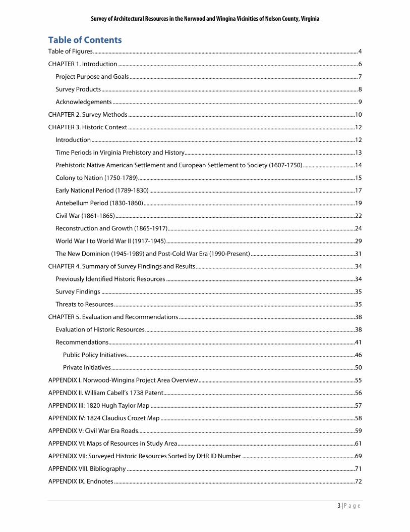
In 1887, 17 African American men became trustees of the newly-formed St. John Baptist Church (062-0236), and received a donation of land to serve as a building site from members of the Cabell family. This new building may have replaced an earlier brick church in the same vicinity (see the Civil War map for an “African church” on what is now Union Hill Road). The Reverend William Bailey, Jr. (1865-1941) served as pastor for most of his life. A new church was constructed nearby in 2009 to serve the needs of a growing congregation.
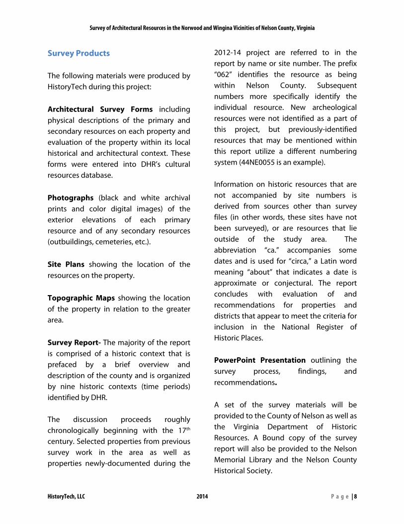
Also in 1887, William D. and Mary Cabell gave one acre of land on what is now Findlay Gap Road for the establishment of Bethany United Methodist Church (062-0237). Boatman and farmer John Donald contributed the $900 needed to construct the building, which was dedicated in September of that year. Like other 19th century meeting houses, the building had two front doors, two aisles, and divided pews to keep men and women separate during services. The Reverend Sidney
Sandridge changed the layout to a center-aisle configuration in the 1950s.
One of the most unassuming but culturally-significant buildings constructed during this period is the School House (062-5135-0053) at Rock Cliff, which was built circa 1880 by Dr. William A. Horsley. Said to be the first public school in Nelson County, Horsley’s daughters Nannie and Clara served as teachers that year, while their older sister Eliza was principal.20 Eventually, ownership of the school was transferred to the County of Nelson, which placed the property up for sale in the 1930s following an effort to consolidate county schools. At that time, it was purchased by Dr. William Andrew Horsley Gantt (1892-1980) and returned to the holdings of Rock Cliff.
By 1900, Nelson County was home to 99 grade schools for whites and 28 for black children (most of these were small, one-room, neighborhood schools like the one at Rock Cliff/Wingina). Around 1910, eight
Figure 25- St. John Baptist Church (062-0236) Figure 24- Bethany United Methodist Church (062-0237) prior to its 1950s expansion. (Image: Patricia Turner)
Survey of Architectural Resources in the Norwood and Wingina Vicinities of Nelson County, Virginia
HistoryTech, LLC 2014 P a g e | 27
Figure 26- This School House (062-5135-0053) is said to be the first public school in Nelson County
“combined” schools, which housed grade school and high school students, were built in key locations around the county, including Norwood.21 Built in 1909 by contractor Lucian Sheffield, the Norwood School (062-0229) is virtually identical to others built in Nelson County during the period, particularly the school at Shipman.22 The seven-bay façade displays two groupings of three tall nine-over-nine double-hung sash flanking a partially-glazed double entry door, which is sheltered by a small porch supported by turned wooden posts. Two dormers trim the hipped roof, which is topped by a louvered cupola.
By the early 20th century, the road network in the Norwood and Wingina neighborhoods had transformed into what is seen today. In the 18th and 19th centuries, the communities’ primary focus was the canal and river, and most roads led from the interior of the county to the James River rather than along the river itself. Through the Civil War period (See Appendix IV), Norwood was accessed from the north and west by Variety Mills Road and Norwood Road (as it is today), but Norwood Road did not travel very far to the east (the 1824 canal map shows that it at least connected to what is now Union Hill Road).
During much of the 19th century, Pine Hill Lane (Route 727), which now serves as a driveway for a few homes, was a principal thoroughfare known as the “Ridge Road” that led straight up the hill to the top of the ridge and ultimately connected with what is now Findlay Gap Road. Present-day Findlay Gap Road and Union Hill Roads converged in front of Old Norwood Plantation and then led to the James River at Cunningham’s Island. Further down river, a farm road on the Union Hill property provided access to the canal, and what is now Route 56 connected Lovingston, Wingina, and the Buckingham side of the James River. Later, what is now called Norwood Road was extended from Norwood all the way to Wingina, providing residents with an easy connection between the two communities.
Figure 27- A circa 1913 postcard featuring the Norwood School (062-0229) (Image: Corbis Images)
Survey of Architectural Resources in the Norwood and Wingina Vicinities of Nelson County, Virginia
HistoryTech, LLC 2014 P a g e | 28
The Chesapeake & Ohio Railroad constructed depots at both Norwood and Wingina around 1900. Unlike Warminster’s station which featured a large glazed cupola, these followed the typical design of the company’s stations of the period. The Norwood depot was slightly larger than Wingina, and had a massive hipped roof (rather than Wingina’s gable roof supported by brackets). Norwood’s depot was dismantled in the 1960s, and the facility in Wingina met its end a decade later.
Following the Civil War, Norwood was associated with several prominent religious leaders. W.A.R. Goodwin was born in Richmond in 1869, but his family moved to Altavista (062-0055) in Norwood the following year. Goodwin’s father John was born in Nelson County in 1843 when his father, Frederick Deane Goodwin, was Rector of Christ Church in Norwood. W.A.R. Goodwin remained in Norwood until 1885, when he entered Roanoke College. He later
became Rector of Bruton Parish in Williamsburg, and is best known for inspiring John D. Rockefeller, Jr. to fund the restoration of what would become Colonial Williamsburg.
George Wallace Ribble, a grandson of Frederick Deane Goodwin, was born at the Cabell-Ribble-Heath House (062-0224) in 1874. By 1902, he was working as an Episcopal missionary in Brazil, and then returned to the United States where he served as rector of churches in Roanoke and Halifax in Virginia as well as Bessemer, Alabama. His son, Watkins Leigh Ribble, would go on to become Archdeacon of the Episcopal Diocese of Virginia.
Several notable homes were constructed in the study area during the late nineteenth and early twentieth centuries, including Garnkirk (062-5135-0055) at Wingina. The house was constructed in 1901 by Wingina merchant, railroad contractor, and farmer
Figure 29- Wingina's Depot on the C&O Railroad (062-0034) (demolished)
Figure 28- This faint early 20th century photo of Norwood (looking east from the west side of the Tye River) shows Norwood Road raised high above the flood plain as it approaches the former steel truss bridge across the Tye. Stratton’s Store (demolished) is to the right of center, and the F.G. Peters Store (062-0216) is to the left of the bridge.
Survey of Architectural Resources in the Norwood and Wingina Vicinities of Nelson County, Virginia
HistoryTech, LLC 2014 P a g e | 29
Figure 30- Wingina Store and Post Office (062-0233)
John E. Johnson (son of Charles I. Johnson) and his new bride Eliza Dunlop. Eliza was descended from a long line of successful merchants in Petersburg, Virginia, and she named the house after one of the Dunlop family estates near Glasgow, Scotland. The house is a large, frame Queen Anne style dwelling with Colonial Revival features, but equally significant is the barn, which features a hipped slate roof with gabled wall dormers.
World War I to World War II (1917-1945)
Around 1920, the mercantile firm of C.I. Johnson & Son (then under the leadership of John E. Johnson) relocated their business from the south side of the James River in Buckingham County to Wingina in order to be closer to the railroad. The large frame store (062-0233) that they constructed was typical of rural commercial buildings of the time. Designed by noted Lynchburg architect Stanhope S. Johnson, the two-story frame building has a central entry flanked by
storefront windows on its east gable end.23 A one-story wing to the north was not included in the architect’s plans, and was either added during construction or at a later time. The two sections of the façade are united by a full-width shed-roofed porch. The building continues to operate as a post office today.
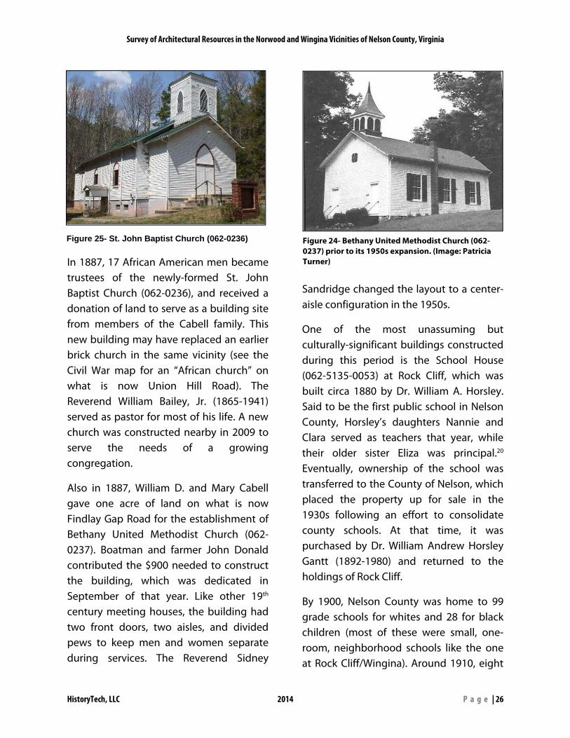
In 1922, Colonel Wirt Robinson (1864-1929), a professor of chemistry, mining, and geology at the United States Military Academy at West Point, constructed a summer home, which he called “Arrowhead” (062-5135-0051) on land that his father purchased thirty years earlier. Robinson was born at Fernley in Buckingham County, and was a descendent of the Cabell family. The one-and-a-half story brick dwelling has 6 chimneys and features a rear wing containing a kitchen and screened (now glassed-in) porch connected to the main house by a hyphen. A small brick guest cottage lies behind the house, and Col. Robinson’s private museum (062-5135-0050), also a gable-roofed brick building.
Figure 31- The barn at Garnkirk (062-5135-0055)
Survey of Architectural Resources in the Norwood and Wingina Vicinities of Nelson County, Virginia
HistoryTech, LLC 2014 P a g e | 30
Robinson was a graduate of West Point (Class of 1887), began teaching there in 1891, and wrote several books and papers on natural history. He hosted a number of scientists at his home to study insects, birds, archaeology, and other topics. Robinson retired from West Point in 1928, and died unexpectedly in early 1929. In 1940, over 20,000 archeological artifacts from Robinson’s collection were sold to the Jamestown Island Museum of Colonial National Historic Park. The collection was officially transferred to the Monacan Indian Nation in 2008. Robinson’s natural history collection consisting of over 1,300 birds went to the Smithsonian Institution.24
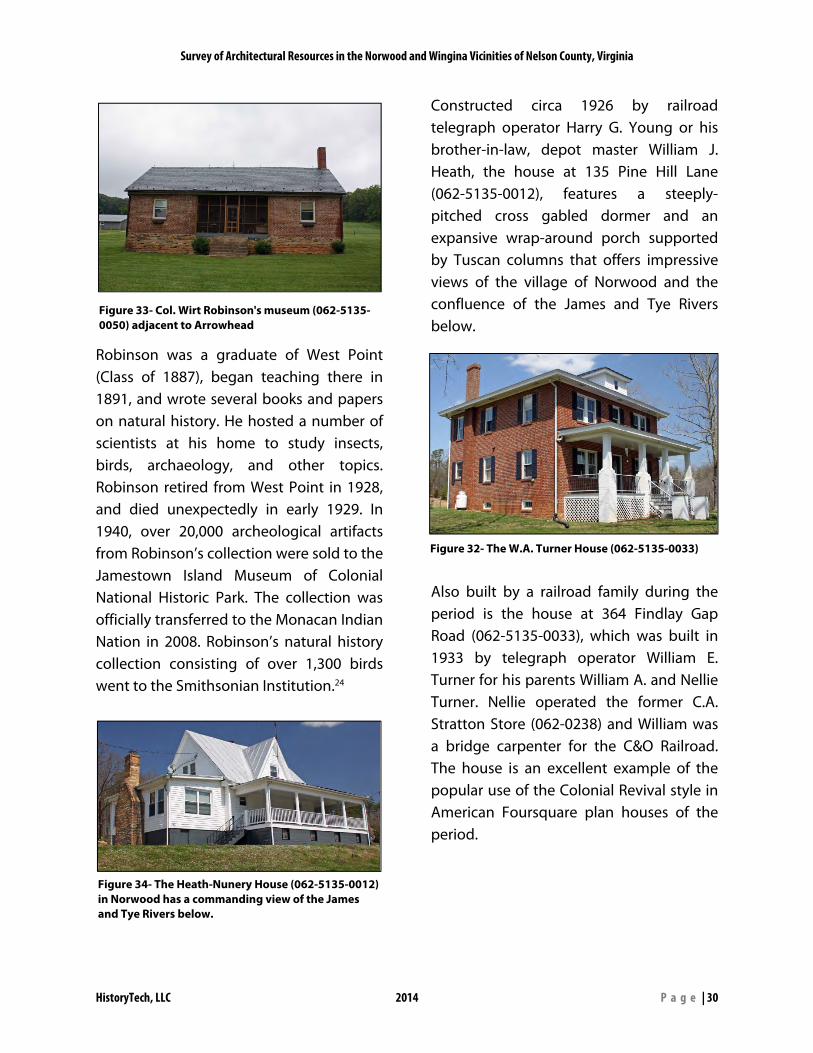
Constructed circa 1926 by railroad telegraph operator Harry G. Young or his brother-in-law, depot master William J. Heath, the house at 135 Pine Hill Lane (062-5135-0012), features a steeply-pitched cross gabled dormer and an expansive wrap-around porch supported by Tuscan columns that offers impressive views of the village of Norwood and the confluence of the James and Tye Rivers below.
Also built by a railroad family during the period is the house at 364 Findlay Gap Road (062-5135-0033), which was built in 1933 by telegraph operator William E. Turner for his parents William A. and Nellie Turner. Nellie operated the former C.A. Stratton Store (062-0238) and William was a bridge carpenter for the C&O Railroad. The house is an excellent example of the popular use of the Colonial Revival style in American Foursquare plan houses of the period.
Figure 33- Col. Wirt Robinson's museum (062-5135-0050) adjacent to Arrowhead
Figure 34- The Heath-Nunery House (062-5135-0012) in Norwood has a commanding view of the James and Tye Rivers below.
Figure 32- The W.A. Turner House (062-5135-0033)
Survey of Architectural Resources in the Norwood and Wingina Vicinities of Nelson County, Virginia
HistoryTech, LLC 2014 P a g e | 31
In 1936, Mary Cabell Callaway purchased a portion of her grandfather William D. Cabell’s Norwood Plantation and began operating a summer camp for girls. This was, however, not Norwood’s first use as a camp. In 1915, Mary’s parents, Maj. Charles Ellet Cabell and Nannie McCormick advertised that the “Norwood Home” would be opening that summer and accepting a “limited number of boys for summer vacation.25 In 1942, Mary advertised that Camp Norwood was an “ideal vacation spot for individuals, families, and house parties.” Amenities offered included horseback riding, tennis, swimming, fishing, and “professional dance instruction” (Mrs. Callaway’s specialty).26 In 1946, the camp became co-ed, and it continued operation until Mary’s death in 1952.
The New Dominion (1945-1989) and Post-Cold War Era (1990-Present)
Following World War II, the Norwood and Wingina communities experienced challenges similar to other rural villages in Central Virginia. As the popularity of the automobile increased, residents travelled further for employment, which ultimately shifted their shopping habits to towns like Lovingston, Amherst, and even to Lynchburg and Charlottesville. One by one, the stores in Norwood and Wingina closed. Nellie Turner operated the former C.A. Stratton Store into the early 1960s, and the Wood family continued the general store at Wingina until 1991 (the U.S. Post Office still operates there). The Chesapeake & Ohio Railroad discontinued passenger service in the corridor during the 1960s, which reduced the amount of commercial and tourism traffic through the area.
The area continued to serve as a residential community, however, and numerous homes have been built in Norwood and Wingina in the second half of the twentieth century. In the 1950s, Clarence Purdue constructed a one-story home (062-5135-0006) from bricks salvaged from the former Paul Stratton Store in Norwood. A more typical ranch style house of the period can be found at 8868 Norwood Road (062-5135-0048), which was built in 1967.
Figure 35- Advertisement for Camp Norwood in the Richmond Times-Dispatch, August 2, 1942.
Survey of Architectural Resources in the Norwood and Wingina Vicinities of Nelson County, Virginia
HistoryTech, LLC 2014 P a g e | 32
In August of 1969, the remnants of Hurricane Camille made their way up the Blue Ridge Mountains from the Gulf of Mexico before becoming stationary over central and western Virginia. The storm dropped a world record 27 inches of rain on Nelson County over a 3-hour period, and more over the course of the storm.
Many communities were flooded by forceful waters which destroyed over 133 public bridges and countless houses. 153 people were killed by the storm, and the bodies of many were never located. By 1969, many buildings that may have been in the flood plain near Norwood and Wingina had either been demolished or abandoned, and thus the storm’s toll on the study area’s building stock was not as severe as in some other areas of the county. The Frederick G. Peters Store at the intersection of Variety Mills Road and Norwood Road was damaged, and the Norwood Road bridge over the Tye River was completely swept away. An area native recalled that the circa 1905 steel bridge at Wingina had been condemned just before the flood, but ironically, was
one of the few river crossings that survived the torrent.
In the mid-1980s, the discovery of buried 18th and 19th century batteaux in downtown Richmond sparked a renewed interest in early navigation on the James River. The Virginia Canals and Navigations Society, which had been founded in 1977, furthered its efforts to study the James River & Kanawha Canal system, producing numerous maps and cultural resource reports.
Figure 36- Hurricane Camille destroyed the Tye River road bridge at Norwood. The damaged porches of Peters Store (062-0216) can be seen in the lower left corner
Figure 37- The house at 8868 Norwood Road (062-5135-0048) is a good example of a late 20th century ranch style home
Survey of Architectural Resources in the Norwood and Wingina Vicinities of Nelson County, Virginia
HistoryTech, LLC 2014 P a g e | 33
In 1986, groups from throughout Central Virginia constructed reproduction batteaux based on the designs of those that were discovered in Richmond, and travelled down the James River from Lynchburg to Maidens Landing. The James River Batteau Festival quickly became a hit, and the eight-day event occurs in June of each year. Wingina was reborn as a household name amongst river buffs, and the fields just upriver from the Route 56 bridge has become the site of the flotilla’s third night on the river. Local musicians, organizations, and spectators gather to celebrate the area’s river heritage.
Into the twenty-first century, community organizations like the Nelson County Historical Society have continued to promote public interest in Norwood and Wingina, and a number of successful home tours in the area have been conducted. In 2011, the society dedicated a Virginia Historic Highway Marker at Christ Church in Norwood in honor of the Reverend W.A.R. Goodwin (1869-1939).
Several new buildings have been constructed during this time, including a new St. John Baptist Church (062-5135-0029) (on a different site from the historic church), and the houses at 9721 Norwood Road (062-5135-0027) and 534 James River Road (062-5135-0071). There is also a strong interest in bringing the area’s historic resources back to life. For example, Montezuma (062-0010), which had been vacant for a considerable period, was recently renovated.
Figure 39- A recreated James River Batteau prepares to land at Wingina
Figure 38- Dedication of the W.A.R. Goodwin marker in Norwood (Photo credit: Victoria Mininger, nelsoncountylife.com)
Survey of Architectural Resources in the Norwood and Wingina Vicinities of Nelson County, Virginia
HistoryTech, LLC 2014 P a g e | 34
CHAPTER 4. Summary of Survey Findings and Results
Previously Identified Historic Resources The systematic documentation of the area’s historic resources began in the late 1930s with the work of the Virginia Historical Inventory of the Works Progress Administration, a state and federal collaboration to research, describe, photograph, and map the Commonwealth’s historic resources, principally elite houses dating to before the Civil War. The next major phase of survey in Nelson County began in the mid- to late 1970s with the survey of scores of resources under the guidelines of the Virginia Historic Landmarks Commission, predecessor of the DHR. Additional resources across the county were surveyed in 1993 by consultants working with the Thomas Jefferson Planning District Commission and in 1998 by consultants working with the County of Nelson, Nelson County Historical Society, and DHR. Prior to the 2012-13 survey, approximately 35 resources in the Norwood and Wingina areas had been surveyed. Compared to other similar areas, Norwood and Wingina’s historic resources were fairly well represented in the statewide inventory prior to the commencement of this project. However, the level of documentation of the approximately 35
previously recorded properties varied widely. Some have been documented with complete intensive level surveys or have been listed in the National Register of Historic Places, and a relatively complete profile of these resources is available. However, other properties are only identified with a single photograph or perhaps just a marked location on a map. In many cases, previously recorded resources in the area had been incorrectly located on maps, which caused duplicate survey files to be created in some cases. Understanding of Norwood and Wingina’s historic resources has also benefited from the nomination of properties to the Virginia Landmarks Register and the National Register of Historic Places. The register reports, which contain detailed historical and architectural information, typically result from sponsorship by individual property owners. This has created a bias towards elite residences, although information on auxiliary farm buildings and other more vernacular resources is often included. To date, 16 individual resources and two districts within Nelson County have been listed. Norwood and Wingina area properties (with their DHR site numbers) presently listed in the state and national registers are:
Montezuma (062-0010) (listed in 1980) Soldier’s Joy (062-0015) (listed in 1980)
The nomination reports for these properties may be viewed online at the DHR website (www.dhr.virginia.gov).
Survey of Architectural Resources in the Norwood and Wingina Vicinities of Nelson County, Virginia
HistoryTech, LLC 2014 P a g e | 35
Selected information from the nominations is presented throughout the survey report.
Survey Findings For this project, the survey team documented 73 individual resources in the Norwood and Wingina areas. The list of properties surveyed as a part of this project is included in Appendix VII, and an overview map showing the distribution of surveyed resources is included Appendix VI. Of the 73 properties that were surveyed, 55 are considered to be contributing to the integrity of a possible future state and national historic district. 19 are considered to be non-contributing to the historic character of a possible district, and 2 have been previously listed in the National Register (these automatically contribute to a potential district, but are counted separately in a formal nomination). An archaeological assessment of properties was not a part of the project scope.
Threats to Resources
Like most communities, Norwood and Wingina have lost a significant amount of historic resources over the years. In more densely-populated areas, historic buildings are often demolished in order to make room for new construction, which may become historic in its own right over time.
Rural and urban communities alike must also deal with loss of historic resources due to fires, floods and other natural disasters, and neglect.
As described previously, the 1870 and 1969 floods certainly took their toll on Norwood and Wingina. However, by 2013, most extant resources that remain in the area lie outside of the normal flood plain. Notable exceptions to this are the Fredericks G. Peters Store (062-0216) in Norwood and the Wingina General Store and Post Office (062-0233), which remain susceptible to damage by flood water.
Fires, both accidental and criminal, have plagued historic properties in the area for centuries. The D.E. Nelson Store (062-0218) in Norwood burned under suspicious circumstances in the early 1990s, leaving only its stone foundation.
In December of 2012, during the current survey project, the main house at Old Norwood (062-0213) burned to the
Figure 40- The Nelson Store (062-0218) burned in the early 1990s. Only its foundation remains.
Survey of Architectural Resources in the Norwood and Wingina Vicinities of Nelson County, Virginia
HistoryTech, LLC 2014 P a g e | 36
ground. This, of course, was a significant loss to the owners of the property as well as the community as a whole. Fortunately, the house had been documented by several architectural surveys in the preceding two decades.
In some cases, historic resources can be physically removed from a community. Col. William Cabell, Sr.’s Union Hill was dismantled and moved to Goochland County by Mr. and Mrs. Royal E. Cabell in 1982, leaving only the cemetery (a large house was built on its site ten years later). Like the cemetery at Liberty Hall near Warminster, the Union Hill cemetery had been deeded decades earlier to the Cabell Foundation, Inc., which is responsible for the care and maintenance of the site.
A number of resources within the study area have suffered from alterations or additions that are inappropriate in scale or material. In a few cases, buildings have been renovated so significantly that their eligibility as a historic resource may be in question. The Secretary of the Interior’s
Standards for Rehabilitation provide sound guidance for property owners who wish to make changes or repairs to historic properties.
Infill by new construction is also a challenge in the Norwood and Wingina area. Sweeping views of the James River Basin combined with a general proximity to the cities of Lynchburg, Charlottesville, and Richmond have caused the area to be popular for construction of large country houses. Care should always be taken to ensure that new construction is compatible with the natural and cultural landscape of the area (this does not necessarily mean that a new building needs to “look historic” in order to fit in).
The area’s greatest threat to historic resources, however, is the deterioration and decay of vacant properties. Several resources, including the Frederick G. Peters Store (062-0216), and St. John Baptist Church (062-0236) are in fair condition, but are vacant and thus vulnerable to vandalism or further decay. More than half a dozen other resources, including
Figure 41- Old Norwood (062-0213) burns on December 9, 2012 (Image: Archer Guy Minardi)
Figure 42- This dwelling (062-0232) on the west side of the Tye River is one of several that have been demolished since the last survey was conducted in the 1990s
Survey of Architectural Resources in the Norwood and Wingina Vicinities of Nelson County, Virginia
HistoryTech, LLC 2014 P a g e | 37
Altavista (062-0055), Christ Church Rectory (062-5123), and the Matthews House (062-0223) are all in ruinous condition.
If deterioration of historic resources is allowed to continue unchecked, demolition ensues. A number of buildings have been demolished since the architectural surveys of the 1990s were conducted.
There are, however, some success stories in the area. As previously noted, Soldier’s Joy (062-0015) was being used as a hay barn in the 1920s, but has been restored and is listed in the National Register of Historic Places. Montezuma (062-0010), also listed in the National Register, was long vacant, but has recently been purchased and restored. In September of 2012, a storm caused significant damage to Christ
Church (062-0003), which is also vacant. Members of the community promptly banded together to repair the building.
Figure 44- Christ Church (062-0003) was damaged by a September 2012 storm (photo courtesy: J.P. Harvey, nelsoncountylife.com)
Figure 43- This post-1920 photograph shows the Wingina Store and Post Office (left), C&O Depot (right), and at least two other commercial buildings. Only the Wingina Store remains today. (Image: Barbara Wood)
Survey of Architectural Resources in the Norwood and Wingina Vicinities of Nelson County, Virginia
HistoryTech, LLC 2014 P a g e | 38
CHAPTER 5. Evaluation and Recommendations
Evaluation of Historic Resources It is important to note that the historic context within this report is not intended to be a complete history of the area, and does not begin to cover every significant person or event that has had an impact on Norwood and Wingina. The context presented within is specifically geared towards documenting the developmental history of the area and how extant historic resources relate to it. While the authors of this report have made a concerted effort to include information on a variety of groups that helped build the community. It would be relatively easy to compile a history on the area simply by following the Cabell family and its descendants (in fact, many of the published works about the area were produced by Cabell descendants), but the intent of this report is not to be “Cabell-centric.” The fact remains, however, that this prominent family controlled most of the land within the study area from the early 18th century well into the 20th century, and their impact on local, state, and national history cannot be dismissed. Because this report is not designed to be a comprehensive history of the Norwood and Wingina areas, it does not focus on many resources that are no longer extant. While community histories are valuable for documenting locations of former buildings, the purpose of this study is to evaluate the area’s eligibility for possible
future listing in the state and national registers. This process requires that attention be paid to the integrity of extant resources, and typically, resources that have been lost are mentioned only when they relate to the area’s developmental history or architectural context. A historic resource is typically at least fifty years old, although resources of lesser age may qualify if they can be shown to have exceptional significance. A historic resource can be a building, structure (bridge, water tower), object (fountain, sculpture), site (battlefield, cemetery), district (a group of related resources), feature (street lights, clock tower), or open space (park, village green) that is significant in history, architecture, archaeology, engineering, or culture at the local, state, or national level. A historic resource should retain a high degree of integrity that is comprised of seven qualities: Location- the place where the resource was originally constructed or where a historic event took place. Moving a resource from its original location, except in rare cases, destroys the relationship between the resource and its historic association resulting in the loss of its integrity. Design- the combination of elements that create the form, plan, space, structure and style. Design is a result of planning, function, technology, and/or aesthetics. Setting- the physical environment of a historic property. Setting is how and where
Survey of Architectural Resources in the Norwood and Wingina Vicinities of Nelson County, Virginia
HistoryTech, LLC 2014 P a g e | 39
a resource is situated in relationship to natural or man-made elements such as topography, vegetation, paths, open space or relationships to other buildings. Workmanship- the physical evidence of the craft of a particular culture or people during any given period in history or prehistory. This could include stone masonry, carving, joinery, and decorative finishes. Feeling- the expression of the aesthetic or historic sense of a particular period of time. Feeling is the result of the combination of the presence of design, materials, workmanship and setting. Association- the direct link between a resource and a historic event or person. Materials- the combination of physical elements of a particular time period and/or pattern. When evaluating materials look at roofing, foundation, siding, windows and doors, porches and architectural details. A property should retain the majority of its original materials and distinguishing features that date from its period of historic significance. Example for evaluation of materials: A proposed district contains an 1870s Italianate house that retains its full-length front porch, segmental arched windows and window hoods, and decorative brackets, but its cupola has been removed. The cupola is just one of the major features that make this an Italianate style house. Because the house still retains the majority of the stylistic elements that define it as Italianate, it would still be considered a contributing historic resource. However, if
all the detail elements (porch, window hoods, cupola and brackets) had been removed when the house was vinyl sided in the 1980s and an addition was placed on the house so that its massing was changed, it would no longer retain its material integrity and would be considered non-historic. Some additions and changes to historic properties acquire historic significance over time. For example, an 1870s storefront was modernized in 1932 with Art Deco Carrera glass, the alteration has probably become significant in its own right as an example of the Art Deco style. It is sometimes difficult to assess changes to simple vernacular buildings such as an upright and wing gable front house that has been vinyl sided. In this situation an assessment might include determining the amount of ornamentation the property originally had and what is now missing. Chances are there weren’t many “extras” on the property in the first place and if it retains its original window and door openings and massing it might still be considered historic.
Survey of Architectural Resources in the Norwood and Wingina Vicinities of Nelson County, Virginia
HistoryTech, LLC 2014 P a g e | 40
Resources within the study area were evaluated for their classification as contributing or non-contributing resources within a potential state and national historic district. Contributing resources add to the historic association, historic architectural quality, or archaeological values for which a property is significant because they were present during the period of significance, relate directly to the documented significance, and possess historic integrity. Non-contributing (non-historic) resources do not add to the historic architectural qualities or historic association of a district because they were not present during the period of significance, do not relate to the documented significance, or due to alteration, additions, and other changes they no longer possess historic integrity. By developing the historic context of a potential district through determining the
significant events, people and time periods associated with it and assessing the physical integrity of the resource, we can then apply the eligibility criteria developed by the Secretary of the Interior for the National Register of Historic Places. The four main criteria are: Criterion A: Property is associated with events that have made a significant contribution to the broad patterns of our history.
Criterion B: Property is associated with the lives of persons significant in our past.
Criterion C: Property embodies the distinctive characteristics of a type, period or method of construction or represents the work of a master, or possesses high artistic values, or represents a significant and distinguishable entity whose components lack individual distinction.
Criterion D: Property has yielded, or is likely to yield information important in prehistory or history.
Figure 45- Distribution of Contributing (blue) and Non-contributing (red) primary and secondary resources within the study area
Survey of Architectural Resources in the Norwood and Wingina Vicinities of Nelson County, Virginia
HistoryTech, LLC 2014 P a g e | 41
Recommendations
Historic District Designation
Based on the architectural fieldwork and historical research completed for this project it is recommended that the Norwood and Wingina area be nominated to the Virginia Landmarks Register and National Register of Historic Places as a district under Criterion A for its association with events that have made a significant contribution to broad patterns of history and under Criterion C for its embodiment of district architectural characteristics.
A potential Norwood-Wingina district may qualify under these two criteria (A and C) in the areas of agriculture, architecture, commerce, education, settlement patterns, religion and transportation.
Two different district configurations are recommended for consideration.
Boundary Option 1 would include the entire area shown within the black polygon in the map on the previous page. The district would contain all resources surveyed as a part of this project, and would stretch from Forkfield (062-0054) in the west to River Circle Farm (005-5135-0057) in the east. A district based on these boundaries comprehensively represents the history and extant historic architecture of the area. In addition, it comprises the entirety of the James River bottomland stretching between the two abovementioned farms. This flat, fertile floodplain supported small farms and large
plantations, which led to the development of the villages of Wingina and Norwood. These advantages of this district configuration (Option 1) far outweigh the few disadvantages, which include the higher ratio of non-contributing to contribution resources in the central portion of the district.
This comprehensive approach is highly recommended, and, of the options presented here, best follows the National Park Service’s “Guidelines for Evaluating and Documenting Rural Historic Landscapes” (National Register Bulletin 30).
A district with boundaries presented in Option 1 would have a period of significance of circa 1785 (representing the earliest documented year of construction for an extant resource in the district) to 1964, which is 50 years from today and represents the general period in which Norwood and Wingina lost passenger rail service and their prominence as community centers.
Survey of Architectural Resources in the Norwood and Wingina Vicinities of Nelson County, Virginia
HistoryTech, LLC 2014 P a g e | 42
Boundary Option 2 would encompass a much tighter area around the village of Norwood (see map above). Outlying properties such as Forkfield (062-0054) and Montezuma (062-0010) would not be included in a village-oriented district because they did not develop solely because of their proximity to New Market/Norwood. The district would not include the cluster of resources on the south side of the Tye River because they are non-contributing due to their age, have been altered in a manner that obscures their historic fabric, or have been demolished. The advantage of a smaller district such as this is that it 1) improves the ratio of contributing vs. non-contributing resources and 2) requires the acceptance of a smaller number of property owners (if DHR receives objections from a majority of property
owners in a proposed district, the district will not be approved). While these boundaries (Option 2) would succeed in celebrating the history and architecture of Norwood proper, many resources that also contribute to the story of Nelson County's development along the James River would be omitted.
A district with the boundaries described in Option 2 would have a period of significance of circa 1840 (the beginning of the decade of construction of several important resources in the district, including Christ Church and the Frederick G. Peters Store) to 1964, which is 50 years from today and represents the general period in which Norwood lost passenger rail service and its prominence as a community center.
Figure 46- District Boundary Option #2 showing a tighter district encompassing only the village of Norwood. Blue dots represent contributing resources. Red dots represent non-contributing resources.
Survey of Architectural Resources in the Norwood and Wingina Vicinities of Nelson County, Virginia
HistoryTech, LLC 2014 P a g e | 43
National, State, and Local Historic Districts
It is important to note that this report is recommending that the area be listed at only the state and national (not local) levels.
State (Virginia Landmarks Register) and national (National Register of Historic Places) are purely honorary in nature, and serve to recognize the history of an area while encouraging stewardship of historic resources within the district. Unless property owners voluntarily seek incentives such as the State & Federal Historic Rehabilitation Tax Credit program, no restrictions are placed on what they do to or with their historic properties. If a property is destroyed or severely altered so as to negate its historic integrity and eligibility for listing, it will simply be reclassified as non-contributing (if listed as part of a district) or de-listed (if listed individually). No agency would prevent the owner from making these changes based on its listing in the state and national registers.
Rather than being honorary, local historic districts are zoning ordinances passed by the town, city, or county. Like any zoning ordinance, a local historic district would place some degree of restrictions on historic properties within. While local historic districts have their place in historic preservation, the authors of this report do not think that local designation is appropriate in most rural historic district
settings, and certainly not for Norwood and Wingina.
This issue is being mentioned here because the Natural, Scenic, and Historic Resources section of the Nelson County Comprehensive Plan encourages the “establishment of local historic districts in support of the county’s tourism program and to protect their historical, architectural, and cultural significance.” It is thought that by local, the Comprehensive Plan means small or localized (rather than expansive rural districts that cover tens of thousands of acres). However, in case the plan does indeed recommend the establishment of local historic district zoning within the county, the authors of this report wish to make an argument against such designation for Norwood and Wingina.
Individual National Register Listing
In the event that the community chooses not to pursue state and local historic district designation, there are several properties within the study area that may qualify for individual listing in the state and national registers. These include:
Christ Church (062-0003) – One of the oldest remaining brick churches in Nelson County. A careful study of the building’s architectural significance would determine if its qualities overcome the National Register Criteria Consideration regarding religious properties (NRHP Criteria C).
Survey of Architectural Resources in the Norwood and Wingina Vicinities of Nelson County, Virginia
HistoryTech, LLC 2014 P a g e | 44
Forkfield (062-0054) – Outstanding Antebellum architecture (NRHP Criterion C)
Frederick G. Peters Store (062-0216) – Important as one of only a few Antebellum stores remaining in Nelson County (NRHP Criteria A, C)
Arrowhead (062-5135-0051) & Arrowhead Museum (062-5135-0050) – Potentially significant for architecture and purpose along with association with early 20th century natural history studies and Col. Wirt Robinson (NRHP Criteria A, B, C)
Rock Cliff (062-0438) – Determined to be eligible for listing in the NRHP in 2003 under National Register Criteria A, B, C, and D
Garnkirk (062-5135-0055) – Potentially significant under NRHP Criterion C for architecture, particularly its barn
Wingina Store & Post Office (062-0233) – Potentially significant under NRHP Criterion A for its role in early 20th century commerce and under Criterion C as an architecturally-refined store designed by Stanhope S. Johnson
This is not necessarily a comprehensive list, and other properties may also be potentially eligible. The above list is speculative, and closer evaluation of the resources’ interiors and exteriors would need to be conducted as a part of DHR’s preliminary evaluation process (via submission of a Preliminary Information Form).
Inclusion of Warminster, Midway Mills, Variety Mills, and Gladstone
At the June 2014 public meeting, several attendees requested that the nearby communities of Warminster and Midway Mills (to the east), Variety Mills (to the north), and Gladstone (to the west) be considered for inclusion together with Norwood and Wingina in a potential historic district. Their reasoning was that most of these communities were included in Dr. William Cabell’s original 1738 patent and that they contained historic buildings that played a key role in the development of the area.
The project team conducted windshield surveys of these areas (as well as Virginia Route 56 in Buckingham County) in 2013 and again in 2014 following the public meeting. While it is true that these areas were and are an important part of the story of Nelson County and were closely connected with the Cabell Family, very few architectural resources remain.
Midway Mill (062-0023) was individually listed in the National Register of Historic Places, but was de-listed in 2001 following
Figure 47- Arrowhead may be individually eligible for National Register listing because of its architectural character and association with Col. Wirt Robinson
Survey of Architectural Resources in the Norwood and Wingina Vicinities of Nelson County, Virginia
HistoryTech, LLC 2014 P a g e | 45
its destruction in 1998. While the Simpson House and its outbuildings remain (along with several ruinous buildings in the area), it is the project team’s opinion that there is not sufficient density of extant historic resources at Midway Mills to justify extending the eastern boundary of the Norwood-Wingina District 1.17 miles downriver.
Similarly, there are very few extant historic architectural resources associated with the once-thriving town of Warminster. Liberty Hall burned in 1895, and the stores, tavern, post office, and railroad depot are all gone. The significant homes of Edgewood (062-0004) and Bon Aire (062-0089) are in the vicinity, but they are already individually listed in the National Register of Historic Places. The project team does not feel that there is enough density of extant resources to justify extending the boundaries of the Norwood-Wingina District an additional two miles past Midway Mills (over three miles in total) to include Warminster.
Similar evaluations were conducted for Variety Mills and the Gladstone area. Based on the project team’s interpretation of the National Park Service guidelines for creating historic district boundaries, there is little justification for extending the proposed Norwood-Wingina district boundaries this far. The boundaries could, however, be adjusted if extant resources are discovered that are very close or adjacent to the proposed district, but the project team feels that it has conducted a fairly thorough survey of the area.
Resources Not Surveyed in 2012-2014
Due to property access issues, the following resources within the proposed Norwood-Wingina district were not surveyed, and should be surveyed prior to the completion of a National Register nomination:
9187 Norwood Road 10599 Norwood Road (non-
contributing) 10875 Norwood Road (non-
contributing) 374 Findlay Gap Road 100 Round Top Lane
In addition, Nelson County GIS records indicate that a cemetery exists to the southwest of 10352 Norwood Road (see yellow star) adjacent to the CSX railroad tracks. The occupant of 10352 Norwood Road did not know of a cemetery in that location, and there are numerous errors in the GIS mapping system in the area, but the presence of a cemetery should be confirmed.
Survey of Architectural Resources in the Norwood and Wingina Vicinities of Nelson County, Virginia
HistoryTech, LLC 2014 P a g e | 46
Public Policy Initiatives
Nelson County should consider appointing a citizens’ historic preservation advisory committee to develop strategies for implementing the recommendations of this report and, in general, to assist and advise the county and its citizens in preservation matters. It is recommended that historic and scenic preservation strategies called for in Nelson County’s 2002 Comprehensive Plan continue to be a focus. These include: Economic Development Goal: Support and encourage tourism as a viable means to diversify the local economy.
Principle: Promote historic sites that are accessible to the public as part of the tourist economy.
Natural, Scenic, and Historic Resources Goal: Protect the county’s scenic resources as essential to the county’s rural character, economic strength and quality of life.
Principle: Protect the county’s scenic roadways by designating them as State Scenic Byways and by adopting a local scenic byways ordinance as needed. Principle: Maintain areas of scenic beauty of the county’s waterways and rivers as natural resources and in support of the county’s tourism program. Principle: Promote the preservation of the viewsheds of scenic vistas as an
important part of the county’s tourism program. Principle: Discourage ridgeline development.
Goal: Preserve and protect the historic character and features of Nelson County.
Principle: Recognize and honor stewardship of historic properties and sites through, for example, the Historic Designation Program and through formal recognition by the Board of Supervisors. Principle: Encourage the establishment of local historic districts in support of the county’s tourism program and to protect their historical, architectural, and cultural significance. Lovingston and Schuyler, in particular, are appropriate for historic district designation [see discussion of historic districts in the “Recommendations” section]. Principle: Promote architectural compatibility of new development, including infill development, in designated development areas where significant historic resources exist.
Rural Conservation Goal: Maintain the rural character of Nelson County.
Principle: Protect sensitive rural areas such as steep slopes, river and stream corridors, prime farmland, old growth forests, and historic sites from encroaching development by
Survey of Architectural Resources in the Norwood and Wingina Vicinities of Nelson County, Virginia
HistoryTech, LLC 2014 P a g e | 47
discouraging rural growth in areas adjacent to these sensitive areas. Principle: Protect rural scenic roadways through vegetative buffers between the roadways and new rural subdivision growth. Principle: Protect scenic views and vistas by encouraging the siting of new buildings in conformance with the existing topography and into the existing landscape and vegetation.
The County should consider implementing the “Rural Village Development Model” as described in the Comprehensive Plan for the core area of Norwood. Currently, only the villages of Shipman and Schuyler are associated with this development model. In the remainder of the study area, the Comprehensive Plan’s principles for preservation of rural character should be followed: Historic sites, including farmhouses,
outbuildings and barns should be incorporated into developments
Limit development on critical slopes in order to maintain the balance between slope, soils, geology, and vegetation.
Scenic vistas should be protected by limiting development and through height limits on new buildings
River and stream corridors, especially floodplains and wetlands, should remain undeveloped
To protect rural roadways, development should be well buffered
from the road with existing vegetation preserved or vegetative buffer planted, and with limited access points
Other suggested historic preservation activities that Nelson County should consider include: Educate property owners as to
preservation incentives and the mechanisms of registering and/or preserving the County’s historic resources.
Promote historic tourism with encouragement for the County to develop site appropriate infrastructure, such as underground utilities, narrow roads, and building facade standards.
Explore incorporating historic preservation incentives into the County’s zoning ordinance.
Evaluate the need for and feasibility of creating additional historic districts/sites within the County.
Consider identifying and publicize a heritage trail system within the County.
Work with VDOT and DHR to add historic roadside markers as identified by the County historical society.
Geographic Information Systems
As Nelson County further develops its Geographic Information Systems (GIS) capabilities, it is recommended that data regarding historic resources be included as
Survey of Architectural Resources in the Norwood and Wingina Vicinities of Nelson County, Virginia
HistoryTech, LLC 2014 P a g e | 48
a data layer in the County’s system. Data for the properties surveyed as a part of the 2012-14 project has been provided to the County. The County may seek data for all catalogued resources from the Virginia Department of Historic Resources.
Certified Local Government Program Nelson County may consider expanding its local preservation program through the Certified Local Government Program (CLG). The program was created by the National Historic Preservation Act of 1966, as amended in 1980, and establishes a partnership between local governments, the federal historic preservation program, and the Department of Historic Resources (DHR). The program allows DHR, as the State Historic Preservation Office, to recommend for certification local governments that have put key elements of a sound local preservation program in place in their communities. Designation as a CLG gives a local governments a way to participate more formally in the state and national historic preservation programs. General requirements for certification are identified in the federal program; specific requirements for the Virginia program have been established by DHR. Goals of the Virginia CLG program are threefold: Promote viable communities through
preservation Recognize and reward communities
with sound local preservation programs
Establish credentials of quality for local preservation programs
Requirements for the Virginia CLG program include: A historic district ordinance that
defines district boundaries, establishes a review board, identifies actions that must be reviewed and standards for review, and in general provides for the protection of local historic resources [Note: this type of ordinance may not be appropriate for all districts within Nelson County, and is not thought to be appropriate for Norwood and Wingina]
A preservation commission or review board that administers the ordinance and that works as an advocate for preservation in the locality
Continuation of a survey of local heritage resources
Public participation in the local heritage stewardship program
Satisfactory performance of responsibilities
DHR is currently reviewing the program requirements to identify other local government planning efforts that promote heritage stewardship activities and that contribute to an effective local preservation program. As a result of this review, some of the requirements for the CLG program may be amended. Benefits of participation in the CLG program include:
Survey of Architectural Resources in the Norwood and Wingina Vicinities of Nelson County, Virginia
HistoryTech, LLC 2014 P a g e | 49
CLGs assume a formal role in the identification, evaluation and protection of the community’s heritage resources.
CLGs review and comment on national register nominations from their jurisdictions.
CLGs receive technical assistance from DHR and the National Park Service.
CLGs learn from each other by sharing experiences, concerns, and solutions to problems.
CLGs are eligible to apply for matching grants for preservation programs from a 10% share of Virginia’s annual federal appropriation.
For more information about the CLG Program, contact the VDHR CLG Program Manager or visit the web site at: www.dhr.virginia.gov
Survey of Architectural Resources in the Norwood and Wingina Vicinities of Nelson County, Virginia
HistoryTech, LLC 2014 P a g e | 50
Private Initiatives
National Register of Historic Places/Virginia Landmarks Register Designation Virginians are justly proud of their history and have worked hard to preserve its tangible reminders. Virginia’s rich heritage is reflected in its architecture—some of the best in the United States—as well as in its many archaeological sites, battlefields, and historic districts. The Department of Historic Resources (DHR) administers two programs designed to recognize our resources and to encourage their continued preservation: the National Register of Historic Places and the Virginia Landmarks Register. The National Register of Historic Places, established in 1966 and managed by the National Park Service, is the official list of structures, sites, objects, and districts that embody the historical and cultural foundations of the nation. More than 80,000 historic resources of all kinds (including 700,000 contributing buildings in historic districts) are listed nationwide. The National Register of Historic Places already includes more than 2,000 properties in Virginia. For more information on the national register, a weekly list of registered properties, educational programs, and publications, visit the National Register of Historic Places Web site at www.cr.nps.gov/nr
The Virginia Landmarks Register, also established in 1966 and managed by the Department of Historic Resources, is the state’s official list of properties important to Virginia’s history. The same criteria are used to evaluate resources for inclusion in each register. Periodically, the department publishes an updated edition of The Virginia Landmarks Register, a book that contains a photograph and description of each property on the register. Nomination forms for properties to be considered at quarterly meetings of the Virginia Board of Historic Resources and the Virginia State Review Board are posted in the Board Activities area of the DHR web site. What are the benefits of registration? Registration is an honor bestowed on historic properties by the state and federal governments. It recognizes the historic value of a property and encourages present and future owners to continue to exercise good stewardship. Owners of registered properties may donate historic preservation easements (which can reduce real estate taxes), qualify for the state and federal historic rehabilitation tax credits, receive technical assistance from department staff for maintenance and rehabilitation projects, and purchase plaques that mark the property’s significance.
Survey of Architectural Resources in the Norwood and Wingina Vicinities of Nelson County, Virginia
HistoryTech, LLC 2014 P a g e | 51
Is registration expensive? No fees are charged by DHR for any part of the registration process. Many property owners successfully complete the Preliminary Information Forms and National Register of Historic Places nominations with advice from department staff. Others, however, may wish to pay a consultant to do the work for them. We suggest that they review DHR’s Consultants Directory and contact several consultants to compare estimated costs. There are costs associated with ordering a register plaque for a historic property. Will anyone be able to stop me if I want to alter or tear down my property once it’s registered? Not as a result of registration. Property owners who donate historic preservation easements, participate in the federal or state incentive programs (such as tax credits) must abide by certain restrictions on alterations or demolitions associated with those programs. Otherwise, only local building codes and permit requirements must be satisfied, as with any property. Some friends live in a historic district, and they tell me that they have to get permission from a board to repair their porch or paint their house. Will I have officials looking over my shoulder if I register my house? No. Only locally designated historic districts are subject to local zoning ordinances and procedures. Sometimes, a property or district may be listed at the national, state, and local levels
but it is only the local designation that places restrictions on private owners. Do I have to open my property to the public if it is registered? No. Listing in the National Register of Historic Places or the Virginia Landmarks Register does not require that you open your house to the public. Will registration or listing increase or decrease my property values and tax burden? Many factors affect the value of real estate: location, improvements, supply and demand, zoning, surroundings, local and national economic conditions, business cycles, and actions of national, state, and local governments. Changes in any of these factors may increase or decrease the value of property. Registration per se appears to have little effect, although one would expect well-kept, attractive, older properties and neighborhoods to experience rising values over the long run. Can a property be nominated individually if it is within a district? Yes. However, property owners in districts already can receive the same benefits as owners of individually listed properties. In other words, if a property is listed as a contributing structure within the district, it is already "just as registered" as if it were listed individually. Guidance in evaluating the eligibility of a property for listing is available from the Capital Regional Preservation Office at VDHR.
Survey of Architectural Resources in the Norwood and Wingina Vicinities of Nelson County, Virginia
HistoryTech, LLC 2014 P a g e | 52
State & Federal Rehabilitation Tax Credits The preservation of historic buildings benefits communities. Historic places connect us to our heritage and enrich the quality of our lives in countless intangible ways, but their preservation also provides demonstrable economic benefits. Through the federal and state Rehabilitation Tax Credit programs, property owners are given substantial incentives for private investment in preservation, resulting in enormous advantages to the public. Since the state program's inception in 1997, the program has spurred private investment of approximately $1.5 billion in the rehabilitation of more than 1,200 landmark buildings. This investment in turn has generated an economic impact of nearly $1.6 billion in the Commonwealth and created more than 10,700 jobs and $444 million in associated wages and salaries (for more information, see the January 2008 publication Prosperity through Preservation). This money represents costs paid into the construction industry for architects, contractors, craftsmen, and suppliers, with a corresponding increase in local employment. The capital improvement to the buildings results in dramatic increases in local property taxes, as well as a general enhancement in commercial activity. The rehabilitated buildings provide desperately needed housing (in many cases, low- and moderate-income housing), and office, retail, and other commercial space. The
communities benefit from property improvement, blight removal, and increased occupancy of buildings in historic core neighborhoods. Both the federal and state tax credit programs are administered in Virginia through the Department of Historic Resources. State tax credits, which offer a 25% credit on eligible expenses, are available for owner-occupied, as well as income-producing buildings. If your property is income-producing, you may also be able to take advantage of the federal tax credit, which offers a credit of 20% of eligible expenses. For more information about tax credits, contact the Capital Regional Preservation Office of VDHR. www.dhr.virginia.gov Historic Easements Virginia’s historic landmarks are irreplaceable resources of the Commonwealth. These landmarks are the tangible reminders of the state’s rich history and traditions. Our historic buildings, neighborhoods, landscapes, and sites are essential to Virginia’s special identity and enhance the lives of both our citizens and our countless visitors. While many famous places have had their futures secured through conversion to museums or other types of public amenities, most of Virginia’s landmarks remain in private ownership and thus are vulnerable to loss or destructive change. Each year sees
Survey of Architectural Resources in the Norwood and Wingina Vicinities of Nelson County, Virginia
HistoryTech, LLC 2014 P a g e | 53
further erosion of the state’s historic character through demolitions, neglect, suburban sprawl, highway construction, and other forms of modern development. Although change is inevitable, many owners of historic landmarks are concerned about the future of their properties and want to ensure the proper stewardship of these resources beyond their tenure. To meet this need, the Commonwealth in 1966 instituted the Virginia Historic Preservation Easement Program, providing a tool that would enable historic landmarks to enjoy long-term legal protection while remaining in private ownership. Through the easement program, a private owner has the opportunity to guarantee the perpetual protection of an important historic resource without giving up ownership, use, or enjoyment of the property. While the landmark remains in private hands and on the tax rolls, its existence and sympathetic treatment are secured for the benefit of future generations. Furthermore, the property owner can often take advantage of significant financial benefits associated with easement donation. For more information, contact the Easement Program Manager at VDHR‟s Richmond Office. www.dhr.virginia.gov
Resources for Owners of Historic Homes During the 2012-14 survey project, team members viewed over 100 historic properties in southeastern Nelson County. Some buildings have been altered with materials that are not necessarily compatible with the historic character of the building. In some cases, materials and treatments such as improperly formulated mortars or synthetic siding materials may hasten the deterioration of historic buildings. In other cases, improvements, such as the addition of vinyl windows that are intended to save money over the long term may actually have the opposite effect.
Survey of Architectural Resources in the Norwood and Wingina Vicinities of Nelson County, Virginia
HistoryTech, LLC 2014 P a g e | 54
Fortunately, many credible resources are available to help owners of historic homes make sound decisions regarding the maintenance of their properties. Agencies such as the Virginia Department of Historic Resources, APVA Preservation Virginia, National Park Service, and the National Trust for Historic Preservation offer numerous online and printed resources for property owners. The National Park Service has developed 47 Preservation Briefs that provide guidance on preserving, rehabilitating and restoring historic buildings. These documents can be accessed online at www.nps.gov/hps/tps/briefs/presbhom.htm The Virginia Department of Resources has created A Handbook and Resource Guide for Owners of Virginia’s Historic Houses, a 64-page book is well-illustrated with color photographs. It provides valuable information on good stewardship practices, basic preservation issues, and additional sources to turn to for expert advice on various maintenance and restoration matters. As of the printing of this report, the book may be purchased for $3.00 (postage included). An order form may be downloaded from DHR’s web site at www.dhr.virginia.gov. In addition, the Tusculum Institute at Sweet Briar College has partnered with the Virginia Department of Historic Resources to create the Virginia Preservation Toolkit, an online source for homeowners and people interested in sustainability and
historic preservation. The toolkit provides information about the benefits of working with historic materials and architectural features to improve energy efficiency. To access the online toolkit, visit: www.tusculum.sbc.edu/toolkit/
APPENDIX I. Norwood-Wingina Project Area Overview
Survey of Architectural Resources in the Norwood and Wingina Vicinities of Nelson County, Virginia
HistoryTech, LLC 2014 P a g e | 56
APPENDIX II. William Cabell’s 1738 Patent
The approximate boundaries of William Cabell’s 1738 patent are shown in orange. The boundaries of the study area are shown in black.
Survey of Architectural Resources in the Norwood and Wingina Vicinities of Nelson County, Virginia
HistoryTech, LLC 2014 P a g e | 57
APPENDIX III: 1820 Hugh Taylor Map
“Survey of James’ River from Warren to Lynchburg by Hugh P. Taylor for Andrew Alexander” (Detail) Circa 1820. Board of Public Works Collection, Library of Virginia, Call Number G3882.J3 1820 .T398
Survey of Architectural Resources in the Norwood and Wingina Vicinities of Nelson County, Virginia
HistoryTech, LLC 2014 P a g e | 58
APPENDIX IV: 1824 Claudius Crozet Map
“Sixteenth map of the lateral canal in the valley of James River, according to the survey made in 1824” (Detail)
By Claudius Crozet, Board of Public Works Collection, Library of Virginia, Call Number BPW 495 (35)
Survey of Architectural Resources in the Norwood and Wingina Vicinities of Nelson County, Virginia
HistoryTech, LLC 2014 P a g e | 59
APPENDIX V: Civil War Era Roads
Civil War era map showing the study area (Courtesy: Library of Congress).
Roads indicated on the historic map (red) have been traced onto a current map of the area. The boundaries of the study area are shown in black.
Survey of Architectural Resources in the Norwood and Wingina Vicinities of Nelson County, Virginia
HistoryTech, LLC 2014 P a g e | 60
The historic map was conformed to closely match the actual locations of known landmarks, roads, and waterways. The boundaries of the study area are shown in yellow.
Survey of Architectural Resources in the Norwood and Wingina Vicinities of Nelson County, Virginia
HistoryTech, LLC 2014 P a g e | 61
APPENDIX VI: Maps of Resources in Study Area
Overview
In order to make the map legible, it has been split into six sections, beginning to the west (left) and moving east (right). The seventh map in this series is a detail of the village of Norwood. Blue polygons represent contributing primary resources and red polygons represent non-contributing primary resources. The numbers in black key to the District or DHR Number associated with each resource listed in Appendix VII.
Note: The contributing or Non-Contributing status of individual resources is subject to change as they are evaluated more thoroughly. Contact Virginia Department of Historic Resources Archives Staff for current information on a resource within the study area.
Survey of Architectural Resources in the Norwood and Wingina Vicinities of Nelson County, Virginia
HistoryTech, LLC 2014 P a g e | 62
Survey of Architectural Resources in the Norwood and Wingina Vicinities of Nelson County, Virginia
HistoryTech, LLC 2014 P a g e | 63
Survey of Architectural Resources in the Norwood and Wingina Vicinities of Nelson County, Virginia
HistoryTech, LLC 2014 P a g e | 64
Survey of Architectural Resources in the Norwood and Wingina Vicinities of Nelson County, Virginia
HistoryTech, LLC 2014 P a g e | 65
Survey of Architectural Resources in the Norwood and Wingina Vicinities of Nelson County, Virginia
HistoryTech, LLC 2014 P a g e | 66
Survey of Architectural Resources in the Norwood and Wingina Vicinities of Nelson County, Virginia
HistoryTech, LLC 2014 P a g e | 67
Survey of Architectural Resources in the Norwood and Wingina Vicinities of Nelson County, Virginia
HistoryTech, LLC 2014 P a g e | 68
Survey of Architectural Resources in the Norwood and Wingina Vicinities of Nelson County, Virginia
HistoryTech, LLC 2014 P a g e | 69
APPENDIX VII: Surveyed Historic Resources Sorted by DHR ID Number C= Contributing Resource, NC= Non-Contributing Resource
DIST ID# DHR # C/NC RESOURCE NAME PHYSICALADDRESS
062-5135-0010 062-0003 C Christ Church 8852 NORWOOD ROAD
062-5135-0024 062-0010 C Montezuma 9327 NORWOOD ROAD
062-5135-0054 062-0015 C Soldier's Joy 13349 NORWOOD ROAD
062-5135-0049 062-0017 C Union Hill Cemetery
062-5135-0049 062-0017 NC Union Hill 11801 NORWOOD ROAD
062-5135-0058 062-0034 C Wingina Depot SITE
062-5135-0072 062-0035 NC Bridge
062-5135-0001 062-0054 C Forkfield 8115 NORWOOD ROAD
062-5135-0014 062-0055 C Altavista
062-5135-0002 062-0127 C Tye River Railroad Bridge
062-5135-0036 062-0213 C Old Norwood 10285 NORWOOD ROAD
“An Architectural Survey in Nelson County, Virginia.” Kimberly M. Chen & Associates. 1998.
Arber, Edward, ed. “Travels and Works of Captain John Smith.” Edinburgh, Scotland: John Grant. 1910.
Brown, Alexander. “The Cabells and Their Kin.” Cambridge, Massachusetts: Riverside Press. 1895.
Dunnaway, Wayland Fuller. History of the James River and Kanawha Company. New York: Columbia University. 1922.
Fowke, Gerard. “Archeologic Investigations in James and Potomac Valleys.” Washington, DC: Government Printing Office. 1894.
“Historic Resources Identification and Assessment of Nelson County, Virginia.” Thomas Jefferson Planning District Commission, Land and Community Associates, Douglas McVarish, 1993.
Hobbs, T. Gibson, Jr. “The Canal on the James: An Illustrated Guide to the James River and Kanawha Canal.” Lynchburg, Virginia: Blackwell Press. 2009.
MacCord, Howard A., Sr. “The Wingina Site, Nelson County, Virginia.” Archeological Survey Report on file at Virginia Department of Historic Resources, Richmond, Virginia.
Minardi, Archer Guy. “18th and 19th Century Cabell Family Homes in Nelson, Buckingham, and Amherst Counties, Virginia.” Haverford, Pennsylvania: The Cabell Foundation, Inc. 2002.
“Nelson County Comprehensive Plan.” Nelson County Planning Commission. 2002.
Nelson County Chancery Court Cases, Library of Virginia, Richmond, VA
Nelson County Deed Books, Clerk of Circuit Court, Lovingston, VA
Nelson County Will Books, Clerk of Circuit Court, Lovingston, VA
Nelson County Land Tax Records, Clerk of Circuit Court, Lovingston, VA
Pollard, Oliver A., Jr. “Under the Blue Ledge: Nelson County, Virginia.” Richmond, Virginia: The Dietz Press. 1997.
Ribble, George Wallace. “Recollections of Childhood.” Nelson County History Collection, Nelson Memorial Public Library, Lovingston, Virginia.
Trout, W.E., III. “The James River Batteau Festival Trail.” Richmond, Virginia: Virginia Canals and Navigations Society. 1986.
United States Census, Population Schedule, 1850, 1860, 1870, 1880, 1900, 1910, 1920, 1930, 1940
Survey of Architectural Resources in the Norwood and Wingina Vicinities of Nelson County, Virginia
HistoryTech, LLC 2014 P a g e | 72
APPENDIX IX. Endnotes 1 Fowke, Gerard. “Archeologic Investigations in James and Potomac Valleys.” Washington, DC: Government Printing Office. 1894. Pp 14-15. 2 Minardi, Archer Guy. “18th and 19th Century Cabell Family Homes in Nelson, Buckingham, and Amherst Counties, Virginia.” Haverford, Pennsylvania: The Cabell Foundation, Inc. 2002. 3 Virginia Gazette (Purdie & Dixon), August 11, 1774. 4 “Soldier’s Joy: Colonel Cabell and the Young Republic.” The Cincinnati Art Museum Bulletin, October 1950. 5 Trout, W.E., III. “The James River Batteau Festival Trail.” Richmond, Virginia: Virginia Canals and Navigations Society. 1986. p. 15.
6 Martin’s Gazetteer, 1835. P. 241; Thomson Mercantile and Professional Directory, 1851. 7 Note: a guard lock would have also been located at the canal’s mouth on the James River just below the Tye River 8 Dunnaway, Wayland Fuller. History of the James River and Kanawha Company. New York: Columbia University. 1922. Page 133. 9 1850 United States Census, Population Schedule. 10 Richmond Whig 5/23/1843 11 Minardi 12 Nelson County Chancery Court Case 1843-013, Library of Virginia 13 Field Orders, Headquarters, Middle Military Division, Arrington Station, March 7, 1865, Brigadier General James W. Forsythe 14 “Report of the Operations of the First and Third Divisions of Cavalry, Army of the Shenandoah, from February 27 to March 28, 1865.” Major General P.H. Sheridan. 15 Richmond Whig, March 21, 1865 16 Richmond Times September 17, 1905 17 Richmond Whig, 11 October 1870 18 Hobbs, 61-66 19 The Chesapeake & Ohio Railway directory, 1882. 20 1880 United States Census, Population Schedule. 21 Pollard, 123-129 22 Richmond Times Dispatch, 10/10/1909 Richmond Times Dispatch, 8/29/1908 Richmond Times-Dispatch, 2/13/1910 23 LAA-2415, T-0061, Lynchburg Architectural Archives, Jones Memorial Library 24 “Sixtieth Annual Report of the Association of Graduates of the United States Military Academy.” Newburgh, New York: Moore Printing Company, Inc. 1929. pp. 287-301; Correspondence from Jeffrey Hantman, Ph.D., University of Virginia 25 Richmond Times Dispatch, 4 June 1915 26 Richmond Times Dispatch, August 9, 1942