Page 1
Page 1 of 74 19 July 2019 Private Route Histories 76 - 100
SYDNEY PRIVATE BUS ROUTES
Brief histories from 1925 to the present of private bus services in the metropolitan area of Sydney, New South Wales, Australia
Route Histories
Routes 76 – 100
in the 1925 number system
A work in progress. Corrections and comments welcome – [email protected]
All routes in this section have ceased.
Route 76
DOVER RD, ROSE BAY – BONDI BEACH – NORTH BONDI via Curlewis St
Timeline As at date of Govt Gazette 13 November 1925: Being operated by BC Moorfoot. Also operated for a period by
Metropolitan Omnibus & Transport Co (FH (later Sir Frederick) Stewart).
By date of Govt Gazette 17 December 1926: Ceased.
By date of Govt Gazette 27 May 1927: Reinstated.
By date of Govt Gazette 22 June 1928: Ceased.
Streets 1925 (Source: Govt Gazette of 13 November 1925)
From Rose Bay (Dover Rd at New South Head Rd) via Dover Rd, Old South Head Rd, Curlewis St, Sophia St [now
Glenayr Av], Hall St, Campbells Pde, Ramsgate Av to Beach Ct [? location] (North Bondi). Reverse on return.
Alterations
1926 (Source: Govt Gazette of 15 October 1926): Ex Dover Rd from Campbells Pde via Military Rd to
Wallis Pde (North Bondi). Reverse on return.
1927 (Source: Govt Gazette of 27 May 1927): Reverted to route as at 1925.
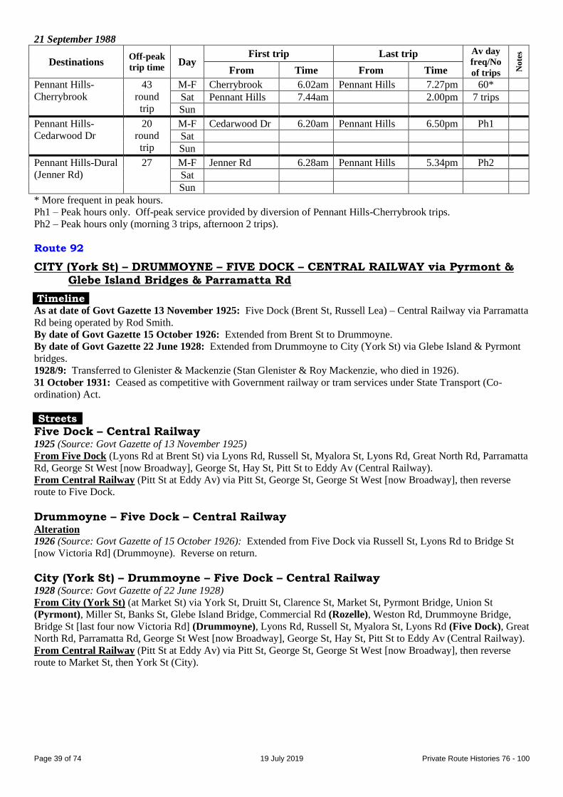
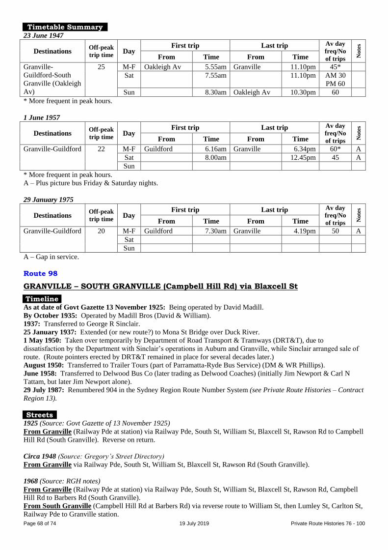
Timetable Summary September 1925
Destinations Off-peak
trip time Day
First trip Last trip Av day
freq/No
of trips No
tes
From Time From Time
Dover Rd, Rose
Bay-North Bondi
15 M-F Dover Rd 7.45am Nth Bondi 7.30pm 30
Sat 7.45am 10.30pm 30
Sun 7.45am 10.00pm 30
Page 2
Page 2 of 74 19 July 2019 Private Route Histories 76 - 100
Route 76
FAIRFIELD – FAIRFIELD WEST – ST JOHNS PARK – GREENFIELD PARK via Hamilton Rd
FAIRFIELD – WAKELEY (Avoca Rd) via Thorney Rd
(Parts of Fairfield West & St Johns Park on the western side of Smithfield Rd became the suburb of Greenfield Park in 1979.)
Timeline 1930s: Fairfield – Fairfield West (location?) via Hamilton Rd commenced by Cyril P Fisher (later operated by Mrs EJ
Fisher), later trading as Fishers Bus Service.
By 1946: Outer terminus was at Mimosa Rd, St Johns Park [in current Greenfield Park].
By August 1961: Most trips ran Fairfield – Fairfield West (King Rd), but selected trips extended to Greenfield
Rd/Mimosa Rd, St Johns Park. By 1983, most trips ran Fairfield – Richards Rd [in current Wakeley], but selected
trips extended to Greenfield Park. By September 1988, all trips had been extended to Greenfield Park (Sweethaven
Rd).
March 1963: Transferred to Calabro Bros.
By 23 May 1966: Extra route, Fairfield – Wakeley (Avoca Rd) via Thorney Rd, commenced.
8 June 1989: Transferred to Westbus (Bosnjak family, proprietors; Roger L Graham, general manager till 1990).
4 February 1991: Renumbered into the Sydney Region Route Number System (see Private Route Histories –
Contract Region 3):
824 Fairfield – Wakeley (Avoca Rd) via Thorney Rd
825 Fairfield – Greenfield Park via Hamilton Rd
Streets
Fairfield – Fairfield West (Mimosa Rd) Circa 1946 (Source: Gregory’s Street Directory)
From Fairfield (station) via The Crescent, Hamilton Rd [part now Dunstan St], Liverpool [now part of Smithfield]
Rd, Smithfield Rd, Mimosa Rd (Fairfield West) [in current Greenfield Park].
Alterations
Circa 1969 (Source: RGH notes/timetable): Outer terminus at Mimosa Rd/Greenfield Rd.
Circa 1984 (Source: timetable): From Smithfield Rd via Myrtle Rd, Greenfield Rd, Mimosa Rd, Smithfield
Rd, Richards Rd, Bulls Rd, Hamilton Rd.
Fairfield – Greenfield Park (Sweethaven Rd) Alteration
Circa 1988 (Source: timetable): Extended from Greenfield Park (Greenfield Rd) via Mimosa Rd, Powhatan St,
Arrowhead Rd, Sweethaven Rd, Cheyenne Rd, Cherokee Av, Smithfield Rd.
Fairfield – Wakeley (Avoca Rd) Circa 1969 (Source: RGH notes)
From Fairfield (The Crescent at station) via The Crescent, Hamilton Rd, The Boulevarde, Kalora Av, Maud St,
Thorney Rd, King Rd to Avoca Rd/Humphries Rd (Wakeley). Reverse on return.
Alteration
Circa 1984 (Source: timetable): Extended in Wakeley from King Rd/Avoca Rd via Avoca Rd, Foxlow St,
Wyharborough Pl, Harden St, Avoca Rd to King Rd.
Page 3
Page 3 of 74 19 July 2019 Private Route Histories 76 - 100
Timetable Summary 14 August 1961
Destinations Off-peak
trip time Day
First trip Last trip Av day
freq/No
of trips No
tes
From Time From Time
Fairfield-Fairfield
West (King Rd)†
Fr Fair
10K
14B
21G
M-F Mimosa Rd 5.22amF Greenfield Rd 6.34pmF A
Greenfield Rd 7.02amF Fairfield 9.41pmK
Sat Maude St 6.15amF 7.41pmK C
Fairfield 8.49amG Greenfield Rd 6.40pmF
Sun King Rd 7.42amF Box Rd 7.36pmF D
Fairfield 7.48amB Maude St 8.20pmF
* More frequent in peak hours.
† Selected trips extended to St Johns Park (Greenfield Rd).
A – Peak hours & day, Fairfield-Fairfield West (King Rd) 30*. 15 trips extended to Fairfield West (Maude St). 11
trips further extended to St Johns Park (Mimosa Rd or Greenfield Rd). Extra trips Friday night.
B – To Fairfield West (Box Rd).
C – Morning, Fairfield-Maude St 10-15. Afternoon, Fairfield-King Rd 30. 9 trips extended to St Johns Park (Mimosa
Rd or Greenfield Rd). Plus picture bus & trip from Fairfield to King Rd at 12.13am.
D – Day, Fairfield-King Rd 30. 3 trips extended to Box Rd. Gap in service.
F – To Fairfield.
G – To St Johns Park (Greenfield Rd).
K – To Fairfield West (King Rd).
30 November 1964
Destinations Off-peak
trip time Day
First trip Last trip Av day
freq/No
of trips No
tes
From Time From Time
Fairfield-Fairfield
West (King Rd)†
Fr Fair
10K
21S
M-F King Rd 5.13amF Fairfield 11.12pmK 30* A
Sat 5.38amF 11.12pmK AM 15
PM 30
A
Sun 7.48amF 7.14pmK 30 A
Fairfield-Wakeley
(Avoca Rd)
DATED 1966
12 M-F Avoca Rd 5.08am Fairfield 7.48pm 30
Sat 5.34am 11.52am 30
Sun
* More frequent in peak hours.
† Selected trips extended to St Johns Park.
A – Base service, Fairfield-Fairfield West (King Rd). Trips extended from Fairfield West (King Rd) to St Johns Park
(Mimosa Rd or Greenfield Rd): M-F 13, Saturday (6 from Greenfield Rd, 8 from Fairfield), Sunday 2. Many
short-workings ran Fairfield-Fairfield West (Maude St). Gap in service on Sunday.
F – To Fairfield.
K – To Fairfield West (King Rd).
S – To St Johns Park (Greenfield Rd).
1983
Destinations Off-peak
trip time Day
First trip Last trip Av day
freq/No
of trips No
tes
From Time From Time
Fairfield-Greenfield
Park
15 M-F Richards Rd 5.06am Fairfield 10.05pm 20* A
Sat 5.34am 6.07pm AM 15
PM 30
A
Sun Greenfield Pk 8.58am 5.36pm 30 B
* More frequent in peak hours.
A – Approx every third trip extended to Mimosa Rd or Greenfield Rd.
B – Gap in service.
Page 4
Page 4 of 74 19 July 2019 Private Route Histories 76 - 100
12 September 1988
Destinations Off-peak
trip time Day
First trip Last trip Av day
freq/No
of trips No
tes
From Time From Time
Fairfield-Greenfield
Park
24 M-F Greenfield Pk 4.28am Fairfield 10.25pm 20*
Sat 5.25am 6.50pm 30
Sun 8.18am 6.15pm 30 A
* More frequent in peak hours.
A – Gap in service.
Route 77
FIVE DOCK – DRUMMOYNE – CENTRAL RAILWAY via Glebe Island Bridge
Timeline As at date of Govt Gazette 13 November 1925: Thompson St/Rawson Av, Drummoyne – Central Railway being
operated by WH Bourne/Bourne & Co. Rod Smith may have also operated this route at some stage.
By date of Govt Gazette 22 June 1928: Extended from Thompson St/Rawson Av, Drummoyne to Brent St, Five
Dock.
About 1930: Transferred to Glenister & Mackenzie (Stan Glenister & Roy Mackenzie, who died in 1926)
31 October 1931: Ceased as competitive with Government railway or tram services under State Transport (Co-
ordination) Act.
Streets
Drummoyne – Central Railway 1925 (Source: Govt Gazette of 13 November 1925)
From Drummoyne (Thompson St at Rawson Av) via Thompson St, Lyons Rd, Bridge St, Drummoyne Bridge,
Weston Rd, Commercial Rd [all since Bridge St now Victoria Rd] (Rozelle), Glebe Island Bridge, Bank St, Miller St
(Pyrmont), Harris St, George St, Quay St to Bijou Lane (Central Railway).
From Central Railway (Quay St at Bijou Lane) via Quay St, Ultimo Rd, Harris St, then reverse route to Bridge St,
then Day St, Tranmere St, Rawson Av, Thompson St to Rawson Av (Drummoyne).
Five Dock – Drummoyne – Central Railway Alteration
1928 (Source: Govt Gazette of 22 June 1928): Extended to start from Five Dock (Brent St at Lyons Rd) [now located
in Russell Lea] via Brent St, Lyons Rd, Thompson St, Rawson Av, Tranmere St, Day St, Bridge St. Reverse on
return.
Timetable Summary September 1925
Destinations Off-peak
trip time Day
First trip Last trip Av day
freq/No
of trips No
tes
From Time From Time
Drummoyne-
Central Railway
25 M-F Drummoyne 6.40am Central Rly 11.00pm 30
Sat 6.40am 11.00pm 30
Sun 9.00am 11.15pm 30**
** Every 15 after 6.00pm Sundays.
Route 77
FAIRFIELD (station) – FAIRFIELD (? location)
Timeline By October 1935: Commenced by HG Delaney.
(?): Ceased or extended or revived as per following entry (?).
Route 77
FAIRFIELD – CABRAMATTA via Sackville St
General note: Fairfield – Fairfield South operated as part of 80 for a short period in 1936.
Timeline
Page 5
Page 5 of 74 19 July 2019 Private Route Histories 76 - 100
May 1946: Commenced by HJ Finch.
By 1 February 1949: Transferred to WA (Bill) & JC (Cec) Johnston.
May 1957: Transferred to Calabro Bros.
8 June 1989: Transferred to Westbus (Bosnjak family, proprietors; Roger L Graham, general manager till 1990).
4 February 1991: Absorbed into 830 (already in the Sydney Region Route Number System (see Private Route
Histories – Contract Region 3), which was rerouted via Sackville St between Fairfield and Cabramatta.
Streets Circa 1969 (Source: RGH notes)
From Fairfield (The Crescent at station) via Hamilton Rd, Lackey St, Frederick St, Hampton St, Avisford St,
Sackville St, St Johns Rd, Gladstone St, Hughes St, Railway Pde to Cabramatta station.
From Cabramatta (Railway Pde at station) via Railway Pde, John St, Hill St, Hughes St, then reverse route to
Hamilton Rd, then Barbara St, Harris St, Ware St to Fairfield station.
Timetable Summary 1 February 1949
Destinations Off-peak
trip time Day
First trip Last trip Av day
freq/No
of trips No
tes
From Time From Time
Fairfield-
Cabramatta
20 M-F Fairfield 5.50am Cabramatta 9.52pm 17 trips A
Sat 8.05am 6.40pm 12 trips A
Sun 8.05am 7.20pm 4 trips B
A – Selected trips ran Fairfield-Delamere St. Plus short-working/s before first trip shown. Plus picture bus
Wednesday, Friday & Saturday nights.
B – Selected trips ran Fairfield-Delamere St. Plus short-working/s after last trip shown.
26 September 1983
Destinations Off-peak
trip time Day
First trip Last trip Av day
freq/No
of trips No
tes
From Time From Time
Fairfield-
Cabramatta
20 M-F Cabramatta 6.14am Fairfield 6.10pm 20
Sat 7.45am 1.05pm 40
Sun
Route 78
FIVE DOCK (First Av) – DRUMMOYNE – CITY (York St) via Glebe Island & Pyrmont Bridges
Timeline As at date of Govt Gazette 13 November 1925: Drummoyne – City (York St) being operated by WH
Bourne/Bourne & Co.
By date of Govt Gazette 15 October 1926: Extended from Drummoyne to Five Dock (First Av)
By date of Govt Gazette 22 February 1929: Ceased.
Streets
Drummoyne – City (York St) 1925 (Source: Govt Gazette of 13 November 1925)
From Drummoyne (Bridge St [now Victoria Rd] at Lyons Rd) via Bridge St, Drummoyne Bridge, Weston Rd,
Commercial Rd [all since Bridge St now Victoria Rd] (Rozelle), Glebe Island Bridge, Bank St, Miller St (Pyrmont),
Union St, Pyrmont Bridge, Market St, York St to near Market St (City).
From City (York St) (at Market St) via York St, Druitt St, Clarence St, Market St, then reverse route to Drummoyne.
Five Dock (First Av) – Drummoyne – City (York St) Alteration
1926 (Source: Govt Gazette of 15 October 1926): Extended from Drummoyne via Lyons Rd, Great North Rd to
Bridge St (Five Dock). Reverse on return.
Page 6
Page 6 of 74 19 July 2019 Private Route Histories 76 - 100
Timetable Summary September 1925
Destinations Off-peak
trip time Day
First trip Last trip Av day
freq/No
of trips No
tes
From Time From Time
Drummoyne-City
(York St)
24 M-F Drummoyne 6.55am York St 6.10pm 30
Sat 6.55am 1.10pm 30
Sun
Route 78
FAIRFIELD – BOSSLEY PARK
Including King Rd (later Corio Rd) Loop
Timeline Between 1929 & 1932: Became a metropolitan bus route, after having been a “country” route. Operated by ME &
AR Evans (Muriel & Arthur Evans; Mrs Evans was a daughter of WH Willcox).
By 1960s:
Trading as Evans Bus Service.
Most trips ran Fairfield – King Rd (or via King Rd loop), but selected trips extended to Bossley Park.
1965: Transferred to Mrs Evans on the death of Mr Evans.
18 November 1976: Transferred to Bosnjaks Bus Service (Bosnjak family).
25 October 1982: Renumbered 832 in the Sydney Region Route Number System (see Private Route Histories –
Contract Region 3).
Streets
Fairfield – Bossley Park Circa 1946 (Source: Gregory’s Street Directory)
From Fairfield (station) via The Crescent, Ware St, Station St, The Boulevarde, Polding St, Mimosa Rd (Bossley
Park).
Alteration
Circa 1969 (Source: RGH notes): Extended in a loop from Mimosa Rd via Bossley Rd, Cowpasture Rd (Bossley
Park), Prairie Vale Rd, Mimosa Rd, back to Fairfield station.
Fairfield – Bossley Park (including King Rd (later Corio Rd) Loop) King Rd loop:
Mornings From Polding St via Liverpool [now Smithfield] Rd, King Rd to Polding St.
Afternoons From Polding St via King Rd, Liverpool [now Smithfield] Rd to Polding St.
Alterations
By October 1980 (Source: timetable):
From Fairfield via Smart St, Nelson St, Station St. Reverse on return.
(King Rd loop extended as Corio Rd loop): From Smithfield Rd via Beavors Rd, Corio Rd, Polding St.
(Selected trips): From Polding St via Prairie Vale Rd, Mimosa Rd, Polding St back to Fairfield station.
(Selected trips): Via Sackville St instead of The Boulevarde.
Timetable Summary 31 October 1966
Destinations Off-peak
trip time Day
First trip Last trip Av day
freq/No
of trips No
tes
From Time From Time
Fairfield-Bossley
Park
19 M-F King Rd 5.27am Fairfield 8.45pm 30* A
Sat 5.38am 7.15pm 15-30 A
Sun 8.25am 6.42pm 30-60 B
* More frequent in peak hours.
A – Trips extended to Bossley Park: M-F 21, Saturday 9.
B – 6 trips extended to Bossley Park. Gap in service.
Page 7
Page 7 of 74 19 July 2019 Private Route Histories 76 - 100
1978
Destinations Off-peak
trip time Day
First trip Last trip Av day
freq/No
of trips No
tes
From Time From Time
Fairfield-Bossley
Park
23 M-F Corio Rd 6.20am Fairfield 9.34pm 20* A
Sat 5.56pm 6.55pm AM 20
PM 30
A
Sun 8.48am 6.10pm 30 B
* More frequent in peak hours.
A – Trips extended to Bossley Park: M-F 17, Saturday 9.
B – 3 trips extended to Bossley Park. Gap in service.
Route 79
DRUMMOYNE – FIVE DOCK – BURWOOD via Lyons Rd
Timeline As at date of Govt Gazette 13 November 1925: Being operated by WH Bourne/Bourne & Co.
By date of Govt Gazette 15 October 1926: Ceased.
Streets 1925 (Source: Govt Gazette of 13 November 1925)
From Drummoyne (Lyons Rd at Bridge St [now Victoria Rd]) via Lyons Rd, Great North Rd (Five Dock),
Parramatta Rd, Burwood Rd, George St, Mary St, Deane St to Burwood Rd (Burwood).
From Burwood (Deane St at Burwood Rd) via Deane St, Burwood Rd, then reverse route to Drummoyne.
Timetable Summary September 1925
Destinations Off-peak
trip time Day
First trip Last trip Av day
freq/No
of trips No
tes
From Time From Time
Drummoyne-
Burwood
26 M-F Drummoyne 6.25amB
6.30amF
Burwood 7.46pmD A
Five Dock 10.50pmD
Sat 6.25amB
6.30amF
Burwood 7.46pmD A
Five Dock 10.50pmD
Sun 9.05amB Burwood 10.30pmD 60
A – Drummoyne-Five Dock 20, Drummoyne-Burwood 60.
B – To Burwood.
D – To Drummoyne.
F – To Five Dock.
Route 79
EASTWOOD – MARSFIELD (Waterloo Rd) via Vimiera Rd
Timeline By date of Govt Gazette 22 June 1928: Commenced.
By October 1935: Operated by Francis Myers.
By the late 1930s: Absorbed into 85.
Streets 1928 (Source: Govt Gazette of 22 June 1928)
From Eastwood (Railway Pde at station) via Railway Pde, Ethel St, Bennett [now Blaxland] Rd, Vimiera Rd to
Waterloo Rd (Marsfield). Reverse on return.
Page 8
Page 8 of 74 19 July 2019 Private Route Histories 76 - 100
Route 79
CITY (various termini) – TAMARAMA
Timeline 22 March 1948:
City (Macquarie Pl) – Tamarama commenced jointly by Roy A Berglund & JH (Joe) Bowden, who originally
owned one bus each.
Referred to originally as a “taxi–bus service.”
Soon after: City terminus altered from Macquarie Pl to opposite Sydney Town Hall (George St).
September 1953: Bowden assumed full control, then or later trading as Bowden’s Blue Express Bus Service and later
Bowden’s Express Bus Service.
5 June 1974: Transferred to Public Transport Commission when Bowden handed in license, due to declining
patronage on a route surrounded by Government bus routes.
Streets
City (Macquarie Pl) – Tamarama Circa 1948 (Source: Gregory’s Street Directory)
From Tamarama via Fletcher St, Alexander St, Kenneth St, Gaerloch Av, Pacific Av, Marine Dr [now Tamarama
Marine Dr & Bronte Marine Dr] (Bronte), Bayview St, Hewlett St, Alfred St, Birrell St (Waverley), York Rd, Oxford
St, Moore Park Rd, Fitzroy St, Crown St, Oxford St, College St, Prince Albert Rd, Macquarie St, Bridge St,
Macquarie Pl (City).
City (Town Hall) – Tamarama Circa 1965 (Source: RGH notes)
From City (Town Hall) (George St) via Bathurst St, Elizabeth St, Liverpool St, Oxford St, Flinders St, Moore Park
Rd, Oxford St, York Rd, Birrell St (Waverley), Ashton St, York Rd, Queens Park Rd (Queens Park), Bourke St,
Birrell St, Bronte Rd, Murray St, Hewlett St (Bronte), (second) Bayview St, Bronte Marine Dr, Tamarama Marine Dr,
Pacific Av, Gaerloch Av, Kenneth St, Marks Lane, Fletcher St to Alexander St (Tamarama).
From Tamarama (Fletcher St at Alexander St) via Alexander St, Gaerloch Av, then reverse route to Elizabeth St,
then Park St, George St to opposite Town Hall (City).
Alteration
Circa 1970 (Source: RGH notes): Ex City (Town Hall) from Bourke St via Birrell St, Carrington Rd, Victoria St,
Prospect St, Bronte Rd. Reverse on return.
Timetable Summary 22 March 1962
Destinations Off-peak
trip time Day
First trip Last trip Av day
freq/No
of trips No
tes
From Time From Time
City (Town Hall)-
Tamarama
30 M-F Tamarama 6.15am Town Hall 11.05pm 30*
Sat 7.00am 11.05pm 30
Sun
* More frequent in peak hours.
Route 80
DRUMMOYNE – FIVE DOCK – STRATHFIELD via Lyons Rd
Timeline As at date of Govt Gazette 13 November 1925: In operation.
By date of Govt Gazette 15 October 1926: Ceased.
Streets 1925 (Source: Govt Gazette of 13 November 1925)
From Drummoyne (Lyons Rd at Bridge St [now Victoria Rd]) via Lyons Rd, Great North Rd (Five Dock),
Parramatta Rd, Moseley St, Everton Rd to Bridge Rd [which passed over railway station] (Strathfield station).
Reverse on return.
Page 9
Page 9 of 74 19 July 2019 Private Route Histories 76 - 100
Timetable Summary September 1925
Destinations Off-peak
trip time Day
First trip Last trip Av day
freq/No
of trips No
tes
From Time From Time
Drummoyne-
Strathfield
28 M-F Drummoyne 6.45amF
8.05amS
Strathfield 6.15pmD 60 A
Five Dock 10.50pmD
Sat Drummoyne 6.45amF
8.05amS
Strathfield 6.15pmD 60 A
Five Dock 10.50pmD
Sun Drummoyne 1.30pmS Strathfield 10.00pmD 60
A – Day, Drummoyne-Strathfield (& short-working/s in peak hours). Night, Drummoyne-Five Dock.
D – To Drummoyne.
F – To Five Dock.
S – To Strathfield.
Route 80
FAIRFIELD – WETHERILL PARK via various routes
Extended from Fairfield to Fairfield South (1936)
Extended from Wetherill Park to Horsley Park (limited service, from 1933)
Further extended from Horsley Park Post Office to Horsley Park Loop
Fairfield – Smithfield (Chifley St) (1976-82)
(Smithfield St between Fairfield & Wetherill Park is now The Horsley Dr.)
Timeline 1925: Fairfield – Wetherill Park via Smithfield St commenced by CW Gordon.
1928: Transferred to SF (Sam) Money. (A list dated October 1935 shows operator as Mrs MT Money.)
17 August 1933: Selected trips extended from Wetherill Park to Horsley Park Post Office.
14 September 1936: Extended from Fairfield to Fairfield South (Delamere & Sackville Sts).
24 October 1936: Extension from Fairfield to Fairfield South ceased. A similar but extended route, Fairfield –
Cabramatta via Sackville St, operated as 77 as from May 1946.
September 1947: Transferred to JC (Cec) Johnston.
By March 1950:
Transferred to WA (Bill) & JC (Cec) Johnston.
Trips between Fairfield & Smithfield ran either via Smithfield St or via Brenan St.
October 1962: Operator incorporated as Smithfield Transport.
By 1965: Selected trips extended beyond Horsley Park Post Office to Horsley Park Loop (some timetables referred to
“first” & “second” loops [streets?]).
13 March 1965: Transferred to Fairlines Bus Service (Treuer family).
By January 1976: Extra route, Fairfield – Smithfield (Chifley St) (industrial area), commenced.
Early November 1976: Transferred to Bosnjaks Bus Service.
11 September 1978: Extra route, Fairfield – Wetherill Park via Brenan & Shakespeare Sts, commenced.
By May 1979: Fairfield – Wetherill Park via Brenan & Shakespeare Sts incorporated into other Fairfield – Wetherill
Park routes (via The Horsley Dr or via Brenan St). Most Wetherill Park trips ran from Fairfield via one route &
returned via the other.
25 October 1982: Renumbered in to the Sydney Region Route Number System (see Private Route Histories –
Contract Region 3):
828 Fairfield – Wetherill Park via The Horsley Dr (& limited service extended to Horsley Park Post Office or
Horsley Park Loop)
829 Fairfield – Wetherill Park via Brenan & Shakespeare Sts (selected trips via Chifley St).
Streets
Fairfield – Wetherill Park (selected trips extended to Horsley Park) Circa 1946 (Source: Gregory’s Street Directory)
From Fairfield (The Crescent at station) via The Crescent, Ware St, Nelson St, Smithfield St (Smithfield), Wetherill
St, Daniel St [now The Horsley Dr], Whinstanes Rd [now Daniel St], Park St [now Daniel St] (Wetherill Park).
Horsley Park extension (likely route): From Wetherill Park via Whinstanes Rd [now The Horsley Dr], Cowpasture
Rd, Horsley Rd to Horsley Park Post Office. Reverse on return.
Page 10
Page 10 of 74 19 July 2019 Private Route Histories 76 - 100
Fairfield – Wetherill Park via The Horsley Dr (selected trips extended to Horsley Park) Circa 1969 (Source: RGH notes)
From Fairfield (The Crescent at station) via The Crescent, Ware St, Nelson St, The Horsley Dr (Smithfield) to
Wetherill St (Wetherill Park).
From Wetherill Park (The Horsley Dr at Wetherill St) via The Horsley Dr, Smithfield St [now Court Rd], The
Crescent to Fairfield station.
Horsley Park extension: From Wetherill Park (The Horsley Dr at Wetherill St) via The Horsley Dr to Horsley Park
Post Office. Reverse on return.
Fairfield – Wetherill Park via Brenan St (selected trips extended to Horsley Park) Circa 1969 (Source: RGH notes)
From Fairfield (The Crescent at station) via The Crescent, Ware St, Nelson St, The Horsley Dr, Brenan St, Liverpool
[now Smithfield] Rd, The Horsley Dr (Smithfield) to Wetherill St (Wetherill Park).
From Wetherill Park (The Horsley Dr at Wetherill St) via reverse route to Brenan St, then The Horsley Dr,
Smithfield St [now Court Rd], The Crescent to Fairfield station.
Horsley Park extension: From Wetherill Park (The Horsley Dr at Wetherill St) via The Horsley Dr to Horsley Park
Post Office. Reverse on return.
Horsley Park Loop 1965 (Source: timetable)
From Horsley Park (Post Office) via Arundel Rd, [Chandos [now Burley] Rd,] Delaware Rd, Horsley Rd to Horsley
Park Post Office.
Circa 1969 (Source: RGH notes/timetable)
From Horsley Park (Post Office) via Arundel Rd, Chandos [now Burley] Rd, Delaware Rd, Horsley Rd, Garfield Rd,
Lincoln Rd, Horsley Rd to Horsley Park Post Office.
Fairfield – Wetherill Park via The Horsley Dr & return via Brenan St 1979 (Source: timetable)
From Fairfield (The Crescent at station) via The Crescent, Smart St, Nelson St, The Horsley Dr (Smithfield),
Elizabeth St [now Herrick St] (Wetherill Park), Shakespeare St [beyond Lily St, approx along current Vidal St &
Newmen Cl], Wetherill St, Brenan St, The Horsley Dr, Court Rd, The Crescent to Fairfield station.
Fairfield – Wetherill Park via Brenan St & return via The Horsley Dr 1979 (Source: timetable)
From Fairfield (The Crescent at station) via The Crescent, Smart St, Nelson St, The Horsley Dr, Brenan St
(Smithfield), Wetherill St, Shakespeare St [beyond Lily St, approx along current Vidal St & Newmen Cl], Elizabeth
St [now Herrick St] (Wetherill Park), The Horsley Dr, Court Rd, The Crescent to Fairfield station.
Fairfield – Smithfield (Chifley St) 1979 (Source: timetable/UBD Compact street directory)
From Fairfield (The Crescent at station) via The Crescent, Ware St, Nelson St, The Horsley Dr (Smithfield),
O’Connell St, Chifley St, Dublin St, Rosford St, Eyre St, Hassall St, Victoria St, Wetherill St to The Horsley Dr.
Reverse on return.
Trips via Brenan St: Via Brenan St & Liverpool [now Smithfield] Rd.
Page 11
Page 11 of 74 19 July 2019 Private Route Histories 76 - 100
Timetable Summary 13 March 1950
Destinations Off-peak
trip time Day
First trip Last trip Av day
freq/No
of trips No
tes
From Time From Time
Fairfield-Wetherill
Park (Wetherill
St)†
Fr Fair
20W
25H
M-F Horsley Pk 5.27amF Fairfield 6.25pmH
9.45pmW
A
Sat Wetherill St 6.00amF 11.12pmH
12.30amW
B
Fairfield 7.12amH
Sun Horsley Pk 7.15amF 6.45pmH
10.25pmW
C
† Via either Smithfield St or via Brenan St. Selected trips extended to Horsley Park.
A – Fairfield-Wetherill Park (Wetherill St) 45-60 (21 trips via Smithfield St, 16 trips via Brenan St). 14 trips extended
to Wetherill Park (Daniel St), 7 trips further extended to Horsley Park.
B – Fairfield-Wetherill Park (Wetherill St) 19 trips (15 trips via Smithfield St, 4 trips via Brenan St), plus short-
workings Fairfield-Smithfield. 7 trips extended to Wetherill Park (Daniel St), 5 trips further extended to
Horsley Park.
C – Fairfield-Wetherill Park (Wetherill St) 60 (8 trips via Smithfield St, 4 trips via Brenan St). Gap in service. 5 trips
extended to Wetherill Park (Daniel St), 3 trips further extended to Horsley Park.
F – To Fairfield.
H – To Horsley Park.
W – To Wetherill Park (Wetherill St).
5 May 1968
Destinations Off-peak
trip time Day
First trip Last trip Av day
freq/No
of trips No
tes
From Time From Time
Fairfield-Wetherill
Park (Wetherill
St)†
Fr Fair
20W
25H
M-F Wetherill St 5.04amF Horsley Pk 7.38pmF A
Horsley Pk 5.18amF Fairfield 9.45pmW
Sat Wetherill St 5.04amF Horsley Pk 6.55pmF B
Horsley Pk 5.45amF Fairfield 7.40pmW
Sun Wetherill St 7.20amF Horsley Pk 6.37pmF C
Horsley Pk 9.37amF Fairfield 7.40pmW
* More frequent in peak hours.
† Via either The Horsley Dr or via Brenan St. Selected trips extended to Horsley Park & Cecil Park.
A – Day & night, Fairfield-Wetherill Park (Wetherill St) 15*. Generally alternate trips via The Horsley Dr & via
Brenan St. 14 trips extended to Horsley Park. Selected trips on weekdays further extended to Horsley Park
Loop.
B – Day, Fairfield-Wetherill Park (Wetherill St): morning 15, afternoon 30. Generally alternate trips via The Horsley
Dr & via Brenan St. 8 trips extended to Horsley Park.
C – Day, Fairfield-Wetherill Park (Wetherill St) 30. Generally alternate trips via The Horsley Dr & via Brenan St. 2
trips extended to Horsley Park.
F – To Fairfield.
H – To Horsley Park.
W – To Wetherill Park (Wetherill St).
Route 81
CITY (York St) – DRUMMOYNE – FIVE DOCK – CENTRAL RAILWAY via Pyrmont &
Glebe Island Bridges, Lyons & Parramatta Rds
Timeline As at date of Govt Gazette 13 November 1925: Drummoyne – Five Dock – Central Railway via Lyons &
Parramatta Rds being operated by Rod Smith in conjunction with 92. Brien & Brien also operated this route at some
stage.
By date of Govt Gazette 22 June 1928: Extended from Drummoyne to City (York St) via Glebe Island & Pyrmont
Bridges, making it an almost circular route.
1929/30: Transferred to Glenister & Mackenzie (Stan Glenister & Roy Mackenzie, who died in 1926).
31 October 1931: Ceased as competitive with Government railway or tram services under State Transport (Co-
ordination) Act.
Page 12
Page 12 of 74 19 July 2019 Private Route Histories 76 - 100
Streets
Drummoyne – Five Dock – Central Railway 1925 (Source: Govt Gazette of 13 November 1925)
From Drummoyne (Lyons Rd at Bridge St [now Victoria Rd]) via Lyons Rd, Great North Rd (Five Dock),
Parramatta Rd, George St West [now Broadway], George St, Hay St, Pitt St to Eddy Av (Central Railway).
From Central Railway (Pitt St at Eddy Av) via Pitt St, George St, George St West [now Broadway], then reverse
route to Drummoyne.
City (York St) – Drummoyne – Five Dock – Central Railway 1928 (Source: Govt Gazette of 22 June 1928)
From City (York St) (at Market St) via York St, Druitt St, Clarence St, Market St, Pyrmont Bridge, Union St
(Pyrmont), Miller St, Bank St, Glebe Island Bridge, Commercial Rd, Weston Rd (Rozelle), Bridge St [all since Glebe
Island Bridge now Victoria Rd] (Drummoyne), Lyons Rd, Great North Rd (Five Dock), Parramatta Rd, George St
West [now Broadway], George St, Hay St, Pitt St to Eddy Av (Central Railway).
From Central Railway (Pitt St at Eddy Av) via Pitt St, George St, George St West [now Broadway], then reverse
route to Pyrmont Bridge, then Market St, York St to near Market St (City).
Timetable Summary September 1925
Destinations Off-peak
trip time Day
First trip Last trip Av day
freq/No
of trips No
tes
From Time From Time
Drummoyne-
Central Railway
45 M-F Central Rly 7.02am Drummoyne 7.53pm 90 A
Sat 7.02am 7.53pm 90 A
Sun
A – Extra trips Friday & Saturday nights.
Route 81
FAIRFIELD – LANSVALE – CABRAMATTA
Trips via Hollywood [picnic grounds], Lansvale (circa 1950s)
(Hollywood picnic grounds were on site of current Liverpool Golf Club, at the end of
Hollywood Dr, Lansvale.)
Timeline 3 October 1936: Fairfield – Lansvale – Cabramatta commenced by GW Stanton.
February 1945: Transferred to Booty & Tibbles.
October 1945: Transferred to LA Tibbles.
About 1947: Transferred to CA Booty.
1949:
Transferred to JH Moore.
About this time, selected trips on Sundays & Public Holidays service ran via “Hollywood” (ceased by mid-
1950s).
October 1952: Transferred to JC Hatcher. (An undated timetable for Route 81 while JC Hatcher was proprietor –
1952 to 1955 – shows a peak hour service, Fairfield – Villawood, which later became 83.)
October 1955: Transferred to Scott & Fletcher.
November 1955: Transferred to John A Gilbert on a temporary basis until transfer to a more permanent operator
could be arranged.
February 1956: Transferred to partnership of SC (Syd) Katen & AJ (Alf) Heath.
1 November 1995: Renumbered 817 in the Sydney Region Route Number System (see Private Route Histories –
Contract Region 13).
Streets Circa 1946 (Source: Gregory’s Street Directory)
From Fairfield via Dale St, Fairfield St, Crown St, Hanson St, Normanby St, Tangerine St, Carrington Rd [now The
Horsley Dr], Hume Hwy, Water Reserve Rd [now Knight St], Prospect Creek Rd [now Day St], Lansdowne [now
Willis] St (Lansvale), Georges Hall Rd [now Hollywood Dr], Prospect Creek Rd [now Day St], Georges Hall Rd
[now Hollywood Dr], Hume Hwy, Cabramatta Rd [East], Broomfield St (Cabramatta).
Page 13
Page 13 of 74 19 July 2019 Private Route Histories 76 - 100
Circa 1969 (Source: RGH notes)
From Fairfield (Dale St at station) via Dale St, Fairfield St, Crown St, Hanson St, Normanby St, Tangerine St, The
Horsley Dr, Hume Hwy, Knight St, Day St, Willis St (Lansvale), Hollywood Dr, Hume Hwy, Lansdowne Rd, Vale
St, Longfield St, Hume Hwy, Cabramatta Rd East, Broomfield St to Cabramatta station.
From Cabramatta (Broomfield St at station) via Fisher St, Cumberland St, Cabramatta Rd East, then reverse route to
Dale St, then Anzac Av, Lawson St, Wilga St, Dale St to Fairfield station.
Trips via Vine St: Ex Fairfield from Dale St via Vine St, Diprose St, The Horsley Dr. Return from The Horsley Dr
via Diprose St, Vine St, Lawson St, Wilga St, Dale St to Fairfield station.
Alterations
Circa 1986 (Source: RGH notes):
Ex Fairfield from Longfield St via Ralph St, Chadderton St, Hume Hwy. Reverse on return.
Via Gordon St instead of Diprose St.
Timetable Summary 12 September 1949
Destinations Off-peak
trip time Day
First trip Last trip Av day
freq/No
of trips No
tes
From Time From Time
Fairfield-
Cabramatta
29 M-F Fairfield 6.22pm Cabramatta 7.10pm 30-60 A
Sat 8.05am 7.00pm 30 A
Sun 9.15am 6.45pm 6 trips
A – Plus short-working/s before first trip shown. Plus picture bus to Fairfield Wednesday, Friday & Saturday nights.
Gap in service on Saturday.
1 March 1987
Destinations Off-peak
trip time Day
First trip Last trip Av day
freq/No
of trips No
tes
From Time From Time
Fairfield-
Cabramatta
26 M-F Fairfield 6.35am Cabramatta 7.15pm 60* A
Sat 8.40am 6.15pm 60 B
Sun Lansvale 7.30am Fairfield 10.55am 4 trips C
* More frequent in peak hours.
A – Plus short-working/s before first trip shown.
B – Gap in service.
C – 1 trip extended from Lansvale to Cabramatta.
Route 82
DUMBLETON – HURSTVILLE – SYDENHAM – CENTRAL RAILWAY via Forest Rd
(Dumbleton was renamed Beverly Hills in 1940.)
Timeline As at date of Govt Gazette 13 November 1925: Being operated by Blue Transit Co (Frank K Bardsley) (?).
By date of Govt Gazette 15 October 1926: Ceased.
Streets 1925 (Source: Govt Gazette of 13 November 1925)
From Dumbleton (Penshurst St at Stoney Creek Rd) via Penshurst St, Forest Rd (Hurstville), Rocky Point Rd, King
St [last two now Princes Hwy], Lymerston St, Unwins Bridge Rd, Marrickville [now Railway] Rd, Bolton St [part
now Burrows Av] (Sydenham), [railway bridge – then an extension of Sydenham Rd], Railway Pde, Marrickville Rd,
Victoria Rd, Juliet St, Llewellyn St, Alice St, King St (Newtown), Australia St, University St [now Salisbury Rd],
Missenden Rd, Parramatta Rd, George St West [now Broadway], George St, Hay St, Pitt St to Eddy Av (Central
Railway).
From Central Railway (Pitt St at Eddy Av) via Pitt St, George St, George St West [now Broadway], then reverse
route to Dumbleton.
Page 14
Page 14 of 74 19 July 2019 Private Route Histories 76 - 100
Timetable Summary September 1925
Destinations Off-peak
trip time Day
First trip Last trip Av day
freq/No
of trips No
tes
From Time From Time
Dumbleton-Central
Railway
71 M-F Dumbleton 6.20am Central Rly 10.30pm 45-90
Sat 6.20am 10.30pm 45-90
Sun 6.20am 10.30pm 45-90
Route 82
EPPING – CARLINGFORD via Ray Rd EPPING – EPPING (Malton Rd) [in current North Epping]
Timeline By date of Govt Gazette 22 June 1928: Epping – Carlingford (Pennant Pde) via Ray Rd commenced by E Miles.
By 30 June 1933: Extended in Carlingford from Ray Rd to Church St [now Marsden Rd]/Pennant Hills Rd.
12 March 1934:
Epping – North Epping (Malton Rd) section of 89 transferred from Cedric ME Troy & amalgamated with 82.
Curtailed from Church St [now Marsden Rd]/Pennant Hills Rd to Ray Rd/Pennant Pde.
After October 1935: Transferred to JE Sinclair & AJ (Archie) Moore.
April 1940: Transferred to RR Palme.
Late 1942: Re-transferred to JE Sinclair & AJ Moore.
December 1946: Transferred to Parramatta – Epping Bus Service (Moore family).
December 1947: Transferred to Richards Bros.
December 1951: Transferred to Watson & Hulme.
By 1952: Extended from Ray Rd/Pennant Pde to North Rocks Rd/Pennant Pde.
By 6 July 1959: Extended in Carlingford from North Rocks Rd/Pennant Pde to North Rocks Rd/Bengahzi Rd (by
1962 ran in a loop via Alamein Av, Bengahzi Rd & North Rocks Rd).
February 1961: Transferred to Ray Rd-Malton Rd Bus Service (partnership of WE (Bill) Hayward & EM (Eddie)
Hayman).
December 1962: Transferred to Epping Passenger Service (Bill Hayward).
March 1963: Transferred to Northern Districts Bus Lines (Col Sinclair & Carl N Tattam), also trading as Fleet
Services.
11 July 1963:
Epping – North Epping transferred to Carl Tattam and renumbered 163.
Remaining part of route, Epping – Carlingford, then fully owned by Col Sinclair, trading as Dundas Valley
Coach Co or Sinclair Transport Industries.
Late Saturday afternoon & Sunday service continued as combined 82/163 till at least 1969.
By 15 June 1965: Selected trips diverted via Rembrandt St (Village shopping centre, later Carlingford Court, later
Carlingford Square).
13 December 1973: Transferred to Harris Park Transport (Moore family).
13 January 1992: Most Saturday trips extended from Carlingford to North Rocks to cover 90.
4 November 1996: 82 & 90 reorganised and renumbered into the Sydney Region Route Number System (see Private
Route Histories – Routes transferred to State Transit Authority):
628 Epping – Carlingford
629 Epping – North Rocks.
Streets
Epping – Epping (Ray Rd) 1928 (Source: Govt Gazette of 22 June 1928)
From Epping (High St [now Beecroft Rd] at station) via High St, Carlingford Rd, Ray Rd to Pennant Pde. Reverse
on return.
Epping (Norfolk Rd) – Epping (station) – Epping (Ray Rd) Circa 1946 (Source: Gregory’s Street Directory)
From Norfolk Rd (at Malton Rd?) via Norfolk Rd, Oxford St, Langston Pl (Epping station), Bridge St, Beecroft Rd,
Carlingford Rd, Ray Rd.
Page 15
Page 15 of 74 19 July 2019 Private Route Histories 76 - 100
North Epping – Epping (station) – Carlingford Circa 1962 (Source: timetable)
From North Epping (Boundary Rd/Malton Rd) via Boundary Rd, Eastcote Rd, Malton Rd, Norfolk Rd, Oxford St,
Langston Pl (Epping), Epping Rd, Beecroft Rd, Kandy Av, Ray Rd, Pennant Pde, Alamein Av, Benghazi Rd
(Carlingford), North Rocks Rd, Pennant Pde, then reverse route to Malton Rd, then Boundary Rd (North Epping).
Epping – Carlingford (North Rocks Rd) Circa 1965 (Source: RGH notes)
From Epping (Beecroft Rd at station) via Carlingford Rd, Ray Rd, Pennant Pde, Alamein Av, Benghazi Rd
(Carlingford), North Rocks Rd, Pennant Pde, Ray Rd, Rawson Rd, Bridge St, Beecroft Rd to Epping station.
Epping – Carlingford (Rembrandt St) Circa 1965 (Source: RGH notes)
From Epping (Beecroft Rd at station) via Carlingford Rd, Ray Rd, Pennant Pde, McKechnie St, Eyles St, Anthony
St, Keats St, Milton St, Rembrandt St (Carlingford), Dunrossil Av, Pennant Pde, Ray Rd, Rawson Rd, Bridge St,
Beecroft Rd to Epping station.
Alterations
Circa 1975 (Source: timetable): From Carlingford Rd via Ray Rd, Pennant Pde, Dunrossil Av, Pennant Hills
Rd, Carlingford Rd, Rembrandt St (Carlingford), Milton St, Keats St, Anthony St, Eyles St, McKechnie St,
Pennant Pde, Ray Rd, Rawson Rd, Bridge St, Beecroft Rd to Epping station.
Circa 1983 (Source: timetable): Many trips ran via both Rembrandt St & North Rocks Rd loops, in either
order.
Timetable Summary
6 August 1956
Destinations Off-peak
trip time Day
First trip Last trip Av day
freq/No
of trips No
tes
From Time From Time
Epping-Carlingford
via Ray Rd
12 M-F Nth Rocks Rd 5.46am Epping 7.58pm 60* A
Sat 6.27am 7.21pm 7 trips A
Sun 6.25am 8.55pm 8 trips
Epping-North
Epping
9 M-F Epping 6.04am Nth Epping 7.45pm 60* A
Sat 6.45am 7.29pm 12 trips A
Sun 6.38am 8.44pm 8 trips
* More frequent in peak hours.
A – Plus picture bus Wednesday & Saturday nights.
September 1964
Destinations Off-peak
trip time Day
First trip Last trip Av day
freq/No
of trips No
tes
From Time From Time
Epping-Carlingford
via Ray Rd
26
round
trip
M-F Nth Rocks Rd 5.48am Epping 7.35pm 30*
Sat 7.10am 7.00pm 30 A
Sun 7.35am 11.46am 5 trips
* More frequent in peak hours.
A – Gap in service.
July 1984
Destinations Off-peak
trip time Day
First trip Last trip Av day
freq/No
of trips No
tes
From Time From Time
Epping-Carlingford
via Ray Rd
24
round
trip
M-F Nth Rocks Rd 5.45am Epping 7.32pm 30*
Sat 8.04am 1.05pm 30
Sun
* More frequent in peak hours.
Page 16
Page 16 of 74 19 July 2019 Private Route Histories 76 - 100
12 August 1996
Destinations Off-peak
trip time Day
First trip Last trip Av day
freq/No
of trips No
tes
From Time From Time
Epping-Carlingford
via Ray Rd
28
round
trip
M-F Nth Rocks Rd 5.43am Epping 9.50pm 30*
Sat 7.50am 7.00pm 60 A
Sun Epping 8.16am Epping 5.10pm 60
* More frequent in peak hours.
A – Combined with 90.
Route 83
DUMBLETON – HURSTVILLE – CENTRAL RAILWAY via Forest Rd
Post 31 October 1931 feeder: DUMBLETON – HURSTVILLE – NARWEE
(Dumbleton was renamed Beverly Hills in 1940.)
Timeline As at date of Govt Gazette 13 November 1925: Dumbleton – Central Railway being operated by Blue Transit Co
(Bardsley & Warburton families), which also traded as Bardsley’s Motor Saloons on this route.
By date of Govt Gazette 4 April 1930: Rerouted via Enmore & Salisbury Rd instead of Newtown.
31 October 1931: Ceased as competitive with Government railway or tram services under State Transport (Co-
ordination) Act.
1932(?): Relicensed as a feeder, Dumbleton – Hurstville, operated by Thornton E Harrigan.
Later in 1932: Transferred to Arthur Marrin (by 1940s trading as Red & White Bus Service).
1934: Extended from Dumbleton to Narwee.
1940s (after 1 March 1942): Suspended as service regarded as non-essential following introduction of petrol rationing
during World War II.
2 January 1944: Resumed as part of 28.
Streets
Dumbleton – Hurstville – Newtown – Central Railway 1925 (Source: Govt Gazette of 13 November 1925)
From Dumbleton (Penshurst St at Stoney Creek Rd) via Penshurst St, Forest Rd (Hurstville), Rocky Point Rd, King
St [last two now Princes Hwy] (Newtown), Australia St, Parramatta Rd, George St West [now Broadway], George St,
Hay St, Pitt St to Eddy Av (Central Railway).
From Central Railway (Pitt St at Eddy Av) via Pitt St, George St, George St West [now Broadway], then reverse
route to Dumbleton.
Dumbleton – Hurstville – Enmore – Central Railway Alteration
1930 (Source: Govt Gazette of 4 April 1930): Ex Dumbleton from King St via May St, Edgeware Rd, Stanmore Rd,
Liberty St, Railway Av, Cardigan St, Salisbury Rd (Camperdown), University St [now Salisbury Rd], Missenden Rd,
Parramatta Rd. Reverse on return.
Timetable Summary September 1925
Destinations Off-peak
trip time Day
First trip Last trip Av day
freq/No
of trips No
tes
From Time From Time
Dumbleton-Central
Railway
71 M-F Dumbleton 6.05am Central Rly 11.35pm 30
Sat 6.05am 11.35pm 30
Sun 7.35am 10.00pm 30
Page 17
Page 17 of 74 19 July 2019 Private Route Histories 76 - 100
1 March 1942
Destinations Off-peak
trip time Day
First trip Last trip Av day
freq/No
of trips No
tes
From Time From Time
Narwee-Hurstville 12 M-F Narwee 6.52am Hurstville 7.31pm 40
Sat 7.14am 11.51pm AM 30 PM 6 trips
A
Sun
A – Gaps in service. Plus picture bus.
Route 83
FAIRFIELD – VILLAWOOD – CHESTER HILL
Timeline July 1947: Fairfield – Villawood – Chester Hill (via Woodville Rd, Hume Hwy & Chester Hill Rd?) commenced by
LA Tibbles.
1948: Ceased.
April 1953: Revived as Villawood – Chester Hill (? route), operated by RJ Martin.
September 1953: Ceased.
Later: Recommenced as Fairfield – Villawood, operated by JC Hatcher. (An undated timetable for Route 81 while
JC Hatcher was proprietor – 1952 to 1955 – shows a peak hour service, Fairfield – Villawood.)
October 1955: Transferred to Scott & Fletcher.
November 1955: Transferred to John A Gilbert on a temporary basis until transfer to a more permanent operator
could be arranged.
February 1956: Transferred to partnership of SC (Syd) Katen & AJ (Alf) Heath.
By June 1958: Extended from Villawood to Chester Hill to become Fairfield – Villawood – Chester Hill (probably
via Normanby St, Alcoomie St & Miller Rd).
30 June 1958: New route, Fairfield – Villawood – Chester Hill via River Av, Belar Av & Chester Hill Rd,
commenced, making base routes:
Fairfield – Villawood – Chester Hill via Normanby St, Alcoomie St & Miller Rd
Fairfield – Villawood – Chester Hill via River Av, Belar Av & Chester Hill Rd
Selected trips ran via a combined route.
1 November 1995: Renumbered 818 in the Sydney Region Route Number System (see Private Route Histories –
Contract Region 13).
Streets
Fairfield – Villawood – Chester Hill Circa 1948 (Source: Gregory’s Street Directory)
From Fairfield (station) via Dale St, Vine [part now Bland] St, Mitchell St, Normanby St, Bligh St, Mandarin St,
Tangerine St, Woodville Rd (Villawood), Hume Hwy, Chester Hill Rd, Waldron Rd, Priam St, Leicester St, Bent St,
Waldron Rd (Chester Hill).
Fairfield – Villawood – Chester Hill via Normanby St, Alcoomie St & Miller Rd Circa 1969 (Source: RGH notes)
From Fairfield (Dale St at station) via Dale St, Vine St, Bland St, Mitchell St, Normanby St, Tangerine St, Woodville
Rd (Villawood), Binnaburra St, Belar Av, Alcoomie St, Nurragi St, Goonaroi St, Mundamatta St, Miller Rd, Sir
Thomas Mitchell Rd, Orchard Rd, Proctor Pde, Chester Hill Rd, Waldron Rd to Chester Hill station.
From Chester Hill (Waldron Rd at station) via Bent St, Leicester St, Priam St, Waldron Rd, then reverse route to
Vine St, then Wilga St, Dale St to Fairfield station.
Fairfield – Villawood – Chester Hill via River Av, Belar Av & Chester Hill Rd Circa 1969 (Source: RGH notes)
From Fairfield (Dale St at station) via Dale St, Vine St, Diprose St, The Horsley Dr, Mitchell St, Ruby St, River Av,
Mandarin St, Tangerine St, Woodville Rd (Villawood), Hume Hwy, Derribong St, Belar Av, Lowana St, Mundamatta
St, Miller Rd, Hume Hwy (Bass Hill), Chester Hill Rd, Waldron Rd to Chester Hill station.
From Chester Hill (Waldron Rd at station) via Bent St, Leicester St, Priam St, Waldron Rd, then reverse route to
Vine St, then Wilga St, Dale St to Fairfield station.
Page 18
Page 18 of 74 19 July 2019 Private Route Histories 76 - 100
Alterations
Circa 1986 (Source: RGH notes):
Ex Fairfield:
From River Av direct to Woodville Rd. Reverse on return.
Via Gordon St instead of Diprose St.
Fairfield – Villawood – Chester Hill via combined route Circa 1969 (Source: RGH notes)
From Fairfield via either of the above routes to Woodville Rd, then Hume Hwy, Derribong St, Alcoomie St,
Killanoola St, Lowana St, Camira St, Belar Av, Lowana St, Mundamatta St, Miller Rd, then either of the above routes
to Chester Hill. Reverse on return.
Alteration
Circa 1986 (Source: RGH notes) (Combined route): Ex Fairfield from Hume Hwy via Derribong St, Gundaroo St,
Carrawatha St, Alcoomie St. Reverse on return.
Timetable Summary 1 July 1966
Destinations Off-peak
trip time Day
First trip Last trip Av day
freq/No
of trips No
tes
From Time From Time
Fairfield-Chester
Hill via various
routes
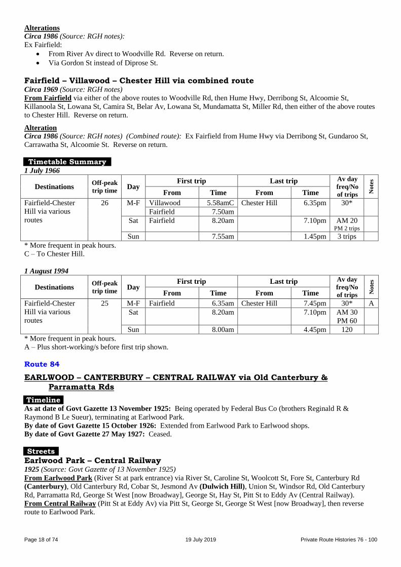
26 M-F Villawood 5.58amC Chester Hill 6.35pm 30*
Fairfield 7.50am
Sat Fairfield 8.20am 7.10pm AM 20 PM 2 trips
Sun 7.55am 1.45pm 3 trips
* More frequent in peak hours.
C – To Chester Hill.
1 August 1994
Destinations Off-peak
trip time Day
First trip Last trip Av day
freq/No
of trips No
tes
From Time From Time
Fairfield-Chester
Hill via various
routes
25 M-F Fairfield 6.35am Chester Hill 7.45pm 30* A
Sat 8.20am 7.10pm AM 30
PM 60
Sun 8.00am 4.45pm 120
* More frequent in peak hours.
A – Plus short-working/s before first trip shown.
Route 84
EARLWOOD – CANTERBURY – CENTRAL RAILWAY via Old Canterbury & Parramatta Rds
Timeline As at date of Govt Gazette 13 November 1925: Being operated by Federal Bus Co (brothers Reginald R &
Raymond B Le Sueur), terminating at Earlwood Park.
By date of Govt Gazette 15 October 1926: Extended from Earlwood Park to Earlwood shops.
By date of Govt Gazette 27 May 1927: Ceased.
Streets
Earlwood Park – Central Railway 1925 (Source: Govt Gazette of 13 November 1925)
From Earlwood Park (River St at park entrance) via River St, Caroline St, Woolcott St, Fore St, Canterbury Rd
(Canterbury), Old Canterbury Rd, Cobar St, Jesmond Av (Dulwich Hill), Union St, Windsor Rd, Old Canterbury
Rd, Parramatta Rd, George St West [now Broadway], George St, Hay St, Pitt St to Eddy Av (Central Railway).
From Central Railway (Pitt St at Eddy Av) via Pitt St, George St, George St West [now Broadway], then reverse
route to Earlwood Park.
Page 19
Page 19 of 74 19 July 2019 Private Route Histories 76 - 100
Earlwood – Central Railway Alteration
1926 (Source: Govt Gazette of 15 October 1926): Extended from Earlwood Park via River St, Louisa St, Thompson
St, Cameron St to William St (Earlwood). Reverse on return.
Timetable Summary September 1925
Destinations Off-peak
trip time Day
First trip Last trip Av day
freq/No
of trips No
tes
From Time From Time
Earlwood Park-
Central Railway
42 M-F Earlwood Pk 7.47am Central Rly 11.27pm 90
Sat 7.47am 11.27pm 90
Sun 1.42pm 11.27pm 90
Route 84
FLEMINGTON – CENTRAL RAILWAY via Arthur St
Timeline By date of Govt Gazette 22 February 1929: Commenced by Steer Bros.
1929: Transferred to Glenister & Mackenzie (Stan Glenister & Roy Mackenzie, who died in 1926)
31 October 1931: Ceased as competitive with Government railway or tram services under State Transport (Co-
ordination) Act.
Streets 1929 (Source: Govt Gazette of 22 February 1929)
From Flemington (Richmond Rd at Arthur St) via Richmond Rd, Tavistock St, Hampstead Rd, Arthur St, Mackenzie
St, Bridge St (Homebush), Parramatta Rd, George St West [now Broadway], George St, Hay St, Pitt St to Eddy Av
(Central Railway).
From Central Railway (Pitt St at Eddy Av) via Pitt St, George St, George St West [now Broadway], then reverse
route to Flemington.
Timetable Summary March 1930
Destinations Off-peak
trip time Day
First trip Last trip Av day
freq/No
of trips No
tes
From Time From Time
Flemington-Central
Railway
M-F Flemington 6.11am Central Rly 11.37pm 30
Sat 6.11am 11.37pm 30
Sun 7.41am 11.37pm 30
Route 84
EASTWOOD – HERRING & WATERLOO RDS, MARSFIELD [in current Macquarie Park] via Agincourt & Herring Rds
Timeline 14 October 1935: Eastwood – Herring & Waterloo Rds commenced, then or later operated by Francis Myers.
19 February 1936: Curtailed to run Eastwood – Herring & Agincourt Rds.
1936: Absorbed into 85.
Route 84
CHESTER HILL – CHESTER HILL (Barbers Rd)
CHESTER HILL – GUILDFORD
Timeline By 26 September 1947: Chester Hill – Guildford section of George R Sinclair’s 209 renumbered 84.
December 1950: Transferred to Roger Pattison (formerly a Sinclair driver). Traded as R & E Pattison, later R & E
Pattison & Son (son was Robert Pattison).
June 1960: New route, Chester Hill – Chester Hill (Barbers Rd), commenced.
1 July 1972: Transferred to Chester Hill Transit (related to Chester Hill-Bankstown Bus Service – Dewey family).
Page 20
Page 20 of 74 19 July 2019 Private Route Histories 76 - 100
3 February 1986: Transferred to Auburn Bus Services (Barry Briggs & Stephen Todd).
By May 1989: Barbers Rd trips altered to run as a diversion on selected Chester Hill – Guildford trips.
9 October 1989: Auburn Bus Service transferred to Ian Barden & Associates.
By July 1990: Sunday service provided over part of route by diversion of 73 trips.
1 August 1990: Auburn Bus Services formed an association with Nowra Coaches and trading name changed to
Auburn Coaches.
21 September 1990: Transferred to Crossley Bus Lines (Colin Crossley and Eddie Hayman)
July 1996: Renumbered 907 in the Sydney Region Route Number System (see Private Route Histories – Contract
Region 13).
Streets
Guildford – Chester Hill Circa 1948 (Source: Gregory’s Street Directory)
From Guildford (station) via Railway Tce, Mountford Av, Marian St, Guildford Rd, Bolton St, Henry St, Broughton
St, Orchardleigh St, Woodville Rd, Gurney Rd, Miller Rd, Virgil Av, Bent St, Waldron Rd (Chester Hill).
Circa 1969 (Source: RGH notes)
From Guildford (station, Railway Tce at Guildford Rd) via Railway Tce, Mountford Av, Talbot Rd, Guildford Rd,
Bolton St, Broughton St, Orchardleigh St (Old Guildford), Woodville Rd, Gurney Rd, Curtis Rd, Campbell Hill Rd,
Virgil Av, Priam St, Waldron Rd to Chester Hill station.
From Chester Hill (Waldron Rd at station) via Bent St, Virgil Av, then reverse route to Guildford Rd, then Railway
Tce to Guildford station.
Circa 1989 (Source: timetable)
Barbers Rd diversion: From Gurney Rd/Miller Rd via Miller Rd to Barbers Rd, then Miller Rd to Gurney Rd.
Chester Hill – Chester Hill (Barbers Rd) Circa 1969 (Source: RGH notes)
From Chester Hill (Waldron Rd at station) via Bent St, Virgil Av, Campbell Hill Rd, Gurney Rd, Miller Rd to
Barbers Rd (Chester Hill).
From Chester (Barbers Rd) (at Miller Rd) via reverse route to Virgil Av, then Priam St, Waldron Rd to Chester Hill
station.
Alteration
Circa 1985 (Source: timetable): Ex Barbers Rd from Miller Rd/Barbers Rd via Barbers Rd, Woodville Rd, Gurney
Rd, then return to Chester Hill.
Timetable Summary 26 September 1947
Destinations Off-peak
trip time Day
First trip Last trip Av day
freq/No
of trips No
tes
From Time From Time
Chester Hill-
Guildford
15 M-F Chester Hill 5.55am Chester Hill 7.00pm 60* A
Sat 6.13am 2.36pm 30-60 B
Sun Guildford 9.40am Guildford 8.38pm 60
* More frequent in peak hours.
A – Plus short-working/s before first trip shown.
B – Plus picture bus to Guildford. Plus short-working/s before first trip shown.
Page 21
Page 21 of 74 19 July 2019 Private Route Histories 76 - 100
1 November 1967
Destinations Off-peak
trip time Day
First trip Last trip Av day
freq/No
of trips No
tes
From Time From Time
Chester Hill-
Guildford
17 M-F Chester Hill 5.38am Guildford 7.21pm 60*
Sat 6.19am 7.23pm 40-60
Sun
Chester Hill-
Barbers Rd
10 M-F Barbers Rd 6.05am Chester Hill 7.40pm 13 trips
Sat 8.55am 6.40pm 5 trips
Sun
* More frequent in peak hours.
9 November 1981
Destinations Off-peak
trip time Day
First trip Last trip Av day
freq/No
of trips No
tes
From Time From Time
Chester Hill-
Guildford
17 M-F Chester Hill 5.30am Guildford 6.38pm 60*
Sat 7.16am 12.37pm 45
Sun
Chester Hill-
Barbers Rd
10 M-F Barbers Rd 5.17am Chester Hill 6.38pm 12 trips
Sat 9.30am 12.53pm 3 trips
Sun
* More frequent in peak hours.
Route 85
EASTWOOD – MACQUARIE UNIVERSITY – RYDE via Balaclava & Herring Rds
EASTWOOD – MIDWAY – FIVEWAYS Eastwood – Midway – Ryde via Bridge Rd (1963-66)
(Fiveways is located at Balaclava Rd/North Rd.)
(Midway is located at North Rd/Lovell Rd.)
(The suburb where Waterloo Rd & Macquarie University are located was known as Marsfield until gazetted as Macquarie Park in 1999.)
Timeline As at date of Govt Gazette 13 November 1925: Eastwood – Marsfield (Waterloo Rd) via Balaclava Rd being
operated by Francis Myers.
By October 1935: Operated by Myers & Dickson.
1936: 84 (Eastwood – Herring & Agincourt Rds) absorbed into 85. Two trips along ex-84 continued to run on
Saturday mornings until at least the currency of the timetable dated 21 January 1963.
By the late 1930s: 79 (Eastwood – Marsfield (Waterloo Rd) via Vimiera Rd) absorbed into 85. Service along
Lansdowne St, Lincoln St & Vimiera Rd (ex-79?) continued until June 1952.
January 1955: Transferred back to Francis Myers.
1950s (by or during Myers’ proprietorship): New route, Eastwood – Midway – Fiveways, commenced (destination
sign, “North Rd via Lovell Rd”).
June 1957: Transferred to Hunters Hill Bus Co (John A Gilbert family, majority shareholder; CAL (Clarrie) Paull,
manager till 1965, then KA (Ken) Butt).
18 November 1963: New route, Eastwood – Midway – Ryde via Bridge Rd, commenced.
20 July 1964: Eastwood – Macquarie University (future site of university, actually opened in March 1967) shared
with 141.
By 12 September 1966: Eastwood – Midway – Ryde via Bridge Rd renumbered 228.
By 29 December 1971: Selected trips extended from Macquarie University to AWA factory, North Ryde (later
referred to as North Ryde Industrial Area).
15 November 1976: As part of rearrangement of 85, 141 & 228:
Eastwood – Macquarie University extended from Macquarie University to (Top) Ryde, replacing 141.
Eastwood – Midway – Fiveways replaced by rerouting of 228.
28 April 1978: Transferred to North & Western Bus Lines (KA (Ken) Butt, proprietor).
Page 22
Page 22 of 74 19 July 2019 Private Route Histories 76 - 100
16 November 1981: Rerouted via Macquarie Centre, upon its opening.
30 June 1986: Selected trips diverted via Busaco Rd/Talavera Rd, Marsfield.
23 July 1990: As part of general reorganization of North & Western’s routes:
Eastwood – Macquarie University amalgamated with 54 and Parramatta – Eastwood via Main Rd section of
172 and renumbered 550 in the Sydney Region Route Number System (see Private Route Histories – Routes
transferred to State Transit Authority).
Ryde – Macquarie University remained as 85 (because of the then proposed amalgamation with Gordon –
Macquarie University to form a cross-suburban “Red Arrow” type route, which did not eventuate).
Service to the part of 85 in Marsfield between Epping Rd/Vimiera Rd & Waterloo Rd/Culloden Rd (not
covered by 550 Chatswood – Parramatta) replaced by an infrequent weekday service on 550, Eastwood –
Marsfield (Busaco Rd), commenced by North & Western Bus Lines. But a more regular service to the
Marsfield area was provided by an improved service on State Transit Authority (trading as Sydney Buses) 292
City (Wynyard) – Marsfield.
13 April 1993: Ryde – Macquarie University renumbered 531 in the Sydney Region Route Number System (see
Private Route Histories – Routes transferred to State Transit Authority).
Streets
Eastwood – Marsfield (Waterloo Rd) via Balaclava Rd 1925 (Source: Govt Gazette of 13 November 1925)
From Eastwood (Railway Pde at station) via Railway Pde, May St, Bennett [now Blaxland] Rd, Balaclava Rd,
Waterloo Rd to Khartoum Rd (North Ryde). Reverse on return.
Alteration
1928 (Source: Govt Gazette of 22 June 1928): Ex Eastwood from Railway Pde via Ethel St, Bennett [now Blaxland]
Rd. Reverse on return.
Eastwood – Marsfield (Vimiera & Waterloo Rds) Circa 1948 (Source: Gregory’s Street Directory)
From Eastwood (station) via Railway Pde, May St, Blaxland Rd, Lansdowne St, Gordon St, Balaclava Rd, Waterloo
Rd to Vimiera Rd (Marsfield [now Macquarie Park]).
Circa 1963 (Source: RGH notes)
From Eastwood (Railway Pde at station) via May St, Blaxland Rd, Balaclava Rd, Agincourt Rd, Vimiera Rd,
Waterloo Rd (Marsfield), Balaclava Rd, Blaxland Rd, Rowe St, Railway Pde to Eastwood station.
Eastwood – Macquarie University Alteration
Circa 1964 (Source: RGH notes): From Waterloo Rd via Culloden Rd, Epping Rd, Balaclava Rd to Macquarie
University.
By 1968 (Source: timetable)
From Eastwood (Railway Pde at station) via May St, Blaxland Rd, Balaclava Rd to Macquarie University.
From Macquarie University via Balaclava Rd, Blaxland Rd, Rowe St, Railway Pde to Eastwood station.
Vimiera Rd diversion: From Balaclava Rd/Agincourt Rd via Agincourt Rd, Yangalla St, Vimiera Rd, Epping Rd,
Balaclava Rd to Macquarie University. Reverse on return.
Eastwood – Macquarie University (extended to AWA, North Ryde) By 1970 (Source: timetable)
AWA, North Ryde extension: Extended from Macquarie University via Waterloo Rd, Khartoum Rd, Vittoria [now
Talavera] Rd to AWA factory (in Lane Cove Rd?), North Ryde. Reverse on return.
Eastwood – Macquarie University – Ryde 15 November 1976 (Source: timetable)
From Eastwood (station, Ethel St at Railway Pde) via May St, Blaxland Rd, Balaclava Rd, Agincourt Rd, Yangalla
St, Vimiera Rd, Epping Rd, Balaclava Rd (Macquarie University), Waterloo Rd, Herring Rd (North Ryde), Bridge
Rd, Watts Rd, North Rd, Quarry Rd, Lane Cove Rd, Devlin St to Top Ryde shops.
From Ryde (Devlin St at shops) via Blaxland Rd, Lane Cove Rd, then reverse route to Blaxland Rd, then Ethel St to
Eastwood station.
Page 23
Page 23 of 74 19 July 2019 Private Route Histories 76 - 100
Waterloo Rd diversion: Ex Eastwood from Vimiera Rd/Epping Rd via Vimiera Rd, Waterloo Rd, Culloden Rd to
Epping Rd. Reverse on return.
Fontenoy Rd diversion: Ex Eastwood from Waterloo Rd/Herring Rd via Waterloo Rd, Lane Cove Rd, Fontenoy Rd,
Khartoum Rd, Waterloo Rd to Herring Rd.
Alterations
16 November 1981 (opening date of Macquarie Centre shops) (Source: timetable):
Route through Macquarie University via Macquarie Dr.
Diverted through Macquarie Centre from Waterloo Rd via Herring Rd to Macquarie Centre and return.
Diversion via Lane Cove Rd, Fontenoy Rd & Khartoum Rd ceased.
Selected trips diverted ex Eastwood from Bridge Rd via Twin Rd, Boyce St, Quarry Rd, Gardener Av, Bidgee
St, Aitchandar Rd, Buffalo Rd to Lane Cove Rd. Reverse on return.
Eastwood – Midway – Fiveways Circa 1963 (Source: RGH notes)
From Eastwood (Railway Pde at station) via May St, Blaxland Rd, Balaclava Rd, Alexandria Av, Welby St, Pickford
St, Lovell Rd (Midway), North Rd to Balaclava Rd (Fiveways). (Selected trips continued back to Eastwood station
via Balaclava Rd, Blaxland Rd, Rowe St, Railway Pde.)
From Fiveways (Balaclava Rd/North Rd) via reverse route to Blaxland Rd, then Rowe St, Railway Pde to Eastwood
station. (Selected trips commenced from Eastwood station via May St, Blaxland Rd, Balaclava Rd to Fiveways.)
Alteration
From 5 August 1963 (Source: RGH notes): Ex Eastwood from Balaclava Rd via Gordon St, Welby St. Reverse on
return.
Eastwood – Midway – Ryde via Bridge Rd From 18 November 1963
From Eastwood (Railway Pde at station) via May St, Blaxland Rd, Lansdowne St, Gordon St, Welby St, Pickford
Av, Lovell Rd (Midway), North Rd, Watts Rd, Bridge Rd, Lane Cove Rd, Devlin St to Top Ryde shops.
From Ryde (Devlin St at shops) via Blaxland Rd, Lane Cove Rd, then reverse route to Lansdowne St, then Blaxland
Rd, Rowe St, Railway Pde to Eastwood station.
Timetable Summary September 1925
Destinations Off-peak
trip time Day
First trip Last trip Av day
freq/No
of trips No
tes
From Time From Time
Eastwood-
Marsfield
(Waterloo Rd)
14 M-F Agincourt Rd 6.30am Eastwood 6.58pm A
Waterloo Rd 8.30am
Sat Waterloo Rd 8.30am 10.56pm 40-60
Sun 8.55am 9.53pm 4 trips
A – Early morning, Eastwood-Agincourt Rd. Day, Eastwood-Waterloo Rd 30-60. Extra trips Friday night.
15 July 1957
Destinations Off-peak
trip time Day
First trip Last trip Av day
freq/No
of trips No
tes
From Time From Time
Eastwood-
Marsfield
(Waterloo Rd)
17 M-F Waterloo Rd 6.23am Eastwood 7.05pm 60* A
Sat 6.22am 7.15pm 60 B
Sun Epping Hwy 9.43am 6.57pm 4 trips C
Eastwood-Midway-
Fiveways
13 M-F Fiveways 6.10am Eastwood 7.03pm 60*
Sat 6.28am 6.26pm 30 B
Sun 9.52am 6.57pm 4 trips C
* More frequent in peak hours.
A – Plus short-working/s before first trip shown.
B – Selected Eastwood-Marsfield (Waterloo Rd) trips on Saturday ran via Midway. Gap in service.
C – All Eastwood-Epping Hwy trips on Sunday ran via Midway.
Page 24
Page 24 of 74 19 July 2019 Private Route Histories 76 - 100
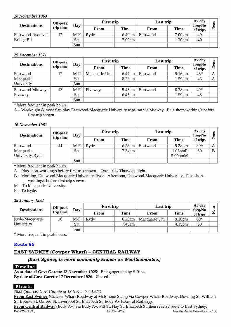
18 November 1963
Destinations Off-peak
trip time Day
First trip Last trip Av day
freq/No
of trips No
tes
From Time From Time
Eastwood-Ryde via
Bridge Rd
17 M-F Ryde 6.40am Eastwood 7.00pm 40
Sat 7.00am 1.20pm 40
Sun
29 December 1971
Destinations Off-peak
trip time Day
First trip Last trip Av day
freq/No
of trips No
tes
From Time From Time
Eastwood-
Macquarie
University
17 M-F Macquarie Uni 6.47am Eastwood 9.16pm 45* A
Sat 8.23am 1.59pm 45 A
Sun
Eastwood-Midway-
Fiveways
13 M-F Fiveways 5.48am Eastwood 8.28pm 40*
Sat 6.45am 1.59pm 45
Sun
* More frequent in peak hours.
A – Weeknight & most Saturday Eastwood-Macquarie University trips ran via Midway. Plus short-working/s before
first trip shown.
16 November 1981
Destinations Off-peak
trip time Day
First trip Last trip Av day
freq/No
of trips No
tes
From Time From Time
Eastwood-
Macquarie
University-Ryde
41 M-F Ryde 6.23am Eastwood 9.28pm 30* A
Sat 7.34am 1.05pmR
5.00pmM
30 B
Sun
* More frequent in peak hours.
A – Plus short-working/s before first trip shown. Extra trips Thursday night.
B – Morning, Eastwood-Macquarie University-Ryde. Afternoon, Eastwood-Macquarie University. Plus short-
working/s before first trip shown.
M – To Macquarie University.
R – To Ryde.
28 January 1992
Destinations Off-peak
trip time Day
First trip Last trip Av day
freq/No
of trips No
tes
From Time From Time
Ryde-Macquarie
University
20 M-F Ryde 6.20am Macquarie Uni 9.10pm 60*
Sat 7.45am 4.15pm 60
Sun
* More frequent in peak hours.
Route 86
EAST SYDNEY (Cowper Wharf) – CENTRAL RAILWAY
(East Sydney is more commonly known as Woolloomooloo.)
Timeline As at date of Govt Gazette 13 November 1925: Being operated by S Rice.
By date of Govt Gazette 17 December 1926: Ceased.
Streets 1925 (Source: Govt Gazette of 13 November 1925)
From East Sydney (Cowper Wharf Roadway at McElhone Steps) via Cowper Wharf Roadway, Dowling St, William
St, Bourke St, Oxford St, Liverpool St, Elizabeth St, Eddy Av (Central Railway).
From Central Railway (Eddy Av) via Eddy Av, Pitt St, Hay St, Elizabeth St, then reverse route to East Sydney.
Page 25
Page 25 of 74 19 July 2019 Private Route Histories 76 - 100
Alteration
1926 (Source: Govt Gazette of 15 October 1926): Ex Central Railway from Eddy Av via Elizabeth St.
Timetable Summary September 1925
Destinations Off-peak
trip time Day
First trip Last trip Av day
freq/No
of trips No
tes
From Time From Time
Woolloomooloo-
Central Railway
15 M-F W’mooloo 6.50am Central Rly 7.55pm 40 A
Sat 6.50am 2.00pm 40
Sun
A – Extra trips Friday night.
Route 86
EASTWOOD – CARLINGFORD via Rutledge St
Timeline By date of Govt Gazette 22 June 1928: Eastwood – Darvall Rd, Eastwood commenced by Reg White.
By date of Govt Gazette 22 February 1929: Extended from Darvall Rd to Lawson Rd.
1930s: Transferred to George R Sinclair.
By 3 April 1945: Extended from Lawson Rd to Church St [now Marsden Rd]/Pennant Hills Rd, Carlingford.
?: Operated by Parramatta-Epping Bus Service (Moore family) for a period (?).
December 1950: Transferred to Eastwood Bus Service (George R Sinclair) (& Carl Tattam?). At various times also
traded as Sinclair’s Passenger Service or Fleet Services.
By 28 February 1953: Extended from Church St [now Marsden Rd]/Pennant Hills Rd to Carlingford station.
1960/1 (between 9 April 1960 & 1 July 1961): Renumbered 150, as Eastwood – Dundas Valley – Parramatta trips on
172 were renumbered 86.
Streets
Eastwood – Eastwood (Darvall Rd) 1928 (Source: Govt Gazette of 22 June 1928)
From Eastwood (railway reserve at station) via West Pde, Clanalpine St, Shaftsbury Rd, Rutledge St, Darvall Rd to
Rowe St. Reverse on return.
Eastwood – Eastwood (Lawson St) 1929 (Source: Govt Gazette of 22 February 1929)
From Eastwood (railway reserve at station) via West Pde, Clanalpine St, Shaftsbury Rd, Rutledge St, Brush Rd,
Lawson St to Marsden Rd. Reverse on return.
Eastwood – Carlingford Circa 1946 (Source: Gregory’s Street Directory)
From Eastwood (station) via West Pde, Rowe St, Shaftsbury Rd, Rutledge St, Darvall St, Sybil St, Brush Rd, Lawson
St, Marsden Rd, Church St [now Marsden Rd] to Pennant Hills Rd (Carlingford).
Alterations
By 7 August 1955:
Extended (likely route) from Church St [now Marsden Rd]/Pennant Hills Rd via Pennant Hills Rd to
Carlingford station. Reverse on return.
Post Office Rd diversion (generally alternate trips): Ex Eastwood from Church St [now Marsden
Rd]/Pennant Hills Rd, Carlingford via Pennant Hills Rd, Post Office Rd, Jenkins Rd, Pennant Hills Rd to
Carlingford station.
Page 26
Page 26 of 74 19 July 2019 Private Route Histories 76 - 100
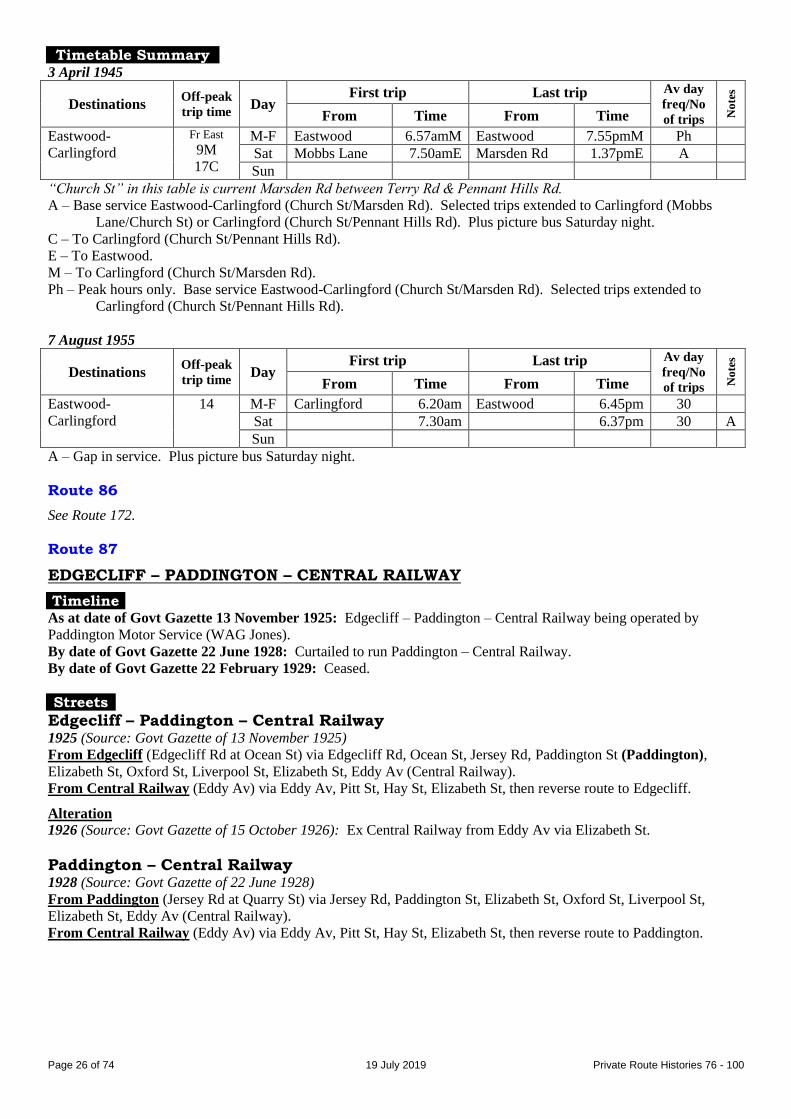
Timetable Summary 3 April 1945
Destinations Off-peak
trip time Day
First trip Last trip Av day
freq/No
of trips No
tes
From Time From Time
Eastwood-
Carlingford
Fr East
9M
17C
M-F Eastwood 6.57amM Eastwood 7.55pmM Ph
Sat Mobbs Lane 7.50amE Marsden Rd 1.37pmE A
Sun
“Church St” in this table is current Marsden Rd between Terry Rd & Pennant Hills Rd.
A – Base service Eastwood-Carlingford (Church St/Marsden Rd). Selected trips extended to Carlingford (Mobbs
Lane/Church St) or Carlingford (Church St/Pennant Hills Rd). Plus picture bus Saturday night.
C – To Carlingford (Church St/Pennant Hills Rd).
E – To Eastwood.
M – To Carlingford (Church St/Marsden Rd).
Ph – Peak hours only. Base service Eastwood-Carlingford (Church St/Marsden Rd). Selected trips extended to
Carlingford (Church St/Pennant Hills Rd).
7 August 1955
Destinations Off-peak
trip time Day
First trip Last trip Av day
freq/No
of trips No
tes
From Time From Time
Eastwood-
Carlingford
14 M-F Carlingford 6.20am Eastwood 6.45pm 30
Sat 7.30am 6.37pm 30 A
Sun
A – Gap in service. Plus picture bus Saturday night.
Route 86
See Route 172.
Route 87
EDGECLIFF – PADDINGTON – CENTRAL RAILWAY
Timeline As at date of Govt Gazette 13 November 1925: Edgecliff – Paddington – Central Railway being operated by
Paddington Motor Service (WAG Jones).
By date of Govt Gazette 22 June 1928: Curtailed to run Paddington – Central Railway.
By date of Govt Gazette 22 February 1929: Ceased.
Streets
Edgecliff – Paddington – Central Railway 1925 (Source: Govt Gazette of 13 November 1925)
From Edgecliff (Edgecliff Rd at Ocean St) via Edgecliff Rd, Ocean St, Jersey Rd, Paddington St (Paddington),
Elizabeth St, Oxford St, Liverpool St, Elizabeth St, Eddy Av (Central Railway).
From Central Railway (Eddy Av) via Eddy Av, Pitt St, Hay St, Elizabeth St, then reverse route to Edgecliff.
Alteration
1926 (Source: Govt Gazette of 15 October 1926): Ex Central Railway from Eddy Av via Elizabeth St.
Paddington – Central Railway 1928 (Source: Govt Gazette of 22 June 1928)
From Paddington (Jersey Rd at Quarry St) via Jersey Rd, Paddington St, Elizabeth St, Oxford St, Liverpool St,
Elizabeth St, Eddy Av (Central Railway).
From Central Railway (Eddy Av) via Eddy Av, Pitt St, Hay St, Elizabeth St, then reverse route to Paddington.
Page 27
Page 27 of 74 19 July 2019 Private Route Histories 76 - 100
Timetable Summary September 1925
Destinations Off-peak
trip time Day
First trip Last trip Av day
freq/No
of trips No
tes
From Time From Time
Edgecliff-Central
Railway
22 M-F Edgecliff 6.51am Central Rly 7.03pm 20-30 A
Sat 6.51am 7.00pm 20-30
Sun
A – Extra trips Friday night.
Route 87
CANTERBURY – EARLWOOD – DULWICH HILL
Timeline Unknown: Commenced by United Motors (McNicol Bros).
1 March 1937: Taken over by Department of Road Transport & Tramways & amalgamated with 38, 213 &
Department of Road Transport & Tramways 90, as 90, Drummoyne – Campsie – Earlwood.
Route 87
BEECROFT – EASTWOOD – WEST RYDE
Timeline October 1946: Eastwood –West Ryde commenced by Eric J Barton, also trading as Red & White Bus Service.
Eastwood – Denman St commenced either at same time or by 19 May 1947.
September/October 1952:
Eastwood – Denman St amalgamated with Eastwood – Epping – Beecroft section of 91 as 87, Denman St –
Eastwood – Epping – Beecroft.
At least during the currency of the 13 October 1952 timetable routes ran separately:
Eastwood – Denman St
Eastwood – Epping – Beecroft
It is not clear if the same operator continued to operate Eastwood – West Ryde in the period 1952-1955.
Circa 1955:
Eastwood – Beecroft transferred to JL Adams and renumbered 138.
87 then became:
Eastwood – West Ryde
Eastwood – Denman St.
September 1956: Transferred to Eastwood Bus Service (George R Sinclair & Colin Sinclair). At various times also
traded as Sinclair’s Passenger Service or Fleet Services.
November 1960: Transferred to CA Briggs.
October 1961: Transferred to Eastwood-West Ryde Bus Service (DL Jones).
By 26 December 1961: Eastwood – West Ryde and Eastwood – Denman St combined into a single route, Eastwood
– West Ryde, with selected trips diverting via Denman St loop.
By 1 April 1964:
Extended to operate via Marsden High School
Diversion via Denman St ceased.
November 1965: Transferred to Griffith’s Bus Service (Mrs E Griffith).
31 October 1967: Transferred to Eastwood-West Ryde Bus Service (John E Burke).
4 August 1977: Transferred to Cumberland Bus Co (Todd family).
31 August 1981: Transferred to Metro West Bus Lines (KA (Ken) Butt).
23 July 1990:
Renumbered 543 in the Sydney Region Route Number System (see Private Route Histories – Routes
transferred to State Transit Authority).
Operator’s name changed to North & Western Bus Lines.
Streets
Eastwood – West Ryde Circa 1948 (Source: Gregory’s Street Directory)
From Eastwood (station) via West Pde, Rowe St, Shaftesbury Rd, Trelawney St, Bellevue Av, Bencoolen Av,
Chatham Rd, Victoria Rd, West Pde (West Ryde).
Page 28
Page 28 of 74 19 July 2019 Private Route Histories 76 - 100
Circa 1963 (Source: RGH notes)
From Eastwood (West Pde at station) via West Pde, Rowe St, Shaftsbury Rd, Clanwilliam St, Darvall Rd, Tramway
St, Brush Rd, Hermoyne Av, (left) Winbourne St, Farnell St, Winbourne St East, Hermoyne Av, Tramway St, Driver
St, Perkins St, Brush Rd, Shaftsbury Rd, Beaumont Av, Bellevue Av, Bencoolen Av, Chatham Rd, Graf Av, Anthony
Rd to West Ryde interchange.
From West Ryde (interchange) via reverse route to Hermoyne Av, then (left) Winbourne St, Farnell St, Winbourne St
East, Hermoyne Av, then reverse route to Eastwood station.
Alterations
Circa 1968 (Source: RGH notes) (most trips): From Farnell St via Bell Av to Winbourne St (instead of loop
via Farnell St & Winbourne St East).
Circa 1982 (Source: timetable): Ex Eastwood from Clanwilliam St via Read St, Warrawong St, Brush Rd.
Reverse on return.
Circa 1985 (Source: timetable): To approach Eastwood from Rowe St via The Avenue, Lakeside Rd,
Hillview Rd to Eastwood station. Reverse on return.
Timetable Summary Early 1950s(?)
Destinations Off-peak
trip time Day
First trip Last trip Av day
freq/No
of trips No
tes
From Time From Time
Eastwood (Darvall
St)-Epping-
Beecroft
Fr Beec
25E
28D
M-F Beecroft 7.35amD Beecroft 6.08pm D 60* A
Sat Eastwood stn 7.00amB Eastwood 1.10pmB 40-60 C
Sun
* More frequent in peak hours.
A – Plus short-working/s before first trip & after last trip shown.
B – To Beecroft.
C – Service between Eastwood station & Eastwood (Darvall Rd) provided by Eastwood-West Ryde trips (?). Plus
picture bus.
D – To Eastwood (Darvall Rd).
E – To Eastwood station.
26 December 1961
Destinations Off-peak
trip time Day
First trip Last trip Av day
freq/No
of trips No
tes
From Time From Time
Eastwood-West
Ryde
16 M-F Darvall Rd 6.59amW West Ryde 6.44pmE 60*
Eastwood 7.46amW
Sat Eastwood 8.16amW 1.21pmE 40
Sun
* More frequent in peak hours.
E – To Eastwood.
W – To West Ryde.
Route 88
ENFIELD – CENTRAL RAILWAY
Timeline As at date of Govt Gazette 13 November 1925: Being operated by Metropolitan Omnibus & Transport Co (FH
(later Sir Frederick) Stewart).
31 October 1931: Ceased as competitive with Government railway or tram services under State Transport (Co-
ordination) Act.
Streets 1925 (Source: Govt Gazette of 13 November 1925)
From Enfield (The Boulevarde at Liverpool Rd) via The Boulevarde, Liverpool Rd (Ashfield), Parramatta Rd,
George St West [now Broadway], George St, Hay St, Pitt St to Eddy Av (Central Railway).
From Central Railway (Pitt St at Eddy Av) via Pitt St, George St, George St West [now Broadway], then reverse
route to Enfield.
Page 29
Page 29 of 74 19 July 2019 Private Route Histories 76 - 100
Timetable Summary September 1925
Destinations Off-peak
trip time Day
First trip Last trip Av day
freq/No
of trips No
tes
From Time From Time
Enfield-Central
Railway
42 M-F Enfield 6.30am Central Rly 10.45pm 5
Sat 6.30am 10.45pm 5
Sun 8.54am 10.45pm AM 15
PM 10
March 1930
Destinations Off-peak
trip time Day
First trip Last trip Av day
freq/No
of trips No
tes
From Time From Time
Enfield-Central
Railway
M-F Enfield 6.15am Central Rly 12.35am 5
Sat 6.15am 12.35am 5
Sun 8.20am 12.35am 10
Route 88
BANKSTOWN – PADSTOW – HURSTVILLE
Timeline 21 June 1948: Bankstown – Padstow commenced by ED Benjamin.
November 1953: Transferred to West Bankstown Bus Service (Treuer family).
12 September 1964: Following the opening of bridge taking Henry Lawson Dr over Salt Pan Creek the previous day:
Transferred to Peakhurst/Lugarno Bus Co (HT Saint) and extended from Padstow to Hurstville, replacing
Hurstville – Peakhurst (Elwyn St) trips of 108.
On Sundays and Public Holidays 88 was combined with 113 to run Bankstown – Hurstville – Ramsgate.
1 March 1989:
Transferred to Menai Bus Service (Ron Deane).
Sundays & Public Holidays service curtailed to Bankstown – Hurstville.
July 1989: Trading name of operator changed to Southtrans.
12 October 1992: Renumbered 948 in the Sydney Region Route Number System (see Private Route Histories –
Contract Region 10/11).
Streets
Bankstown – Padstow Circa 1962 (Source: Collins Street Directory)
Similar to circa 1968 below between Bankstown and Padstow.
Bankstown – Padstow – Hurstville Circa 1968 (Source: RGH notes)
From Bankstown (South Tce at station) via Restwell St, Stanley St, Stacey St, Canterbury Rd, Fairford Rd, Davies
Rd, Ryan Rd, Faraday Rd, Padstow Pde, Howard Rd (Padstow), Ryan Rd, Davies Rd, Alma Rd, Dilke Rd, Henry
Lawson Dr, Forest Rd, Bonds Rd, Bailey Pde, Baumans Rd, Forest Rd, George St (Penshurst), Cambridge St, Forest
Rd, Alfred St, Treacey St (Hurstville).
From Hurstville (Treacey St) via Forest Rd, Cambridge St, then reverse route to Davies Rd, then Ryan Rd, Faraday
Rd, Padstow Pde, Howard Rd (Padstow), Ryan Rd, Davies Rd, then reverse route to Restwell St, then Greenfield St,
Chapel Rd, South Tce to Bankstown station.
Trips via Forest Rd direct: Ex Bankstown from Henry Lawson Dr via Forest Rd, George St (not via Bonds Rd,
Bailey Pde, Baumans Rd). Reverse on return.
Alterations
Circa 1981 (Source: RGH notes): All trips ex Bankstown from Henry Lawson Dr via Forest Rd, George St
(not via Bonds Rd, Bailey Pde, Baumans Rd). Reverse on return.
Circa 1989 (Source: timetable): To approach Bankstown from Chapel Rd via South Tce, West Tce,
Raymond St, Restwell St to Bankstown station. Return via South Tce, West Tce, Raymond St, Cross St,
Stanley St, Chapel Rd.
Page 30
Page 30 of 74 19 July 2019 Private Route Histories 76 - 100
Circa 1989 (Source: timetable): Ex Bankstown, via Chapel St direct to Fairford Rd instead of Canterbury Rd.
Reverse on return.
Circa 1989 (Source: timetable): Ex Bankstown from Davies Rd (south of Padstow) via Clancy St, Henry
Lawson Dr. Reverse on return.
Timetable Summary 5 September 1960
Destinations Off-peak
trip time Day
First trip Last trip Av day
freq/No
of trips No
tes
From Time From Time
Bankstown-
Padstow
16 M-F Padstow 5.43am Padstow 7.11pm 40* A
Sat Bankstown 7.15am 7.10pm AM 20
PM 60
B
Sun 6.35am 7.21pm AM 60
PM 40
C
* More frequent in peak hours.
A – Plus short-working/s before first trip shown.
B – Plus picture bus Saturday night.
C – Gap in service.
22 September 1981
Destinations Off-peak
trip time Day
First trip Last trip Av day
freq/No
of trips No
tes
From Time From Time
Bankstown-
Padstow-
Hurstville†
Fr Banks
35H
50R
M-F Hurstville 6.32am Bankstown 7.26pm 30* A
Sat 7.20am 7.15pm AM 30
PM 60
Sun Bankstown 9.30am Ramsgate 5.30pm 60 B
* More frequent in peak hours.
† Through-routed with 113 to Ramsgate on Sundays.
A – Plus short-working/s before first trip shown. Extra trips Thursday night.
B – Through-routed with 113. Plus short-working/s before first trip & after last trip shown.
H – To Hurstville.
R – To Ramsgate.
Route 88
CABRAMATTA FREE SHUTTLE
Listed at the head of Private Route Histories - Contract Region 3, as its commencement date of 2011 indicates that it
belongs to Contract Region 3, rather than the 1925 numbering system.
Route 89
EPPING – EASTWOOD – RYDE
Extended from Epping station to Epping (Malton Rd) [in current North Epping] (until 1934)
Extended from Ryde to Gladesville (until circa 1928)
Ryde Post Office – [West] Ryde Station (1934-36)
(Ryde Post Office located in what is also referred to as Top Ryde.)
(Ryde station was renamed West Ryde in October 1945.)
Timeline As at date of Govt Gazette 13 November 1925: Epping (Malton Rd) – Epping – Eastwood – Ryde Post Office
(selected trips extended to Gladesville) being operated by Cedric ME Troy, then or later trading as Troy’s Bus
Service.
By date of Govt Gazette 22 June 1928: Ryde Post Office – Gladesville extension ceased. Ryde – Gladesville
already served by the Fort Macquarie – Ryde tram service.
Page 31
Page 31 of 74 19 July 2019 Private Route Histories 76 - 100
12 March 1934:
Extended from Ryde Post Office to [West] Ryde station, as a replacement for the Ryde – Ryde station tram
service, which closed at that time. For reasons that are not obvious, this part of the route was deemed
competitive with trams or trains under the State Transport (Co-ordination) Act as from 12 March 1934 and
paid tax until tax suspended on 21 August 1934.
Epping – Malton Rd, [North] Epping transferred to E Miles(?) & amalgamated with 82 as 82, Malton Rd –
Epping – Ray Rd.
6 May 1934: Ryde Post Office – [West] Ryde station extension split off as a separate route.
12 July 1936: Ryde Post Office – [West] Ryde station transferred to Department of Road Transport & Tramways &
renumbered 94, leaving route as Epping – Eastwood – Ryde Post Office.
1951: Transferred to Mrs Beatrice L Troy on death of Mr Troy.
November 1962: Transferred to Eastwood Bus Co (Col Sinclair & Carl N Tattam).
5 August 1965: Sinclair assumed full control.
6 July 1973: Transferred to Deane’s Coaches.
30 June 1986: Transferred to Metro West Bus Lines (KA (Ken) Butt).
23 July 1990: As part of general reorganization of North & Western’s & Metro-West’s routes:
Eastwood – Epping renumbered 541 in the Sydney Region Route Number System (see Private Route
Histories – Routes transferred to State Transit Authority).
Ryde shops – Eastwood amalgamated with Parramatta – Eastwood via Dundas Valley section of 172 and
renumbered 545 in the Sydney Region Route Number System (see Private Route Histories – Routes
transferred to State Transit Authority).
Operator’s name standardised as North & Western Bus Lines.
Streets
Epping [now North Epping] (Malton Rd) – Epping – Eastwood – Ryde (selected trips
extended to Gladesville) 1925 (Source: Govt Gazette of 13 November 1925)
From Epping (Malton Rd at Stanley [now Devon] St) via Malton Rd, Norfolk St, Oxford St, Sutherland Rd [now
Langston Pl], Bridge St, Victoria St, Chesterfield St, Epping Av, Eastwood Av (Eastwood), Blaxland Rd [part now
Rowe St, including railway bridge], Great North [now Blaxland] Rd, Hattons Flat (Ryde shops). Reverse on return.
Gladesville extension: Extended from Ryde via Great North Rd [now Blaxland Rd, Victoria Rd] to Pittwater Rd
(Gladesville). Reverse on return.
Epping [now North Epping] (Malton Rd) – Epping – Eastwood – Ryde Alteration
1928 (Source: Govt Gazette of 22 June 1928): Curtailed from Gladesville to terminate at Ryde shops (at Post Office,
Great North Rd [now Blaxland Rd] at Church St).
Epping – Eastwood – Ryde Circa 1946 (Source: Gregory’s Street Directory)
From Epping (station) via Beecroft Rd, Bridge St, Victoria St, Chesterfield Rd, Midson Rd, Eastwood Av, West Pde,
Eastwood railway bridge, East Pde (Eastwood), Ethel St, Blaxland Rd, Devlin St (Ryde shops).
Circa 1964 (Source: RGH notes)
From Epping (Beecroft Rd at station) via Bridge St, Victoria St, Chesterfield Rd, Midson Rd, Eastwood Av, West
Pde, Rutledge St, East Pde (Eastwood), May St, Blaxland Rd, Dalton Av, Denistone Rd, Florence Av, Blaxland Rd,
Devlin St to Ryde shops.
From Ryde (Devlin St at shops) via Blaxland Rd, then reverse route to Bridge St, then Rawson St, Carlingford Rd,
Beecroft Rd to Epping station.
Trips via Blaxland Rd direct: Direct via Blaxland Rd from Dalton Av to Florence Av (not via Denistone Rd).
Reverse on return.
North Rd/Rickard St diversion: Ex Epping from Blaxland Rd/Rickard St via Rickard St, North Rd to Blaxland Rd.
Reverse on return.
Alterations
Circa 1979 (Source: timetable): To approach Epping from Bridge St via Beecroft Rd to Epping station.
Return via Carlingford Rd, Rawson St, Bridge St.
Circa 1979 (Source: timetable): Ex Epping from West Pde via Rowe St, Shaftsbury Rd, Rutledge St.
Reverse on return.
Page 32
Page 32 of 74 19 July 2019 Private Route Histories 76 - 100
Circa 1983 (Source: timetable): Ex Epping from Rowe St via Trelawney St, Rutledge St. Reverse on return.
Circa 1983 (Source: timetable):
North Rd/Rickard St diversion: Ex Ryde shops from North Rd via Beattie Av to Blaxland Rd. Unaltered
ex Epping.
Circa 1984 (Source: timetable): Ex Epping from West Pde via Hillview Rd, Lakeside Rd, The Avenue, Rowe
St, Trelawney St. Reverse on return.
Timetable Summary September 1925
Destinations Off-peak
trip time Day
First trip Last trip Av day
freq/No
of trips No
tes
From Time From Time
Epping (Malton
Rd)-Epping†
55 M-F Malton Rd 6.35am Epping 6.55pm 30-120 A
Sat 7.25am 7.50pm 8 trips A
Sun
† Selected trips extended to Gladesville.
A – 4 trips extended from Epping to Gladesville. Extra trips Friday night.
30 March 1942
Destinations Off-peak
trip time Day
First trip Last trip Av day
freq/No
of trips No
tes
From Time From Time
Epping-Ryde 25 M-F Epping 6.04am Ryde 11.45pm A
Sat 7.03am 10.37pm B
Sun 8.31am 11.11pm C
* More frequent in peak hours.
A – Epping-Ryde 60*, Eastwood-Ryde 30*.
B – Morning, Epping-Ryde 30. Afternoon, Epping-Ryde 60, Eastwood-Ryde 30. Plus picture bus to Ryde Saturday
night.
C – Epping-Ryde 60, Eastwood-Ryde 30.
11 July 1963
Destinations Off-peak
trip time Day
First trip Last trip Av day
freq/No
of trips No
tes
From Time From Time
Epping-Ryde 22 M-F Epping 6.00am Ryde 7.43pm 20*
Sat 7.15am 8.00pm AM 20
PM 30
Sun 9.20am 7.15pm 60 A
* More frequent in peak hours.
A – Plus selected short-working/s Eastwood-Ryde.
19 October 1974
Destinations Off-peak
trip time Day
First trip Last trip Av day
freq/No
of trips No
tes
From Time From Time
Epping-Ryde 24 M-F Epping 5.57am Ryde 6.50pm 30*
Sat 7.15am 4.30pm AM 30
PM 60
Sun
* More frequent in peak hours.
Route 90
DRUMMOYNE – FIVE DOCK – CROYDON – CAMPSIE
Timeline As at date of Govt Gazette 13 November 1925: Five Dock – Campsie being operated by Rod Smith.
By date of Govt Gazette 15 October 1926: Extended from Five Dock to Drummoyne
1928/9(?): Transferred to Glenister & Mackenzie (Stan Glenister & Roy Mackenzie, who died in 1926).
23 April 1933: Taken over by Department of Road Transport & Tramways.
Page 33
Page 33 of 74 19 July 2019 Private Route Histories 76 - 100
Streets
Five Dock – Croydon – Campsie 1925 (Source: Govt Gazette of 13 November 1925)
From Campsie (station, South Pde at Beamish St) via South Pde, Beamish St, Brighton Av (Croydon Park),
Georges River Rd, Brighton St, Liverpool Rd, Edwin St, Thomas St, The Strand (Croydon), Meta St, Hennessy St,
Edwin St, Anthony St, Croydon Rd, Parramatta Rd, Great North Rd to First Av (Five Dock). Reverse on return.
Drummoyne – Five Dock – Croydon – Campsie Alterations
1926 (Source: Govt Gazette of 15 October 1926): Extended from Five Dock (Great North Rd/First Av) via
Great North Rd, Lyons Rd to Bridge St [now Victoria Rd] (Drummoyne). Reverse on return.
1926 (Source: Govt Gazette of 15 October 1926): Ex Drummoyne from Liverpool Rd via Croydon Rd,
Georges River Rd. Reverse on return.
1928 (Source: Govt Gazette of 2 June 1928): Ex Drummoyne from Liverpool Rd via Greenhills St, Georges
River Rd. Reverse on return.
Timetable Summary September 1925
Destinations Off-peak
trip time Day
First trip Last trip Av day
freq/No
of trips No
tes
From Time From Time
Five Dock-Campsie 23 M-F Five Dock 6.15am Canpsie 10.52pm 30
Sat 6.15am 10.52pm 30
Sun 1.20pm 10.55pm 30
Route 90
EPPING – CARLINGFORD – NORTH ROCKS via Carlingford Rd
Extended from Carlingford to Parramatta (selected trips)
Timeline
General note: See also Supplementary route to Routes 90 & 181 (below).
1952: Epping – Carlingford commenced by Parramatta-Epping Bus Service (Moore family).
1950s: Certain trips (at least at one time, mainly those on Saturdays) extended from Carlingford to Parramatta.
November 1958: Operator’s name changed to Harris Park Transport.
By 1959: Reduced to a peak-hour service. Off-peak service provided by selected 165 trips already running via
Carlingford Rd.
1971:
Extended from Carlingford to North Rocks.
Extension from Carlingford to Parramatta probably ceased at the same time. Service to Parramatta available
on 165.
By 28 January 1975: Service reverted to operation throughout the day.
13 January 1992: Combined 82/90 trips, Epping – Carlingford – North Rocks via Ray Rd, introduced on Saturdays.
4 November 1996: 82 & 90 reorganised and renumbered into the Sydney Region Route Number System (see Private
Route Histories – Routes transferred to State Transit Authority):
628 Epping – Carlingford
629 Epping – North Rocks.
Streets
Epping – Carlingford Circa 1964 (Source: RGH notes)
From Epping (Beecroft Rd at station) via Bridge St, Rawson Rd, Carlingford Rd, Pennant Pde, Tomah St, Church St
[now Marsden Rd], Pennant Hills Rd (to Carlingford station?).
From Carlingford via reverse route to Carlingford Rd, then Beecroft Rd to Epping station.
Trips terminating at Pennant Pde: Ex Epping from Carlingford Rd via Pennant Pde, Dent St, Dallwood Av to
Carlingford Rd, then return to Epping.
Page 34
Page 34 of 74 19 July 2019 Private Route Histories 76 - 100
Epping – Carlingford – North Rocks 1981 (Source: timetable)
Morning peak hour From Epping (Beecroft Rd at station) via Carlingford Rd, Pennant Hills Rd (Carlingford), North Rocks Rd, Barclay
Rd, Perry St, Williams Rd/Sophia St loop (? direction) (North Rocks), Perry St, Barclay Rd, North Rocks Rd, Watts
St, Blackburn Av, New North Rocks Rd, McDonald St, Paragon Dr, Poinsettia Av, Balaka Dr, Farnell Av, Lindisfarne
Cr, Parkland Rd, Jenkins Rd, Woodstock Rd, Pennant Hills Rd, Carlingford Rd, Rawson St, Bridge St, Beecroft Rd to
Epping station.
Middle of day From Epping (Beecroft Rd at station) via Carlingford Rd, Pennant Hills Rd (Carlingford), Woodstock Rd, Jenkins
Rd, Parkland Rd, Lindisfarne Cr, Farnell Av, Lindisfarne Cr, Balaka Dr, Poinsettia Av, Paragon Dr, McDonald St,
New North Rocks Rd, Blackburn Av, Watts St, North Rocks Rd, Barclay Rd, Perry St, Williams Rd/Sophia St loop (?
direction) (North Rocks), Perry St, Barclay Rd, then reverse route to Carlingford Rd, then Rawson St, Bridge St,
Beecroft Rd to Epping station.
Afternoon peak hour From Epping via “middle of day” route to Williams Rd/Sophia St loop (North Rocks), then Perry St, Barclay Rd,
North Rocks Rd, Pennant Hills Rd, Carlingford Rd, Rawson St, Bridge St, Beecroft Rd to Epping station.
Timetable Summary 5 March 1959
Destinations Off-peak
trip time Day
First trip Last trip Av day
freq/No
of trips No
tes
From Time From Time
Epping-
Carlingford
12 M-F Carlingford 6.12am Epping 6.54pm Ph
Sat
Sun
Ph – Peak hours only. Selected trips ran only Epping-Pennant Pde.
28 January 1975
Destinations Off-peak
trip time Day
First trip Last trip Av day
freq/No
of trips No
tes
From Time From Time
Epping-North
Rocks
25 M-F Nth Rocks 5.58am Epping 6.25pm 50
Sat
Sun
28 June 1993
Destinations Off-peak
trip time Day
First trip Last trip Av day
freq/No
of trips No
tes
From Time From Time
Epping-North
Rocks
29 M-F Nth Rocks 5.52am Epping 7.45pm 60*
Sat 7.50am 4.25pm 60 A
Sun
* More frequent in peak hours.
A – Combined with 82.
Supplementary route to Routes 90/181
EPPING – CARLINGFORD – BEECROFT
Timeline By 19 July 1965: Commenced by Harris Park Transport (Moore family), being “supplementary to 90 & 181”.
(?): Ceased.
Streets
19 July 1965 (Source: timetable)
From Epping (Beecroft Rd at station) via Bridge St, Rawson Rd, Carlingford Rd, Dallwood Av, Dent St, Pennant
Pde, Carlingford Rd, Pennant Hills Rd (Carlingford), Post Office Rd, Jenkins Rd, North Rocks Rd, Pennant Hills Rd,
Murray Farm Rd, Kirkham Rd, Beecroft Rd, Railway Pde [now Wongala Cr] to Beecroft station.
Page 35
Page 35 of 74 19 July 2019 Private Route Histories 76 - 100
Timetable Summary 19 July 1965
Destinations Off-peak
trip time Day
First trip Last trip Av day
freq/No
of trips No
tes
From Time From Time
Epping-Beecroft 26 M-F Epping 7.33am Beecroft 5.35pm 7 trips A
Sat
Sun
A – Plus short-working/s before first trip and after last trip shown.
Route 91
FIVE DOCK – CENTRAL RAILWAY via Ramsay St & Parramatta Rd Extended from Five Dock to Abbotsford (selected trips)
Timeline As at date of Govt Gazette 13 November 1925: Being operated by EK Munro.
By date of Govt Gazette 15 October 1926: Ceased.
Streets 1925 (Source: Govt Gazette of 13 November 1925)
From Five Dock (Hampden Rd at Great North Rd) via Hampden Rd, Great North Rd, Ramsay St, Marion St,
Hawthorne Pde, Parramatta Rd, George St West [now Broadway], George St, Hay St, Pitt St to Eddy Av (Central
Railway).
From Central Railway (Pitt St at Eddy Av) via Pitt St, George St, George St West [now Broadway], then reverse
route to Five Dock.
Abbotsford extension: Extended from Five Dock via Great North Rd, Teviot Av to near Great North Rd
(Abbotsford). Reverse on return.
Timetable Summary September 1925
Destinations Off-peak
trip time Day
First trip Last trip Av day
freq/No
of trips No
tes
From Time From Time
Five Dock-Central
Railway†
Fr C/Rly
37F
42A
M-F Five Dock 5.25am Central Rly 11.52pm 40-60 B
Sat 5.25am 12.40am 40-60 B
Sun Abbotsford 7.42am 12.08am 40-60
† Selected trips extended to Abbotsford.
A – To Abbotsford.
B – 4 trips extended from Five Dock to Abbotsford Monday-Saturday. Extra trip Friday night.
F – To Five Dock.
Route 91
PENNANT HILLS – WEST PENNANT HILLS [now Cherrybrook] – DURAL via New Line Rd
Extended from Pennant Hills to Beecroft, Epping or Eastwood (1930s-1950s) Parramatta – Cherrybrook – Dural (peak hours)
(The current suburb of Cherrybrook was part of West Pennant Hills until about 1980. From the early 1980s until 1991, it was referred to in timetables as the
Greenway Estate.)
Timeline By date of Govt Gazette 22 February 1929: Epping – Pennant Hills commenced by FA Wallis.
By 1935:
Altered to Epping – West Pennant Hills (not via Pennant Hills) (by August 1941 running via Koala Park).
Transferred to T Alderson (?). (Timetable dated August 1941 shows FA Wallis as proprietor. Truck & Bus
Transportation, May 1946, shows route transferred from Wallis to Griffith.)
Page 36
Page 36 of 74 19 July 2019 Private Route Histories 76 - 100
May 1946:
Transferred to AJ (Jim) Griffith.
Extended from Epping to Eastwood.
By 1 May 1950:
Most trips terminated at Purchase Rd, West Pennant Hills, but selected trips extended to Hastings Rd, West
Pennant Hills.
Ran either via Pennant Hills station or via Thompsons Corner.
September/October 1952:
Eastwood – Epping – Beecroft amalgamated with 87 as 87, West Ryde – Eastwood – Epping – Beecroft,
leaving 91 as Beecroft – Pennant Hills – West Pennant Hills.
Most trips terminated at Purchase Rd or Radley [now David] Rd, West Pennant Hills, but selected trips
extended to Hastings Rd.
(?) (during AJ Griffith’s proprietorship): Base service became Pennant Hills – West Pennant Hills, but selected trips
extended from Pennant Hills to Beecroft.
January 1959: Transferred to Arthur E Higson & Bernie Best.
By 18 September 1961:
Beecroft – Pennant Hills ceased without replacement, leaving route as Pennant Hills – West Pennant Hills.
Most trips terminated at Purchase Rd, West Pennant Hills, but selected trips extended to David Rd, West
Pennant Hills (destination sign “New Line Rd via Victoria Rd”).
By November 1962: Transferred to KFA (Keith) & NW Pye.
February 1963: Transferred to Pennant Hills-Dural Transport (Col Sinclair).
13 January 1964: Transferred to Nicholson Bros (AC (Colin) & KN (Nigel) Nicholson), also known as Pennant
Hills-Dural Bus Service.
By February 1965: Most trips terminated at Purchase Rd, but selected trips extended to Dural (New Line Rd/Old
Northern Rd).
By 1981: Selected trips ran via Francis Greenway Dr, Greenway Estate (new suburb, now part of Cherrybrook).
1 July 1982: Transferred to Sandy Beach Bus Co, trading as Harris Park Transport (Moore family).
By 25 October 1982: Extra route, Pennant Hills – Cherrybrook, commenced.
By January 1983: Separate Pennant Hills – Cherrybrook route ceased and certain Pennant Hills – Dural trips
rerouted through Cherrybrook.
From 21 May 1984 to 21 August 1984: (Another) trial service Pennant Hills – Cherrybrook via Purchase Rd
(assumed unsuccessful).
18 May 1987: An enhanced service introduced, under the banners of “Cherrybrook Express” & “Cedarwood Loop”:
Pennant Hills – Cedarwood Dr loop (peak hours).
Pennant Hills – Cherrybrook (via Cedarwood Rd during off-peak) loop.
Most trips along New Line Rd between Purchase Rd, Cherrybrook & Old Northern Rd, Dural ceased.
21 September 1988: New peak hour route, Pennant Hills – Dural via Jenner Rd (“Jenner Rd Jet”), commenced.
12 July 1989: New peak hour route, Parramatta – Carlingford – Cherrybrook – Dural, commenced.
30 September 1996:
Trips to/via Cedarwood Dr (loop) ceased.
Remaining services reorganised & renumbered into Sydney Region Route Number System (see Private Route
Histories – Contract Region 4):
626 Pennant Hills – Cherrybrook – Castle Hill
627 Parramatta – Cherrybrook.
Streets
Epping – Pennant Hills 1929 (Source: Govt Gazette of 22 February 1929)
From Epping (High St [now Beecroft Rd] at station) via High St, Beecroft Rd, Pennant Hills Rd, The Esplanade
[now Yarrara Rd] to Pennant Hills station. Reverse on return.
Eastwood – Epping – West Pennant Hills Circa 1946 (Source: Gregory’s Street Directory)
From Eastwood via Railway Pde, May St, Blaxland Rd, Brigg Rd, Essex Rd [now St], Abuklea Rd to Muriel Av,
then Abuklea Rd, Essex Rd [now St], Brucedale Av, Stanley Rd, Crandon Rd, Epping Rd, railway bridge, High St
[now part of Beecroft Rd] (Epping), Beecroft Rd, Railway Pde [now Wongala Cr] (Beecroft), Hannah St, Beecroft
Rd, Park [now Beecroft] Rd, Pennant Hills Rd, Castle Hill Rd, New Line Rd (West Pennant Hills).
Page 37
Page 37 of 74 19 July 2019 Private Route Histories 76 - 100
Alteration
1 May 1950 (Source: timetable): No street details shown, but terminus was at Hastings Rd, Dural.
Pennant Hills – West Pennant Hills Circa 1962 (Source: RGH notes)
From Pennant Hills (Yarrara Rd at station) via Pennant Hills Rd, Boundary Rd, Victoria Rd, New Line Rd to David
Rd (West Pennant Hills). Reverse on return.
Circa 1965 (Source: RGH notes/timetable)
Thompsons Corner diversion: From Victoria Rd/New Line Rd via Castle Hill Rd, Pennant Hills Rd, Cardinal Av
back to Victoria Rd. (Thompsons Corner located at Castle Hill Rd/Pennant Hills Rd)
Alteration
Circa 1975 (Source: timetable) (selected trips): From New Line Rd/David Rd via New Line Rd to Old Northern Rd.
Reverse on return.
Pennant Hills – Cherrybrook Circa 1982 (Source: timetable)
From Pennant Hills (Yarrara Rd at station) via Pennant Hills Rd, Boundary Rd, Victoria Rd, Cardinal Av, Church St,
Castle Hill Rd, Pennant Hills Rd, Cardinal Av, Victoria Rd, New Line Rd, Boundary Rd, Francis Greenway Dr,
Macquarie Dr (clockwise loop) (Cherrybrook), Francis Greenway Dr, Boundary Rd, Bellamy St, Ramsay Rd,
Yarrara Rd to Pennant Hills station.
21 May 1984 – 21 August 1984 (Source: timetable)
From Pennant Hills (Yarrara Rd at station) via Pennant Hills Rd, Boundary Rd, New Line Rd, Purchase Rd, Eldridge
St, Shepherds Dr (Cherrybrook), Macquarie Dr, Francis Greenway Dr, Boundary Rd, Bellamy St, Ramsay Rd,
Yarrara Rd to Pennant Hills station.
Pennant Hills – Cherrybrook (“Cherrybrook Express”) 18 May 1987 (Source: timetable)
Morning peak hour From Pennant Hills (Yarrara Rd at station) via Pennant Hills Rd, Boundary Rd, New Line Rd, Purchase Rd,
Hancock Dr, Purchase Rd, Shepherds Dr (Cherrybrook), Kenburn Av, Tallowwood Av, Macquarie Dr, Francis
Greenway Dr, Boundary Rd, Pennant Hills Rd, Yarrara Rd to Pennant Hills station.
Middle of day From Pennant Hills (Yarrara Rd at station) via Pennant Hills Rd, Boundary Rd, New Line Rd, Purchase Rd,
Hancock Dr, Purchase Rd, Shepherds Dr (Cherrybrook), Kenburn Av, Tallowwood Av, Macquarie Dr, Francis
Greenway Dr, Boundary Rd, Cedarwood Dr, New Line Rd, Victoria Rd, Boundary Rd, Pennant Hills Rd, Yarrara Rd
to Pennant Hills station.
Afternoon peak hour From Pennant Hills (Yarrara Rd at station) via Pennant Hills Rd, Boundary Rd, Francis Greenway Dr, Macquarie
Dr, Tallowwood Av, Kenburn Av, Shepherds Dr (Cherrybrook), Purchase Rd, Purchase Rd, Hancock Dr, New Line
Rd, Boundary Rd, Pennant Hills Rd, Yarrara Rd to Pennant Hills station.
1988 (Source: timetable)
Saturday From Pennant Hills (Yarrara Rd at station) via Ramsay Rd, Bellamy Rd, Boundary Rd, Victoria Rd, New Line Rd,
Shepherds Dr (Cherrybrook), Macquarie Dr, (left) Francis Greenway Dr (north leg), Boundary Rd, Bellamy Rd,
Ramsay Rd, Yarrara Rd to Pennant Hills station.
Pennant Hills – Cedarwood Dr (“Cedarwood Loop”) 1987 (Source: timetable)
From Pennant Hills (Yarrara Rd at station) via Pennant Hills Rd, Boundary Rd, Cedarwood Dr (West Pennant
Hills), New Line Rd, Victoria Rd, Boundary Rd, Pennant Hills Rd, Yarrara Rd to Pennant Hills station.
Page 38
Page 38 of 74 19 July 2019 Private Route Histories 76 - 100
Pennant Hills – Dural (Jenner Rd) (“Jenner Rd Jet”) 1988 (Source: timetable)
From Pennant Hills (Yarrara Rd at station) via Pennant Hills Rd, Boundary Rd, New Line Rd, Shepherds Dr,
Beechwood Pde, Hancock Dr, Purchase Rd, New Line Rd, Jenner Rd to Fallon Dr, then Jenner Rd, New Line Rd to
Old Northern Rd (Dural). Reverse on return.
Alterations
Circa 1975 (Source: timetable) (selected trips): From New Line Rd/David Rd via New Line Rd to Old
Northern Rd. Reverse on return.
Circa 1993 (Source: timetable)*: Selected trips diverted from New Line Rd via David Rd to Woodgrove
Av, then David Rd to New Line Rd.
Circa 1993 (Source: timetable)*: Pennant Hills-Jenner Rd trips ran from New Line Rd via Jenner Rd, James
Henty Dr, Wilkinson Av, New Line Rd (or vice versa).
Circa 1993 (Source: timetable)*: Selected trips ran via Purchase Rd & Shepherds Dr.
Circa 1993 (Source: timetable)*: Selected trips ran via Francis Greenway Dr (? route).
* Full details not clear from timetable.
Parramatta – Cherrybrook – Dural 1989 (Source: timetable)
From Parramatta via (? details, probably same as 101), Pennant Hills Rd, Castle Hill Rd, New Line Rd to Old
Northern Rd (Dural).
1991 (Source: timetable)
From Parramatta via (? details, probably same as 101), Pennant Hills Rd, Castle Hill Rd, New Line Rd, Shepherds
Dr, Beechwood Pde, Purchase Rd, New Line Rd, David Rd to Westminster Dr, then David Rd, New Line Rd to Old
Northern Rd (Dural).
Timetable Summary August 1941
Destinations Off-peak
trip time Day
First trip Last trip Av day
freq/No
of trips No
tes
From Time From Time
Epping-West
Pennant Hills
29 M-F Epping 7.16amW Beecroft 6.29pmE 10 trips A
Sat 7.16amW 5.42pmE 9 trips B
Sun
A – Epping-Beecroft 5 trips, Epping-West Pennant Hills 5 trips.
B – Epping-Beecroft 4 trips, Epping-West Pennant Hills 5 trips. Plus picture bus Saturday night.
E – To Epping.
W – To West Pennant Hills.
1 May 1950
Destinations Off-peak
trip time Day
First trip Last trip Av day
freq/No
of trips No
tes
From Time From Time
Eastwood-West
Pennant Hills
51 M-F W Pennant Hls 6.16am Eastwood 6.06pm 16 trips A
Sat 7.36am 4.45pm 9 trips A
Sun 9.02am 6.55pm 5 trips A
A – Selected through trips, plus short-working/s. Plus short-working/s before first trip shown. Plus picture bus
Saturday night.
18 September 1961
Destinations Off-peak
trip time Day
First trip Last trip Av day
freq/No
of trips No
tes
From Time From Time
Pennant Hills-West
Pennant Hills
16 M-F W Pennant Hls 6.04am Pennant Hills 6.43pm 60*
Sat 7.34am 1.10pm 60
Sun
* More frequent in peak hours.
Page 39
Page 39 of 74 19 July 2019 Private Route Histories 76 - 100
21 September 1988
Destinations Off-peak
trip time Day
First trip Last trip Av day
freq/No
of trips No
tes
From Time From Time
Pennant Hills-
Cherrybrook
43
round
trip
M-F Cherrybrook 6.02am Pennant Hills 7.27pm 60*
Sat Pennant Hills 7.44am 2.00pm 7 trips
Sun
Pennant Hills-
Cedarwood Dr
20
round
trip
M-F Cedarwood Dr 6.20am Pennant Hills 6.50pm Ph1
Sat
Sun
Pennant Hills-Dural
(Jenner Rd)
27 M-F Jenner Rd 6.28am Pennant Hills 5.34pm Ph2
Sat
Sun
* More frequent in peak hours.
Ph1 – Peak hours only. Off-peak service provided by diversion of Pennant Hills-Cherrybrook trips.
Ph2 – Peak hours only (morning 3 trips, afternoon 2 trips).
Route 92
CITY (York St) – DRUMMOYNE – FIVE DOCK – CENTRAL RAILWAY via Pyrmont & Glebe Island Bridges & Parramatta Rd
Timeline As at date of Govt Gazette 13 November 1925: Five Dock (Brent St, Russell Lea) – Central Railway via Parramatta
Rd being operated by Rod Smith.
By date of Govt Gazette 15 October 1926: Extended from Brent St to Drummoyne.
By date of Govt Gazette 22 June 1928: Extended from Drummoyne to City (York St) via Glebe Island & Pyrmont
bridges.
1928/9: Transferred to Glenister & Mackenzie (Stan Glenister & Roy Mackenzie, who died in 1926).
31 October 1931: Ceased as competitive with Government railway or tram services under State Transport (Co-
ordination) Act.
Streets
Five Dock – Central Railway 1925 (Source: Govt Gazette of 13 November 1925)
From Five Dock (Lyons Rd at Brent St) via Lyons Rd, Russell St, Myalora St, Lyons Rd, Great North Rd, Parramatta
Rd, George St West [now Broadway], George St, Hay St, Pitt St to Eddy Av (Central Railway).
From Central Railway (Pitt St at Eddy Av) via Pitt St, George St, George St West [now Broadway], then reverse
route to Five Dock.
Drummoyne – Five Dock – Central Railway Alteration
1926 (Source: Govt Gazette of 15 October 1926): Extended from Five Dock via Russell St, Lyons Rd to Bridge St
[now Victoria Rd] (Drummoyne). Reverse on return.
City (York St) – Drummoyne – Five Dock – Central Railway 1928 (Source: Govt Gazette of 22 June 1928)
From City (York St) (at Market St) via York St, Druitt St, Clarence St, Market St, Pyrmont Bridge, Union St
(Pyrmont), Miller St, Banks St, Glebe Island Bridge, Commercial Rd (Rozelle), Weston Rd, Drummoyne Bridge,
Bridge St [last four now Victoria Rd] (Drummoyne), Lyons Rd, Russell St, Myalora St, Lyons Rd (Five Dock), Great
North Rd, Parramatta Rd, George St West [now Broadway], George St, Hay St, Pitt St to Eddy Av (Central Railway).
From Central Railway (Pitt St at Eddy Av) via Pitt St, George St, George St West [now Broadway], then reverse
route to Market St, then York St (City).
Page 40
Page 40 of 74 19 July 2019 Private Route Histories 76 - 100
Timetable Summary September 1925
Destinations Off-peak
trip time Day
First trip Last trip Av day
freq/No
of trips No
tes
From Time From Time
Five Dock-Central
Railway
42 M-F Five Dock 6.12am Central Rly 10.42pm 45*
Sat 6.12am 12.12am 45
Sun 9.12am 10.42pm 45
* More frequent in peak hours.
Page 41
Page 41 of 74 19 July 2019 Private Route Histories 76 - 100
Route 92 Route 93
1946-1967
These two routes are grouped together for this period, as it is not clear in some cases which routes had which route
numbers.
CAMPBELLTOWN – APPIN
CAMPBELLTOWN – CAMPBELLTOWN TOWNSHIP (Angle Rd)* CAMPBELLTOWN – CAMPBELLTOWN TOWNSHIP (Austin Av)*
CAMPBELLTOWN – CAMPBELLTOWN TOWNSHIP (Briar Rd)* * See note below re “St Elmo” destination signs displayed by buses on these routes
CAMPBELLTOWN – INGLEBURN – MAQUARIE FIELDS CAMPBELLTOWN – KENTLYN CAMPBELLTOWN – MENANGLE
CAMPBELLTOWN – SETTLEMENT – KENTLYN – MINTO CAMPBELLTOWN – SETTLEMENT – SOUTH CAMPBELLTOWN via The Standpipe CAMPBELLTOWN – SETTLEMENT – WOOLWASH
CAMPBELLTOWN – SHERWOOD HILLS – MACQUARIE HEIGHTS CAMPBELLTOWN – SOUTH CAMPBELLTOWN
CAMPBELLTOWN – WEDDERBURN (school days only)
Campbelltown – Camden District Hospital (infrequent service)
Campbelltown – Crompton Parkinsons factory (peak hours)
(“Settlement” was in the vicinity of Valley Rd & Macquarie Av, East Campbelltown.)
(Macquarie Heights and Sherwood Hills were at the eastern and western ends
respectively of current Bradbury. The suburb name Bradbury was officially
promulgated in 1969.)
(Woolwash was at the end of Woolwash Rd, on the Georges River to the east of
current day Airds.)
NOTE RE “ST ELMO” DESTINATION SIGNS DISPLAYED BY BUSES ON
CAMPBELLTOWN TOWNSHIP ROUTES
The Departmental timetables dated 5 January 1966 (the only pre-1967 Campbelltown area timetables known to exist) show that the three Campbelltown –
Campbelltown Township routes were numbered 92.
Buses on these routes are known to have displayed various “St Elmo” destination
signs until 1967, despite the fact that the St Elmo estate names had become
outmoded by earlier in the 1960s. The signs were “St Elmo No 2”, “St Elmo Nos 3 & 4” and “St Elmo No 6”.
The relevant “St Elmo” estates, established in the 1950s, were located: No 2 in the McLean Rd area
No 3 in the Bradbury Av/Hoddle Av/Grandview Dr area
No 4 in the Donaldson St area No 6 in the Farnsworth Av/Austin Av area.
A comparison of the likely routes with the locations of the St Elmo estates suggests:
Campbelltown – Campbelltown Township (Angle Rd) trips displayed “St Elmo No 2” signs,
Campbelltown – Campbelltown Township (Austin Av) trips displayed “St Elmo No 6” signs,
Campbelltown – Campbelltown Township (Briar Rd) trips displayed “St Elmo No 3 & 4” signs.
Page 42
Page 42 of 74 19 July 2019 Private Route Histories 76 - 100
Timeline February 1946 (Source: T&BT May 1946, but route number not quoted): Campbelltown – Wedderburn and
Campbelltown – Kentlyn (both limited services) commenced by F Delaney.
1946: Campbelltown – South Campbelltown commenced by Robert T Bruce.
Late 1946: (? Routes) transferred to J Roberts.
By 1 February 1948: New routes commenced:
Campbelltown – Settlement
Campbelltown – Settlement – South Campbelltown via The Standpipe (Georges River Rd/Junction Rd [in
current Ruse])
Campbelltown – Settlement – Woolwash
1948: 92 (? routes) transferred to Herbert P Harrison.
1952: 93 (? routes) transferred to Herbert P Harrison.
By 1952: Extra route, Campbelltown – Ingleburn, commenced.
By 1953: Campbelltown – Ingleburn extended from Ingleburn to Macquarie Fields.
(?): New routes (both limited service) commenced:
Campbelltown – Settlement – Kentlyn (Freres Crossing) – Minto
Campbelltown – Wedderburn (school days only)
February 1953:
Campbelltown – Macquarie Fields renumbered 102, still operated by HP Harrison.
Other routes transferred to B&H Transport Services (B&H being the initials of the proprietors, RJ Baker &
NH Howell), then or later trading as Campbelltown Bus Service. Route at time of transfer was described as
Campbelltown – South Campbelltown – Woolwash, possibly representing the routes as at 1 February 1948
(above) or some rearrangement thereof (but also other routes?).
By September 1957: Campbelltown – Camden District Hospital commenced on Tuesdays & Thursdays (& Sundays
for at least a period) (continued until at least September 1960).
1950s/1960s: As the suburb of Campbelltown grew, new routes commenced and/or existing routes rearranged as (see
note above re “St Elmo” destination signs displayed by buses on Campbelltown Township routes):
Route 92
Campbelltown – Campbelltown Township (Angle Rd)
Campbelltown – Campbelltown Township (Austin Av)
Campbelltown – Campbelltown Township (Briar Rd)
Route 93
Campbelltown – Crompton Parkinsons (peak hours only)
Campbelltown – Settlement
Campbelltown – Sherwood Hills – Macquarie Heights
13 May 1967: Transferred to Campbelltown Transit Co (RW (Dick) Rowe, Jim Newport & Roger L Graham).
August 1967: 92 (Campbelltown – Campbelltown Township routes) & 131 (Campbelltown – Appin) renumbered
part of 93. (Renumbering amalgamated all Campbelltown Transit Co’s services under a single license, facilitating
future route & timetable changes.)
11 September 1967: In a general reorganisation of routes:
Campbelltown – Campbelltown Township routes & those from Campbelltown to Settlement & Sherwood
Hills/Macquarie Heights rearranged.
Routes from Campbelltown to Appin, Crompton Parkinsons & Wedderburn remained unaltered.
See Route 93 below for continuation of Route Histories.
Streets
Campbelltown – South Campbelltown 1948 (Source: licence document)
From Campbelltown (station) via Railway St, Queen St, Appin Rd, Wedderburn Lane, Wedderburn Rd to recreation
reserve (¼ mile south of Wedderburn Lane) (South Campbelltown).
Campbelltown – Settlement – South Campbelltown via The Standpipe 1948 (Source: licence document)
From Campbelltown (station) via Railway St, Queen St, Broughton St, Macquarie St, Waminda Av (Settlement),
Kentlyn (or Tank) Rd [now College Rd & Georges River Rd] to Junction Rd (The Standpipe), then Kentlyn (or
Tank) Rd, Wedderburn Rd [part now St Johns Rd] to recreation reserve (¼ mile south of Wedderburn Lane) (South
Campbelltown).
Page 43
Page 43 of 74 19 July 2019 Private Route Histories 76 - 100
Campbelltown – Settlement – Woolwash 1948 (Source: licence document)
From Campbelltown (station) via Railway St, Queen St, Broughton St, Macquarie St, Waminda Av (Settlement),
Wedderburn Rd [part now St Johns Rd], Woolwash Rd to last residence before the river (The Woolwash), then
Woolwash Rd, Wedderburn Rd, Sturt St, Lindesay St, Cordeaux St, Queen St, Railway St to Campbelltown station.
Campbelltown – Settlement 1948 (Source: licence document)
From Campbelltown (station) via Railway St, Queen St, Broughton St, Macquarie St, Waminda Av (Settlement),
Sturt St, Lindesay St, Cordeaux St, Queen St, Railway St to Campbelltown station.
Timetable Summary Route 92 5 January 1966
Destinations Off-peak
trip time Day
First trip Last trip Av day
freq/No
of trips No
tes
From Time From Time
Campbelltown-
C’town Township
(Angle Rd)†
23
round
trip
M-F Campbelltown 5.40am Angle Rd 7.04pm 40-60 A
Sat 8.07am 12.33pm 25 B
Sun
Campbelltown-
C’town Township
(Austin Av)†
25
round
trip
M-F Campbelltown 4.55am Austin Av 6.30pm 40-60
Sat 8.37am 12.25pm 20
Sun
Campbelltown-
C’town Township
(Briar Rd)†
25
round
trip
M-F Campbelltown 4.57am Briar Rd 7.29pm 30-60 C
Sat 7.03am 1.15pm 30-40 D
Sun
† See note above re “St Elmo” destination signs.
A – Until approx 2.30pm, generally from Campbelltown direct to Angle Rd & return via full route. After that time,
reverse direction.
B – Until approx 10.30am, generally from Campbelltown direct to Angle Rd & return via full route. After that time,
reverse direction.
C – Until approx 2.30pm, generally from Campbelltown via Allman St & return via Bradbury Av. After that time,
reverse direction. Selected trips also via Sherwood Hills.
D – Until approx 11.00am, generally from Campbelltown via Allman St & return via Bradbury Av. After that time,
reverse direction.
Page 44
Page 44 of 74 19 July 2019 Private Route Histories 76 - 100
Route 93 5 January 1966
Destinations Off-peak
trip time Day
First trip Last trip Av day
freq/No
of trips No
tes
From Time From Time
Campbelltown-
Settlement
15
round
trip
M-F Campbelltown 6.03am Settlement 6.59pm 20-60 A
Sat Settlement 8.32am 1.15pm 20 A
Sun
Campbelltown-
Kentlyn (Freres
Crossing)-Minto†
Fr C’town
18F
30M
M-F Campbelltown 6.07amF
6.38amM
Minto 6.05pmC B
Freres X-ing 6.46pmC
Sat 7.52amM Minto 12.52pmC 3 trips
Sun
Campbelltown-
Sherwood Hills
25
round
trip
M-F Campbelltown 7.08am Sherwood Hls 6.39pm 8 trips
Sat
Sun
Campbelltown-
Crompton
Parkinsons
7 M-F Campbelltown 7.26am C/Parkinsons 4.20pm 2 trips
Sat
Sun
† Most trips extensions of Campbelltown-Settlement trips (above).
A – Selected trips extended from Settlement to Kentlyn (Freres Crossing) or Minto.
B – 8 trips departing Campbelltown, 10 arriving Campbelltown, serving Freres Crossing (4 trips), Minto (6).
C – To Campbelltown.
F – To Kentlyn (Freres Crossing).
M – To Minto.
Route 92
PUNCHBOWL – ROSELANDS – BEXLEY NORTH – BARDWELL PARK ROSELANDS – BEXLEY NORTH – EARLWOOD
ROSELANDS – BEXLEY NORTH – KOGARAH
Timeline By 1968: Roselands – Bardwell Park commenced by Belmore-Lakemba Bus Service (LG (Les) & CC Roberts).
March 1978: Transferred to Cumberland Coaches (Todd family).
4 July 1983: Extended from Roselands to Punchbowl to replace the Roselands – Punchbowl section of 26, which was
truncated from Lakemba to Punchbowl.
31 August 1983: Transferred to Canterbury Bus Lines (part of the Highway Tours group – JD (Jim) Hill).
17 December 1985: Amalgamated with 39 and 229 as 39, Campsie – Roselands – Kogarah Hospital, and selected
trips running Campsie – Roselands – Bardwell Park. Punchbowl – Roselands replaced by re-extended 26.
16 July 1986: 39 split again and 92 re-formed as two separate routes:
Roselands – Bexley North – Kogarah
Roselands – Bexley North – Earlwood.
September 1986: Transferred to Pleasure Tours of Australia (Ernie Stafford).
12 October 1992: As part of general reorganization of Pleasure Tours’ routes, renumbered into the Sydney Region
Route Number System (see Private Route Histories – Contract Region 5) as:
445 Roselands – Belmore
446 Roselands – Earlwood – Kogarah
447 Roselands – Greenacre
Streets
Bardwell Park – Bexley North – Roselands Circa 1968 (Source: RGH notes)
From Bardwell Park (Slade Rd at station) via Slade Rd, Bexley Rd (Bexley North), Homer St, Kingsgrove Rd,
Moorefields Rd, Stoddart St, Berring Av, King Georges Rd, Roselands Dr to Roselands shops.
From Roselands (shops) via Roseland Av, King Georges Rd, then reverse route to Bardwell Park station.
Page 45
Page 45 of 74 19 July 2019 Private Route Histories 76 - 100
Bardwell Park – Bexley North – Roselands – Punchbowl Alteration
From 4 July 1983 (Source: timetable): Extended from Roselands via King Georges Rd, Canterbury Rd, Ferguson
Av, Hillcrest St, Arthur St to Punchbowl station. Return via The Boulevarde, Dudley St, Hillcrest St, then reverse
route.
Roselands – Bexley North – Kogarah From 16 July 1986 (Source: timetable/later 446 timetable, as interpreted)
From Roselands (shops) via Roseland Av, King Georges Rd, Moorefields Rd, Kingsgrove Rd, Homer St, Bexley Rd
(Bexley North), New Illawarra Rd, Alston St, Laycock St, Stoney Creek Rd, Henderson Rd, Donnan St, Besborough
Av, Forest Rd, Queen Victoria St, Paine St, Station St, Railway Pde, Derby St, Kensington St to Kogarah Hospital.
From Kogarah Hospital (Kensington St) via Montgomery St, Railway Pde, then reverse route to King Georges Rd,
then Roselands Dr to Roselands shops.
Roselands – Bexley North – Earlwood From 16 July 1986 (Source: timetable)
From Roselands (shops) via Roseland Av, King Georges Rd, Moorefields Rd, Kingsgrove Rd, Homer St, Bexley Rd
(Bexley North), Slade Rd, Hartill-Law Av (Bardwell Park), William St, Cameron Av, Clarke St to Homer St
(Earlwood).
From Earlwood (Clarke St at Homer St) via Homer St, Hartill-Law Av, then reverse route to King Georges Rd, then
Roselands Dr to Roselands shops.
Timetable Summary 1978
Destinations Off-peak
trip time Day
First trip Last trip Av day
freq/No
of trips No
tes
From Time From Time
Roselands-
Bardwell Park
20 M-F Bardwell Pk 7.43am Roselands 5.50pm 60 A
Sat 7.40am 12.40pm 60
Sun
A – Extra trips Thursday night.
30 July 1986
Destinations Off-peak
trip time Day
First trip Last trip Av day
freq/No
of trips No
tes
From Time From Time
Roselands-
Kogarah Hospital
29 M-F Roselands 7.57am Roselands 5.40pm 120* A
Sat 7.50am Kogarah Hosp 12.55pm 60 B
Sun
Roselands-
Earlwood
20 M-F Earlwood 8.00am Roselands 5.40pm 120
Sat
Sun
* More frequent in peak hours.
A – Plus short-working/s before first trip & after last trip shown.
B – Plus short-working/s after last trip shown.
Route 93
FLEMINGTON – CENTRAL RAILWAY via Parramatta Rd
Timeline As at date of Govt Gazette 13 November 1925: Being operated by Reliance Bus Co (Steer family).
1930: Transferred to Glenister & Mackenzie (Stan Glenister & Roy Mackenzie, who died in 1926)
31 October 1931: Ceased as competitive with railway/tram under State Transport (Co-ordination) Act.
Streets 1925 (Source: Govt Gazette of 13 November 1925)
From Flemington (Richmond Rd at Arthur St) via Richmond Rd, Tavistock St, Hampstead Rd, The Crescent, Bridge
St, Parramatta Rd, George St West [now Broadway], George St, Hay St, Pitt St to Eddy Av (Central Railway).
Page 46
Page 46 of 74 19 July 2019 Private Route Histories 76 - 100
From Central Railway (Pitt St at Eddy Av) via Pitt St, George St, George St West [now Broadway], then reverse
route to Flemington.
Timetable Summary September 1925
Destinations Off-peak
trip time Day
First trip Last trip Av day
freq/No
of trips No
tes
From Time From Time
Flemington-Central
Railway
54 M-F Flemington 6.48am Central Rly 10.15pm 30-60
Sat 6.48am 10.15pm 30-60
Sun 11.18am 9.45pm 30-60
March 1930
Destinations Off-peak
trip time Day
First trip Last trip Av day
freq/No of
trips No
tes
From Time From Time
Flemington-Central
Railway
M-F Flemington 6.01am Central Rly 10.57pm 60
Sat 6.01am 10.57pm 60
Sun 8.01am 10.57pm 60
Route 93
DOBROYD POINT – BURWOOD
Timeline 28 December 1932: Feeder service commenced as Dobroyd Point – Burwood, operated by HJ Fox. United Motors
may have also operated this route.
23 June 1934: Taken over by Department of Road Transport & Tramways & amalgamated with 38 (taken over from
Glenister & Mackenzie (Stan Glenister & Roy Mackenzie) (?) as DRTT 92 (Drummoyne – Burwood – Campsie).
Page 47
Page 47 of 74 19 July 2019 Private Route Histories 76 - 100
Route 93
1967-1991 (See Route 92/Route 93 above for earlier history.)
CAMPBELLTOWN – AIRDS
CAMPBELLTOWN – AMBARVALE CAMPBELLTOWN – APPIN
CAMPBELLTOWN – BRADBURY (extended to Macarthur Square 1979-80) CAMPBELLTOWN – CLAYMORE (selected trips extended to Eagle Vale) CAMPBELLTOWN – EAST CAMPBELLTOWN (selected trips extended to Kentlyn)
CAMPBELLTOWN – HODDLE AV CAMPBELLTOWN – KENTLYN (various termini) CAMPBELLTOWN – LEUMEAH – NORTH LEUMEAH (selected trips extended to
Minto) CAMPBELLTOWN – LINDESAY ST
CAMPBELLTOWN – MACQUARIE HEIGHTS – SHERWOOD HILLS CAMPBELLTOWN – MENANGLE CAMPBELLTOWN – ROSEMEADOW
CAMPBELLTOWN – RUSE (selected trips extended to Kentlyn) CAMPBELLTOWN – RUSE – NORTH LEUMEAH – LEUMEAH
CAMPBELLTOWN – SOUTH BRADBURY CAMPBELLTOWN – WEDDERBURN CAMPBELLTOWN – WOODBINE – EAGLE VALE via Campbelltown Rd
MINTO – EAGLE VALE Campbelltown – Crompton Parkinsons factory (peak hours)
Timeline
Continued from Route 92/Route 93 above
11 September 1967: In a general reorganisation of routes:
Routes other than those to Appin, Menangle & Wedderburn rearranged as (numbers 1, 2A, etc, as per
timetables):
1 Macquarie Heights – Campbelltown – North Campbelltown – Leumeah (selected trips extended
to Minto)
2A Campbelltown – Hoddle Av via Austin Av
2B Campbelltown – Hoddle Av via Donaldson St
2C Campbelltown – Kentlyn (Freres Crossing) via Hoddle Av (selected trips to Kentlyn 1 mile
extension)
3 Campbelltown – East Campbelltown
1 replaced Campbelltown – Macquarie Heights – Sherwood Hills & Campbelltown (station) – Campbelltown
Township (Angle Rd), but extended to Leumeah (& selected trips to Minto).
2A & 2B replaced Campbelltown – Campbelltown Township (Briar Rd) and Campbelltown – Campbelltown
Township (Austin Av).
3 replaced Campbelltown – Settlement.
Selected trips on weeknights ran Campbelltown – Sherwood Hills via Hoddle Av (combined Campbelltown –
Hoddle Av & Campbelltown – Macquarie Heights – Sherwood Hills).
Selected trips on Saturday afternoons ran Leumeah – Campbelltown – Sherwood Hills via Hoddle Av
(combined Campbelltown – Hoddle Av & Leumeah – Campbelltown – Macquarie Heights – Sherwood Hills).
Unaltered routes:
Campbelltown – Appin
Campbelltown – Crompton Parkinsons (peak hours only) (when ceased?)
Campbelltown – Menangle
Campbelltown – Wedderburn (school trips only).
Operated by Campbelltown Transit Co (RW (Dick) Rowe, Jim Newport & Roger L Graham).
By 10 March 1969: Trips to Kentlyn formed by extension of 3 from East Campbelltown to Kentlyn instead of 2C.
1970: Campbelltown Transit Co solely owned by Rowe family.
Page 48
Page 48 of 74 19 July 2019 Private Route Histories 76 - 100
By 19 August 1971: Selected weekday and Saturday afternoons trips ran via combined route Campbelltown – East
Campbelltown via Waminda Av & return via Lindesay St & Warby St (covering parts of East Campbelltown &
Leumeah routes).
By 15 August 1973:
Route 1 divided into:
Campbelltown – North Campbelltown – Leumeah (selected trips extended to Minto).
Campbelltown – Macquarie Heights – Bradbury – Sherwood Hills
New route, Campbelltown – South Bradbury via Jacaranda Av, commenced.
By 2 January 1975:
New route, Campbelltown – Ruse – North Leumeah – Leumeah, commenced (serving new suburb of Ruse).
Extension from Leumeah to Minto curtailed to Hansens Rd phone box, North Leumeah (corner of
Westmoreland Rd ?).
Selected Kentlyn trips ran direct (not via East Campbelltown).
By 27 May 1978:
Routes to Leumeah, North Leumeah, East Campbelltown, Ruse, Kentlyn & Bradbury (including those to
former estates, Macquarie Heights & Sherwood Hills) rearranged as (numbers as per timetables):
1 Campbelltown – Leumeah via Waminda Av (selected trips extended to North Leumeah)
2 Campbelltown – Lindesay St
3 Campbelltown – Airds
4 Campbelltown – Ruse – Kentlyn (end of Georges River Rd)
5 Campbelltown – Bradbury
New route, Campbelltown – Ambarvale (new suburb), commenced. Selected Appin trips became extensions
of this route.
Campbelltown – Wedderburn (school days only) appeared in timetable.
By 30 October 1978: New route, Campbelltown – Claymore (new suburb), commenced.
23 June 1979: Combined route from Campbelltown to Bradbury, Airds & Ruse commenced on weeknights &
Saturday afternoons.
10 September 1979 (opening date of Macarthur Square shopping centre):
Campbelltown – Ambarvale trips rerouted past Macarthur Square.
Campbelltown – Bradbury off-peak trips extended from Bradbury to Macarthur Square.
By 19 May 1980: New routes commenced:
Campbelltown – Woodbine – Eagle Vale (new suburbs) via Campbelltown Rd (originally in off-peak period
on weekdays, but later extended to peak hours and Saturdays)
Minto – Eagle Vale (weekday peak hours only)
By 18 September 1980: Extension of Campbelltown – Bradbury off-peak trips to Macarthur Square ceased.
12 December 1981: Campbelltown – Ambarvale taxi-bus service (taxi with special roof sign, charging fares at
normal bus rate, operated in conjunction with Cumberland Cabs Co-op & RSL Cabs Co-op) commenced on Sundays
and Public Holidays.
By 28 March 1984: New route, Campbelltown – Rosemeadow (new suburb), commenced.
By 12 November 1984:
Hours/days of service on Campbelltown – Ambarvale & Campbelltown – Rosemeadow extended to
weeknights, Saturday afternoons & Sundays, when combined route Campbelltown – Ambarvale –
Rosemeadow commenced. This combined route replaced (then or earlier) Campbelltown – Ambarvale taxi-
bus service on Sundays & Public Holidays.
Hours/days of service on Campbelltown – Airds & Campbelltown – Bradbury extended to weeknights,
Saturday afternoons & Sundays, when combined route Campbelltown – Airds - Bradbury commenced.
Hours/days of service on Campbelltown – Lindesay St & part of Campbelltown – Leumeah via Waminda Av
extended to weeknights, Saturday afternoons & Sundays, when combined route Campbelltown – Carrington
Circ, Leumeah commenced.
Campbelltown – Claymore extended to Eagle Vale on weeknights, late Saturday afternoons & all day
Sundays, when Campbelltown – Woodbine – Eagle Vale via Campbelltown Rd did not run.
29 May 1985: Routes to the south and east of Campbelltown renumbered into the Sydney Region Route Number
System (see Private Route Histories – Contract Region 15):
883 Campbelltown – Ruse (selected trips extended to Kentlyn)
884 Campbelltown – Airds
885 Campbelltown – Bradbury
886 Campbelltown – Wedderburn (upgraded from school route to limited route service)
887 Campbelltown – Rosemeadow
888 Campbelltown – Ambarvale
Page 49
Page 49 of 74 19 July 2019 Private Route Histories 76 - 100
890 Campbelltown – Appin
891 Campbelltown – Menangle
Other routes remained as 93 until 25 December 1991.
1989: Operator’s name changed to Busways Campbelltown.
25 December 1991: Remaining routes to the north and west of Campbelltown partly rearranged & renumbered into
the Sydney Region Route Number System (see Private Route Histories – Contract Region 15):
878 Campbelltown – Eagle Vale via Campbelltown Rd*
879 Minto – Eagle Vale
880 Campbelltown – Claymore – Eagle Vale – Minto*
881 Campbelltown – Lindesay St
882 Campbelltown – Leumeah – North Leumeah
(* Amalgamation/rearrangement of Campbelltown – Claymore & Campbelltown – Woodbine – Eagle Vale via
Campbelltown Rd routes.)
Streets
1: Macquarie Heights – Sherwood Hills – Campbelltown – North Campbelltown –
Leumeah (selected trips extended to Minto) 11 September 1967 (Source: timetable)
From Macquarie Heights (St Johns Rd at Macleay Av) via St Johns Rd (Sherwood Hills), Campbellfield Av (west
leg), Lawn Av, The Parkway, Appin Rd, Queen St, Railway St (Campbelltown station), Queen St, Warby St,
Lindesay St, Burns Rd, Macquarie Av, Carrington Circ (North Campbelltown), Telford St, Angle Rd, Illawong Rd,
O’Sullivan Rd to Leumeah station.
Minto extension: Extended from Leumeah station via Leumeah Rd, Hansens Rd, Ben Lomond Rd, Pembroke Rd,
Redfern Rd to Minto station.
Trips via Angle Rd: Ex Macquarie Heights from Lindesay St via Angle Rd (not via Carrington Circ). Reverse on
return.
Alterations
By 6 May 1968:
Base route ex Macquarie Heights from Lindesay St via Angle Rd. Reverse on return.
Carrington Circ diversion: Ex Macquarie Heights from Lindesay St via Burns Rd, Macquarie Av,
Carrington Circ, Telford St, Angle Rd. Reverse on return.
2A: Campbelltown – Hoddle Av via Austin Av 11 September 1967 (Source: timetable)
From Campbelltown (station) via Railway St, Queen St, Bradbury Av, Hannaford St, Austin Av, Hoddle Av,
Bradbury Av, Queen St, Patrick St to Campbelltown station.
2B: Campbelltown – Hoddle Av via Donaldson St 11 September 1967 (Source: timetable)
From Campbelltown (station) via Railway St, Queen St, Bradbury Av, Hoddle Av, Donaldson St, St Johns Rd,
Hoddle Av, Bradbury Av, Queen St, Patrick St to Campbelltown station.
2C: Campbelltown – Kentlyn (Freres Crossing) via Hoddle Av 11 September 1967 (Source: timetable)
From Campbelltown (station) via Railway St, Queen St, Bradbury Av, Hoddle Av, St Johns Rd, Georges River Rd
[now also Freres Rd] to Freres Crossing [in current Freres Crossing Park] (Kentlyn). [Freres also spelt Freers.]
Campbelltown – Sherwood Hills via Hoddle Av 11 September 1967 (Source: timetable)
From Campbelltown (station) via Queen St, Bradbury Av, Hoddle Av, St Johns Rd (Macquarie Heights),
Campbellfield St (west leg) (Sherwood Hills), Lawn Av, The Parkway, Appin Rd, Queen St, Broughton St, Hurley St
to Campbelltown station.
Alteration
By 2 January 1975: Ex Campbelltown from Lawn Av via Campbellfield Av (east leg), St Johns Rd to Macleay St
(Macquarie Heights), then St Johns Rd, Campbellfield Av (east leg), Jacaranda Av, St Johns Rd, Campbellfield St
(west leg).
Page 50
Page 50 of 74 19 July 2019 Private Route Histories 76 - 100
3: Campbelltown – East Campbelltown 11 September 1967 (Source: timetable)
From Campbelltown (station) via Railway St, Queen St, Cordeaux St, Sturt St, Georges River Rd [now Colonial St],
Waminda Av (East Campbelltown), Macquarie Av, Broughton St, Lindesay St, Cordeaux St, Queen St, Patrick St to
Campbelltown station.
Alterations
10 March 1969 (Source: timetable): From Broughton St via George St to Sturt St.
1975 (Source: timetable): Reverted to run via Lindesay St instead of George St.
Campbelltown – East Campbelltown via Waminda Av, then Lindesay & Warby Sts By 19 August 1971(Source: timetable)
From Campbelltown (station) via Railway St, Queen St, Cordeaux St, Sturt St, Georges River Rd [now Colonial St],
Waminda Av (East Campbelltown), Burns Rd, Lindesay St, Warby St, Queen St, Patrick St to Campbelltown station.
3: Campbelltown – Kentlyn (Freres Crossing) 1969 (Source: timetable)
From Campbelltown (station) via Railway St, Queen St, Cordeaux St, Sturt St, George St, Broughton St, Macquarie
Av, Waminda Av, Georges River Rd [including current Freres Rd] to Freres Crossing [in current Freres Crossing
Park] (Kentlyn). [Freres also spelt Freers.]
Campbelltown – Kentlyn (end of Georges River Rd) By 2 January 1975 (Source: timetable)
From Campbelltown (station) via Railway St, Queen St, Cordeaux St, Sturt St, Georges River Rd [to end] (Kentlyn).
Campbelltown – Appin By 2 January 1975 (Source: timetable)
From Campbelltown (station) via Railway St, Queen St, Appin Rd, Toggerai St (Appin), Illawarra St, Appin Rd,
Queen St, Patrick St to Campbelltown station.
Campbelltown – Ruse – North Leumeah – Leumeah By 2 January 1975 (Source: timetable)
From Leumeah (station) via Leumeah Rd, Wyangala Cr, Leumeah Rd, Warragamba Cr, Katherine St (North
Leumeah), Guernsey [now Townson] Rd, Westmoreland Rd, Hansens Rd, Junction Rd, Darling Av, Sirius St (Ruse),
Old Kent Rd, Junction Rd, Bellinger Rd, Georges River Rd [including current College St & Colonial St], Lindesay St,
Cordeaux St, Queen St to Campbelltown station.
Campbelltown – North Campbelltown – Leumeah (selected trips extended to North
Leumeah) By 2 January 1975 (Source: timetable)
From Campbelltown (station) via Railway St, Queen St, Warby St, Lindesay St, Burns Rd, Macquarie Av,
Carrington Circ (North Campbelltown), Telford St, Angle Rd, Illawong Rd, O’Sullivan Rd to Leumeah station.
North Leumeah extension: Extended from Leumeah station via Leumeah Rd, Wyangala Cr, Leumeah Rd,
Warragamba Cr, Katherine St, Guernsey [now Townson] Rd, Westmoreland Rd to Hansens Rd (North Leumeah).
Kingsclare St diversion: Extended from (?) via Kingsclare St to (?).
Woronora Av diversion: Extended from (?) via Loorana Rd, Woronora Av to (?).
Campbelltown – South Bradbury By 2 January 1975 (Source: timetable)
From Campbelltown (station) via Railway St, Queen St, Bradbury Av, Hoddle Av, Jacaranda Av, St Johns Rd, The
Parkway, Pinaroo Cr (South Bradbury).
Campbelltown – Macquarie Heights – Bradbury – Sherwood Hills By 2 January 1975 (Source: timetable)
From Campbelltown (station) via Railway St, Queen St, Appin Rd, The Parkway, Lawn Av, Campbellfield St
(Macquarie Heights), St Johns Rd (Bradbury), Campbellfield St (Sherwood Hills), Lawn Av, The Parkway, Appin
Rd, Queen St, Broughton St, Hurley St to Campbelltown station.
Page 51
Page 51 of 74 19 July 2019 Private Route Histories 76 - 100
Campbelltown – Leumeah (selected trips extended to North Leumeah) 27 May 1978 (Source: timetable)
From Campbelltown (station) via Railway St, Queen St, Broughton St, Waminda Av, Macquarie Av, Carrington
Circ, Telford St, Angle Rd, O’Sullivan Rd (Leumeah station).
From Leumeah (O’Sullivan Rd at station) via reverse route to Broughton St, then Hurley St to Campbelltown station.
North Leumeah extension: Extended from Leumeah station via Leumeah Rd, Wyangala Cr (full length), Townson
Av to Birdsville Cr (North Leumeah). Reverse on return.
Campbelltown – Leumeah – North Leumeah 23 June 1979 (Source: timetable)
Extended from Leumeah station via Leumeah Rd, Parkhill Av, Katherine St, Townson Av (North Leumeah),
Wyangala Cr (full length), Leumeah Rd to Leumeah station.
Alteration
September 1979 (Source: timetable):
To approach Campbelltown from Broughton St via Lindesay St, Cordeaux St, Queen St, Railway St, Hurley
St.
Via Smiths Creek Bypass [now Rose Payten Dr], instead of part of Leumeah Rd immediately east of
Pembroke Rd. Reverse on return.
Campbelltown – Campbelltown (Lindesay St) 27 May 1978 (Source: timetable)
From Campbelltown (station) via Railway St, Queen St, Broughton St, Macquarie Av, Burns Rd, Lindesay St,
Warby St, Queen St, Broughton St to Campbelltown station.
Alteration
November 1984 (Source: timetable): From Lindesay St via Chamberlain St, Moore-Oxley Bypass, Warby St.
Campbelltown – Bradbury 27 May 1978 (Source: timetable)
From Campbelltown (station) via Railway St, Queen St, Appin Rd, Lawn Av, Campbellfield Av (east leg),
Jacaranda Av, (right) St Johns Rd, The Parkway (west leg) (Bradbury), Akuna Av, St Johns Rd, Jacaranda Av,
Campbellfield Av, Lawn Av, Appin Rd, Queen St, Railway St, Hurley St to Campbelltown station.
Trips via Campbellfield Av (west leg) (mostly mornings): Ex Campbelltown from Lawn Av, Campbellfield Av
(west leg), (right) St Johns Rd, The Parkway (west leg).
Alteration
November 1984 (Source: timetable): Ex Campbelltown from Queen St via Allman St, Moore-Oxley Bypass,
Bradbury Av. Reverse on return.
Campbelltown – Bradbury – Macarthur Square Alteration
10 September 1979 (opening date of Macarthur Square shops) (Source: timetable) (trips to/from Macarthur Square
only): Ex Campbelltown from Jacaranda Av (left) St Johns Rd, Akuna Av, The Parkway (Bradbury), St Johns Rd,
Appin Rd, Therry Rd, Gilchrist Dr, Kellicar Rd, Geary St, Menangle Rd to Macarthur Square (old) bus terminal
between Menangle and Kellicar Rds. Reverse on return.
Campbelltown – Ambarvale 27 May 1978 (Source: timetable)
From Campbelltown (station) via Railway St, Queen St, Appin Rd, Therry Rd, Woodhouse Dr to Dickens Rd
(Ambarvale).
From Ambarvale (Woodhouse Dr at Dickens Rd) via reverse route to Queen St, then Broughton St, Hurley St to
Campbelltown station.
Alterations
10 September 1979 (opening date of Macarthur Square shops) (Source: timetable): Ex Campbelltown from
Queen St via Camden Rd, Menangle Rd, Tailby St, Kellicar Rd, Macarthur Square (old) bus terminal,
Gilchrist Dr, Therry Rd, Woodhouse Dr to Dickens Rd. Reverse on return.
1980 (Source: timetable): Extended from Woodhouse Dr/Dickens Rd via Woodhouse Dr, Copperfield Dr to
Harthouse Rd. Reverse on return.
Page 52
Page 52 of 74 19 July 2019 Private Route Histories 76 - 100
November 1984 (Source: timetable)
From Campbelltown (station) via Hurley St, Broughton St, Queen St, Allman St, Moore-Oxley Bypass, Camden Rd,
Menangle Rd, Tindall St, Kellicar Rd, Macarthur Square (old) bus terminal, Kellicar Rd, Gilchrist Dr, Therry Rd,
Woodhouse Dr, Copperfield Dr, Crispsparkle Dr (Ambarvale), Cleopatra Dr, Copperfield Dr, Dickens Rd,
Woodhouse Dr, then reverse route to Queen St, then Railway St to Campbelltown station.
Campbelltown – Ambarvale taxi-bus service (Sundays) 13 December 1981 (Source: timetable)
From Campbelltown (station) via Railway St, Queen St, Dumaresq St, Moore-Oxley Bypass, Narellan Rd, Gilchrist
Dr, Therry Rd, Woodhouse Dr, Copperfield Dr to Harthouse Rd (Ambarvale).
From Ambarvale (Copperfield Dr at Harthouse Rd) via Copperfield Dr Woodhouse Dr, Therry Rd, Gilchrist Dr,
Camden Rd, Queen St, Broughton St, Hurley St to Campbelltown station.
Campbelltown – Rosemeadow March 1984 (Source: timetable)
From Campbelltown (station) via Hurley St, Broughton St, Queen St, Allman St, Moore-Oxley Bypass, Camden Rd,
Menangle Rd, Tindall St, Kellicar Rd, Macarthur Square (old) bus terminal, Kellicar Rd, Gilchrist Dr, Therry Rd,
Woodhouse Dr, Copperfield Dr, Crispsparkle Dr, Cleopatra Dr, Copperfield Dr to Ophelia St (Rosemeadow).
From Rosemeadow (Copperfield Dr at Ophelia St) via Ophelia St, Horatio St, Regan St, Copperfield Dr, then reverse
route to Queen St, then Railway St to Campbelltown station.
November 1984 (Source: timetable)
From Campbelltown (station) via Hurley St, Broughton St, Queen St, Allman St, Moore-Oxley Bypass, Camden Rd,
Menangle Rd, Tindall St, Kellicar Rd, Macarthur Square (old) bus terminal, Kellicar Rd, Gilchrist Dr, Therry Rd,
Woodhouse Dr, Copperfield Dr to Ophelia St (Rosemeadow).
From Rosemeadow (Copperfield Dr at Ophelia St) via Ophelia St, Horatio St, Regan St, Copperfield Dr, then reverse
route to Queen St, then Railway St to Campbelltown station.
Campbelltown – Ruse (selected trips extended to Kentlyn (end of Georges River Rd)) 27 May 1978 (Source: timetable)
Campbelltown – Ruse
From Campbelltown (station) via Railway St, Queen St, Bradbury Av, Hoddle Av, St Johns Rd, Briar Rd, Riverside
Dr (east leg), Peppin Cr, Georges River Rd, Junction Rd, Old Kent Rd, Sirius St (Ruse), Cook Rd, Junction Rd, then
reverse route to Queen St, then Hurley St to Campbelltown station.
Campbelltown – Kentlyn
Trips via Ruse: Route not shown on timetable.
Trips via Georges River Rd: From Campbelltown station via Railway St, Queen St, Cordeaux St, Lindesay St, Sturt
St, George St, Georges River Rd [now Colonial St], Waminda Av, Broughton St, Georges River Rd to end (Kentlyn).
Return from Kentlyn via reverse to Cordeaux St, then Queen St, Hurley St to Campbelltown station.
Alterations
23 June 1979 (Source: timetable) (Campbelltown – Ruse – Kentlyn trips): From Campbelltown station via
normal Ruse route to Georges River Rd, then Junction Rd, Cook St (Ruse), Sirius St, Old Kent Rd, Darling
Av, Georges River Rd to end (Kentlyn). Reverse route not shown on timetable.
November 1984 (Source: timetable): Ex Campbelltown from Queen St via Allman St, Moore-Oxley Bypass,
Bradbury Av. Reverse on return.
November 1984 (Source: timetable): From Junction Rd (northbound) via Acacia Av, Brindabella St, Old
Kent Rd.
Campbelltown – Ruse via Jacaranda Av (weeknights & Saturday afternoons) Alteration
23 June 1979 (Source: timetable): Diverted from normal Campbelltown – Ruse route from Hoddle Av via Jacaranda
Av, St Johns Rd to Briar Rd
Campbelltown – Airds 27 May 1978 (Source: timetable)
From Campbelltown (station) via Railway St, Queen St, Cordeaux St, Lindesay St, Sturt St, George St, Georges
River Rd [now Colonial St], Waminda Av, Broughton St, Georges River Rd, Riverside Dr (west leg), Greengate Rd to
Merino Cr (west end) (Airds).
Page 53
Page 53 of 74 19 July 2019 Private Route Histories 76 - 100
From Airds (Greengate Rd at Merino Cr, west end) via reverse route to Queen St, then Broughton St, Hurley St to
Campbelltown station.
Alterations
1980 (Source: timetable): Airds terminus, extended round Merino Cr.
November 1984 (Source: timetable): Extended from Greengate Rd/Merino Cr via Greengate Rd, Karrabul
Rd, Woodland Rd to Pademelon Av. Reverse on return. Trips terminating at Merino Cr continued to run as at
1980.
Campbelltown – Claymore 30 October 1978 (Source: timetable)
From Campbelltown (station) via Railway St, Queen St, Campbelltown Rd, Kialba Rd, Rose St, Blaxland Rd,
Badgally Rd, Daplyn Way to Gidley Cr (Claymore).
Trips to/from west side of Campbelltown station: From Badgally Rd via Farrow Rd to west side of station.
Reverse on return.
June 1979 (Source: timetable)
From Campbelltown (station) via Railway St, Queen St, Campbelltown Rd, Kialba Rd, Rose St, Blaxland Rd,
Badgally Rd, Brierley [now part of Dobell] Rd, Dobell Rd (Claymore), Gidley Cr (west leg), Daplyn Way, Badgally
Rd, Blaxland Rd, Campbelltown Rd, Queen St, Railway St, Hurley St to Campbelltown station.
Trips to/from west side of Campbelltown station: From Badgally Rd via Farrow Rd to west side of station.
Reverse on return.
Alteration
September 1979 (Source: timetable): Via Blaxland Dr direct instead of Kialba Rd & Rose St.
Campbelltown – Claymore (selected trips extended to Eagle Vale) Alterations
12 November 1984 (Source: timetable) (Eagle Vale extension - late Saturday afternoons and all day
Sundays): Extended from Claymore (Badgally Rd) (westbound) via Dobell Rd, Drysdale St, Malachite St,
Boyd St, Emerald Dr, Eagle Vale Dr, Epping Forest Dr to Chardonnay Av (Eagle Vale). Reverse on return.
1985 (Source: timetable): From Badgally Rd (westbound) via Eagle Vale Dr, Dobell Rd, Badgally Rd back to
Campbelltown.
Campbelltown – Woodbine – Eagle Vale via Campbelltown Rd 1980 (Source: timetable)
From Campbelltown (station) via Hurley St, Railway St, Queen St, Campbelltown Rd, Collaroy Rd (Woodbine),
North Steyne Rd, Queenscliff Rd, Campbelltown Rd, Raby Rd, Eschol Park Dr to Cabernet Av (Eagle Vale).
From Eagle Vale (Eschol Park Dr at Cabernet Av) via Eschol Park Dr, Raby Rd, Campbelltown Rd, Queen St,
Railway St to Campbelltown station.
Alterations
1982 (Source: timetable): Extended from Eschol Park Dr/Cabernet Av via Eschol Park Dr, Epping Forest Dr
to Chasselas Av. Reverse on return.
November 1984 (Source: timetable): Extended from Epping Forest Dr/Chasselas Av via Epping Forest Dr,
Eagle Vale Dr, Emerald Dr, Boyd St, Malachite Rd to Drysdale St.
Minto – Eagle Vale 1980 (Source: timetable)
From Minto (Somerset St at station) via Redfern Rd [now Wiltshire St & Ben Lomond Rd], Campbelltown Rd, Raby
Rd, Eschol Park Dr to Cabernet Av (Eagle Vale).
Alterations
1982 (Source: timetable): Extended from Eschol Park Dr/Cabernet Av via Eschol Park Dr, Epping Forest Dr
to Chasselas Av. Reverse on return.
November 1984 (Source: timetable): Extended from Epping Forest Dr/Chasselas Av via Epping Forest Dr,
Eagle Vale Dr, Emerald Dr, Boyd St, Malachite Rd to Drysdale St. Reverse on return.
1985 (Source: timetable): To approach Minto station from Redfern Rd [now Ben Lomond Rd] via Lincoln St,
Sussex St, Somerset St (Minto station), then return via Redfern Rd [now Wiltshire St & Ben Lomond Rd].
[Redfern Rd west of Lincoln St renamed Ben Lomond Rd and Redfern Rd between Lincoln St & Somerset St
renamed Wiltshire St after overbridge replaced level crossing approx 1994.]
Page 54
Page 54 of 74 19 July 2019 Private Route Histories 76 - 100
Timetable Summary 12 October 1967
Destinations Off-peak
trip time Day
First trip Last trip Av day
freq/No
of trips No
tes
From Time From Time
1: Macquarie
Heights-
Campbelltown-
Leumeah†
24 M-F Leumeah 6.53amM Macquarie Hts 6.09pmL
7.24pmC
A
Sat 8.02amM Leumeah 4.48pmM B
Macquarie Hts 6.54pmC
Sun
2A & 2B: Campbelltown-
Hoddle Av‡
15
round
trip
M-F Hoddle Av 5.04am Campbelltown 7.17pm 40* D
Sat Campbelltown 7.12am 6.47pm AM 20
PM 60
E
Sun
2C: Campbelltown-
Kentlyn (Freres
Crossing)§
18 M-F Campbelltown 6.06am Freres X-ing 6.49pm F
Sat 8.19am 5.38pm 4 trips
Sun
3: Campbelltown-
East Campbelltown
15
round
trip
M-F East C’town 6.20am Campbelltown 6.51pm 40*
Sat 7.10am 2.10pm 30
Sun
* More frequent in peak hours.
† Selected trips extended to Minto.
‡ 2A via Austin Av; 2B via Donaldson St.
§ Selected trips to Kentlyn 1 mile extension.
A – Peak hours, Macquarie Heights-Leumeah. Morning, Leumeah-Campbelltown 30, Leumeah-Macquarie Heights
60. Afternoon, Macquarie Heights-Leumeah 60. Night, combined with 2 as Campbelltown-Hoddle Av-
Macquarie Heights-Campbelltown loop. 5 trips extended from Leumeah to Minto. Plus short-working/s
before first trip & after last trip shown.
B – Morning, Leumeah-Campbelltown 30, Leumeah-Macquarie Heights 60. Afternoon, combined with 2 as
Leumeah-Campbelltown-Hoddle Av-Macquarie Heights-Campbelltown-Leumeah loop 60. Plus short-
working/s before first trip & after last trip shown.
C – To Campbelltown.
D – Includes 2C between Campbelltown & Hoddle Av. 2A & 2B generally ran alternately. Night, combined with 2
as Campbelltown-Hoddle Av-Macquarie Heights-Campbelltown loop.
E – Includes 2C between Campbelltown & Hoddle Av. Morning, 2A & 2B generally ran alternately. Afternoon,
combined with 1 as Leumeah-Campbelltown-Hoddle Av-Macquarie Heights-Campbelltown-Leumeah loop
60. Plus short-working/s before first trip shown.
F – 9 trips from Campbelltown, 10 trips from Kentlyn (Freres Crossing). 3 trips to Kentlyn 1 mile extension.
L – To Leumeah.
M – To Macquarie Heights.
Page 55
Page 55 of 74 19 July 2019 Private Route Histories 76 - 100
2 January 1975
Destinations Off-peak
trip time Day
First trip Last trip Av day
freq/No
of trips No
tes
From Time From Time
Campbelltown-
Macquarie Heights-
Sherwood Hills
22
round
trip
M-F Campbelltown 5.06am Macquarie Hts 7.15pm 40* A
Sat 7.28am 1.45pm 40 A
Sun
Campbelltown-
South Bradbury
22
round
trip
M-F Sth Bradbury 5.48am Campbelltown 7.28pm 60*
Sat Campbelltown 8.39am Sth Bradbury 11.48am 60
Sun
2A & 2B: Campbelltown-
Hoddle Av
15
round
trip
M-F Campbelltown 5.11am Hoddle Av 7.34pm 40*
Sat 7.12am 1.40pm 40
Sun
Campbelltown-East
Campbelltown
16
round
trip
M-F Campbelltown 5.43am East C’town 7.37pm 40*
Sat 7.36am 2.09pm 30
Sun
Campbelltown-
Appin
20 M-F Campbelltown 7.45am Appin 7.03pm 3 trips B
Sat
Sun
Campbelltown-
Kentlyn (end of
Georges River Rd)
16 M-F Campbelltown 5.57am Kentlyn 6.30pm 9 trips
Sat 7.55am 1.07pm 3 trips
Sun
Campbelltown-
Ruse-Leumeah
Fr Leum
14R
24C
M-F Ruse 5.22amL Leumeah 5.26pmC
6.59pmR
D
Campbelltown 7.58amL
Sat 7.55amL 12.31pmC E
Sun
Campbelltown-
Leumeah†
Fr C’town
14L
21N
M-F Campbelltown 5.29am Leumeah 7.01pm F
Sat 7.48am 12.31pm G
Sun
* More frequent in peak hours.
† Selected trips extended to North Leumeah.
A – Includes Campbelltown-Sherwood Hills via Hoddle Av trips.
B – Plus school trips.
C – To Campbelltown.
D – Mainly peak hour service Leumeah-Ruse, with selected off-peak trips Campbelltown-Ruse-Leumeah.
E – 4 trips from Leumeah, 2 trips from Campbelltown. Plus short-working/s after last trip shown.
F – Campbelltown-Leumeah 20-60. Plus short-workings Campbelltown-Lindesay St. Plus 4 trips extended to North
Leumeah, 5 trips from North Leumeah.
G – 5 trips from Campbelltown, 6 trips from Leumeah. Plus 3 trips extended to North Leumeah, 4 trips from North
Leumeah. Plus short-working/s before first trip & after last trip shown.
L – To Leumeah.
N – To North Leumeah.
R – To Ruse.
Page 56
Page 56 of 74 19 July 2019 Private Route Histories 76 - 100
10 September 1979
Destinations Off-peak
trip time Day
First trip Last trip Av day
freq/No
of trips No
tes
From Time From Time
Campbelltown-
Campbelltown
(Lindesay St)
15
round
trip
M-F Lindesay St 6.21am Campbelltown 7.18pm 30
Sat 9.10am 12.50pm 60
Sun
Campbelltown-
Leumeah†
23 M-F Leumeah 5.45am Campbelltown 6.50pm 60* A
Sat 7.11am 12.35pm 60 A
Sun
Campbelltown-
Ruse‡
Fr C’town
25R
30K
M-F Ruse 5.36am Campbelltown 9.22pm 60* C
Sat 7.08am 5.25pm 60-90 C
Sun
Campbelltown-
Airds
15 M-F Airds 6.12am Campbelltown 6.15pm 30
Sat 8.30am 12.20pm 30-60
Sun
Campbelltown-
Bradbury§
Fr C’town
25CBr
25M
M-F Campbelltown 5.08am Campbelltown 9.22pm 60* D
Sat 7.25am 5.25pm 60 D
Sun
Campbelltown-
Ambarvale
13 M-F Campbelltown 6.58am Ambarvale 6.21pm 13 trips
Sat 8.35am 12.20pm 3 trips
Sun
Campbelltown-
Claymore
30
round
trip
M-F Claymore 6.06am Campbelltown 6.25pm 60* E
Sat 8.46am 5.05pm 7 trips
Sun
Campbelltown-
Appin
30 M-F Campbelltown 7.20am Appin 5.25pm 2 trips F
Sat
Sun
* More frequent in peak hours.
† Selected trips extended to North Leumeah.
‡ Selected trips extended to Kentlyn (end of Georges River Rd).
§ Off-peak & Saturday morning trips extended to Macarthur Square.
A – Trips extended to North Leumeah: M-F 11, Saturday 4. Extra trips Thursday night.
C – Plus short-working/s Campbelltown-Peppin Cr. Trips extended to Kentlyn (end of Georges River Rd): M-F 11,
Saturday 3.
CBr – Round trip Campbelltown-Bradbury-Campbelltown.
D – Off-peak and Saturday morning trips extended from Bradbury to Macarthur Square. Weeknights & Saturday
afternoon trips combined with Peppin Cr/Ruse trips.
E – Extra trips Thursday night.
F – Plus school trips.
K – To Kentlyn (end of Georges River Rd).
M – To Macarthur Square.
R – To Ruse.
Page 57
Page 57 of 74 19 July 2019 Private Route Histories 76 - 100
29 May 1985
Destinations Off-peak
trip time Day
First trip Last trip Av day
freq/No
of trips No
tes
From Time From Time
Campbelltown-
Campbelltown
(Lindesay St)
17
round
trip
M-F Campbelltown 6.23am Campbelltown 7.50pm 60* A
Sat 8.01am 4.01pm 60 A
Sun 10.43am 3.50pm 4 trips A
Campbelltown-
Leumeah-North
Leumeah
40
round
trip
M-F Nth Leumeah 6.05am Campbelltown 6.55pm 60* A
Sat 7.21am 4.35pm 60 A
Sun 10.43am 3.50pm 4 trips A
Campbelltown-
Claymore
25
round
trip
M-F Claymore 5.14am Campbelltown 9.30pm 30 B
Sat 6.44am 8.50pm 30 B
Sun 7.37am 6.50pm 60 B
Campbelltown-
Eagle Vale
35
round
trip
M-F Eagle Vale 7.22am Campbelltown 5.30pm 60*
Sat 8.12am 4.20pm 60
Sun
Minto-Eagle Vale 20
round
trip
M-F Eagle Vale 5.41am Minto 8.15pm Ph
Sat
Sun
* More frequent in peak hours.
A – Weeknights, Saturday afternoons & Sundays, combined trips Campbelltown-Carrington Circ loop (not to North
Leumeah). Extra trips Thursday night.
B – Selected Monday-Saturday trips and all Sunday trips extended from Claymore to Eagle Vale.
Ph – Peak hours only.
Route 94
FLEMINGTON – CENTRAL RAILWAY via Marlborough Rd
Timeline As at date of Govt Gazette 13 November 1925: Being operated by Reliance Bus Co (Steer family).
1930: Transferred to Glenister & Mackenzie (Stan Glenister & Roy Mackenzie, who died in 1926).
31 October 1931: Ceased as competitive with Government railway or tram services under State Transport (Co-
ordination) Act.
Streets 1925 (Source: Govt Gazette of 13 November 1925)
From Flemington (Richmond Rd at Arthur St) via Richmond Rd, Victoria Rd (?), Marlborough Rd, Parramatta Rd,
George St West [now Broadway], George St, Hay St, Pitt St to Eddy Av (Central Railway).
From Central Railway (Pitt St at Eddy Av) via Pitt St, George St, George St West [now Broadway], then reverse
route to Flemington.
Timetable Summary September 1925
Destinations Off-peak
trip time Day
First trip Last trip Av day
freq/No
of trips No
tes
From Time From Time
Flemington-Central
Railway
55 M-F Flemington 7.06am Central Rly 11.04pm 60
Sat 7.06am 11.04pm 60
Sun 8.06am 11.04pm 60
March 1930
Destinations Off-peak
trip time Day
First trip Last trip Av day
freq/No
of trips No
tes
From Time From Time
Flemington-Central
Railway
M-F Flemington 6.21am Central Rly 11.17pm
Sat 6.21am 11.17pm
Sun 7.51am 11.17pm
Page 58
Page 58 of 74 19 July 2019 Private Route Histories 76 - 100
Route 94
LIVERPOOL – GLENFIELD – MACQUARIE FIELDS – INGLEBURN LIVERPOOL – INGLEBURN CAMP – INGLEBURN
Glenfield – Churchill Gardens – Glen Regent Estate (peak hour service, from
1993)
Liverpool – Glen Regent Estate – Churchill Gardens (from 1993)
Liverpool – Ingleburn Camp – Denham Court – Catherine Field (selected trips)
Minto – Catherine Field (selected trips)
(Churchill Gardens was a part of Casula bounded by Hume Hwy & the South
Western motorway (M5) south of Casula Mall shops.)
(Glen Regent estate was a part of Casula bounded by Hume Hwy & Leacocks Lane,
Casula.)
(Ingleburn Military Camp was located on both sides of Campbelltown Rd in the McDonald Rd-Zouch Rd area.)
Timeline Early in World War II (?): Liverpool – Ingleburn Camp commenced by Arthur Marrin.
1941: Transferred to GH Ramsay.
1944: Transferred to Terence M Jamieson.
February 1947: Transferred to Scott Bros.
November 1947: Transferred to Ranyard’s Transport Service.
April 1954: Transferred to Liverpool-Ingleburn Bus Service.
April 1955: Transferred to Cedric R Neville, later trading as Neville’s Bus Service (with other members of the
Neville family).
January 1958: Extended from Ingleburn Camp to Ingleburn (station).
By 3 June 1963: Extra route, Liverpool – Glenfield – Macquarie Fields, commenced.
By 1965: Liverpool – Glenfield – Macquarie Fields extended from Macquarie Fields to Ingleburn (station).
By 1983: Liverpool – Ingleburn Camp had become a limited service.
By 1989: Most Liverpool – Glenfield – Macquarie Fields – Ingleburn trips rerouted via Casula Mall & Churchill
Gardens.
By 27 May 1991:
Selected trips ran Liverpool – Ingleburn Camp – Denham Court – Catherine Fields – Minto.
During at least the currency of the timetable dated 27 May 1991, buses on 58 & 94 displayed a supplementary
“route” number indicating the following:
1 - Direct via Hume Highway between Liverpool and Cross Roads, without diversion
2 - Via Rose St and Hillview
3 - Via Hume Highway between Liverpool and Cross Roads, but diverting via Graham Av, Reserve
Rd and DeMeyrick Av
4 - Via Rose St, Hillview and Casula Mall
5 - Via Hume Highway, Reserve Rd and Casula Mall
7 - Via Links Estate and Hume Highway
12 February 1993: New routes commenced:
Liverpool – Glen Regent Estate (Leacocks Lane) – Strawberry Rd, Churchill Gardens (weekday shoppers
service)
Glenfield – Churchill Gardens – Glen Regent Estate (peak hour service)
1994: Calabro family acquired an interest in Neville’s Bus Service. Operator’s name changed to Busabout.
24 July 1995: As part of general reorganization of Busabout’s routes, 58 & 94 renumbered into the Sydney Region
Route Number System (see Private Route Histories – Contract Region 2) as: 849 Minto – Catherine Field
850 Liverpool – Camden
864 Liverpool – Glenquarie Shops
865 Liverpool – Ingleburn
866 Liverpool – Ingleburn Camp
867 Liverpool – Leppington
868 Liverpool – Bringelly.
Page 59
Page 59 of 74 19 July 2019 Private Route Histories 76 - 100
Streets
Liverpool – Ingleburn Camp 1965 (Source: RGH notes)
From Liverpool (station forecourt) via Scott St, Hume Hwy [part now Macquarie St], Graham Av, Reserve Rd
(Casula), DeMeyrick Av, Hume Hwy, Campbelltown Rd to Zouch Rd (Ingleburn camp).
From Ingleburn Camp (Campbelltown Rd/Zouch Rd) via reverse route to Scott St, then George St, Railway St to
Liverpool station.
Ingleburn Camp Married Quarters diversion: From Campbelltown Rd/Zouch Rd via Zouch Rd, England Rd,
Hume Rd, Leichhardt Rd, Aero [now Macdonald] Rd.
1979 (Source: timetable)
Reserve Rd diversion: Ex Liverpool from Hume Hwy via Graham Rd, Reserve Rd, DeMeyrick Av to Hume Hwy.
Reverse on return.
Liverpool – Ingleburn Camp – Ingleburn 1986 (Source: RGH notes)
Extended from Campbelltown Rd/Zouch Rd via Zouch Rd, England Rd, Hume Rd, Leichhardt Rd, Aero [now
Macdonald] Rd, Williamson Rd, Henderson Rd, Lancaster St, Aero Rd, Stanley Rd to Ingleburn station. Reverse on
return.
Connection at Ingleburn (when Liverpool – Ingleburn Camp – Ingleburn and Liverpool – Glenfield – Macquarie
Fields – Ingleburn routes through-routed): Ex Liverpool via Ingleburn Camp via Stanley Rd, Oxford Rd (incl former
level crossing). Reverse on return.
Alteration
By 1988 (when Ingleburn level crossing was replaced by Henderson Rd Bridge) (based on later 866): Ex Ingleburn
Camp from Henderson Rd via Macquarie Rd, Cumberland Rd, Oxford Rd, Nardoo St, Norfolk St, Ingleburn Rd to
Ingleburn station. Return via Ingleburn Rd, Macquarie Rd, Henderson Rd.
Liverpool – Glenfield – Macquarie Fields – Ingleburn 1970 (Source: RGH notes)
From Liverpool (station forecourt) via Scott St, Hume Hwy [part now Macquarie St] (Casula), Glenfield Rd (incl
former level crossing) (Glenfield), Canterbury Rd, Fawcett Rd, Railway Pde, Atchison Rd, Saywell Rd (Macquarie
Fields), Fields Rd, Macquarie Rd, Norfolk St, Ingleburn Rd to Ingleburn station.
From Ingleburn (Ingleburn Rd at station) via Oxford Rd, Macquarie Rd, then reverse route to Scott St, then George
St, Railway St to Liverpool station.
Reserve Rd diversion: Ex Liverpool from Hume Hwy via Graham Av, Reserve Rd, DeMeyrick Av to Hume Hwy.
Reverse on return.
1986 (Source: RGH notes)
From Liverpool (interchange) via Moore St, George St, Scott St, Macquarie St, Hume Hwy (Casula), Campbelltown
Rd, Glenfield Rd (incl former level crossing), Canterbury Rd, Trafalgar St, Railway Pde (Glenfield), Belmont Rd,
Canterbury Rd, Fawcett Rd, Newtown Rd, Railway Pde, Atchison Rd, Victoria Rd, Brooks St (Glenquarie shops),
First Av, Atchison Rd, Saywell Rd (Macquarie Fields), Fields Rd, Macquarie Rd, Cumberland Rd, Oxford Rd to
Ingleburn station.
From Ingleburn (at station) via reverse route to Saywell Rd, then Victoria Rd, Brooks St (Glenquarie shops), First
Av, Atchison Rd, Railway Pde, Newtown Rd, then reverse route to Hume Hwy, then Macquarie St, Scott St, Bigge St,
Moore St to Liverpool interchange.
Connection at Ingleburn (when Liverpool – Glenfield – Macquarie Fields – Ingleburn and Liverpool – Ingleburn
Camp – Ingleburn routes through-routed): Ex Liverpool via Glenfield from Cumberland Rd via Oxford Rd (incl
former level crossing), Stanley Rd. Reverse on return.
Reserve Rd diversion: Ex Liverpool from Hume Hwy via Graham Av, Reserve Rd, DeMeyrick Av to Hume Hwy.
Reverse on return.
Trips via Canterbury Rd (not via Atchison Rd): Ex Liverpool from Canterbury Rd/Fawcett Rd via Canterbury Rd,
Victoria Rd to Victoria Rd/Brooks St (Glenquarie shops). Reverse on return.
Trips via Canterbury Rd (not via Glenfield station): Ex Liverpool from Canterbury Rd/Trafalgar St via Canterbury
Rd to Canterbury Rd/Belmont Rd. Reverse on return.
Glenfield Rd level crossing replaced by bridge nearby circa 1987.
Page 60
Page 60 of 74 19 July 2019 Private Route Histories 76 - 100
1989 (Source: timetable)
From Liverpool (interchange) via Moore St, George St, Scott St, Macquarie St, Hume Hwy (Casula), Graham Av,
Reserve Rd, Kurrajong Rd, Ingham Dr (Casula Mall), Myall Rd, Box Rd, Pine Rd, Cedar Rd, Hume Hwy,
Campbelltown Rd, Glenfield Rd, Railway Pde (Glenfield), Newtown Rd, Fawcett Rd, (left) Canterbury Rd, (right)
Harrow Rd, Harrow Rd South, Canterbury Rd, Victoria Rd, Brooks St (Glenquarie shops), First Av, Atchison Rd,
Saywell Rd (Macquarie Fields), Fields Rd, Macquarie Rd, Cumberland Rd, Oxford Rd to Ingleburn station.
From Ingleburn (at station) via reverse route to Campbelltown Rd, then Hume Hwy, Myall Rd, then reverse route to
Hume Hwy, then Macquarie St, Scott St, Bigge St, Moore St to Liverpool interchange.
Trips via Cedar Rd (late afternoon weekdays): Ex Ingleburn from Campbelltown Rd via Hume Hwy, Cedar Rd,
Kurrajong Rd, Box Rd, Guise Rd, Ingham Dr, then same route.
Most Saturday trips: Ex Macquarie Fields from Campbelltown Rd via Hume Hwy, Myall Rd, Ingham Dr,
Kurrajong Rd, Hume Hwy, DeMeyrick Av, Reserve Rd, Graham Av, Hume Hwy, then same route.
Alteration
From 27 May 1991 (Source: timetable) (most Saturday trips): Same as weekdays.
Liverpool – Ingleburn Camp – Denham Court – Catherine Field From 27 May 1991 (Source: timetable)
From Liverpool (interchange) via Moore St, George St, Scott St, Macquarie St, Hume Hwy (Casula), Campbelltown
Rd (Ingleburn camp), Denham Court Rd (Denham Court), Camden Valley Way, Catherine Fields Rd, Deepfields
Rd to Camden Valley Way (Catherine Field).
From Catherine Field (Catherine Fields Rd/Camden Valley Way) via Catherine Fields Rd, Deepfields Rd, Camden
Valley Way, then reverse route to Hume Hwy, then Macquarie St, Scott St, Bigge St, Moore St to Liverpool
interchange.
Selected trips diverted: Via Casula Mall and/or Ingleburn camp married quarters.
Minto – Catherine Field From 27 May 1991 (Source: timetable)
From Minto (Somerset St at station) via Somerset St, Sussex St, Airds Rd, Redfern [now Ben Lomond] Rd,
Campbelltown Rd, Raby Rd, Camden Valley Way, Catherine Fields Rd, Deepfields Rd (Catherine Field), Camden
Valley Way, Raby Rd, Campbelltown Rd, Redfern [now Ben Lomond] Rd, Airds Rd, Sussex St, Lincoln St, Wiltshire
St, Somerset St to Minto station.
Glenfield – Churchill Gardens – Glen Regent Estate From 12 February 1993 (Source: timetable)
Only part of route shown in timetable, as follows:
Mornings From Churchill Gardens (Myall Rd/Strawberry Rd) via Strawberry Rd, Doncaster Av, Gunsynd Av, Ingham Dr, (?),
Leacocks Lane, Mackellar St to end, Mackellar St, Leacocks Lane (Glen Regent Estate), Tennant St to end, Tennant
St, Alcock Av [now southern end of Leacocks Lane], (?) to west side of Glenfield station.
Afternoons From Glenfield (Railway Pde at station) via (?), Strawberry Rd, Doncaster Av, Gunsynd Av, Ingham Dr, (?),
Leacocks Lane, Mackellar St to end, Mackellar St, Leacocks Lane, Tennant St to end, Tennant St, Alcock Av [now
southern end of Leacocks Lane] to Hume Hwy.
Liverpool – Glen Regent Estate – Churchill Gardens From 12 February 1993 (Source: timetable)
Only part of route shown in timetable, as follows:
From Liverpool (interchange) [via Westfields] via (?), Alcock Av [now southern end of Leacocks Lane], Tennant St
to end, Tennant St, Leacocks Lane (Glen Regent Estate), Mackellar St to end, Mackellar St, Leacocks Lane, (?),
Strawberry Rd, Doncaster Av (Churchill Gardens), Gunsynd Av, Ingham Dr, [then to Liverpool via Westfields
shops].
Page 61
Page 61 of 74 19 July 2019 Private Route Histories 76 - 100
Timetable Summary 3 June 1963
Destinations Off-peak
trip time Day
First trip Last trip Av day
freq/No
of trips No
tes
From Time From Time
Liverpool-
Ingleburn Camp
22 M-F Ingleb’n Camp 5.38am Liverpool 11.00pm 30
Sat 7.36am 11.50pm AM 30
PM 60
Sun 7.30am 9.55pm 60
12 February 1965
Destinations Off-peak
trip time Day
First trip Last trip Av day
freq/No
of trips No
tes
From Time From Time
Liverpool-
Macquarie Fields-
Ingleburn
30 M-F Liverpool 7.24am Ingleburn 4.33pm 6 trips A
Sat 8.20am 12.56pm 5 trips
Sun
A – Selected trips returned from Ingleburn to Liverpool via Ingleburn Camp.
6 August 1984
Destinations Off-peak
trip time Day
First trip Last trip Av day
freq/No
of trips No
tes
From Time From Time
Liverpool-
Ingleburn Camp
42 M-F Liverpool 6.38am I’burn Camp 5.53pm 60
Sat
Sun
Liverpool-
Macquarie Fields-
Ingleburn
M-F Liverpool 7.32am Ingleburn 5.53pm 60*
Sat 7.57am Macquarie Fds 12.40pm 60 A
Sun
* More frequent in peak hours.
A – Plus later trip Liverpool-Glenquarie shops.
12 February 1993
Destinations Off-peak
trip time Day
First trip Last trip Av day
freq/No
of trips No
tes
From Time From Time
Glenfield-Churchill
Gardens-Glen
Regent Estate
35
round
trip
M-F Churchill Gdns 6.13am Glenfield 6.33pm Ph
Sat
Sun
Liverpool-Glen
Regent Estate-
Churchill Gardens
59
round
trip
M-F G/Regent Est 9.00am Liverpool 2.20pm 60
Sat
Sun
Ph – Peak hours only
Route 95
GLADESVILLE – LANE COVE – CHATSWOOD
GLADESVILLE – LANE COVE – CROWS NEST – SPIT JUNCTION Gladesville – Lane Cove West (Mars Rd) (peak hours)
Timeline As at date of Govt Gazette 13 November 1925: Gladesville – Spit Junction being operated by Lane Cove Motors
(Arthur Bower & Frederick Dunn). Walter J Bruce was running in competition between Gladesville and Lane Cove.
1925/6: Lane Cove Motors’ service ceased following its financial collapse, leaving Bruce’s service operating
Gladesville – Lane Cove.
Latter part of 1926: Gladesville – Spit Junction service resumed by White Transit (Charles H Hicks).
8 May 1927: White Transit’s service transferred to George H Newman, running only Gladesville – Lane Cove (as
noted in Govt Gazette 22 June 1928).
22 July 1927: Bruce withdrew his Gladesville – Lane Cove service, leaving Newman as sole operator.
1 September 1927: Operator incorporated as Longueville Motor Bus Co.
Page 62
Page 62 of 74 19 July 2019 Private Route Histories 76 - 100
16 January 1930: Extended from Lane Cove to Chatswood.
8 July 1955: Transferred to Hunters Hill Bus Co (John A Gilbert family, majority shareholder; CAL (Clarrie) Paull,
manager till 1965, then KA (Ken) Butt).
January 1967: Extra peak hour service commenced, Gladesville – Lane Cove West (Mars Rd) (industrial area).
28 April 1978: Transferred to North & Western Bus Lines (KA (Ken) Butt, proprietor).
23 July 1990: As part of general reorganization of North & Western’s routes:
Renumbered 536 in the Sydney Region Route Number System (see Private Route Histories – Routes
transferred to State Transit Authority).and altered to run via Boronia Park.
537 Chatswood – Woolwich also commenced, sharing Chatswood – Hunters Hill with 536.
Gladesville – Lane Cove West (Mars Rd) ceased on or before this date.
Streets
Gladesville – Lane Cove – Crows Nest – Spit Junction 1925 (Source: Govt Gazette of 13 November 1925)
From Gladesville (Meriton St at memorial) via Meriton St, Great North [now Victoria] Rd, Manning Rd, Mary St,
Mark St, Ryde Rd (Hunters Hill), Fig Tree Rd, Joubert St [then the approach road to Fig Tree Bridge], Fig Tree
Bridge, Burns Bay Rd, Longueville Rd (Lane Cove), Lane Cove Rd [now Pacific Hwy] (Crows Nest), Falcon St,
Merlin St, Military Rd, Spit Rd, Clifford St to Spit Rd (Spit Junction). Reverse on return.
Gladesville – Lane Cove Alteration
1928 (Source: Govt Gazette of 22 June 1928): To terminate at Lane Cove (Burns Bay Rd at Longueville Rd).
Gladesville – Lane Cove – Chatswood Circa 1946 (Source: Gregory’s Street Directory)
From Chatswood (station) via Railway St, Victoria Av, Pacific Hwy, Longueville Rd (Lane Cove), Burns Bay Rd,
Fig Tree Bridge, Joubert St [then the approach road to Fig Tree Bridge], Fig Tree Rd, Ryde Rd (Hunters Hill), Mark
St, Mary St, Manning Rd, Victoria Rd, Meriton St (Gladesville).
Circa 1962 (Source: RGH notes)
From Chatswood (Railway St at station) via Railway St, Victoria Av, Pacific Hwy, Longueville Rd (Lane Cove),
Burns Bay Rd, Fig Tree Bridge, Joubert St [then the approach road to Fig Tree Bridge], Fig Tree Rd, Ryde Rd
(Hunters Hill), Mark St, Mary St, Gladesville Rd, Prince Edward St, Victoria Rd, Linsley St, Western Cr, Jordan St
to Victoria Rd (Gladesville).
From Gladesville (Jordan St at Victoria Rd) via Victoria Rd, then reverse route to Burns Bay Rd, then Centennial Av,
Fig Tree St, Burns Bay Rd, Longueville Rd, Pacific Hwy, Brown St, Railway St to Chatswood station.
Manning Rd diversion: Ex Chatswood from Mary St via Manning Rd, Victoria Rd. Reverse on return.
Alterations
From 28 September 1963 (opening date of new Fig Tree Bridge) (Source: RGH notes): Ex Chatswood from
Fig Tree Bridge via Burns Bay Rd on/off ramps, Gladesville Rd, Ryde Rd. Reverse on return.
1974 (opening date of Lane Cove pedestrian mall) (Source: RGH notes): Ex Chatswood from Longueville Rd
via Birdwood Av, Rosenthal Av, Burns Bay Rd. Reverse on return.
Gladesville – Lane Cove West (Mars Rd) 1966 (Source: timetable)
From Gladesville (Jordan St at Victoria Rd) via Victoria Rd, Manning Rd, Gladesville Rd (Hunters Hill), Fig Tree
Bridge, Burns Bay Rd, Cullen St, Mars Rd, Sirius Rd (Lane Cove West).
From Lane Cove West (Mars Rd) (Sirius Rd) via reverse route to Victoria Rd, then Linsley St, Western Cr, Jordan
St to Victoria Rd (Gladesville).
Timetable Summary September 1925
Destinations Off-peak
trip time Day
First trip Last trip Av day
freq/No
of trips No
tes
From Time From Time
Gladesville-Spit
Junction
55 M-F Spit Jun 7.30am Gladesville 9.45pm 60
Sat 7.30am 9.45pm 60
Sun 9.24am 9.29pm 60
Page 63
Page 63 of 74 19 July 2019 Private Route Histories 76 - 100
6 February 1929
Destinations Off-peak
trip time Day
First trip Last trip Av day
freq/No
of trips No
tes
From Time From Time
Gladesville-Lane
Cove
24 M-F Lane Cove 6.55am Gladesville 10.54pm 60
Sat 6.45am 10.54pm 60
Sun 8.30am 10.54pm 60
June 1931
Destinations Off-peak
trip time Day
First trip Last trip Av day
freq/No
of trips No
tes
From Time From Time
Gladesville-
Chatswood
30 M-F Chatswood 6.40am Gladesville 11.00pm 30-45
Sat 6.40am 11.00pm 30-45
Sun 8.30am 10.50pm 60
September 1948
Destinations Off-peak
trip time Day
First trip Last trip Av day
freq/No
of trips No
tes
From Time From Time
Gladesville-
Chatswood
27 M-F Chatswood 6.41am Gladesville 11.10pm 30*
Sat 6.41am 11.10pm 30
Sun 8.27am 10.54pm 30
* More frequent in peak hours.
25 December 1971
Destinations Off-peak
trip time Day
First trip Last trip Av day
freq/No
of trips No
tes
From Time From Time
Gladesville-
Chatswood
26 M-F Gladesville 6.00am Chatswood 8.05pm 30* A
Sat 6.35am 8.05pm AM 30
PM 60
Sun 8.33am 8.05pm 60
Gladesville-Lane
Cove West (Mars
Rd)
14 M-F Gladesville 7.33am Mars Rd 4.35pm Ph
Sat
Sun
* More frequent in peak hours.
A – Extra trips Thursday night.
Ph – Peak hours only (morning from Gladesville, afternoon from Lane Cove West (Mars Rd)).
Route 95
RYDE – GLADESVILLE BRIDGE [now Huntleys Point] WHARF
Timeline 3 April 1973: Commenced by Hunters Hill Bus Co (John A Gilbert family, majority shareholder; (KA (Ken) Butt,
manager) (possibly under permit) in conjunction with introduction of Circular Quay – Gladesville hydrofoil ferry
service.
29 September 1973: Ceased without replacement, as a result of ferry service ceasing.
Streets From 3 April 1973 (Source: timetable)
From Ryde (Post Office, Blaxland Rd at Church St) via Blaxland Rd, Princes St, Buffalo Rd, Monash Rd, Victoria
Rd, Huntleys Point Rd to Gladesville Bridge ferry wharf.
Page 64
Page 64 of 74 19 July 2019 Private Route Histories 76 - 100
Timetable Summary 3 April 1973
Destinations Off-peak
trip time Day
First trip Last trip Av day
freq/No
of trips No
tes
From Time From Time
Ryde-Gladesville
Bridge Wharf
18 M-F Ryde 6.25am Glades Bge Wf 6.27pm 40
Sat 6.25am 1.17pm 50
Sun
Route 96
GLEBE POINT (Northcote St) – CENTRAL RAILWAY
Timeline As at date of Govt Gazette 13 November 1925: Being operated by Cyril F Bodeker
By date of Govt Gazette 15 October 1926: Ceased.
Streets 1925 (Source: Govt Gazette of 13 November 1925)
From Glebe Point (Northcote St) (at Federal Rd) via Northcote St, Eglinton Rd, Alexander St, Victoria Av, Avenue
Rd, Toxteth Rd, Glebe [Point] Rd, Parramatta Rd, George St West [now Broadway], George St, Hay St, Pitt St to
Eddy Av (Central Railway).
From Central Railway (Pitt St at Eddy Av) via Pitt St, George St, George St West [now Broadway], then reverse
route to Glebe Point.
Timetable Summary September 1925
Destinations Off-peak
trip time Day
First trip Last trip Av day
freq/No
of trips No
tes
From Time From Time
Glebe Point
(Northcote St)-
Central Railway
13 M-F Northcote St 7.25am Central Rly 7.54pm 35 A
Sat 7.25am 12.02am 35
Sun
A – Extra trips Friday night.
Route 96
GRANVILLE – CAMELLIA (Grand Pde) via Aston St [now James Ruse Dr]
Timeline By date of Govt Gazette 22 June 1928: Commenced.
1931: Ceased.
Streets 1928 (Source: Govt Gazette of 22 June 1928)
From Granville (Good St at station) via Good St, Eleanor St, Aston St [now James Ruse Dr], Grand Av to Durham St
(Camellia). Reverse on return.
Route 96
PARRAMATTA – GRANVILLE – SOUTH GRANVILLE via Excelsior St
Timeline By 18 September 1947: Granville – South Granville (original terminus in Oakleigh Av at Blaxcell St), via
Bennalong & Excelsior Sts commenced by RA (Reg) Dryden & Lew H Wilson.
By 1948: Altered to run direct via Excelsior St and terminate at Rawson Rd. 97 served Bennalong St area.
February 1953: R Dryden & Co assumed full control of service, trading as Granville Bus Co.
August 1953: Granville Bus Co transferred to Webb Bros.
March 1963: 175, Parramatta – Granville via Rosehill, transferred from Willcox Bus Service & amalgamated with 96
as 96, Parramatta – Granville – South Granville.
September/October 1970: Granville Bus Co transferred to Jim Newport, associated with Delwood Bus Co (later
trading as Delwood Coaches).
Page 65
Page 65 of 74 19 July 2019 Private Route Histories 76 - 100
29 July 1987: Renumbered 903 in the Sydney Region Route Number System (see Private Route Histories – Contract
Region 13).
Streets
Granville – South Granville (Oakleigh Av) 1947 (Source: Ron Drummond)
From Granville via Railway Pde, Woodville Rd, Wallace St, Union St, Bennalong St, Merrylands Rd, Woodville Rd,
Louis St, Excelsior St, Guildford Rd, Montgomery Av, Clyde St, Oakleigh Av (South Granville).
From South Granville (Oakleigh Av) via Blaxcell St, Guildford Rd, then reverse route to Granville station.
Alteration
Circa 1948 (Source: Ron Drummond): Ex Granville from Railway Pde via Woodville Rd, Louis St. Reverse on
return.
Parramatta – Granville – South Granville (Campbell Hill Rd) 1968 (Source: RGH notes)
From Parramatta (Market St) via Church St, George St, Alfred St, Parramatta Rd, Rowell St, Bridge St, Bold St,
Railway Pde (Granville), South St, William St, The Avenue, Louis St, Excelsior St, Guildford Rd, Robertson St,
Rawson Rd to Campbell Hill Rd (South Granville).
From South Granville (Rawson Rd at Campbell Hill Rd) via Rawson Rd, Excelsior St, Louis St, The Avenue,
Railway Pde (Granville), Bold St, Bridge St, Good St, Parramatta Rd, Alfred St, Hassall St, Station St, Smith St,
Macquarie St, Church St, Victoria Rd, Villiers St [now Marist Pl], Market St (Parramatta).
Alterations
1973 (Source: timetable): Ex Parramatta from Alfred St via Gray St, Good St (? other changes in the
vicinity).
From 15 September 1985 (opening date of Church St mall): From Parramatta (interchange, Station St) via
Darcy St, Church St, Argyle St, Marsden St, George St. Return from Smith St to Parramatta interchange.
1986 (Source: RGH notes)
From Parramatta (interchange, Station St) via Darcy St, Church St, Argyle St, Marsden St, George St, Alfred St,
Gray St, Good St, Cowper St, Rowell St, Bridge St, Bold St, Railway Pde, Carlton St, Mary St, Granville
interchange, Railway Pde, The Avenue, Louis St, Excelsior St, Rawson Rd to Campbell Hill Rd (South Granville).
From South Granville (Rawson Rd at Campbell Hill Rd) via Rawson Rd, Robertson Rd, Guildford Rd, Excelsior St,
Louis St, The Avenue, William St, Lumley St, Mary St, Granville interchange, Railway Pde, railway bridge, Bold St,
Cowper St, Good St, Gray St, Alfred St, Noller Pde, Purchase St, Parkes St, Harris St, Hassall St, Station St to
Parramatta interchange
Timetable Summary 23 June 1947
Destinations Off-peak
trip time Day
First trip Last trip Av day
freq/No
of trips No
tes
From Time From Time
Granville-South
Granville (Oakleigh
Av)
25 M-F Oakleigh Av 5.55am Granville 11.10pm 45*
Sat 7.55am 11.10pm 60
Sun 8.30am 10.00pm 60
* More frequent in peak hours.
Page 66
Page 66 of 74 19 July 2019 Private Route Histories 76 - 100
16 April 1968
Destinations Off-peak
trip time Day
First trip Last trip Av day
freq/No
of trips No
tes
From Time From Time
Parramatta-
Granville-South
Granville
(Campbell Hill Rd)
Fr Sth
Gran
13G
35P
M-F Campbell Hill
Rd
5.23amG
6.30amP
Parramatta 6.40pmS A
Granville 11.35pmS
Sat 5.47amG
7.47amP
Parramatta 1.05pmS B
Granville 11.05pmS
Sun 8.17amG 9.35pmS 30
A – Day, South Granville (Campbell Hill Rd)-Granville 15, South Granville (Campbell Hill Rd)-Parramatta 45.
Night, South Granville (Campbell Hill Rd)-Granville.
B – Morning, South Granville (Campbell Hill Rd)-Granville 15, South Granville (Campbell Hill Rd)-Parramatta 45.
Afternoon, South Granville (Campbell Hill Rd)-Granville 30.
G – To Granville.
P – To Parramatta.
S – To South Granville (Campbell Hill Rd).
15 December 1980
Destinations Off-peak
trip time Day
First trip Last trip Av day
freq/No
of trips No
tes
From Time From Time
Parramatta-
Granville-South
Granville
(Campbell Hill Rd)
Fr Sth
Gran
13G
35P
M-F Campbell Hill
Rd
5.17amG
6.25amP
Parramatta 6.13pmS A
Granville 10.55pmS
Sat 6.00amG
7.43amP
Parramatta 12.23pmS B
Granville 10.25pmS
Sun
A – Day, South Granville (Campbell Hill Rd)-Granville 20, South Granville (Campbell Hill Rd)-Parramatta 40.
Night, South Granville (Campbell Hill Rd)-Granville.
B – Morning, South Granville (Campbell Hill Rd)-Parramatta 30. Afternoon, South Granville (Campbell Hill Rd)-
Granville 30. Night, South Granville (Campbell Hill Rd)-Granville.
G – To Granville.
P – To Parramatta.
S – To South Granville (Campbell Hill Rd).
Route 97
GLEBE POINT (Victoria Rd) [at Jubilee Park] – CENTRAL RAILWAY
Timeline As at date of Govt Gazette 13 November 1925: Being operated by Cyril F Bodeker.
31 October 1931: Ceased as competitive with Government railway or tram services under State Transport (Co-
ordination) Act.
Streets 1925 (Source: Govt Gazette of 13 November 1925)
From Glebe Point (Victoria Rd at Maxwell Rd) via Victoria Rd, Avenue Rd, Toxteth Rd, Glebe [now Glebe Point]
Rd, Parramatta Rd, George St West [now Broadway], George St, Hay St, Pitt St to Eddy Av (Central Railway).
From Central Railway (Pitt St at Eddy Av) via Pitt St, George St, George St West [now Broadway], then reverse
route to Glebe Point.
Timetable Summary September 1925
Destinations Off-peak
trip time Day
First trip Last trip Av day
freq/No
of trips No
tes
From Time From Time
Glebe Point
(Victoria Rd)-
Central Railway
13 M-F Victoria Rd 7.10am Central Rly 7.38pm 30-60 A
Sat 7.10am 2.05pm 30-60
Sun
A – Extra trips Friday night.
Page 67
Page 67 of 74 19 July 2019 Private Route Histories 76 - 100
Route 97
GRANVILLE – GUILDFORD Extended from Guildford to South Granville (Oakleigh Av) (1947-56)
Timeline By 23 June 1947: Granville – Guildford – South Granville (Oakleigh Av) commenced by RA (Reg) Dryden & Lew
H Wilson.
1951: Transferred to SW (Sol) Williams.
February 1952: Transferred to RJ Martin.
June 1952: Transferred to DK Black.
November 1952: Transferred back to RJ Martin.
February 1955: Transferred to VP Munday.
August 1956: Guildford – South Granville transferred to Stone Bros (Arthur & Jim Stone) and renumbered 5.
February 1957: Granville – Guildford transferred to Granville-Guildford Bus Service, also known as Blue & Cream
Bus Service (Eddie Hayman).
July 1958: Transferred to Redline Bus Service (WE (Bill) Hayward).
May 1959: Transferred to CM Calvert.
June 1962: Transferred to KW & JF Gibbons.
August 1962: Transferred back to CM Calvert.
February 1963: Transferred to Parramatta-Villawood Bus Service (joint venture of Rowe’s Bus Service (RW (Dick)
Rowe) and Bowman’s Bus Service (FP (Fred) Bowman)).
1970: Dick Rowe became sole owner of Parramatta-Villawood Bus Service.
1 January 1978: Parramatta-Villawood Bus Service transferred to Delwood Bus Co (Jim Newport). It is thought that
97 ceased operation at or about this time.
Streets
Granville – Guildford – South Granville (Oakleigh Av) 1947 (Source: Ron Drummond)
From Granville (Post Office, Railway Pde, opposite station) via Railway Pde, Woodville Rd, Wallace St, Union St,
Bennalong St, William St, [Mombri St,] Smythe St, Railway Tce (Merrylands), Merrylands Rd, Montrose Av,
Claremont St, Lowe St, Patten Av, Railway Tce (Guildford), Guildford Rd, Montgomery Av, Clyde St, Oakleigh Av
(South Granville).
From South Granville (Oakleigh Av) via Blaxcell St, Guildford Rd, then reverse route to Granville station.
Granville – Guildford From circa April 1957 (Source: Departmental correspondence)
From Granville (station) via Railway Pde, Woodville Rd, Wallace St, Union St, Bennalong St, William St, [Mombri
St,] Smythe St, Railway Tce (Merrylands), Merrylands Rd, Montrose Av, Claremont St, Lowe St, Patten Av,
Railway Tce, Lansdowne St, Woodville Rd, McArthur St, Townsend St, Bursill St, Marian St, Mountford Av, Talbot
Rd, Guildford Rd to Railway Tce (Guildford station). Reverse on return
By 12 August 1963 (Source: timetable/likely route)
From Granville (station) via (?), Wallace St, Union St, Bennalong St, Merrylands Rd, Railway Tce (Merrylands),
Locksley Av, Montrose Av, Claremont St, Lowe St, Patten Av, Railway Tce, Lansdowne St, Woodville Rd, McArthur
St, Townsend St, Bursill St, Marian St, Mountford Av, Talbot Rd, Guildford Rd to Railway Tce (Guildford station).
Trips direct via Railway Tce (reverse peak trips): Via Railway Tce between Merrylands station & Guildford station.
Circa 1968 (Source: RGH notes)
From Granville (Railway Pde at station) via Railway Pde, Milton St, Spring St, Woodville Rd, Wallace St, Union St,
Bennalong St, Merrylands Rd, Railway Tce (Merrylands), Locksley Av, Montrose Av, Claremont St, Lowe St,
Patten Av, Railway Tce, Lansdowne St, Woodville Rd, McArthur St, Townsend St, Bursill St, Marian St, Mountford
Av, Talbot Rd, Guildford Rd, Railway Tce to Guildford Rd (Guildford station).
From Guildford (station, Railway Tce at Guildford Rd) via Railway Tce, Mountford Av, then reverse route to
Railway Pde, then Carlton St, Russell St, South St, Railway Pde to Granville station.
Trips direct via Railway Tce (reverse peak trips): Via Railway Tce between Merrylands station & Guildford station.
Page 68
Page 68 of 74 19 July 2019 Private Route Histories 76 - 100
Timetable Summary 23 June 1947
Destinations Off-peak
trip time Day
First trip Last trip Av day
freq/No
of trips No
tes
From Time From Time
Granville-
Guildford-South
Granville (Oakleigh
Av)
25 M-F Oakleigh Av 5.55am Granville 11.10pm 45*
Sat 7.55am 11.10pm AM 30
PM 60
Sun 8.30am Oakleigh Av 10.30pm 60
* More frequent in peak hours.
1 June 1957
Destinations Off-peak
trip time Day
First trip Last trip Av day
freq/No
of trips No
tes
From Time From Time
Granville-Guildford 22 M-F Guildford 6.16am Granville 6.34pm 60* A
Sat 8.00am 12.45pm 45 A
Sun
* More frequent in peak hours.
A – Plus picture bus Friday & Saturday nights.
29 January 1975
Destinations Off-peak
trip time Day
First trip Last trip Av day
freq/No
of trips No
tes
From Time From Time
Granville-Guildford 20 M-F Guildford 7.30am Granville 4.19pm 50 A
Sat
Sun
A – Gap in service.
Route 98
GRANVILLE – SOUTH GRANVILLE (Campbell Hill Rd) via Blaxcell St
Timeline As at date of Govt Gazette 13 November 1925: Being operated by David Madill.
By October 1935: Operated by Madill Bros (David & William).
1937: Transferred to George R Sinclair.
25 January 1937: Extended (or new route?) to Mona St Bridge over Duck River.
1 May 1950: Taken over temporarily by Department of Road Transport & Tramways (DRT&T), due to
dissatisfaction by the Department with Sinclair’s operations in Auburn and Granville, while Sinclair arranged sale of
route. (Route pointers erected by DRT&T remained in place for several decades later.)
August 1950: Transferred to Trailer Tours (part of Parramatta-Ryde Bus Service) (DM & WR Phillips).
June 1958: Transferred to Delwood Bus Co (later trading as Delwood Coaches) (initially Jim Newport & Carl N
Tattam, but later Jim Newport alone).
29 July 1987: Renumbered 904 in the Sydney Region Route Number System (see Private Route Histories – Contract
Region 13).
Streets 1925 (Source: Govt Gazette of 13 November 1925)
From Granville (Railway Pde at station) via Railway Pde, South St, William St, Blaxcell St, Rawson Rd to Campbell
Hill Rd (South Granville). Reverse on return.
Circa 1948 (Source: Gregory’s Street Directory)
From Granville via Railway Pde, South St, William St, Blaxcell St, Rawson Rd (South Granville).
1968 (Source: RGH notes)
From Granville (Railway Pde at station) via Railway Pde, South St, William St, Blaxcell St, Rawson Rd, Campbell
Hill Rd to Barbers Rd (South Granville).
From South Granville (Campbell Hill Rd at Barbers Rd) via reverse route to William St, then Lumley St, Carlton St,
Railway Pde to Granville station.
Page 69
Page 69 of 74 19 July 2019 Private Route Histories 76 - 100
Alteration
1986 (Source: RGH notes): To approach Granville from William St via South St, Mary St to Granville interchange.
Return via Railway Pde, South St, William St.
Timetable Summary September 1925
Destinations Off-peak
trip time Day
First trip Last trip Av day
freq/No
of trips No
tes
From Time From Time
Granville-South
Granville
(Campbell Hill Rd)
13 M-F Rundle St 6.50amG Granville 3.50pmC
7.00pmR
A
Campb’l Hl Rd 8.35amG
Sat Rundle St 6.50amG 3.15pmC
7.45pmR
A
Campb’l Hl Rd 8.35amG
Sun
A – Base service Granville-South Granville (Rundle St) 20-60. Trips extended to South Granville (Campbell Hill
Rd): M-F 3, Saturdays 2. Extra trips Friday night. Plus picture bus Saturday night.
C – To South Granville (Campbell Hill Rd).
G – To Granville.
R – To South Granville (Rundle St).
30 October 1944
Destinations Off-peak
trip time Day
First trip Last trip Av day
freq/No
of trips No
tes
From Time From Time
Granville-South
Granville (Blaxcell
St/Guildford Rd)†
13 M-F Blaxcell St 6.20am Granville 11.00am 60* A
Sat 6.42am 11.45pm AM 30
PM 60
A
Sun
* More frequent in peak hours.
† Selected trips extended to Rawson Rd/Campbell Hill Rd.
A – 3 trips extended to Rawson Rd/Campbell Hill Rd.
June 1956
Destinations Off-peak
trip time Day
First trip Last trip Av day
freq/No
of trips No
tes
From Time From Time
Granville-South
Granville
(Campbell Hill Rd)
13 M-F Granville 5.20am Campb’l Hl Rd 12.06am 40*
Sat 6.20am 12.12am AM 20
PM 30
Sun 6.20am 10.36pm AM 90
PM 40
* More frequent in peak hours.
24 February 1960
Destinations Off-peak
trip time Day
First trip Last trip Av day
freq/No
of trips No
tes
From Time From Time
Granville-South
Granville
(Campbell Hill Rd)
13 M-F Campb’l Hl Rd 5.33am Granville 11.45pm 30*
Sat 6.22am 12.03am AM 10
PM 30
Sun 6.30am 11.45pm 30
* More frequent in peak hours.
Route 99
GREENWICH – CROWS NEST – MILSONS POINT
Post 31 October 1931 feeder: GREENWICH – CROWS NEST
Timeline As at date of Govt Gazette 13 November 1925: Greenwich (Greenwich Rd) – Crows Nest – Milsons Point being
operated by Ernie and/or Mrs JB Hollely. (Had been transferred from HFJ Barnes to Hollely in September 1925).
Page 70
Page 70 of 74 19 July 2019 Private Route Histories 76 - 100
31 October 1931: Ceased as competitive with Government railway or tram services under State Transport (Co-
ordination) Act.
January 1932: Recommenced as a feeder route, Greenwich – St Leonards.
8 February 1932: Selected trips extended from St Leonards to Crows Nest (all trips extended from 5 May 1933).
18 December 1945: Transferred to Hunters Hill Bus Co (John A Gilbert family, majority shareholder; CAL (Clarrie)
Paull, manager till 1965, then KA (Ken) Butt).
26 September 1977: Twice-a-day diversion to Park Rd/Waters Rd, Naremburn commenced to replace Willoughby –
Crows Nest part of 128, which had ceased on same day. Diversion ceased by 1982.
28 April 1978: Transferred to North & Western Bus Lines (KA (Ken) Butt, proprietor).
23 July 1990: Transferred to State Transit Authority (trading as Sydney Buses) & renumbered 265, as part of general
reorganisation of North & Western’s routes and route-swap between North & Western and State Transit Authority
(see also 43).
Streets
Greenwich (Greenwich Rd) – Crows Nest – Milsons Point 1925 (Source: Govt Gazette of 13 November 1925)
From Greenwich (Greenwich Rd [now Manns Av] at Allen St [former street off Greenwich Rd between St Lawrence
St & Gother Av]) via Greenwich Rd, Lane Cove Rd [now Pacific Hwy] (St Leonards, Crows Nest), Falcon St, Miller
St (North Sydney), Berry St, Walker St, Mount St, Alfred St, Dind St, Glen St (Milsons Point tram terminus).
Reverse on return.
Greenwich Wharf – Crows Nest Circa 1946 (Source: Gregory’s Street Directory)
From Greenwich [wharf] via Mitchell St, George St, Greenwich Rd South [now Manns Av], Greenwich Rd, Pacific
Hwy (St Leonards), Hume St, Nicholson St, Shirley Rd (Crows Nest).
1968 (Source: RGH notes)
From Greenwich (Lower Serpentine Rd at wharf) via Mitchell St, George St, Manns Av, Greenwich Rd, Pacific Hwy
(St Leonards), Hume St, Nicholson St, Shirley Rd to Pacific Hwy (Crows Nest)
From Crows Nest (Shirley Rd at Pacific Hwy) via Pacific Hwy, then reverse route to Mitchell St, then Richard St,
Lower Serpentine Rd to Greenwich wharf.
Alteration
From 30 July 1977 (Source: timetable, “Terminus please” by LB Manny): To approach Crows Nest from Pacific
Hwy via Willoughby Rd to Pacific Hwy. Return via Willoughby Rd, Clarke St, Hume St, Pacific Hwy.
From 26 September 1977
Naremburn diversion: From Pacific Hwy via Christie St, Northcote St, Ruth St, Park Rd, Waters Rd, Dalleys Rd,
Northcote St, Christie St to Pacific Hwy.
Timetable Summary September 1925
Destinations Off-peak
trip time Day
First trip Last trip Av day
freq/No
of trips No
tes
From Time From Time
Greenwich
(Greenwich Rd)-
Milsons Point
28 M-F Greenwich 7.11am Milsons Pt 11.32pm 60
Sat 7.11am 12.32am 60
Sun 8.25am 10.55pm 60
1945
Destinations Off-peak
trip time Day
First trip Last trip Av day
freq/No
of trips No
tes
From Time From Time
Greenwich Wharf-
Crows Nest
11 M-F Crows Nest 6.50am Greenwich 11.12pm 30*
Sat 6.50am 11.12pm 30
Sun 8.57am 8.42pm 30
* More frequent in morning peak hour.
Page 71
Page 71 of 74 19 July 2019 Private Route Histories 76 - 100
21 December 1962
Destinations Off-peak
trip time Day
First trip Last trip Av day
freq/No
of trips No
tes
From Time From Time
Greenwich Wharf-
Crows Nest
11 M-F Crows Nest 6.39am Greenwich 11.15pm 30*
Sat 7.00am 7.45pm 30
Sun
* More frequent in peak hours.
31 July 1982
Destinations Off-peak
trip time Day
First trip Last trip Av day
freq/No
of trips No
tes
From Time From Time
Greenwich Wharf-
Crows Nest
12 M-F Crows Nest 6.53am Greenwich 6.32pm 60* A
Sat
Sun
* More frequent in peak hours.
A – Gap in service.
Route 100
Prior to 18 September 1978
SUTHERLAND – GYMEA BAY SUTHERLAND – SYLVANIA (Crystal St)
As from 18 September 1978
MIRANDA – GYMEA – GYMEA BAY SUTHERLAND – GYMEA – MIRANDA via Thomas Holt Village
Sutherland – Sylvania (Crystal St) (limited service)
Timeline As at date of Govt Gazette 13 November 1925: Sutherland – Gymea Bay being operated by JT (Mick) Jennings.
1932: New route, Sutherland – Sylvania (Crystal St), commenced.
April 1948: Transferred to Sutherland Bus Service (Allan Small), after temporarily being run by Reo Motors.
May 1959: Transferred to Sutherland Bus Service Pty Ltd (Moore family), becoming part of the Harris Park
Transport group.
1970s (?): Selected Sutherland – Sylvania (Crystal St) trips rerouted via Thomas Holt Village.
18 September 1978: Route rearranged:
Sutherland – Sylvania (Crystal St) reduced to a limited service. Service to Thomas Holt Village transferred to
new Sutherland – Gymea – Miranda via Thomas Holt Village route (see next dot point).
Other routes re-oriented to Miranda (Miranda Fair shops had been operating since 1964) & reorganised as:
Miranda – Gymea – Gymea Bay
Sutherland – Gymea – Miranda via Thomas Holt Village.
By 30 June 1986: Sutherland – Sylvania (Crystal St) ceased without replacement.
15 December 1990: Transferred to Southtrans (RR (Ron) Deane).
12 October 1992: As part of general reorganisation of Southtrans’ Hurstville/Miranda/Sutherland/Menai area routes:
Miranda – Gymea – Gymea Bay renumbered 974 in the Sydney Region Route Number System (see Private
Route Histories – Contract Region 10/11).
Sutherland – Gymea – Miranda incorporated into parts of the following new and extended routes renumbered
in the Sydney Region Route Number System (see Private Route Histories – Contract Region 10/11): 961 Miranda – Sutherland – Illawong – Bankstown via Thomas Holt Village
962 Miranda – Sutherland – Bankstown via Thomas Holt Village
963 Miranda – Sutherland – Alfords Point – Bankstown via Thomas Holt Village
968 Miranda – Kareela – Jannali
973 Miranda – Yowie Bay (Forest Rd diversion).
Streets
Sutherland – Sylvania Circa 1946 (Source: Gregory’s Street Directory)
From Sutherland via Flora St, [Old] Princes Hwy, Oak, Rd (Kirrawee), Waratah Rd, Princes Hwy (Sylvania).
Page 72
Page 72 of 74 19 July 2019 Private Route Histories 76 - 100
Circa 1948 (Source: Gregory’s Street Directory)
From Sutherland via Flora St, [Old] Princes Hwy, Acacia Rd, Waratah Rd, Oak, Rd (Kirrawee), The Boulevarde,
Bath Rd, Waratah St, Princes Hwy (Sylvania).
1968 (Source: RGH notes)
From Sutherland (station, Flora St at [Old] Princes Hwy) via [Old] Princes Hwy, Acacia Rd, Waratah St
(Kirrawee), Princes Hwy to Crystal St (Sylvania).
From Sylvania (Princes Hwy at Crystal St) via reverse route to Acacia Rd, then Princes Hwy, Eton St, Flora St to
[Old] Princes Hwy (Sutherland).
By 1970s (Source: timetable)
Turning movement at Sylvania: Ex Sutherland from Princes Hwy via Box Rd, Albert Av to Princes Hwy (at Crystal
St). Return via Princes Hwy.
Sutherland – Gymea Bay 1925 (Source: Govt Gazette of 13 November 1925)
From Sutherland (station, Station St at Railway Pde [now Boyle St at Old Princes Hwy]) via Railway Pde, Princes
Hwy, Kingsway, Gymea Bay Rd (Gymea) to Little Gymea Bay Rd (?) (Gymea Bay). Reverse on return.
Alteration
1928 (Source: Govt Gazette of 22 June 1928): Extended from Gymea Bay Rd/Little Gymea Bay Rd via Gymea Bay
Rd, Sylvania [now Casuarina] Rd, Ellesmere Rd to Warcay Rd [now Warcoo Av]. Reverse on return.
Circa 1946 (Source: Gregory’s Street Directory)
From Sutherland via Flora St, [Old] Princes Hwy, Kingsway, Gymea Bay Rd, Ellesmere Rd (Gymea Bay).
1968 (Source: RGH notes)
From Sutherland (station, Flora St at [Old] Princes Hwy) via Princes Hwy, Kingsway, Gymea Bay Rd (Gymea),
Ellesmere Rd (clockwise loop) (Gymea Bay), Sylvania Rd [now Casuarina Rd], Gymea Bay Rd, Kingsway, Princes
Hwy, Eton St, Flora St to Princes Hwy (Sutherland).
Ballar Av/Bunarba Rd diversion: From Gymea Bay Rd/Forest Rd via Forest Rd, Bunarba Rd, Ballar Av (clockwise
loop), Bunarba Rd, Forest Rd to Gymea Bay Rd.
Horns Av/Arcadia Av diversion: From Gymea Bay Rd/Coonong Rd via Coonong Rd, Horns Av, Arcadia Av (?
direction of loop), Coonong Rd to Gymea Bay Rd.
Miranda – Gymea – Gymea Bay 18 September 1978 (Source: Leon Manny notes/timetable)
From Miranda (Kiora Rd at Miranda Fair [now Westfield]) via Kingsway, Gymea Bay Rd (Gymea), Ellesmere Rd
(Gymea Bay), Sylvania Rd [now Casuarina Rd], Gymea Bay Rd, Kingsway, Kiora Rd to Miranda Fair [now
Westfield].
Horns Av/Arcadia Av diversion: From Gymea Bay Rd/Coonong Rd via Coonong Rd, Horns Av, Arcadia Av (?
direction of loop), Coonong Rd to Gymea Bay Rd.
Sutherland – Gymea – Miranda via Thomas Holt Village 18 September 1978 (Source: Leon Manny notes/timetable)
From Sutherland (station, Flora St at [Old] Princes Hwy) via [Old] Princes Hwy, Auburn St, Clio St, Acacia Rd
(Thomas Holt Village), Magnolia St, The Boulevarde, Acacia Rd, Waratah St, Oak Rd, Stirling Av, Perth St, Garnet
Rd, Marshall Rd, Gundain Rd (Kirrawee), Hotham Rd, Princes Hwy, The Boulevarde, Milburn Rd, Gymea Bay Rd
(Gymea), Forest Rd, Bunarba Rd, Sylvania Rd, Forest Rd, Kiora Rd, Kingsway to Miranda Fair [now Westfield].
From Miranda (Kiora Rd at Miranda Fair [now Westfield]) via Kingsway, Wandella Rd, Karimbla Rd, Kiora Rd,
Forest Rd, Sylvania Rd, Bunarba Rd, Forest Rd, Gymea Bay Rd (Gymea), Kingsway, Princes Hwy, Hotham Rd, then
reverse route to Waratah St, then Acacia Rd (Thomas Holt Village), Magnolia St, The Boulevarde, Acacia Rd, Clio
St, Auburn St, [Old] Princes Hwy, Eton St, Flora St to Princes Hwy (Sutherland).
Ballar Av/Bunarba Rd diversion: From Bunarba Rd/Sylvania Rd via Bunarba Rd, Ballar Av, Bunarba Rd to
Sylvania Rd.
Page 73
Page 73 of 74 19 July 2019 Private Route Histories 76 - 100
Timetable Summary September 1925
Destinations Off-peak
trip time Day
First trip Last trip Av day
freq/No
of trips No
tes
From Time From Time
Sutherland-Gymea
Bay
18 M-F Gymea Bay 5.42am Sutherland 6.52pm 40-75 A
Sat 6.18am 10.26pm 40-75 A
Sun 7.00am 7.56pm 40-60 A
A – Gap in service. Extra trip Friday night.
23 September 1960
Destinations Off-peak
trip time Day
First trip Last trip Av day
freq/No
of trips No
tes
From Time From Time
Sutherland-Gymea
Bay
Fr Gymea
Bay
6G
15S
M-F Gymea Bay 5.30amG
6.26amS
Sutherland 6.02pmB A
Gymea 7.05pmB
Sat 7.20amG
8.26amS
Sutherland 12.25pmB C
Gymea 6.55pmB
Sun 8.45amG 5.06pmB 30 D
Sutherland-
Sylvania (Crystal
St)
12 M-F Sutherland 8.20am Crystal St 3.57pm 5 trips
Sat 9.12am 11.40am 2 trips
Sun
* More frequent in peak hours.
A – Early morning & late afternoon, Gymea-Gymea Bay. Day, Sutherland-Gymea Bay 60*. Extra trips Friday night.
B – To Gymea Bay.
C – Early morning, Gymea-Gymea Bay. Morning, Sutherland-Gymea Bay 30-60. Afternoon, Gymea-Gymea Bay
60. Gap in service.
D – Gap in service.
G – To Gymea.
S – To Sutherland.
18 September 1978
Destinations Off-peak
trip time Day
First trip Last trip Av day
freq/No
of trips No
tes
From Time From Time
Sutherland-Gymea-
Miranda
Fr Suth
10K
25M
M-F Sutherland 6.50amK Miranda 3.58pmS A
Miranda 9.18amS Sutherland 5.30pmB
Sat 10.45amS 11.12amG C
Sun
Miranda-Gymea-
Gymea Bay
Fr Gymea
Bay
5G
12M
M-F Gymea Bay 6.10amM Miranda 5.30pmB 60*
Gymea 6.33pmB
Sat 7.45amM Miranda 12.18pmB 60 D
Sun
Sutherland-
Sylvania (Crystal
St)
8 M-F Crystal St 6.40am Sutherland 4.10pm 4 trips
Sat 8.40am 11.12am 1 trip
Sun
* More frequent in peak hours.
A – Morning peak hour, Sutherland-Kirrawee (Gundain Rd) & Gymea-Ballar Av. Day, Sutherland-Gymea-Miranda
60. Afternoon peak hour, Sutherland-Gymea.
B – To Gymea Bay.
C – 1 trip from Miranda to Sutherland, 1 trip from Sutherland to Gymea. Plus short working/s before first trip shown.
D – Plus short working/s after last trip shown.
G – To Gymea.
K – To Kirrawee (Gundain Rd).
M – To Miranda.
S – To Sutherland.
Page 74
Page 74 of 74 19 July 2019 Private Route Histories 76 - 100
30 June 1986
Destinations Off-peak
trip time Day
First trip Last trip Av day
freq/No
of trips No
tes
From Time From Time
Sutherland-Gymea-
Miranda
23 M-F Sutherland 9.00am Miranda 2.25pm 90
Sat
Sun
Miranda-Gymea-
Gymea Bay
Fr Gymea
Bay
6G
15M
M-F Gymea Bay 6.41amG
9.37amM
Miranda 1.53pmB A
Gymea 6.10pmB
Sat
Sun
* More frequent in peak hours.
A – Peak hours, Gymea-Gymea Bay. Day, Miranda-Gymea Bay 90*.
B – To Gymea Bay.
G – To Gymea.
M – To Miranda.