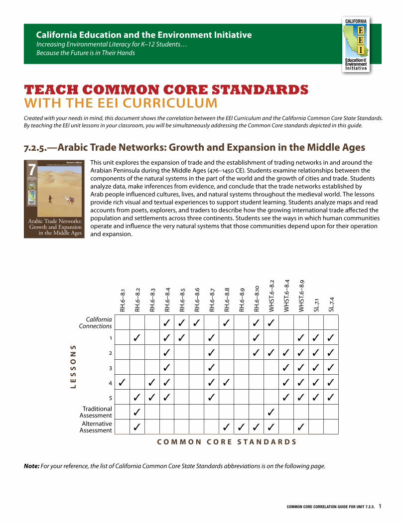
COMMON CORE CORRELATION GUIDE FOR UNIT 7.2.5. 1 RH.6–8.1 RH.6–8.2 RH.6–8.3 RH.6–8.4 RH.6–8.5 RH.6–8.6 RH.6–8.7 RH.6–8.8 RH.6–8.9 RH.6–8.10 WHST.6–8.2 WHST.6–8.4 WHST.6–8.9 SL.7.1 SL.7.4 California Connections ✓ ✓ ✓ ✓ ✓ ✓ LESSONS 1 ✓ ✓ ✓ ✓ ✓ ✓ ✓ ✓ 2 ✓ ✓ ✓ ✓ ✓ ✓ ✓ ✓ 3 ✓ ✓ ✓ ✓ ✓ ✓ 4 ✓ ✓ ✓ ✓ ✓ ✓ ✓ ✓ ✓ 5 ✓ ✓ ✓ ✓ ✓ ✓ ✓ ✓ Traditional Assessment ✓ ✓ Alternative Assessment ✓ ✓ ✓ ✓ ✓ ✓ COMMON CORE STANDARDS Note: For your reference, the list of California Common Core State Standards abbreviations is on the following page. 7.2.5.—Arabic Trade Networks: Growth and Expansion in the Middle Ages This unit explores the expansion of trade and the establishment of trading networks in and around the Arabian Peninsula during the Middle Ages (476–1450 CE). Students examine relationships between the components of the natural systems in the part of the world and the growth of cities and trade. Students analyze data, make inferences from evidence, and conclude that the trade networks established by Arab people influenced cultures, lives, and natural systems throughout the medieval world. The lessons provide rich visual and textual experiences to support student learning. Students analyze maps and read accounts from poets, explorers, and traders to describe how the growing international trade affected the population and settlements across three continents. Students see the ways in which human communities operate and influence the very natural systems that those communities depend upon for their operation and expansion. California Education and the Environment Initiative Teacher’s Edition Arabic Trade Networks: Growth and Expansion in the Middle Ages History-Social Science Standard 7.2.5. 7 California Education and the Environment Initiative Increasing Environmental Literacy for K–12 Students… Because the Future is in Their Hands TEACH COMMON CORE STANDARDS WITH THE EEI CURRICULUM Created with your needs in mind, this document shows the correlation between the EEI Curriculum and the California Common Core State Standards. By teaching the EEI unit lessons in your classroom, you will be simultaneously addressing the Common Core standards depicted in this guide.
Transcript
COMMON CORE CORRELATION GUIDE FOR UNIT 7.2.5. 1
RH.6
–8.1
RH.6
–8.2
RH.6
–8.3
RH.6
–8.4
RH.6
–8.5
RH.6
–8.6
RH.6
–8.7
RH.6
–8.8
RH.6
–8.9
RH.6
–8.10
WH
ST.6
–8.2
WH
ST.6
–8.4
WH
ST.6
–8.9
SL.7.
1
SL.7.
4
California Connections ✓ ✓ ✓ ✓ ✓ ✓
LE
SS
ON
S
1 ✓ ✓ ✓ ✓ ✓ ✓ ✓ ✓
2 ✓ ✓ ✓ ✓ ✓ ✓ ✓ ✓
3 ✓ ✓ ✓ ✓ ✓ ✓
4 ✓ ✓ ✓ ✓ ✓ ✓ ✓ ✓ ✓
5 ✓ ✓ ✓ ✓ ✓ ✓ ✓ ✓Traditional
Assessment ✓ ✓Alternative
Assessment ✓ ✓ ✓ ✓ ✓ ✓
C O M M O N C O R E S T A N D A R D S
Note: For your reference, the list of California Common Core State Standards abbreviations is on the following page.
7.2.5.—Arabic Trade Networks: Growth and Expansion in the Middle AgesThis unit explores the expansion of trade and the establishment of trading networks in and around the Arabian Peninsula during the Middle Ages (476–1450 CE). Students examine relationships between the components of the natural systems in the part of the world and the growth of cities and trade. Students analyze data, make inferences from evidence, and conclude that the trade networks established by Arab people influenced cultures, lives, and natural systems throughout the medieval world. The lessons provide rich visual and textual experiences to support student learning. Students analyze maps and read accounts from poets, explorers, and traders to describe how the growing international trade affected the population and settlements across three continents. Students see the ways in which human communities operate and influence the very natural systems that those communities depend upon for their operation and expansion.
California Education and the Environment InitiativeTeacher’s Edition
Arabic Trade Networks: Growth and Expansion
in the Middle Ages
History-Social Science Standard
7.2.5.
7
California Education and the Environment InitiativeIncreasing Environmental Literacy for K–12 Students… Because the Future is in Their Hands
TEACH COMMON CORE STANDARDS WITH THE EEI CURRICULUMCreated with your needs in mind, this document shows the correlation between the EEI Curriculum and the California Common Core State Standards. By teaching the EEI unit lessons in your classroom, you will be simultaneously addressing the Common Core standards depicted in this guide.
2 COMMON CORE CORRELATION GUIDE FOR UNIT 7.2.5.
Using the EEI-Common Core Correlation Matrix
The matrix on the front page identifies a number of Common Core standards that are supported by this EEI unit. However, the check marks in the matrix do not necessarily signify that the Common Core standards checked will be taught to mastery by using this EEI unit alone. Teachers are encouraged to select which Common Core standards they wish to emphasize, rather than teaching to every indicated standard. By spending more time on selected standards, students will move toward greater Common Core proficiency in comprehension, critical thinking and making reasoned arguments from evidence. Teaching this EEI unit will provide opportunities for teachers to implement the shift in instructional practice necessary for full Common Core implementation.
California Common Core State Standards Abbreviations
■ ■■ CCCSS: California Common Core State Standards
■ ■■ RH: Reading Standards for Literacy in History/Social Studies
■ ■■ SL: Speaking and Listening Standards
■ ■■ WHST: Writing Standards for Literacy in History/Social Studies, Science, and Technical Subjects
Note: Since each Common Core standard includes a breadth of skills, in this correlation, the portion of the standard description that is featured in the Common Core standards applications is cited, using “…” to indicate omitted phrases. For a list of the complete standard descriptions, please see the Common Core Reference Pages located on page 18 of this document.
A Note about Common Core Speaking and Listening StandardsThroughout this unit, students participate in various learning structures and groups to analyze, discuss, and synthesize data, which supports the skill in Speaking and Listening Standard 1 “Participate effectively in a range of collaborative discussions (one-on-one, groups…) with diverse partners.” With prior instruction on collaborative discussions, these various groupings and the materials students examine lend themselves to prime discussion material for collaborative discussions. Learning structures with tasks for pairs and groups are in the following lessons:
■ ■■ Lesson 1: Whole class
■ ■■ Lesson 2: Pairs
■ ■■ Lesson 3: Groups of 8, whole-class sharing of analysis
Students answer 10 multiple-choice questions about information from the unit. Then they answer 5 short-answer questions based on the Afroeurasian trade routes and their influences on trade, Arab population expansion, and the spread of the plague.
RH.6–8.2: Determine the central ideas…of a…source…
WHST.6–8.2b: Develop the topic with relevant, well-chosen facts, definitions, concrete details…or other information and examples.
Alternative Assessment
Students analyze a case study to show what they have learned about Arab trade routes in the Middle Ages and their influence on the world. They write responses to five statements.
RH.6–8.2: Determine the central ideas or information of a…source; provide an accurate summary…
RH.6–8.8: Distinguish among fact, opinion, and reasoned judgment in a text.
RH.6–8.9: Analyze the relationship between a primary and secondary source on the same topic.
RH.6–8.10: …read and comprehend history/social studies texts…independently and proficiently.
WSHT.6–8.2b: Develop the topic with relevant, well-chosen facts, definitions, concrete details…or other information and examples.
WHST.6–8.9: Draw evidence from literary or informational texts to support analysis, reflection, and research.
4 COMMON CORE CORRELATION GUIDE FOR UNIT 7.2.5.
Lesson 1: Networking the Golden State
Students read about the development of the trade and travel “network” linking the communities in California over time. They then use what they know to examine a map of medieval trade routes and commerce centers in and around the Arabian Peninsula.
Arabic Trade Networks: Growth and Expansion in the Middle Ages
32 CALIFORNIA EduCATION ANd THE ENvIRONmENT INITIATIvE I Unit 7.2.5. I Arabic Trade Networks: Growth and Expansion in the Middle Ages CALIFORNIA EduCATION ANd THE ENvIRONmENT INITIATIvE I Unit 7.2.5. I Arabic Trade Networks: Growth and Expansion in the Middle Ages 33
Lesson 1
| Learning Objective
Describe how the growth of human populations and cities led to the establishment of trade routes among Asia, Africa, and Europe to import various goods and products (for example, agricultural products).
Lesson 1
Truck hauling goods on a California highway
Networking the Golden StateThis lesson introduces students to the establishment and evolution of a “network” of
major roads in California, brought about by the need for safe and reliable trade and travel routes by a growing population in the state over time. Students read about the construction of the “Royal Road” (El Camino Real) by Spanish missionaries and the eventual construction of Highway 101 and Interstate 5 on its path. They study a series of maps to analyze ways that commerce and transportation have interacted over the history of the state and consider the settlement patterns along the “network.”
Students then observe a map describing Afroeurasian trade routes and commerce centers during the Middle Ages. They discuss why and how the trade routes used during ancient times, such as the Silk Road, evolved into the complex network they see on the map, and what the effect of such changes might have been on the communities and lands pictured on the map. In subsequent lessons, students explore the evolution
of the Afroeurasian trade network, specifically the role of Arab peoples in its establishment and function.
BackgroundImprovements in agriculture and
industry have played an obvious role in California’s growth, but trade and critical transportation networks have been equally influential. A population map shows that the largest urban areas in the state are concentrated
around its two main highways—Highway 1 or 101, and Interstate 5 (I-5).
California’s natural bays and harbors are areas that have seen considerable growth and development over time. Cities, such as Los Angeles, Long Beach, San Diego, San Francisco, San Jose, Oakland, Sacramento, Stockton, and Eureka, are not only connected to the land-based portion of the state’s trade and travel “network” but are also connected to it by water. The ports in these cities are some of the largest in the world, moving goods into and out of the United States in staggering quantities. As early as 1900, Stockton was a major maritime port, importing and exporting goods into and out of the Central Valley. Steamships carried wheat and onion crops to Sacramento and San Francisco, where they were shipped around the globe. In 1933, the Bay-Delta was dredged to create a deepwater channel 15 feet deep, later increased to 35 feet in the 1960s, to enable larger ships to travel to and from the San Francisco Bay and Stockton.
Agricultural growth, as well as the building of many new highways, caused the trucking industry in the state to grow. Trucks carried goods up and down the north-south high-ways and along east-west routes to shipping and rail centers around the state. Towns grew up around where parts of the “network” crossed over one another. In the San Joaquin
Valley, the town of Los Baños was called “The Crossroads,” when State Highways 33, 152, and 165 all passed through town. Highway 33 ran north from Ventura and ser-viced the growing towns of Maricopa, Avenal, Firebaugh, and Mendota before Interstate 5 was built. Similar changes occurred in the north. East-west running highways 32, 162 and 20 connected agricultural towns on the western side of the Sacramento Valley with U.S. 99. The populations of Orland, Williams, and Willows have increased six to eight times in size since 1900.
Growth along I-5 is an unfolding story. In 1977, virtually nothing built by humans existed between a gas station at the bottom of the Grapevine in Kern County and Stockton. Today, booming stopovers with gas stations,
grocery stores, motels, retail outlets, and restaurants stand adjacent to the freeway in places like Buttonwillow, Kettleman City, Santa Nella, and Patterson. The growth and development of these small towns parallels the way settlements grew in the Arabian Desert.
Growth of settlements and the movement of goods and services between them have had both direct and indirect influences on natural sys-tems within the state. As California’s population grew in the 1900s, more land came under cultivation. People drained wetlands and used a variety of irrigation technologies to move water around. Draining wetlands locally decreases the abundance of native plants and animals. On a large scale, as natural systems change, native spe-cies of plants and animals can decrease or disappear altogether.
Interstate 5 road sign
| Key vocabulary
Export: (verb) To send goods or services to another country for sale. (noun) A product that is sent to another country.
Import: (verb) To bring goods or services in from another country. (noun) A product that is brought from another country.
maritime: Relating to navigation or commerce on the sea.
medieval: Associated with the Middle Ages (476–1450 CE [Common Era]).
Port: A town or city with a harbor where ships can be loaded or unloaded.
Trade: (noun) The exchange of goods by buying, selling, or bartering.
El Camino Real marker bell
National Geographic Resources■ ■■ Afroeurasian Trade Routes student map
■ ■■ Human Geography wall map
■ ■■ Political wall map
Use this correlation in conjunction with the Procedures located on pages 36–37 of the Teacher’s Edition. Only procedure steps with a Common Core correlation are included in the table below.
Student Tasks Common Core Standards Applications
Vocabulary Development: For depth of understanding, vocabulary may be featured within the context of the unit instead of or in addition to the beginning of the lesson.
RH.6–8.4: Determine the meaning of words and phrases as they are used in a text, including vocabulary specific to domains related to history/social studies.
Steps 2 and 3: Students read California Connections: Beyond the “Royal Road” (Student Edition, pages 2–5). Students learn the origins, development, and growth of trade routes in California, and later make a connection between these and the Afroeurasian trade routes. Using visual aids, students contrast and compare the trade routes of California in 1820, 1900, and 1950. Students also make note of the changes in natural resources with increased population, and the effect on life styles of each era.
Suggestion: In addition to providing support for Reading Literacy standards, this selection provides a writing model for the Writing Literacy standards. As students read for content, explicitly point out the text structures the author uses to convey the information.
Suggestion: Refer to the Reading California Connections Using a Common Core Reading and Writing Focus on pages 13–17 to view specific suggestions for integrating Common Core standards while reading this selection not only for content, but for text structure as well.
RH.6–8.2: Determine the central ideas or information of a…source; provide an accurate summary…
RH.6–8.5: Describe how a text presents information (e.g., sequentially, comparatively, causally).
RH.6–8.7: Integrate visual information (e.g., in charts, graphs, photographs, videos, or maps) with other information…
RH.6–8.10: …read and comprehend history/social studies texts…independently and proficiently.
SL.7.1: Engage effectively in a range of collaborative discussions (one-on-one, in groups, and teacher-led) with diverse partners…, building on others’ ideas and expressing their own clearly.
SL.7.4: Present claims and findings…, emphasizing salient points in a focused, coherent manner with pertinent descriptions, facts, details, and examples…
COMMON CORE CORRELATION GUIDE FOR UNIT 7.2.5. 5
Student Tasks Common Core Standards Applications
Step 5: The Growth of Trade (Student Workbook, page 3) assesses students’ achievement of the learning objective: “Describe how the growth of human populations and cities led to the establishment of trade routes in California.” Students independently complete a graphic organizer with ideas generated from class reading and discussion.
Tip: If Student Workbooks need to be reused from year to year, students should not write in them. Some strategies teachers use to preserve the workbooks are:
■ ■■ Have students use binder paper or other lined or unlined paper.
■ ■■ Have students use a sheet protector over the page and write with a whiteboard marker.
■ ■■ Do together as a class on a projector or chart paper.
■ ■■ Project the digital fill-in version and do together as a class.
■ ■■ Students use digital devices to fill in the digital version found on the website.
■ ■■ Make student copies when necessary.
RH.6–8.2: Determine the central ideas…of a…source; provide an accurate summary of the source…
WHST.6–8.9: Draw evidence from literary or informational texts to support analysis, reflection, and research.
6 COMMON CORE CORRELATION GUIDE FOR UNIT 7.2.5.
Lesson 2: Change and Trade in the Arab World
Students examine a physical map of the Arabian Peninsula and then read about ele-ments of life and the beginnings of trade in the area. They answer questions about the natural resources available to the Arab people and the areas where permanent settlements were established.
Arabic Trade Networks: Growth and Expansion in the Middle Ages
46 CALIFORNIA EduCATION ANd THE ENvIRONmENT INITIATIvE I Unit 7.2.5. I Arabic Trade Networks: Growth and Expansion in the Middle Ages CALIFORNIA EduCATION ANd THE ENvIRONmENT INITIATIvE I Unit 7.2.5. I Arabic Trade Networks: Growth and Expansion in the Middle Ages 47
Lesson 2
Lesson 2
Change and Trade in the Arab WorldThis lesson provides students with information about life on the Arabian Peninsula. The
class looks at a physical map of the Arabian Peninsula and makes a list of the unique land and water features of this area of the world. Students review what they know about the influence of geography and climate on human settlement patterns. They then read about how trade and innovation helped Arab people make more efficient use of the resources on the peninsula, increasing the supply of resources, which then contributed to the rise of permanent settlements in what was once a largely nomadic culture.
BackgroundTwo distinct geographic and
climatic zones mark the Arabian Peninsula, the desert interior, and the mountainous coasts of the penin-sula. The majority of the interior of the Arabian Peninsula, below verdant Mesopotamia, is largely inhospitable. Arabs living there were ethnically one people, but comprised two culturally distinct groups: nomadic and sed-entary tribes. The nomads, known as Bedouins, lived in small family groups and moved their herds, seek-ing scarce resources and water. Highly territorial, these tribes claimed and defended oases for their own use. They also carried trade goods in their caravans or escorted merchants who were carrying such goods.
Non-Bedouin Arabs fell into two groups. The first settled in oases in the interior. Since water was readily available in the oases, a limited
agricultural surplus soon allowed this group to trade foods, along with craft wares, with the Bedouins. Over time, water-lifting technologies and tools brought to the oasis settlements via Persian, Egyptian, and Roman traders made farming easier and increased production. Greater production, in turn, created surpluses that enabled more trade; families were able to grow. In addition, continued contact with the outside world introduced new crops to these settlements.
The second group of non-Bedouin Arabs settled in the coastal areas along the Red Sea. This area’s mountains and steppes have an accessible aquifer that permitted irrigation. Arabs here built numerous earthen dams and complex irrigation systems; they soon boasted surpluses in their settlements. Surplus agricultural goods provided a means for villagers to trade with cara-vans passing through the Hejaz. These
settlements soon became part of the overland trade routes con-necting Africa and India with one another and with civilizations around the Mediterranean.
Western and Southern Arabia’s settlements grew into a number of powerful kingdoms over time. This area receives monsoonal rainfall that can support agriculture. The most famous of these kingdoms were Sa’ba (often referred to as Sheba) and Aden, which became the most famous port city in Arabia. These kingdoms became centers of the maritime trading net-work that connected the East and West.
Camel caravan
Students return to their maps showing the Afroeurasian Trade Routes in the Middle Ages and identify which permanent settlements evolved into centers of commerce and trade in the
Arabian Peninsula. They conclude that settlements near oases and on strategic coastal sites became increasingly important to the Arab culture as trade during the Middle Ages grew. In the next lesson, they
explore the involvement of these settlements as they became part of a worldwide commercial network and learn about some of the popular goods and products that were transported through them. Bedouin camp in the Sahara Desert, Morocco
| Key vocabulary
Afroeurasia: The continents of Africa, Europe, and Asia.
Caravan: A group of travelers, such as merchants or pilgrims, who travel together.
Climate: The prevailing, average weather conditions of a particular area over time.
Natural resources: Materials, such as water, minerals, energy, and soil, that people use from nature and natural systems.
Nomad: A member of a tribal people with no permanent home, who travels to find food, pasture, and water for livestock.
Oasis: A fertile area in a desert where there is a supply of water.
Surplus: The quantity of goods or services above the quantity needed to meet one’s own needs.
Topography: The surface features of an area or the use of symbols and colors on a map to show surface features of an area.
| Learning Objective
Describe how improvements to agricultural practices on the Arabian Peninsula increased supplies of food and other agricultural products (sometimes creating surpluses), which led to the growth of trade.
National Geographic Resources■ ■■ Afroeurasian Trade Routes student map
Use this correlation in conjunction with the Procedures located on pages 50–51 of the Teacher’s Edition. Only procedure steps with a Common Core correlation are included in the table below.
Student Tasks Common Core Standards Applications
Vocabulary Development: For depth of understanding, vocabulary may be featured within the context of the unit instead of or in addition to the beginning of the lesson.
RH.6–8.4: Determine the meaning of words and phrases as they are used in a text, including vocabulary specific to domains related to history/social studies.
Step 1: Students engage in teacher-led discussion based on the Physical Map of the Arabian Peninsula (Visual Aid #4) to determine that water was the factor that had the biggest influence on how people lived in Arabia.
RH.6–8.7: Integrate visual information (e.g., in charts, graphs, photographs, videos, or maps) with other information…
SL.7.1: Engage effectively in a range of collaborative discussions (one-on-one, in groups, and teacher-led) with diverse partners…, building on others’ ideas and expressing their own clearly.
SL.7.4: Present claims and findings…, emphasizing salient points in a focused, coherent manner with pertinent descriptions, facts, details, and examples…
Steps 2–4: Students (in pairs) read Life and Trade on the Arabian Peninsula (Student Edition, pages 6–9) as they use their Afroeurasian Trade Routes in the Middle Ages student map to locate the places and trace the routes mentioned in the reading.
Suggestion: In addition to providing support for Reading Literacy standards, this selection provides a writing model for the Writing Literacy standards. As students read for content, explicitly point out the text structures the author uses to convey the information.
RH.6–8.7: Integrate visual information (e.g., in charts, graphs, photographs, videos, or maps) with other information…
RH.6–8.10: …read and comprehend history/social studies texts…independently and proficiently.
SL.7.1: Engage effectively in a range of collaborative discussions (one-on-one, in groups, and teacher-led) with diverse partners…, building on others’ ideas and expressing their own clearly.
COMMON CORE CORRELATION GUIDE FOR UNIT 7.2.5. 7
Student Tasks Common Core Standards Applications
Step 5: Students (in pairs) discuss and answer five short-answer questions in Change in Arabia (Student Workbook, pages 4–6) to determine achievement of the learning objective: “Describe how the natural resources available to the Arab people and the areas where permanent settlements were established led to the trade routes.” Students reread Life and Trade on the Arabian Peninsula (Student Edition, pages 6–9) and use the visual aid Afroeurasian Trade Routes in the Middle Ages to discuss and answer the questions.
RH.6–8.7: Integrate visual information (e.g., in charts, graphs, photographs, videos, or maps) with other information…
SL.7.1: Engage effectively in a range of collaborative discussions (one-on-one, in groups, and teacher-led) with diverse partners…, building on others’ ideas and expressing their own clearly.
WHST.6–8.2: Write informative/explanatory texts…
b) Develop the topic with relevant, well-chosen facts, definitions, concrete details…or other information and examples.
d) Use precise language and domain-specific vocabulary to inform about or explain the topic.
WHST.6–8.4: Produce clear and coherent writing in which the development, organization, and style are appropriate to task, purpose, and audience.
WHST.6–8.9: Draw evidence from literary or informational texts to support analysis, reflection, and research.
8 COMMON CORE CORRELATION GUIDE FOR UNIT 7.2.5.
Lesson 3: What Traveled on the Trade Routes
Students analyze photographs of products transported across Afroeurasian trade routes and use resources to describe them. They identify their origin, the source of the materials of which they were made, their possible use, and the routes across which they were transported.
Arabic Trade Networks: Growth and Expansion in the Middle Ages
62 CALIFORNIA EduCATION ANd THE ENvIRONmENT INITIATIvE I Unit 7.2.5. I Arabic Trade Networks: Growth and Expansion in the Middle Ages CALIFORNIA EduCATION ANd THE ENvIRONmENT INITIATIvE I Unit 7.2.5. I Arabic Trade Networks: Growth and Expansion in the Middle Ages 63
Lesson 3
| Learning Objective
Provide examples of the goods, products, and inventions that were transported along these routes (for example, spices, textiles, paper, steel, new crops).
continued well into the sixteenth century. The crews aboard Arab dhows, with their knowledge of the climatic conditions, crisscrossed the Indian Ocean to exchange goods with China, Malaysia, India, and East Africa. Overland caravans connected this maritime trade with commercial networks in Egypt, Rome, Byzantium, Persia, and the kingdoms of Europe, bringing spices and textiles from the East.
Following Muhammad’s death in 632 CE, Islamic forces from kingdoms
in the Arabian Peninsula quickly conquered the disintegrating ancient empires surrounding it. Byzantium held ground north of the Black Sea, but everything between the Euphrates River and North Africa fell under Islamic control. These conquests continued for another 200 years before leveling off. The Umayyad and Abbasid Dynasties established an Islamic capital in Damascus (later moved to Baghdad) for an empire that stretched west to Andalus (Spain) and east to Samarkand (Uzbekistan).
The new Islamic empire took control of the commer-cial networks of the ancient world, uniting them under a single banner. Improved security along trade routes increased commercial traffic through all of Afroeurasia. Increased trade, in turn, resulted in population growth. The Abbasids founded Baghdad in 763; a significant percentage of all trade moving east and west from Europe to China passed through the city. By 1028, more than 75,000 people lived there. Precise population figures are difficult to calculate, but when the Mongols sacked Baghdad in 1258, it was home to approximately one million people.
Baghdad was not the only commercial center of the pre-1300 Islamic empire. Kairouan, built in 670, became the capital of the rebellious Aghlabid Caliphate in 800, and soon controlled the Mediterranean’s olive and horse trade. Tunis, originally built as a launching point to invade Sicily and Sardinia, quickly became the port of trade between Europe and North Africa. In 969, the Fatamid Caliphate conquered and built a new capital city on the Nile to control the trade routes along the river. The new city was named Cairo.
| Key vocabulary
dhow: An Arab, single-masted, sailing ship rigged with one or two lateen (triangular) sails.
Foodstuff: An item that is consumed as food.
Spices: Aromatic plant materials used for flavoring food or creating a pleasant odor.
Textiles: A cloth or woven fabric.
Arab dhow at sunset
Lesson 3
What Traveled on the Trade RoutesImagining themselves as archaeologists, students use a series of “artifacts” from a 14th‑century
Arab dhow “found” submerged near the East African trading port of Kilwa to help them identify and describe goods and products exchanged over Afroeurasian trade routes in the Middle Ages.
Unearthing ancient artifacts
They look closely at details of each “artifact” to determine information about its origin, composition, and connections to people and places. Students complete their analysis using a product key that enables them to match the products to a probable point of origin and then to consider
all the elements of commercial activity that might have brought each item to Africa.
In completing this lesson, students give examples of key products trans-ported across the trade routes linking Europe, Africa, and Asia. This lesson prepares students to explore the
changes to the cities along these trade routes as they were influenced by the people and goods passing through them.
BackgroundCommercial activity in pre-Islamic
Arabia established trade patterns that
Use this correlation in conjunction with the Procedures located on page 66 of the Teacher’s Edition. Only procedure steps with a Common Core correlation are included in the table below.
Student Tasks Common Core Standards Applications
Vocabulary Development: For depth of understanding, vocabulary may be featured within the context of the unit instead of or in addition to the beginning of the lesson.
RH.6–8.4: Determine the meaning of words and phrases as they are used in a text, including vocabulary specific to domains related to history/social studies.
Step 1: Students are led through an overview of the lesson. Review Afroeurasian Trade Routes in the Middle Ages (Visual Aid #5), locating the city Kilwa on the map. Describe the archaeological retrieval of cargo from a 14th or 15th century dhow near the city of Kilwa. Project Artifacts From the Sunken Dhow (Information Cards #1–8).
SL.7.1: Engage effectively in a range of collaborative discussions (one-on-one, in groups, and teacher-led) with diverse partners…, building on others’ ideas and expressing their own clearly.
Steps 2–5: In groups of eight, have students turn to Goods and Products Key (Students Edition, pages 10–11) and to Product Analysis Notes (Student Workbook, pages 7–8). Provide students a set of Artifacts From the Sunken Dhow (Information Cards #1–8) to analyze and help complete questions.
Students will then share his or her group analysis with the class while tracing the route each product was traveling when the dhow sank.
RH.6–8.7: Integrate visual information (e.g., in charts, graphs, photographs, videos, or maps) with other information…
SL.7.1: Engage effectively in a range of collaborative discussions (one-on-one, in groups, and teacher-led) with diverse partners…, building on others’ ideas and expressing their own clearly.
SL.7.4: Present claims and findings…, emphasizing salient points in a focused, coherent manner with pertinent descriptions, facts, details, and examples…
WHST.6–8.4: Produce clear and coherent writing in which the development, organization, and style are appropriate to task, purpose, and audience.
WHST.6–8.9: Draw evidence from literary or informational texts to support analysis, reflection, and research.
COMMON CORE CORRELATION GUIDE FOR UNIT 7.2.5. 9
Lesson 4: They Saw It with Their Own Eyes
In pairs, students read and interpret a journal account describing a flourishing commercial center in the Middle Ages, as seen by an Arab traveler. They answer questions about the influence of Arab culture on these cities and examine census data from key locations along the trade routes during the late medieval period.
Arabic Trade Networks: Growth and Expansion in the Middle Ages
80 CALIFORNIA EduCATION ANd THE ENvIRONmENT INITIATIvE I Unit 7.2.5. I Arabic Trade Networks: Growth and Expansion in the Middle Ages CALIFORNIA EduCATION ANd THE ENvIRONmENT INITIATIvE I Unit 7.2.5. I Arabic Trade Networks: Growth and Expansion in the Middle Ages 81
Lesson 4
the economic hubs of the Arab world. These two cities straddled the con-tinents of Asia, Africa, and Europe. All goods traded and most travelers went through those two cities at one time or another. Merchants con-trolled the trade of raw materials and finished products in smaller markets located ever more distant from the Arabian Peninsula: Kairouan, Tunis,
and Fez in North Africa; Córdoba, Granada, and Málaga in Spain; Kilwa, Mombassa, and Mogadishu in East Africa; Male, and Malacca in Southeast Asia; and Tabriz, Bukhara, and Sarai in the Eurasian steppe.
Arab society greatly influenced many of the non-Arab peoples it con-quered. The further east one traveled, the less evidence one saw of Arab
culture unless one visited an Arab inn that accommodated caravans (caravansary), an Arab bazaar, or the living-quarters that housed Arab merchants. But in south-ern Spain, North Africa, the Levant, the steppe north of the Black Sea, and Swahili villages of Africa, Arab influ-ence was (and is) quite strong.
Travel was common within the Arab tradition. Not all Arab people were (or are) Muslim, but for those of the Islamic faith, travel was (is) part of their lives. All Muslims were (are), for religious reasons, expected to make a pilgrimage (hajj) to Mecca if they could afford to do so. Many merchants took the opportunity to attend to commercial matters while on their hajj, conducting business made safe by Islamic control of the areas through which they traveled. Muslims traveled with relative safety in areas controlled by non-Muslims if they traveled in any of the well-armed Islamic caravans that plied the region. A commonality of language, religion, and coinage among Arab peoples and their abilities to move goods and products around the world contrib-uted to the influence of Arab culture along the trade routes. Back on the Arabian Peninsula, Arab peoples prospered and flourished due to this economic success.
People on pilgrimage to Mecca
| Key vocabulary
Bazaar: A permanent market or street of shops and stalls.
dirham: An Arab coin.
mosque: A building where believers in Islam go to worship.
Sultan: The Arabic name for the ruler of a country or place.
| Learning Objective
Describe how towns were settled along well-known trade routes, thus allowing Arab society to take advantage of raw materials from locations that were even more distant from the region.
Lesson 4
They Saw It with Their Own EyesWorking with primary source descriptions of popular Arab trading centers during the
Middle Ages, students identify the influence that the increase of trade, the variety of products, and the growing power and influence of Arab culture had on locations far from the Arabian Peninsula and on the peninsula itself. They describe raw materials and finished products mentioned in the accounts and identify the influence that these materials and the business of trading them had on these cities.
Market in Marrakesh
The primary sources used are excerpts from actual travelers’ accounts, valuable sources of information about the Arab world in the Middle Ages. Students locate the Arab towns described in the accounts on the map of Afroeurasian Trade Routes in the Middle Ages. They
describe raw materials and identify the influence that these materials and the business of trading them had on these cities.
During this lesson, students conclude that Arab peoples built and settled towns along well-known trade routes. They recognize that
this settlement pattern enabled Arab society to take advantage of raw materials and innovations from distant lands.
BackgroundBaghdad and Cairo not only served
as dynastic capitals but also acted as
Use this correlation in conjunction with the Procedures located on pages 84–85 of the Teacher’s Edition. Only procedure steps with a Common Core correlation are included in the table below.
Student Tasks Common Core Standards Applications
Vocabulary Development: For depth of understanding, vocabulary may be featured within the context of the unit instead of or in addition to the beginning of the lesson.
RH.6–8.4: Determine the meaning of words and phrases as they are used in a text, including vocabulary specific to domains related to history/social studies.
Step 1: Preview the lesson by covering the changes caused by living things in the environment in which they live, noting that some of these changes are detrimental and some are beneficial. Project Afroeurasian Trade Routes in the Middle Ages (Visual Aid #5) with the cities of Mecca, Baghdad, and Cairo identified. Discuss why these three cities were the biggest centers of trade in the world, and under Arab control.
SL.7.1: Engage effectively in a range of collaborative discussions (one-on-one, in groups, and teacher-led) with diverse partners…, building on others’ ideas and expressing their own clearly.
SL.7.4: Present claims and findings…, emphasizing salient points in a focused, coherent manner with pertinent descriptions, facts, details, and examples…
10 COMMON CORE CORRELATION GUIDE FOR UNIT 7.2.5.
Student Tasks Common Core Standards Applications
Steps 2–4: Using primary source materials Nasir Khusraw’s Account of Tripoli (Student Edition, page 12), Ibn Battuta’s Account of Sarai (Student Edition, page 13), or Ibn Battuta’s Account of Malaga (Student Edition, page 14) and Afroeurasian Trade Routes in the Middle Ages (Visual Aid #5) students will work in pairs to answer questions on Journal Account Study Guide (Student Workbook, page 9).
Students share out to the whole group the name of the place in their account and something interesting they learned about the place through the account. Students add to their individual notes as other students share. The teacher points out the particular city as each student shares.
RH.6–8.1: Cite specific textual evidence to support analysis of primary and secondary sources.
RH.6–8.3: Identify key steps in a text’s description of a process related to history/social studies (e.g., how a bill becomes law, how interest rates are raised or lowered).
RH.6–8.7: Integrate visual information (e.g., in charts, graphs, photographs, videos, or maps) with other information…
RH.6–8.8: Distinguish among fact, opinion, and reasoned judgment in a text.
SL.7.1: Engage effectively in a range of collaborative discussions (one-on-one, in groups, and teacher-led) with diverse partners…, building on others’ ideas and expressing their own clearly.
SL.7.4: Present claims and findings…, emphasizing salient points in a focused, coherent manner with pertinent descriptions, facts, details, and examples…
WHST.6–8.4: Produce clear and coherent writing in which the development, organization, and style are appropriate to task, purpose, and audience.
WHST.6–8.9: Draw evidence from literary or informational texts to support analysis, reflection, and research.
Step 5: Introduce the concept of “census.” Project Population Data for Arab Cities in the Middle Ages (Visual Aid #6). Students analyze the data and its significance.
RH.6–8.4: Determine the meaning of words and phrases as they are used in a text, including vocabulary specific to domains related to history/social studies.
SL.7.1: Engage effectively in a range of collaborative discussions (one-on-one, in groups, and teacher-led) with diverse partners…, building on others’ ideas and expressing their own clearly.
SL.7.4: Present claims and findings…, emphasizing salient points in a focused, coherent manner with pertinent descriptions, facts, details, and examples…
COMMON CORE CORRELATION GUIDE FOR UNIT 7.2.5. 11
Lesson 5: The Silent Traveler
Students review what they have learned about human adaptation to natural systems on the Arab trade routes. They read about how the plague spread along the trade routes in the 1300s, and complete a graphic organizer that shows they understand the causes, transmission, and consequences of the plague.
Arabic Trade Networks: Growth and Expansion in the Middle Ages
92 CALIFORNIA EduCATION ANd THE ENvIRONmENT INITIATIvE I Unit 7.2.5. I Arabic Trade Networks: Growth and Expansion in the Middle Ages CALIFORNIA EduCATION ANd THE ENvIRONmENT INITIATIvE I Unit 7.2.5. I Arabic Trade Networks: Growth and Expansion in the Middle Ages 93
Lesson 5
Asia to Europe to Africa. In the center of it all lay the Arabian Peninsula, which became a crossroads in this complex, wide-ranging Afroeurasian trade system. Along overland and maritime routes, traders transported goods to places where people wanted them. In exchange, they took with them goods that were wanted in their places of origin.
As goods traveled these land and sea routes, so too did ideas and beliefs. Islam spread across much of the region that comprised Afroeurasian trade routes in the Middle Ages, and with it technology, scientific and mathematical knowl-edge, and language.
But trade sometimes changed life in unexpected and unwanted ways. The bubonic plague of the 1300s is believed to have originated in China, then spread south to India, west across Asia and eastern Europe, to Arabia and the Middle East, and on to western Europe. In a few short years, the disease had decimated the population of this vast area of Earth. According to most estimates, one-third of the human population died during the plague.
The effects of this huge population decline rippled into every area of life throughout the vast trading zone. In Europe and in the Middle East (the best records exist for Egypt), social, political, and economic relations changed. With fewer people, workers demanded more money for their
efforts. Prices for food and other products rose accordingly. Many of those who worked others’ land were able to claim land of their own. European producers and merchants sometimes benefited at the expense of the Arab world, as innovative technol-ogies lowered the price and improved the quality of European textiles, while Alexandria’s cloth factory, for example, was nearly destroyed by plague-related
deaths. At the same time, Chinese ceramics outsold Middle Eastern ceramics because they were cheaper and of higher quality. And the changes continued, as bouts of plague recurred at regular intervals over the next 200 years.
N O R T H AT L A N T I C
O C E A N
B L A C KS E A
NORTHSEA
BALTICSEA
MEDITERRANEAN SEA
BARENTSSEA
London
RouenParis
Toledo
Barcelona
Marseilles
BrugesFrankfurt
Brunswick
Lubeck
Copenhagen
Warsaw
Milan
RavennaFlorence
Rome
Prague
Vienna
Thessaloniki
Athens
Bucharest
Magdeburg
1347
Mid 1348
Early 1349
Late 1349
1350
1351
After 1351
Minor Outbreak
City of Orientation
Center of Uprisings
0 250 500
Miles
125
Spread of bubonic plague in Europe
| Key vocabulary
Pandemic: An epidemic disease that spreads across many countries and affects large numbers of people.
Plague: A contagious epidemic disease, such as the bubonic plague.
Sedentary: Remaining in one location and not migrating.
| Learning Objective
Provide examples of the direct and indirect influences of trade routes on the natural systems that were the sources of the goods and products that were being transported.
Lesson 5
Aftermath of the plague
The Silent TravelerIn this concluding lesson, students review the relationship between natural systems and
human systems. They review what they have learned about Afroeurasian trade in the Middle Ages—the conditions that made trade possible, the routes along which trade occurred, and the effects that trade had on people’s lives. They use this as background to explore a different kind of “traveler” along the trade routes: the plague.
Students begin the lesson by completing a table that shows they have understood how humans adapted to and altered natural systems in settling the Arabian Peninsula. Then, as a class, they read about the plague, including its causes, its transmission
routes, and its consequences. They participate in an in-class activity that demonstrates the extent of the plague’s reach. As a concluding activity, they complete a graphic organizer that shows they have understood the causes and consequences of the
pandemic that ravaged Europe, Asia, and Northern Africa in the 1300s.
BackgroundTrade affected virtually every
aspect of life in the Middle Ages. A vast trade network stretched from
Use this correlation in conjunction with the Procedures located on pages 96–97 of the Teacher’s Edition. Only procedure steps with a Common Core correlation are included in the table below.
Student Tasks Common Core Standards Applications
Vocabulary Development: For depth of understanding, vocabulary may be featured within the context of the unit instead of or in addition to the beginning of the lesson.
RH.6–8.4: Determine the meaning of words and phrases as they are used in a text including vocabulary specific to domains related to history/social studies.
Step 1: Students conduct a lesson review covering trade networks in the Middle Ages using Natural Systems and Human Systems on the Arabian Peninsula: A Review (Student Workbook, page 10) and Natural Systems and Human Systems: A Review (Visual Aid #7).
RH.6–8.2: Determine the central ideas or information of a…source; provide an accurate summary…
SL.7.1: Engage effectively in a range of collaborative discussions (one-on-one, in groups, and teacher-led) with diverse partners…, building on others’ ideas and expressing their own clearly.
SL.7.4: Present claims and findings…, emphasizing salient points in a focused, coherent manner with pertinent descriptions, facts, details, and examples…
WHST.6–8.4: Produce clear and coherent writing in which the development, organization, and style are appropriate to task, purpose, and audience.
WHST.6–8.9: Draw evidence from literary or informational texts to support analysis, reflection, and research.
Steps 2–4: Students read The Silent Traveler (Student Edition, pages 15–16) aloud as a class.
Project The Spread of the Plague (Visual Aid #8) Students learn that the plague traveled along Afroeurasian trade routes and killed about one-third of the population in Arabia, Europe, and parts of Asia and North Africa.
Project Population Data for Arab Cities in the Middle Ages (Visual Aid #6) for students to see the correlation in population dips and the presence of the plague.
Students complete a cause-and-effect diagram in Causes and Effects of the Plague (Student Workbook, page 11) to assess what they have learned.
RH.6–8.2: Determine the central ideas or information of a…source; provide an accurate summary…
RH.6–8.3: Identify key steps in a text’s description of a process related to history/social studies (e.g., how a bill becomes law, how interest rates are raised or lowered).
RH.6–8.7: Integrate visual information (e.g., in charts, graphs, photographs, videos, or maps) with other information…
12 COMMON CORE CORRELATION GUIDE FOR UNIT 7.2.5.
Student Tasks Common Core Standards Applications
Steps 2–4 (Continued): SL.7.1: Engage effectively in a range of collaborative discussions (one-on-one, in groups, and teacher-led) with diverse partners…, building on others’ ideas and expressing their own clearly.
WHST.6–8.4: Produce clear and coherent writing in which the development, organization, and style are appropriate to task, purpose, and audience.
WHST.6–8.9: Draw evidence from literary or informational texts to support analysis, reflection, and research.
Unit AssessmentRefer to the introduction pages at the front of this document for information regarding the Traditional and Alternative Assessments for this unit and their Common Core correlations.
COMMON CORE CORRELATION GUIDE FOR UNIT 7.2.5. 13
California Connections and Common Core
Reading California Connections using a Common Core Reading and Writing Focus
Reading
History teachers can further enhance the teaching of Common Core Reading Literacy Standards by noting the suggestions below and in the following pages while reading the California Connections selection for content. Explicitly teach students to pay attention to the structure of the text by noting the following:
■ ■■ Note how the author cites evidence to support main points and analysis. (RH.6–8.1)
■ ■■ Note how the author sets up the central ideas or information; and provide an accurate summary of the text distinct from prior knowledge or opinions. (RH.6–8.2)
■ ■■ Identify key steps in a text’s description of a process related to history. (RH.6–8.3)
■ ■■ Note how the author explains the meaning of key words, phrases, and vocabulary related to history/social studies. (RH.6–8.4)
■ ■■ Analyze the structure the author uses to organize the text; describe how a text presents information (e.g., sequentially, comparatively, causally). (RH.6–8.5)
■ ■■ Analyze the author’s point of view and purpose, including watching for loaded language and inclusion or avoidance of particular facts. (RH.6–8.6)
■ ■■ Note how the information in the California Connections text integrates with information provided throughout the unit in diverse formats, including charts, graphs, photographs, videos, or maps. (RH.6–8.7)
■ ■■ Distinguish among fact, opinion, and reasoned judgment in a text. (RH.6–8.8)
■ ■■ Analyze the relationship between a primary and secondary source on the same topic. (RH.6–8.9)
■ ■■ Note comprehension strategies for understanding text. (RH.6–8.10)
Note: Standard descriptions from the Reading Standards for Literacy in History/Social Studies are paraphrased and combined, using terminology that applies to reading a California Connections selection.)
WritingMany California Connections selections can be used as a model for future student writing tasks applying the Writing Literacy Standards by noting how the author structures the text, organizes the ideas, and provides well-chosen relevant and sufficient facts, extended definitions, concrete details, quotations, or other information and examples.
Using the California Connections SelectionThe following pages note specific places where the California Connections selection provides examples for specific Writing Literacy Standards, using this selection as a writing model. They also provide suggestions for teaching students to analyze text structure using the Reading Literacy Standards. Teachers can incorporate more suggestions from the list above.
14 COMMON CORE CORRELATION GUIDE FOR UNIT 7.2.5.
California Connections and Common Core
2 CALIFORNIA EDUCATION AND THE ENVIRONMENT INITIATIVE I Unit 7.2.5. I Arabic Trade Networks: Growth and Expansion in the Middle Ages I Student Edition
California Connections: Beyond the “Royal Road”
Lesson 1 | page 1 of 4
Beyond the “Royal Road”
Wheat field
Even though he lives in Tijuana, Mexico, Roberto works in San Diego. He crosses the international border at San Ysidro, the busiest border crossing in the Western Hemisphere. On some days, he may wait in the line of traffic for
At 7:00 a.m., Roberto Ruiz sits patiently in his car as he does every weekday
morning. He looks out over the long lines of cars, vans, and trucks all around
him waiting to cross the border from Mexico to the United States. People
traveling on foot gather alongside the road, laughing and chatting.
more than an hour. When Roberto finally moves past the border officials, he is happy to see the straight lanes of Interstate 5 (I-5) stretching out before him. He puts his foot on the gas and picks up speed, hoping that he will not be late for work.
Roberto will only be traveling on I-5 to and from work today. He knows, however, that this highway stretches all the way to the Canadian border. It is 1,381 miles long and connects many important cities and the capitals of California, Oregon, and Washington along its length.
Following Old PathsInterstate 5 follows the
same paths used by people long before there were countries and the borders between them in this part of the world. American Indians first forged these paths to look for game and to gather food in different seasons. Then, in 1769, a few settlers and Catholic padres arrived from Spain and Mexico. They built presidios (forts) and missions in central and Southern California. The
RH.6–8.5: Describe how a text presents information…
■ ■■ Narrative
Suggestion: Point out to students that while this is informational text it is written in narrative style.
RH.6–8.8: Distinguish among fact, opinion, and reasoned judgment in a text.
RH.6–8.10: …read and comprehend history/social studies text…independently and proficiently.
Suggestion: Have students analyze how the author switches between a narrative and explaining details about Interstate 5.
COMMON CORE CORRELATION GUIDE FOR UNIT 7.2.5. 15
California Connections and Common Core
CALIFORNIA EDUCATION AND THE ENVIRONMENT INITIATIVE I Unit 7.2.5. I Arabic Trade Networks: Growth and Expansion in the Middle Ages I Student Edition 3
California Connections: Beyond the “Royal Road”
Lesson 1 | page 2 of 4
padres and soldiers traveled along a narrow footpath from mission to mission and from fort to fort. They carried supplies and news. The path started in Baja California Sur (Mexico), where the first two missions were built. They named the path El Camino Real, which means “The Royal Road” or “King’s Road.”
Where El Camino Real ended, other paths continued north. Hunters and trappers traveled from the Central Valley in California to Oregon on an ancient route called the Siskiyou Trail. The trail climbed up one side of Mt. Shasta. Then it wound down the steep mountain to the valley below. In 1837, Ewing Young drove 700 cattle north over this trail. He delivered the cattle to families who had recently settled in Oregon. A few years later during the Gold Rush, many more people would use this trail to come south and seek their fortunes in California.
By the 1860s, people were traveling El Camino Real and the Siskiyou Trail by wagon and stagecoach. The paths had become trenched and pitted with holes. Roads were graded and holes filled.
People could move freely from one end of the state to the other. It took another 50 years, however, for people to begin paving these roads. It was not until 1912, that the first section of El Camino Real was paved. It became one of California’s first state highways.
Paving New RoadsIn 1915, the Pacific Highway
was dedicated. (“Pacific” means peaceful.) The new automobile route stretched from Canada to Mexico over parts of the Siskiyou Trail and El Camino Real. Travel on the Pacific Highway, however,
was a wild adventure because most of the road was rough and difficult to drive on. As automobile travel and trade increased between California, Oregon, Washington, Canada, and Mexico, the U.S. federal government stepped in. They helped create a system of numbered “interstate highways” to help people and goods travel more quickly and safely. Signs on these roads would all be the same, even as they crossed state lines (but not international borders).
U.S. Route 101 (Highway 101) was one of the first major routes to be commissioned. It
I-5 in California
RH.6–8.5: Describe how a text presents information…(sequentially…).
RH.6–8.4: Determine the meaning of words…
■ ■■ Padres
■ ■■ El Camino Real
16 COMMON CORE CORRELATION GUIDE FOR UNIT 7.2.5.
California Connections and Common Core
4 CALIFORNIA EDUCATION AND THE ENVIRONMENT INITIATIVE I Unit 7.2.5. I Arabic Trade Networks: Growth and Expansion in the Middle Ages I Student Edition
California Connections: Beyond the “Royal Road”
Lesson 1 | page 3 of 4
was built on much of the old Pacific Highway. But it ended before reaching the Canadian border. Highway 101 is the most western route in the U.S. highway system. In the past, it was a major artery for commerce moving up and down the coast. It is still a favorite route for those traveling to San Francisco and the northern coasts of California, Oregon, and Washington.
Another highway that was part of the federal plan was Highway 99. “Route 99” ran like a backbone through Central California. The highway began at the Mexican border. It followed El Camino Real as it passed through San Diego and through the L.A. basin. The road climbed over the Ridge Route and passed through the town of Bakersfield.
Leaving the Central Valley, the highway closely followed the old Siskiyou Trail to the border of the U.S. and Canada. Highway 99 carried most of the agricultural and industrial goods produced in California to other places over three decades.
Constructing a SystemAll interstate highways
became part of the National Highway System in 1956. Roads under this system had to meet certain government standards: They had to connect to major cities and industrial centers. They had to follow the most direct route(s) from one city to the next. In case of disaster, they had to provide safe and efficient escape routes. They had to allow for the safe transport of military troops and equipment. And, (if possible) they had to provide crossing points for travelers and goods going into and coming from other countries (Canada and Mexico). From this system came the road we know today as Interstate 5.
Interstate 5 is the major north-south interstate highway on the West Coast. I-5 was built on top of much of the
Peace Arch at the I-5 U.S.A./Canada border
RH.6–8.8: Distinguish among fact, opinion, and reasoned judgment in a text.
RH.6–8.5: Describe how a text presents information…
■ ■■ cause and effect
COMMON CORE CORRELATION GUIDE FOR UNIT 7.2.5. 17
California Connections and Common Core
CALIFORNIA EDUCATION AND THE ENVIRONMENT INITIATIVE I Unit 7.2.5. I Arabic Trade Networks: Growth and Expansion in the Middle Ages I Student Edition 5
California Connections: Beyond the “Royal Road”
Lesson 1 | page 4 of 4
old Highway 99 through the Central Valley. From Mexico, through San Diego to Anaheim, it follows the original route of El Camino Real. From the Central Valley to the border of Canada, I-5 follows the old Siskiyou Trail.
Most of the goods that Californians use and make travel along I-5. It is the major artery carrying agricultural products to the cities outside of the state and to shipping centers in Stockton and Sacramento. Tourists use
Bags of cement ready for shipping
the interstate to reach their vacation destinations quickly and safely. Daily commuters, like Roberto Ruiz, drive from their homes to work using I-5. Around 299,000 people travel some distance on Interstate 5 each day. Each year, around 300 million people cross the international borders into Canada and Mexico, via I-5.
At 7:00 p.m., Roberto Ruiz is glad to be driving home after work. As he leaves San Diego, the Sun is setting. It
will soon be dark. The traffic on Interstate 5 begins to back up before he reaches San Ysidro. Though he has waited until 7 in the evening, there are still people waiting to cross the border into Mexico. Roberto eases back into the seat of his car. He has heard that the border crossing will be expanded this year. More check points and lanes will be built to handle the travelers and trade crossing the border each day. Until then, he will just have to wait in line.
RH.6–8.6: Identify aspects of a text that reveal an author’s point of view or purpose…
Suggestion: Throughout the article, analyze the reasons the author presents the information in this way, and why certain facts are included.
RH.6–8.5: Describe how a text presents information…
Suggestion: Review the text, noting how overall, the information is mostly presented sequentially, with cause-and-effect and narrative embedded.
WHST.6–8.2f: Provide a concluding statement…
Suggestion: Discuss how the conclusion connects with the beginning of the article.
18 COMMON CORE CORRELATION GUIDE FOR UNIT 7.2.5.
California Common Core State Standards Descriptions
Reading Standards for Literacy in History/Social Studies■ ■■ RH.6–8.1: Cite specific textual evidence to support analysis of primary and secondary sources.
■ ■■ RH.6–8.2: Determine the central ideas or information of a primary or secondary source; provide an accurate summary of the source distinct from prior knowledge or opinions.
■ ■■ RH.6–8.3: Identify key steps in a text’s description of a process related to history/social studies (e.g., how a bill becomes law, how interest rates are raised or lowered).
■ ■■ RH.6–8.4: Determine the meaning of words and phrases as they are used in a text, including vocabulary specific to domains related to history/social studies.
■ ■■ RH.6–8.5: Describe how a text presents information (e.g., sequentially, comparatively, causally).
■ ■■ RH.6–8.6: Identify aspects of a text that reveal an author’s point of view or purpose (e.g., loaded language, inclusion or avoidance of particular facts).
■ ■■ RH.6–8.7: Integrate visual information (e.g., in charts, graphs, photographs, videos, or maps) with other information in print and digital texts.
■ ■■ RH.6–8.8: Distinguish among fact, opinion, and reasoned judgment in a text.
■ ■■ RH.6–8.9: Analyze the relationship between a primary and secondary source on the same topic.
■ ■■ RH.6–8.10: By the end of grade 8, read and comprehend history/social studies texts in the grades 6–8 text complexity band independently and proficiently.
Speaking and Listening Standards■ ■■ SL.7.1: Engage effectively in a range of collaborative discussions (one-on-one, in groups, and teacher-led) with diverse
partners on grade 7 topics, texts, and issues, building on others’ ideas and expressing their own clearly.
■ ■■ SL.7.4: Present claims and findings (e.g., argument, narrative, summary presentations), emphasizing salient points in a focused, coherent manner with pertinent descriptions, facts, details, and examples; use appropriate eye contact, adequate volume, and clear pronunciation. CA
Writing Standards for Literacy in History/Social Studies, Science, and Technical Subjects■ ■■ WHST.6–8.2: Write informative/explanatory texts, including the narration of historical events, scientific procedures/
experiments, or technical processes.
b) Develop the topic with relevant, well-chosen facts, definitions, concrete details, quotations, or other information and examples.
d) Use precise language and domain-specific vocabulary to inform about or explain the topic.
f) Provide a concluding statement or section that follows from and supports the information or explanation presented.
■ ■■ WHST.6–8.4: Produce clear and coherent writing in which the development, organization, and style are appropriate to task, purpose, and audience.
■ ■■ WHST.6–8.9: Draw evidence from informational texts to support analysis, reflection, and research.