102
Technical Cooperation Mission Effects of the Puyehue - Cordón Caulle Eruption Argentina, 4-19 July 2011

Technical Cooperation Mission Effects of the Puyehue - Cordón Caulle Eruption
Argentina, 4-19 July 2011

1
The Joint UNEP/OCHA Environment Unit, integrated into the Emergency Services
Branch of the United Nations Office for the Coordination of Humanitarian Affairs
(OCHA), is the United Nations mechanism to mobilize and coordinate the international
response to environmental emergencies. It is a joint initiative with UNEP.
Copyright © 2011 Joint UNEP/OCHA Environment Unit
Joint UNEP/OCHA Environment Unit
Palais des Nations
CH-1211 Geneva 10
Switzerland
Tel. +41 (0) 22 917 3484
Fax +41 (0) 22 917 0257
http://www.unocha.org/unep
Report Editor: Florentina Debling, Programme Officer, Joint UNEP/OCHA Environment Unit
Cover photo: A family of Ingeniero Jacobacci walking the streets during an ash storm
(Photo: Jean Friedrich Schneider)

2
Executive Summary
On 4 June 2011, the Puyehue-Cordón Caulle volcanic complex in Chile started erupting and depositing volcanic material in Argentinean Patagonia. It is estimated that an area of around 74.000 km2 in Neuquén, Río Negro, and Chubut provinces1 has been covered with up to 30 cm of volcanic material resulting in serious effects on the lives and livelihoods of the hundreds of thousands of people living in the affected area.The ash-fall also affected ecosystems and infrastructure. Fine ash continued to fall at the time of writing.
The Ministry of the Interior of the Argentine Republic requested a technical cooperation mission under the leadership of the Joint UNEP/OCHA Environment Unit (JEU). Subsequently a team with specialists was formed to work with the authorities to:
• determine immediate risks and hazards for the population stemming from the deposits of volcanic ash;
• consider the vulnerability of populations to lahars2, mud slides and debris flows;
• determine the impacts of the ash deposits on air, surface water, and subsistence agriculture;
• evaluate the geological and toxicological risks of the situation; • recommend to authorities immediate mitigation and prevention measures to prevent
loss of life; and • advise on sampling methodology, analysis and interpretation of data. The mission team deployed to Argentina from 4-19 July 2011 and consisted of: Jean Friedrich Schneider, applied geologist from Switzerland, Mauro Rosi, volcanologist from Italy, Eva Leoz-Garziandia, air quality expert from France, Emiel Rorije, toxicologist from the Netherlands, as well as Florentina Debling as team leader from the JEU. The conclusions and recommendations in this report are based on the information made available in country and on field observations. Independent sampling and analysis were not part of the scope of the mission. Following briefings in the capital Buenos Aires, the team visited the affected areas in and around Villa La Angostura, Ingeniero Jacobacci, and San Carlos de Bariloche.
1 Gaitán J.J.; Raffo F.; Ayesa J.A.; Umaña F.; Bran D.B., Zonificación del área afectada por cenizas volcánicas, Instituto Nacional de Tecnología Agropecuaria, San Carlos de Bariloche, Ministerio de Agricultura, Ganadería y Pesca, 1 de julio 2011
2 A lahar is a type of mudflow or debris flow composed of slurry of pyroclastic material (tephra), rocky debris, and water. The material flows down from a volcano, typically along a river valley. The term is originated in Indonesia. Sometimes mud or debris flows formed by tephra material are called “secondary lahars”.

3
The volcanic activity of this Puyehue–Cordón Caulle eruption is expected to diminish and calm down within the next couple of weeks or months. The likelihood of another major eruption from the the Puyehue-Cordón Caulle volcano in the short-term is considered to be low, though violent, short-lived explosions can still occur without any precursors. Based on the available data, it appears that the volcano eruption did not result in large amounts of acid rain due to the limited amount of water vapour emitted during the eruption.
The mission concluded that the volcanic material deposited poses a serious burden on lives and livelihoods. Subsistence farmers in the Linea Sur area have been particularly affected as the ash fall exacerbates the effects of a prolonged drought. Due to the low rainfall, this semi-arid area may suffer from the remobilization of fine ash with the daily winds for years to come.
For the area around Villa La Angostura, the mission found that there is a considerable risk for secondary impacts of the volcano eruption, such as secondary lahars, or mud and debris flows and flooding during the snow-melt, and forest fires to occur.
Very few results of the composition of the ash were available at the time of writing. Initial results did not show high contents of fluorine or of other toxic substances such as heavy metals in the ash. This would point to a low possibility for toxicological risks. However, potential health risk can only be excluded with further sampling, analysis and monitoring.
While some possible effects on flora and fauna have been cited in this report, impacts on ecosystems will have to be studied in more detail. Experience with other volcanic eruptions suggests, however, that vegetation will recover quite rapidly in areas with sufficient precipitation and a burial of up to 15 cm.
Based on the above, the team has formulated recommendations regarding • prevention and mitigation measures for geo-hazards and secondary risks; • sampling, analysis, and monitoring that should be undertaken in order to be able to
conclusively exclude health risks; • recovery and preparedness measures. The complete set of specific recommendations can be found in chapter 4 of this report. Key recommendations include: • Geotechnical analyses for stability of slopes with more than 15 to 20 degrees of
inclination need to be undertaken before the snow-melt, and obstacles in the river courses need to be eliminated.
• Detailed modelling of mud slide risk should be undertaken on the basis of high resolution stereo satellite imagery. These analyses will better inform specific prevention and mitigation measures needed to avoid preventable loss of life, injury and damage.
• Early warning and monitoring systems should be established in order to enable evacuations from areas at risk to safety zones.

4
• Precautions must be taken against possible future forest fires because of the large amount of broken trees, especially in pine forests, that provide additional fuel for wild fires.
• A full toxicological risk assessment based on sampling and analysis of volcanic material should be undertaken and a comprehensive monitoring system of air, water and soil be established. The results and their implications should be communicated in a clear manner to the affected population. Specific recommendations for the monitoring systems and analyses, as well as toxicological risk assessments are provided in this report.
• Personal protective equipment, in particular for eyes and mouth, should be worn when cleaning up volcanic material and when wind is mobilising ash. Ingestion of ash should be avoided by drinking clean, filtered water and washing fruits and vegetables.
• The clean-up and removal of ash from roof tops and paved surfaces should continue. The disposal of ash in open water bodies should be avoided and appropriate sites, such as old quarries, be identified. Specific suggestions for proper handling and disposal of the ash can be found in the report.

5
Table of Contents
Executive Summary.......................................................................................................................2
Table of Contents...........................................................................................................................5
Acknowledgements........................................................................................................................7
Acronyms.......................................................................................................................................8
List of Figures................................................................................................................................9
List of Tables ...............................................................................................................................10
1. Introduction........................................................................................................................11
1.1 The Argentine Republic ..........................................................................................11
1.2 The volcanic eruption of Puyehue-Cordόn Caulle since 4 June 2011.....................11
1.3 Volcanic Ash Cloud ................................................................................................12
1.4 Ash Deposits ...........................................................................................................12
1.5 Situation in Argentinean Patagonia due to the volcanic eruption ...........................14
2. Technical Cooperation Mission .........................................................................................16
2.1 Terms of Reference .................................................................................................16
2.2 Methodology ...........................................................................................................16
2.3 Limitations ..............................................................................................................17
2.4 Composition of the Mission Team ..........................................................................17
2.5 Areas visited by the Technical Cooperation Mission..............................................18
2.6 Mission Outcome ....................................................................................................18
3 Observations ......................................................................................................................20
3.1 Physical volcanology of the eruption ......................................................................20
3.2 Environmental Monitoring and Chemical Risk Assessment...................................23
3.2.1 Ash Composition............................................................................................23
3.2.2 Possible Risk to the Population by Ingestion .................................................24
3.2.3 Possible Risk to the Population by Inhalation................................................25

6
3.2.4 Water ..............................................................................................................26
3.2.5 Air...................................................................................................................26
3.2.6 Ingestion of Ash by Animals..........................................................................28
3.3 Geological Risk Assessment ...................................................................................28
3.3.1 Hazards in the Villa La Angostura Area ........................................................28
3.3.2 Hazards in the area of Línea Sur / Ingeniero Jacobacci .................................33
3.3.3 Hazards in the San Carlos de Bariloche area..................................................35
4. Conclusions and Recommendations ..................................................................................37
4.1 Conclusions .............................................................................................................37
4.1.1 Likely Future Behaviour of the Cordόn Caulle Volcanic Complex...............37
4.1.2 Impact on the Environment and Recovery .....................................................39
4.2 Recommendations ...................................................................................................40
4.2.1 Prevention and Mitigation of Secondary Lahars / Mud Slides.......................40
4.2.2 Prevention and Mitigation Measures for other Geo-Hazards.........................42
4.2.3 Environmental Monitoring Systems and Toxicological Risk Assessment.....42
4.2.4 Livelihoods Support .......................................................................................49
4.2.5 Environmental Recovery................................................................................49
4.2.6 Suitable Ash Deposition Sites ........................................................................49
4.2.7 Possible Uses for the Ash...............................................................................50
4.2.8 Preparedness for Future Events......................................................................50
References....................................................................................................................................52
Annex I: Terms of References.................................................................................................56
Annex II: Mission Itinerary ......................................................................................................58
Annex III: Definitions................................................................................................................61
Annex IV: Environmental monitoring and chemical risks assessment from ash of the Puyehue-Cordón Caulle Volcanic Eruption 2011 ...................................................................63

7
Acknowledgements
The mission benefited from a generous contribution from the European Union’s Civil Protection Mechanism deploying the experts from France, Italy and the Netherlands, and Switzerland generously sponsored an expert for this technical cooperation mission. The Joint UNEP/OCHA Environment Unit therefore extends its special thanks and appreciation to these sponsoring countries for these important in-kind donations.
The national, provincial and local authorities, as well as technical and scientific institutions extended their fullest support to this technical cooperation mission. Throughout the mission, the team benefited from a constant exchange and accompaniment by national scientists and officials of the responsible ministries. Without their substantial inputs and logistical support this mission would not have been possible.
The Joint UNEP/OCHA Environment extends its gratefulness and appreciation to the following organizations for their outstanding support to this mission:
• Civil Protection, Ministry of the Interior
• Geological and Mining Service (SEGEMAR)
• Administration of National Parks
• Argentinean Armed Forces
• Municipalities of Villa La Angostura, Ingeniero Jacobacci, and San Carlos de Bariloche
• Provincial Authorities of Neuquén and Río Negro
• White Helmet Commission, Ministry of Foreign Affairs
• National Institute of Agricultural Technology (INTA)
• National Commission of Space Activities (CONAE)
• National Council of Scientific and Technical Research (CONICET)
• National Atomic Energy Commission (CNEA), Atomic Centre San Carlos de Bariloche
• Ministry of the Environment and Sustainable Development
• Ministry of Health
The Joint UNEP/OCHA Environment Unit would also like to thank the United Nations Resident Coordinator for the Argentine Republic for the excellent support provided to this technical cooperation mission.

8
Acronyms
AQUAREF Laboratoire National de Référence pour la Surveillance des Milieux Aquatiques / French National Reference Laboratory for the Surveillance of Water Environments
ATSDR United States Agency for Toxic Substances & Disease Registry CNEA Comisiόn Nacional de Energía Atόmica / National Atomic Energy Commission CIMAR-CPEM Universidad Nacional de Comahue, Facultad de Ingeniería, Departamentos de
Geología y Petróleo / National University of Comahue, Faculty of Engineering, Departments of Geology and Petroleum
CODEMA Consejo de Ecología y Medio Ambiente / Provincial Council for Ecology and the Environment
CONAE Comisiόn Nacional de Actividades Espaciales / National Commission of Space Activities
CONICET Consejo Nacional de Investigaciones Científicas y Técnicas / National Council of Scientific and Technical Research
EFSA European Food Safety Authority EPA United States Environmental Protection Agency GFAAS Graphite Furnace Atomic Absorption Spectrometry ICP-MS Inductively Coupled Plasma Mass Spectrometry INERIS Institut National de l’Environnement Industriel et des Risques / French National
Institute for Risks and the Industrial Environment INTA Instituto Nacional de Tecnología Agropecuaria / National Institute for
Agricultural Technology INVAP S.E. Investigaciones Aplicadas, Sociedad del Estado / State Corporation for Applied
Research IVHHN International Volcanic Health Hazard Network JECFA Joint FAO/WHO Expert Committee on Food Additives JEU Joint UNEP/OCHA Environment Unit LCSQA Laboratoire Central de Surveillance de la Qulaité de l’Air / French National
Reference Laboratory for Air Quality Monitoring OPDS Organismo Provincial para el Desarrollo Sostenible / Provincial Organization for
Sustainable Development RIVM Rijksinstituut voor Volksgezondheid en Milieu / National Institute for Public
Health of the Netherlands SEGEMAR Servicio Geolόgico Minero Argentino / Argentinean Geological and Mining
Service SEM Scanning Electron Microscope SERNAGEOMIN Servicio Nacional de Geología y Minería de Chile / Chilean National Geological
and Mining Service SIASGE Sistema Ítalo Argentino de Satélites para la Gestión de Emergencias / Italian-
Argentinean System of Satellites for Emergency Management SL Safe Level TDI Tolerable Daily Intake FDMS Filter Dynamics Measurement System TV Target Value TWI Tolerable Weekly Intake UL Upper Level UNITAR United Nations Institute for Training and Research UNOSAT UNITAR’s Operational Satellite Applications Programme USGS United States Geological Survey WHO World Health Organization XRF X-Ray Fluorescence

9
List of Figures
Figure 1: Satellite image of plume from Puyehue-Cordόn Caulle eruption ............................11
Figure 2: Main ash cloud directions until 22 June 2011..........................................................12
Figure 3: Satellite image showing the area affected by the ash-fall ........................................13
Figure 4: Distribution of the volcanic material from Puyehue-Cordόn Caulle volcanic complex..................................................................................................................................14
Figure 5: Mission Team...........................................................................................................18
Figure 6: Reference Map of areas visited by the UN Technical Cooperation Mission ...........19
Figure 7: Watersheds from the Puyehue-Cordόn Caulle volcano and their elevation profiles towards the border with Argentina...........................................................................21
Figure 8: Satellite view of Villa la Angostura and surroundings.............................................29
Figure 9: Layered tephra in Villa La Angostura and surroundings .........................................31
Figure 10: Obstacles in the Piedritas River course ....................................................................31
Figure 11: Volcanic ash and fallen trees in the Piedritas River .................................................32
Figure 12: Lower black-graded ski run in Valle Bonito near Villa La Angostura ....................32
Figure 13: Ash covers in Villa La Angostura ............................................................................33
Figure 14: Satellite image of the Ingeniero Jacobacci area .......................................................34
Figure 15: Dust storm and deposited ash in the town of Ingeniero Jacobacci...........................34
Figure 16: The influence of ash-fall in the Ingeniero Jacobacci area on the availability of pastures for grazing ..................................................................................................35
Figure 17: Satellite image of the San Carlos de Bariloche/Lake Nahel Huapi area ..................36
Figure 18: Photos of the ash-fall in San Carlos de Bariloche ....................................................36
Figure 19: Schematic representation of a protocol for analysis of ash samples ........................44
Figure 20: Evolution of PM10 and PM2.5 particulates in Montserrat February 2010 .................75
Figure 21: Concentrations of PM10 (µg/m3) in Buenos Aires, San Martin de los Andes and Piedra del Águila - June / July 2011.........................................................................76
Figure 22: Picture of an Air Monitoring Station in Buenos Aires .............................................80
Figure 23: Concentrations of particulates measured in Rhones-Alpes region, France, 2010....81

10
Figure 24: Concentrations of particulates measured in the city of Grenoble, France, 2010......82
List of Tables
Table 1: Surface area with deposits of volcanic material in the provinces of Neuquén, Río Negro, and Chubut according to thickness of deposited layer (in hectares) ............13
Table 2: Volume of ash deposited in the catchment area above Villa la Angostura, above the tree line.....................................................................................................................30
Table 3: PM10 Reference Values and recommendation for Buenos Aires .............................46
Table 4: Characterization of the Puyehye ash fallout, leachate and comparison with other volcanic ashes...........................................................................................................64
Table 5: Comparison of Puyehue ash composition with Montserrat and Antigua volcanic ash..................................................................................................................................65
Table 6: Leachate Components from different volcanic ashes (Witham et al., 2005) ...........68
Table 7: Water analysis data from the Ingeniero Jacobacci area............................................72
Table 8: Water analysis data from San Martin de los Andes and Villa La Angostura area ...73
Table 9: Reference Values of PM10 and related recommendations for Buenos Aires............76
Table 10: PM10 values from air quality monitoring related to mining activity.......................78
Table 11: Average PM10 and PM2.5 concentrations indoors, France 2007 ...............................78
Table 12: PM10 and PM2.5 reference values for particulates (outdoors) in other countries.....................................................................................................79
Table 13: Maximum Safe Ash Intake per Person (70kg body weight) per Day.......................84
Table 14: Worst case calculations for maximum allowable ash concentrations in the air, for inhalation as the exposure route ...............................................................................88
Table 15: (Volcanic) Soil Compositions ..................................................................................90
Table 16: Acute eco-toxicity of fluorine ..................................................................................95
Table 17: Chronic eco-toxicity of fluorine...............................................................................95
Table 18: Reference Values Toxicology – Oral Toxicity.........................................................98
Table 19 Reference Values Toxicology – Inhalation ............................................................100

11
1. Introduction
1.1 The Argentine Republic The Argentine Republic has a population of around 40 million people and covers around 3.7 million km2, making it the second largest country in South America. The Argentine Republic is constituted as a federation of 23 provinces and the autonomous city of Buenos Aires. The country's continental area is framed by the Andes mountain range in the west and the Atlantic Ocean in the east. It borders Paraguay and Bolivia to the north, Brazil and Uruguay to the northeast, and Chile to the west and south. Argentina is Latin America's third-largest economy, and has a high human development rating on the United Nations’ Human Development Index.
1.2 The volcanic eruption of Puyehue-Cordόn Caulle since 4 June 2011
The eruption from the Cordόn Caulle fissure in the Puyehue-Cordόn Caulle volcanic complex across the border in Chile started on 4 June and continued virtually without interruption to date. The eruption consisted of two contrasting phases with different characteristics: one major event that took place from the afternoon of June 4 to the morning of June 5 (phase I), and an almost uninterrupted ash emission that lasted from the afternoon of June 5 to present (phase II). From 20 June onwards, lava emission also occurred.
Figure 1: Satellite image of plume from Puyehue-Cordόn Caulle eruption
Source: UNOSAT, 2011, image MODIS Terra 13 June 2011

12
1.3 Volcanic Ash Cloud The volcanic eruption created a sustained ash cloud, which shifted with the wind direction but mainly ranged within a broad 150 degree cone almost entirely over Argentinean territory. The majority of measured ash clouds were drifting within a smaller cone east-southeast (between 90-140 degrees) with a secondary cone north-northeast (350-90 degrees).
Figure 2: Main ash cloud directions until 22 June 2011
Source: UNOSAT, 2011
1. 4 Ash Deposits
The first event was by far the most significant both in terms of volume of erupted material and dispersal of products (lapilli3 and ash); the long-lasting gas and ash emission that still continues ejected much less material and deposited on a smaller area. The fall-out of phase (I) affected the sectors east-south-east of the volcano causing considerable ash fall even hundreds of kilometres away from the Cordόn Caulle. The ashes deposited from phase (II) affected the east, northeast and southeast, attaining considerable thickness of deposits in the area of Villa la Angostura in Argentina at about 40 km from the volcano. Ashes deposited during phase (I) were mostly dry, while ashes deposited during phase (II) were in most cases wet while being deposited.
The below satellite image shows the area affected by ash deposits, which is marked in yellow.
3 Lapilli are small, solidified fragments of lava. Please refer to Annex III for definitions.

13
Figure 3: Satellite image showing the area affected by the ash-fall
Source: CONICET, 2011
On the basis of a MODIS satellite image of 20 June 2011, the National Institute for Agricultural Technology (INTA) analyzed the thickness of the ash deposits in the affected Neuquén, Río Negro, and Chubut provinces of Argentina. The areas affected by the ash deposits amount to around 7.4 million hectares (or around 74,000 km2).
Table 1: Surface area with deposits of volcanic material in the provinces of Neuquén, Río Negro, and Chubut according to the thickness of the deposited layer (in hectares)
Province 0.2-1.5 cm More than 1.5cm Total
Neuquén 1,215,113 1,063,098 2,278,211
Río Negro 1,317,077 2,062,003 3,379,080
Chubut 832,319 913,007 1,745,326
Total 3,364,509 4,038,118 7,402,618
Source: Gaitán J.J.; Raffo F.; Ayesa J.A.; Umaña F.; Bran D.B., 2011: Zonificación del área afectada por cenizas volcánicas. INTA San Carlos de Bariloche, 2011. Based on satellite detection methods, INTA visualized the ash deposits according to their thickness. The worst affected areas, where more than 1.5cm of ash has accumulated, are shown in red.

14
Figure 4: Distribution of the volcanic material from Puyehue-Cordόn Caulle volcanic complex
Source: Gaitán J.J.; Raffo F.; Ayesa J.A.; Umaña F.; Bran D.B., 2011: Zonificación del área afectada por cenizas volcánicas. INTA San Carlos de Bariloche 2011. Based on MODIS satellite image of 20 June 2011.
There was also a considerable amount of volcanic material floating on lakes in Argentinean Patagonia. UNOSAT reported that on the Landsat 7 satellite image of 11 June 2011 there were visible ash deposits on Argentinean lake surfaces within a 110km distance from the Puyehue-Cordόn Caulle volcanic complex. Almost the entire surface of Lago A. Gallardo (12 km2) was covered in ash and on Lago Nahuel Huapi ash drifts were over 30 km long and up to 800 m wide.
1.5 Situation in Argentinean Patagonia due to the volcanic eruption
The ash-fall raised concerns regarding potential effects on the health and well-being of the population, as well as on livelihoods especially if related to livestock. Also, the thickness of the deposits in the area around Villa La Angostura together with the steep mountain slopes and alternating layers of ash and snow raised doubts regarding the risk of possible secondary lahars / mud and debris flows.
Due to the large areas affected by the ash fall and the considerable thickness of the deposits in some areas, there were also worries regarding the effects on flora and fauna, ecosystems and the environment.
In the worst affected urban areas questions were raised regarding sufficient and appropriate deposition sites for the large volume of ash being cleaned off streets, roof tops and other surfaces. In addition, the sustained ash cloud has posed and continues to pose severe limitations on air traffic, which negatively affects the functioning of the area and the tourism industry, which is a large part of this region’s income that is renowned for its national parks and ski resorts. Also, the international border crossing at Samore remained closed for road traffic.

15
Villa La Angostura and surroundings
The thickest layer of ash has deposited in Villa La Angostura and surroundings where up to 30 cm of sandy ashes have fallen. Due to the weight of the ash, together with several rain and snow falls, including a possibly acid rain on 16 June, a considerable amount of non-native trees, mainly pine trees, have fallen. Some roofs have also collapsed under the weight. In the first days of the eruption, short circuits were caused by wet ash deposits on power lines, and water pumps broke. Some reported that in the first days of the ash fall around 40% of the around 16,000 inhabitants of Villa La Angostura had left town and were gradually returning as schools reopened at the beginning of July. Streets, power lines and roofs of Villa La Angostura and surroundings are being cleaned from the ashes. Fallen trees that are obstructing the rivers are being extracted. Due to the thickness of ash fallen in the area, there was concern over possible medium- to long-term effects on wild life, vegetation and ecosystems.
Ingeniero Jacobacci and surroundings / “Línea Sur” area
In the so-called Línea Sur area, including the surroundings of Ingeniero Jacobacci, the deposit of up to 7 cm of extremely fine, powdery ashes is severely affecting the lives and livelihoods of the rural population that mainly relies on subsistence agriculture. In the semi-arid climate and with the prevailing drought since 2007, the fine ashes cannot consolidate and are being mobilized with every wind. Due to the extremely low rain fall (only 17mms of rain have fallen from January to mid-July of 2011), it is expected that this phenomenon will last for years. The daily westerly winds produce ash storms during hours that make displacements, even by vehicle, impossible and prevent the population from leaving their houses during this time. The fine ash also enters houses and causes machines and appliances to break. Due to the abrasiveness of the ash, the population needs to protect the eyes with goggles and wear masks in order not to breathe in ash. In mid-July, schools still remained closed in Ingeniero Jacobacci, a town of approximately 10,000 inhabitants due to the ash fall and related concerns regarding possible health effects. Due to the dependency on subsistence agriculture, the population of the area is very concerned about the effect of the ash-fall on their livestock, which mainly consists of sheep. Due to the physical abrasiveness of the ash, the animals’ eyes, mouths, noses and teeth are affected and the ash accumulates in the wool, which can be a burden for the animal, reduces the quality of the wool and most likely will cause damages to the shearing machines. Supplementary feeding support for livestock through INTA has started. The ash storms also caused transportation companies to not service the area anymore as fine ashes in the air destroy the filters, engines and wind shields of vehicles, which seriously hampers the functioning of the area. San Carlos de Bariloche and surroundings
The tourist and skiing area around the city of San Carlos de Bariloche has been affected by 2-7 cm of mainly coarse ash deposits. The extensive urban area of this city of around 130,000 inhabitants has been cleaned considerably by its population. It is expected that the disruption of air traffic to San Carlos de Bariloche airport will affect the region economically. Also, the volume of the ash to be deposited appropriately after the clean up is posing a challenge.

16
2. Technical Cooperation Mission
On 15 June, an official request for collaboration with technical evaluations regarding the effects of the Cordόn Caulle volcanic eruption from the Minister of Interior of the Argentine Republic was received by the Joint UNEP/OCHA Environment.
2.1 Terms of Reference
Based on the requirements specified by the Argentinean counterparts, a technical cooperation mission was formed to determine immediate risks and hazards for the population stemming from the deposits of volcanic ash, considering the vulnerability to mud slides and debris flows, as well as impacts of the ash deposits on surface water, soil and air.
The experts were tasked with making recommendations to the competent authorities on immediate mitigation and prevention measures to prevent loss of life, as well as to advise on sampling methodology, analysis and interpretation of data. The complete Terms of Reference for the requested expertise can be found in Annex I.
The mission was an independent and impartial assessment based on data and analysis provided by the competent local and national authorities as well as observations. The team was working in close collaboration with the competent technical bodies at local and national level, under the overall coordination through the Civil Protection, Ministry of the Interior of the Argentine Republic.
2.2 Methodology
The technical cooperation mission made use of a combination of the following methodologies: 1. Review of existing studies such as technical reports, analyses, maps and satellite
imagery. 2. Exchange of information and experiences with technical experts, scientists, and
competent authorities. 3. Review of available analyses of ash composition, leachates4, as well as air and water
quality. 4. Visual assessment of risks through site visits and profiling of ash deposits. Where possible, the technical cooperation mission has made estimations regarding risk, taking into account the likelihood of an event occurring and the impact the event might have.
4 A leachate is a product or solution formed by removing soluble or other constituents through the action of
a percolating liquid.

17
2.3 Limitations
Due to the unavailability of very high resolution stereo satellite images, it has not been possible to undertake the modelling of areas at risk of secondary lahars / mud slides. Therefore, the recommendations regarding the geological risks are based on observations in the visited locations only.
In line with the request for technical cooperation, the team did not sample and undertake analyses of air, water and soil, but reviewed existing analyses only. Therefore the analysis of toxicological risks stemming from ash deposits is solely based on data that was made available during the mission.
2.4 Composition of the Mission Team
The mission team was composed of two geologists / lahar experts:
• Jean Friedrich Schneider, deployed by Switzerland, senior engineering- and hydrogeologist, specialised in geohazard assessments, landslides, earthquakes, and volcanoes, and geological assessments for large infrastructures, Chair of applied geology at the University of Natural Resources and Life Sciences, BOKU University Vienna, Austria,
• Mauro Rosi, deployed by Italy, Professor of geology specialised in physical volcanology, explosive volcanism and volcanic hazards at the University of Pisa, Italy,
and of two environmental pollution experts:
• Emiel Rorije, the Netherlands, environmental pollution and chemical risk assessment expert at the Dutch National Institute of Public Health and Environment, and team leader of the Dutch Environmental Assessment Module,
• Eva Leoz-Garziandia, deployed by France, Head of the Chemistry, Metrology and Tests Group, Chronic Risks Division, National Institute of the Industrial Environment and Risks (INERIS) of France, member of the French national reference laboratories for air and water control.
The team was coordinated by Mission Team Leader Florentina Debling, Programme Officer of the Joint UNEP/OCHA Environment Unit.

18
Figure 5: Mission Team
From left to right: Emiel Rorije, Mauro Rosi, Florentina Debling, Eva Leoz-Garziandia, Jean Friedrich Schneider
The experts from Italy, the Netherlands and France were deployed through the European Union’s Civil Protection Mechanism and accompanied to Buenos Aires by Laurent de Pierrefeu, Liaison Officer of the European Commission- Monitoring and Information Centre.
2.5 Areas visited by the technical cooperation mission
After a day of briefings by the competent national authorities, the technical cooperation mission travelled to the Neuquén and Río Negro provinces in Patagonia for field visits. The team started in Villa La Angostura, continued to Ingeniero Jacobacci and ended the field visits in San Carlos de Bariloche. The mission ended with a day of debriefings in Buenos Aires. The complete mission itinerary can be found in Annex II. Please refer to the reference map for areas visited by the mission team (Figure 6).
2.6 Mission Outcome
The mission team members exchanged their experiences with the Argentinean experts throughout the mission. Recommendations made to the competent authorities on immediate mitigation and prevention measures to prevent possible loss of life and other adverse impacts were communicated to the competent national authorities in Buenos Aires on 18 July 2011. An executive summary of the mission report was shared within the same week, and the full technical report was submitted at the beginning of August.

19
Fig
ure
6:
Ref
eren
ce M
ap o
f ar
eas
visi
ted
by
the
UN
Tec
hn
ical
Coo
per
atio
n M
issi
on

20
3 Observations
In the following, the team’s observations are noted, starting with the physical volcanology of the eruption and the composition of the ash and continuing with the observations regarding possible environmental, chemical, and geological risks.
3.1 Physical volcanology of the eruption
The eruption of Cordόn Caulle in the Puyehue-Cordόn Caulle volcanic complex across the border in Chile was analysed by cross-checking visual, satellite and geophysical records. These records were made available to the team electronically, in preliminary reports, in addition to the team’s field observations of primary tephra 5 at different localities in the Villa Angostura area, in the vicinity of Ingeniero Jacobacci and in San Carlos de Bariloche. In terms of eruption processes and physical volcanology, phase (I) and (II) showed remarkable differences.
Phase (I) likely consisted of a quasi-sustained explosive event dominated by a high magma discharge rate. These conditions led to formation of a high convective column of gas and ash (about 12 km high in the late afternoon of 4 June) that was dispersed by the wind in an east-southeast direction. The inverse grading of the fall-out deposit observed in the field indicates that the column got higher in the first hours of the eruption and possibly attained and over-passed the limit of the troposphere/stratosphere during the night of 4 June. However, the rise of the eruptive column was eventually followed by a successive decline of the column height likely starting in the early hours of 5 June. This evolution is most likely explained by the prominent overall normal grading observed in the upper half of the lapilli fall-out deposit. Pictures of the eruption taken in the morning of 5 June (SERNAGEOMIN reports) indicate that pyroclastic flows accompanied the activity of phase (I).
Phase (II) showed much lower column height (less than 10 km in the first half of June and less than 5 km from the second half of June to the beginning of July) indicating, on average, a low discharge of gas and ash. From 20 June onwards SERNAGEOMIN reported that lava flow emission had started from a vent close to the one that continued to produce gas and ash. The overall explosive activity of phase (II) was remarkably pulsatory with peaks occasionally associated with the generation of pyroclastic flow that alternated with moments of minor gas and ash emission. The plume eventually turned white in colour as a result of the reduced ash load and possible incorporation of external water.
5 Please refer to Annex III for definitions.
Tephra is fragmental material produced by a volcanic eruption regardless of composition, fragment size or
emplacement mechanism.

21
Injection into the atmosphere of large volume of gas and ash caused important fall-out of lapilli and ash in Argentina due to the prevailing winds that blow in the region from west to east, however, lava flows and primary lahars from the Cordόn Caulle did not reach Argentina, since there is a prominent water divide on the border between Chile and Argentina (see figure 7).
Figure 7: Watersheds from the Puyehue-Cordόn Caulle volcano and their elevation profiles towards the border with Argentina
Source: UNOSAT, 2011 The explosive activity of the Cordόn Caulle was likely dominated by magmatic volatiles-driven fragmentation, however, limited explosive interaction with ground-water at the vent cannot be completely discarded especially during Phase (II). It is also worth mentioning that due to the limited presence of snow cover when the eruption started, even the vaporization of snow due to the interaction with pyroclastic flows was probably limited. The lack of substantial input of water vapor into the convective column especially during phase (I) could have reduced to minimum vapor condensation favoring the settling of dry ash. Had the same eruption occurred in a snow/ice capped volcano the amount of steam introduced into the convective column would have been much larger and the chance of having substantial scavenging of acid substances operated by water vapour condensation would also have been higher.
A small amount of aggressive chemicals may be included in some regions in the tephra-falls (probably where rain washed out aerosols), attacking iron and painted surfaces. However, no evidence of aggressive chemicals has been reported in the available chemical analyses of ash samples.
As there was only a limited amount of water vapor emitted during the eruption, it is likely that aerosols were not washed out in large quantities and therefore did not produce large amounts of acid rain.

22
Composition of the erupted material (tephra)
Erupted material of the 2011 Cordón Caulle event consists of fragments deriving from the disruption and fragmentation of the high temperature magma feeding the eruption and subsidiary amount of fragments of old rocks turned apart from the conduit/vent walls (lithic fragments). All fragments, according to their size and regardless of their specific nature and composition, are classified into lapilli (6.4cm-2mm), coarse ash (2 mm-32 microns) and fine ash (less than 32 microns).
The most abundant component in the pumice6 material is volcanic glass. In addition to volcanic glass, tephra deposits include variable amounts of free crystals that were originally present in the magmatic liquid and released as sand-size grains during magma fragmentation. The relative proportion of glass, crystals and lithic material can vary during the eruption, hence the bulk composition of the ash can also vary as it is ultimately dependent on the relative abundance of the three components.
Preliminary analysis (mineralogy and chemistry) carried out by scientists of different Argentinean laboratories and scientific institutions (SEGEMAR, CNEA, Departamento de Geologia y Petroleo CIMAR-CPEM, INVAP Division Ingenieria de Processo), addressed the task with different techniques: Polarizing Microscope, Scanning Electron Microscope (SEM), X-ray diffraction, and X-ray fluorescence at the Centro Atomico of San Carlos de Bariloche.
It is worth noticing that in addressing the composition of the ash one can refer to different kinds of source material: pumice, coarse ash, fine ash, fine ash of phase (I), fine ash of phase (II). The bulk composition of fine ash collected at different points in time and localities might moreover exhibit significant differences so that the lack of precise information on sample collection of the fine ash (locality and time) could induce misinterpretations and pose in some cases limit to the use of the data.
Composition of pumice
Information on chemical and mineralogical composition of pumice was made available from preliminary analyses carried out by CNEA and SEGEMAR. Different types of pumice were identified in the deposit according to different colours and vesicularity of clasts.
Pumice released by the eruption bears moderate amounts (likely 5-10 % vol.) of crystals (phenocrysts) which, in order of decreasing abundance, consist of plagioclase, k-feldspar, pyroxene, and iron oxides. Quartz was not detected in the x-ray analysis.
6 Light, porous, glassy lava is called pumice. Please refer to Annex II for definitions.

23
Bulk rock analysis of the pumice were not available when this report was undertaken, however, CNEA made several chemical analyses of the glass and found a silica content of 65 and 71% wt. These silica contents of the glass classify the rock as a dacite/rhyolite. The meaning of the lower silica values (65%wt) is not very clear. The moderate increase in the silica content (from 68-70% to 71%) observed in the volcanic glass might be induced by crystallization of microlites in magma discharged during phase (II) of the eruption.
Composition of the ash
Some analyses were carried out on ash samples representative of the bulk composition of the material. In these cases, the analysis performed included identification and relative abundance of mineral species, bulk chemical analyses of the solid components (glass and minerals), and analyses of leachings obtained by adding ash to deionized water under variable proportions, times and temperatures. The analysis of the ash that fell on 12 and 13 June in the town of Neuquén shows the presence of volcanic glass, quartz, plagioclase and magnenite, and also of cristobalite and anfibole (X-ray diffraction). The presence of quartz, crystobalite and anfible (not identified as primary minerals in the pumice) may suggest that ash emitted during phase (II) of the eruption actually included a higher amount of old material from the vent/conduit wall. Analysis of leachings pointed to an increase of conductivity and a change of the pH to 8.
Microscopic features of ash grains
Observations of ash grains, both under the optical microscope and Scanning Electron Microscope (SEM,) made at CNEA revealed that the ash grains consist of glass particles with different shapes and morphology. The morphology of the glass particles is, however, dominated by cuspidated glass shreds with abundant micro vesicles.
3.2 Environmental Monitoring and Chemical Risk Assessment
All details on the calculations, assumptions, hypotheses and background data used to derive these conclusions can be found in Annex IV to this report entitled “Environmental monitoring and chemical risks assessment from ash of the Puyehue-Cordón Caulle Volcanic Eruption 2011”.
3.2.1 Ash Composition Only limited data has been available up to now regarding the detailed analytical composition of the volcanic ash in the proximity of the volcano. One analysis was available, which showed details on the minor components (INFORME Parcial 011 Q0236, Secretaría de Mineria, fecha 2011/07/05, semi-quantitative, analysis method XRF, not stated when and how the sample was taken).

24
These minor elements can potentially contribute significantly to the toxicological risks associated with the oral ingestion or inhalation of the volcanic ash. It is to be anticipated that the composition of the atmospheric ash varies over different regions as well as in time and may deviate from the composition of the sample analyzed semi-quantitatively with XRF. However, as a first approach, this information as provided by SEGEMAR, was used to calculate worst case toxicological risk from the ash.
The composition of the Puyehue ash appears to be very similar to, for example, the Eyjafjallajokul ash, which was evaluated as not posing a toxic risk (Dusseldorp et al., 2010). In general the chemical composition is very typical of volcanic ash, without any excess toxic elements. It appears (but is not specifically mentioned in the XRF analysis) that more toxic elements like mercury, lead, and arsenic are not present in the ash in significant quantities.
Analysis on the shape and form of the particles in the ash was performed by the Centro Atomico de San Carlos de Bariloche. 7 The findings (in samples taken in the direct vicinity of the Centro Atomico de Bariloche, on the first days of the eruption (June 4 and 5) show a very low Quartz and Cristobalite crystal content in the ash. These crystals could potentially increase the health risk from inhalation. Their very low prevalence seems to indicate a very low risk of silicosis-like toxicological symptoms. During the mission, only one leachate study was available. This was a limited study which was performed on ash collected at the very start of the eruption, and which aimed to determine the potential fluorine release from the ash8. This analysis, performed on an ash sample, taken in the vicinity of the Centro Atomico de San Carlos de Bariloche on the first day of the eruption, shows a very low fluorine content, indicating that there is no risk of fluorosis to humans and animals. Fluorosis is seen as one of the main direct potential toxicological risks from volcanic ash (EFSA, 2010). The fluorine content of the leachate is sufficiently low (0.7 mg/kg ash) that chronic risks to the population and animals appear to be absent.
Furthermore the leachate study indicates the absence of arsenic, and a low sulphur content (44 mg/kg ash). The pH of the leachate shows a very low potential of the ash to affect the pH of the rivers and lakes in which it has been deposited.
3.2.2 Possible Risk to the Population by Ingestion As there is only one detailed analysis available that also indicates the minor components of the ash composition (sample taken close to Villa la Angostura, not stated on which day),for the risk calculations it is assumed that the ash composition does not vary in time, and does not vary depending on the place where it fell.
7 See http://www.cab.cnea.gov.ar/noticiasanteriores/erupcionCaulle2011/InformeCenizas.pdf
8 see http://www.cab.cnea.gov.ar/noticiasanteriores/erupcionCaulle2011/AnalisisCenizas.pdf

25
For the purpose of the risk calculation, it is initially assumed that the materials analysed are 100 % bioavailable, that is, they will be completely released form the matrix and be fully absorbed. This can be considered an over-estimation as for many metals it is known that they are only absorbed to a limited extent, depending on the matrix in which they occur and on the presence of other ions (Nordberg, 2007). Using these worst case assumptions, for most of the components, the amount of ash that can be ingested before a health concern would be raised is well above 10 g per person per day. For a few elements, 10 g or less would cause a health concern. These are Zr (0.05 g of ash/day), Al (0.1 g), Cr (3 g), Fe (1.1 g) and Mn (7 g).
However, based on the nature of the tolerable daily intake (TDI), assuming life long exposure, and the absence of any knowledge of speciation or bioavailability (the highly oxidised state of the major components, would indicate that these minor metals would also be present as their respective oxides, with probably limited or no bioavailability), it is highly unlikely that a temporary limited ingestion of amounts of ash above 0.1 g would actually pose a considerable health risk.
3.2.3 Possible Risk to the Population by Inhalation Worst case calculations of the possible risk to the population by inhalation have been performed. Two trace elements appear to be of concern: 1) Chromium (VI): A maximum tolerable respirable fraction of ash particles in the air
(1 year average) of 18 µg/m3. This level is based on the additional risk of cancer of 1:106 at an exposure duration of one year, and assumes that the chromium concentration measured in the ash is completely soluble and bioavailable (overestimation of risk).
2) Nickel: A maximum tolerable respirable fraction of ash particles in the air (lifetime average) of 32 µg/m3. This level is based on the additional risk of cancer of 1:106 at life-time exposure duration. The target value set by the EU for air concentrations of nickel (20 ng/m3) would lead to a maximum tolerable respirable fraction of ash particles of 255 µg/m3.
The approach to derive the ash concentrations for these elements is considered very conservative and as a worst case. The risk of exposure to chromium (VI) may be even lower considering the fact that chromium (VI) is generally reduced to its trivalent form chromium (III) (Baars et al., 2001). These calculations also assume that Chromium and Nickel would be fully released from the ash particles and be as soluble as the substances in the studies from which the above-mentioned reference values were derived.
To confirm the apparent risk of for inhalation of these two elements, the calculations should be repeated with the concentrations of these metals (Cr, Ni) as determined in a leachate study of the PM10 fraction of the Puyehue ashes. It is expected that the concentrations of these elements in the leachate (both of the complete ashes and the PM10 fraction) will give a bioavailable concentration of at least a factor of 100-1000 lower than what has been used in these calculations.

26
If this is confirmed in leachate studies, it can be safely stated that there is no chemical/toxicological risk from inhalation of the volcanic ash particles. The general risk from inhalation of fine particles (PM10) in general is however still present (see below). 3.2.4 Water The team had access to the tap water analysis of the distribution networks of Villa La Angostura, San Martin de los Andes and Ingeniero Jacobacci (data obtained from the Provincial Directorate of Neuquén, the Section of Environmental Governance of the city of Ingeniero Jacobacci and the Environmental Health Department of the Health Ministry of Río Negro). The results of the available analyses undertaken since the eruption are in line with the Argentinian legislation, “Argentinian Food Law: drinking water art. 982”. It is worth noting that no systematic evolution of any of the analysed parameters was observed.
The team also had access to some analyses of the surface water in Villa La Angostura and Jacobacci (data obtained from the Provincial Directorate of Water Resources of the Province of Neuquén, the Section of Environmental Governance of the city of Ingeniero Jacobacci and the Environmental Health Department of the Health Ministry of Río Negro). Similar to the earlier analyses, these results do not show any anomaly. A pH monitoring undertaken at different water points in the Jacobacci region between 21 June and 15 July 2011 did not show an abnormal variation in pH values (pH values remained between 6.8 and 7.8 (data obtained from the Environmental Health Department of the Health Ministry of Río Negro).
While the team was unable to obtain the analysis results for San Carlos de Bariloche, the Andean Regional Delegate (Provincial Water Department of the Province of Río Negro) told us on 13 July that the water analyses showed an increase in turbidity and in aluminium content that exceeds the threshold values but that the values had already returned to their normal level.
It is important to note that the analyses undertaken only tested for the parameters and standards of the Argentinean Food Law within the quantification limits stipulated for these values.
3.2.5 Air Regarding air quality in the affected areas visited the following was noted:
• There is a lack of representative base line data (different locations, different points of time) of particulate concentrations in the air (PM10, PM2,5 and/or TPS9). Some data is available for the area around Ingeniero Jacobacci due to the environmental impact studies that the mining industry has to undertake regularly.
9 PM10 : particulates of a diametre smaller than 10µm, PM2,5 : particulares of a diametre smaller than 2,5µm, TPS: total particulares in suspension

27
• The scarce data the team had access to during the mission referred to the concentrations of PM10 in San Martín de los Andes and Piedra del Águila between 13 and 18 June 201110. To date we have not received the results of the outdoor and indoor PM10 particulate monitoring that has been undertaken in Villa La Angostura and Ingeniero Jacobacci. Also the results of the chemical composition of these particulates are delayed.
Due to the above, the data obtained was very limited.
The maximum concentrations observed in San Martín de los Andes located at around 100 km, and in Piedra del Águila located at around 170km from the Cordón Caulle, exceeded 414 µg/m3 and 576 µg/m3 respectively, exceeding the 24 hour thresholds given by the EPA (150 µg/m3).
While the concentration values are elevated, this is due to a natural event of a limited duration. The EPA allows for the exclusion of these types of events from the analysis of whether the thresholds have been exceeded (the same applies to European legislation). The analysis should refer to results obtained over a minimum period of three years.
It is important to note that the available data on particulate concentrations show a decreasing trend that should be confirmed by continuing the monitoring.
The case of the Línea Sur area presents itself very differently to the other areas visited. The ash that has deposited there appears to be much finer and drier than in the other areas visited. The aridity of the area and the drought that has been prevailing for the past four years enable the daily winds to remobilize large quantities of particulates at certain points during the day. Vehicle movements as well as clean up operations etc. also contribute to remobilization of particulates.
SEGEMAR is undertaking outdoor and indoor (school) air monitoring of PM10
particulates, however, the results were not available at the time of writing.
The monitoring data made available through CODEMA and the manager of the Comirna Mining on the environmental impact of mining is the only available data that can be referred to for a comparison of particulate concentration levels in the area. However, this data cannot be considered as proper base line data as it has been obtained in an ad hoc manner (several hours of monitoring over one to two days). Concentrations of PM10 particulates close to 50 µg/m3 can be observed in the reference areas (that were chosen given the predominant wind direction in the area and used to compare with the results obtained in the exploitation areas). These concentrations seem to be related to the aridity of the area in which airborne dust normally exists.
10 Data obtained through SEGEMAR.

28
3.2.6 Ingestion of ash by animals Foraging animals continuously ingest soil attached to grass, insects or worms. As a result, the most essential issue is whether or not the volcanic ash contains elements that are normally not present in soil and may potentially affect the health of the animal. There are no major differences between the levels of trace elements in the volcanic ash and the volcanic soils of Malaysia, the Azores, or the average soil composition of the South American continent. Elements such as aluminium, iron and magnesium, are normal constituents of soil.For example, aluminium on average makes up around 8% of soil. The results for aluminum content in the Puyehue volcanic ash are of a very similar level, at 84 g/kg (8.4%). On average, iron makes up 5% of soil, as compared to 50 g/kg (5% of Fe) in the ash. Fluorosis: At the reported level of soluble Fluorine of 0.7 mg/kg (INVAP analysis report, ash sample from 4 June 2011), it seems very unlikely that animals grazing on land with deposits of the Puyehue ash will be exposed to levels leading to any effects. It is not expected that there will be a chronic increase in the levels of fluorine.
It should be noted that in regions where the ash is covering most or all of the ’animals’ food, the ingestion of ash might temporarily be much higher than the soil ingestion levels assumed in the calculations (Cronin et al.). However, there is a factor of ~500 between the reported soluble fluorine level in the Puyehue ash and the lower concentration causing fluorosis in cattle, making it very unlikely that livestock will develop fluorosis, even when grazing on grassland heavily covered with ash.
3.3 Geological Risk Assessment
3.3.1 Hazards in the Villa la Angostura area Since the beginning of the eruption of Puyehue-Cordόn Caulle, up to 30 cm of sandy and silt ash have deposited in the vicinity of Villa la Angostura (approx. 16,000 inhabitants), in the wet lowlands called mallines, the forested hill slopes, and the snow covered highlands above the tree line. There have been several rain and snow falls since the event started, including a possibly acid rain, referred to by some residents as “chocolate rain” due to its texture. There is a graded stratification in the tephra sediments, beginning with the coarser fraction (I), including several distinct fine ash layers (II), and a coloured stain band which could represent the possibly acid rain. Due to the weight of the ash, together with the above-mentioned rainfalls and snowfalls, a considerable amount of trees, mainly the non-native pine trees, have fallen. Some roofs have also collapsed under the weight. In the first days of the eruption, short circuits were caused by wet ash deposits on power lines and water pumps broke. There is significant work underway in Villa La Angostura and its surrounds to clear the ash from the streets, power lines and roofs.

29
Figure 8: Satellite view of Villa la Angostura and surroundings
Source: E. Molla, 2010, image COSMO SkyMed June 2011, SIASGE North is to the right, width of the picture is approximately 15 km (CONAE, 2011). The city is situated in the centre of the picture. The peak in the lower centre is Cerro Bayo, from which Rio Florencia and Rio Colorado originate. Rio Piedritas flows from north-northeast through the city, Rio Bonito flows north to south at the bottom of the picture. The rivers flow into the Nahuel Huapi Lake. The black-graded ski run mentioned below is situated at the lower centre of the picture, visible as a straight line following the dip of the slope. The assessment of geological risks in and around Villa La Angostura indicated a risk of secondary lahars, mud flows or big avalanches with the snow-melt which, in Patagonia, usually starts in September. The areas at risk of inundation are thought to have widened due to an estimated 2.5 million m3of ash present in this sector with potential to cause erosion and sedimentation. While the forest and vegetation can hold most of the ash back, in the regions above the tree line with bare rocks the ash will mostly erode. Erosional processes will wash down the unconsolidated tephra, which will sediment in the lower flatlands and partly in the lake.

30
Table 2: Volume of ash deposited in the catchment area above Villa la Angostura, above the tree line Catchment
areas above
Villa La Angostura
Surface area
(m2)
Thickness of the ash
(m)
Ash volume
(m3)
Thickness of the ash
(m)
Ash volume
(m3)
Thickness of the ash
(m)
Ash volume
(m3)
Piedritas River
7.434.159 0,30 2.453.273 0,264 1.962.617 0,252 1.873.408
Colorado River
2.873.663 0,30 862.100 0,264 758.647 0,16 459.786
Florencia River
390.997 0,30 117.300 0,264 103.223 0,38 148.579
Total 10.698.814 - 3.432.673 - 2.824.448 - 2.481.773
Source: Fauque et al, 2011 According to the calculations by Fauque et al, 2011 reported in table 2, there are at least 2.5 million m3 of tephra available for erosion in the catchment area above Villa La Angostura alone, and in the mid-term for sedimentation in the populated area. This material can also be entrained in secondary lahars, possibly triggered by excessive rainfall, avalanches or sudden snow-melt. There is only a low probability for immediate hazards affecting the population or infrastructure from possible secondary lahars or volcanic mud/debris flows. However, the worst case scenarios would have a high impact and could include: • large avalanches; • sudden strong temperature rise to provoke intensive snow-melt; and/or • extreme precipitation triggering a debris flow or a secondary lahar. The vulnerability of some bridges and dwellings in the lower river sections is quite high; they were endangered several times already before this event. The flow path could get even narrower with sedimentation of the ash. The Risk Map for Villa La Angostura (Molla, 2011) has already taken these obstacles into consideration. The prediction of possible secondary lahar pathways seems obvious at first sight as they usually follow the river morphology. However, these pathways must be calculated / modelled in detail to estimate their travel velocity and capacity to spread in the lowlands. Geological sections on the eroded river banks show a history of former tephra-falls and torrential flooding (see below). The possible hazard posed by severe events has been increased by the addition of tephra to the loose soil, which can be entrained in the mud/debris flows.
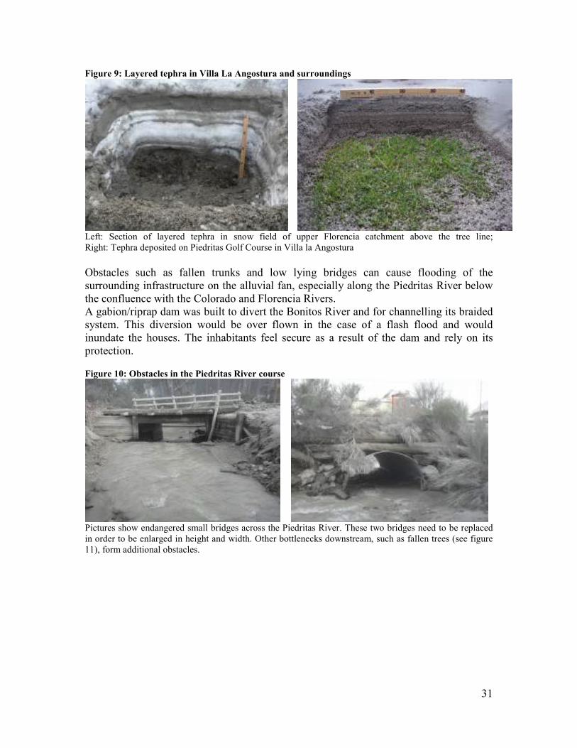
31
Figure 9: Layered tephra in Villa La Angostura and surroundings
Left: Section of layered tephra in snow field of upper Florencia catchment above the tree line; Right: Tephra deposited on Piedritas Golf Course in Villa la Angostura Obstacles such as fallen trunks and low lying bridges can cause flooding of the surrounding infrastructure on the alluvial fan, especially along the Piedritas River below the confluence with the Colorado and Florencia Rivers. A gabion/riprap dam was built to divert the Bonitos River and for channelling its braided system. This diversion would be over flown in the case of a flash flood and would inundate the houses. The inhabitants feel secure as a result of the dam and rely on its protection. Figure 10: Obstacles in the Piedritas River course
Pictures show endangered small bridges across the Piedritas River. These two bridges need to be replaced in order to be enlarged in height and width. Other bottlenecks downstream, such as fallen trees (see figure 11), form additional obstacles.

32
Figure 11: Volcanic ash and fallen trees in the Piedritas River
Some roofs have collapsed in the village and the vicinity. All roof collapses took place after the accumulation of wet ash from the fall of phase (II) above the lapilli, and the coarse ash fall of phase (I). In addition, the accumulation of snow on roofs further increased the stress on roofs and likelihood of collapse. Many of the collapsed roofs were poorly constructed and, hence, vulnerable to tephra over load. There is a continuing risk of further roof collapses in the case of exceptional snowfall for the buildings that have not yet been cleaned from the ash. This would be as a result of the combined weight of snow and wet ash. The cleared straight downward black-graded ski run on the orographic right side of Rio Bonito (see also satellite image above) has a steep unprotected slope. Landslides are probable there, with an additional hazard formed by the present load of sand and silt ash. The infrastructure below the ski run will at risk during sudden snow-melt or torrential rain. Figure 12: Lower black-graded ski run in Valle Bonito near Villa La Angostura
The photos of Figure 12 show the ash-covered bare soil of the lower black-graded ski run in Valle Bonito near Villa La Angostura. Populations and infrastructure will be at risk from possible mud-/debris-slides during intensive snow-melt or torrential rain on the unprotected ash covered slope.

33
Figure 13: Ash covers in Villa La Angostura
The photos in figure 13 show ash covered old trucks and partially cleaned roofs on houses in Villa la Angostura. In certain areas, at least 60 cm of snow has increased the burden on roofs and other vulnerable surfaces. In general, nature will recover quite fast in the north-western areas as there is sufficient precipitation (compare the situation of Los Antiguos Valley, which was affected in August to October 1991 with almost double the amount of ash, and suffered badly for six months, but largely recovered within three years). 3.3.2 Hazards in the area of Línea Sur / Ingeniero Jacobacci Southeast of San Carlos de Bariloche, along the Línea Sur Railroad and Autopista 23, fine ash has deposited, with substantial quantities especially between the Comallo settlement and around the city of Ingeniero Jacobacci (approx.10,000 inhabitants). The coarser sand fraction is not present in this area. The area is heavily affected by the mobile fine fraction of the ash which is severely affecting the lives and livelihoods of the rural population in this area, who mainly rely on subsistence agriculture and wool production. Due to the prevailing semi-arid climate, and with the extremely low level of rainfall so far this year11, this uniform silt/lime ash fraction remains dry and is unlikely to consolidate. As a result, this ash is easily mobilized by the prevailing daily westerly winds that transform themselves into ash storms. It is expected that this phenomenon will last for years to come. The fine ash has also entered houses and caused machines and appliances to break. The ash dust is very abrasive and directly affects populations, livelihoods and infrastructure. The sheep’s mouth, nose and teeth are eroded as a consequence and the quality of the wool is reduced.
11 According to INTA and personal communications, the area surrounding Ingeniero Jacobacci has been experiencing a drought for four years. From January to July of this year, only 17 mm of rain has fallen and only in the area between San Carlos de Bariloche and Clemente Onelli.

34
Figure 14: Satellite image of the Ingeniero Jacobacci area
Source: COSMO SkyMed, June 22 2011, SIASGE North is up and the baseline of the picture is 20 km (CONAE, 2011). The town is embedded on alluvial valley fill, generally surrounded to the north by basalt mesetas, and to the south by sedimentary rocks. A cinder cone is visible at the centre right of the image. The perennial river flows from the west and disperses to the east in wet grasslands, called mallines, and in drying-out salty lakes, called lagunas. The Línea Sur Railroad is visible as a west-southwest – east-northeast rending line. This railroad was closed after the eruption and reopened on 15 July 2011. Due to the abrasiveness of the ash, the population needs to protect the eyes with goggles and wear masks so as to avoid inhaling the ash. People are protecting themselves and no major negative effects have been reported thus far. The ash storms have also meant that the Línea Sur railway and transportation companies have not been able to service the area as the fine ash in the air seriously damages the filters, engines and wind shields of vehicles. Figure 15: Dust storm and deposited ash in the town of Ingeniero Jacobacci.

35
Rainfall could partially consolidate the silt fraction (the ash is heavier than water and would not be floating) but, lacking a natural cement, it will be remobilized, forming dust storms and dunes for several years. It will finally be deposited upslope, forming loess, or washed down to the swampy lowlands, called mallines. Wind can also transport ash from the basalt plateaus to lower lying areas, affecting the pastures for grazing. Figure 16: The influence of ash-fall in the Ingeniero Jacobacci area on the availability of pastures for
grazing
Source: INTA Jacobacci, 2011. Condition of the steppe ranging from good to weak against the thickness of the ash cover (despreciable=insignificant). The ash cover will vary, being blown away or accumulated according to the speed of the daily prevailing westerly winds. Sheep are most vulnerable, suffering on mouth and noses from the abrasiveness of the ash and from the weight of accumulating ash sticking in the wool. 3.3.3 Hazards in the San Carlos de Bariloche area San Carlos de Bariloche, a large city of approximately 130,000 inhabitants, was affected by a thin layer of sandy ash-fall (2 cm observed, up to 7 cm reported orally, with a maximum of 1 cm of fine ash). The city is confronted with the large amount of ash to be cleaned out but there has been no major direct distress. The population has cleaned most of the town from the ash already. The skiing area of Piedras Blancas is operating; it opened after the snowfall on the weekend of 15 July. San Carlos de Bariloche and surroundings
The sandy ash-fall in the San Carlos de Bariloche area was not as intensive as in Villa la Angostura. As a result, the environmental impact has been smaller, and the affected nature will recover quickly.

36
The extensive urban area has to address the problem of the large amount of sandy ash that has accumulated on and needs to be cleaned from paved surfaces and deposited. Restricted air traffic due to mobilized ash (airport is seen on the lower right of the picture below) is predicted to have a strong economic effect on this touristic region. Figure 17: Satellite image of the San Carlos de Bariloche/Lake Nahel Huapi area
Source: COSMO SkyMed, 10 June, 2011, SIASGE. North is up and the baseline of picture is 22 km (CONAE, 2011). On 10 June, the lake is still partially covered by pumice. Tephra accumulated later on the beaches and specifically on the northeast shore. San Carlos de Bariloche is clearly visible on the south shore of the lake and the smaller town of Dina Huapi is on the southeast shore of the lake. The mountain in the lower left of the picture is Cerro Otto with the Piedras Blancas ski resort. Figure 18: Photos of the ash-fall in San Carlos de Bariloche
Left: A parked car covered in volcanic ash (Source: AP, June 2011); Right: Cleaning the main square of San Carlos de Bariloche from tephra. The large quantities of material to be deposited outside of San Carlos de Bariloche posed a difficulty. (Source: Centro Cultural Argentino de Montaña)

37
4. Conclusions and Recommendations This chapter first outlines the conclusions regarding the likely future behaviour of the Cordón Caulle volcanic complex and the impact on the environment and its recovery. Then, the team’s recommendations for prevention and mitigation measures, monitoring systems, as well as recovery and preparedness aspects are presented.
4.1 Conclusions
4.1.1 Likely future Behaviour of the Cordón Caulle Volcanic Complex
Potential scenarios of the eruption evolution and likelihood of occurrence can be deduced by examining the following: I) overall evolution of the eruptive situation, volcanic activity and monitoring parameters; and, II) past behaviour of the volcano, including overall evolution of the volcano, and historical and pre-historical data information on past eruptive events.
Evolution of the 2011 eruptive event
The 2011 eruption of Cordón Caulle has been dominated by phase (I), in which a large volume of volatile-rich magma raised from the magma chamber to the surface and was explosively discharged into the atmosphere at high rate, and phase (II), in which magma raise declined moving the eruptive process towards a pulsatory behaviour (alternating short-lived explosions and quasi-sustained degassing at a low discharge rate). The late stage of phase (II) ultimately led to an effective magma/volatiles decoupling in the conduit and a rise to the surface of fully degassed magma (lava emission). The overall volcanic process can be interpreted as the result of a vigorous episode of magma extraction from the magma chamber during phase (I), followed by a steady decline of the magma extraction rate of phase (II). This type of transition is the result of a combination of different factors, such as: I) a drop of magma chamber pressure as a result of the evacuation of a substantial volume of magma from the chamber during phase (I); II) migration of magma fragmentation to shallow level; i.e. longer pathway the magma has to run from the magma chamber to the fragmentation level, III) increase in the magma viscosity induced by volatile (water) exsolution and associated formation of microlites; and, iv) increase in magma density as a result of gas release from the magma column (extrusion of lava from 20 July). The above-mentioned factors combine to substantially increase the density and friction of the magma column making the rising of magma in the volcanic conduit increasingly difficult. The overall behaviour of the process is expected to result in a rapid drop in the rising of magma and eventually in the cessation of volcanic activity. Monitoring data (seismic data) provided by SERNAGEOMIN is consistent with the above-described volcanic and magmatic scenario. Frequency of earthquakes peaked on 3 and 4 June, just prior to the eruption (up to 230 events per hour, anded) dropping significantly by 6 June (7 events per hour). Since then the cumulative seismic energy per time unit (number and energy of earthquakes per hour) steadily declined which suggests that the plumbing system of the volcano was rapidly recovering its equilibrium.

38
Past behaviour of the volcanic complex
Volcanic systems tend to exhibit similar eruptive behaviour over time and, as a result, the volcanic history (the archive of past eruptions) represents a fundamental tool to make inferences on their future activity. The volcanic history of Cordόn Caulle is quite well known for the last century where explosive events are reported in 1960, in 1921-22. Recently published information by Chilean volcanologists on pre-historical events represented important progress. Important scientific papers on the Puyehue-Cordόn Caulle Volcanic Complex and its volcanic history were published by Lara et al (2004), Lara et al. (2006 (I)), Lara et al. (2006 (II)). The team is aware of relevant studies that volcanologists of scientific institutions of Argentina are currently undertaking on the downwind side of the volcano (fall-out deposits) using both classical tephra studies and also by recovering cores from lake sediments where the archive is expected to be particularly complete and reliable (Gustavo Villaba, Univ. Nac. Conahue personal communication, Patricia Sruoga SEGEMAR personal communication, Romina Daga CNEA personal communication). The ongoing studies appear to be well focused and capable of assembling, in the near future, a robust database on prehistoric activity of Cordόn Caulle, including census of past events, assessment of eruption age and evaluation of the scale of individual eruptions.
During the field visits, the team members had the opportunity to access and examine some Holocene and late Pleistocene tephra successions in the Villa la Angostura area. Some sections consisted of intercalations of tephra with soil beds, others consisted of tephra beds alternating with alluvial sediments.
The qualitative observations made by the team members inform that: I) the thickness of the tephra unit deposited by the 2011 event compared well with other prehistoric tephra beds, and II) past tephra beds of pumice lapilli and ash beds consisted of single package supporting the idea that past events consisted in one main burst rather than a succession of large scale eruptions.
Taking into account the available information and observations directly made in the field, it was concluded that the likelihood of having, in a short time, another large-scale eruptive event was low.
Combining the two lines of evidence (evolution of the present eruption and past behaviour of the volcano), the overall conclusion can be made that a fairly rapid end to the eruption with a very low chance of a major explosive event in the short term is likely.
In this scenario, it is nevertheless important to highlight that even a violent, short-lived explosion can occur in the coming weeks or months at any time possibly and without any precursors, at least until lava extrusion has completely ceased. These events would, however, affect the Chilean side and produce mild effects on the Argentinean side.

39
It is worth mentioning that the Cordόn Caulle 2011 event was preceded by several other volcanic events in the volcanoes of the Southern Andean Chain the last fifty years and that almost all of them caused significant/severe effects in the Argentina territory due to tephra fall (Chaitén 1960, 2008, Hudson 1930, 1971, 1991, Llaima 1994, 2008, 2009, Cordόn Caulle 1921, 1960).
Moreover the present geodynamic activity observed in this sector of the Andean chain appears to be above the average level (several seismic events have recently occurred and another volcanic centre, the Peteroa volcano is currently experiencing a significant unrest).
4.1.2 Impact on the Environment and Recovery
The affected area of Patagonia is characterized by its huge areas of national parks. Due to the large areas affected by the ash fall and the considerable thickness of the deposits in some areas, an issue of concern is the impact on the environment and the likely timeframe for its recovery. While the impact on flora and fauna were not the focus of this analysis, the team decided to note some observations and cite examples from experiences in other countries regarding the impact on ecosystems and their recovery, which are referred to in this section.
Flora
In general, nature will recover quite fast in the north-western areas as there is sufficient precipitation (compare the situation of Los Antiguos Valley, which was affected in August to October 1991 with almost double the amount of ash, and suffered badly for six months, but largely recovered within three years). An overview of the US Geological Survey indicates that the layer of ash which deposited on the national parks in the area around Villa La Angostura can have serious effects on the growth of plants. Trees and bushes survive, but smaller plants such as pasture and1-year plants, are not likely to be able to grow through ash layers that exceed 150 mm (very thick burial). As the ash seems to be permeable for air and water, and on the basis of previous experience with volcanic ash falls of similar thickness, the team estimates that the vegetation will recover fast. even in the area of Villa La Angostura where the thickness of the ash could cause greater challenges. The ash layers in San Carlos de Bariloche and Ingeniero Jacobacci are sufficiently thin to allow plants to grow through them in the spring, assuming the ash does not form a solid crust, which was not observed. In general, volcanic ash, when deposits are not too heavy, is considered to have a beneficial effect on soil, such as an increase in fertility. An important secondary risk can arise from the additional fuel for forest fires that is provided by the trees and branches that have fallen due to the weight of the ash in the area around Villa La Angostura. The unusual volume of dead branches and trunks could also lead to an increase in the population of bark-beetles.

40
Fauna
In areas where the burial of the vegetation is thick, animals can find it hard to find food. Signs of distress of wildlife have been noted by the population such as pumas approaching human settlements, the absence of birds in some areas, and large gatherings of rabbits close to streets in search of food. Due to the abrasiveness of the ash, eyes, mouth, noses and teeth, and skin of animals can be affected.
Aquatic Animals and Fish
Due to the volcanic ash in suspension in the lakes, the water has become turbid. Some lakes are completely covered with floating volcanic rocks. This area of Patagonia is renowned for its trouts, which need clear waters to feed and breed. Also, the fish’s gills can get blocked due to the fine particles in the water. Additional material will erode from mountain slopes and sediment in rivers and lakes. Animals which feed at the bottom of the water may be affected by the large amount of sedimentation which may cause the food chain to be disrupted. There are several potential risks from volcanic eruption that can cause a direct increase in fish mortality. In the Angostura Parques region there is considerable concern regarding trout mortality. • Water turbidity: Trout will have difficulty in gathering food as these fish are
dependent on clear water. If the turbidity of the water stays too high for longer periods, this might affect the amount of trout in the natural waters.
• Coverage of the lake and riverbeds with a thick layer of volcanic ash: This would impair the possibility of benthic fauna feeding fish to reach their food.12
• Turbidity/fine particles blocking fish gills: Gills of dead juvenile chinook and sockeye salmon smolts were observed to be uniformly coated with mucus and volcanic ash after the Mount St.Helen eruption in 1980. No strongs evidence of abrasion or haemorrhage was seen. Impaired oxygen exchange is suggested as the primary cause of death. This would be the most logical explanation for observations of dead fish in the short term.
4.2 Recommendations
4.2.1 Prevention and Mitigation of Secondary Lahars/Mud Slides Even if there is no immediate and direct volcano generated geo-hazard for the population, technical advice on safety/evacuation zones should be given and mitigation/prevention measures should be taken to protect the population from possible geo-risks in the mid to long term, to prevent the loss of lives, livelihoods and infrastructure.
12 For example, see http://198.103.48.70/volcanoes/haz_e.php.

41
In the area of the thickest deposits northwest of San Carlos de Bariloche, including the border region with national parks and the city of Villa la Angostura, the mountains above the tree line can be the origin of secondary lahars/mud- or debris flows, entraining loose material from the unprotected slopes, rushing down into the populated areas and infrastructure down valley. Landslides or mud-/debris-flows could reach populated areas due to slopes being exposed to erosion. The mission team found that there is a risk of secondary lahars and mud / debris slides during the snowmelt on slopes exceeding 15 to 20 degrees of inclination. In order to determine when certain ski runs can be utilized, geotechnical stability analyses of the slopes are necessary. Due to the ash deposits the areas at risk of flooding and mud flows have expanded. In order to enable evacuations from these areas, further detailed modelling of areas at risk should be undertaken and early warning systems be established. Specific prevention and mitigation measures need to be taken: Recommendation 1: It is recommended to undertake detailed mapping and modelling
of risks of secondary lahars and mud slides in order to estimate
the velocity of such flows and their capacity to spread in the
lowlands. In order to be able to undertake such computer
modelling, high resolution stereo satellite imagery should be
obtained.13
Recommendation 2: On the basis of the detailed modelling of mud/debris flow risk,
zones at risk as well as safety and evacuation zones should be
adapted and mitigation measures be implemented along the
rivers and in possible flooding areas.
Recommendation 3: Open the waterways/flow profile of lower Piedritas and lower
Bonito Rivers for flash events and possible debris flows
including entrained trees. At least two bridges on Piedritas need
a larger flow profile, and a deviation dam on the Bonito River
requires reinforcement (see Risk Map of Villa La Angostura,
Molla, 2011).
Recommendation 4: All slopes without forests and with more than 15 to 20 degrees
of inclination need to be evaluated for their stability. A
particular example is the steep black-graded ski run in Villa La
Angostura. It is essential to undertake geotechnical analyses
before the snow-melt and implement prevention and mitigation
measures such as adjusting the opening of ski runs accordingly.
13 Precursors for computer modelling (using software such as Laharz, MSF, FLO 2D or RAMMS) are high resolution satellite imagery (like Terra SAR-X, which is capable of penetrating the forest cover), digital elevation models, surveyed valley sections, and modelling (simulation of possible size, velocity, reach/spread of avalanches/floods, and mud-/debris-flows). The necessary high resolution stereo satellite imagery, which is needed for this purpose, could not be obtained thus far.

42
Recommendation 5: Hydro-geologic monitoring of Florencia, Colorado, Piedritas
and Bonito Rivers in connection with the local meteorology,
creation of an early warning system with alarm thresholds.
Recommendation 6: It is recommended to evaluate the prevailing risks in detail and
to reduce them systematically (e.g. prevent construction in areas
at risk of inundations and mud flows).
Recommendation 7: Preparedness, risk reduction and awareness raising of
population, authorities, organizations and stakeholders to
prevent future damage and disasters.
4.2.2 Prevention and Mitigation Measures for other Geo-Hazards Recommendation 8: In order to prevent the remobilization of volcanic material, all
roofs should continue to be cleaned (including of the holiday
homes), as well as surfaced areas. Pumice floating in the lakes
and accumulated on the shores should be retained or be worked
into the soil where possible.
Recommendation 9: Accumulated floating tephra should be retained on water or
worked into the soil where possible to avoid remobilization.
4.2.3 Environmental Monitoring Systems and Toxicological Risk
Assessment The data available during the mission was not sufficient to undertake a full toxicological risk analysis. The available data points to a potential risk associated with the inhalation of particles with an extended exposure.
More details can be found in Annex IV to this report entitled “Environmental monitoring and chemical risks assessment from ash of the Puyehue-Cordón Caulle Volcanic Eruption 2011”.
Recommendation 10: Further sampling, analysis and continuous monitoring in
different locations and in regular intervals is necessary to
exclude potential health risks. Detailed recommendations for
monitoring and analysis can be found below.
Recommendation 11: Protective measures (wearing goggles, masks) regarding the
abrasiveness of the ash should be taken when cleaning up ash or
when ash is mobilized by wind.
Recommendation 12: Having noted the existing concern by the population regarding
potential health risks associated with the ash, it is of utmost
importance to inform the public regarding potential risks from
the volcanic material and protective measures, based on existing
and outstanding analyses.

43
Ash composition
Very few detailed characterizations of the ash are currently available. For a correct toxicological risk assessment, it is necessary to analyse the composition of the ash in detail. Semi-quantitative XRF analysis is a positive first approach, which can be performed very rapidly, and even with mobile XRF apparatus, making it possible to undertake field sampling and attain immediate results. For example, the Dutch Environment Assessment Module, as used by the UN, carries an XEPOS XRF instrument (in a laboratory vehicle), as well as a portable XRF instrument for analysis in situ.
Recommendation 13: It is recommended to follow-up the XRF semi-quantitative
analysis with a quantitative laboratory analysis using
inductively coupled plasma mass spectrometry (ICP-MS), or
graphite furnace atomic absorption spectrometry (GFAAS).
Each sample should also be characterized with one or more
leaching studies, which also characterize all of the minor
elements, such as heavy metals, in the leachate. Preferably ICP-
MS should be used as analytical method.
Recommendations on ash sampling and leachate studies are available, such as found on the website of the International Volcanic Health Hazard Network, IVHHN (http://www.ivhhn.org). A schematic representation of the analyses, which are ideally performed on ash samples for characterization, is displayed in figure 19.
More information on ash leachate sampling, and ranges of elements found in other volcanic ash, can be found in Witham et al. (2005) Volcanic ash-leachates: a review and recommendations for sampling methods, Journal of Volcanology and Geothermal Research 141:299-326.

44
Figure 19: Schematic representation of a protocol for analysis of ash samples (Source: International Volcanic Health Hazard Network, http://www.ivhhn.org

45
Furthermore, ash characterization only on the first days of an eruption, and only in a single location, is insufficient to address the variability of the ash composition over time. Reported levels of soluble fluoride in the ash from the Eyjafjallajokul eruption in Iceland, in samples collected on 14 April, 2010, ranged from 23-35 mg/kg of ash. The concentration of fluoride in the volcanic ash, however, increased up to a level of 850 mg/kg of ash in samples collected on 19 April, 2010. This increase may be related to the fact that less steam was produced which resulted in a reduced wash-off effect14.
The variation in the composition of the ash in space is not clear, it can, for example, be expected that the ash deposited in the Ingeniero Jacobacci region, which was of a much finer texture than the San Carlos de Bariloche deposits, will release higher concentrations of chemical components (e.g. fluorine) in a leachate study. The very course fraction which fell in the first days in the Angostura region, could, due to the much lower surface area, have much lower leachate values.
Recommendation 14: Ash samples should be taken in different locations and at
different points in time and analysed in order to be able to
properly analyze the potentially different ash content. Fresh ash,
which has not previously been in contact with water (snow or
rain) should be sampled.
Recommendation 15: If an analysis is needed of the ash leachate for a specific
situation, such as the leachate of ash deposits from cleaning-up
villages or towns, a specific leachate study of the material which
is deposited should be made, as this material is already
weathered, and might contain other contaminating components,
such as exhaust fumes, hydrocarbons from oil/gasoline and such
like. Parametres such as pH should be varied to establish their
influence on the composition of the leachate.
Possible Risk to the Population by Inhalation
For the region around Ingeniero Jacobacci, no monitoring results on inhalable particulates or their chemical characterisation were available during the mission. However, the particulates that are being remobilised by wind, movement of vehicles etc. are sufficiently abrasive and irritant for the eyes and for the respiratory tract to provoke coughing, asthmatic agitation, or inflammation of the eyes especially in the most susceptible individuals, such as the elderly, children, asthmatics and those with allergies.
Recommendation 16: The recommendations by the authorities should be followed to
wear protective goggles and masks when cleaning up ash and
when wind is mobilizing ash.
14 See http://www.earthice.hi.is/page/ies_Eyjafjallajokull_eruption

46
Recommendation 17: Public health authorities may want to consider providing
goggles and masks for the worst affected areas (Linea Sur).
Recommendation 18: Detailed awareness raising, especially with the population in
Linea Sur, organizations and stakeholders regarding protection
measures, health risks, effects on animals etc.
Recommendation 19: In the Linea Sur area, school opening times could be adapted to
the daily wind pattern in order to avoid that children are on their
way to or from school during the dust storms.
In and around Villa La Angostura and San Carlos de Bariloche, the same measures will need to be taken in case particulates are remobilised during the dry season.
Recommendation 20: Concentrations of PM10 particulates should be monitored. It is
recommended to refer to the recommendations given by the city
of Buenos Aires for the different PM10 concentration levels (see
table 3).
Table 3: PM10 Reference Values and recommendation for Buenos Aires
PM10 Reference Values
Level Colour Effect Recommendations
Up to 54 µg/m3 None None
Between 55 and 120 µg/m3
None None
Between 121 and 150 µg/m3
None None
Between 151 and 254 µg/m3
Increases the probability of an occurrence of respiratory symptoms and of an aggravation of pulmonary diseases such as asthma
Individuals with respiratory diseases such as asthma should not over exert themselves when outdoors.
Between 255 and 354 µg/m3
Increases respiratory symptoms and aggravates pulmonary diseases such as asthma; possible respiratory effects in the general population
Individuals with respiratory diseases such as asthma should not over exert themselves when outdoors.
Between 355 and 424 µg/m3
Significant increase of respiratory symptoms and aggravation of pulmonary diseases such as asthma. Increased probability of occurrence of respiratory effects in the general population.
Individuals with respiratory diseases such as asthma should not over exert themselves when outdoors. The general population, especially children and the elderly, should not over exert themselves when outdoors.
Over 425 µg/m3
Serious increase of respiratory symptoms and aggravation of pulmonary diseases, such as asthma. Respiratory effects in the general population.
Individuals should not over exert themselves when outdoors; individuals with respiratory diseases such as asthma should remain indoors.
Source: www.buenosaires.gov.ar/areas/med_ambiente/apra/calidad_amb

47
Recommendation 21: Upon the availability of the results of a chemical
characterisation of the PM10 particulates, it should be referred to
the risk calculations presented in this report for the Chrome and
Nickel components.
Recommendations for an air quality monitoring system
Monitoring of particulate levels (at least of PM10 particulates) in the cities of San Carlos de Bariloche and Villa La Angostura is necessary in order to evaluate the long-term impact of the event on air quality. Caution needs to be exercised in interpreting the concentration levels that will be measured given that the base line values are not known in the absence of previous monitoring in these locations. US and European legislation usually stipulates that base line data should be established during a period of at least three years.
Recommendation 22: The team recommends the continuous monitoring of PM10, and/or
PM2.5 particulate levels.
When the automatic sampling system used is equivalent to the reference method, the gravimetric determination of PM10 mass collected in a filter15, this kind of system is very advantageous because the concentrations are obtained continuously and this allows authorities to give the appropriate recommendations to the population in real time.
While gravimetry is the reference method it has the inconvenience to not be able to provide data rapidly as several days are needed for analysis, not taking into account the necessary transport to a laboratory equipped with the necessary equipment.
Taking into account the arid characteristics and the strong winds of the Línea Sur area, the presence of dust in the air is normal. Therefore, a continuous monitoring of outdoor air would not be a recommended practice.
Recommendation 23: For the Línea Sur area, a monitoring of PM10 and or PM2.5
particulates indoors (e.g. schools, hospitals), where the
population spends most of the day, is more appropriate.
For this type of environment, it is possible to find equipment for automatic sampling that would give access to measured concentration levels in real time.
15 Some automatic methods can introduce a sampling artefact given an under estimation of the real concentration of PM10 in the air.

48
Possible Risk to the Population by Ingestion
Recommendation 24: People should avoid ingestion of ash, even if it represents only a
small toxicological risk based on the chemical composition. Fruit
and vegetables should be thoroughly cleaned, and drinking water
should come from sources that are uncontaminated with ash, or
at least should be filtered to avoid ingestion of suspended
particles.
This is particularly relevant for the rural population where fine ashes are being remobilized on a daily basis, such as in the surroundings of Ingeniero Jacobacci.
Recommendations for a water quality monitoring system
Recommendation 25: In the coming months, analyses of the water distribution network
should be conducted on a regular basis.
Recommendation 26: It is also important to increase the monitoring of surface water in
the lakes and rivers around Villa La Angostura, and San Carlos
de Bariloche, and in the area of the Línea Sur train line.
This is especially important as in the Línea Sur area the team could witness that surface water is not only used for animals, but also for human consumption.
Due to the scarce leachate data available to date, it is difficult to determine which compounds should be included in the drinking water monitoring that are not included in the usual monitoring according to the Drinking Water Law.
Recommendation 27: Once leachate data will be available, a list of compounds to be
monitored should be established.
Recommendation 28: In view of the possible eco-toxicological effects on aquatic life,
surface water analyses should also take into account the lower
qualification limits for compounds such as aluminium, copper,
mercury and lead that are required for this purpose than for
human consumption.
Recommendation 29: When ash that has been cleaned from urban areas is deposited in
proximity to surface water, a monitoring of certain organic
compounds (such as polycyclic aromatic hydrocarbons, benzene,
and aromatic compounds) should be undertaken, if it is not
already a current practice.
Ingestion of Ash by Animals Extrapolation from the only available ash leachte study in San Carlos de Bariloche to the situation in Ingeniero Jacobacci might underestimate risk, such as by underestimating the amount of fluorine released from the ash.
Recommendation 30: Leachate studies of the ash should be performed for each region
for which an assessment is to be made.

49
Recommendation 31: In addition to toxicological risk assessments it should be
examined whether the physical abrasiveness of the ash causes
any problems to animals that ingest large quantities of ash.
4.2.4 Livelihoods Support The ash cover on the pastures in the Línea Sur area is severely affecting access to forage and exacerbating the effects of the drought that has been prevailing since 2007. While the town citizens have already cleaned streets and roofs, the sediment deposited in the surrounding sparsely vegetated hills and mesetas within this area supply ample material to form dust storms, dunes and deposits in the more fertile lower lying pastures called mallines. It is expected that this will have a lasting impact on the livelihoods of communities relying on subsistence agriculture in the area as the lack of precipitation enables the remobilization of ash with every wind. Recommendation 32: It is recommended to continue and extend livelihood support to
subsistence farmers as long as needed, such as by providing
supplementary feeding to animals.
Recommendation 33: Agriculture and horticulture will need to be adapted to the
changed conditions, also transport on road and rail, protecting
animals and machinery from damages by the abundance of
abrasive dust in the air.
Recommendation 34: Continuous monitoring of the meteorological and hydrological
conditions, including periodic sampling of the suspended dust.
Sampling of the accumulation of dust in the wet grasslands,
called mallines, in order to adapt farming practices and design
livelihood support accordingly.
4.2.5 Environmental Recovery Recommendation 35: Precautions must be taken against possible future forest fires
because of the large amount of broken trees, especially in pine
forests, that provide additional fuel for wild fires.
Recommendation 36: It is recommended that the effects on ecosystems are studied in
detail by the competent authorities and technical organizations
in order to determine appropriate prevention and mitigation
measures.
Recommendation 37: The limits of quantification for water analysis should be adapted
to evaluate the potential risk from e.g. chrome and aluminium
for eco-toxicological effects.
4.2.6 Suitable Ash Deposition Sites The total volume of volcanic material being cleaned out from urban areas is large and a sufficient number of appropriate dumping areas need to be identified and ash deposited accordingly.

50
Recommendation 38: Deposition of ash into lakes is not recommended as there are too
many uncertainties regarding the environmental impacts of
additional deposits to the lakes, as well as the risk of creating
slope instabilities under water.
Recommendation 39: Landfills should be envisaged on suitable sites, possibly in
abandoned quarries, taking in to consideration their
hydrogeology. The ash should be compacted layer by layer
(ideally 30cm each), incorporating the silt ash into the sand ash
with a bulldozer. The deposits should be covered by coarse
material with low permeability to avoid remobilization or
leachate. Meteoric water should be drained away.
Recommendation 40: Before deciding on the location to deposit the ash cleaned from
urban areas, the ash should be analyzed in order to determine
whether organic compounds from urban origin have been
incorporated. A specific leachate study of the material which is
deposited should be undertaken.
Recommendation 41: Clean sandy ash (that has not been contaminated with other
compounds from urban areas) should be deposited separately to
be possibly used for construction purposes after intensive
geotechnical tests of the products and their leachates.
4.2.7 Possible Uses for the Ash San Carlos de Bariloche is attempting to make use of the collected sandy ash. Test bricks were made with one part of cement to six parts of ash sand and were reported to harden within six days, as opposed to two days for normal cement bricks. This preliminary result seems to be encouraging, but, in the long term, such mixtures will fail without special additives. Recommendation 42: Geotechnical laboratory tests are recommended to find a durable
solution for brick production.
4.2.8 Preparedness for Future Events While the volcanic activity of this Puyehue – Cordón Caulle eruption is expected to diminish and calm down within the next couple of weeks or months, there is a recurrence of events in this part of the South Andean volcanic chain with a major event around every 50 years on average, and in recent years, the eruptions of the Hudson (1991) and the Chaitén (2008) volcanoes have been experienced in this area. The volcano Peteroa north of the Puyehue – Cordón Caulle is showing seismic activity since last September after having been dormant for more than 10,000 years and is starting to emit volcanic material. The prevailing winds usually blow the resulting volcanic material from the southern volcanic chain in Chile eastwards to Argentina. In view of the above, it is important to consider preparedness and risk reduction measures mitigating potential effects of future events.

51
Recommendation 43: The experience of this event should be used to prepare for future
events, including the establishment of procedures and protocols
for sampling, analysis, interpretation of results, prioritization of
essential analysis, and information management ensuring the
availability of data to support decision making and enable
public information on potential risks stemming from the ash and
which mitigation and prevention measures should be taken.
Recommendation 44: Monitoring systems for air, water and soil quality should be
established in order to be able to monitor the evolution of
parameters and to establish base line data.
Recommendation 45: It is recommended to institutionalize the bilateral monitoring of
volcanic activity by Chile and Argentina.
Recommendation 46: A seismic array along the border should be established in order
to monitor seismic and volcanic activity of the southern volcanic
chain in Patagonia.

52
References
Amaral A., Cruz J.V., Cunha R.T. and Rodrigues A. (2006) Baseline levels of metals in
volcanic soils of the Azores (Portugal). Soil and Sediment Contamination 15, 123-130.
ATSDR (2004a) Toxicological profile for Cobalt. U.S. Department of health and human services. Public Health Service. Agency for Toxic Substances and Disease Registry.
ATSDR (2004b) Toxicological profile for Strontium. U.S. Department of health and human services. Public Health Service. Agency for Toxic Substances and Disease Registry.
ATSDR (2005) Toxicological profile for Nickel. U.S. Department of health and human services. Public Health Service. Agency for Toxic Substances and Disease Registry.
ATSDR (2007) Toxicological profile for Barium and barium compounds. U.S. Department of health and human services. Public Health Service. Agency for Toxic Substances and Disease Registry.
ATSDR (2008a) Toxicological profile for Aluminium. U.S. Department of health and human services. Public Health Service. Agency for Toxic Substances and Disease Registry.
ATSDR (2008b) Draft toxicological profile for Manganese. U.S. Department of health and human services. Public Health Service. Agency for Toxic Substances and Disease Registry.
ATSDR (2009) Draft toxicological profile for Vanadium. U.S. Department of health and human services. Public Health Service. Agency for Toxic Substances and Disease Registry.
Baars AJ, Theelen RMC, Janssen PJCM, Hesse JM, Apeldoorn ME van, Meijerink MCM, Verdam L, Zeilmaker MJ (2001) Re-evaluation of human-toxicological maximum
permissible risk levels. RIVM Report 711701025.
Cellule Interrégionale d’épidémiologie Antilles-Guyane (2010) Risques sanitaires
possibles secondaires au phénomène de retombées de cendres suite à l'éruption du
volcan de Montserrat, Guadeloupe, 2010; Bulletin de veille sanitaire, No. 2, 2010, page 9-12.
Colette A, Favez O, Meleux F, Chiappini L, Haeffelin M, Morille Y, Malherbe L, Papin A, Bessagnet B, Menut L, Leoz E and Rouil L. (2010) Assessing the impact of the April
2010 Eyjafjallajökull ash plume on air quality in France. Atmospheric Environment, doi: 10.1016/j.atmosenv. 2010. 09 .064, 2010.
CONAE (2011) Evento Puyehue 2011, powerpoint presentation, unpublished.
CONICET (2011) Complejo Volcánico Puyehue - Cordón Caulle, unpublished.

53
Cronin S. J, Manoharan, V., Hedley, M. J., Loganathan, P. (2000) Fluoride: A review of
its fate, bioavailability, and risks of fluorosis in grazed-pasture systems in New Zealand. New Zealand Journal of Agricultural Research, 2000, Vol 43: 295-321.
Daga R., Serquis A., Cotaro C., Wilberger D., Ayala C., Scerbo E., Mogni L., Caneiro A. (2011) Análisis de Cenizas Volcánicas, Complejo Volcánico Puyehue-Cordόn Caulle,
Erupciόn 4 de junio 2011, CNEA, Centro Atόmico Bariloche, 2011.
De Boer et al (1996) Levels of rare earth elements in Dutch drinking water and its
sources. Determination by inductively coupled plasma mass spectrometry and
toxicological implications. A pilot study. Water Research, Volume 30, Issue 1, 1996, Pages 190-198.
D G Housley, K A Bérubé, T P Jones, S Anderson, F D Pooley, R J Richards (2002) Pulmonary epithelial response in the rat lung to instilled Montserrat respirable dusts and
their major mineral components. Occupational and Environmental Medicine, 2002; 59:466–472.
Directive 2008/50/EC of the European Parliament and of the Council of 21 May 2008 on ambient air quality and cleaner air for Europe.
Directive 2000/60/EC of the European Parliament and of the Council of 23 October 2000 establishing a framework for the Community action in the field of water policy.
EFSA (2004) Opinion of the Scientific Panel on Food Additives, Flavourings, Processing
Aids and materials in Contact with Food on a request from the Commission related to the
safety in use of rutile titanium dioxide as an alternative to the presently permitted anatase
form. EFSA Journal, 2004, 163:1-12.
EFSA (2005) Opinion of the Scientific Panel on Dietetic Products, Nutrition and
Allergies on a request from the Commission related to the Tolerable Upper Intake Level
of Phosphorus. The EFSA Journal, 2005, 233, 1-19.
EFSA (2006) Tolerable Upper Intake Levels for Vitamins and Minerals by the Scientific
Panel on Dietetic products, nutrition and allergies (NDA) and Scientific Committee on
Food (SCF), EFSA, Parma. ISBN 92-9199-014-0.
EFSA (2008) Safety of aluminium from dietary intake. Scientific Opinion of the Panel on
Food.
Gerlach D.C., Frey F.A., Moreno-Roa H., Lopez-Escobar L. (1988) Recent Volcanism in
the Puyehue—Cordón Caulle Region, Southern Andes, Chile (40·5°S): Petrogenesis of
Evolved Lava, Journal of Petrology, 1988, 29 (2): 333-382. doi: 10.1093/petrology/29.2.333.
Hickey R.L., Frey F.A., Gerlach D.C. and Lopez-Escobar L. (1986) Multiple sources for
basaltic arc rocks from the southern volcanic zone of the Andes: Trace element and
isotopic evidence for contributions from subducted oceanic crust, mantle and continental
crust, Journal of Geophysical Research, 1986, 91, 5963-5983.

54
EFSA (2008) Additives, Flavourings, Processing Aids and Food Contact Materials
(AFC), EFSA Journal, 2008, 754, 1-34.
EFSA (2010) Statement of EFSA on the possible risks for public and animal health from
the contamination of the feed and food chain due to possible ash-fall following the
eruption of the Eyjafjallajökull volcano in Iceland – Urgent advice. EFSA Journal 2010; 8(4):1593.
Fauque, L.; Gonzalez, R.; Tejedo, A.G. (2011) Reporte de situaciόn de tareas realizadas
desde el 22 de junio al 3 de Julio por el SEGEMAR en el área afectada por ceniza
volcánica. Erupciόn del Cordόn Caulle, SEGEMAR, 2011, unpublished.
Gaitán J.J.; Raffo F.; Ayesa J.A.; Umaña F.; Bran D.B. (2011) Zonificación del área
afectada por cenizas volcánicas, INTA San Carlos de Bariloche, 2001, unpublished.
Health Council of the Netherlands (2006) Guidelines for a healthy diet, The Hague: Publication No. 2006/21.
INTA, Estación Experimental Agropecuaria Bariloche, Laboratorio de Suelos (2011) Informe de Laboratorio, 10 June 2011.
INTA Jacobacci (2011) Cenizas Volcan: Reducción disponibilidad, unpublished.
Hufner R, Osuna C, INVAP, Divisiόn Ingeniería de Procesos (2011) Caracterizaciόn de
Muestras de Cenizas Volcánicas, Volcán Puyehue, C289-CCGG-9IPCA-001-A.
JECFA (1983) 571 Iron, WHO Food Additives Series 18, http://www.inchem.org/documents/jecfa/jecmono/v18je18.htm.
L.E. Lara, J.A. Naranjo, H. Moreno (2004) Rhyodacitic fissure eruption in Southern
Andes (Cordón Caulle; 40.58S) after the 1960 (Mw:9.5) Chilean earthquake: a structural
interpretation, Journal of Volcanology and Geothermal Research, 138, 127– 138.
L.E. Lara, H. Moreno, J.A. Naranjo, S. Matthews, C. Pérez de Arce (2006) Magmatic
evolution of the Puyehue–Cordón Caulle Volcanic Complex (40° S), Southern Andean
Volcanic Zone: From shield to unusual rhyolitic fissure volcanism, Journal of Volcanology and Geothermal Research, 157, 343–366.
L.E. Lara, Alain Lavenu, José Cembrano, Carolina Rodríguez (2006) Structural controls
of volcanism in transversal chains: Resheared faults and neotectonics in the Cordón
Caulle–Puyehue area (40.5°S), Southern Andes. Journal of Volcanology and Geothermal Research, 158, 70–86.
Lijzen J.P.A., A.J. Baars, P.F. Otte, M.G.J. Rikken, F.A. Swartjes, E.M.J. Verbruggen and A.P. van Wezel (2001) Technical evaluation of the Intervention Values for
Soil/sediment and Groundwater. Human and ecotoxicological risk assessment and
derivation of risk limits for soil, aquatic sediment and groundwater. RIVM report 711701 023, RIVM, Bilthoven.
Molla, E. (2011) Mapa de Riesgo, Villa la Angostura, Municipalidad de Villa de
Angostura, unpublished.

55
Musta B, H Fitria, W Soehady E & S Tahir (2008) Geochemical characterization of
volcanic soils from Tawau, Sabah. Geological Society of Malaysia, Bulletin 54, November 2008, pp. 33 – 36.
Nordberg, G.F. ; Fowler, B.A. ; Nordberg, M. ; Friberg, L.T. (2007) Handbook on the
toxicology of metals. 3rd ed. Elsevier, Amsterdam.
Oomen A.G., Janssen P.J.C.M., Dusseldorp A, Noorlander C.W. (2008) Exposure to
chemicals via house dust. RIVM report 609021064, RIVM, Bilthoven.
Poelman JNB (1975) Dichtheid van de vaste delen van rivierkleigronden. Boor en Spade
19:32–38. Regeling Bodemkwaliteit. Staatscourant 20 December 2007, 247: 67-90 (in Dutch).
Reykdal O, Thorlacius A (2001) Cadmium, mercury, iron, copper, manganese and zinc in
the liver and kidney of the Icelandic lamb. Food Additives & Contamination, Part A 18: 960-969.
RIVM-RIKILT Front Office Food Safety (2010) Risk assessment concerning the
potential exposure via food and feed to ashes from the Eyjafjallajökull volcano in the
Netherlands, d.d. 29 April 2010.
Schroeder, H.A., Mitchener M., , Balassa, J.J., Kanisawa M. and Nason A.P. (1968) Zirconium, niobium, antimony and fluorine in mice. Effects on growth, survival and
tissue levels, Journal of Nutrition, 95: 95.
Schroeder, H.A. and Mitchener M. (1971) Scandium, Chromium (VI), Gallium, Yttrium,
Rhodium, Palladium, Indium in Mice: Effects on Growth and Life Span. Journal of Nutrition, 101: 1431-1438.
SCF (1990) Reports from the Scientific Committee for Food (25th series), Opinion expressed 1990. Food science and techniques, 1991.
UNOSAT (2011) Satellite Imagery Review of Ash Deposit Patterns from Puyehue-
Cordón Caulle Volcanic Complex (PCCVC), UNITAR, Geneva, 22 June 2011.
Van der Veer, G. (2006) Geochemical soil survey of the Netherlands. Atlas of major and
trace elements in topsoil and parent material; assessment of natural and anthropegenic
enrichment factors. PhD Thesis Utrecht University, ISBN-10: 90-6809-388-6.
Verweij W.; van den Velde-Koerts T.; de Boer J.L.M.; Mennes, W. (1994) Zeldzame aarden in drinkwater en drinkwaterbronnen [Rare earth elements in drinking water and
its sources]. RIVM Report 734301003.
Witham CS, Oppenheimer C, Horwell CJ (2005) Volcanic ash-leachates: a review and
recommendations for sampling methods. Journal of Volcanology and Geothermal Research 141:299-326.

56
Annex I Terms of Reference
TERMS OF REFERENCE Geologist/Lahar Expert
Puyehue-Cordón Caulle Volcano Eruption – Argentina Technical Cooperation Mission
Joint UNEP/OCHA Environment Unit
On 15 June 2011, an official request for technical cooperation from Argentina has been received for the affected regions near the Puyehue-Cordón Caulle Volcano. In response to the request, a technical cooperation mission is proposed to determine immediate risks and hazards for the population stemming from lahars / volcanic mud and debris flows.
There is a need for a geologist / lahar expert to participate in a technical cooperation mission. The mission will be an independent and impartial assessment focusing on identifying the main risks and hazards, including prediction of lahar pathways and the possible provision of technical advice on safety / evacuation zones for the population.
The outcomes of the mission will include recommendations to the competent authorities on immediate mitigation and prevention measures to prevent loss of life.
Sponsoring agencies/countries are kindly requested to deploy their experts and/or equipment and cover for their travel (international and domestic), fees, insurance and daily subsistence allowance.
Skills and experience
The expert should have as a minimum:
� Academic degree (Masters or higher) in geology, volcanology or related areas of expertise;
� At least 10-15 years of field experience, with proven experience in risk assessment/modelling of lahars;
� Excellent intercultural communication skills; � Working knowledge of Spanish is preferred, but not required (Focal Point speaks
English); � Team player and ability to deliver under stressful field conditions; � Be available to travel to Argentina at short notice for approximately 2 weeks.

57
TERMS OF REFERENCE
Environmental Pollution Expert Puyehue-Cordón Caulle Volcano Eruption – Argentina
Technical Cooperation Mission Joint UNEP/OCHA Environment Unit
On 15 June 2011, an official request for technical cooperation from Argentina has been received for the affected regions near the Puyehue-Cordón Caulle Volcano. In response to the request, a technical cooperation mission is proposed to determine immediate risks and hazards for the population stemming from deposits of volcanic ash and gases and its subsequent impacts on surface water, subsistence agriculture etc.
There is a need for an environmental pollution expert to participate in a technical cooperation mission. The mission will be an independent and impartial assessment focusing on identifying the main risks and hazards. The environmental pollution expert shall advise on sampling methodology, analysis and interpretation of data on air and water quality. The expert is also expected to contribute to the analysis and interpretation of samples of lahar material. The quantity and location of interventions will be agreed with the national focal point.
The outcomes of the mission will include recommendations to the competent authorities on immediate mitigation and prevention measures to prevent possible loss of lives and adverse impacts.
Sponsoring agencies/countries are kindly requested to deploy their experts and/or equipment and cover for their travel (international and domestic), fees, insurance and daily subsistence allowance.
Skills and experience
The expert should have as a minimum:
� Academic degree (Masters or higher) in chemistry or a related area of expertise; � At least 10-15 years of field experience, preferably experience in risk/impact
assessment of pollution stemming from volcanic emissions; � Excellent intercultural communication skills; � Working knowledge of Spanish is preferred, but not required (Focal Point speaks
English); � Team player and ability to deliver under stressful field conditions; � Be available to travel to Argentina at short notice for approximately 2 weeks.

58
Annex II: Mission Itinerary
4 July Travel to Buenos Aires
9:15 Meeting with the acting Resident Coordinator, UNDP Deputy Resident Representative, Monica Merino Dominguez
10:00 -14:00 Meeting at Ministry of the Interior – briefing on the situation in affected areas of Patagonia and discussion on scope and objectives of the mission; participants: Civil Protection / Ministry of the Interior, White Helmets Commission / Ministry of Foreign Affairs, National Institute of Agricultural Technology (INTA), Ministry of Territorial Planning and Investment, Geological and Mining Service (SEGEMAR), National Commission for Space Activities (CONAE), National Council of Scientific and Technical Investigations (CONICET), Ministry of the Environment and Sustainable Development, Armed Forces, World Bank, United Nations
16:00 Technical Meeting at CONAE regarding satellite imagery
5 July
18:00 Meeting with Governor of Neuquén province, Jorge Sapag
10:00 Technical Meeting at SEGEMAR regarding available reports, monitoring data, maps
13:00 – 16:30 - Flight Buenos Aires – Esquel
6 July
16:30 – 22:00 car transfer to Villa La Angostura
09:30 Meeting with Technical Committee of Villa La Angostura, briefing on the situation, bilateral meetings compiling available information and reports
12:30 - 17:30 – field visit to international pass Samore, Rio Totoral, Lago Totoral, El Mallin area of Villa La Angostura
7 July
TV interview Canal 6
Geologists visit Cerro Bayo / Cuenca Florencia watershed area from top of the mountain down to Villa La Angostura
Environmental pollution experts take air samples with colleagues from SEGEMAR, discuss analyses available so far, discuss possible monitoring systems with public health authorities
8 July
TV interview avcn

59
Geologists visit Rio Piedrita and Rio Bonito watershed area
Environmental pollution experts review reports and analyses received so far
Meeting with the Governor of Neuquén province, Jorge Sapag
Newspaper interview with La Manana Neuquén
9 July
Meeting with mayor of Villa La Angostura, Ricardo Alonso
10:30 – 16:00 Transfer from Villa La Angostura to Ingeniero Jacobacci
16:00 – 18:30 Meeting with the Río Negro Civil Protection
Visit to air quality monitoring station and ash deposit site in Jacobacci
10 July
Environmental pollution experts meet with provincial environment officer
Meeting with the mayor of Ingeniero Jacobacci, Carlos Toro, and the technical committee of the Linea Sur area
Bilateral meetings compiling information on ash deposits, water and air analyses etc.
11 July
TV interviews Canal 10
8:00 – 12:00 Field visit to a farmer in Atraico and to a quarry
TV interviews Canal 10
12 July
12:00 – 18:00 transfer to San Carlos de Bariloche
Bilateral meetings with technical bodies to compile and analyse information:
11:00 -13:00 Instituto Nacional de Tecnología Agropecuaria (INTA)
11:00 - 13:30 Universidad Nacional del Comahue / National Council of Scientific and Technical Investigations (CONICET)
13 July
15:00 – 17:30 Centro Atómico
14 July 9:30 – 11:00 Meeting with local and provincial authorities and technical committee in San Carlos de Bariloche

60
Radio and TV interviews – Noticias 2, Canal Seis, Canal 10 and others
11:00 meeting with INVAP S.E. (Investigaciones Aplicadas Sociedad del Estado)
13:30 field visit to Cerro Otto – 15:30
Report writing
Report writing 15 July
11:00 Meeting with technical delegation of the Administration of National Parks
16 July Finalize observations and recommendations, 15:15 bus transfer to Buenos Aires due to cancellation of flights
17 July 11:00 arrival in Buenos Aires, prepare debriefing meeting
09:30 Meeting with United Nations Resident Coordinator, Martin Santiago
10:30 Debriefing with Civil Protection / Ministry of the Interior
18 July
15:00 Debriefing meeting with representatives of Civil Defence / Ministry of the Interior, White Helmets Commission / Ministry of Foreign Affairs, National Institute of Agricultural Technology (INTA), Ministry of Territorial Planning and Investment, Geological and Mining Service (SEGEMAR), National Commission for Space Activities (CONAE), National Council of Scientific and Technical Investigations (CONICET), Ministry of the Environment and Sustainable Development, World Bank, United Nations
19 July Return travel

61
Annex III: Definitions
Volcanic material
Tephra is fragmental material produced by a volcanic eruption regardless of composition, fragment size or emplacement mechanism. Airborne fragments are also called pyroclasts. Once clasts have fallen to the ground they remain as tephra unless hot enough to weld together into pyroclastic rock or tuff. In the vicinity of the volcano, coarser fragments, called lapilli, are deposited; the sandy fraction can be transported as far as up to a hundred kilometers. Light, porous, glassy lava is called pumice. The fine fraction of tephra, also called volcanic ash is different from ordinary dust. Its sharp, crystalline structure causes it to scratch and abrade surfaces when it is removed by wiping or brushing. In wet weather the ash deposits are dampened down and the air can be clear, but in drier weather ash can easily be stirred up and remobilized by wind and traffic. As a result suspended dust levels become much higher and can reach levels potentially harmful to health. Rainfall and wind are effective in removing the ash and grass and other plants will eventually bind it to the soil, but with large ash-falls this process is too slow and the ash must be cleaned up and taken away from populated areas. In addition, wind may also bring ash into areas which were previously clean so ash may be present in the environment for months or even years following an eruption. Together with the tephra and entrained air, volcanic gases can rise tens of kilometers into the Earth's atmosphere during large explosive eruptions. Once airborne, the prevailing winds may blow the eruption cloud hundreds to thousands of kilometers from a volcano. The gases spread from an erupting vent primarily as acid aerosols (tiny acid droplets), compounds attached to tephra particles, and microscopic salt particles. Downwind from the vent, acid rain and air pollution can be a persistent health problem when the volcano is erupting. Geo-Hazards
A mudflow is the most rapid (up to 80 km/h) and fluid type of downhill mass wasting. It is a rapid movement of a large mass of mud formed from loose soil and water. Similar terms are mudslide, mud stream, and lahar from volcanoes (see below). Variables considered important in mud flow development include water content, slope angle, available material, and degree of roughness. A debris flow is a fast moving, liquefied mass of unconsolidated, saturated debris, also including mud. It is differentiated from a mudflow in terms of the viscosity and textural properties of the flow. Flows can carry material ranging in size from clay to boulders, and may contain a large amount of woody debris such as logs and tree stumps. Flows can be triggered by intense rainfall, snow melt, or a combination of these. Speed of debris flows can vary from very slow to up to 80 km/h in extreme cases. Volumes of material delivered by single events vary strongly, depending on the material entrained.

62
A lahar is a type of mudflow or debris flow composed of slurry of pyroclastic material (tephra), rocky debris, and water. The material flows down from a volcano, typically along a river valley. The term is originated in Indonesia. Sometimes mud or debris flows formed by tephra material are called secondary lahars.
Lava flows are the least hazardous of all processes in volcanic eruptions. How far a lava flow travels depends on the flows temperature, silica content, extrusion rate, and slope of the vicinity of the volcano. A cooler lava flow will not travel far and neither will one that has high silica content. Such a flow would have a high viscosity (a high resistance to flow).
Environmental Monitoring
A leachate is a product or solution formed by removing soluble or other constituents through the action of a percolating liquid.
PM10 are particulates in suspension of a diametre smaller than 10µm.
PM2,5 are particulates in suspension of a diametre smaller than 2,5µm.

63
Annex IV: Environmental monitoring and chemical risks assessment from ash of the Puyehue-Cordón Caulle Volcano Eruption 2011
Emiel Rorije, RIVM, NL, Environmental pollution expert Expertise Centre for Substances / Inspection, Environmental and Health advise centre,
National Institute for Public Health and Environment, Bilthoven, The Netherlands.
Eva Leoz-Garziandia ([email protected]), INERIS, FR, Environmental monitoring expert Institut National de l’Environnement Industriel et des Risques, 60550 Verneuil-en-Halatte, France
UN Technical Cooperation mission to Argentina July 4-19, 2011
The risk assessment part of this report is based on the 2010 RIVM report 609400001/2010, by A. Dusseldorp et al.
“Vulcanic ashes from Eyjafjallajökull, risk assessment for the Netherlands” (in Dutch) and more specifically the
toxicological risk assessment chapters written by W.Mennes (Ch.4) and W. ter Burg (Ch.5). The assessment has been
adapted to the local situation in Argentina as well as possible based on the information gathered during the UN
technical support mission.
Contents: 1. COMPOSITION OF THE PUYEHUE ASH
ASH LEACHATE ANALYSIS. FLUORINE DOES NOT SEEM TO BE A POTENTIAL HEALTH RISK
2. AIR AND WATER MONITORING SYSTEM WATER MONITORING AIR MONITORING MONITORING NETWORK FOR PARTICLES
3. TOXICOLOGY of the ASH COMPONENTS EXPOSURE RISK ASSSESSMENT FOR HUMANS Health effects from ORAL exposure to Puyehue volcanic ashes Health effects from INHALATION of Puyehue volcanic ashes
Risk assessment for FARM Livestock Fluorine exposure of cattle 4. ECOTOXICOLOGICAL ASPECTS PUYEHUE ASH FALL Aquatic species / Fish Informe INERIS sobre la eco-toxicidad del fluor Land flora and fauna 5. REFERENCE VALUES TOXICOLOGY Oral toxicological reference values Inhalation toxicological reference values

64
1. COMPOSITION OF THE PUYEHUE ASH
Limited data have become available up to now with respect to the analytical composition of the volcanic ashes in the proximity of the volcano. It may be anticipated that the composition of the atmospheric ashes over different regions may deviate from this, but in a first approach the following information as provided by SEGEMAR could be considered the most detailed (Informe parcial 011 Q0236, dd 5 Julio 2011, O.T. No: 011520, para la Secretaria de Mineria). As a reference the values for the average composition of 5 ash samples collected near the Eyjafjallajökull volcano, April 14th, 2010, are given. Also the results from an ash leachate analysis (INVAP, ash sample June 4, 2011, C289-TCGG-9IPTS-001-A, included at the end of this document) are given (concentrations in the ash leachate study in mg/kg ash, i.e. a factor 1000 below the concentrations in the volcanic ash characterizations). Also two EDS characterizations of Puyehue ashes are given, to show consistency in the characterization of the ashes in different samples. The EDS analyses are however not capable of determining the minor elements, and can only serve as a course characterization of the ash, with only limited relevance for toxicology of the ashes.
Table 4. Characterization of the Puyehye ash fallout, leachate and comparison with
other volcanic ashes.
Puyehue XRF, La
Angostura (fecha?) Eyjafjallajokul
XRF Puyehue, EDS, Centro Atomico
Bariloche (fecha de prueba 4/6/2011)
Oxide g/kg ash g/kg ash 1) g/kg ash 2) g/kg ash
SiO2 639 577 704 700
Al2O3 159 155 149 150
Fe2O3 72 96 36.4 39.1
K2O 45 17 26.1 24
Na2O 35 53 51.1 64.4
CaO 26 52 15.4 15.3
TiO2 9.7 16 5.7 5.2
MgO 5.9 22 9 6.4
MnO 1.9 2.7

65
P2O5 1.4 7.5
99.50% 99.80% 99.80% 99.80%
Minor components
mg/kg ash
BaO 1100 466.8
ZrO2 1000 626.5
SrO 600 421.5
Cr2O3 200 99.4
ZnO 200 157.3
SO3 200 -
Rb2O 100 -
NiO 100 22.9
F - 26.6*
As - -
* The content of Fluorine in the Puyehue ashes is not directly reported in the XRF analysis, but was determined in an ash leachate study (INVAP C289-TCGG-9IPTS-001-A) which reports 0.7 microg/g ash in a leachate (final pH 5.2) in demineralised water of 50°C during 32 minutes. This leachate study also confirms the absence of the arsenic (not detected, detection limit 20 microg/g ash), at least not in a soluble form.
The following table compares the Puyehue ash composition with composition of ash reported for the Montserrat and Antigue volcanic ash. They are very similar, although a comparison of the minor components can not be made.
Table 5: Comparison of Puyehue ash composition with Montserrat and Antigua volcanic ash
Puyehue Montserrat 1_1997*
Montserrat 2_1997* Antigua_1997*

66
g/100g % % %
SiO2 63,9 64,83 60,6 58,46
Al2O3 15,9 15,96 18,51 18,7
Fe2O3 7,2 6 6,65 7,34
K2O 4,5 1,04 0,82 0,71
Na2O 3,5 2,5 2,65 2,39
CaO 2,6 5,5 7,33 8,51
TiO2 0,97 0,51 0,56 0,66
MgO 0,59 2,3 2,62 2,78
MnO 0,19 0,15 0,16 0,16
*Housley et al., 2002
The composition of the Puyehue ashes appear very similar to the Eyjafjallajokul ashes (major and minor components), and in general to any volcanic ashes (it appears (but is not specifically mentioned in the analysis (INFORME Parcial 011 Q0236, Secretaría de Mineria, fecha 2011/07/05) that more toxic elements like mercury, lead, arsenic are not present in the ashes in significant quantities.
ASH LEACHATE ANALYSIS
Only one single leachate study became available during our mission, a limited study which was performed on the ashes collected directly at the beginning of the volcanic eruption, and which aimed to determine the potential fluorine release from the ashes.
EFSA (2010) issued a statement (urgent advice) on the possible risks for public and animal health from the contamination of the food and feed chain due to possible ash-fall following the Eyjafjallojokul volcanic eruption in Europe. Focus lies initially on possible risks from fluoride in the volcanic ash as this chemical was identified in previous volcano eruption risk assessments as most critical compound related to health effects in both humans and animals.

67
The (extractable) fluoride content of the Puyehue ash appears to be very small (according to the INVAP ash leachate analysis with an ash sample from June 4), which would take away concerns for Fluorine as a main health risk for human and animals (through ash ingestion, inhalation and/or drinking water). EFSA for instance considered the risk of fluorine the most relevant in a first assessment of potential risks of the Eyjafjallajokul volcanic eruption (EFSA, 2010).
Reported levels of soluble fluoride in the ash from Eyjafjallajokul ranges from 23-35 mg/kg of ash in samples collected early (14-4-2010). The concentration of fluoride in the volcanic ashes increased up to a level of 850 mg/kg of ash in samples collected later on (19-04-2010). This increase may be related to the fact that less steam is produced resulting in a reduced wash-off effect http://www.earthice.hi.is/page/ies_Eyjafjallajokull_eruption; access date April 26, 2010). Both values are much higher (a factor of 30 up to 1200 times higher) than reported for the ash leachate from Puyehue. The Puyehue ash sample was taken on June 4th, which was very early in the volcanic eruption. Leachate studies from ashes collected later on will have to confirm the low fluorine content.
However, despite this low extractable fluorine content of the ashes, local river or lake concentrations exceeding the WHO drinking water limit of 1.5 mg/l can still not be excluded due to the large amounts of ashes deposited in the Puyehue national parquet and the town and surroundings of Vila la Angostura. Therefore monitoring of the water quality and the drinking water quality should be continued, including, but not limited to, fluorine analysis of the drinking water
It is recommended that more detailed (ICP-MS, or at least AAS) analysis on the ash leachates is performed, in order to find out all potential hazardous substances (heavy metals, fluorine, arsenic) that might be released in the longer term by the ashes. If these analyses become available an assessment can be made whether ash leachates (rain fall, surface water) will in the longer term pose a threat to drinking water and/or the ecology.
Analysis of the liquid leachate: 1. Electrolytical conductivity: 43,6 microS/cm (23,5°C) 2. pH: 5,2 (23,5°C) 3. Fluorine (F-): 0,7 microg/g 4. Arsenic (As): no detecta< 20 microg/g 5. Magnesium (Mg): 1,2 microg/g 6. Iron (Fe): 20 microg/g 7. Calcium (Ca): 2,2 mcrog/g Note: the sample was leached out in water at 50°C for 30 minutes.
Analysis on the ash: 8. Sulphur (S): 0,044 g/100g
One other leachate, which only specified exchangeable ions, is specified in an “INVAP informe de laboratorio, 10/6/2011” from Ing.Agr. Javier Ferrari. This informe is included at the end of this document. The ash sample was taken 5/6/2011, and the concentrations given are: Ca 184 mg/kg, Mg 19 mg/kg, K 58 mg/kg and Na 80 mg/kg, pH of the leachate 6.5. These ions are not expected to contribute to potential ash toxicity.

68
For comparison the range of leachate components from different volcanic ashes as summarized by Witham et al. [2005] are given in the following table.
Table 6: Leachate Components from different volcanic ashes (Witham et al., 2005)
Ion Number of studies
Range of concentrations (mg ion/kg ash)
Calculated water concentrations (mg/l) *
WHO drinking water guideline levels (mg/l)
Puyehue first leachate study (mg ion/kg ash)
Al 16 2.4 (Galunggung) - 2117 (Gorely)
0.096 - 84.68 0.2
As 8 0.01 (Popocatepetl) - <4 (Ruapehu)
0.0004 - 0.16 0.01 <20
Cl 42 3.8 (Mt. St. Helens) - 11160 (Irazu)
0.152 - 446.4 250 a
F 30 0.1 (Galunggung) - 2043 (Avacha)
0.004 - 81.72 1.5 0.7
Fe 22 0.01 (Mt.St. Helens) - 91 (Ruapehu)
0.0004 - 3.64 - 20
Hg 3 0.0001- 0.0087 (Mt.St. Helens only)
4 x10⁻⁶ – 3.48 x10⁻⁴ 0.001
Pb 12 0.001 - 17.56 (Popocatepetl only)
4 x10⁻⁵ - 0.7024 0.01
SO4 33 2.4 (Mt.St. Helens)-21775 (Popocatepetl)
0.096 - 871 500 b 440
Se 6 0.001 (Mt.St.Helens)-0.64 (Fuego)
4 x10⁻⁵ – 0.27 0.01
* The calculated water concentrations for each ion are derived using the ash-water dilution ration of 1:25 recommended here. Drinking water quality guidelines (WHO, 1993) for these ions are also provided for reference purposes. Note that the leachate concentrations for different volcanoes are derived using different methods and assume complete sampling of all the adsorbed ion mass.
a. no guideline value, but concentrations of this level can give rise to a detectable taste in water.
b. no guideline value, but gastrointestinal effects can result from ingestion of high levels.
69
The reported pH values for the leachates indicate that the ashes (at least at June 5th 2011) have very little capacity to influence the pH of waters and soil.
Two other leachates from samples taken on the 9th of June 2011, from Pichileufu, show identical low conductivity as the first sample, and the reported pH of the leachate of these samples is again only slightly acidic, 5.5 and 6.2 respectively. No other information on these leachates is given, but from the conductivity and the pH these ash samples seem similar to the sample taken on the 5th of june. All the leachates reported in the INVAP informe did not show phosphor in the analysis (< 1 mg/kg ash).
FLUORINE DOES NOT SEEM TO BE A POTENTIAL HEALTH RISK
EFSA (2010) issued a statement (urgent advice) on the possible risks for public and animal health from the contamination of the food and feed chain due to possible ash-fall following the Eyjafjallojokul volcanic eruption in Europe. Focus lies initially on possible risks from fluoride in the volcanic ash as this chemical was identified in previous volcano eruption risk assessments as most critical compound related to health effects in both humans and animals.
The (extractable) fluoride content of the Puyehue ash appears to be very small (according to the INVAP ash leachate analysis with an ash sample from June 4), which would take away concerns for Fluorine as a main health risk for human and animals (through ash ingestion, inhalation and/or drinking water). EFSA for instance considered the risk of fluorine the most relevant in a first assessment of potential risks of the Eyjafjallajokul volcanic eruption (EFSA, 2010)
Reported levels of soluble fluoride in the ash from Eyjafjallajokul ranges from 23-35 mg/kg of ash in samples collected early (14-4-2010). The concentration of fluoride in the volcanic ashes increased up to a level of 850 mg/kg of ash in samples collected later on (19-04-2010). This increase may be related to the fact that less steam is produced resulting in a reduced wash-off effect (http://www.earthice.hi.is/page/ies_Eyjafjallajokull_eruption; access date April 26, 2010). Both values are much higher (a factor of 30 up to 1200 times higher) than reported for the ash leachate from Puyehue. The Puyehue ash sample was taken on June 4th, which was very early in the volcanic eruption. Leachate studies from ashes collected later on will have to confirm the low fluorine content.

70
However, despite this low (initial) extractable fluorine content of the ashes, local river or lake concentrations exceeding the WHO drinking water limit of 1.5 mg/l can still not be excluded due to the large amounts of ashes deposited in the Puyehue national parque and the town and surroundings of Vila la Angostura. Therefore monitoring of the water quality and the drinking water quality, should be continued. The much lower quantity of ashes deposited in San Carlos de Bariloche and Ing.Jacobacci make unlikely that fluorine poisoning could play a role here. However, the composition and leachate of the ashes deposited in San Carlos de Bariloche, or in Jacobacci, could be very distinct from the first sample for which we have an analysis. Leachate studies of the specific ashes as collected in San Carlos de Bariloche and Jacobacci should be performed to confirm the low fluorine content of these specific ash fractions.
2. AIR AND WATER MONITORING SYSTEM
WATER MONITORING.
En las siguientes tablas se presentan todos los datos que se obtuvieron durante la misión sobre los análisis químicos de aguas de red y superficiales.
Los valores límites de la primera columna son los de artículo 982 de la ley Argentina relativa al “CODIGO ALIMENTARIO NACIONAL CAPITULO XII BEBIDAS HIDRICAS, AGUA Y AGUA GASIFICADA AGUA POTABLE” tomadas de internet y del informe “Erupción del Cordón Caulle- Recomendaciones para monitoreo de calidad de aguas durante la emergencia volcánica, de Gustavo Villarosa - Valeria Outes, INIBIOMA, CONICET”.
En este mismo informe se precisan niveles guía de calidad de agua para la protección de la vida acuática, agua dulce superficial. Para algunos compuestos como el aluminio, cobre, mercurio y plomo los limites son más bajos que los requeridos para el consumo humano. Sería importante poder analizar las aguas superficiales teniendo en cuenta estos valores y no los de la legislación de agua potable para evaluar la evolución de estos compuestos desde la erupción.
Los análisis de aguas superficiales que aparecen en las tablas siguientes Jacobacci (datos obtenidos gracias a: Dirección Provincial de Recursos Hídricos de la Provincia de Neuquén, Sección de gestión ambiental de la municipalidad de Ingeniero Jacobacci, Salud Ambiental del ministerio de Salud de Río Negro, Departamento Provincial de Aguas de la Provincia de Río Negro) fueron hechos teniendo en cuenta los límites de calidad de agua para consumo humano, como primera aproximación y debido a la urgencia del evento era importante tenerlos rápidamente. Para un monitoreo futuro algunos de los limites de cuantificación deberían bajarse.
En la tabla se pueden observar datos anteriores à la erupción del Chaitén, y anteriores y posteriores a la erupción del Cordón Caulle – Puyehue. No se puede señalar ninguna evolución notable de ningún parámetro.

71
Para información y complemento se pueden consultar las directivas europeas 2006/11/CE del 15 de febrero del 2006 (versión codificada de la directiva 76/464/CEE del 4 de mayo de 1976) sobre la polución causada por ciertas substancias peligrosas vertidas en el medio acuático, y la directiva 2000/60/CE del 23 de octubre del 2000 que establece un marco político comunitario en el ámbito del agua y fija como objetivo:
• Asegurar un buen estado de las aguas para el 2015,
• Reducir progresivamente los vertidos, emisiones o perdidas de substancias prioritarias
• Y suprimir para el 2021 los vertidos de substancias prioritarias peligrosas.
En Francia AQUAREF realiza estudios técnicos para proponer a las agencias encargadas de monitorear el agua la metodología y los medios los mas adatados. Par mas información referirse a la página web : www.aquaref.org

72
Tab
le 7
: Wat
er a
nal
ysis
dat
a fr
om t
he
Inge
nie
ro J
acob
acci
are
a
50
Km
oe
ste
de
Jaco
ba
cci
50
Km
oe
ste
de
Jaco
ba
cci
80
Km
su
d
oe
ste
de
Jaco
ba
cci
10
0 K
m a
l
sur
de
Jaco
ba
cci
10
0 K
m a
l
no
rte
de
Jaco
ba
cci
10
0 K
m a
l
no
rte
de
Jaco
ba
cci
80
Km
de
Jaco
ba
cci
Cle
me
nte
O'n
ell
i
Cle
me
nte
O'n
ell
i
Ma
nu
el
Ch
oiq
ue
Lip
etr
en
gra
nd
e
Co
lan
Co
nu
é
(po
zo)
Co
lan
Co
nu
é
(re
d)
An
eco
n
gra
nd
e
Lim
ite
s
(Art
ícu
lo 9
82
)1
6/6
/05
8/8
/08
16
/6/0
81
/7/0
93
0/7
/09
31
/7/0
98
/3/1
03
/3/1
13
/6/1
11
0/6
/11
22
/6/1
12
3/6
/11
pH
6,5
< x
< 8
,56
,72
6,8
6,8
87
,57
7,3
7,4
37
,23
So
lid
os
dis
ue
lto
s to
tale
s (m
g/L
)1
50
05
52
18
22
02
46
46
04
66
94
76
67
62
17
56
19
7
Du
reza
to
tal
(mg
/L,
Ca
CO
3)
40
02
28
16
72
00
18
41
90
19
01
56
14
07
2
Ca
rbo
na
tos
(mg
/L C
aC
O3
)0
00
22
50
00
Alc
ali
nid
ad
to
tal
(mg
/L C
aC
O3
)3
83
62
70
26
22
56
Bic
arb
on
ato
s (m
g/L
Ca
CO
3)
38
36
27
02
10
25
61
13
Aci
de
z (m
g C
aC
O3/L
) fe
no
ltle
ína
Ca
lcio
(m
g/L
, C
a2
+)
88
,35
0,5
46
,16
7,3
36
40
38
,51
9,2
Ma
gn
esi
o m
g/L
, M
g2
+)
32
0,4
17
,23
,82
32
11
4,6
5,8
Su
lfa
tos
(mg
/L)
40
09
8,3
59
8,2
42
,98
21
82
11
1,2
Clo
ruro
s (m
g/L
)3
50
48
,83
91
,22
27
,62
8,4
30
80
39
,75
,67
Ars
en
ico
(m
g/L
)0
,01
< 0
,05
< 0
,01
< 0
,01
< 0
,01
< 0
,01
< 0
,01
0,0
1<
0,0
5<
0,0
5<
0,0
10
,01
50
,01
Am
on
iaco
(m
g/L
)0
,2<
0,2
< 0
,2<
0,2
< 0
,20
,2
Nit
rito
s (m
g/L
)0
,1<
0,1
< 0
,01
< 0
,1<
0,1
< 0
,1<
0,1
< 0
,1<
0,1
< 0
,1
Nit
rato
s (m
g/L
)4
5<
10
< 0
,2<
10
< 1
01
48
< 1
0<
10
< 1
0
Flu
oru
ro (
mg
/L)
1,7
y 1
,5
1,9
1,7
0,6
40
,88
2,1
1,4
90
,96
1,7
< 0
,40
,73
0,8
50
,27
Hie
rro
(m
g/L
)0
,3<
0,0
5<
0,0
5<
0,0
5-
0,0
9<
0,0
5<
0,0
5
Plo
mo
(m
g/L
)0
,01
< 0
,05
< 0
,05
< 0
,05
< 0
,05
< 0
,05
--
0,0
5
Zin
c (m
g/L
)5
< 0
,10
,1<
0,1
< 0
,1<
0,1
Ma
ng
an
eso
(m
g/L
)0
,1<
0,1
< 0
,1<
0,1
0,1
--
< 0
,1<
0,1
< 0
,1
So
dio
(m
g/L
)2
00
82
17
58
9,7
Va
na
dio
(m
g/L
)-
-
Am
on
io (
mg
/L)
<0
,01
<0
,01
Po
tasi
o (
mg
/L)
Co
bre
(m
g/L
)1
Cro
mo
(m
g/L
)0
,05
Alu
min
io (
mg
/L)
0,2
Fó
sfo
ro r
ea
ctiv
o s
olu
ble
(m
g/L
)
Ing
Jaco
ba
cci
Gri
fo a
gu
a
ba
rrio
50
viv
ien
da
s
Ing
Jaco
ba
cci
Ing
Jaco
ba
cci
ba
rrio
Sa
n
Jua
n
Ing
Jaco
ba
cci
po
zo
Ing
Jaco
ba
cci
Ho
spit
al

73
Tab
le 8
Wat
er a
nal
ysis
dat
a fr
om S
an M
arti
n d
e lo
s A
nd
es a
nd
Vil
la L
a A
ngo
stu
ra a
rea
Ag
ua
1
(po
tab
le d
e
un
a c
asa
)
Bo
ca R
io
Qu
ilq
uih
ue
To
ma
Tra
bu
nco
Bo
ca T
om
a
Co
op
. A
gu
a
Mu
est
ra R
io
Co
rre
nto
so
(10
m a
gu
as
arr
iba
)
Mu
est
ra L
ag
o
Na
hu
el
Hu
ap
i (1
er
mu
ell
e l
ad
o i
zq.)
Mu
est
ra A
º
Pie
dri
tas
(Ne
uq
ué
n)
Mu
est
ra B
º
Vil
la M
an
zan
o
– c
on
clo
raci
ón
Mu
est
ra R
io
Bo
nit
o
Ag
ua
re
d
bo
mb
ero
s
Lim
ite
s
(Art
ícu
lo
98
2)
16
/6/1
1
pH
6,5
< x
< 8
,57
,17
(1
5,4
ºC)
7,2
4
(13
,7ºC
)
7,6
0
(14
,3ºC
)
6,9
6
(15
,7ºC
)6
,57
6,6
26
,35
6,6
76
,44
6,8
So
lid
os
dis
ue
lto
s to
tale
s (m
g/L
)1
50
0<
15
00
< 1
50
0<
15
00
< 1
50
0<
15
00
Du
reza
to
tal
(mg
/L,
Ca
CO
3)
40
0
Ca
rbo
na
tos
(mg
/L C
aC
O3
)
Alc
ali
nid
ad
to
tal
(mg
/L C
aC
O3
)
Bic
arb
on
ato
s (m
g/L
Ca
CO
3)
Aci
de
z (m
g C
aC
O3/L
) fe
no
ltle
ína
3,5
x1
0- 3
2,1
x1
0- 3
3,1
x1
0- 3
1,8
x1
0- 3
Ca
lcio
(m
g/L
, C
a2
+)
2,3
0 +
/- 0
,01
1,5
9 +
/- 0
,01
2,2
9 +
/- 0
,01
2,5
6 +
/- 0
,01
2,0
+/-
0,1
2,0
+/-
0,1
4,8
+/-
0,1
6,2
+/-
0,1
3,9
+/-
0,1
3,5
5 +
/-0
,01
Ma
gn
esi
o m
g/L
, M
g2
+)
1,0
8 +
/- 0
,01
0,9
7 +
/- 0
,01
1,0
3 +
/- 0
,01
1,0
5 +
/- 0
,01
0,6
0 +
/- 0
,01
0,7
2 +
/- 0
,01
1,2
0 +
/- 0
,01
1,6
0 +
/- 0
,01
1,1
0 +
/- 0
,01
0,7
3 +
/-0
,01
Su
lfa
tos
(mg
/L)
40
0<
25
0<
25
0<
25
0<
25
0<
25
0<
25
0<
25
0<
25
0<
25
0<
25
0
Clo
ruro
s (m
g/L
)3
50
< 2
50
< 2
50
< 2
50
< 2
50
< 2
50
< 2
50
< 2
50
< 2
50
< 2
50
< 2
50
Ars
en
ico
(m
g/L
)0
,01
< 0
,05
< 0
,05
< 0
,05
< 0
,05
< 0
,05
< 0
,05
< 0
,05
< 0
,05
< 0
,05
< 0
,05
Am
on
iaco
(m
g/L
)0
,2
Nit
rito
s (m
g/L
)0
,1
Nit
rato
s (m
g/L
)4
5
Flu
oru
ro (
mg
/L)
1,7
y 1
,5
< 1
,5<
1,5
< 1
,5<
1,5
< 1
,5<
1,5
< 1
,5<
1,5
< 1
,5<
1,5
Hie
rro
(m
g/L
)0
,3<
0,3
< 0
,3<
0,3
< 0
,3<
0,3
< 0
,3<
0,3
< 0
,3<
0,3
< 0
,1
Plo
mo
(m
g/L
)0
,01
< 0
,01
< 0
,01
< 0
,01
< 0
,01
< 0
,01
< 0
,01
< 0
,01
< 0
,01
< 0
,01
< 0
,01
Zin
c (m
g/L
)5
Ma
ng
an
eso
(m
g/L
)0
,1<
0,5
< 0
,5<
0,5
< 0
,5<
0,1
< 0
,1<
0,1
< 0
,1<
0,1
< 0
,1
So
dio
(m
g/L
)2
00
< 2
00
< 2
00
< 2
00
< 2
00
< 2
00
< 2
00
< 2
00
< 2
00
< 2
00
< 2
00
Va
na
dio
(m
g/L
)
Am
on
io (
mg
/L)
Po
tasi
o (
mg
/L)
0,6
1 +
/- 0
,01
0,6
0 +
/- 0
,01
0,6
3 +
/- 0
,01
0,6
3 +
/- 0
,01
0,4
3 +
/- 0
,01
0,3
8 +
/- 0
,01
0,7
0 +
/- 0
,01
0,9
5 +
/- 0
,01
0,8
3 +
/- 0
,01
0,4
1+
/- 0
,01
Co
bre
(m
g/L
)1
< 2
< 2
< 2
< 2
< 2
< 2
< 2
< 2
< 2
< 1
Cro
mo
(m
g/L
)0
,05
< 0
,05
< 0
,05
< 0
,05
< 0
,05
< 0
,05
Alu
min
io (
mg
/L)
0,2
< 0
,2<
0,2
< 0
,2<
0,2
< 0
,2
Fó
sfo
ro r
ea
ctiv
o s
olu
ble
(m
g/L
)<
0,2
5<
0,2
5<
0,2
5<
0,2
5<
0,2
5
9/6
/11
11
/6/1
1
Sa
n M
art
in d
e l
os
An
de
sZ
on
a V
illa
La
An
go
stu
ra

74
AIR MONITORING
Calidad del aire ambiente exterior
Los primeros resultados de calidad del aire en la zona afectada que pudimos obtener son de los días 13 al 18 de junio del 2011 realizados por el SEGEMAR. Estos resultados hacen referencia a las concentraciones medias diarias (24h de muestreo) de las partículas PM10 y TPS en las localidades de San Martin de los Andes y Piedra del Águila.
Los equipos utilizados por el SEGEMAR son de bajo volumen con un caudal de 5 litros por minuto. El método utilizado respeta las normas IO-31 e IO-2.4 de l’EPA (Environmental Protection Agency, USA) lo que garantiza la representatividad de la mediciones sobre 24 horas.
Las concentraciones observadas oscilan entre 11 µg/m3 y 414 µg/m3 con un valor promedio de 115 µg/m3 en San Martin de los Andes y entre 108 µg/m3 y 576 µg/m3 con un promedio de 335 µg/m3 en Piedra del Águila.
Los controladores ambientales del Departamento Laboratorio del OPDS realizaron durante los días 22 al 26 de Junio mediciones de calidad del aire en las localidades de Villa La Angostura, Piedra del Águila y San Martín de los Andes (Provincia de Neuquén) con una unidad móvil. Esta unidad móvil efectuó mediciones puntuales en diferentes puntos de cada localidad entre algunos minutos y algunas horas (no conocemos l tipo de sistema utilizado para medir las concentraciones de PM10). La concentración de partículas PM10 variaba de 15 a 40 µg/m3 en Villa la Angostura, alrededor de 20 µg/m3 en Piedra del Águila y entre 15 y 50 µg/m3 en San Martin de los Andes. Las concentraciones observadas son relativamente bajas pero no pueden considerarse representativas de los niveles de estas zonas y no pueden compararse a las concentraciones obtenidas por el SEGEMAR para 24 horas debido a la corta duración del monitoreo.
Las evoluciones diarias de las concentraciones de partículas están regidas por la presencia y cantidad de fuentes de emisión directas, de la posibilidad de formar aerosoles orgánicos segundarios por reactividad en la atmósfera y por las condiciones meteorológicas que pueden ser propicias o no a la dispersión de estas partículas. Por eso solo un muestreo medio de 24 horas puede considerarse representativo y adecuado para comparar los valores obtenidos a los valores limites definidos en los diferentes países los cuales están definidos de manera a garantizar el mínimo riesgo crónico a la populación.
De esta manera hasta la fecha solo los valores obtenidos por el SEGEMAR pueden compararse a los valores límites definidos por la legislación Argentina.
A falta de valores de base de las zonas afectadas y como punto de comparación se puede citar como ejemplo la evolución de la calidad del aire monitoreada por la asociación de control de calidad del aire (Guad’Air, www.gwadair.fr) de la isla de Guadeloupe (Antillas Francesas).
El día 11 de febrero del 2010 entró en erupción el volcán Soufrière Hill en la isla de Montserrat a 70 km. En la figura siguiente se pude observar la evolución de las concentraciones de las partículas PM10 en dos puntos de la isla y de las partículas PM2,5 y
SO2 en un solo punto (Bulletin de veille sanitaire N2, 2010).

75
Figure 20: Evolution of PM10 and PM2.5 particulates in Montserrat February 2010
Se observó un aumento importante de la concentración de las partículas PM10 entre unas horas después de la erupción y hasta unos 6 días después de la erupción. Los altos niveles de PM10 se produjeron primeramente debido a la caída de ceniza durante la erupción y después debido a una re-suspensión de la ceniza caída por el tráfico y la actividad humana a la que se sumaron las emisiones de partículas del tráfico habituales. Cabe señalar que no se observó ningún aumento de las concentraciones en SO2 en el aire y que los niveles de la partículas finas (PM2.5) no sufrieron variación alguna quedando a los niveles habituales para la época (entre 20 y 30 µg/m3). Esta información fue muy importante debido a que son las partículas más finas las que pueden penetrar hasta el sistema alveolar.
Teniendo en cuenta este caso preciso y aunque la intensidad de la erupción no haya sido la misma cabe esperar que una vez que la emisión de ceniza disminuya los niveles de partículas PM10 en las zonas afectadas vuelvan a sus niveles de base. Para poder confirmar esto el monitoreo que el SEGEMAR ha realizado en Villa La Angostura y en Jacobacci será muy importante.
A falta de valores de base relativos a la zona se han intentado relacionar los pocos datos disponibles a otros datos obtenidos en Argentina. En la figura siguiente se pueden observar las concentraciones 24 horas de las partículas PM10 medidas por el SEGEMAR en la Provincia de Neuquén así que las concentraciones medidas del 3 de junio al 9 de julio en la estación “Córdoba” de la ciudad de Buenos Aires.16
16 obtenidos en la página web: www.buenosaires.gov.ar/areas/med_ambiente/apra/calidad_amb

76
Table 9: Reference Values of PM10 and related recommendations for Buenos Aires
Referencia de PM10
Rango Color Efecto Recomendacion
Hasta 54 µg/m3
Ninguno Ninguna
entre 55 y 120 µg/m3
Ninguno Ninguna
entre 121 y 150 µg/m3
Ninguno Ninguna
entre 151 y 254 µg/m3
Aumenta la probabilidad de ocurrencia de síntomas respiratorios y agravamiento de enfermedades pulmonares, como asma
Personas con enfermedades respiratorias como asma, deben limitar los esfuerzos al aire libre
entre 255 y 354 µg/m3
Aumento de síntomas respiratorios y agravamiento de enfermedades pulmonares, como asma; Posibles efectos respiratorios en la población en general.
Personas con enfermedades respiratorias como asma, deben limitar los esfuerzos al aire libre
entre 355 y 424 µg/m3
Aumento significativo de síntomas respiratorios y agravamiento de enfermedades pulmonares, como asma, aumenta la probabilidad de ocurrencia de efectos respiratorios en la población en general
Personas con enfermedades respiratorias como asma, deben evitar las actividades al aire libre, el resto de la población en especial los ancianos y los chicos, deben limitar los esfuerzos al aire libre
mayor a 425 µg/m3
Serio agravamiento de síntomas respiratorios y enfermedades pulmonares, como asma. Aparición de efectos respiratorios en la población en general
Toda la población debe limitar cualquier esfuerzo al aire libre; las personas con enfermedades respiratorias, como asma deben permanecer en lugares cerrados.
Aunque esta comparación no se muy pertinente debido a la diferencia de nombre de habitantes, de fuentes de emisión, de topografía, de proximidad al Cordón Caulle etc. esta figura puede permitir situar las concentraciones observadas al único monitoreo regular que hemos identificado en Argentina.
Figure 21: Concentrations of PM10 (µg/m3) in Buenos Aires, San Martin de los Andes and Piedra del Águila - June / July 2011

77
A partir del día 11 y hasta el día 15 el mismo evento parece producirse en las tres zonas pero de distinta intensidad ya que las concentraciones máximas en la provincia de Neuquén se sitúan entre 400 y 600 µg/m3 y solo llegan a 200 µg/m3 en Buenos Aires.
Cabe señalar que las concentraciones de PM10 en Buenos Aires están medidas por un sistema automático (desconocemos el tipo de sistema utilizado) de partículas y no por gravimetría como es el caso de Piedra del Águila y de San Martin de los Andes.
Las únicas mediciones de partículas PM2.5 que conocemos las está realizando el centro atómico de San Carlos de Bariloche (información obtenida en el centro atómico durante una reunión el 13 de julio). Los muestreos son realizados con sistemas de bajo volumen y la masa de partículas es obtenida por gravimetría. La concentración máxima observada fué de 23 µg/m3 el 25 de junio. Teniendo en cuenta que la masa de las partículas se obtiene en ausencia de un ambiente controlado en temperatura y humedad como definido en las normas europeas y americanas los resultados comportan seguramente un nivel importante de incertidumbre. Si los tomamos como valor indicativo los niveles son relativamente bajos y próximos a los observados en las ciudades europeas incluso en la isla de Guadeloupe durante la erupción de febrero del 2010. Estos datos deben ser confirmados teniendo en cuenta las fuentes de polución de este tipo de partículas en las localidades correspondientes (tipo de combustible utilizado por los vehículos, calidad y tipo de madera utilizada en las chimeneas…).
En la zona de Jacobacci conseguimos obtener información sobre las partículas PM10 gracias a los monitoreos que las explotaciones mineras deben realizar para estimar el impacto de la explotación en el medio ambiente (Datos de CODEMA y de la Minera Comirna). En la tabla siguiente están los resultados obtenidos en las últimas campañas.
Come ya lo hemos señalado antes, se observan concentraciones de partículas PM10
alrededor de los 50 µg/m3 en los denominados puntos blancos (ubicados considerando las condiciones de viento predominante en la zona y utilizados para contrastar con los resultados obtenidos en las zonas de explotación). Estas concentraciones parecen estar en relación con la aridez característica de la zona ya que en esta zona el polvo en suspensión existe de forma natural.

78
Table 10: PM10 values from air quality monitoring related to mining activity
Calidad de aire interior
El SEGEMAR ha realizado muestreos en dos ambientes interiores, los resultados obtenidos en el hospital de Villa La Angostura y en una escuela de Jacobacci aportarán informaciones importantes sobre los niveles de exposición para una populación que se puede considerar à riesgo como son los enfermos y los niños.
A falta de datos de base, podemos citar como ejemplo y para tener alguna referencia cuando los resultados estén disponibles, las concentraciones medias observadas en Francia en los ambientes interiores obtenidos por el observatorio del aire interior durante una campaña nacional de monitoreo realizada en el 2007 en 567 residencias principales (ver tabla 11).
Table 11: Average PM10 and PM2.5 concentrations indoors, France 2007. séjour = salón
Explotacion Fecha de muestreo
PM10 (µg/m3) en puntos blancos
Sol Minerales y Servicios SRL
03/08/2009 55,55 41,66
Sol Minerales y Servicios SRL
6-8/09/2009 5,00 18,00
PERCA 04/08/2009 47,78 50,25
EXPORMIN 05/08/2009 55,55 41,66
TANDILLA SRL 06/08/2009 41,66 97,20
COMIRNA SRL 07/08/2009 41,66 111,11
MELLADO 08/08/2009 55,55 54,5
Sol Minerales y Servicios SRL
27/09/2009 52,18 40,98
PERCA 30/09/2009 43,21 48,25
EXPORMIN 28/09/2009 56,58 43,11
TANDILLA SRL 01/10/2009 58,98 74,34
COMIRNA SRL 03/10/2009 58,12 98,64
MELLADO 02/10/2009 56,16 52,37
Ingeniero Jacobacci (monitoreo nocturno)
27-30/09/10 61,02 34,16

79
En el 50% de las habitaciones las concentraciones de PM2.5 son superiores a 19,1 µg/m3 y a 31,3 µg/m3 para las PM10. Las concentraciones son superiores a 132 µg/m3 (PM2.5) y 182 µg/m3 (PM10) en 5% de las habitaciones. El informe completo puede ser consultado en la página www.air-interieur.org
En la tabla 12 se pueden observar también valores de referencia disponibles en otros países para las partículas en el aire exterior. Los criterios de calidad del aire exterior utilizados en Europa también están (directiva 2008/50/CE):
• 30 µg/m3 (media anual): Objetivo de calidad
• 40 µg/m3 (media anual) : valor limite
• 50 µg/m3 (percentil 90 de las medias diarias que no se puede sobrepasar mas de 35 veces al año) : valor limite
Table 12 PM10 and PM2.5 reference values for particulates (outdoors) in other countries
MONITORING NETWORK FOR PARTICLES
Para poder realizar un monitoreo de calidad de aire el primer paso es identificar el punto de muestreo, el cual deberá ser representativo de la zona. Por ejemplo la directiva europea para la calidad del aire 2008/50/CE preconiza que :
a) la ubicación de los puntos de muestreo destinados a la protección de la salud humana deberán determinarse de manera que proporcione datos sobre:
— las áreas situadas dentro de zonas y aglomeraciones donde se registren las concentraciones más altas a las que la población puede hallarse directa o indirectamente expuesta durante un período significativo en relación con el período considerado para el cálculo del valor o valores límite,
— los niveles de contaminación en otras áreas situadas dentro de zonas y aglomeraciones que sean representativas de la exposición de la población en general;

80
b) en general, la ubicación de los puntos de muestreo deberá ser tal que evite que se midan los microambientes muy pequeños en sus proximidades, lo que significa que los puntos de muestreo deberán estar ubicados de manera que sean, en la medida de lo posible, representativos de la calidad del aire de un segmento de calle no inferior a 100 m de longitud en los emplazamientos de tráfico y de al menos 250 m × 250 m en los emplazamientos industriales;
c) las estaciones de fondo urbano deberán ubicarse de forma que su nivel de contaminación refleje la contribución procedente de todas las fuentes situadas a barlovento de la estación. El nivel de contaminación no debe estar dominado por una sola fuente salvo en el caso de que tal situación sea característica de una zona urbana más amplia. Por regla general, esos puntos de muestreo deberán ser representativos de varios kilómetros cuadrados
Además, las contribuciones de fuentes naturales pueden evaluarse pero no controlarse. Por consiguiente, cuando las contribuciones naturales a los contaminantes del aire ambiente puedan determinarse con la certeza suficiente, y cuando las superaciones sean debidas en todo o en parte a esas contribuciones naturales se podrán sustraer, al evaluar el cumplimiento de los valores límite de calidad del aire. Las superaciones de los valores límite de las partículas PM10 debido al vertido invernal de arena o de sal en las carreteras también podrá sustraerse al evaluar el cumplimiento de los valores límite de calidad de aire, siempre que se adopten las medidas adecuadas para reducir esas concentraciones.
En lo que se refiere a la estación de monitoreo, los dispositivos de monitoreo deberían estar en cabinas climatizadas como es el caso en la ciudad de Buenos Aires.
Figure 22: Picture of an Air Monitoring Station in Buenos Aires
Para el monitoreo de las partículas PM10 y PM2,5 en Europa el método de referencia para la medición de partículas es como en Estados Unidos la gravimetría (norma EN 12341, www.cen.eu) no obstante, los sistemas de monitoreo automáticos permiten el acceso a la información mucho más rápidamente y permiten igualmente obtener perfiles diarios de la concentraciones. Por esta razón algunos países miembros utilizan este tipo de sistemas para monitorear las partículas. Para poder justificar su utilización éstos países tienen que probar que los dos métodos son equivalentes según un procedimiento estricto tanto en duración como en niveles de concentración. En Francia por ejemplo esta equivalencia ha sido probada por el LCSQA para dos tipos de sistemas (TEOM-FDMS para PM10 y PM2.5, y MP101M (ß gauge) para PM10). Los informes están disponibles en la página web : www.lcsqa.org

81
Una vez el monitoreo funcionando, estos sistemas automáticos no permiten diferenciar el origen ni las fuentes responsables de estas concentraciones. Para saber si las cenizas continúan a ser responsables de los niveles observados se deberá hacer un monitoreo de 24 horas en diferentes periodos del año con sistemas de bajo o alto volumen y hacer una caracterización química de los filtros, analizando como mínimo el carbón orgánico, el carbón elemental, los iones y cationes mayores etc. Gracias a un programa que combina caracterización química y modelización el INERIS pudo en le 2010 estimar la contribución de las partículas del volcán Islandés Eyjafjallojokul a las concentraciones de partículas medidas en el norte de Francia (Colette et al., 2010).
Para poder tener puntos de comparación, en la figura 23 se pueden observar como ejemplo, las concentraciones medidas de las partículas PM10 en el 2010 en la zona de los Alpes en Francia en ciudades de diferente tamaño (www.atmo-rhonealpes.org):
• Annecy : 18,892 habitantes
• Chamonix : 9,829 habitantes
• Passy : 10,094 habitantes
• Thonon les Bains : 28,980 habitantes
Figure 23: Concentrations of particulates measured in the Rhones-Alpes region, France, 2010
Y en la ciudad de Grenoble (153,426 habitantes) durante el mismo año en un punto urbano (www.atmo-rhonealpes.org):

82
Figure 24: Concentrations of particulates measured in the city of Grenoble, France, 2010
Hay que señalar que en ciudades más pequeñas que Grenoble se pueden observar concentraciones en PM10 del mismo nivel. Esto es en parte debido a la topografía y a las habituales inversiones de temperatura que se observan en invierno en estas zonas.
TOXICOLOGY of the ASH COMPONENTS
For the components which have been included in the analysis (see table 4) reference values for chronic or sub-chronic exposure have been collected from literature (see tables 18 and 19 Annex Reference Values Toxicology). These values were collected from RIVM reports or from other international evaluating organisations, such as ATSDR (USA), or EFSA. For Sc, Y and Zr, no values could be found from other organisations. No comprehensive descriptions of the various ash components, which are considered in this report, have been included. For details on the toxicological properties of the ash components, the reader is referred to the various source documents. In 1994, RIVM has derived preliminary TDIs of 0.5 µg/kg bw/d for Sc and Y from long-term studies in mice given these two elements at a single dose level of approximately 0.5 mg/kg bw/d via the drinking water (Schroeder and Mitchener, 1971). Since slight effects were observed at this dose level, an assessment factor of 1000 was used to derive the preliminary TDI. Also for Zr, a life-time single dose study in mice was identified (Schroeder et al., 1968) in which a dose of 0.5 mg/kg bw/d was identified as an effect level. Based on this observation a tentative TDI of 0.5 µg/kg bw/d could be derived in the same way as has been done for Sc and Y.
For some of the chemical elements considered no toxicological reference values were found, but some sources have indicated levels of exposure which were not associated with toxicity, based on human data. In these cases the exposure levels mentioned have been used in this report as “safe level” (SL) or “target value” (TV), see tables 18 and 19 Reference Values Toxicology). It is noted that levels at which toxicity could occur will be higher. Therefore, the use of these “safe levels” can be considered conservative.

83
EXPOSURE
No data on exposure of humans or animals via food or drinking water has been collected. For the risk assessment purposes a maximum safe ingestion level of ash will be calculated based on the toxicological data.
Inhalatory exposure might be calculated based on PM10 values measured in different locations, and assuming worst case scenario where there is 24 hrs/day exposure to the measured PM10 levels.
RISK ASSSESSMENT FOR HUMANS
Health effects from ORAL exposure to Puyehue volcanic ashes
Since no data are available at this moment to estimate exposure to ashes via vegetables, soil or drinking water, a different approach has been taken to get an impression of the possibility of health effects resulting from the possibly deposited material on vegetables. First, the maximum ash ingestion calculated to be without concern for the individual compounds was determined. Second, to put these calculations into perspective, the results were compared to data on the ingestion of ‘normal’ house dust and soil. It should be noted that the ‘behaviour’ of volcano ash, due to its specific composition, may be different from house dust. The conservative but realistically estimated amount of ‘normal’ house dust ingested is 100 mg/d for a child and 50 mg/d for an adult, which figures are used as defaults in exposure estimations by RIVM, based on an extensive literature search. The 95th percentile is 200 mg/d (Oomen et al, 2008). Also for soil ingestion, default estimates for risk assessment have been derived. These are 50 mg/d for an adult and 100 mg/d for a child (Lijzen, 2001).
Based on the reported concentrations in table 1 and health-based reference values for chronic or intermediate duration exposure (see Annex Reference values toxicology), estimates have been made of the maximum amount of ashes that would be anticipated not to result in health problems for the individual components in the ash samples. For this purpose, it is initially assumed that the materials analysed are 100% bioavailable: i.e. they will be completely released form the matrix and be fully absorbed. This may be considered an over-estimation as for many metals it is known that they are only absorbed to a limited extent, depending on the matrix in which they occur and on the presence of other ions (Nordberg, 2007). In principle this also relates to the materials used in toxicological studies but these were often selected for their relatively good bioavailability.
Silicium- and Titanium-oxide
However, the assumption of “full availability” is not suitable as an initial assumption for silicium oxide, which is so insoluble in water that hardly any absorption may be anticipated. The same is applicable for titanium oxide and for both substances an ADI “not specified” has been derived (SCF, 1990; EFSA, 2004). Therefore, silicon-oxide and titanium oxide will not further be considered in this evaluation, as they can not pose any risk due to insolubility.

84
Sodium
There is no upper level for sodium. However, the Health Council of the Netherlands (2006) indicated an upper target value of 6 g per day for intake of sodium chloride, which is equivalent to approximately 2.4 g of sodium per day, which value will be used to evaluate the possible exposure to sodium.
Aluminium and Manganese
For aluminium and manganese a Tolerable Weekly Intake (TWI) and an Upper intake Level of 1 mg/kg bw/w and 11 mg per person per day have been derived by EFSA (2008) and U.S. Food and Nutrition Board/Institute of Medicine (FNB/IOM 2001; as cited in ATSDR 2008a; b), respectively.
Rubidium
The available data are too limited to derive a reliable toxicological reference value. However, based on this very limited information, it could be anticipated that exposure levels less than approximately 3 mg RbCl/kg bw/d might be relatively harmless in humans. This would be equivalent to ca. 2 mg Rb /kg bw/d [see Annex Rubidium toxicity].
Table 13. Maximum Safe Ash Intake per Person (70kg body weight) per Day
Worst case (conservative) estimates.
ash
oxide
conc. element
ash
element
conc.
Toxicological
ref. value
max. ash
intake (70 kg
person)
mg/kg
ash MW mg/kg ash
mg/kg
bw/day gram ash pppd
BaO Ba 1100 137 985 0.2 14
ZrO2 Zr 1000 91.2 740 0.0005 0.05
SrO Sr 600 87.6 507 0.6 83
Cr2O3
Cr(III)
insoluble 200 52 137 5 2558
Cr2O3 Cr(III)
soluble, 200 52 137 0.005 3

85
and
Cr(IV)
ZnO Zn 200 65.4 161 0.36 157
Rb2O Rb 100 85.5 91 2 1531
NiO Ni 100 58.7 79 0.02 18
F F 0.7 19 1 0.12 12000
Al2O3 Al 159000 27 84176 0.14 0.1
Fe2O3 Fe 72000 55.9 50373 0.8 1.1
mg pppd gram ash pppd
K2O K 45000 39.1 37357 3000 80
Na2O Na 35000 23 25968 2400 92
CaO Ca 26000 40.1 18585 2500 135
MgO Mg 5900 24.3 3558 250 70
MnO Mn 1900 54.9 1471 11 7
P2O5 P 1400 31 611 3000 4908
From table 13 it can be seen that for most of the components, the amounts of ash that can be ingested before a health concern would be raised is well above 10 g per person per day. Only for a few elements, 10 g or less would not be without a health concern. These are Zr (0.05 g of ash/day), Al (0.1 g), Cr (3 g), Fe (1.1 g) and Mn (7 g). Possible risks associated with combined exposure to these elements have not been assessed, since there are only few elements for which 10 g or less would not be without concern and there is a lack of knowledge on this matter.

86
By comparison with the figure used to estimate exposure to indoor dust (100 mg/d for a child, see above), the maximum quantities that could be ingested could be exceeded for Zr and are just borderline for Aluminum. Taking into account a measured density of 0.5 g/cm3 for the Puyehue volcanic ash (Informe INTA included at the end of this document) an amount of 0.1 g would have a volume of 0.2 ml, equivalent to ~8 drops of water. However, based on the preliminary nature of the TDI and the absence of any knowledge of speciation or bioavailability (based on the highly oxidised state of the major components, it could be anticipated that these metals would also be present as their respective oxides, with probably limited or no bioavailability) it is highly unlikely that a temporary limited ingestion of amounts of ash above 0.1 g would actually pose a real health risk. In addition, TDIs which is used for Zr is derived from two single-dose long-term studies in mice, with limited study parameters (Verweij et al, 1994; Schroeder et al, 1968). In order to cover uncertainty in this limited database, a relatively high assessment factor was used to calculate this preliminary TDI.
For Al the maximum quantity of ash that can be safely ingested would be 0.1 g/d and for this small amount, the same considerations with respect to volume would apply as for Zr mentioned above. However, the TDI for Al is well-underpinned. For Al it was demonstrated that in volcanic ashes, it occurs in the oxidised form (Al2O3). The oral bioavailability in humans of the aluminium ion from drinking water is around 0.3% whereas bioavailability from food and beverages generally is considered to be lower, about 0.1%. However, it has been argued that the oral absorption of aluminium from food can vary at least 10-fold depending on the chemical forms present in the intestinal tract (EFSA, 2008). Direct information on the availability of Al from Al2O3 is not available, but since this material is only slightly soluble in water or in diluted acids (EFSA, 2008), it may be anticipated that absorption of Al from the ashes will not be higher than anticipated from food. The Al contents in Dutch soils are approximately 8% (Van der Veer, 2006) for which there is no known risk. It is noted that the amount of Al in the ashes is not significantly different from Dutch soils or from the average of the South-American continent (see table X), which in itself may indicate that risks determined by the procedure in the present evaluation, if any, are over-estimated and present a very worst-case scenario.
The maximum quantity of ash which could be ingested with respect to the contents of Cr is highly dependent on the assumption of the form of Cr considered. If it is assumed (worst case) that all chromium is in the soluble state, or in the hexavalent state, the maximum amount of ash for Cr would be ca. 3 g per day.

87
The maximum amount of ash that could be ingested with respect to exposure to iron (Fe) is approximately 1.1 g/d, based on a TDI derived by JECFA in 1983. Although EFSA (2006) did not derive a TDI, from earlier JECFA evaluations the “provisional maximum TDI” for iron was taken for the present evaluation. Data provided by EFSA would not indicate that for a life-time intake of an amount of iron up to the JECFA TDI would result in dangers to health for the normal population, but people suffering from heamochromatisis may ultimately develop a serious health condition from prolonged intake of iron at this level. However, the JECFA-TDI for iron has been derived for soluble forms of iron, and as iron in the ashes is present as an oxide, the absorption will be considerably less that the 10 – 20% which is absorbed from soluble sources under conditions of iron deficiency (EFSA, 2006). According to JECFA (1983), iron in the form of Fe2O3 is not bioavailable. This means that the maximum ash ingestion with respect to iron is (again) an overestimation of the risk and that ingestion of ash is therefore unlikely to result in iron toxicity.
Health effects from INHALATION of Puyehue volcanic ashes
The volcano Puyehue-Cordόn Caulle has sent into the atmosphere a huge amount of minerals in the form of particulate matter (ash), 15% of which consisted of particles falling into the PM10 category (as e.g. stated in “Analisis y caracterizacion de cenizas procendentes del Complejo Volcanico Puyehue – Cordón Caulle, depositadas en la ciudad de Neuquén y Alto Vlle de Río Negro 12-13 de Junio de 2011, from the Universidad Nacional de Comahue, Neuquén. Analisis realizados en los laboratorios de la Facultad de Ingenieria, Departamentos de Geologia y Petroleo (CIMAR-CPEM) y Departamento de Quimica). Because the larger particles will fall out closest to the volcano, it can be anticipated that the fraction of PM10 in the ash cloud over Argentina further away from the volcano will be considerably higher.
The chemical composition of the Puyehue volcano ash fallout was analysed by SEGEMAR (Informe Parcial 011 Q0236, Muestra de Rio correntoso – Pasarela – Ruta Vieja (011520-0001). A number of major elements, i.e. metal oxides such as SiO2, and a number of trace elements, e.g. chromium, nickel, and zinc were identified. For these elements the amount per kg ash has been given (see table 1).
Currently, local air samples have not yet been analyzed for the chemical composition and thus no risk assessment can be made based on actual air concentrations. Therefore, an alternative approach was chosen, i.e. the maximum ash concentration in air that is assumed to be without appreciable health risk has been determined for the individual elements. The concentration data and toxicological reference values for inhalation of the individual trace elements in ash (see table 3) were used to derive a ‘maximum ash concentration in air’. It is important to note that the measurements consider ash fallout of which it was estimated that 15% of the particles were smaller than 10 microns (fraction of particles that is respirable). In the calculations here it is assumed that 100% of the particles were respirable. Another assumption is that the air quality guideline for PM10 (40 µg/m3; EU reference value, year average) also covers the major components, i.e. the major (metal) oxides found in the ash, and therefore the toxicological values for the individual compounds in the group of major metal oxides (such as SiO2, Fe2O3, TiO2) have not been separately considered.

88
Table 14: Worst case calculations for maximum allowable ash concentrations in the air, for inhalation
as the exposure route.
ash
oxide
conc. element
ash
element
conc.
Inhalation
al Tox. ref.
value
max.
daily
exposure
to ash
max
allowable
conc. ash in
air
mg/kg
ash MW
mg/kg
ash mg/m3 g/day µg/m3
BaO Ba 1100 137 985 0.7 14.2 0.71 x10⁶
ZrO2 Zr 1000 91.2 740 1.75 47.3 2.4 x10⁶
SrO Sr 600 87.6 507 2.1 82.8 4.1 x10⁶
Cr2O
3
Cr(III)
insoluble 200 52 137 0.06 8.8 0,44x10⁶
Cr2O
3
Cr(III)
soluble,
and Cr(IV) 200 52 137 2.50E-06 0.00037 18
ZnO Zn 200 65.4 161 1.05 130.7 6.5 x10⁶
Rb2O Rb 100 85.5 91 7 1531 77 x106
NiO Ni 100 58.7 79 2.50E-06 0.00064 32
Ni
(target) 2.00E-05 0.0051 255
F F 0.7 19 0.7 0.008 228.6 11 x106

89
The ash concentration in the air that is required to be of concern for public health was
determined as follows:
Amount of ash in air (µg ash/m3) = ref. value (mg /m3) / [ash] (mg / kg ash) x 109
Amount of ash (g ash/day) = ref. value (mg /m3) x 20 m3 / [ash] (mg /kg ash) x 103
It is assumed that an adult inhales 20 m3 air per day.
These calculations show that for most trace elements very high ash concentrations (in the
range of 106 µg/m3 = g/m3) are required to be of concern for public health. However,
Two trace elements appear to be of concern (see table 3):
Chromium(VI): an ash concentration in the air of 18 µg/m3. This level is based on the additional risk of cancer of 1:106 at an exposure duration of one year, and assumes that the chromium concentration measured in the ash is completely soluble and bioavailable.
Nickel: an ash concentration in the air of 32 µg/m3. This level is based on the additional risk of cancer of 1:106 at life-time exposure duration. The target value set by the EU for air concentrations of nickel (20 ng/m3) would provide 1111 µg/m3 as cut-off value for the ash concentration.
It should be noted that the ash concentrations for chromium(VI) and for nickel are based on toxicological reference values with an exposure duration of one year or life-time, respectively. The approach to derive the ash concentrations for these elements is considered very conservative and worst case. The risk of exposure to chromium(VI) may be even lower considering the fact that chromium(VI) is generally reduced to its trivalent form chromium(III) (Baars et al., 2001). Also these calculations assume that Chromium and Nickel would be fully released from the ash particles and be as soluble as the substances in the studies from which the above mentioned reference values were derived.
To confirm the apparent risk of for inhalation of these two elements, the calculations should be repeated with the concentrations of these metals (Cr, Ni) as determined in a leachate study of the PM10 fraction of the Puyehué ashes. It is expected that the concentrations of these elements in the leachate (both of the complete ashes and the PM10 fraction) will give a bioavailable concentration of at least a factor of 100-1000 lower than what has been used in these calculations. If this is confirmed in leachate studies, it can be safely stated that there is no chemical/toxicological risk from inhalation of the volcanic ash particles. The general risk from inhalation of fine particles (PM10) in general is however still present (see the part on AIR MONITORING before this part).

90
Risk assessment for farm livestock
Animals foraging outside continuously ingest soil attached to grass, insects or worms. Therefore the most essential question is whether the volcanic ash contains elements that are normally not present in soil and may potentially affect the health of the animal. Table 1 shows the composition of the Puyehue volcanic ash observed. Information on soil compositions, specifically volcanic soils are used to compare the ash contents with. A paper on volcanic soil of the Azores (Amaral et al. 2006) and on volcanic soil of the island of Sabah, Malaysia (Musta et al. 2008) gave specific information on elemental composition of these soils. Data on the composition of Argentinian soil, more specifically Patagonian soil has not been retrieved. For comparison background values of (non volcanic) soil samples from the Netherlands as described by Van der Veer (2006) are also given.
Table 15: (Volcanic) Soil compositions
ASHES SOILS
Puyehue
XRF Eyjafjallajokul
XRF Malaysia Azores S.America
continent The
Netherlands
Major Elements g/kg ash g/kg ash g/kg g/kg
g/kg g/kg
Si 300 270 200-318 288 272-468
Al 84 82 68-158 80 5-88
Fe 50 67 48-79 44 0-62
K 37 14 0.4-3.7 20
Na 26 39 1.8-11 27
Ca 19 37 0.5-0.9 39 0-66
Ti 5.8 9.6 4.8-9.6 4.1 0.3-6.2
Mg 3.6 13 0.7-6.9 22 0-15.3
Mn 1.5 2.1 0.1-0.2 0-1.9
P2O5 0.6 3.3 0-0.3
Minor Elements
mg/kg ash mg/kg ash mg/kg mg/kg
mg/kg mg/kg
Ba 985 404-429 293-404 104-620

91
Zr 740 458-472 171-299 35-662
Sr 507 356 21-79
Cr 137 19-47 93-139 ND-958
9-128
Zn 160 124-132 114-132 72-258 0-332
Rb 91 20-43
Ni 79 15-23 10-69 3-483 0-63
As 5-10
Co 26-31 34-66 2-111
Cu 22-31 55-88 18-117 0-72
Pb 2-24 9-83 4-166
V 47-95 246-366 5-140
Cd nd-0.8 0-1.9
There are no major differences between the levels of trace elements in the volcanic ash and the volcanic soils of Malaysia, the Azores or the average soil composition of the South American continent. Compared to Dutch background soil the levels of trace elements like Zr, Cr, Zn and Ni in the ash could be considered high, but not to an extent that levels in soil and possibly crops grown on these soils could show clearly elevated levels that could cause an increased exposure of animals. Other elements like aluminium, iron, magnesium etc are normal constituents of soil. Aluminium e.g. makes up on average around 8% in soil. The content of aluminum results in a very similar level of 84 g/kg (8.4%) in the Puyehue volcanic ash. Iron on average makes up 5% of soil, as compared to 50 g/kg (5% of Fe) in the ash.
Even more convincing evidence that the composition of the volcanic ashes are very similar to (local) soil composition can be found in the data presented by Hickey et al. (1986) – Journal of Geophysical Research and Gerlach et al. (1988) – Journal of Petrology (data available from the authors of this report).

92
Fluorine exposure of cattle
Elevated levels of fluoride in volcanic ashes are a well-known cause of fluorosis in grazing animals. Cronin et al. (2000) using a model, suggested that at soil ingestion levels of 143-300 g/d by sheep and 900-1600 g/d for cattle, and a dietary F absorbtivity (bioavailability) of soil F (20-38%), total topsoil F concentrations in the range of 372-1461 mg F per kg could cause chronic fluorosis in sheep and 326- 1085 mg F per kg soil in cattle. At the reported level of soluble F of 0.7 mg/kg (informe INVAP, sample from 4-june 2011), it seems very unlikely that grazing animals in the Puyehue region will be exposed to such high levels. Furthermore it is noted that there will probably be no chronic increase in the levels of Fluorine.
It should be noted that in regions where the ashes are covering most or all of the animals food, the ingestion of ashes might (temporarily?) be much higher than the soil ingestion levels assumed by Cronin et al. However, there is a factor of ~500 between the reported soluble fluorine level in the Puyehue ash and the lower concentration causing fluorosis in cattle, making it very unlikely that livestock will develop fluorosis, even when grazing on grassland heavily covered with ashes.
4. ECOTOXICOLOGICAL ASPECTS PUYEHUE ASH FALL
Ash fall in the National Parques surrounding Villa la Angostura has been so severe that effects on the flora and fauna in these surroundings are very likely.
Aquatic species / Fish
There are several potential risk from volcanic eruption that can have a (direct) increase in fish mortality. In the Angostura parques region there seems to be considerable concern for trout mortality.
The first, most directly influencing parameter would be extremely elevated water temperatures. According to UK Daily Mail, and Diario LaTercera the riverwater rose to 45 degrees celsius. http://www.dailymail.co.uk/news/article-2002210/Chile-volcano-Eruption-turns-waterway-steaming-torrent.html,
http://diario.latercera.com/2011/06/17/01/contenido/pais/31-72995-9-estudio-sostiene-que-rios-del-Cordόn-caulle-no-estan-contaminados-y-son-potables.shtml
This elevated temperatures have not been reported for Argentinean rivers, and is very unlikely to have occurred in the lakes due to their very high volumes of water.
Other potential problems for fish/trout would be:
• Water turbidity. Trout will have difficulty in gathering food, as these fish are dependent on clear water. If the turbidity of the water stays too high for longer periods, this might influence the amount of trout in the natural waters.
• Acidity of the water. Vulcanos can emit large amounts of sulphur, which would lead to high acidic rainfalls. Also the ashes can influence the pH of the natural waters. See e.g. http://en.wikipedia.org/wiki/Taal_Volcano: "On some eruptions, the dissolution of acidic volcanic gases into the lake has resulted in the death of large numbers of fish and animals."

93
From the analyses of the surface waters (and drinking water) in the Angostura region this does not seem to be a problem for the Puyehue eruption, as pH of the natural waters is not changed, and also the leachate of the ashes does not indicate a great potential for influencing the pH.
• Coverage of the lake and riverbeds with thick layer of volcanic ashes. This would impair the possibility of benthic fauna feeding fish to reach their food. See also e.g. http://198.103.48.70/volcanoes/haz_e.php "There were many other lethal, secondary effects, such as the loss of fish-spawning habitat and riparian cover. Thick accumulations of ash and mudflows can kill the riparian cover (the normal trees and bushes that grow along steams and rivers), which keeps stream waters cool and liveable for fish". Although this does not directly concern trout, it could in the medium to longer term lead to a considerable decrease in all fauna of the rivers and lakes surrounding the Angostura region, where ash-falls were very dense
Turbidity/fine particles blocking fish gills. Fore example see reporting on the effects seen in the Baker River:
http://vulcan.wr.usgs.gov/Volcanoes/Baker/description_baker.html "An 1843 eruption resulted in a major fish kill in the Baker River" and of the effects of the Mount Helen volcanic eruption, Mount St Helen http://spo.nmfs.noaa.gov/mfr452/mfr4522.pdf: "The gills of dead juvenile chinook and sockeye salmon smolts were uniformly coated with mucus and volcanic ash; no gross evidence of abrasion or hemorrhage was seen. Impaired oxygen exchange is suggested as the primary cause of death." This might explain observations of dead fish in the short term.
• “Some Effects of Mt. St. Helens Volcanic Ash on Juvenile Salmon Smolts TIMOTHY W. NEWCOMB and THOMAS A. FLAGG
High levels of suspended sediments may cause mechanical gill damage (Herbert and
Merkens, 1961; Noggle, 1978) andlor blockage of the osmoregulatory surface (Ball,
1914; Kemp, 1949). In this study, mortalities appeared to be due to ash particles and
mucus causing blockage of the osmoregulatory surface. The gills of dead fish were
uniformly coated with ash particles and mucus, and live fish in the high ash
concentrations appeared lethargic. There was no gross evidence of abrasion or
hemorrhage of the gill filaments. Gills of fresh mortalities were uniformly dark red
after gentle irrigation. This suggests impaired oxygen exchange as the primary cause
of death. There are also possible detrimental effects resulting from the release of
water-soluble material (e.g., heavy metals or hydrogen ions) coating the ash.
Exposure to the soluble fraction filtered from a mixture of 25 percent (v/v) ash did not
result in mortalities even after 36 hours, whereas exposure to an insult of 25 percent
(v/v) ash resulted in 100 percent mortality within I hour. This further indicated that it
is the particulate matter, rather than soluble material coating the ash, that is acutely
harmful to salmonids.”

94
From the composition and leachate analysis of the ashes it seems likely that also for the Puyehue ashes the toxicological potential of the leachate (heavy metals, hydrogen ions) does not play a significant role in fish mortality. However, problems with blocked gills (short term), turbidity of the water (medium term, specific for trout) and ash coverings of lake and riverbeds (medium to long term) seem to be realistic, and it is expected that these problems will affect the fauna of the natural waters in the Angostura region considerably.
Se adjunta una nota redactada por el INERIS (www.ineris.fr) sobre la eco toxicidad del flúor (original en francés):
Nota sobre la toxicidad del fluor
La información directamente disponible en el INERIS concierne el fluor hidrogenado o acido fluorhídrico (acido débil), un as incoloro, corrosivo y sofocante muy soluble en el agua en la cual se disocia en los iones H3O
+ y F- (OMS IPCS, 2002). La fluorine (F-F) es también un gas corrosivo también soluble en agua que se disocia en el ion F- o forma acido fluorhídrico.
Comportamiento en el agua Generalmente, en el agua natural, los iones F- forman complejos estables con los iones Al3+ presentes. La formación de este complejo depende de la concentración de Al3 y del pH, la proporción del complejo Al-F siendo máxima para pH<5. En agua marina, la mayoría de los iones F- está libre y asociados al Mg2+ o al Ca2+. Generalmente los iones F- pueden ser encontrados en cantidades importantes en los sedimentos dado a la formación de precipitados (carbonato de calcio, Fosfato de calcio,…). También pueden pasar a la atmosfera gracias a la formación de aerosoles en la inter-fase aire/agua (ATSDR, 2003). Bio-acumulación Independientemente del grupo taxonómico estudiado, la bio-acumulación del flúor es relativamente escasa, un BCF inferior 2 ha sido medido para la trucha salmonada (Wright, 1997 citado por Slooff, 1988). Eco-toxicidad (mas precisamente en los peces) En el caso de los peces, una intoxicación aguda al fluoruro provoca los síntomas siguientes : letargia, apatía, anorexia, disminución de la respiración, aumento del fluoruro sanguíneo, piel oscura, secreción anormal de mucus, movimientos erráticos, perdida de equilibrio y finalmente la muerte. La toxicidad del F- está relacionada con el pH, la T°C y la dureza del agua. La toxicidad es más importante en las guas blandas que en las duras dado que la precipitación del fluor en fluoropatita, fluoruro de calcio o de magnesio (Camargo, 2003) es más importante en guas duras. Los datos sobre ecotoxicidad siguientes han sido la mayoría obtenidos con fluoruro de sodio, el cual se disocia en el agua para dar iones fluoruro, el cual como para H-N, estos resultados pueen utilizarse pr estudiar la toicidad del ion fluoruro (CE, 2001). Muchos datos están disponible solo unos pocos están coitdos en esta nota.

95
Table 16: Acute eco-toxicity of fluorine
Especie Condiciones y criterios de efecto
Valor (mg/L) Referencia
Algas dulzaquicolas
Scenedesmus sp CE50 96 horas Biomasa Substancia : NaF
43 Groth, 1975 citado por Slooff et al., 1988
Algas marinas Skeletonema
costatum CE50 96 horas Substancia : NaF
81 LeBlanc, 1984 citado por Slooff et al., 1988
Crustáceos dulzaquicolas
Daphnia magna
CI50 48 horas Inmobilidad Dureza : 250 mg/L 23,2°C Substancia : NaF
97 Dave, 1984 citado por Slooff et al., 1988
Crustáceos marinos
Americamysis
bahia
CL50 96 horas Mortalidad Substancia : NaF
10,5 LeBlanc, 1984 citado por Slooff et al., 1988
Insectos dulzaquicolas
Hexagenia limbata
CL50 96 horas Dureza : 145 mg/L 20°C Substancia : NaF
32,3 (10,3 – 51,6) Metcalfe-Smith et al., 2003
Oncorhynchus
mykiss
(trucha)
CL50 96 horas Mortalidad 5,4 – 6,3 cm Dureza 17 mg/L 12°C Substancia : NaF
51 Pimentel et Bulkley, 1983 itados por Slooff et al., 1988
Peces dulzaquicolas
Salmo trutta
CL50 192 horas Mortalidad 8 - 10 cm Dureza 21,2 mg/L 16,1°C Substancia : NaF
97,5 (76,8-123,8)
Camargo et Tarazona, 1991 citados por Camargo, 2003
Peces marinos Ambassis
natalensis
CL50 96 horas Mortalidad Salinidad 10, 20, 28 ‰ Substancia : NaF
> 100
Hemens et Warwick, 1972 citados por Slooff et al., 1988
Table 17: Chronic eco-toxicity of fluorine
Especie Condiciones y criterios de efecto
Valor (mg/L) Referencia
Algas dulzaquicolas Anabaena sphaerica
NOEC 72 horas
Concentración en
clorofila
24°C
pH 4,5
Substancia NaF
> 42 Ali, 2004

96
Especie Condiciones y criterios de efecto
Valor (mg/L) Referencia
Agmenellum
quadruplicatum
NOEC 2-3 semanas
salinidad 26 ‰
Medio enriquecido
Substancia NaF
≥ 100 Oliveira et al., 1978 citados por Slooff et al., 1988
Algas marinas
Amphidium carteri
NOEC 2-3 semanas
Salinidad 26 ‰
Medio enriquecido
Substancia NaF
50 Oliveira et al., 1978 citadàos por Slooff et al., 1988
Crustáceos dulzaquicolea
Daphnia magna
NOEC 21 días
Reproducción
Dureza : 250 mg/L
Substancia : NaF
3,7 Dave, 1984 citados por Slooff et al., 1988
Crustáceos marinos Grandidierella lignorum
NOEC 90 días
Fecundidad
Ciclo de vida
23 – 25°C
Substancia : no
especificada
4,153 Connell et Airey, 1982
citados por Camargo, 2003
Oncorhynchus mykiss
(trucha)
NOEC 21 días
Mortalidad
Dureza 12 mg/L
Substancia : NaF
4 Herbert et Shurben, 1964 citados por Slooff et al., 1988
Peces dulçzaquicolas
Oncorhynchus mykiss
(trucha)
NOEC 21 días
Mortalidad
Dureza 45 mg/L
Substancia : NaF
75 Herbert et Shurben, 1964 citados por Slooff et al., 1988
Peces marinos Mugil cephalus
NOEC 113 días
Mortalidad
23,5-27°C
Substancia : no
especificada
5,5 Hemens et al., 1975 citados por Camargo, 2003
Exposición por el sedimento
Chironomus tentans
CE25 10 días
Crecimiento
Dureza : 160 mg/L
20°C
Substancia : NaF
661,4 mg F/kg
sedimento seco Metcalfe-Smith et al., 2003
2 Dato grafico. Un sola concentración de NaF probada. 3En el articulo de Camargo (2003) este valor está indicado como una MATC. Concentraciones de fluoruro inferiores a este valor pueden estimular la fecundidad de las hembras.
INERIS propone 2 PNEC para controlar el nivel toxico en fluoruros en función de la dureza del agua: PNECagua blanda = 0,4 mg/L
PNECagua dura = 0,9 mg/L
Ali G. (2004). "Fluoride and aluminium tolerance in planktonic microalgae." Fluoride 37(2): 88-95. ATSDR. (2003). "Toxicological profiles for Fluorides, Hydrogen Fluoride and fluorine." Camargo J.L. (2003). "Fluoride toxicity to aquatic organisms: a review." Chemosphere 50(3): 251-264.

97
CE (2001). European union risk assessment report, Hydrogen Fluoride, Volume 8. European Commission - Joint Research Centre, Luxembourg Metcalfe-Smith J.L., Holtze K.E., Sirota G.R., Reid J.J. et de Solla S.R. (2003). "Toxicity of aqueous and sediment-associated fluoride to freshwater organisms." Environ Toxicol Chem 22(1): 161-166. OMS IPCS (2002). Environmental health criteria: 227 - Fluorides. World Health Organisation, International Program on Chemical Safety (IPCS), Geneva Slooff H.C.e.a. (1988). Basisdocument Fluoriden. RIVM, the Netherlands, 758474010 Fin de la nota del INERIS
Flora
See the indication from the US Geological Survey, specifically the indications for different ash layer thickness on agriculture, http://volcanoes.usgs.gov/ash/agric/index.html
This seems to indicate that the layer of ashes which came down on the Parques Nacionales will have serious effects on the growth of plants (Angostura and surroundings). Trees and bushes can survive, but anything (like pastures, 1-year plants etc.) is not likely to be able to grow through the ash layer which exceeds 150 mm (very thick burial).
• All non-woody plants are buried.
• Burial will sterilize soil profile by isolation from oxygen.
• Soil burial is complete and there is no communication from the buried soil to the new ash surface.
• Soil formation must begin from this new "time zero."
• Several hundred (to a few thousand years) may pass before new equilibrium soil is established, but plants can grow within years to decades.
However, this seems to refer to ash layers that “solidify” i.e. form a cement-like solid layer which becomes impenetrable for water and/or air. This would explain the mentioned “sterilization” effect. In the case of the Puyehue / Cordón Caulle ashes our observations are that the ashes have a structure/composition that does not lead to formation of cement-like layers. If the ashes are wetted (e.g. by rainfall or melting snow layers) they form a mudlike suspension, but upon evaporation of the water/drying of the ashes, they return to their state of very loose ashes, which can be easily remobilized by winds. It is therefore expected by us that the effects of the thick ash layers around the Angostura region and in the three national parcs will NOT be as serious as the US Geological Survey would indicate. It looks like plants will be able to grow through the ash layer, and recuperation of the nature in terms of years seems more likely than hundreds to thousands of years as indicated for ash layers exceeding 150 mm.
The ash layers in Bariloche and Ing.Jacobacci are thin enough to allow for plants in the spring to grow through them, if the ashes do not form a solid crust (which was not happening in both Bariloche and Ing.Jacobacci (see above).

98
RE
FE
RE
NC
E V
AL
UE
S T
OX
ICO
LO
GY
Tab
le 1
8:
Ref
eren
ce V
alu
es T
oxic
olog
y: O
ral t
oxic
ity
Tox
icol
ogy
of P
uyeh
ue a
sh M
INO
R c
omp
onen
ts
Ref
eren
ce v
alue
s B
a
Zr
S
r
Cr(
III)
in
solu
ble
Cr(
III)
so
lubl
e,
and
Cr(
IV)
Zn
Rb
N
i F
Typ
e M
RL
T
DI
M
RL
R
fD
TD
I U
L
- T
DI
U
L
Val
ue*
in
mg/
kg b
w/d
ay
0.2a
0.00
05g
0.6e
5l
0.00
5l 0.
36i
- 0.
02c
0.12
0h
Eff
ect
Nep
hrot
oxic
ity
Ten
tati
ve
valu
e S
kele
tal t
oxic
ity
no e
ffec
ts
obse
rved
at
high
est d
ose
test
ed
no e
ffec
ts
obse
rved
at
hig
hest
do
se te
sted
pert
urba
tion
of
Cu
hom
eost
asis
-
For
nic
kel
solu
ble
salts
; de
crea
sed
body
w
eigh
t an
d or
gan
wei
ght
At
high
er d
ose
leve
ls
haem
osid
eros
isi
Tox
icol
ogy
of P
uyeh
ue a
sh M
AJO
R c
omp
onen
ts
Ref
eren
ce v
alue
s A
l F
e K
N
a C
a T
i / S
i M
g M
n P
Typ
e T
WI
pTD
I S
L
TV
U
L
AD
I U
L
UL
“s
afe
leve
l”
Val
ue*
in
mg/
kg b
w/d
ay
0.14
k 0.
8h 30
00 m
g pp
pdi
2400
mg
pppd
n 25
00
mg
pppd
i "n
ot
spec
ifie
d"o
250
mg
pppd
i 11
mg
pppd
m
3000
mg
pppd
j

99
Eff
ect
test
icul
ar
toxi
city
ne
urot
oxic
ity
adve
rse
effe
cts
asso
ciat
ed
wit
h ir
on
over
load
No
spec
ific
li
mit
se
t;
the
valu
e of
30
00 m
g pp
pd w
as
repo
rted
to
be
w
itho
ut
effe
ct.
At
high
er
leve
ls
cond
ucti
ve
effe
cts
and
com
prom
ised
he
art f
unct
ion
Hyp
erte
nsio
n.
An
AD
I or
U
L
is n
ot a
vail
able
. T
he t
arge
t va
lue
is
a pr
acti
cal
guid
e w
hich
wil
l no
t re
sult
in
ex
cess
ive
hype
rten
sion
No
effe
cts
obse
rved
in
ep
idem
iolo
gi
cal s
tudi
es
AD
I ap
plie
s to
th
e ox
ide.
“n
ot
spec
ifie
d”
beca
use
of n
o ab
sorp
tion
/no
bioa
vail
abil
ity
Dia
rrho
ea.
No
spec
ific
ef
fect
at
hi
gher
ex
posu
res
was
in
dica
ted
No
spec
ific
ef
fect
set
a A
TS
DR
, 20
07;
c A
TS
DR
, 20
05;
e A
TS
DR
, 20
04b;
g S
chro
eder
et
al.
1968
; h
JEC
FA,
1983
; i
EF
SA
, 20
06;
k E
FS
A,
2008
; l
Baa
rs e
t al
., 20
01;
m A
TS
DR
, 20
08b;
n H
ealt
h C
ounc
il o
f th
e N
ethe
rlan
ds, 2
006;
o E
FSA
, 200
4.
* A
bbre
viat
ions
use
d: T
DI
= t
oler
able
dai
ly i
ntak
e, p
TD
I =
pro
visi
onal
tol
erab
le d
aily
int
ake,
UL
= u
pper
lev
el,
(i)M
RL
= (
inte
rmed
iate
dur
atio
n) m
inim
um r
isk
leve
l, R
fD =
re
fere
nce
dose
, TW
I =
tole
rabl
e w
eekl
y in
take
; SL
: “sa
fe le
vel”
; TV
: “ta
rget
val
ue”
for
expl
anat
ion
of S
L a
nd T
V: s
ee te
xt.

10
0
Tab
le 1
9
Ref
eren
ce V
alu
es T
oxic
olog
y: I
nhal
atio
n
Tox
icol
ogy
of
Puy
ehue
as
h M
INO
R
com
pone
nts
(air
qu
alit
y gu
idel
ine
for
PM
10
(40
µg/
m3;
E
U
refe
renc
e va
lue,
ye
ar
aver
age)
al
read
y co
vers
the
maj
or c
ompo
nent
s of
the
ash
, so
no in
divi
dual
tox
icol
ogic
al a
sses
smen
t is
nece
ssar
y fo
r th
e m
ajor
com
pone
nts.
Ref
eren
ce v
alu
es
PM
10
Ba*
Z
r
Sr*
Cr(
III)
in
solu
ble
C
r(II
I)
solu
ble,
an
d C
r(IV
) Z
n*
Ni
Ni
(EU
ta
rget
) F
Val
ue*
in
mg/
kg b
w/d
ay
40 u
g/m
3 0.
7 m
g/m
3 1.
75
mg/
m3
2.1
mg/
m3
60 u
g/m
3 2.
5 ng
/m3
1.05
m
g/m
3 2.
5 ng
/m3
20 n
g/m
3 8 ug
/m3
Ref
eren
ce
/ re
mar
ks
Yea
r av
erag
e E
U
refe
renc
e va
lue.
EU
D
aily
av
erag
e no
t to
be
exce
eded
m
ore
than
35
da
ys/y
ear
is
50
ug/m
3
MR
L:
AT
SD
R
2007
, ne
phro
path
y m
ice.
R
fC
is
anal
ogou
s to
ora
l RfD
TD
I R
fD:
EP
A
IRIS
200
2 M
TR
: R
IVM
-re
port
60
1782
026/
2010
Add
itio
nal
risk
of
ca
ncer
of
1:
106
at
expo
sure
du
rati
on
of
a ye
ar. B
aars
et
al.,
2001
; R
IVM
. R
epor
t 71
1701
025
MR
L:
AT
SD
R
2005
, bo
dy
copp
er
stat
us
in
wom
en.
RfD
: E
PA
IR
IS 2
005
Add
itio
nal
risk
of
canc
er
of
1:10
6 at
li
felo
ng
expo
sure
du
rati
on.
Tar
get
valu
e.
EU
, 20
05
* T
he t
oxic
olog
ical
ref
eren
ce v
alue
for
inh
alat
ion
have
bee
n de
rive
d us
ing
the
oral
ref
eren
ce v
alue
(M
RL
, MT
R, R
fD, T
DI)
as
poin
t of
dep
atur
e (R
C =
Rdo
se x
Bw
/ in
hale
d ai
r pe
r da
y), w
here
the
body
wei
ght w
as s
et a
t 70
kg a
nd th
e in
hale
d ai
r pe
r da
y is
set
at 2
0 m
3/da
y as
def
ault
s.


