1 TECHNICAL MEMORANDUM Feasibility Assessment of Anacostia Riverwalk “Gateway “ Trail Segment Alignment/Connection PREPARED FOR: District Department of Transportation, District Office of Planning UPDATED BY: CH2M, Toole Design Group COPIES: Tom Ryburn, CH2M Richard Staudinger, CH2M DATE: July 24, 2015 Background In January 2015 the District’s Area Neighborhood Commission (ANC) 5C passed a resolution in support of a new “Gateway” Segment of the Anacostia Riverwalk that would provide a connection from Fort Lincoln and surrounding neighborhoods across the Anacostia River to the Anacostia Riverwalk Trail, Kenilworth Segment, which is currently under construction in NE DC. The route requested by ANC 5C is approximately two miles in length. The proposed trail routing begins at the intersection of Bladensburg Road, NE and South Dakota Avenue, NE. From there, it is proposed to continue northeast along Fort Lincoln Drive, and then depart the roadway to follow a Pepco utility corridor along the District of Columbia/Maryland border. In the area of New York Ave. NE (US Route 50) and the Anacostia River, it would turn to the southwest through an undeveloped area to intersect New York Ave, NE. The ANC’s plan includes a crossing of the Anacostia River via the existing New York Ave Bridge and a connection to the Kenilworth Trail Segment on the east side of the Anacostia River. The eastern terminus of the trail would fall in Maryland on NPS property administered by the Maryland National Capital Parks and Planning Commission (M-NCPPC). The ANC’s requested alignment is shown in Figure 1 below.
Transcript
1
T E C H N I C A L M E M O R A N D U M
Feasibility Assessment of Anacostia Riverwalk “Gateway “ Trail Segment Alignment/Connection
PREPARED FOR: District Department of Transportation, District Office of Planning
UPDATED BY: CH2M, Toole Design Group
COPIES: Tom Ryburn, CH2M Richard Staudinger, CH2M
DATE: July 24, 2015
Background
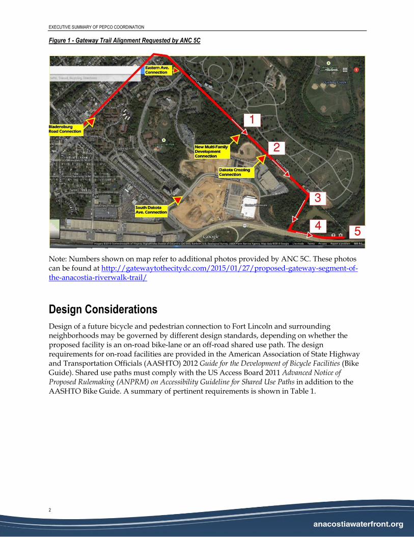
In January 2015 the District’s Area Neighborhood Commission (ANC) 5C passed a resolution in support of a new “Gateway” Segment of the Anacostia Riverwalk that would provide a connection from Fort Lincoln and surrounding neighborhoods across the Anacostia River to the Anacostia Riverwalk Trail, Kenilworth Segment, which is currently under construction in NE DC. The route requested by ANC 5C is approximately two miles in length. The proposed trail routing begins at the intersection of Bladensburg Road, NE and South Dakota Avenue, NE. From there, it is proposed to continue northeast along Fort Lincoln Drive, and then depart the roadway to follow a Pepco utility corridor along the District of Columbia/Maryland border. In the area of New York Ave. NE (US Route 50) and the Anacostia River, it would turn to the southwest through an undeveloped area to intersect New York Ave, NE. The ANC’s plan includes a crossing of the Anacostia River via the existing New York Ave Bridge and a connection to the Kenilworth Trail Segment on the east side of the Anacostia River. The eastern terminus of the trail would fall in Maryland on NPS property administered by the Maryland National Capital Parks and Planning Commission (M-NCPPC). The ANC’s requested alignment is shown in Figure 1 below.
EXECUTIVE SUMMARY OF PEPCO COORDINATION
2
Figure 1 - Gateway Trail Alignment Requested by ANC 5C
Note: Numbers shown on map refer to additional photos provided by ANC 5C. These photos can be found at http://gatewaytothecitydc.com/2015/01/27/proposed-gateway-segment-of-the-anacostia-riverwalk-trail/
Design Considerations
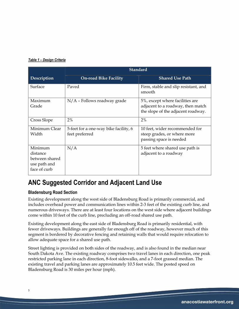
Design of a future bicycle and pedestrian connection to Fort Lincoln and surrounding neighborhoods may be governed by different design standards, depending on whether the proposed facility is an on-road bike-lane or an off-road shared use path. The design requirements for on-road facilities are provided in the American Association of State Highway and Transportation Officials (AASHTO) 2012 Guide for the Development of Bicycle Facilities (Bike Guide). Shared use paths must comply with the US Access Board 2011 Advanced Notice of Proposed Rulemaking (ANPRM) on Accessibility Guideline for Shared Use Paths in addition to the AASHTO Bike Guide. A summary of pertinent requirements is shown in Table 1.
Surface Paved Firm, stable and slip resistant, and smooth
Maximum Grade
N/A – Follows roadway grade 5%, except where facilities are adjacent to a roadway, then match the slope of the adjacent roadway.
Cross Slope 2% 2%
Minimum Clear Width
5-feet for a one-way bike facility, 6 feet preferred
10 feet, wider recommended for steep grades, or where more passing space is needed
Minimum distance between shared use path and face of curb
N/A 5 feet where shared use path is adjacent to a roadway
ANC Suggested Corridor and Adjacent Land Use
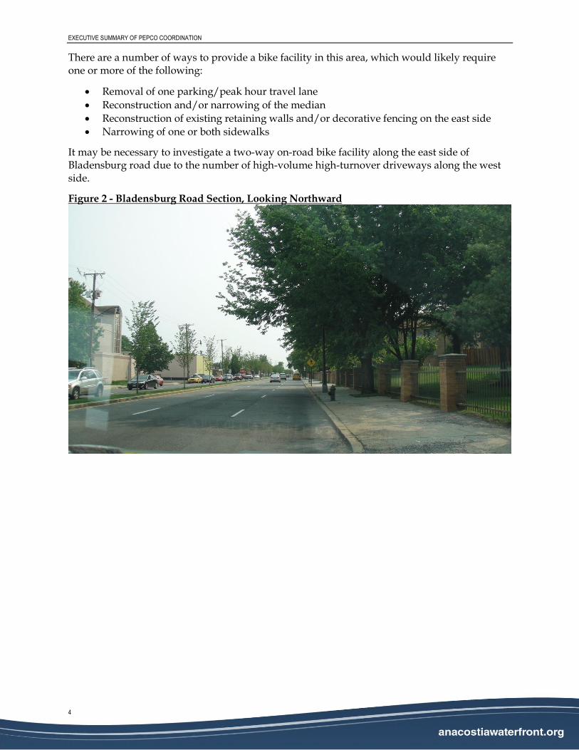
Bladensburg Road Section
Existing development along the west side of Bladensburg Road is primarily commercial, and includes overhead power and communication lines within 2-3 feet of the existing curb line, and numerous driveways. There are at least four locations on the west side where adjacent buildings come within 10 feet of the curb line, precluding an off-road shared use path.
Existing development along the east side of Bladensburg Road is primarily residential, with fewer driveways. Buildings are generally far enough off of the roadway, however much of this segment is bordered by decorative fencing and retaining walls that would require relocation to allow adequate space for a shared use path.
Street lighting is provided on both sides of the roadway, and is also found in the median near South Dakota Ave. The existing roadway comprises two travel lanes in each direction, one peak restricted parking lane in each direction, 8-foot sidewalks, and a 7-foot grassed median. The existing travel and parking lanes are approximately 10.5 feet wide. The posted speed on Bladensburg Road is 30 miles per hour (mph).
EXECUTIVE SUMMARY OF PEPCO COORDINATION
4
There are a number of ways to provide a bike facility in this area, which would likely require one or more of the following:
Removal of one parking/peak hour travel lane
Reconstruction and/or narrowing of the median
Reconstruction of existing retaining walls and/or decorative fencing on the east side
Narrowing of one or both sidewalks
It may be necessary to investigate a two-way on-road bike facility along the east side of Bladensburg road due to the number of high-volume high-turnover driveways along the west side.
This section of the study alignment is fairly open, and already contains both a sidewalk and a small (6-foot wide) paved path along the south side of Fort Lincoln Drive within Fort Lincoln Park, to the point where the ANC’s requested alignment enters the Pepco corridor. The south side of the roadway is bounded by Fort Lincoln Park, and the north by the Fort Lincoln Cemetery in Maryland.
Portions of the existing paved path have been covered over by landscaping, but it would be relatively easy to widen the trail and reconstruct the portions that have been covered over to provide a continuous off-road facility in this area. A roadway crossing on Fort Lincoln Dr. would be required for access to the Pepco Corridor, and design of this crossing must be carefully considered to ensure that users are visible to drivers on Fort Lincoln Dr.
Figure 3 - Fort Lincoln Drive Section, Looking South
EXECUTIVE SUMMARY OF PEPCO COORDINATION
6
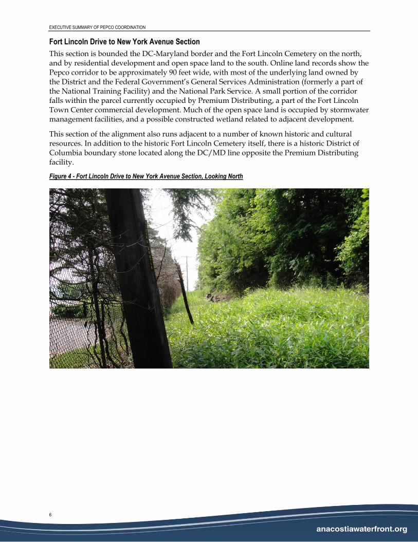
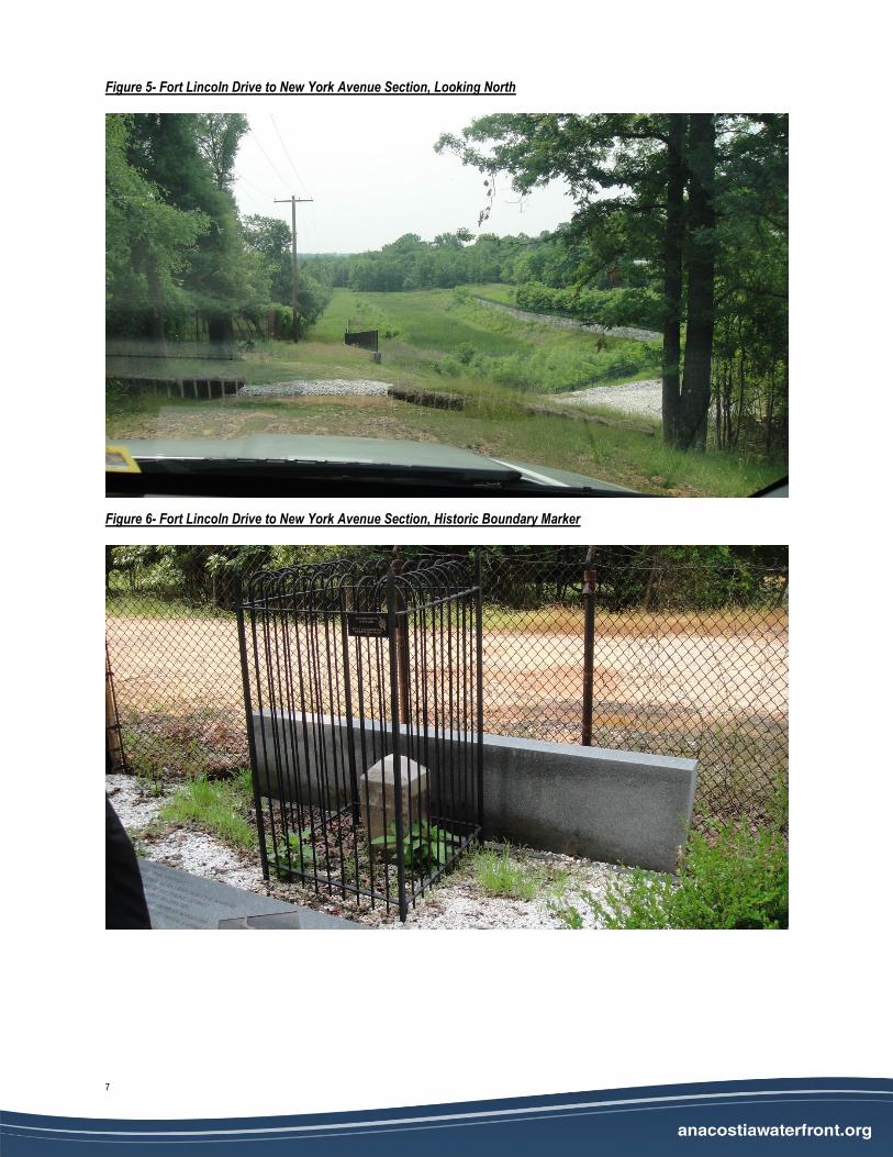
Fort Lincoln Drive to New York Avenue Section
This section is bounded the DC-Maryland border and the Fort Lincoln Cemetery on the north, and by residential development and open space land to the south. Online land records show the Pepco corridor to be approximately 90 feet wide, with most of the underlying land owned by the District and the Federal Government’s General Services Administration (formerly a part of the National Training Facility) and the National Park Service. A small portion of the corridor falls within the parcel currently occupied by Premium Distributing, a part of the Fort Lincoln Town Center commercial development. Much of the open space land is occupied by stormwater management facilities, and a possible constructed wetland related to adjacent development.
This section of the alignment also runs adjacent to a number of known historic and cultural resources. In addition to the historic Fort Lincoln Cemetery itself, there is a historic District of Columbia boundary stone located along the DC/MD line opposite the Premium Distributing facility.
Figure 4 - Fort Lincoln Drive to New York Avenue Section, Looking North
7
Figure 5- Fort Lincoln Drive to New York Avenue Section, Looking North
Figure 6- Fort Lincoln Drive to New York Avenue Section, Historic Boundary Marker
EXECUTIVE SUMMARY OF PEPCO COORDINATION
8
New York Avenue Crossing
This section traverses lands owned by District and the GSA on the west side, and the National Park Service on both sides of the Anacostia River, and makes use of the existing New York Avenue Bridge over the Anacostia. The existing bridge is approximately 95 feet wide, with three 11-foot travel lanes in each direction, separated by a center barrier. The outside shoulders are 8 feet wide, and inside shoulders are minimal. New York Avenue is considered a high-speed roadway, with a posted speed of 45 mph.
To provide a protected bike facility along the north side of the New York Ave. Bridge, the bridge would require widening to provide space for the bike facility and required traffic barriers and maintain minimum clearances and shoulder widths for vehicular travel lanes. Widening of the bridge is discussed under Structural Considerations, below.
The study alignment would connect to an on-water heavy-duty boardwalk currently being constructed as a part of the Kenilworth Trail Segment of the Anacostia Riverwalk Trail, and will likely require additional structural work to accommodate the difference in vertical elevation between the bridge surface and the boardwalk.
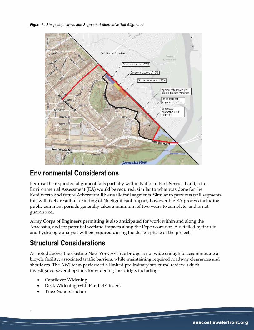
Topography
Topography at either end of the study alignment, along Bladensburg Road and near New York Ave. is relatively flat, and is not expected to cause difficulty with design of bike facilities. Of more concern is the area along the Pepco corridor. Approximately 1,700 feet, or 1/3 of a mile, of the alignment between Fort Lincoln Drive and New York Ave has grades in excess of 7%, and about half of that length exceeds 13%. The grades would need to be flattened in order to comply with Americans with Disabilities Act guidelines and the design criteria listed above. Using the steepest allowable grade, 5%, this would result in the need to construct retaining walls on one or both sides of the trail in excess of 50 feet high.
For this reason, an alternative alignment along roads within the Fort Lincoln Development is suggested. The steep slope areas and alternative alignment (depicted with a black line) are shown in Figure 7 below.
9
Figure 7 - Steep slope areas and Suggested Alternative Tail Alignment
Environmental Considerations
Because the requested alignment falls partially within National Park Service Land, a full Environmental Assessment (EA) would be required, similar to what was done for the Kenilworth and future Arboretum Riverwalk trail segments. Similar to previous trail segments, this will likely result in a Finding of No Significant Impact, however the EA process including public comment periods generally takes a minimum of two years to complete, and is not guaranteed.
Army Corps of Engineers permitting is also anticipated for work within and along the Anacostia, and for potential wetland impacts along the Pepco corridor. A detailed hydraulic and hydrologic analysis will be required during the design phase of the project.
Structural Considerations
As noted above, the existing New York Avenue bridge is not wide enough to accommodate a bicycle facility, associated traffic barriers, while maintaining required roadway clearances and shoulders. The AWI team performed a limited preliminary structural review, which investigated several options for widening the bridge, including:
Cantilever Widening
Deck Widening With Parallel Girders
Truss Superstructure
EXECUTIVE SUMMARY OF PEPCO COORDINATION
10
All of these widening methods are similar in cost, though only a cantilever widening could be accomplished without constructing at least one bridge pier within the river. A summary of the preliminary investigation, along with pros and cons of each widening option is included in Attachment A.
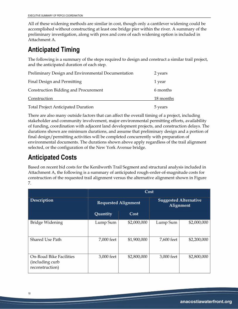
Anticipated Timing
The following is a summary of the steps required to design and construct a similar trail project, and the anticipated duration of each step.
Preliminary Design and Environmental Documentation 2 years
Final Design and Permitting 1 year
Construction Bidding and Procurement 6 months
Construction 18 months
Total Project Anticipated Duration 5 years
There are also many outside factors that can affect the overall timing of a project, including stakeholder and community involvement, major environmental permitting efforts, availability of funding, coordination with adjacent land development projects, and construction delays. The durations shown are minimum durations, and assume that preliminary design and a portion of final design/permitting activities will be completed concurrently with preparation of environmental documents. The durations shown above apply regardless of the trail alignment selected, or the configuration of the New York Avenue bridge.
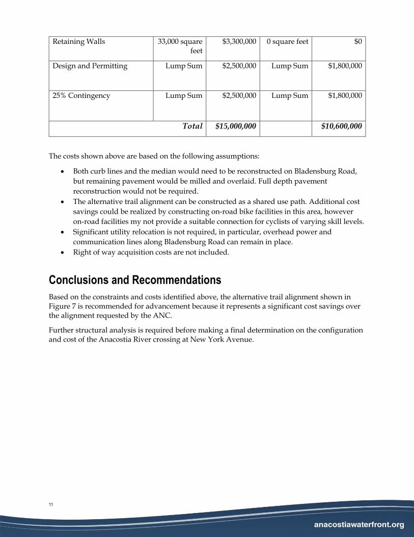
Anticipated Costs
Based on recent bid costs for the Kenilworth Trail Segment and structural analysis included in Attachment A, the following is a summary of anticipated rough-order-of-magnitude costs for construction of the requested trail alignment versus the alternative alignment shown in Figure 7.
Cost
Description Requested Alignment
Suggested Alternative Alignment
Quantity Cost
Bridge Widening Lump Sum
$2,000,000
Lump Sum
$2,000,000
Shared Use Path 7,000 feet
$1,900,000
7,600 feet
$2,200,000
On-Road Bike Facilities (including curb reconstruction)
3,000 feet
$2,800,000
3,000 feet
$2,800,000
11
Retaining Walls 33,000 square feet
$3,300,000 0 square feet $0
Design and Permitting Lump Sum
$2,500,000
Lump Sum
$1,800,000
25% Contingency Lump Sum
$2,500,000
Lump Sum
$1,800,000
Total $15,000,000 $10,600,000
The costs shown above are based on the following assumptions:
Both curb lines and the median would need to be reconstructed on Bladensburg Road,
but remaining pavement would be milled and overlaid. Full depth pavement
reconstruction would not be required.
The alternative trail alignment can be constructed as a shared use path. Additional cost
savings could be realized by constructing on-road bike facilities in this area, however
on-road facilities my not provide a suitable connection for cyclists of varying skill levels.
Significant utility relocation is not required, in particular, overhead power and
communication lines along Bladensburg Road can remain in place.
Right of way acquisition costs are not included.
Conclusions and Recommendations
Based on the constraints and costs identified above, the alternative trail alignment shown in Figure 7 is recommended for advancement because it represents a significant cost savings over the alignment requested by the ANC.
Further structural analysis is required before making a final determination on the configuration and cost of the Anacostia River crossing at New York Avenue.
EXECUTIVE SUMMARY OF PEPCO COORDINATION
12
Attachment A – Limited Preliminary Structural Analysis
13
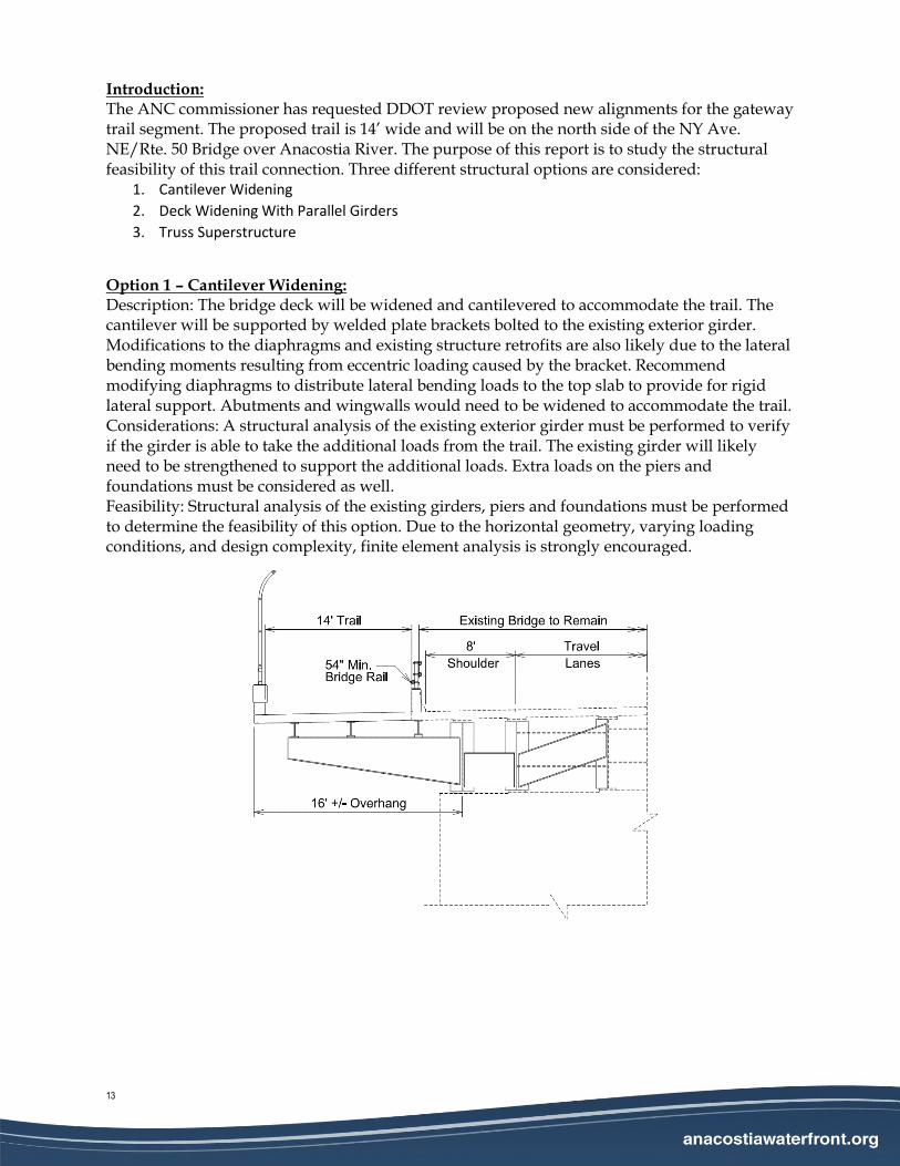
Introduction: The ANC commissioner has requested DDOT review proposed new alignments for the gateway trail segment. The proposed trail is 14’ wide and will be on the north side of the NY Ave. NE/Rte. 50 Bridge over Anacostia River. The purpose of this report is to study the structural feasibility of this trail connection. Three different structural options are considered:
1. Cantilever Widening
2. Deck Widening With Parallel Girders
3. Truss Superstructure
Option 1 – Cantilever Widening: Description: The bridge deck will be widened and cantilevered to accommodate the trail. The cantilever will be supported by welded plate brackets bolted to the existing exterior girder. Modifications to the diaphragms and existing structure retrofits are also likely due to the lateral bending moments resulting from eccentric loading caused by the bracket. Recommend modifying diaphragms to distribute lateral bending loads to the top slab to provide for rigid lateral support. Abutments and wingwalls would need to be widened to accommodate the trail. Considerations: A structural analysis of the existing exterior girder must be performed to verify if the girder is able to take the additional loads from the trail. The existing girder will likely need to be strengthened to support the additional loads. Extra loads on the piers and foundations must be considered as well. Feasibility: Structural analysis of the existing girders, piers and foundations must be performed to determine the feasibility of this option. Due to the horizontal geometry, varying loading conditions, and design complexity, finite element analysis is strongly encouraged.
EXECUTIVE SUMMARY OF PEPCO COORDINATION
14
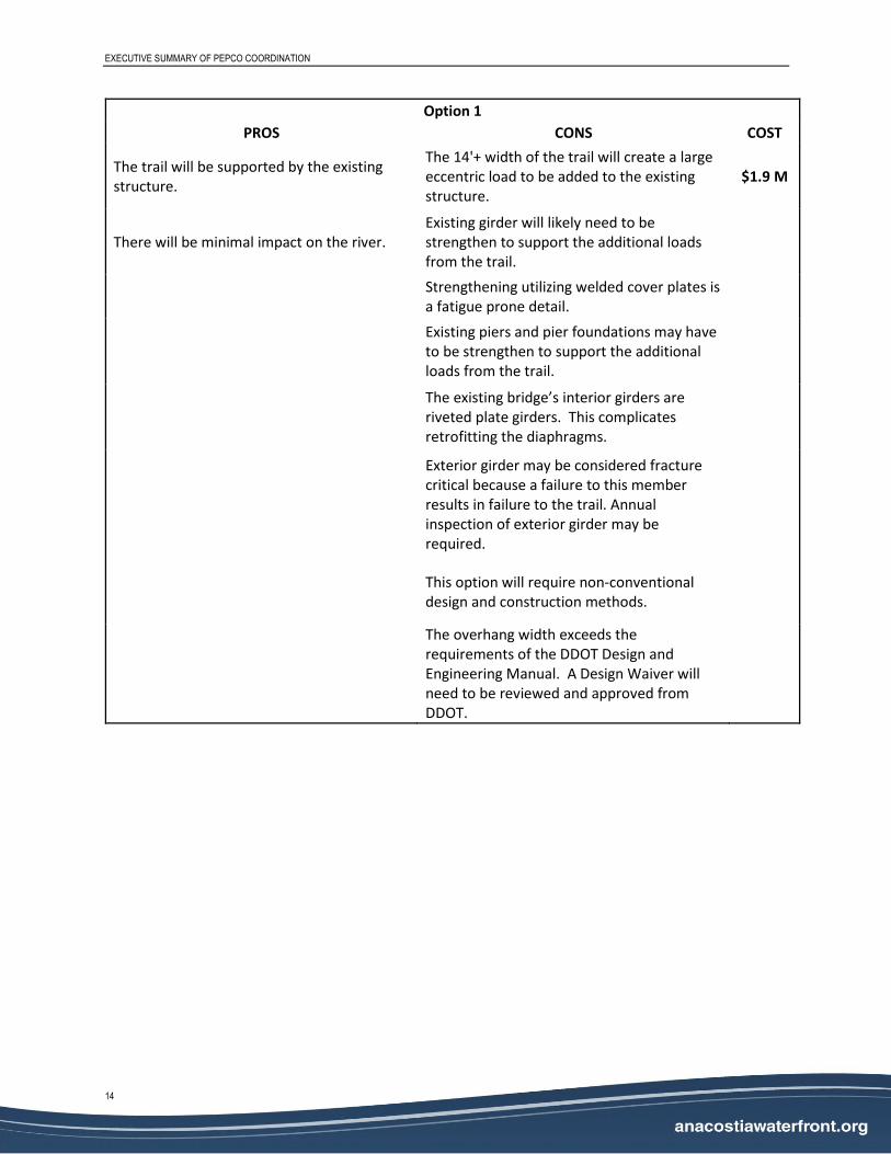
Option 1
PROS CONS COST
The trail will be supported by the existing structure.
The 14'+ width of the trail will create a large eccentric load to be added to the existing structure.
$1.9 M
There will be minimal impact on the river. Existing girder will likely need to be strengthen to support the additional loads from the trail.
Strengthening utilizing welded cover plates is a fatigue prone detail.
Existing piers and pier foundations may have to be strengthen to support the additional loads from the trail.
The existing bridge’s interior girders are riveted plate girders. This complicates retrofitting the diaphragms.
Exterior girder may be considered fracture critical because a failure to this member results in failure to the trail. Annual inspection of exterior girder may be required.
This option will require non-conventional design and construction methods.
The overhang width exceeds the requirements of the DDOT Design and Engineering Manual. A Design Waiver will need to be reviewed and approved from DDOT.
15
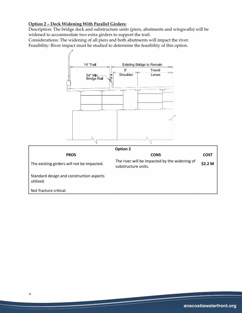
Option 2 – Deck Widening With Parallel Girders: Description: The bridge deck and substructure units (piers, abutments and wingwalls) will be widened to accommodate two extra girders to support the trail. Considerations: The widening of all piers and both abutments will impact the river. Feasibility: River impact must be studied to determine the feasibility of this option.
Option 2
PROS CONS COST
The existing girders will not be impacted. The river will be impacted by the widening of substructure units.
$2.2 M
Standard design and construction aspects utilized.
Not fracture critical.
EXECUTIVE SUMMARY OF PEPCO COORDINATION
16
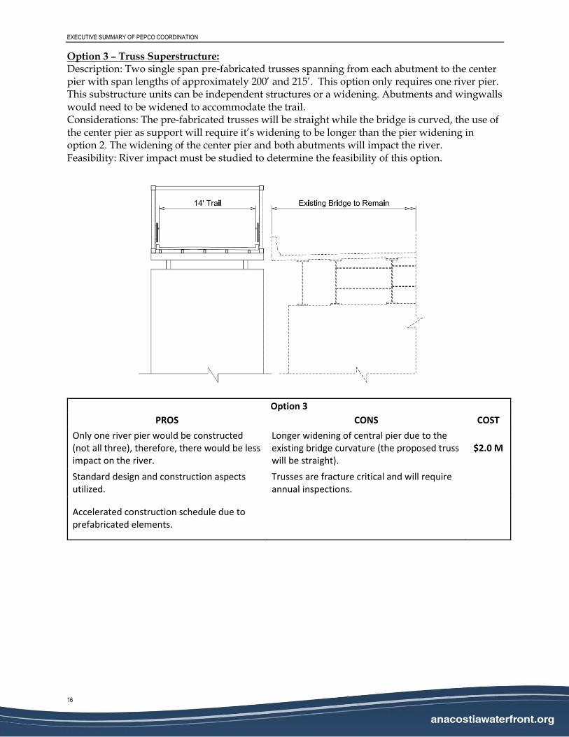
Option 3 – Truss Superstructure: Description: Two single span pre-fabricated trusses spanning from each abutment to the center pier with span lengths of approximately 200’ and 215’. This option only requires one river pier. This substructure units can be independent structures or a widening. Abutments and wingwalls would need to be widened to accommodate the trail. Considerations: The pre-fabricated trusses will be straight while the bridge is curved, the use of the center pier as support will require it’s widening to be longer than the pier widening in option 2. The widening of the center pier and both abutments will impact the river. Feasibility: River impact must be studied to determine the feasibility of this option.
Option 3
PROS CONS COST
Only one river pier would be constructed (not all three), therefore, there would be less impact on the river.
Longer widening of central pier due to the existing bridge curvature (the proposed truss will be straight).
$2.0 M
Standard design and construction aspects utilized.
Trusses are fracture critical and will require annual inspections.
Accelerated construction schedule due to prefabricated elements.