19
TECHNICAL REPORT A-014/2000 Accident suffered by the aircraft MOONEY M20K, registration G-GTPL, in Font de Corts, Montseny Massif, municipal district of Gualba (Barcelona), on 27 May 2000

TECHNICALREPORT
A-014/2000
Accident suffered by theaircraft MOONEY M20K,
registration G-GTPL,in Font de Corts,
Montseny Massif,municipal district ofGualba (Barcelona),
on 27 May 2000

Technical report
A-014/2000
Accident suffered by the aircraft MOONEYM20K, registration G-GTPL, in Font de Corts,
Montseny Massif, municipal district of Gualba(Barcelona), on 27 May 2000
MINISTERIODE FOMENTO
SECRETARÍA GENERAL DETRANSPORTES
COMISIÓN DE INVESTIGACIÓNDE ACCIDENTES E INCIDENTESDE AVIACIÓN CIVIL

Edita: Centro de PublicacionesSecretaría General TécnicaMinisterio de Fomento ©
NIPO: 161-03-011-0Depósito legal: M. 23.129-2003Imprime: Centro de Publicaciones
Diseño cubierta: Carmen G. Ayala
COMISIÓN DE INVESTIGACIÓN DE ACCIDENTES E INCIDENTES DE AVIACIÓN CIVIL
Tel.: +34 91 597 89 60 E-mail: [email protected] C/ Fruela, 6Fax: +34 91 463 55 35 http://www.mfom.es/ciaiac 28011 Madrid (España)

F o r e w o r d
This report is a technical document that reflects the point of view of the CivilAviation Accident and Incident Investigation Commission (CIAIAC) regardingthe circumstances of the accident and its causes and consequences.
In accordance with the provisions of Law 21/2003 and Annex 13 to the Con-vention on International Civil Aviation, the investigation has exclusively atechnical nature, without having been targeted at the declaration or assign-ment of blame or liability. The investigation has been carried out withouthaving necessarily used legal evidence procedures and with no other basicaim than preventing future accidents.
Consequently, any use of this report for purposes other than that of preven-ting future accidents may lead to erroneous conclusions or interpretations.
This report has originally been issued in Spanish language. This English trans-lation is provided for information purposes only.

v
Technical report A-014/2000
T a b l e o f c o n t e n t s
Abbreviations ................................................................................................................................ vi
1. Factual information ............................................................................................................... 1
1.1. History of the flight ........................................................................................................ 11.2. Injuries to persons .......................................................................................................... 21.3. Damage to aircraft ......................................................................................................... 21.4. Other damage ................................................................................................................ 21.5. Personnel information .................................................................................................... 2
1.5.1. Pilot ................................................................................................................... 21.6. Aircraft information ........................................................................................................ 2
1.6.1. Identification ..................................................................................................... 31.6.2. Certificate of airworthiness ............................................................................... 31.6.3. Maintenance log ............................................................................................... 31.6.4. Engine ............................................................................................................... 3
1.7. Meteorological information ............................................................................................ 41.8. Aids to navigation .......................................................................................................... 41.9. Communications ............................................................................................................ 41.10. Wreckage and impact information ................................................................................. 51.11. Medical and pathological information ............................................................................ 51.12. Survival aspects .............................................................................................................. 51.13. Tests and research ......................................................................................................... 5
1.13.1. Radar contact .................................................................................................. 51.13.2. Planning of the flight ...................................................................................... 6
1.14. Additional information ................................................................................................... 6
2. Analysis .................................................................................................................................. 7
2.1. Progress of the flight ..................................................................................................... 72.2. Considerations on the accident ...................................................................................... 72.3. Availability of the meteorological information ................................................................ 8
3. Conclusion .............................................................................................................................. 9
3.1. Findings .......................................................................................................................... 93.2. Causes ........................................................................................................................... 9
4. Safety recommendations ...................................................................................................... 11
Appendices .................................................................................................................................... 13
Appendix A. Radar track ......................................................................................................... 15
Technical report A-014/2000
vi
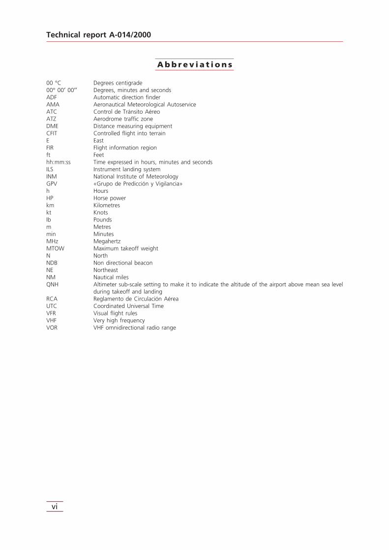
A b b r e v i a t i o n s
00 °C Degrees centigrade00° 00′ 00′′ Degrees, minutes and secondsADF Automatic direction finderAMA Aeronautical Meteorological AutoserviceATC Control de Tránsito AéreoATZ Aerodrome traffic zoneDME Distance measuring equipmentCFIT Controlled flight into terrainE EastFIR Flight information regionft Feethh:mm:ss Time expressed in hours, minutes and secondsILS Instrument landing systemINM National Institute of MeteorologyGPV «Grupo de Predicción y Vigilancia»h HoursHP Horse powerkm Kilometreskt KnotsIb Poundsm Metresmin MinutesMHz MegahertzMTOW Maximum takeoff weightN NorthNDB Non directional beaconNE NortheastNM Nautical milesQNH Altimeter sub-scale setting to make it to indicate the altitude of the airport above mean sea level
during takeoff and landingRCA Reglamento de Circulación AéreaUTC Coordinated Universal TimeVFR Visual flight rulesVHF Very high frequencyVOR VHF omnidirectional radio range

1. FACTUAL INFORMATION
1.1. History of the flight
According to the Flight Plan submitted, on the day of the accident, 27 May 2000, theaircraft of the make Mooney, model M20K, registration G-GTPL, planned to make a pri-vate flight under VFR rules from the airport of Murcia/San Javier to that of Perpignan(France), as a first stage towards its final destination in the United Kingdom. Accordingto the Flight Plan, the planned cruising speed was 150 kt, flight level corresponding toVFR, estimated duration of the flight two and a half hours, and a fuel load for five hoursof endurance.
The aircraft took off from the airport of Murcia/San Javier at 8:32 h1 with the pilot asthe sole occupant and meteorological conditions suitable for VFR flying.
At 10:25:26 h the pilot established contact with the control tower of Sabadell airport,indicating that he was leaving the ATZ (aerodrome traffic zone) of Sabadell by thenorth-east (NE) at a height of 3,500 feet QNH and reporting that he was preparing todescend in order to maintain visual contact with the ground.
This was the last communication with the aircraft, although the radio operator of theSabadell control tower believes he recalls receiving a call from the aircraft five minuteslater but without understanding it: consequently he instructed the pilot to contact himon 125.5 MHz but obtained no reply.
The last radar contact with the aircraft is available, at 10:37:45 h. This contact situatesit in radial 231 of the VOR of Gerona, at a distance of approximately 29.5 km (15.9 NM),at a flying height of 3,000 feet and climbing, according to the radar indication.
Subsequently, as the pre-established time had passed without news of the aircraft, Per-pignan Airport activated alert procedures and an air search was commenced for the air-craft.
The wreckage was located the following morning in the Montseny Massif, at latitude41° 45′ 55′′ N and longitude 02° 29′ 13′′ E, in Font de Corts, municipal district of Gual-ba (Barcelona).
The aircraft had struck the ground in a mountainous zone of difficult access, situatedat a height of 950 metres (3,117 feet). The aircraft was completely destroyed and itsoccupant was found dead.
It is estimated that the accident occurred at around 10:40 h.
1
Technical report A-014/2000
1 Time reference in this report is Coordinated Universal Time (UTC) unless otherwise stated.
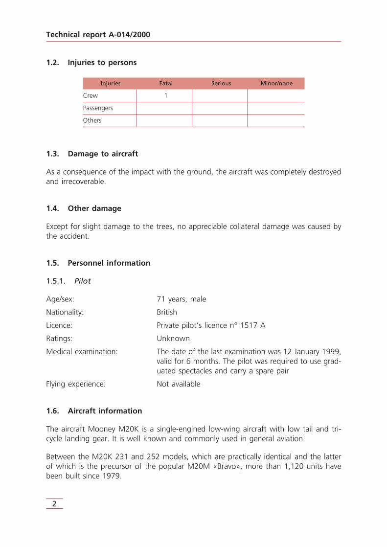
1.2. Injuries to persons
Injuries Fatal Serious Minor/none
Crew 1
Passengers
Others
1.3. Damage to aircraft
As a consequence of the impact with the ground, the aircraft was completely destroyedand irrecoverable.
1.4. Other damage
Except for slight damage to the trees, no appreciable collateral damage was caused bythe accident.
1.5. Personnel information
1.5.1. Pilot
Age/sex: 71 years, male
Nationality: British
Licence: Private pilot’s licence n° 1517 A
Ratings: Unknown
Medical examination: The date of the last examination was 12 January 1999,valid for 6 months. The pilot was required to use grad-uated spectacles and carry a spare pair
Flying experience: Not available
1.6. Aircraft information
The aircraft Mooney M20K is a single-engined low-wing aircraft with low tail and tri-cycle landing gear. It is well known and commonly used in general aviation.
Between the M20K 231 and 252 models, which are practically identical and the latterof which is the precursor of the popular M20M «Bravo», more than 1,120 units havebeen built since 1979.
Technical report A-014/2000
2

Initially the aircraft in question, registration G-GTPL, was equipped with a McCauley 2A2HC 216 propeller, but on 7 June 1998 it was refitted with a Hartzell PHC-J3YF-1RF/F7663A-2R propeller.
1.6.1. Airframe
Make: Mooney Aircraft Corp.
Model: M20K 231
Serial number: 25-0301
Registration: G-GTPL
MTOW: 2,900 lb, equivalent to 1,315 kg
Owner: Private
Operator: Private
1.6.2. Certificate of airworthiness
Number: 007455/002
Type: Private
Date of issue: 28-06-1998
Date of expiry: 27-06-2001
1.6.3. Maintenance log
Total flying hours: 1,239 hours, 5 min as of 13-05-2000
Last annual inspection: 09-07-1999
Hours since last annual insp.: 34 hours, 40 min as of 13-05-2000
1.6.4. Engine
Make: Continental
Model: TS10-360-GB1
Power: 210 HP
Serial number: 309319
Last annual inspection: 09-07-1999
3
Technical report A-014/2000

1.7. Meteorological information
The meteorological conditions in the airport of origin were suitable for VFR flying at themoment of departure.
The forecasts for low levels (up to FL150) for the FIR of Barcelona between 09:00 and15:00 h announced an anticyclone of 1,020 hectopascals, weakening, with isolatedstorms over the Balearic Islands, mountains obscured by clouds over the Pyrenees andwinds of 1 to 8 kt between levels FL20 and FL50.
However, these conditions gradually worsened during the course of the flight, and inthe communication with the aircraft at 10:25:26 h the pilot reported that his flight lev-el was 3,500 feet and he was preparing to descend to maintain visual contact with theground.
The meteorological information of the Montseny Meteorological Observatory, close tothe accident site, at 7:00 h and 12:00 h, showed wind 260°/10-18 kts, fog, tempera-ture 9-9.4 °C, 100% humidity and rain at the observation times, with precipitation of1.2 litres in this period.
As has been stated, the accident occurred at a height of 950 m (3,117 feet).
1.8. Aids to navigation
The Aircraft Station Licence indicates the installation of a King KR87 ADF unit, a KingKNS80 DME-Area Navigator unit, a King KN53 VOR/ILS unit, a King KMA24 beaconreceiver and a King KT76A ATC transponder with mode C (height) incorporated. TheLicence also includes an RCA Weather Scout 1 weather radar unit.
1.9. Communications
The Aircraft Station Licence includes the installation of two King KY197 VHF communi-cations units.
Although this equipment was used by the pilot during both take-off and flight, accord-ing to the communication with the control tower of Sabadell airport described earlier,no help or emergency call was detected from the aircraft, although, as has been said,the Sabadell radio operator believes he recalls receiving a later call from the aircraftwhich he did not understand, as a result of which he requested the pilot to change tofrequency 125.5 MHz, but without results.
Technical report A-014/2000
4
1.10. Wreckage and impact information
The wreckage of the aircraft was found grouped together in a radius of approximately25 metres, tangled with the vegetation, the fuselage being held up by the trees and thenose embedded in some rocks in which the impact of the aircraft was located. Theengine was displaced to the right and the propeller two metres in front of the aircraft,at a higher level, with one of its blades embedded in the ground.
The right wing had broken off the fuselage, while the left wing, although badly dam-aged, remained connected to it.
From the visual inspection of the distribution of the wreckage and the traces observedin the vegetation surrounding the accident site, it can be deduced that the aircraftscraped the tops of the trees in a climbing direction and its right wing struck a tree larg-er than the rest. This impact caused the wing to break off and the aircraft to changedirection abruptly, the nose colliding with the rock and the propeller breaking and split-ting off (see photographs of the wreckage in Appendix A).
1.11. Medical and pathological information
The occupant of the aircraft died as a result of the deceleration traumatism he sufferedin the impact of the aircraft with the ground.
1.12. Survival aspects
In view of the characteristics of the accident and of the impact with the ground, thesole occupant of the aircraft had practically no possibility of survival.
1.13. Tests and research
1.13.1. Radar contact
As stated earlier, only one radar contact with the aircraft is registered, made at10:37:45 h.
In this contact, the approximate situation of the aircraft was in radial 231 of the VORof Gerona, at a distance of 29.5 km (15.9 NM), 3,000 feet height and climbing, with aregistered radar speed of 80 kt (see figure in Appendix A).
5
Technical report A-014/2000

1.13.2. Planning of the flight
According to the information compiled from the meteorological office of Murcia Air-port, there is no record of the pilot reporting to this office to request the meteorolog-ical information that would enable him to plan the flight fully and appropriately.
In general, in airports associated with military bases, the meteorological offices are sit-uated in the zone under the control of the military authorities. Civilian crews needauthorisation to enter these zones. The formalities for obtaining this permission have tobe carried out in advance.
1.14. Additional information
Regarding the information provided in the last paragraph of Section 1.13.2, it is neces-sary to mention that, in year 2004, the meteorological officces of the military Air Basesopen to civil air traffic are directly connected with the Operations Offices of the civilfacilities of the Base. Therefore, civil pilots may access the relevant weather informationto prepare their flights by phone, fax and remote terminals relaying the information ofthe terminals at the Meteorological Offices.
On the other hand, the National Institute of Meteorology (INM), which is the providerof meteorological services to the aviation in Spain, has developed a computer tool called«Aeronautical Meteorological Autoservice» (AMA) through which any aviation user mayaccess by internet all the necessary information for pre-flight purposes by internet. Thistool is in service since year 2003. In addition, the INM has several regional «Grupos dePredicción y Vigilancia» (GPV) in Spain, and any information not available through AMAmay be consulted to them by phone.
Technical report A-014/2000
6
2. ANALYSIS
2.1. Progress of the flight
According to its Flight Plan, the aircraft make Mooney, model M20K, registration G-GTPL, took off from the Airport of Murcia-San Javier with one sole occupant at around8:30 h on 27 May 2000, to carry out a general non-commercial VFR flight to the air-port of Perpignan (France). As indicated above, there is no record of the pilot collectingmeteorological information in order to prepare the Flight Plan.
The planned speed was 150 kt, flight level corresponding to VFR and estimated dura-tion of the flight two and a half hours. The endurance of the aircraft, according to itsFlight Plan, was five hours.
The only communication from the aircraft registered during the flight corresponds to10:25:26 h with the control tower of Sabadell airport. In this contact, the pilot indicat-ed that he was leaving the ATZ of Sabadell by the NE at a height of 3,500 feet QNHand was about to descend to maintain visual contact with the ground.
Subsequently, in addition to a possible call which the operator of the control towerof Sabadell airport believes he recalls but did not understand, there is a radar con-tact at 10:37:45 h, situating the aircraft at some 29.5 km (15.9 NM) from the VORof Gerona in radial 231 and climbing from a height of 3,000 feet at a speed of80 kt.
The wreckage of the aircraft, completely destroyed, and the dead body of the pilot werefound the following morning in the Montseny Massif at latitude 41° 45′ 55′′ N and lon-gitude 02° 29′ 13′′ E, in a mountainous zone of difficult access, situated at a height of950 m (3,117 feet).
2.2. Considerations on the accident
Given the position in which the wreckage was found, the position indicated by the pilotin his last registered radio communication (leaving the ATZ of Sabadell by the NE), theposition defined in the radar contact and the speed of 80 kt and climbing indicated inthis contact, it is estimated that the accident must have occurred a few minutes after10:37 h.
With this hypothesis, a total failure of communications in the time between the last con-nection and the accident is considered very improbable, as a result of which, as thereis no evidence of any attempt at emergency communication from the aircraft, it isassumed that no failure became evident to the pilot during this time.
7
Technical report A-014/2000

The evolution of the flight, as stated earlier, suggests that the operation of the aircraftwas a descent begun from 3,500 feet, according to the radio communication, enteringa mountainous zone with fog, according to the information of the Montseny Meteoro-logical Observatory, and therefore with low visibility. The meteorological phenomenonis considered local and unpredictable, since the forecasts, which in any case wereunknown to the pilot, indicated only mountains obscured by clouds over the Pyreneesabove 6,000 feet.
Either in response to the navigation information or on seeing the height of the groundover which he was flying, with mountains and zones higher than 3,000 feet, the pilotbegan a climbing manoeuvre, as is detected in the radar contact and the investigationcarried out at the accident site, which, possibly, he was unable to complete, scrapingthe tops of the trees and striking the ground at a height of 950 m (3,117 feet).
This accident can be catalogued among those known as the CFIT type (Controlled FlightInto Terrain), which occur when an otherwise airworthy aircraft is unintentionally flowninto the ground under the control of the crew.
2.3. Availability of the meteorological information
There is no evidence that the pilot collected the weather information necessary for pre-flight planning. It is possible that the pilot only asked for the information available inthe Operations Office located in the civil zone of the airport, or maybe that he did notask for any weather information. In any case, as mentioned in section 1.14, the avail-able means to access meteorological information in the military air bases open to civiltraffic in Spain by the end of 2004 have increased with respect to the ones available atthe time of the accident, and it is considered that those means allow an adequate accessto the data necessary to plan the flight.
Technical report A-014/2000
8

3. CONCLUSION
3.1. Findings
— The pilot held a valid licence for the type of flight he was carrying out. However, itis considered that it was not in force, because the period of validity of the medicalexamination had been exceeded by ten months and 15 days on the date of the acci-dent.
— The aircraft held a current Airworthiness Certificate on the date of the accident.— The flight had been commenced in meteorological conditions suitable for flying
under VFR rules.— The corresponding Flight Plan had been prepared and communicated via the ordi-
nary channels.— There is no record of the pilot requesting meteorological information on the route
in planning the flight.— At Murcia Airport, which has joint military and civilian use, civilian crews require
authorisation to enter the meteorological office.— In a descent from 3,500 feet to maintain visual contact with the ground, the aircraft
entered a mountainous area with fog, and therefore with low visibility, striking theground at a height of 950 metres (3,117 feet) and causing the complete destruc-tion of the aircraft and the death of the occupant.
3.2. Causes
It is considered that the accident was of the CFIT type (Controlled Flight Into Terrain),caused by the aircraft descending from a height of 3,500 feet QNH to maintain visualcontact with the ground and flying into fog in a mountainous area. The accidentoccurred at a height of 950 m (3,117 feet), following a radar contact which indicatedthat the aircraft was climbing from 3000 feet at a speed of 80 kt.
9
Technical report A-014/2000

4. SAFETY RECOMMENDATIONS
None.
11
Technical report A-014/2000

13
Technical report A-014/2000
APPENDICES

15
Technical report A-014/2000
APPENDIX ARadar track

Radar track. Last presentation
17
Technical report A-014/2000


