Tectonic, climatic and hydrothermal control on sedimentation and water chemistry of northern Lake Malawi (Nyasa), Tanzania Philippe Branchu a,1 , Laurent Bergonzini b,2 , Damien Delvaux c, * , Marc De Batist d,3 , Vladimir Golubev e,4 , Marc Benedetti f,5 , Jean Klerkx g a CEREGE, UMR 6635, Europo ˆle Me ´ diterrane ´en de l’Arbois, BP 80, 13545 Aix en Provence cedex 04, France b UMR-CNRS 8148 IDES, Universite ´ Paris-Sud, Orsay, France c Royal Museum for Central Africa, Department of Geology and Mineralogy, Leuvensesteenweg 13, B-3080, Tervuren, Belgium d Renard Centre of Marine Geology, Universiteit Gent, Belgium e Institute of the Earth’s Crust, Irkutsk, Russia f Laboratoire de Ge ´ochimie des eaux, UMR CNRS 7047, Universite ´ Denis Diderot, Paris, France g International Bureau for Environmental Studies, Brussels, Belgium Received 27 April 2004; accepted 2 September 2005 Available online 15 November 2005 Abstract This paper presents a multi-disciplinary characterisation of processes that influence sedimentation and lake water chemistry in the northern part of the Lake Malawi (or Lake Nyasa), East Africa. This characterisation is based on geophysical (heat-flow), tectonic, hydrological, hydrochemical (major elements, stable isotopes) and sedimentological (seismic profiles, core mineralogy) studies of data acquired from 1990 to 1994 during the CASIMIR project (Comparative Analysis of Sedimentary Infill Mechanisms in Rifts). Sub-surface activity is expressed through seismic and volcanic activity, as well as elevated heat-flow values, both beneath the lake and the surrounding area; hydrothermal activity is observed in the watershed however it was not clearly identified in the sub-lacustrine envi- ronment. Relatively high heat-flow values (80–90 mW/m 2 ) and the chemical composition of hydrothermal fluids in hot springs suggest the presence of a magmatic body at depth. The influence of Quaternary tectonic activity on sedimentary dynamics and infilling is observed not only on land but also in the lake through high-resolution seismic profiles. The main feature is a general tilting of the Kyela Plain as shown by a shift in the river course. The Quaternary stacking pattern of seven sedimentary sequences identified on a grid of high-resolution seismic reflection profiles repre- sents a complete long-term lake-level cycle, from a lake lowstand at about 320 m below the present level to the present-day lake high- stand. The North-Kiwira and Songwe River delta systems, composed of a number of stacked lobes, were developed in response to the interplay between gradual lake-level rise, tectonic movement and sediment input. The river dynamics is also recorded in a short core by a mineralogical evolution probably due to a decrease of detrital inputs from the Songwe River in response to hydroclimatic changes. Such changes are very important as this northern part of the watershed is considered as a recharge zone for the entire lake. Sedimentological patterns (from shallow depth to about 240 m water depth) and hydrochemistry are both influenced by watershed characteristics (pedol- ogy, geology, vegetation, hydrology, climate, etc.) but also by lacustrine biological processes: diatom productivity in epilimnetic water and degradation or preservation in deeper waters. 1464-343X/$ - see front matter Ó 2005 Elsevier Ltd. All rights reserved. doi:10.1016/j.jafrearsci.2005.09.004 * Corresponding author. Tel.: +32 2 7695426; fax: +32 2 7695432. E-mail addresses: [email protected](P. Branchu), [email protected](L. Bergonzini), [email protected](D. Delvaux), [email protected](M. De Batist), [email protected](V. Golubev), [email protected](M. Benedetti), [email protected](J. Klerkx). 1 Present address: Centre GEOTOP-UQAM-McGill - CP 8888, succursale Centre-Ville, Montre ´al, Que ´., Canada H3C 3P8. Tel.: +1 514 495 4691; fax: +1 514 987 3635. 2 Fax: +33 1 6915 4917. 3 Fax: +32 9 264 4967. 4 Fax: +39 52 462 900. 5 Fax: +33 1 4427 8277. www.elsevier.com/locate/jafrearsci Journal of African Earth Sciences 43 (2005) 433–446
Transcript
www.elsevier.com/locate/jafrearsci
Journal of African Earth Sciences 43 (2005) 433–446
Tectonic, climatic and hydrothermal control on sedimentationand water chemistry of northern Lake Malawi (Nyasa), Tanzania
Philippe Branchu a,1, Laurent Bergonzini b,2, Damien Delvaux c,*, Marc De Batist d,3,Vladimir Golubev e,4, Marc Benedetti f,5, Jean Klerkx g
a CEREGE, UMR 6635, Europole Mediterraneen de l’Arbois, BP 80, 13545 Aix en Provence cedex 04, Franceb UMR-CNRS 8148 IDES, Universite Paris-Sud, Orsay, France
c Royal Museum for Central Africa, Department of Geology and Mineralogy, Leuvensesteenweg 13, B-3080, Tervuren, Belgiumd Renard Centre of Marine Geology, Universiteit Gent, Belgium
e Institute of the Earth’s Crust, Irkutsk, Russiaf Laboratoire de Geochimie des eaux, UMR CNRS 7047, Universite Denis Diderot, Paris, France
g International Bureau for Environmental Studies, Brussels, Belgium
Received 27 April 2004; accepted 2 September 2005Available online 15 November 2005
Abstract
This paper presents a multi-disciplinary characterisation of processes that influence sedimentation and lake water chemistry in thenorthern part of the Lake Malawi (or Lake Nyasa), East Africa. This characterisation is based on geophysical (heat-flow), tectonic,hydrological, hydrochemical (major elements, stable isotopes) and sedimentological (seismic profiles, core mineralogy) studies of dataacquired from 1990 to 1994 during the CASIMIR project (Comparative Analysis of Sedimentary Infill Mechanisms in Rifts).
Sub-surface activity is expressed through seismic and volcanic activity, as well as elevated heat-flow values, both beneath the lake andthe surrounding area; hydrothermal activity is observed in the watershed however it was not clearly identified in the sub-lacustrine envi-ronment. Relatively high heat-flow values (80–90 mW/m2) and the chemical composition of hydrothermal fluids in hot springs suggestthe presence of a magmatic body at depth.
The influence of Quaternary tectonic activity on sedimentary dynamics and infilling is observed not only on land but also in the lakethrough high-resolution seismic profiles. The main feature is a general tilting of the Kyela Plain as shown by a shift in the river course.The Quaternary stacking pattern of seven sedimentary sequences identified on a grid of high-resolution seismic reflection profiles repre-sents a complete long-term lake-level cycle, from a lake lowstand at about 320 m below the present level to the present-day lake high-stand. The North-Kiwira and Songwe River delta systems, composed of a number of stacked lobes, were developed in response to theinterplay between gradual lake-level rise, tectonic movement and sediment input. The river dynamics is also recorded in a short core by amineralogical evolution probably due to a decrease of detrital inputs from the Songwe River in response to hydroclimatic changes. Suchchanges are very important as this northern part of the watershed is considered as a recharge zone for the entire lake. Sedimentologicalpatterns (from shallow depth to about 240 m water depth) and hydrochemistry are both influenced by watershed characteristics (pedol-ogy, geology, vegetation, hydrology, climate, etc.) but also by lacustrine biological processes: diatom productivity in epilimnetic waterand degradation or preservation in deeper waters.
1464-343X/$ - see front matter � 2005 Elsevier Ltd. All rights reserved.
434 P. Branchu et al. / Journal of African Earth Sciences 43 (2005) 433–446
Physico-chemistry and isotopic data of epi- and metalimnetic waters document the importance of the various water sources but also ofevaporation and mixing processes linked to the thermo-haline stratification. Even if hydrothernal discharges have not been observed inthe lake, they contribute to the lake chemistry at least through riverine inputs (Kiwira River).� 2005 Elsevier Ltd. All rights reserved.
Keywords: East African Rift; Lake Malawi (Nyasa); Quaternary; Tectonics; Seismic profiles; Heat flow; Sediments; Water chemistry; Climate
1. Introduction
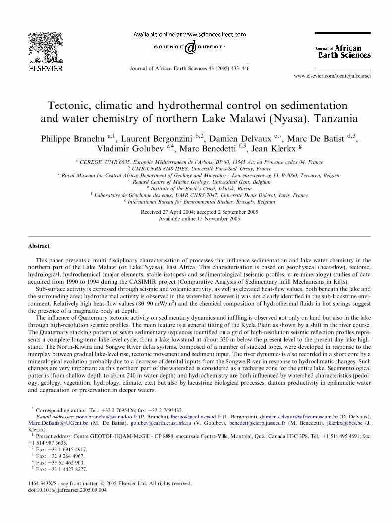
Lake Malawi or Nyasa (Fig. 1) is the second largest lakeof the East African Rift by volume and the fifth largest inthe world. As this water body contains 7% of the world�sfree surface fresh water, its study is extremely importantfor the proper management of freshwater resources. Thecreation and evolution of Lake Malawi, like others in therift, was and still is closely linked with regional geologicalactivity.
The purpose of the present paper is to evaluate the influ-ence of endogenous and exogenous processes on the recentevolution of the Livingstone (or Karonga) Basin (northernbasin of the lake) by combining different geological andlimnological approaches. These included studies of activetectonic movements on land and those expressed by thelake bottom topography, high-resolution reflection seismicprofiling to explore the sedimentary infill and the structuraldeformations affecting it, heat flow measurements, waterchemistry and sediment mineralogy. These differentapproaches were performed within the framework of theCASIMIR project (Comparative Analysis of SedimentaryInfill Mechanisms In Rifts).
Fig. 1. Schematic bathymetric (from Johnson and Davis, 1989) and hydrographand seismic profiles in the Livingstone basin and its catchment. Inset box sho
2. Materials and methods
All data presented here were collected during differentfield expeditions organised between 1990 and 1994 withinthe framework of the CASIMIR project. All lake opera-tions were performed aboard the Nyanja vessel.
The tectonic context of the area was characterised usingpublished geological informations (maps, catalogues andpapers), fieldwork and the interpretation of Landsat TMimages.
Thirteen seismic profiles (Fig. 1) were acquired in Octo-ber 1992 using a Centipede-sparker-seismic source (fre-quency range: 150–1500 Hz, when operated at 300 J) anda single channel streamer (De Batist et al., 1996).
A total of 32 heat-flow measurements were performedin the northern part of the lake during the 1991, 1992and 1993 fieldwork campaigns (Table 1) using a non-autonomous cable thermoprobe which measures thein situ temperature and thermal conductivity of the bottomsediments (Golubev and Klerkx, 1993).
Water and sediment samples for geochemical analysiswere collected in the Livingstone Basin in October 1993(Fig. 1). Three water columns (water depths from 200 to
ic map of Lake Malawi and locations of sediment/water sampling stationsws location of Lake Malawi in Africa.
Table 1Heat flow through the bottom of Lake Malawi (Golubev and Klerkx,1993; Golubev, personal communication)
Station Longitude (East) Latitude (South) Q observed (mW/m2)
P. Branchu et al. / Journal of African Earth Sciences 43 (2005) 433–446 435
245 m) were sampled using 5 L PVC Hydro-Bios� bottles(Fig. 1). Five rivers (Lumbila, Lufirio, Mbaka, Kiwiraand Songwe) and two hydrothermal springs (Mapulo andKasimulo) were sampled on land (Fig. 1). Short cores weresampled in the river mouths (water depth <10 m) and at140 and 225 m water depth using a Bowers & Connelly�
multi-corer (Fig. 1). Electrical conductivity and tempera-ture (�C) were measured in situ at each site using a sealog-ger CTD SBE 25 probe (Sea-Bird Electronics�) for lakewaters and a hand-held pH-conductivity-thermometer forother waters. pH was measured in the laboratory (inFrance) for lake waters and in situ for other samples. Col-lected water samples were filtered (0.01 lm) and treated(sub-sampling and acidification) in the field and then storedin polypropylene bottles in the dark at 4 �C. Cations (Na,K, Ca, Mg) and anions (Cl, SO4) were determined by cap-illary electrophoresis in acidified and unacidified subsam-ples, respectively. Si was determined by ICP-OES(Inductively Coupled Plasma – Optical Emission Spec-trometry) and alkalinity was measured in the laboratoryby potentiometric titration. Chemical analyses were per-formed at the CEREGE (Centre Europeen de Rechercheet d�Enseignement en Geosciences de l�Environnement) inFrance. For isotopic analysis untreated water samples were
stored in amber glass bottles having a double closure. Sam-ples were analysed for oxygen and deuterium isotopicratios (d18O and d2H) at the IDES Laboratory (Orsay,France) following the experimental protocols of Epsteinand Mayeda (1953) and Coleman et al. (1982). Isotopicratios are expressed in & relative to SMOW (StandardMean Ocean Water). Analytical uncertainties are ±0.2and ±2, respectively for d18O and d2H. X-ray diffractionwas performed at the CEREGE on dried and sieved(80 lm) sediment samples and on dried filters used for riverwater processing (see above).
3. Geological, geographical, limnological and
climatological setting
The Malawi Rift is the southernmost rift basin along thewestern branch of the East African Rift System (Figs. 1and 2). It consists of several individual sub-basins whichexhibit a typical asymmetric half-graben architecture (Rey-nolds and Rosendahl, 1984; Ebinger et al., 1984, 1987;Rosendahl, 1987), a common structure in many continentalrifts (Bosworth, 1985). According to classical views, riftingkinematics have remained constant throughout the evolu-tion of the Malawi Rift, with extension occurring eitheralong a W/WSW–E/ENE (Ebinger et al., 1987, 1989; Mor-ley, 1988; Morley et al., 1992) or a WNW/NW–ESE/SE(Tiercelin et al., 1988; Chorowicz, 1989; Wheeler and Kar-son, 1989) direction. An alternative view (Delvaux et al.,1992; Ring et al., 1992) proposes two successive phases ofrift formation, with an early phase of normal faultingoccurring during WSW–ENE extension followed by aphase dominated by strike-slip motion along a WNW/NW–ESE/SE direction. This evolution in tectonic controlof the basin influenced its configuration and overall sedi-mentation pattern. During the first phase, half-grabenswere formed and the general basin morphology of theMalawi Rift was created. In the second phase, NW–SE ori-ented sub-basins were formed due to transtension whiletranspression led to localised uplifts.
The main part of the Malawi Rift is occupied by LakeMalawi (or Lake Nyasa), which has a volume of7790 km3 (Vollmer et al., 2002), a N–S length of 500 kmand a maximum depth of 700 m. The lake is divided intoseven sub-basins corresponding to the half-graben architec-ture described above. The morphology of the Malawi Riftalso influences the local climatic and hydrologic regimes,while the hydrology and hydrodynamics of the lake itselfare, in turn, strongly influenced by the climate (Eccles,1974). The climate is tropical with a ‘‘dry season’’ fromMay to October, characterised by dry cooler conditionsand a fairly constant southerly wind, and a ‘‘wet season’’during the rest of the year, characterised by wetter andwarmer conditions. Lake surface water temperatures fol-low this seasonality with a maximum temperature (28 �C)at the end of February or the beginning of March and aminimum temperature (23 �C) in July and August whenthe water is refreshed by southerly winds. This period
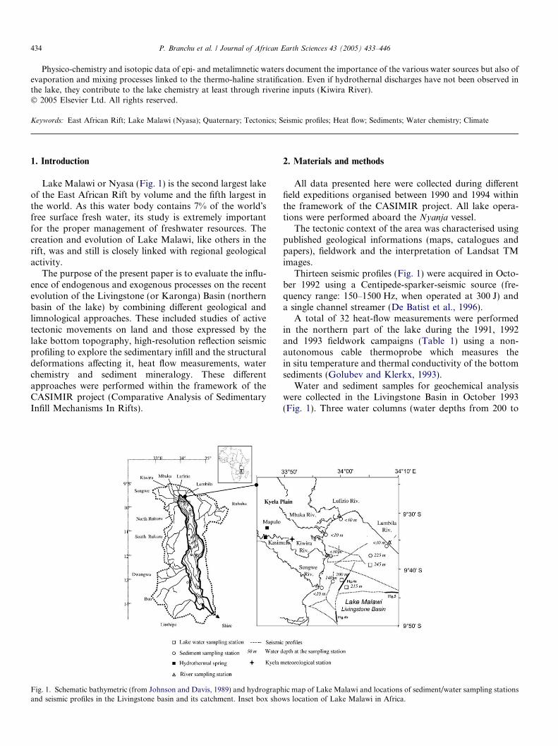
Fig. 2. The Mbeya triple junction and the Rungwe volcanic province between the Rukwa and Malawi rifts and the Usangu–Ruaha depression. TheRungwe volcanics lie at the intersection between the NE-trending basin of Livingstone at the NE extremity of the Malawi rift, the NE-trending Rukwa–Songwe basin at the SE extremity of the Rukwa rift and the NW-trending Usangu rift basin. This triple junction is seismically active, has many active hotsprings and the last volcanic eruption happened about 200 years ago.
436 P. Branchu et al. / Journal of African Earth Sciences 43 (2005) 433–446
corresponds to the occurrence of upwelling and deep cur-rents of cold water in the southern part of the lake (Eccles,1974). The thermocline is located at 80–100 m and developsfrom September to March (Eccles, 1974). Lake Malawi is ameromictic lake and above the thermocline, in the epilim-nion, the water column is well mixed (Eccles, 1974). Below250–300 m, in the hypolimnion, oxygen is not detected inthe lake water (Gonfiantini et al., 1979; Halfman, 1993).There is thus a partial mixing of the first 250 m of the watercolumn (Vollmer et al., 2002).
The Livingstone (or Karonga) Basin, the northernmostsub-basin, is partly occupied by the Kyela Plain and showsa particularly well-expressed down-to-the-east half-grabenasymmetry. The submerged portion of the basin is limitedat its eastern side by the 2000 m high scarp of the Living-stone Border Fault (Fig. 2). It is deeper in this part (about550 m water depth) and shoals to the southwest via a seriesof tilted fault blocks (Scholz et al., 1989; Specht and Rosen-dahl, 1989).
Meteorological stations at Kyela (Fig. 1), Musekera(9�20 0 S – 33�41 0 E) and Tukuyu (9�15 0 S – 33�38 0 E), inthe northern part of the lake watershed, report amean annual rainfall of 2500 mm year�1, which is abouttwice that reported for the entire lake watershed(1350 mm year�1) as well as from stations farthernorth (Mbeya: 1000 mm year�1) and south (Karonga:1200 mm year�1). The up to 2700 m high mountains sur-rounding the northern shores of Lake Malawi are respon-sible for the high precipitation rates in this area.
River discharge in the Livingstone Basin is much higherthan in the southern part of the lake (Bergonzini, 1998).Lake watershed (126500 km2, including the lake) is mainlylocated on its western coast (Fig. 1), which includes thewatersheds of the Songwe, North and South Rukuru,Dwanga, Bua and Linthipe Rivers (Fig. 1). The eastern
part of the basin is mainly drained by the Ruhuhu River(Fig. 1). In the northern part of the basin the Songwe, Kiw-ira, Mbaka, Lufirio and Lumbila Rivers (Fig. 1) drain thePoroto-Rungwe and Livingstone mountains; owing toheavy precipitation in this area these rivers have a veryhigh annual discharge rate (Bergonzini, 1998).
4. Land and sub-lacustrine evidence of tectonic activity inthe Livingstone Basin
The Kyela Plain is located at the northern extremity ofLake Malawi (Figs. 1 and 2). This part of the Malawi Riftbasin is almost perfectly aligned with the south-easternextremity of the Rukwa Rift valley, with which it forms adominant NW–SE rift trend, and is structurally connectedwith the transversal NE–SW trending Usangu-Ruahadepression (Fig. 2). This configuration defines a rift–rift–rift triple junction, on the centre of which is developedthe Rungwe volcanic province (Harkin, 1960; Ebingeret al., 1989). The area is known to be seismically active(Camelbeeck and Iranga, 1996), with volcanic eruptionsoccurring until early historical times and hot spring activitystill found today.
Cenozoic rifting is believed to start at about 8 Ma ago(Late Miocene) in the Mbeya triple junction area via asym-metric normal faulting, block tilting and basin subsidence(Ebinger et al., 1989, 1993). Sedimentation occurred con-temporaneously with the first two volcanic pulses of theRungwe volcanic province, between 8.6 Ma and the Plio-Quaternary transition. Paleostress analysis of minor faultsin relation to well-dated sediments and volcanics showsthat the structural evolution of the rift basins and relatedsedimentation and volcanism occurred in a tectonic systemdominated by normal faulting under a semi-radial exten-sional stress field (Delvaux et al., 1992; Ring et al., 1992).
P. Branchu et al. / Journal of African Earth Sciences 43 (2005) 433–446 437
The Late Pliocene to Early Pleistocene, a period of tec-tonic quiescence, is marked by a low lake level and intenseweathering and erosion (Crossley, 1982; Ebinger et al.,1993). Neither sediments nor volcanics were deposited dur-ing this period, which corresponds to the development ofan extensive morphological surface covered by lateritic soil(African two geomorphological surface of King, 1963).This exposure caused an erosional and structural unconfor-mity, over which Quaternary lake beds were deposited(Crossley, 1982; Ebinger et al., 1993).
A new kinematic regime started during the Middle Pleis-tocene together with a new pulse of tectonic activity andrenewed sedimentation (Delvaux et al., 1992). This secondregime is still active today and corresponds to the Neotec-tonic period (Delvaux and Hanon, 1993). It is characterisedby horizontal principal compression and extension axes,typical for a strike-slip regime, with a dominant N–S hor-izontal compression and an E–W principal extension. Thisregime induced dextral strike-slip reactivation of NW-trending rift faults. The volcanic activity continued duringthe Quaternary, with a series of eruptions in the Rungwearea occurring during the Holocene (Ebinger et al., 1989;Williams et al., 1993).
Two kinds of Quaternary vertical movements are evi-dent in the Rukwa-North Malawi area: (i) block tilting inboth the Kyela and Rukwa Plains (Delvaux and Hanon,1993; Delvaux, 1995) and (ii) a regional domal uplift cen-tred on the Rungwe–Ngozi volcanic area. These combinedmovements induced a SE and NE tilting of the Kyela Plainand caused an important mass transfer through erosion
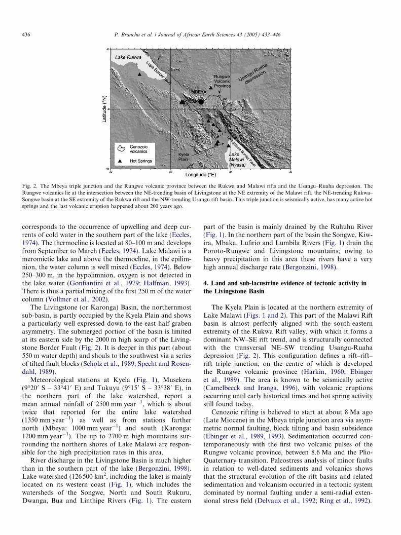
Fig. 3. Geomorphological and sedimentological evidences of the general tiltingmajor Livingstone rift border fault (from Delvaux and Hanon, 1993). Migratioseismic data of De Vos, 1994). Modern mineralogical assemblages of river/lak
and sedimentation towards the Kyela Plain, at the footof the Livingstone scarp.
Block faulting and active tilting in the Kyela Plain isshown from the examination of LANDSAT-TM imageryand fieldwork (Delvaux and Hanon, 1993). The NW-trend-ing Mbaka fault traverses the central part of the plain. Anabandoned section of the Mbaka River is located exactlyon a well-defined lineament that could represent the trackof the fault on the plain. The prolongation of this linea-ment into the lake is marked by an alignment of sub-lacus-trine gas vent observed visually (at 4 m deep) near themouth of the Kiwira River and by a small active fault scarpdetected on seismic profiles (Versteeg et al., 1993; De Vos,1994).
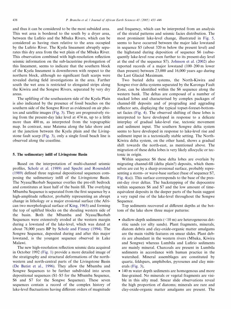
A general tilting of the Kyela Plain is shown by a sys-tematic north-eastward shift of the rivers, which flow intoLake Malawi. The best example is the migration of theactive delta system of the Kiwira River (Fig. 3). On land,the southern branch of the Kiwira River delta system isinactive, but it is still clearly expressed. In the lake itselfhigh-resolution seismic profiles demonstrate the successivenorth-eastward migration of three buried delta lobes (Figs.3 and 4(a)) high in the sedimentary section (De Batist et al.,1996).
The soil moisture content, estimated from the vegetationindex on LANDSAT-TM false colour composition givesan indication about the relative elevation of the plain. Atthe northern tip of Lake Malawi, a large wet area fringesthe coastline and extends along the Lufirio River and itstributaries. It is also the lowest part of the Kyela Plain,
of the Kyela plain based on lateral shift of the river network towards then of underwater delta lobes (based on the interpretation of high resolutione sediments and river suspended matter (SM).
438 P. Branchu et al. / Journal of African Earth Sciences 43 (2005) 433–446
and thus it can be considered to be the most subsided area.This wet area is bordered to the south by a dryer area,between the Lufirio and the Mbaka Rivers, which can beconsidered as having risen relative to the area occupiedby the Lufirio River. The Kyela lineament abruptly sepa-rates this dry area from the wet plain of the Mbaka River.This observation combined with high-resolution reflectionseismic information on the sub-lacustrine prolongation ofthis lineament, seems to indicate that the southern blockof the Kyela lineament is downthrown with respect to thenorthern block, although no significant fault scarps wererevealed during field investigations in the area. Farthersouth the wet area is restricted to elongated strips alongthe Kiwira and the Songwe Rivers, separated by very dryareas.
The uplifting of the southeastern side of the Kyela Plainis also indicated by the presence of fossil beaches on thesouthern side of the Songwe River as evidenced on air pho-tos and satellite images (Fig. 3). They are progressively ris-ing from the present-day lake level at 474 m, up to a littlemore than 480 m, as interpreted from the topographicmap. In contrast, near Matema along the lake shore andat the junction between the Kyela plain and the Living-stone fault scarp (Fig. 3), only a single fossil beach line isobserved along the coastline.
5. The sedimentary infill of Livingstone Basin
Based on the interpretation of multi-channel seismicprofiles, Scholz et al. (1989) and Specht and Rosendahl(1989) defined three regional depositional sequences com-posing the sedimentary infill of the Livingstone Basin.The Nyasa/Baobab Sequence overlies the pre-rift bedrockand constitutes at least half of the basin fill. The overlyingMbamba Sequence is separated from the first sequence by ahigh-amplitude reflector, probably representing an abruptchange in lithology or a major erosional surface (the Afri-can two morphological surface of King, 1963) and formingthe top of uplifted blocks on the shoaling western side ofthe basin. Both the Mbamba and Nyasa/BaobabSequences were extensively eroded at the western marginduring a lowstand of the lake-level, which was dated atabout 78,000 years BP by Scholz and Finney (1994). TheSongwe Sequence, deposited during and after this majorlowstand, is the youngest sequence observed in LakeMalawi.
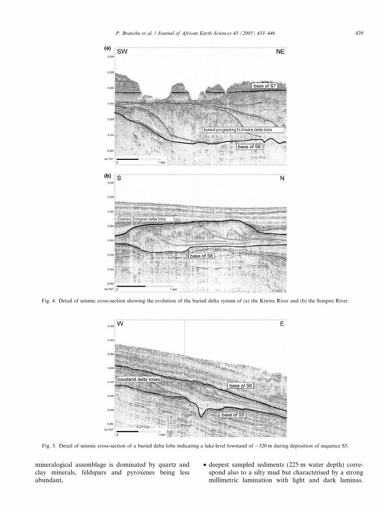
The new high-resolution reflection seismic data acquiredin October 1992 (Fig. 1) provide a more detailed image ofthe stratigraphy and structural deformations of the north-western and north-central parts of the Livingstone Basin(De Batist et al., 1996). They allow the Mbamba andSongwe Sequences to be further subdivided into sevendepositional sequences (S1–S5 for the Mbamba Sequence,S6 and S7 for the Songwe Sequence). These sevensequences contain a record of the complex history oflake-level fluctuations having different orders of magnitude
and frequency, which can be interpreted from an analysisof the stratal patterns and seismic facies distribution. Themost prominent lake-level change, illustrated in Fig. 5,seems to have occurred between the major lake lowstandin sequence S5 (about 320 m below the present level) andthe highstand during deposition of sequence S6 (subse-quently lake-level rose even further to its present-day levelat the end of the sequence S7). Johnson et al. (2002) alsoreported records of a major lowstand (100–200 m lowerthan present) between 23,000 and 16,000 years ago duringthe Last Glacial Maximum.
Two buried delta systems, the North-Kiwira andSongwe river delta systems separated by the Karonga FaultZone, can be identified within the S6 sequence along thewestern bank. The deltas are composed of a number ofstacked lobes and characterised by complex packages ofchannel-fill deposits and of prograding and aggradingreflector sets, displaying the typical topset-foreset-bottom-set facies (Fig. 4). The observed shifting of these lobes isinterpreted to have developed in response to a delicateinterplay of gradual lake-level rise, tectonic movementand sediment input. The southern Songwe delta systemseems to have developed in response to lake-level rise andsediment input in a tectonically stable setting. The North-Kiwira delta system, on the other hand, shows a gradualshift towards the north-east, as mentioned above. Themigration of these delta lobes is very likely allocyclic or tec-tonic in origin.
Within sequence S6 these delta lobes are overlain bymigrating channel-fill (delta plain?) deposits, which them-selves are cut by a sharp erosional surface, probably repre-senting a storm- or wave-base surface (base of sequence S7,Fig. 4(a)). This surface corresponds to the base of the pres-ent-day river deltas. The backstepping of the depocentrewithin sequences S6 and S7 and the low amount of time-equivalent deposits in the deeper parts of the basin suggesta very rapid rise of the lake-level throughout the SongweSequence.
Top sediments recovered at different depths at the bot-tom of the lake show three major patterns:
• shallow-depth sediments (<10 m) are heterogeneous det-ritic sands (or silty sands). Plant fragments, minerals,diatom debris and clay-oxide-organic matter amalgamsare the main visible features on smear slides. Plant deb-ris are abundant in the western rivers (Mbaka, Kiwiraand Songwe) whereas Lumbila and Lufirio sedimentsare mainly mineral. Charcoals are present in Lumbilasediments in accordance with human practice in thewatershed. Mineral assemblages are constituted byquartz, feldspars, amphiboles, pyroxenes and clay min-erals (Fig. 3),
• 140 m water depth sediments are homogenous and morefine-grained. No minerals or vegetal fragments are visi-ble in this silty mud. Smear slide observations revealthe high proportion of diatoms; minerals are rare andclay-oxide-organic matter amalgams are present. The
Fig. 4. Detail of seismic cross-section showing the evolution of the buried delta system of (a) the Kiwira River and (b) the Songwe River.
Fig. 5. Detail of seismic cross-section of a buried delta lobe indicating a lake-level lowstand of �320 m during deposition of sequence S5.
P. Branchu et al. / Journal of African Earth Sciences 43 (2005) 433–446 439
mineralogical assemblage is dominated by quartz andclay minerals, feldspars and pyroxenes being lessabundant,
• deepest sampled sediments (225 m water depth) corre-spond also to a silty mud but characterised by a strongmillimetric lamination with light and dark laminas.
440 P. Branchu et al. / Journal of African Earth Sciences 43 (2005) 433–446
Smear slides show the abundance of diatom and clayamalgams. The mineralogical assemblage is similar tothe former one.
These features fit well shallow to deep sedimentologicalpatterns defined previously (Johnson and Davis, 1989;Owen and Crossley, 1989; Johnson and Ng�ang�a, 1990;Pilskaln and Johnson, 1991). The lamination in the deepestcore is a direct evidence of the seasonal signal. Diatoma-ceous (light) horizons are deposited during the dry windyseason while the more terrigenous (mineral and organic)ones are deposited during the rainy season (Pilskaln andJohnson, 1991).
River sediment mineralogy is influenced by the geologyof the watershed, the weathering processes and the hydro-dynamism. White micas come mainly from the Kiwira andSongwe catchments (Precambrian micashists), plagioclasesare present in all watersheds but the highest proportionsoccur in Lumbila sediments (Precambrian anorthosites),K-feldspars are mainly issued from Mbaka and Lufiriowatersheds (trachytes and trachy-andesites). Black micasof the Mbaka River are probably issued from the trachytesand/or the phonolithes. X-ray diffraction performed onriver suspended matter only exhibits clay mineral (Fig. 3).The kaolinite and illite minerals are present in the Songwe,Kiwira, Lumbila and Mbaka Rivers. Lufirio and MbakaRiver suspended matters are characterised by occurrenceof the vermiculite mineral. Kaolinite is a common mineralof weathering profiles under wet climate (Pedro, 1968). Theillite mineral is mainly generated on granitic and metamor-phic rocks that are present in Songwe, Kiwira and Lumbilacatchments. Its occurrence in Mbaka River is probablyassociated to the presence of lacustrine sediments in thecatchment. The vermiculite mineral characterises a lowintensity weathering process that can occur in altitude onsteep and instable slopes, conditions that are present inMbaka and Lumbila watersheds where precipitation areimportant and where geology is dominated by the volcanicrocks.
Lake sediment mineralogy is then influenced by thesedifferent sources (geological + weathering) and deposi-tional processes (vicinity of the river mouths anddynamic processes). Due to depositional dynamics, theproportion of clay minerals increases with the distanceto the source.
The change in mineralogical assemblage with depth inthe 140 m water depth core (Fig. 3) suggests a temporalchange in mineral sources. Due to the core location, themodern sediments are influenced by the Songwe and Kiw-ira material inputs. The relative increase of K-feldspar andmainly plagioclase proportions downward could be inter-preted as a stop or a decrease of the sedimentary inputsby the Songwe River at this point. This evolution, notyet dated, could be linked to relatively drier climatic condi-tions with little impact on the farther north watershedslocated in the rainy area of the Rungwe (see above). Sucha decline in regional precipitation, associated with a drop
of the lake-level was evidenced in Lake Malawi at theend of the Little Ice Age (Owen et al., 1990; Johnsonet al., 2001; Nicholson and Yin, 2001). Thus the overallnorthward shift of the rivers of the Kyela Plain duringthe Quaternary (but not yet dated) is accompanied byhydrodynamic modifications of some rivers as the resultof climatic changes.
6. Heat flow in Livingstone Basin
Von Herzen and Vacquier (1967) performed 20 heat-flow measurements in the bottom sediments of LakeMalawi, obtaining values from 8 to 120 mW/m2 with anaverage of 45 mW/m2. The high variability of the heat flowwas assumed by these authors to be related to the effects oflocal high sedimentation rates and past changes in lakewater temperature. Ebinger et al. (1987) calculated correc-tions for the sedimentation effect and defined the averageheat flow through the bottom of Lake Malawi at75.3 ± 35 mW/m2, which is 1.5 times higher than the meanvalue for the African continent (49.8 mW/m2, Sclater et al.,1980).
New heat-flow measurements were performed duringthe present study in the northern part of the lake between1991 and 1993 (Golubev and Klerkx, 1993; Golubev, per-sonal communication). The investigated area occupies 1/20 of the entire lake, but even in this small area themeasured raw heat-flow values (32 measurements, Table1) vary from �7 to 108 mW/m2 (average: 47 mW/m2).The negative value obviously is related to a landslideeffect and was obtained near the north-eastern shorealong the Livingstone border fault. The highest valueswere obtained in the foothill of the western underwaterslope.
The measured heat-flow values were corrected using thenomograms of Hutchinson (1985), considering the thick-ness of the sediment layer given by Specht and Rosendahl(1989). After corrections the variations of the heat-flowvalues appear to be smaller. The values do not exceed30 mW/m2 near the north-eastern border, then increaseto 50–60 mW/m2 along the lake axis and reach values ofup to 80–90 mW/m2 in the western part of the lake.
Several possible mechanisms may explain the three-foldincrease of the heat flow along a NE–SW profile acrossLivingstone Basin:
• the increase reflects the actual trend of the deep heatflow through the basement as caused by a local heat-flow source. For example, the presence of a ‘‘fresh’’mantle diapir was suggested by Ebinger et al. (1987)on the basis of multi-channel reflection seismic profiles;
• the increase may be related to seasonal and longer-termvariations of bottom water temperatures. In this regardit should be noted that high values were obtained in thesites where the water depth was less than 200 m, wheresuch effects can be important;
P. Branchu et al. / Journal of African Earth Sciences 43 (2005) 433–446 441
• local heat flow increases may be related to hydrothermaldischarge on the lake floor. Although the presence ofhydrothermal activity could not be ascertained, gas ema-nations at the lake floor have been observed locally (seepart 4);
• the blanketing effect of sediments which has a greaterthickness towards the Livingstone border fault.
7. Geochemical characteristics of Livingstone Basin
7.1. Hydrothermal activity
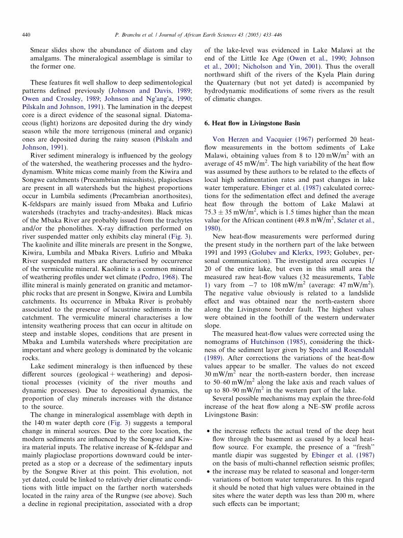
Two hydrothermal springs were observed and sampledon land during the present work (Delvaux and Hanon,1993; Branchu, 2001) extending previous characterisationsof this area (part of the volcanic Rungwe Massif located inLake Malawi catchment) by other authors (James, 1959;Kirkpatrick, 1969; Pisarskii et al., 1998; Hochstein et al.,2000). The Mapulo spring is located in a swampy area cov-ered by calcareous crusts. In this hydrothermal field bothhot and cold (not sampled) springs occur with gaz emis-sion. The Kasimulo spring is located between the Songweand Kiwira Rivers and is restricted to one spring withlower discharge rate than in Mapulo and with no visiblegaz emission. The chemical and isotopic composition andthe temperature of the samples are presented in Table 2.Both springs have neutral pH. The majority of the NorthMalawi hydrothermal springs are characterised by temper-atures ranging from 50 to 80 �C (Table 3) but some coldvents are present. Fluids have high Na (>34 mmol/l), andHCO3 (>1400 mmol/l) contents (Table 3). In a triangular
Table 2Physical–chemical characterisation of the lake water column, rivers and hydro
dD (& vs.SMOW)
d18O (& vs.SMOW)
T (�C) pH K
(
Lake
Epilimnion 0–75 m (13b) +11 +2.0 24.9 8.47d 0Metalimnion 100–240 m (11c) +12 +2.0 23.4 8.04d 0
n.d. = not detected.– = not calculated.a Relative density: (computed density)/(computed density of lake surface w
Poisson, 1981). Lake and river salinities are computed from their chemical cob (13) is the number of samples used to calculate metalimnetic average valuec (11) is the number of samples used to calculate epilimnetic average valuesd Measured at the laboratory in France.e Values calculated (as HCO3) from the difference of meq cations minus me
Cl–SO4–HCO3 diagram (Giggenbach, 1991) all the springsplot in the carbonate corner. Based on their chemical com-position two groups are defined: the northern (upperSongwe valley) and the southern groups with higher Na,sulfate and carbonate and a lower K content. In eachgroup Na/K mass ratio is constant suggesting an homoge-nous fluid at depth. Springs plotted in a triangular Na–K–Mg diagram (Giggenbach, 1991) are immature (nochemical equilibrium) and partially equilibrated for thesouthern and the northern groups, respectively. These posi-tions do not allow to compute a reservoir temperature bycationic geothermometers. However temperatures of 220and 250 �C, for the southern and the northern groups,respectively, are estimated from the spring alignment foreach group. The isotopic composition of the two sampledsprings are located on the regional meteoric line (Bergonz-ini, 1999) and below the mean composition (dD = �21&;d18O = �4.1&) of the three AIEA/WMO stations enclos-ing the region (Rozanski et al., 1996; Bergonzini et al.,2001). Furthermore their compositions are similar to thoseof the Kiwira River. The same origin is attributed to thetwo groups of spring and in the Songwe group Ca, Mg,Li, Rb and Sr come from a magma chamber at depthlinked to the Rungwe Massif (Pisarskii et al., 1998).From their isotopic and chemical compositions thesesprings can be associated with high-temperature systems,probably of volcanic origin, but highly diluted by meteoricwater. This hydrothermal context is then pretty similarto the nearby Lake Tanganyika where Na–HCO3 richsub-aquatic manifestations are associated to the presenceof a degassing magmatic body at depth (Pflumio et al.,1994).
thermal springs sampled in the northern part of Lake Malawi (Tanzania)
Ca Na Mg Cl SO4 Si Alkalinity(meq/l)
Relativedensityammol/l)
.16 0.47 0.89 0.30 0.12 0.01 0.017 2.37 1
.17 0.48 0.9 0.30 0.11 0.004 0.091 2.42 –
.15 0.32 0.5 0.21 <0.01 0.07 0.36 1.27 0.998
.35 0.18 2.66 0.20 1.04 n.d. 4.25 2.29 0.999
.18 0.24 0.87 0.18 0.02 n.d. 0.54 1.75 0.999
.11 0.49 0.68 0.23 n.d. n.d. 0.30 2.12 0.999
.06 0.22 0.21 0.1 n.d. n.d. 0.30 0.82 1.001
.75 0.95 53.21 0.91 7.12 3.12 1.78 50e –
.89 1.13 58.23 0.93 6.27 3.89 1.52 45e –
aters). Density is computed from salinity and temperature (Millero andmposition. Density linked to suspended matter is not considered.s except for isotopes (7) and alkalinity (3).except for isotopes (5) and alkalinity (4).
q anions.
Table 3Chemical composition of hydrothermal springs in the part of the Rungwe volcanic massif located in Lake Malawi catchment
n.d.: not determined.Ref.: 1, This work; 2, Makundi and Kifua (1985) in Hochstein et al. (2000); 3, Harkin (1960) in Hochstein et al. (2000); 4, Pisarskii et al. (1998); 5, James(1959).a Doubtful composition: cationic excess.
442 P. Branchu et al. / Journal of African Earth Sciences 43 (2005) 433–446
7.2. Water chemistry and isotopic composition
The lake water chemistry is controlled by the nature of thedifferent inputs (hydrothermal, rivers, atmospheric), by lakesurface evaporation, by biogeochemical processes in thewater column (productivity/degradation, precipitation/dis-solution) and by mixing/exchange processes between the dif-ferent lake compartments (epi-, meta- and hypolimnion).
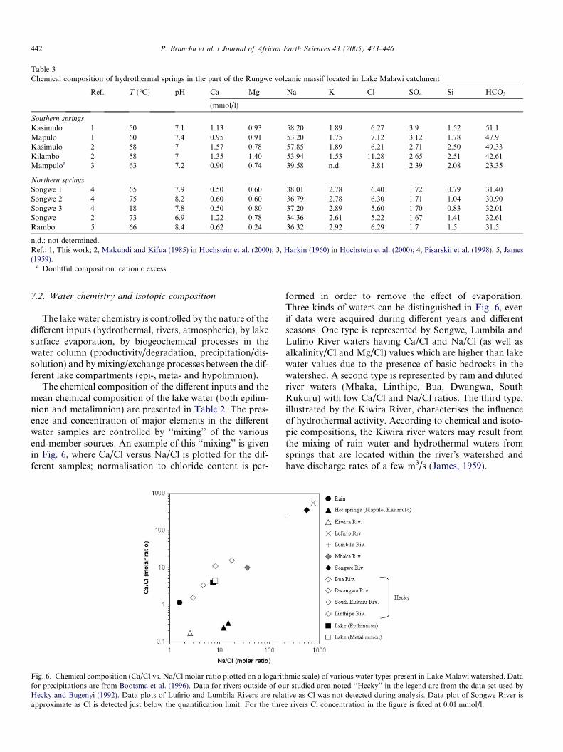
The chemical composition of the different inputs and themean chemical composition of the lake water (both epilim-nion and metalimnion) are presented in Table 2. The pres-ence and concentration of major elements in the differentwater samples are controlled by ‘‘mixing’’ of the variousend-member sources. An example of this ‘‘mixing’’ is givenin Fig. 6, where Ca/Cl versus Na/Cl is plotted for the dif-ferent samples; normalisation to chloride content is per-
Fig. 6. Chemical composition (Ca/Cl vs. Na/Cl molar ratio plotted on a logaritfor precipitations are from Bootsma et al. (1996). Data for rivers outside of ouHecky and Bugenyi (1992). Data plots of Lufirio and Lumbila Rivers are relaapproximate as Cl is detected just below the quantification limit. For the thre
formed in order to remove the effect of evaporation.Three kinds of waters can be distinguished in Fig. 6, evenif data were acquired during different years and differentseasons. One type is represented by Songwe, Lumbila andLufirio River waters having Ca/Cl and Na/Cl (as well asalkalinity/Cl and Mg/Cl) values which are higher than lakewater values due to the presence of basic bedrocks in thewatershed. A second type is represented by rain and dilutedriver waters (Mbaka, Linthipe, Bua, Dwangwa, SouthRukuru) with low Ca/Cl and Na/Cl ratios. The third type,illustrated by the Kiwira River, characterises the influenceof hydrothermal activity. According to chemical and isoto-pic compositions, the Kiwira river waters may result fromthe mixing of rain water and hydrothermal waters fromsprings that are located within the river�s watershed andhave discharge rates of a few m3/s (James, 1959).
hmic scale) of various water types present in Lake Malawi watershed. Datar studied area noted ‘‘Hecky’’ in the legend are from the data set used bytive as Cl was not detected during analysis. Data plot of Songwe River ise rivers Cl concentration in the figure is fixed at 0.01 mmol/l.
P. Branchu et al. / Journal of African Earth Sciences 43 (2005) 433–446 443
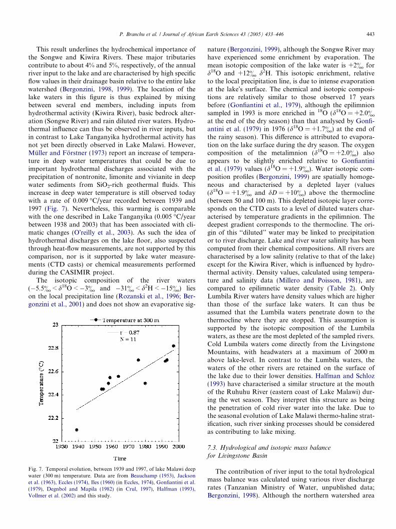
This result underlines the hydrochemical importance ofthe Songwe and Kiwira Rivers. These major tributariescontribute to about 4% and 5%, respectively, of the annualriver input to the lake and are characterised by high specificflow values in their drainage basin relative to the entire lakewatershed (Bergonzini, 1998, 1999). The location of thelake waters in this figure is thus explained by mixingbetween several end members, including inputs fromhydrothermal activity (Kiwira River), basic bedrock alter-ation (Songwe River) and rain diluted river waters. Hydro-thermal influence can thus be observed in river inputs, butin contrast to Lake Tanganyika hydrothermal activity hasnot yet been directly observed in Lake Malawi. However,Muller and Forstner (1973) report an increase of tempera-ture in deep water temperatures that could be due toimportant hydrothermal discharges associated with theprecipitation of nontronite, limonite and vivianite in deepwater sediments from SiO2-rich geothermal fluids. Thisincrease in deep water temperature is still observed todaywith a rate of 0.009 �C/year recorded between 1939 and1997 (Fig. 7). Nevertheless, this warming is comparablewith the one described in Lake Tanganyika (0.005 �C/yearbetween 1938 and 2003) that has been associated with cli-matic changes (O�reilly et al., 2003). As such the idea ofhydrothermal discharges on the lake floor, also suspectedthrough heat-flow measurements, are not supported by thiscomparison, nor is it supported by lake water measure-ments (CTD casts) or chemical measurements performedduring the CASIMIR project.
The isotopic composition of the river waters(�5.5& < d18O < �3& and �31& < d2H < �15&) lieson the local precipitation line (Rozanski et al., 1996; Ber-gonzini et al., 2001) and does not show an evaporative sig-
Fig. 7. Temporal evolution, between 1939 and 1997, of lake Malawi deepwater (300 m) temperature. Data are from Beauchamp (1953), Jacksonet al. (1963), Eccles (1974), Iles (1960) (in Eccles, 1974), Gonfiantini et al.(1979), Degnbol and Mapila (1982) (in Crul, 1997), Halfman (1993),Vollmer et al. (2002) and this study.
nature (Bergonzini, 1999), although the Songwe River mayhave experienced some enrichment by evaporation. Themean isotopic composition of the lake water is +2& ford18O and +12& d2H. This isotopic enrichment, relativeto the local precipitation line, is due to intense evaporationat the lake�s surface. The chemical and isotopic composi-tions are relatively similar to those observed 17 yearsbefore (Gonfiantini et al., 1979), although the epilimnionsampled in 1993 is more enriched in 18O (d18O = +2.0&at the end of the dry season) than that analysed by Gonfi-antini et al. (1979) in 1976 (d18O = +1.7&) at the end ofthe rainy season). This difference is attributed to evapora-tion on the lake surface during the dry season. The oxygencomposition of the metalimnion (d18O = +2.0&) alsoappears to be slightly enriched relative to Gonfiantiniet al. (1979) values (d18O = +1.9&). Water isotopic com-position profiles (Bergonzini, 1999) are spatially homoge-neous and characterised by a depleted layer (values(d18O = +1.9& and dD = +10&) above the thermocline(between 50 and 100 m). This depleted isotopic layer corre-sponds on the CTD casts to a level of diluted waters char-acterised by temperature gradients in the epilimnion. Thedeepest gradient corresponds to the thermocline. The ori-gin of this ‘‘diluted’’ water may be linked to precipitationor to river discharge. Lake and river water salinity has beencomputed from their chemical compositions. All rivers arecharacterised by a low salinity (relative to that of the lake)except for the Kiwira River, which is influenced by hydro-thermal activity. Density values, calculated using tempera-ture and salinity data (Millero and Poisson, 1981), arecompared to epilimnetic water density (Table 2). OnlyLumbila River waters have density values which are higherthan those of the surface lake waters. It can thus beassumed that the Lumbila waters penetrate down to thethermocline where they are stopped. This assumption issupported by the isotopic composition of the Lumbilawaters, as these are the most depleted of the sampled rivers.Cold Lumbila waters come directly from the LivingstoneMountains, with headwaters at a maximum of 2000 mabove lake-level. In contrast to the Lumbila waters, thewaters of the other rivers are retained on the surface ofthe lake due to their lower densities. Halfman and Schloz(1993) have characterised a similar structure at the mouthof the Ruhuhu River (eastern coast of Lake Malawi) dur-ing the wet season. They interpret this structure as beingthe penetration of cold river water into the lake. Due tothe seasonal evolution of Lake Malawi thermo-haline strat-ification, such river sinking processes should be consideredas contributing to lake mixing.
7.3. Hydrological and isotopic mass balance
for Livingstone Basin
The contribution of river input to the total hydrologicalmass balance was calculated using various river dischargerates (Tanzanian Ministry of Water, unpublished data;Bergonzini, 1998). Although the northern watershed area
444 P. Branchu et al. / Journal of African Earth Sciences 43 (2005) 433–446
represents only 8% of the total lake watershed, the riverinputs from this area account for almost 8 km3/year andrepresent about 20% of total runoff into the lake.
The annual hydrological budget for the northern part ofthe Livingstone basin shows that river water input repre-sents 82% of the total input (precipitation + runoff). Thiszone covering 690 km2, represents about 9% of the lake�ssurface and has a mean depth of 203 m. This area has noreal hydrological existence but has been used in order tocompute the role of the corresponding watershed. Thisannual budget, calculated under the assumption of steadystate conditions (precipitation + runoff = evapora-tion + ‘‘outflow’’), highlights a net north-to-south waterflux and indicates that this region is one of the main waterrecharge areas for the entire lake. A water residence time of18 years has been calculated for this zone. Moreover, acrude isotopic budget for the northern part of the lakeshows that the composition of the northern area resultsfrom a north–south water exchange of several km3/yearand that this area is an important zone of mixing withregards to hydrodynamics of the entire lake.
8. Summary
A multi-disciplinary characterisation of the northernpart of Lake Malawi has been performed on both landand in the lake during several fieldtrips related to theCASIMIR project. This study illustrates the geologicaland hydro-sedimentological dynamics of the system.
Relatively high heat-flow measurements (80–90 mW/m2)in the area can be interpreted as being due to the presenceof a ‘‘fresh’’ mantle diapir, long-term variations of bottomwater temperature, or sub-lacustrine hydrothermal dis-charges. Chemical characterisation of hydrothermalsprings on land can also be explained by the presence ofa degassing magmatic body in depth. Physical–chemicalcharacteristics of the lake water, including deep-water heat-ing, which is probably linked to climate change, do notsupport the assumption of large sub-lacustrine hydrother-mal discharges. Major element and isotope hydrochemistryof the lake and river waters is explained by the control ofrainwater and watershed geology, by on-land hydrother-mal activity, by evaporation from the lake and by biogeo-chemical processes in the water column.
The seismic profiles show the presence of seven deposi-tional sequences making up the upper part of the basin fillof Livingstone Basin. These seven sequences define a com-plete long-term lake-level cycle, from a lake lowstand atabout 320 m below the present level to the present-day lakehighstand. Higher-frequency lake-level oscillations con-trolled the succession of sedimentary facies within each ofthe sequences. Two buried delta systems, the North-Kiwiraand Songwe River delta systems are composed of a numberof stacked lobes. The Songwe delta system developed inresponse to the interplay between gradual lake-level rise,tectonic movement and sediment input, while the north-eastward migration of the North-Kiwira system is likely
to be allocyclic or tectonic in origin. These dynamics areillustrated, on a shorter time-scale, by mineralogicalchanges observed down a core, suggesting a recent changein mineral sources linked to a decrease of detritic inputs bythe western Songwe.
This multi-disciplinary approach has led to a precisecharacterisation of a poorly known area of the LakeMalawi watershed. This area is a main recharge zone forthe entire lake, is characterised by an unique geological set-ting (active volcanism, hydrothermal activity) and isaffected by tectonic block tilting.
Acknowledgements
The authors are very grateful to Stan Beaubien for Eng-lish improvement of the manuscript. The French authorswould like to acknowledge the contribution of GDR PRO-MESSE (Processus Physiques et Chimiques d�Enregistre-ment et de Perturbation des Messages Sedimentaires,coordinator Prof. B. Hamelin) and the CNRS FU No. 17(Centre Europeen de Recherche et d�enseignement en Geo-sciences de l�Environnement).
References
Beauchamp, R.S., 1953. Hydrological data from Lake Nyasa. J. Ecol. 41,226–239.
Bergonzini, L., 1998. Bilans hydriques de lacs (Kivu, Tanganyika, Rukwa& Nyassa) du rift est-africain. Mus. Roy. Afr. Centr., Tervuren, Ann.Sc. Geol., vol. 103, 183 p.
Bergonzini, L., 1999. Elements d�hydrologie isotopique au nord dulac Malawi (Afrique de l�Est), premiers resultats et enseignements.Mus. Roy. Afr. Centr., Tervuren, Rapp. Ann., 1997–1998, pp. 167–176.
Bergonzini, L., Gibert, E., Winckel, A., Merdaci, O., 2001. Bilanshydrologiques et isotopiques (18O et 2H) du lac Massoko, Tanzanie.Quantification des echanges lac-eaux souterraines. CR Acad. Sci. 333,617–623.
Bootsma, H.A., Bootsma, M.J., Hecky, R.E., 1996. The chemicalcomposition of precipitation and its significance to the nutrient budgetof Lake Malawi. In: Johnson, T.C., Odada, E.O. (Eds.), TheLimnology, Climatology and Palaeoclimatology of the East AfricanLakes. Gordon and Breach, Amsterdam, pp. 241–250.
Bosworth, W., 1985. Geometry of propagating continental rifts. Nature316, 625–627.
Branchu, Ph., 2001. Cycle des elements majeurs et traces dans les grandslacs de rift tropicaux (Lacs Tanganyika et Malawi). Processus etenregistrements biogeochimiques. Mus. Roy. Afr. Centr., Tervuren,Ann. Sc. Geol., vol. 106, 374 p.
Camelbeeck, T., Iranga, M.D., 1996. Deep crustal earthquakes andgeometry of active faults along the Rukwa trough, East Africa.Geophys. J. Int. 124, 612–630.
Chorowicz, J., 1989. Transfer and transform fault zones in continentalrifts: Example in the Afro-Arabian Rift System. Implications of crustbreaking. J. Afr. Earth Sci. 8, 203–214.
Coleman, M., Stephen, T., Durham, J., Rousse, J., Moore, G., 1982.Reduction of water with zinc for hydrogen analysis. Anal. Chem. 54,993–995.
Crossley, R., 1982. Late Cenozoic stratigraphy of the Karonga area in theMalawi rift. Palaeoecol. Afr. 15, 139–144.
Crul, R.C.M., 1997. Limnology and Hydrology of Lakes Tanganyikaand Malawi. Studies and reports in hydrology No. 54, UNESCO,111 p.
P. Branchu et al. / Journal of African Earth Sciences 43 (2005) 433–446 445
De Batist, M., Van Rensbergen, P., Back, P., Klerkx, J., 1996. Structuralframework, sequence stratigraphy and lake level variations in theLivingstone Basin (northern Lake Malawi): First results of a high-resolution reflection seismic study. In: Johnson, T.C., Odada, E.O.(Eds.), Limnology, Climatology and Paleoclimatology of the eastAfrican Lakes. Gordon and Breach, Amsterdam, pp. 509–522.
Degnbol, P., Mapila, S., 1982. Limnological observation on the pelagiczone of Lake Malawi from 1970 to 1981. In: FAO Biological Studieson the Pelagic Ecosystem of Lake Malawi FI:DP/MLW/75/019Technical report 1, FAO, Rome, pp. 5–47.
Delvaux, D., 1995. Age of Lake Malawi (Nyasa) and water levelfluctuations. Mus. Roy. Afr. Centr. Tervuren (Belg.), Dept. Geol.-Min., Rapp. Ann., 1993–1994, pp. 99–108.
Delvaux, D.F., Hanon, M., 1993. Neotectonics of the Mbeya area, SWTanzania, Annual report of the Royal Museum of Central Africa,Department of Geology and Mineralogy 1991–1992, pp. 87–97.
Delvaux, D., Levi, K., Kajara, R., Sarota, J., 1992. Cenozoic paleostressand kinematic evolution of the Rukwa–North Malawi rift valley (EastAfrican rift system). Bull. Centres Rech. Explor.-Prod. Elf Aquitaine16, 383–406.
De Vos, A., 1994. Pliocene en Kwartaire evolutie van het LivingstoneBekken (Malawi Rift, Tanzanie) afgeleid uit hoge-resolutie reflectie-seismische profielen. M.Sc. thesis, RUG. vol. I: 91 pp and vol. II: 11figs.
Ebinger, C.J., Crow, M.J., Rosendahl, B.R., Livingstone, D.A., Lefour-nier, J., 1984. Structural evolution of Lake Malawi, Africa. Nature 308(5960), 627–629.
Ebinger, C.J., Deino, A.L., Tesha, A.L., Becker, T., Ring, U., 1993.Tectonic controls of rift basin morphology: Evolution of the NorthernMalawi (Nyasa) Rift. J. Geophys. Res. 98 (B 10), 17821–17836.
Eccles, D.H., 1974. An outline of the physical limnology of Lake Malawi(Lake Nyassa). Limnol. Oceanogr. 19 (5), 730–742.
Epstein, S., Mayeda, T., 1953. Variations of the 18O/16O ratios in naturalwaters. Geochim. Cosmochim. Acta 4, 213–224.
Giggenbach, W.F., 1991. Chemical techniques in geothermal exploration.In: D�Amore, F. (Ed.), Applications of Geochemistry in GeothermalReservoir Development. UNITAR/UNDP publication, Rome, pp.119–142.
Gonfiantini, R., Zuppi, G.M., Eccles, D.H., Ferro, W., 1979. Isotopeinvestigation of Lake Malawi. In: Isotopes in Lake Studies. IAEA,Vienna, pp. 195–207.
Golubev, V., Klerkx, J., 1993. Heat flow in Lake Tanganyika and LakeMalawi. Mus. Roy. Afr. Centr., 1991–1992, pp. 65–72.
Halfman, J.D., 1993. Water column characteristics from modern CTDdata, Lake Malawi, Africa. J. Great Lakes Res. 19 (3), 512–520.
Halfman, J.D., Schloz, C.A., 1993. Suspended sediments in Lake Malawi,Africa: a reconnaissance study. J. Great Lakes Res. 19 (3), 499–511.
Harkin, D.A., 1960. The Rungwe Volcanics at the Northern End of LakeNyasa. Geol. Survey Tanganyika XI, 172.
Hecky, R.E., Bugenyi, F.W.B., 1992. Hydrology and chemistry of theAfrican Great Lakes and water quality issues: Problems and solutions.Mitt. Int. Verein. Limnol. 23, 45–54.
Hochstein, M.P., Temu, E.P., Moshy, C.M.A., 2000. Geothermalresources of Tanzania. In: Proceedings World Geothermal Congress.Kyushu-Tohoku, Japan, May 28 to June 10, 2000.
Hutchinson, I., 1985. The effects of sedimentation and compaction onoceanic heat flow. Geophys. J. R. Astr. Soc. 82, 439–459.
Iles, T.D., 1960. A group of zooplankton feeders of the genus Haplochr-
omis (Cichlidae) in Lake Nyasa. Ann. Mag. Nat. Hist. (Ser. 13), 257–280.
Jackson, P.B.N., Iles, T.D., Harding, D., Fryer G., 1963. Report on thesurvey of northern Lake Nyasa 1954–55, Zomba gouvernementPrinter, 171 p.
James, T.C., 1959. Carbon dioxide-bearing hot springs in the Songweriver valley, Mbeya district. Rec. Geol. Survey Tanganyika III,73–77.
Johnson, T.C., Davis, W., 1989. High resolution seismic profiles fromLake Malawi, Africa. J. Afr. Earth Sci. 8 (2/3/4), 383–392.
Johnson, T.C., Ng�ang�a, P., 1990. Reflections on a rift lake. In: Katz,B.J. (Ed.), Lacustrine Basin Exploration: Case Studies and ModernAnalogs, Memoir 50: Tulsa, American Association of PetroleumGeologists, pp. 113–135.
Johnson, T.C., Barry, S.L., Chan, Y., Wilkinson, P., 2001. Decadal recordof climate variability spanning the last 700 yr in the Southern Tropicsof East Africa. Geology 29, 83–86.
Johnson, T.C., Brown, E.T., McManus, J., Barry, S., Barker, Ph., Gasse,F., 2002. A high-resolution paleoclimate record spanning the past25,000 years in Southern East Africa. Science 296, 67–68.
King, L.C., 1963. South African Scenery, third ed. Oliber and Boyd,Edinburgh, 308 p.
Kirkpatrick, I.M., 1969. The thermal springs of Malawi. XXIII Int. Geol.Congress 19, 111–120.
Makundi, J.-S., Kifua, G.M., 1985. Geothermal features of the MbeyaProspect in Tanzania. In: 1985 International Symposium on Geother-mal Energy. Transactions – Geothermal Resources Council. 9, Part 1.Geothermal Resources Council, Davis, CA, pp. 451–454.
Millero, F.J., Poisson, A., 1981. International one-atmosphere equation ofstate of sea water. Deep Sea Res. 28, 65.
Morley, C.K., 1988. Variable extension in lake Tanganyika. Tectonics 7,785–801.
Morley, C.K., Cunningham, S.M., Harper, R.M., Wescott, W.A., 1992.Geology and geophysics of the Rukwa Rift, East-Africa. Tectonics 11(1), 69–81.
Muller, G., Forstner, U., 1973. Recent iron ore formation in LakeMalawi, Africa. Mineral. Deposita 8, 278–290.
Nicholson, S.E., Yin, X., 2001. Rainfall conditions in equatorial EastAfrica during the nineteenth century as inferred from the record ofLake Victoria. Climatic Change 48, 387–398.
Pisarskii, B.A., Konev, A.A., Levi, K.G., Delvaux, D., 1998. Carbondioxide-bearing alkaline hydrotherms and strontium-bearing traver-tines in the Songwe River Valley (Tanzania). Russ. Geol. Geophys. 39(7), 941–948.
Pilskaln, C.H., Johnson, T.C., 1991. Seasonal signals in Lake Malawisediments. Limnol. Oceanogr. 36, 544–557.
Reynolds, D.J., Rosendahl, B.R., 1984. Tectonic expressions of continen-tal rifting. EOS, Trans. Am. Geophys. Union 65, 1055.
Ring, U., Betzler, C., Delvaux, D., 1992. Normal vs. strike-slip faultingduring rift development in East Africa: the Malawi rift. Geology 20,1015–1018.
Rosendahl, B.R., 1987. Architecture of continental rifts with specialreference to East Africa. Ann. Rev. Earth Sci. 15, 443–503.
Rozanski, K., Araguas-Araguas, L., Gonfiantini, R., 1996. Isotopepatterns of precipitation in the East African region. In: Johnson,T.C., Odada, E.O. (Eds.), Limnology, Climatology and Paleoclima-tology of the East African Lakes. Gordon and Breach, Amsterdam,pp. 79–94.
446 P. Branchu et al. / Journal of African Earth Sciences 43 (2005) 433–446
Scholz, C.A., Finney, B.P., 1994. Late Quaternary sequence stratigra-phy of Lake Malawi (Nyasa), Africa. Sedimentology 41, 163–179.
Scholz, C.A., Rosendahl, B.R., Versfelt, J.W., Kaszmarick, K.J., Woods,L.D., 1989. Seismic atlas of Lake Malawi (Nyasa), East Africa. ProjectPROBE, Duke University, 116p.
Sclater, J.G., Jaupart, C., Galson, D., 1980. The heat flow through oceanicand continental crust and the heat loss of the earth. Rev. Geophys.Space Phys. 18, 269–311.
Specht, T.D., Rosendahl, B.R., 1989. Architecture of lhe Lake MalawiRift, East Africa. J. Afr. Earth Sci. 8 (2/3/4), 355–382.
Tiercelin, J.J., Chorowicz, J., Bellon, H., Richert, J.P., Mwanbene, J.T.,Walgenwitz, F., 1988. East African rift system: offset, age andtectonic signifiance of the Tanganyika-Rukwa-Malawi intra-continental transcurrent fault zone. Tectonophysics 148, 241–252.
Versteeg, W., Van Heuverswyn, A., Fernandez-Alonso, M., Van Reens-bergen, P., Back, S., Klerkx, J., 1993. Tectonics and sedimentation ofthe northern part of the Livingstone Basin, Lake Nyasa (Tanzania).Terra Nova 5 (1), 736.
Vollmer, M.K., Weiss, R.F., Bootsma, H.A., 2002. Ventilation of LakeMalawi/Nyasa. In: Odada, E.O., Olago, D.O. (Eds.), The East AfricanGreat Lakes: Limnology, Paleolimnology and Biodiversity, Advancesin Global Change Research. Kluwer, Dordrecht, pp. 209–233.
Von Herzen, R.P., Vacquier, V., 1967. Terrestrial heat flow in LakeMalawi, Africa. J. Geophys. Res. 71, 3053–3061.
Wheeler, W.H., Karson, J.A., 1989. Structure and kinematics of theLivingstone Mountains border fault zone, Nyasa (Malawi) Rift,southwestern Tanzania. J. Afr. Earth Sci. 8 (2/3/4), 393–413.
Williams, T.M., Henney, P.J., Bernhart, O.W., 1993. Recent eruptiveepisodes of the Rungwe volcanic field recorded in lacustrine sedimentsof the northern Malawi Rift. J. Afr. Earth Sci. 17 (1), 33–39.