1 TERRESTRIAL ECOLOGY ASSESSMENT FOR THE PROPOSED MIER RIETFONTEIN SOLAR PV, BATTERY STORAGE AND TELECOM TOWER PROJECT Eskom Holdings SOC Ltd Final Report ‐ July 2021 Submitted to: Golder Associates Africa (Pty) Ltd. Building 1, Maxwell Office Park Waterfall City, Midrand Gauteng South Africa Report Compiled By: Andrew Zinn (Pr.Sci.Nat.) Hawkhead Consulting
Transcript
1
TERRESTRIAL ECOLOGY ASSESSMENT FOR THE
PROPOSED MIER RIETFONTEIN SOLAR PV, BATTERY STORAGE
AND TELECOM TOWER PROJECT Eskom Holdings SOC Ltd
Final Report ‐ July 2021
Submitted to: Golder Associates Africa (Pty) Ltd. Building 1, Maxwell Office Park
Waterfall City, Midrand Gauteng
South Africa
Report Compiled By:
Andrew Zinn (Pr.Sci.Nat.)
Hawkhead Consulting
2
Executive Summary Hawkhead Consulting was appointed by Golder Associates Africa (Pty) Ltd on behalf of Eskom
Holdings SOC Ltd to undertake a terrestrial ecology assessment to inform a basic assessment process
for the proposed Mier Rietfontein Solar PV, Battery Storage and Telecommunications Tower Project.
This specialist report will be included in the basic assessment report submitted to the authorities,
the National Department of Forestry, Fisheries and the Environment (DFFE), in support of the
application for environmental authorisation for the proposed Project.
The sites for the proposed Project are located near the towns of Rietfontein and Groot Mier, in the
Dawid Kruiper Local Municipality, in the ZF Mgcawu District Municipality, in the Northern Cape
Province. The proposed Solar PV and Battery Energy Storage System (‘BESS’) will be developed at a
site located between Rietfontein town and the Rietfontein border post. Infrastructure consists of 12
independent PV blocks of 170 (“kW”) kW each, with a total installed capacity of 2 040 kW (or 2.04
megawatts (“MW”)). Other proposed Project components include, inter alia, 11 independent BESS of
140 kW (560 kWh) each, with a total installed capacity of 1 540 kW (or 1.54 MW) and 6 160 kWh (or
6.16 MWh). The study area assessed for these Project components is 19 ha (referred to as ‘study
area A’ in this report), of which, the actual development footprint will be approximately 10 ha. The
proposed telecommunication tower will be developed at a site 5.5 km south‐east of Groot Mier
village (i.e., 35 km to the west of Rietfontein). The proposed development footprint is small at only
0.0025 ha (or 225 m2) and is referred to as ‘study area B’. Proposed Project infrastructure at this site
will include a 50 m high tower and an equipment container.
The National Web‐based Environmental Screening Tool screening tool characterised the Animal
Species Theme, Plant Species Theme and Terrestrial Biodiversity Theme for the site as ‘Low
Sensitivity’. In line with the assessment and reporting requirements, the terrestrial ecology
assessment included a desktop review of available biodiversity and ecological literature and
datasets, followed by a field programme that focused specifically on the proposed Solar PV and BESS
site (study area A). The field programme comprised a single wet/growing season field survey,
conducted over a three‐day period from the 12‐14th April 2021. Sampling focused on both flora and
fauna communities. Birds were not considered, as a separate avifauna study has been completed for
the proposed Project. A high‐level habitat characterisation of the study area B landscape was
developed based on aerial imagery, site photographs and a discussion with the farm owner Mr
Willemse.
Study area A is located in Kalahari Karroid Shrubland (NKb5), while study area B is located in the
Gordonia Plains Shrubland (SVk16), as delineated and described by Mucina and Rutherford (2011).
Both vegetation types are considered ‘Least Threatened’ on the national list of threatened
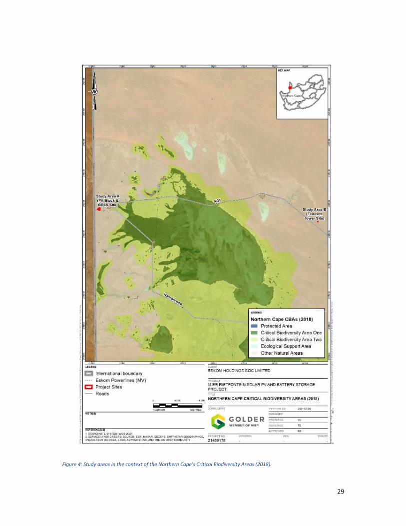
ecosystems. The Northern Cape Critical Biodiversity Areas map (2018) indicates that both study
areas and most of the surrounding landscape are categorised as ‘Other Natural Areas’ the lowest
priority category for non‐transformed land.
Two vegetation communities were identified in study area A during the field visit. These are
Rhigozum trichotomum – Stipagrostis Shrubland and Ephemeral Vegetation. The former community
is the largest, covering approximately 17.3 ha of this study area. Ephemeral Vegetation comprises
approximately 1.9 ha. Both communities are characterised by open‐ to sparse shrubland, comprising
3
of both woody and herbaceous vegetation. Rhigozum trichotomum – Stipagrostis Shrubland is a
uniform vegetation community and well‐represented across the surrounding landscape. It was rated
as having a moderate biodiversity sensitivity. Ephemeral Vegetation plays a more important
functional role in ecosystem dynamics, and accordingly was rated as having high biodiversity
sensitivity. Vegetation in the study area B landscape is characterised by open, arid shrubland that is
typical of the Gordonia Plains Shrubland vegetation type
Two flora species (Commiphora glandulosa and Hoodia gordonii) recorded during the filed visit are
listed as protected at a provincial and/or national level. Commiphora glandulosa is listed as
protected at a provincial level and was recorded in study area A. Hoodia gordonii was recorded
adjacent to the study area A, and is listed as a nationally protected species, according to the NEMBA
ToPS (2007) list and a specially protected according to the Northern Cape Nature Conservation Act
(2009). Based on available literature, additional flora species of conservation concern that may be
present, particularly in the study area B landscape, include nationally protected trees such as Boscia
albitrunca and Vachellia erioloba.
Mammal species confirmed to occur in and/or adjacent to study area A during the field visit include
Cape or Scrub Hare (Lepus capensis/saxatilis), Ground Squirrel (Xerus inauris), Aardvark (Orycteropus
afer), Cape serotine (Neoromicia capensis) and possibly the Egyptian slit‐faced bat (Nycteris
thebaica). Three reptile species were recorded in the study area during the field visit, namely the
Anchieta’s Agama (Agama anchietae), Plain Sand Lizard (Pedioplanis inornata) and Namaqua Sand
Lizard (Pedioplanis namaquensis).
Several negative impacts on terrestrial ecology associated with the proposed Project have been
identified. Of these, the loss and modification of natural habitat resulting from vegetation clearing
and earth works during construction is the primary impact of concern. This is mainly a concern for
the Solar PV and Battery Storage System site, where 10 ha of natural habitat will be cleared. Prior to
mitigation this impact at this site will have a high impact significance and will impact all flora in the
development footprint and all fauna that use these habitats as a foraging/breeding/refugia resource
on‐site. This impact can be reduced to a moderate significance by, inter alia, positioning all proposed
Project infrastructure outside a 10 m buffer around areas of ephemeral vegetation in the study area,
and limiting the extent of vegetation clearing to the minimum required for construction purposes.
To address the remaining residual impacts of habitat loss, additional conservation actions should be
investigated and implemented. These should include actively controlling alien invasive flora species
(Prosopis species) and implementing anti‐erosion control measures (e.g., rock packs) at select points
susceptible to erosion after heavy rains.
Several additional impacts were identified and assessed for significance, including the spread of alien
invasive species, dust generation, reduction in foraging habitat for bats, the loss of flora of
conservation concern, and the killing/ injuring and disturbance of fauna (including bats). With the
successful implementation of the recommended mitigation and management measures, these can
be reduced to a low impact significance.
Based on the findings of this study, provided that the mitigation measures and monitoring
requirements detailed in this report are adhered to, the Project may be authorised from a terrestrial
ecology perspective.
4
Details of the Expertise of the Specialist Specialist Information
Name Andrew Zinn Pr.Sci.Nat. ‐ Ecological Science (400687/15)
Qualifications M.Sc. Resource Conservation Biology B.Sc. Hons. Ecology and Conservation Biology B.Sc. Zoology and Grassland Science
Summary of Past Experience
Andrew Zinn is a terrestrial ecologist with Hawkhead Consulting. In this role, he conducts varied specialist ecology studies, including flora and fauna surveys, for baseline ecological assessments and ecological impact assessments. He has over a decade of experience working in the fields of ecology and conservation research. He has worked on projects in several African countries including Botswana, Democratic Republic of Congo, Ethiopia, Ghana, Mozambique, South Africa, Tanzania and Zambia.
Declaration of Independence by Specialist I, Andrew Zinn, declare that I –
Act as the independent specialist for the undertaking of a specialist section for the proposed
Rietfontein Solar PV, Battery Storage and Telecom Tower Project;
Do not have and will not have any financial interest in the undertaking of the activity, other
than remuneration for work performed;
Do not have, nor will have, a vested interest in the proposed activity proceeding;
Have no, and will not engage in, conflicting interests in the undertaking of the activity; and
Undertake to disclose, to the competent authority, any information that have or may have
the potential to influence the decision of the competent authority or the objectivity of any
Details of the Expertise of the Specialist ................................................................................................ 4
Declaration of Independence by Specialist ............................................................................................. 4
List of Figures .......................................................................................................................................... 7
List of Tables ........................................................................................................................................... 8
Acronyms and Abbreviations .................................................................................................................. 9
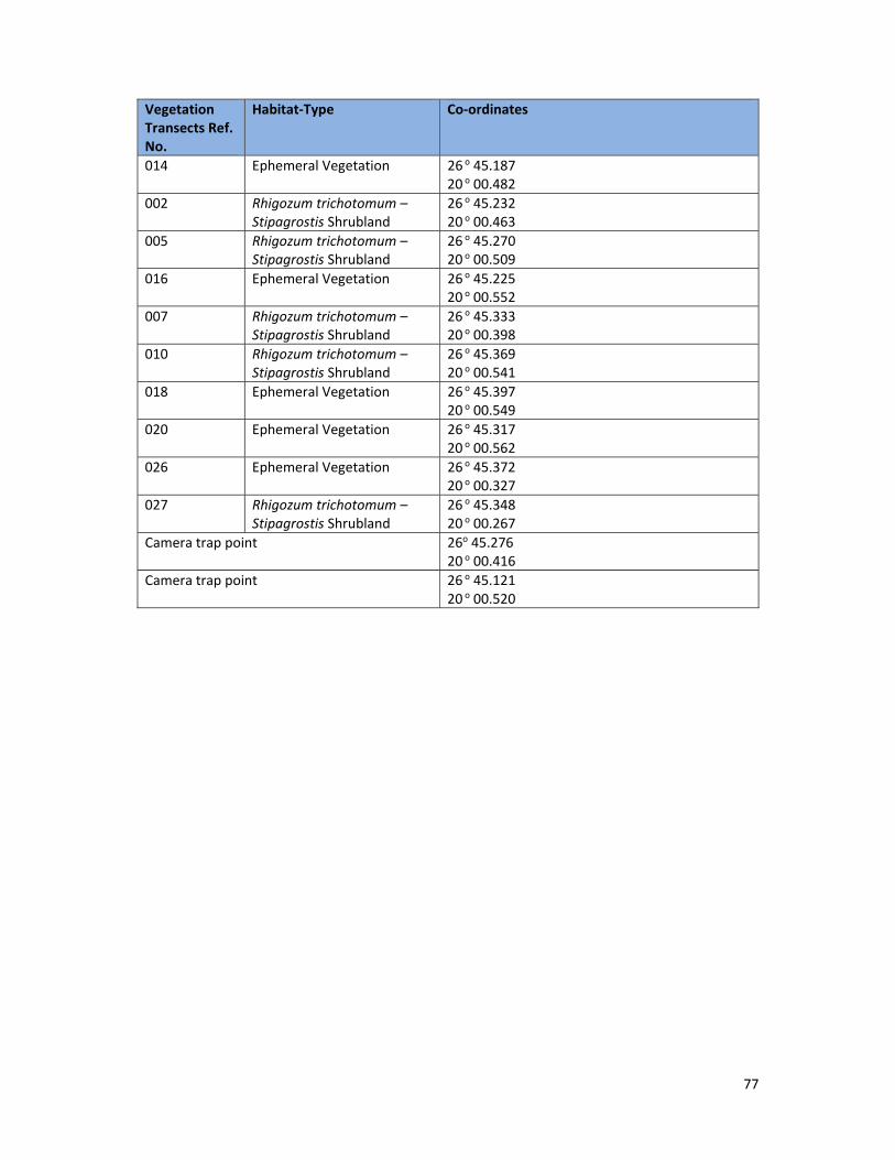
Appendix A ............................................................................................................................................ 76
Co‐ordinates of the vegetation transects and camera trap points....................................................... 76
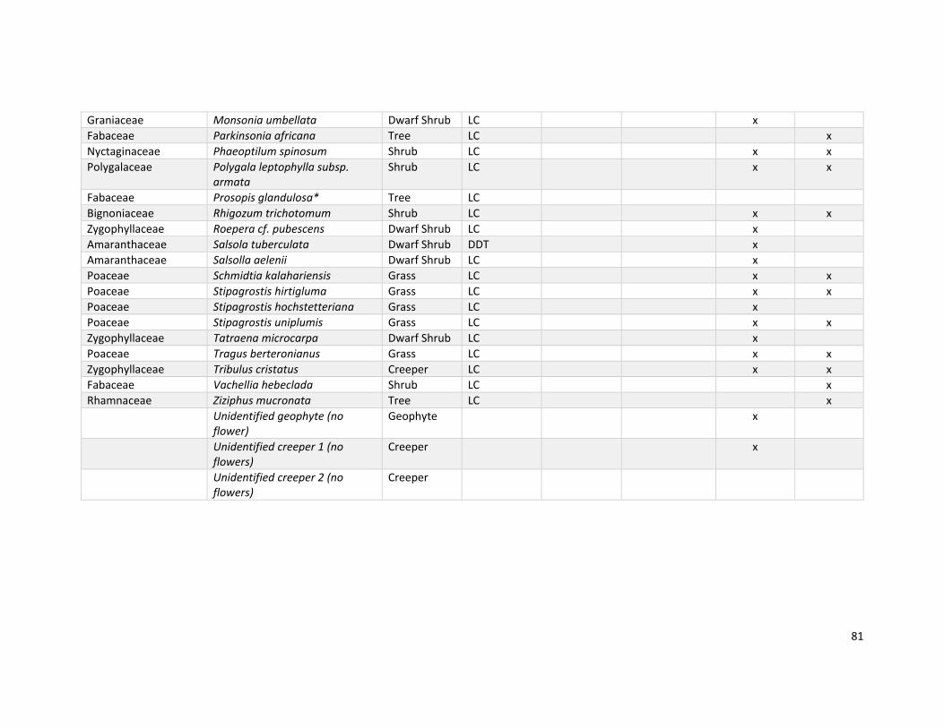
Appendix B ............................................................................................................................................ 79
List of flora species recorded in study area A during the field visit ...................................................... 79
Appendix C ............................................................................................................................................ 82
List of mammals occurring and potentially occurring in the region; .................................................... 82
and ........................................................................................................................................................ 82
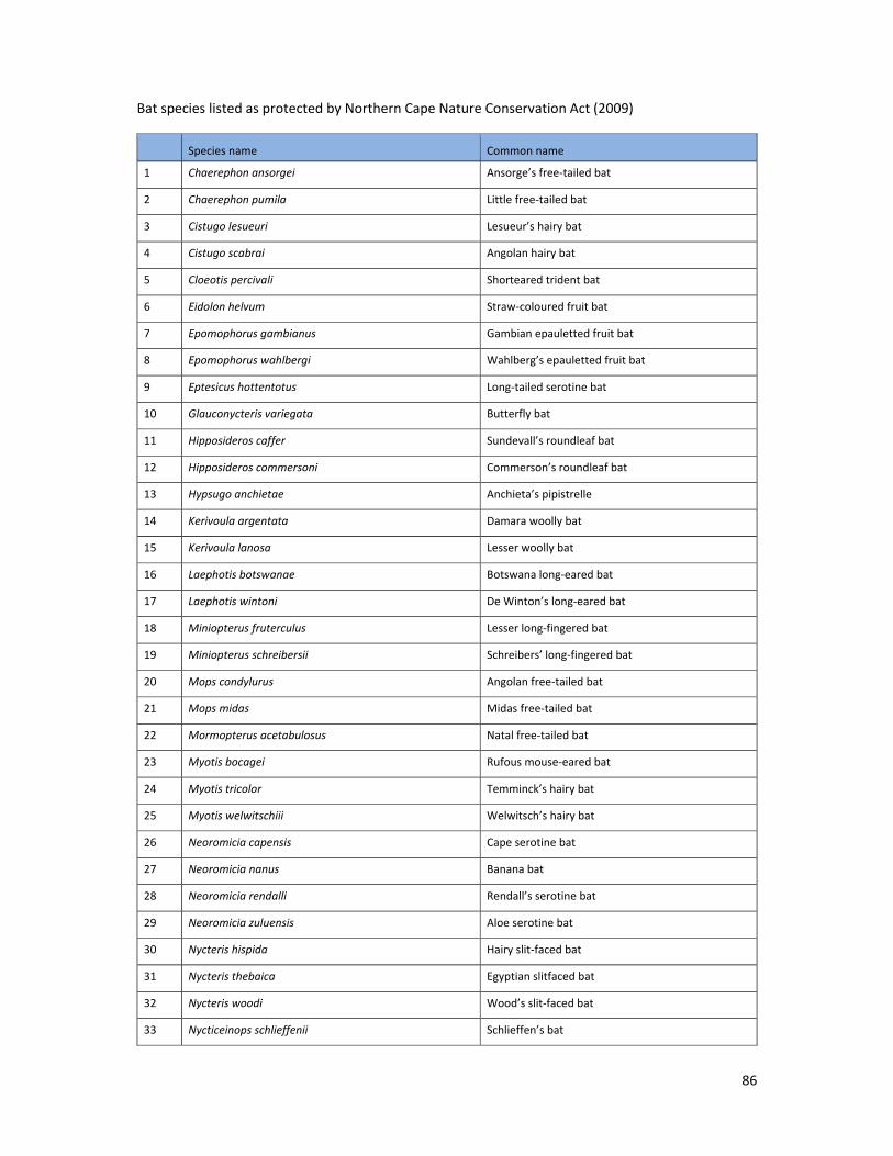
List of bat species listed as protected by Northern Cape Nature Conservation Act ............................ 82
Appendix D ............................................................................................................................................ 88
List of reptiles and amphibians occurring and potentially occurring in the region. ............................. 88
List of Figures Figure 1: Regional location of the study areas. ..................................................................................... 14
Figure 2: Study areas in relation to the Mucina and Rutherford (2011) regional vegetation types. ... 26
Figure 3: Study areas and the delineation of nationally threatened ecosystems. ............................... 28
Figure 4: Study areas in the context of the Northern Cape's Critical Biodiversity Areas (2018). ......... 29
Figure 5: Land cover of the study areas and surrounding landscape. .................................................. 31
Figure 6: Dry drainage channel to the to the north of study area A. .................................................... 32
Figure 7: Farm dam located along the drainage channel, downstream (south‐east) of study area A. 32
Figure 8: Cattle observed grazing in sandy grassland to the south‐east of study area A. .................... 32
Figure 9: Cattle and sheep farm on which study area B is located. ...................................................... 32
Figure 10: Vegetation map of study area A. ......................................................................................... 34
Figure 20: Aardvark (Orycteropus afer) burrow recorded in sandy habitat to the south‐east of study
area A. ................................................................................................................................................... 42
Figure 21: Sonogram depicting classic 'hockey stick' shape of vesper bat call. .................................... 46
Figure 22: Biodiversity sensitivity of study area A in relation to the proposed infrastructure layout. 51
List of Tables Table 1: Information to be included in specialist report. ..................................................................... 10
Table 2: Criteria for rating habitat sensitivity ....................................................................................... 20
Table 3: Matrix used to derive a Biodiversity Sensitivity Score ............................................................ 22
Table 4: Flora species listed as nationally and/or provincially Protected or Specially Protected that
may occur in the study areas. ............................................................................................................... 40
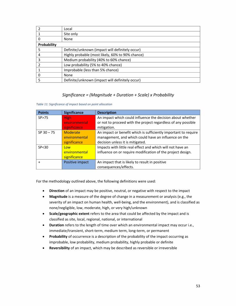
Table 11: Significance of impact based on point allocation ................................................................. 53
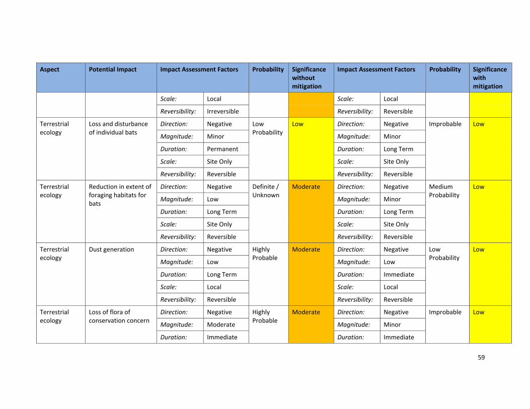
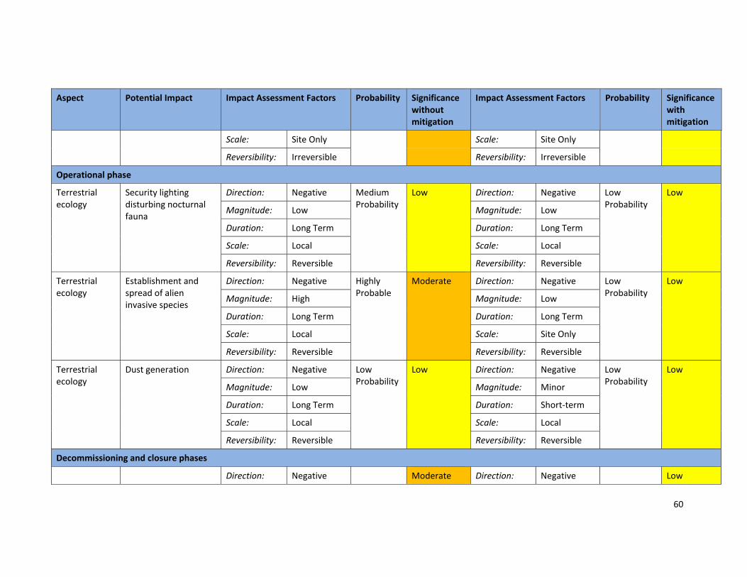
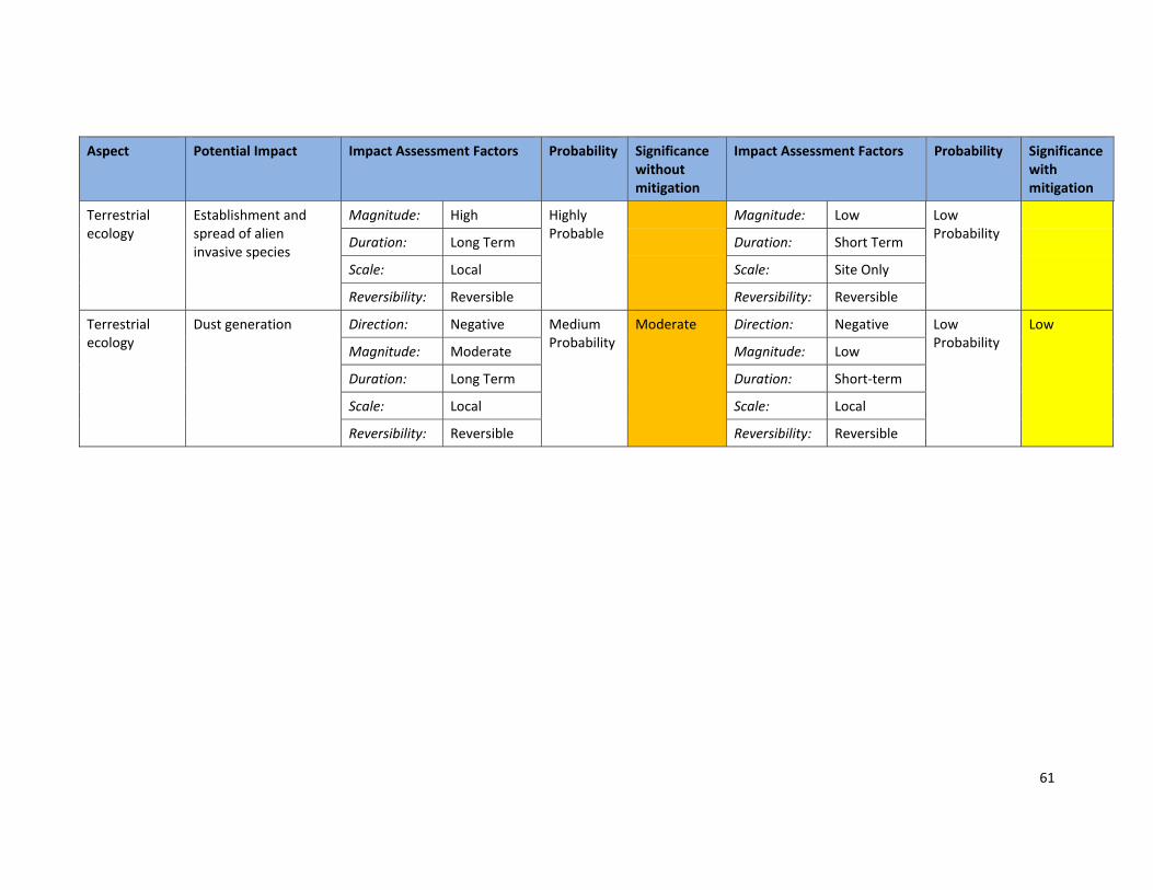
Table 12: Summary of the potential impacts/risks during the construction, operational,
decommissioning and closure phases. ................................................................................................. 58
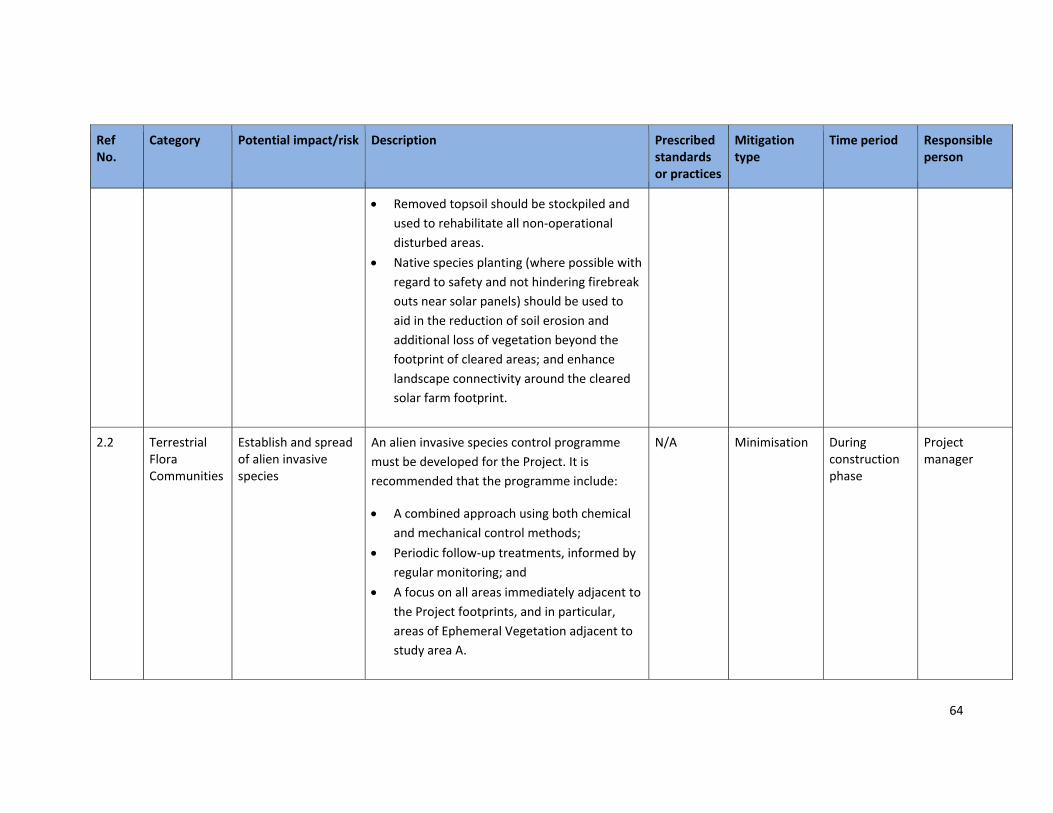
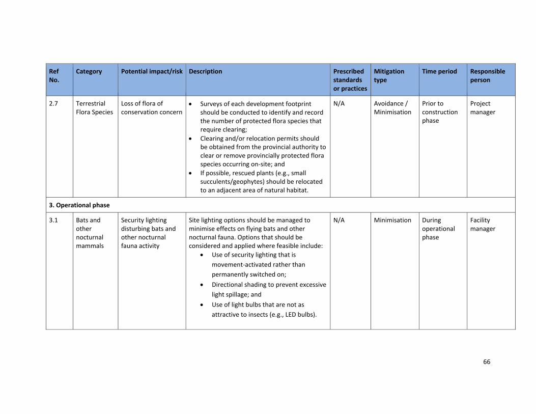
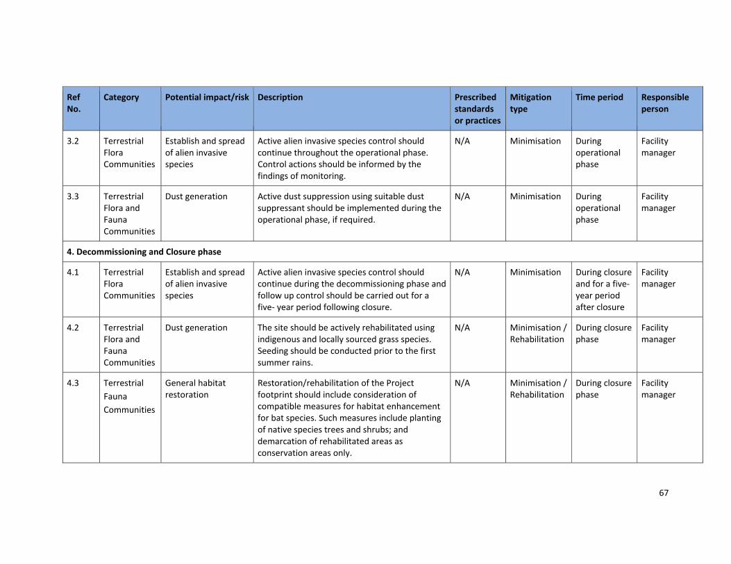
Table 13: Summary of proposed impact mitigation actions. ................................................................ 63
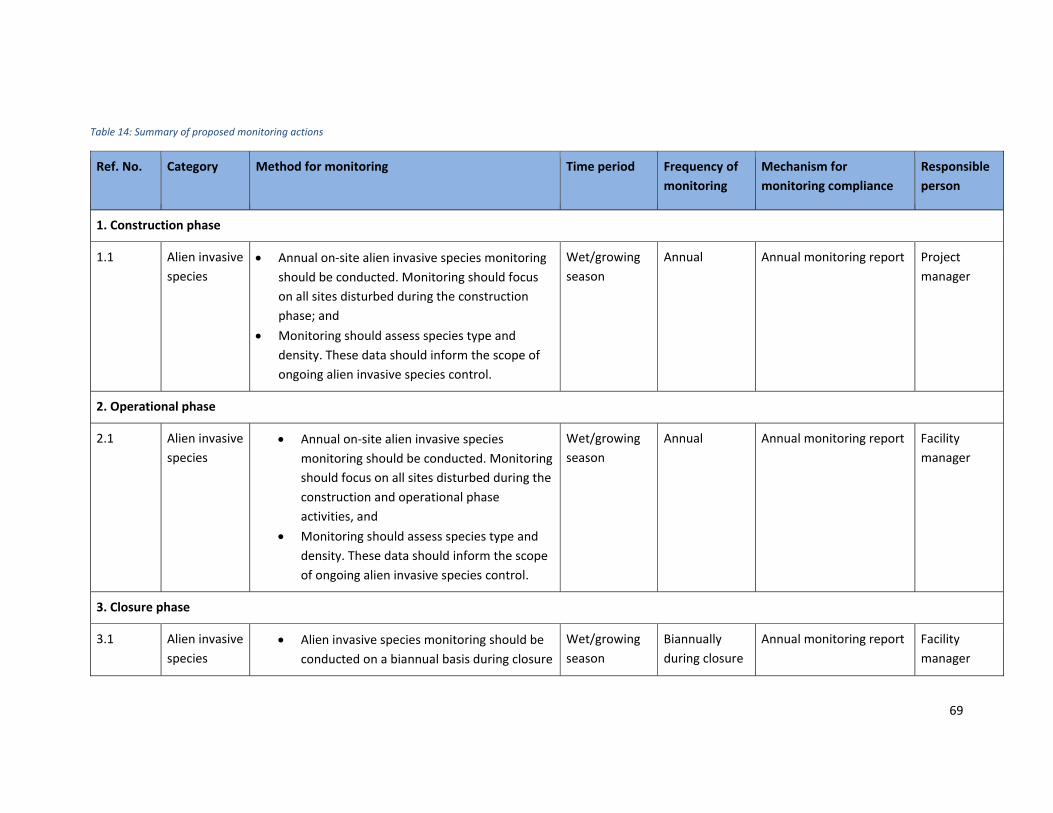
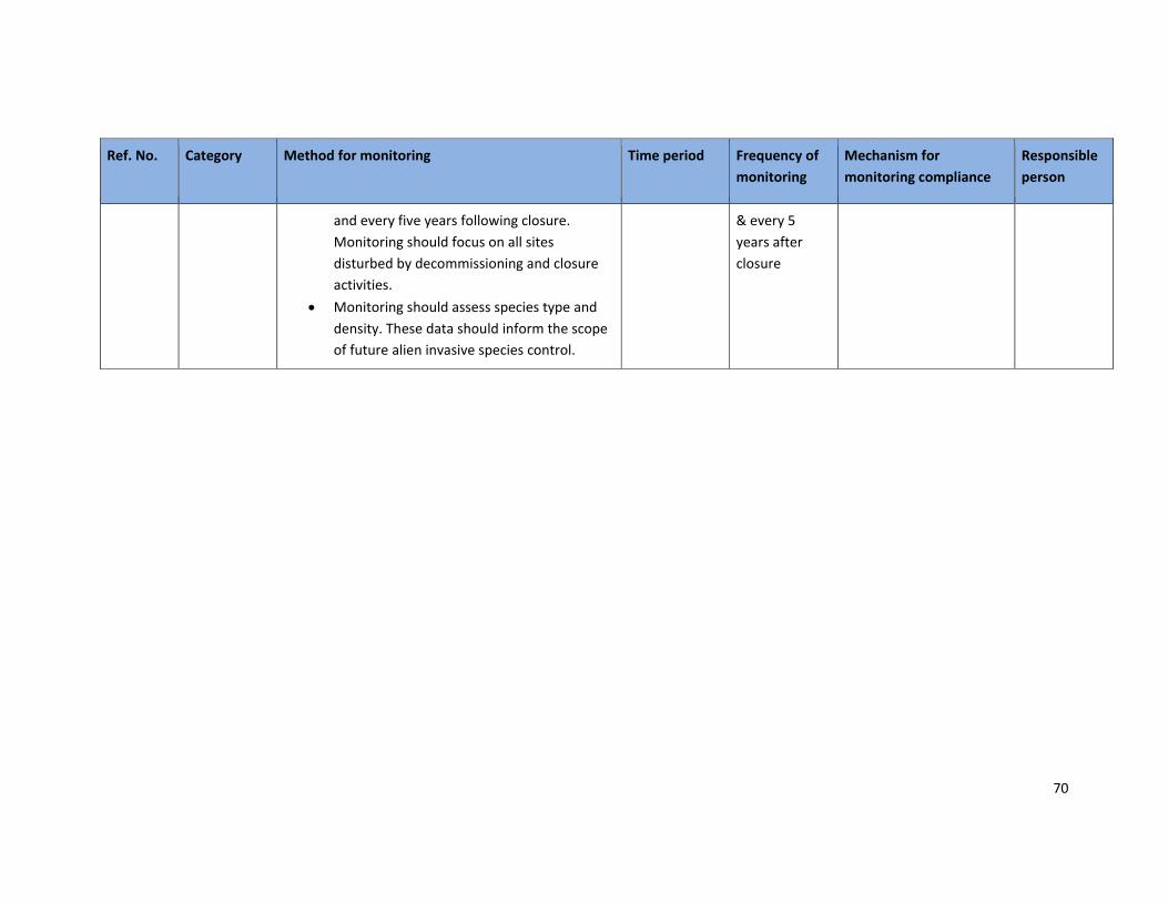
Table 14: Summary of proposed monitoring actions ........................................................................... 69
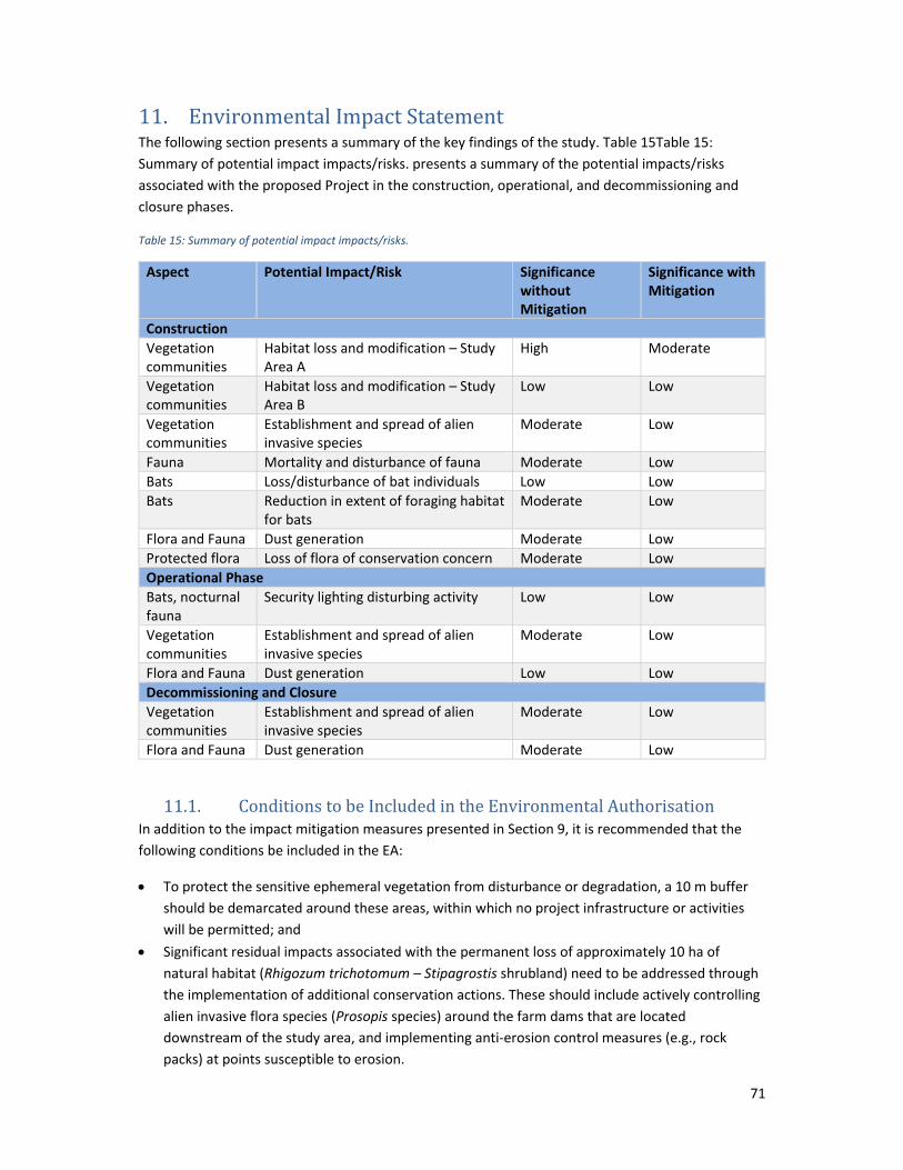
Table 15: Summary of potential impact impacts/risks. ........................................................................ 71
9
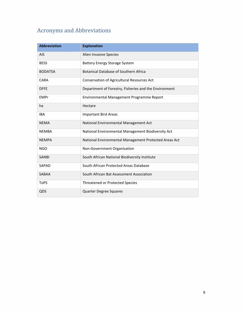
Acronyms and Abbreviations
Abbreviation Explanation
AIS Alien Invasive Species
BESS Battery Energy Storage System
BODATSA Botanical Database of Southern Africa
CARA Conservation of Agricultural Resources Act
DFFE Department of Forestry, Fisheries and the Environment
EMPr Environmental Management Programme Report
ha Hectare
IBA Important Bird Areas
NEMA National Environmental Management Act
NEMBA National Environmental Management Biodiversity Act
NEMPA National Environmental Management Protected Areas Act
NGO Non‐Government Organisation
SANBI South African National Biodiversity Institute
SAPAD South African Protected Areas Database
SABAA South African Bat Assessment Association
ToPS Threatened or Protected Species
QDS Quarter Degree Squares
10
1. Introduction Hawkhead Consulting was appointed by Golder Associates Africa (Pty) Ltd (“Golder”) on behalf of
Eskom Holdings SOC Ltd (“Eskom”) to undertake a terrestrial ecology assessment to inform a basic
assessment (“BA”) process for the proposed Mier Rietfontein Solar PV, Battery Storage and
Telecommunications Tower Project (hereafter referred to as the “Project”).
2. This Report The purpose of this report is to present a baseline terrestrial ecology characterisation of the
proposed Project footprints (hereafter referred to as the “Study Area(s)”) and conduct an impact
assessment of proposed Project activities to inform the BA process.
The scope of work of this specialist study is as follows:
Collate and review existing ecosystem and flora and fauna data pertaining to the study
areas;
Conduct a field survey to collect data on on‐site flora and fauna communities;
Assess potential negative impacts that may result from proposed Project activities;
Recommend mitigation and management measures for inclusion in the Project’s
Environmental Management Programme (EMP).
This specialist report will be included in the basic assessment report (“BAR”) submitted to the
authorities, the National Department of Forestry, Fisheries and the Environment (“DFFE”) in support
of the application for environmental authorisation (“EA”) for the proposed Project.
2.1. Structure of this Report The structure of this report is largely based on the information requirements set out in the protocols
and minimum report content requirements for environmental impacts on terrestrial animal species,
terrestrial plant species (NEMA Section 24, No. 43855) and terrestrial biodiversity (NEMA Section 24,
No. 43110).
The National Web‐based Environmental Screening Tool characterised the Animal Species Theme,
Plant Species Theme and Terrestrial Biodiversity Theme for the site as ‘Low Sensitivity’. The
terrestrial ecology assessment was thus conducted in line with the procedures for assessment and
minimum criteria for reporting on these themes.
Table 1 provides a summary of report structure.
Table 1: Information to be included in specialist report.
Section Requirements Section addressed in report
1.(1) A specialist report prepared in terms of these Regulations must contain
(a) Details of
(i) the specialist who prepared the report; and Preceding Page
(ii) the expertise of that specialist to compile a specialist report including a curriculum vitae
Preceding Page
(b) a declaration that the specialist is independent in a form as may be specified by the competent authority
Preceding Page
11
(c) an indication of the scope of, and the purpose for which, the report was prepared;
Section 1.0 and 2.0
(cA) an indication of the quality and age of base data used for the specialist report;
Section 5.0
(cB) a description of existing impacts on the site, cumulative impacts of the proposed development and levels of acceptable change;
Section 7.0
(d) the duration, date and season of the site investigation and the relevance of the season to the outcome of the assessment;
Section 5.2
(e) a description of the methodology adopted in preparing the report or carrying out the specialised process inclusive of equipment and modelling used;
Section 5.0
(f) details of an assessment of the specific identified sensitivity of the site related to the proposed activity or activities and its associated structures and infrastructure, inclusive of a site plan identifying site alternatives;
Section 8.0
(g) an identification of any areas to be avoided, including buffers;
Section 8.0
(h) a map superimposing the activity including the associated structures and infrastructure on the environmental sensitivities of the site including areas to be avoided, including buffers;
Section 8.0
(i) a description of any assumptions made and any uncertainties or gaps in knowledge;
Section 11.0
(j) a description of the findings and potential implications of such findings on the impact of the proposed activity (including identified alternatives on the environment) or activities;
Section 8.0
(k) any mitigation measures for inclusion in the EMPr;
Section 9.0
(l) any conditions for inclusion in the environmental authorisation;
Section 11.0
(m) any monitoring requirements for inclusion in the EMPr or environmental authorisation;
Section 10.0
(n) a reasoned opinion—
(i) (as to) whether the proposed activity, activities or portions thereof should be authorised;
Section 11.0
(iA) regarding the acceptability of the proposed activity or activities; and
(ii) if the opinion is that the proposed activity, activities or portions thereof should be authorised, any avoidance, management and mitigation measures that should be included in the EMPr, and where applicable, the closure plan;
(o) a description of any consultation process that was undertaken during the course of preparing the specialist report;
N/A
12
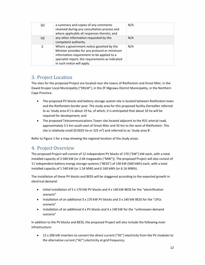
(p) a summary and copies of any comments received during any consultation process and where applicable all responses thereto; and
N/A
(q) any other information requested by the competent authority.
N/A
2. Where a government notice gazetted by the Minister provides for any protocol or minimum information requirement to be applied to a specialist report, the requirements as indicated in such notice will apply.
N/A
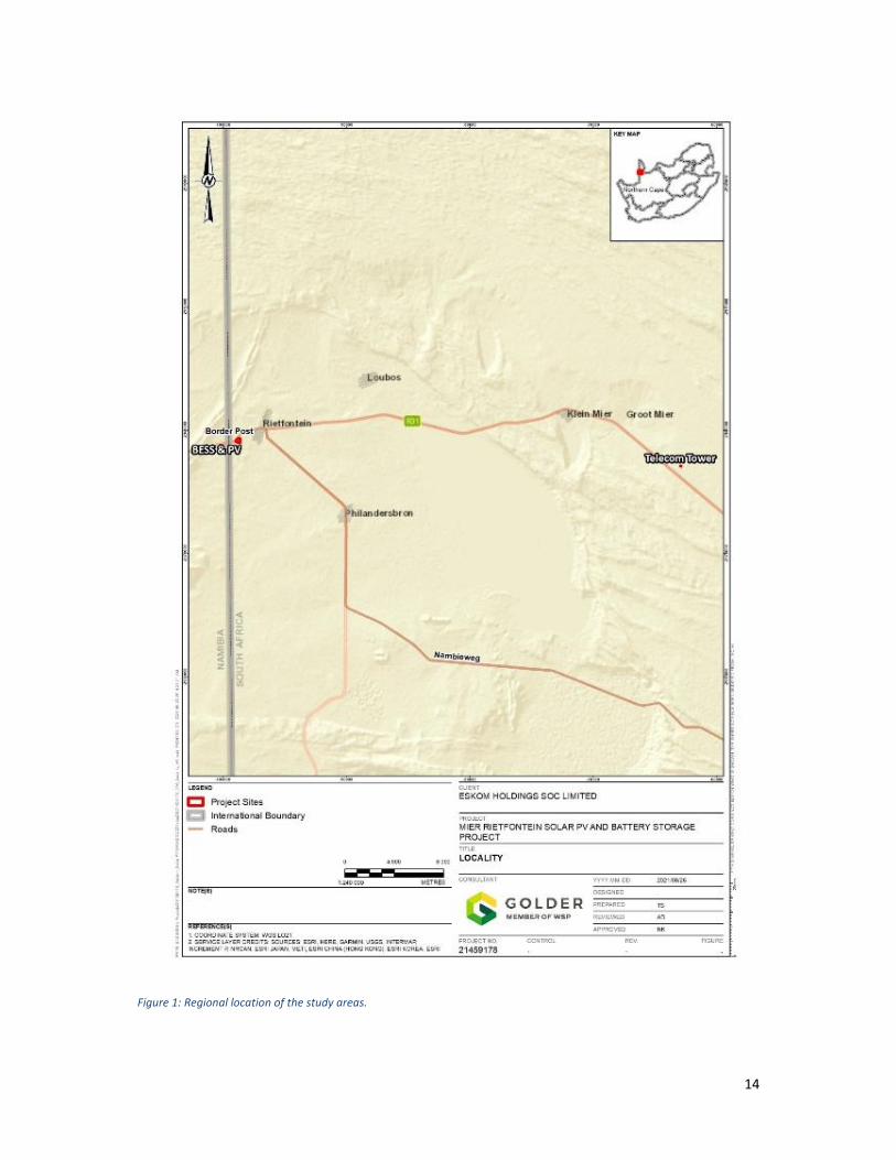
3. Project Location The sites for the proposed Project are located near the towns of Rietfontein and Groot Mier, in the
Dawid Kruiper Local Municipality (“DKLM”), in the ZF Mgcawu District Municipality, in the Northern
Cape Province.
The proposed PV blocks and battery storage system site is located between Rietfontein town
and the Rietfontein border post. The study area for this proposed facility (hereafter referred
to as ‘study area A’) is about 19 ha, of which, it is anticipated that about 10 ha will be
required for development; and
The proposed Telecommunications Tower site located adjacent to the R31 arterial road,
approximately 5.5 km south‐east of Groot Mier and 35 km to the west of Rietfontein. This
site is relatively small (0.0025 ha or 225 m2) and referred to as ‘study area B’.
Refer to Figure 1 for a map showing the regional location of the study areas.
4. Project Overview The proposed Project will consist of 12 independent PV blocks of 170 (“kW”) kW each, with a total
installed capacity of 2 040 kW (or 2.04 megawatts (“MW”)). The proposed Project will also consist of
11 independent battery energy storage systems (“BESS”) of 140 kW (560 kWh) each, with a total
installed capacity of 1 540 kW (or 1.54 MW) and 6 160 kWh (or 6.16 MWh).
The installation of these PV blocks and BESS will be staggered according to the expected growth in
electrical demand:
Initial installation of 5 x 170 kW PV blocks and 4 x 140 kW BESS for the “electrification
scenario”
Installation of an additional 3 x 170 kW PV blocks and 3 x 140 kW BESS for the “LPUs
scenario”
Installation of an additional 4 x PV blocks and 4 x 140 kW for the “unforeseen demand
scenario”
In addition to the PV blocks and BESS, the proposed Project will also include the following main
infrastructure:
12 x 200 kW inverters to convert the direct current (“DC”) electricity from the PV modules to
the alternative current (“AC”) electricity at grid frequency;
13
12 x LV/MV step‐up transformers to step up the voltage from low voltage (“LV”) at the
output of the inverter to the required medium voltage (“MV”) at the point of connection;
Transmission Yard and underground cables to connect the proposed PV and BESS to the
Mier switching station, and overhead cables connecting to the Rietfontein 33kV feeder;
Admin Block, Control & Storeroom, Workshop & Storeroom, and parking area; and
Access road, service road, and internal roads (all gravel).
The Telecommunications (Telecom) Tower development will include a 50 m high tower with four
communication dishes. The tower will be linked to an equipment container via a feeder gantry. All
infrastructure will be positioned within a 225 m2 site (0.0025 ha), that will be enclosed with a fence.
14
Figure 1: Regional location of the study areas.
15
5. Approach and Methodology The terrestrial ecology assessment took cognisance of Government Notice No. 320, published in
2020 under the National Environmental Management Act (1998) concerning ‘Procedures for the
Assessment and Minimum Criteria for Reporting on Identified Environmental Theme in terms of
Sections 24(5)(a) and (h) and 44 of the National Environmental Management Act (1998), when
applying for Environmental Authorisation’.
Prior to commencing with the terrestrial ecology assessment, the site was assessed using the
National Web‐based Environmental Screening Tool. The screening tool characterised the Animal
Species Theme, Plant Species Theme and Terrestrial Biodiversity Theme for the site as ‘Low
Sensitivity’.
In line with the assessment and reporting requirements, the terrestrial ecology assessment included
two main study components; a desktop literature review, followed by a field programme. The
objectives and tasks associated with these components are described below:
5.1. Literature Review The aim of the desktop literature review component was to collate and review pertinent ecological
information related to biodiversity and conservation features in the landscape, key ecological
processes and function, and the likely composition and structure of local flora and fauna
communities.
5.1.1. Ecosystem Attributes and Conservation Context General habitat descriptions relevant to the study areas and the surrounding region were
obtained from Mucina and Rutherford (2011);
The formal conservation context of the region at a provincial and national level was
established based on:
o The Northern Cape Critical Biodiversity Map (2018);
o The National List of Threatened Ecosystems (NEMBA Threatened Ecosystems, 2018);
The presence of protected areas in the broader region was determined based on the South
African Protected Areas Database website (SAPAD, 2021). This database contains a register
of protected areas (legally gazetted) and conservation areas (managed for biodiversity
conservation, but not legally declared) in South Africa; and
The presence of Important Bird Areas (IBA) in the region was also determined by consulting
(Marnewick, et al., 2015). Birds have been shown to be good indicators of biodiversity
hotspots. The identification and conservation of IBA’s therefore plays an important role in
broader biodiversity conservation (Marnewick, et al., 2015).
5.1.2. General Floristics A list of flora species that have previously been recorded in the region encompassing the study
areas and that may therefore occur at these sites was obtained from the SANBI’s online
Botanical Database of Southern Africa (BODATSA); and
To determine the conservation status of flora species that are potentially present, the list was
cross‐referenced against both national and Northern Cape lists of threatened and/or protected
flora (refer to Section 5.2.3).
16
5.1.3. Fauna Communities Mammals-General
A list of mammals that are known to occur in the broader region was compiled based on the
historic distribution ranges in Stuart and Stuart (2007); and
These were cross‐referenced with mammal species listed for the Quarter Degree Squares
(QDS) 2620CA, 2620CC and 2620CD on the MammalMAP database (FitzPatrick Institute of
African Ornithology, 2021).
Bats
A literature review of available information on bat presence and diversity within the general
region was conducted. Reviewed data included international and South African Red Lists
(IUCN, 2021‐1; Child et al., 2016) for bat species present in the region, bat species
distribution maps for South Africa (Monadjem et al., 2010), and any other available
information on bat presence in the region; and
Bat species and bat‐supporting habitats with potential to occur in the study areas, as well
existing threats or pressures to such species were identified through review of background
biodiversity reports relating to the Project, available published literature, consideration of
South Africa’s national and provincial biodiversity legislation and policies as they pertain to
5.2.3.2. HabitatSuitabilityAssessmentsforSpeciesofConservationConcernBased on the lists of species of conservation concern potentially present, a ‘probability of
occurrence’ of a species in the study areas was determined by conducting habitat suitability
assessments. This was done only for those species considered threatened/near threatened or
protected at a national level. The following parameters were used in the assessments:
Habitat requirements: Most threatened and endemic species have very specific habitat
requirements. The presence of these habitats in the study areas was evaluated;
Habitat status: The status or ecological condition of available habitat in the area was
assessed. Often a high level of habitat degradation will negate the potential presence of
sensitive species; and
Habitat linkage: Dispersal and movement between natural areas for breeding and feeding
are important population‐level processes. Habitat connectivity within the study areas and to
surrounding natural habitat and corridors was evaluated to determine the likely persistence
of species of concern in the study areas.
Probability of occurrence is presented in the following categories:
Confirmed: Any species of conservation concern observed/documented in the study area.
20
Probable: the species is likely to occur on the site due to suitable habitat and resources
being present on the site;
Possible: The species may occur on the site, or move through the site (in the case of mobile
species), due to potential habitat and/or resources; and
Unlikely: the species will not likely occur on the site due to lack of suitable habitat and
resources, or significant differences in its Area of Occupancy (AOO)2 compared to its Extent
of Occurrence (EOO)3 .
5.2.4. Alien Invasive and Medicinal Flora Species Alien invasive plant species were categorised according to the National Environmental
Management: Biodiversity Act (NEMBA) (Act No. 10 of 2004) ‐ 2016 listing of declared alien
invasive species; and
Flora of medicinal value were based on the purported uses described in Van Wyk, et al.,
(2009).
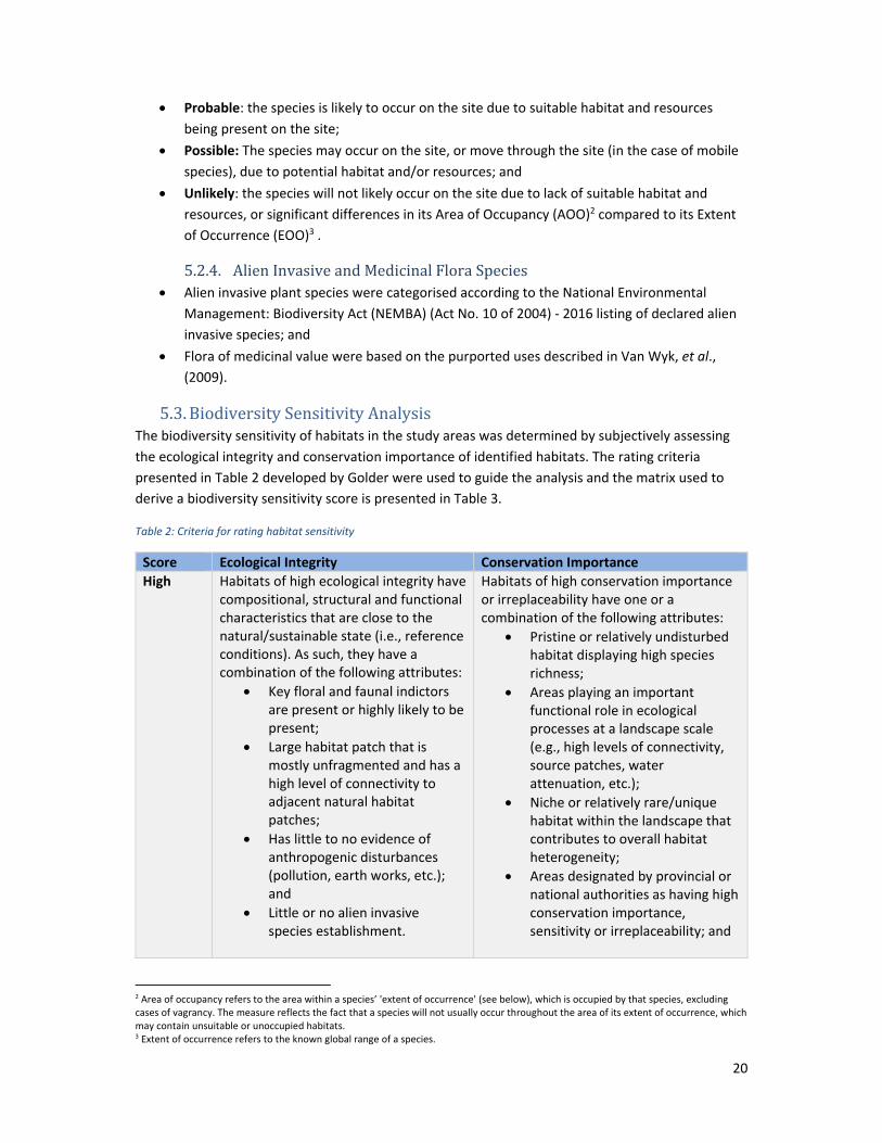
5.3. Biodiversity Sensitivity Analysis The biodiversity sensitivity of habitats in the study areas was determined by subjectively assessing
the ecological integrity and conservation importance of identified habitats. The rating criteria
presented in Table 2 developed by Golder were used to guide the analysis and the matrix used to
derive a biodiversity sensitivity score is presented in Table 3.
High Habitats of high ecological integrity have compositional, structural and functional characteristics that are close to the natural/sustainable state (i.e., reference conditions). As such, they have a combination of the following attributes:
Key floral and faunal indictors are present or highly likely to be present;
Large habitat patch that is mostly unfragmented and has a high level of connectivity to adjacent natural habitat patches;
Has little to no evidence of anthropogenic disturbances (pollution, earth works, etc.); and
Little or no alien invasive species establishment.
Habitats of high conservation importance or irreplaceability have one or a combination of the following attributes:
Pristine or relatively undisturbed habitat displaying high species richness;
Areas playing an important functional role in ecological processes at a landscape scale (e.g., high levels of connectivity, source patches, water attenuation, etc.);
Niche or relatively rare/unique habitat within the landscape that contributes to overall habitat heterogeneity;
Areas designated by provincial or national authorities as having high conservation importance, sensitivity or irreplaceability; and
2 Area of occupancy refers to the area within a species’ 'extent of occurrence' (see below), which is occupied by that species, excluding cases of vagrancy. The measure reflects the fact that a species will not usually occur throughout the area of its extent of occurrence, which may contain unsuitable or unoccupied habitats. 3 Extent of occurrence refers to the known global range of a species.
Areas with confirmed presence or high probability of occurrence of Red List species.
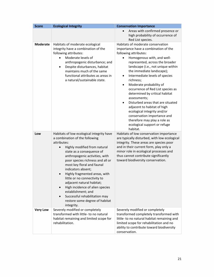
Moderate Habitats of moderate ecological integrity have a combination of the following attributes:
Moderate levels of anthropogenic disturbance; and
Despite disturbances, habitat maintains much of the same functional attributes as areas in a natural/sustainable state.
Habitats of moderate conservation importance have a combination of the following attributes:
Homogenous with, and well‐represented, across the broader landscape (i.e., not unique within the immediate landscape);
Intermediate levels of species richness;
Moderate probability of occurrence of Red List species as determined by critical habitat assessments;
Disturbed areas that are situated adjacent to habitat of high ecological integrity and/or conservation importance and therefore may play a role as ecological support or refuge habitat.
Low Habitats of low ecological integrity have a combination of the following attributes:
Highly modified from natural state as a consequence of anthropogenic activities, with poor species richness and all or most key floral and faunal indicators absent;
Highly fragmented areas, with little or no connectivity to adjacent natural habitat;
High incidence of alien species establishment; and
Successful rehabilitation may restore some degree of habitat integrity.
Habitats of low conservation importance are typically disturbed, with low ecological integrity. These areas are species poor and in their current form, play only a minor role in ecological processes and thus cannot contribute significantly toward biodiversity conservation.
Very Low Severely modified or completely transformed with little‐ to no natural habitat remaining and limited scope for rehabilitation.
Severely modified or completely transformed completely transformed with little‐ to no natural habitat remaining and limited scope for rehabilitation and no ability to contribute toward biodiversity conservation.
22
Table 3: Matrix used to derive a Biodiversity Sensitivity Score
Biodiversity Sensitivity Conservation Importance
High Moderate Low Very Low
Ecological Integrity
High High Moderate Moderate Low
Moderate High Moderate Low Low
Low Moderate Moderate Low Very Low
Very Low Low Low Very Low Very Low
6. Applicable Legislation, Policies and Guidelines 6.1. National Legislation and Guidelines
The following national legislation were consulted during the study:
National Environmental Management Act (NEMA) (Act No. 107 of 1998) including Section
24, concerning Procedures for the assessment and minimum criteria for reporting on
identified themes in terms of Sections 24(5)(a) and (h) and 44 of the NEMA, when applying
for environmental authorisation;
o Protocol for the specialist assessment and minimum report content requirements
for environmental impacts on terrestrial animal species;
o Protocol for the specialist assessment and minimum report content requirements
for environmental impacts on terrestrial plant species;
National Environmental Management: Biodiversity Act (NEMBA) (Act No. 10 of 2004);
National Environmental Management: Protected Areas Act (NEMPA) (Act No. 57 of 2003);
Environment Conservation Act (ECA) (Act No. 73 of 1989); and
Conservation of Agricultural Resources Act (CARA) (Act No. 43 of 1983).
6.2. Provincial Legislation and Guidelines The principle provincial legislation pertaining to biodiversity conservation in the Northern Cape is the
Northern Cape Nature Conservation Act, 2009 (Act No. 9 of 2009). The Northern Cape Nature
Conservation Act makes provision for the following key aspects, and related matters:
o The sustainable utilisation of wild animals, aquatic biota and plants;
o The implementation of the Convention on International Trade in Endangered
Species of Wild Fauna and Flora;
o Offences and penalties for contravention of the Act;
o The appointment of nature conservators to implement the provisions of the Act; and
o The issuing of permits and other authorisations.
The Act lists a significant number of flora and fauna species as Specially Protected and Protected
under Schedule 1 and 2 of the Act, and which restricts the hunting, import/export, transport,
keeping, breeding or trading of listed species without a permit, with certain provisions for
landowners, hunting seasons, hunting licenses, bag limits, and acceptable hunting methods.
It is noted that many of the known distributions of species listed in the Act do not overlap with the
Northern Cape province and as such are considered highly unlikely to occur in the study areas.
23
6.3. South African Bat Assessment Association Guidance The South African Bat Assessment Association (SABAA) is a membership based non‐government
organization (NGO) which lists among its objectives the aim to ensure that any development in
South Africa proceeds with the least possible impact on bats, set standards for bat surveys, and
provide guidance in relation to bats and development.
Although the SABAA indicates that there is no evidence to suggest that photovoltaic (PV) solar
developments constructed at ground level pose a direct fatality impact on bats; there remains a
possibility that key habitats could be at risk, and as such, a specialist should conduct a site visit
during the appropriate season (SABAA, 2020).
24
7. Description of the Baseline Conditions 7.1. Regional Vegetation Characteristics
Study area A is located in the Nama‐Karoo Biome and according to the regional mapping of South
Africa’s vegetation types by Mucina and Rutherford (2011), it is characterised by Kalahari Karroid
Shrubland (NKb5) (shown in Figure 2). Study area B on the other hand, is characterised by Gordonia
Plains Shrubland (SVk16) of the Savanna Biome. Descriptions of these vegetation types, and the
Nama‐Karoo and Savanna Biomes are presented below:
7.1.1. Biome Context The Nama‐Karoo Biome is extensive and located on the central plateau of the western half of South
Africa. It is an arid biome, and apart from the Orange River, most rivers are non‐perennial (Mucina &
Rutherford, 2011). Vegetation comprises short shrubland, intermixed with grasses, succulents,
geophytes and annual forbs (Mucina & Rutherford, 2011). Floristically, this biome is not species rich
and contains no centres of plant endemism. Consistent with other arid regions, the Asteraceae,
Fabaceae and Poaceae are the dominant flora families (Mucina & Rutherford, 2011). Fire is for the
most part, extremely rare as the low and erratic rainfall results in a depauperate and discontinuous
fuel load. The arid conditions favour mostly vagile herbivores that are able to migrate large distances
in search of suitable grazing (Mucina & Rutherford, 2011).
The Savanna Biome is the largest biome in South Africa, covering approximately 35% of the country’s
land surface (Scholes and Walker, 1993). Savannas are characterised by a dominant grass layer, over‐
topped by a discontinuous, yet distinct woody plant component. Primary determinants of savanna
composition, structure and functioning are; fire, a distinct seasonal climate, substrate type, and
browsing and grazing by large herbivores (Scholes and Walker, 1993). Compositionally, Africa’s
savannas are distinguished as either fine‐leafed savannas or broad‐leafed savannas. The distribution
of these forms is based primarily on soil fertility (Scholes and Walker, 1993); fine‐leafed savannas
occur on nutrient rich soils and are dominated by microphyllous woody species of the Fabaceae
family (most commonly Acacia’s). These savannas have a productive and diverse herbaceous layer
that is dominated by grasses, and can support large populations of mammalian herbivores (Scholes
and Walker, 1993). Conversely, broad‐leafed savannas usually occur on nutrient poor soils and are
dominated by macrophyllous woody species from the Combretaceae family (common genera:
Combretum & Terminalia). Compared to fine‐leafed savannas, broad‐leafed savannas are less
productive and support a lower herbivore biomass (Scholes and Walker, 1993).
7.1.2. Kalahari Karroid Shrubland In South Africa, this vegetation community is confined to the North Cape Province, where it occurs in
belts alternating with Gordonia Duneveld on the broad plains to the north of Upington (Figure 2).
Vegetation is characterised by low karroid shrubland on flat, gravel plains. Flora species comprise
both Karoo‐related elements, as well as northern floristic elements, and thus indicates a transition
from the Karoo to the sandy soils of the Kalahari (Mucina & Rutherford, 2011). The region is
particularly dry, with mean annual precipitation (MAP) recorded at 100‐200 mm. Rainfall occurs
mainly in the late summer and early autumn. Temperatures range from a mean maximum of 39.50C
in January to a mean minimum of ‐4.20C in July (Mucina & Rutherford, 2011).
25
The geology is dominated by Cenozoic Kalahari Group sands and small patches of intermittent rivers
(known as ‘mekgacha’) occurring on calcrete outcrops and screes, and Dwyka Group tillite outcrops.
Soils are deep, red‐yellow, apedal and free draining (Mucina & Rutherford, 2011).
Mucina & Rutherford (2011) list the following flora species as being important or characteristic taxa
in the Kalahari Karroid Shrubland vegetation type:
Small Trees and Shrubs: Senegalia mellifera, Parkinsonia africana, Boscia foetida, Rhigozum
(Sagittarius serpentarius), Martial Eagle (Polemaetus bellicosus), Kori Bustard (Ardeotis kori),
Ludwig’s Bustard (Neotis ludwigii) and the Lanner Falcon (Falco biarmicus) (Marnewick, et al., 2015).
28
Figure 3: Study areas and the delineation of nationally threatened ecosystems.
29
Figure 4: Study areas in the context of the Northern Cape's Critical Biodiversity Areas (2018).
30
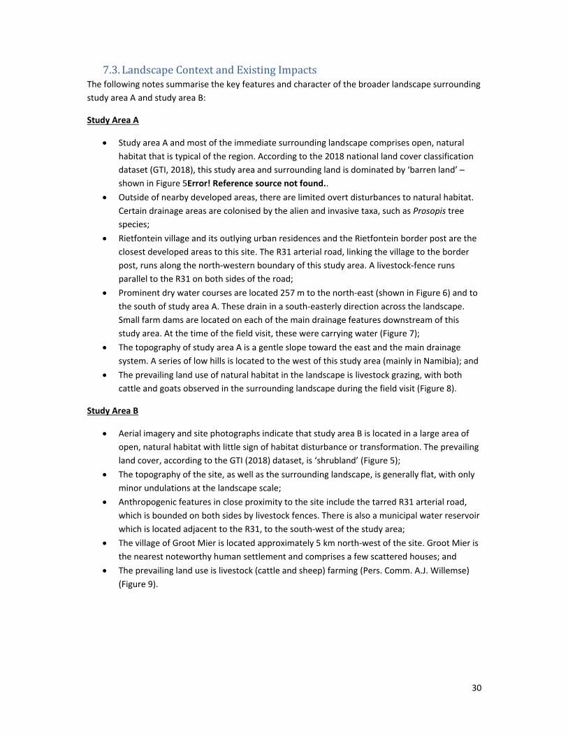
7.3. Landscape Context and Existing Impacts The following notes summarise the key features and character of the broader landscape surrounding
study area A and study area B:
Study Area A
Study area A and most of the immediate surrounding landscape comprises open, natural
habitat that is typical of the region. According to the 2018 national land cover classification
dataset (GTI, 2018), this study area and surrounding land is dominated by ‘barren land’ –
shown in Figure 5Error! Reference source not found..
Outside of nearby developed areas, there are limited overt disturbances to natural habitat.
Certain drainage areas are colonised by the alien and invasive taxa, such as Prosopis tree
species;
Rietfontein village and its outlying urban residences and the Rietfontein border post are the
closest developed areas to this site. The R31 arterial road, linking the village to the border
post, runs along the north‐western boundary of this study area. A livestock‐fence runs
parallel to the R31 on both sides of the road;
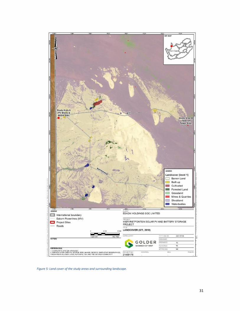
Prominent dry water courses are located 257 m to the north‐east (shown in Figure 6) and to
the south of study area A. These drain in a south‐easterly direction across the landscape.
Small farm dams are located on each of the main drainage features downstream of this
study area. At the time of the field visit, these were carrying water (Figure 7);
The topography of study area A is a gentle slope toward the east and the main drainage
system. A series of low hills is located to the west of this study area (mainly in Namibia); and
The prevailing land use of natural habitat in the landscape is livestock grazing, with both
cattle and goats observed in the surrounding landscape during the field visit (Figure 8).
Study Area B
Aerial imagery and site photographs indicate that study area B is located in a large area of
open, natural habitat with little sign of habitat disturbance or transformation. The prevailing
land cover, according to the GTI (2018) dataset, is ‘shrubland’ (Figure 5);
The topography of the site, as well as the surrounding landscape, is generally flat, with only
minor undulations at the landscape scale;
Anthropogenic features in close proximity to the site include the tarred R31 arterial road,
which is bounded on both sides by livestock fences. There is also a municipal water reservoir
which is located adjacent to the R31, to the south‐west of the study area;
The village of Groot Mier is located approximately 5 km north‐west of the site. Groot Mier is
the nearest noteworthy human settlement and comprises a few scattered houses; and
The prevailing land use is livestock (cattle and sheep) farming (Pers. Comm. A.J. Willemse)
(Figure 9).
31
Figure 5: Land cover of the study areas and surrounding landscape.
32
Figure 6: Dry drainage channel to the north of study area A.
Figure 7: Farm dam located along the drainage channel, downstream (south‐east) of study area A.
Figure 8: Cattle observed grazing in sandy grassland to the south‐east of study area A.
Figure 9: Cattle and sheep farm on which study area B is located.
33
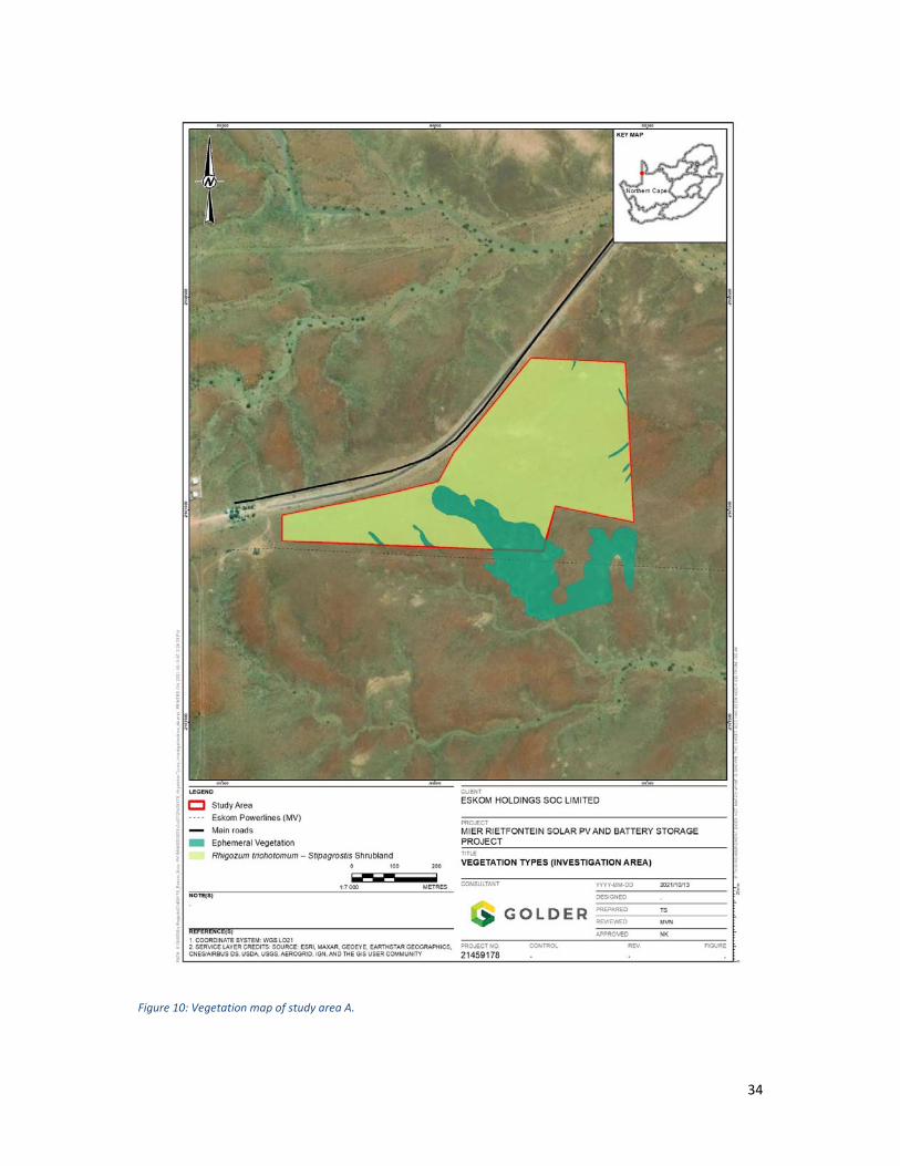
7.4. Vegetation Communities and Floristics The vegetation of study area A is fairly homogenous, with two vegetation communities identified,
namely Rhigozum trichotomum – Stipagrostis Shrubland and Ephemeral Vegetation. A description of
each community, along with representative photographs is presented in Section 7.4.1 and Section
7.4.2, with a vegetation map of study area A shown in Figure 10.
General comment, based on aerial imagery and site photographs, of the habitat characteristics of
the study area B landscape, is provided in Section 7.4.3.
34
Figure 10: Vegetation map of study area A.
35
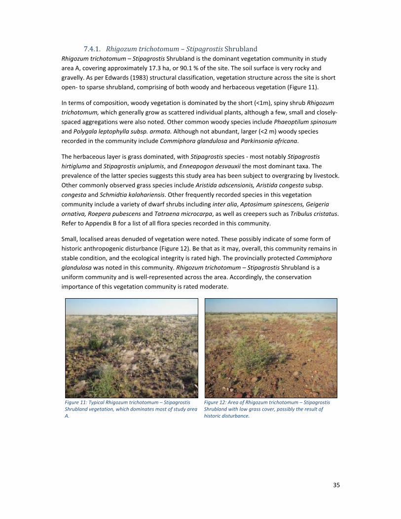
7.4.1. Rhigozumtrichotomum– Stipagrostis Shrubland Rhigozum trichotomum – Stipagrostis Shrubland is the dominant vegetation community in study
area A, covering approximately 17.3 ha, or 90.1 % of the site. The soil surface is very rocky and
gravelly. As per Edwards (1983) structural classification, vegetation structure across the site is short
open‐ to sparse shrubland, comprising of both woody and herbaceous vegetation (Figure 11).
In terms of composition, woody vegetation is dominated by the short (<1m), spiny shrub Rhigozum
trichotomum, which generally grow as scattered individual plants, although a few, small and closely‐
spaced aggregations were also noted. Other common woody species include Phaeoptilum spinosum
and Polygala leptophylla subsp. armata. Although not abundant, larger (<2 m) woody species
recorded in the community include Commiphora glandulosa and Parkinsonia africana.
The herbaceous layer is grass dominated, with Stipagrostis species ‐ most notably Stipagrostis
hirtigluma and Stipagrostis uniplumis, and Enneapogon desvauxii the most dominant taxa. The
prevalence of the latter species suggests this study area has been subject to overgrazing by livestock.
Other commonly observed grass species include Aristida adscensionis, Aristida congesta subsp.
congesta and Schmidtia kalahariensis. Other frequently recorded species in this vegetation
community include a variety of dwarf shrubs including inter alia, Aptosimum spinescens, Geigeria
ornativa, Roepera pubescens and Tatraena microcarpa, as well as creepers such as Tribulus cristatus.
Refer to Appendix B for a list of all flora species recorded in this community.
Small, localised areas denuded of vegetation were noted. These possibly indicate of some form of
historic anthropogenic disturbance (Figure 12). Be that as it may, overall, this community remains in
stable condition, and the ecological integrity is rated high. The provincially protected Commiphora
glandulosa was noted in this community. Rhigozum trichotomum – Stipagrostis Shrubland is a
uniform community and is well‐represented across the area. Accordingly, the conservation
importance of this vegetation community is rated moderate.
Figure 11: Typical Rhigozum trichotomum – Stipagrostis Shrubland vegetation, which dominates most of study area A.
Figure 12: Area of Rhigozum trichotomum – Stipagrostis Shrubland with low grass cover, possibly the result of historic disturbance.
36
7.4.2. Ephemeral Vegetation This vegetation community is associated with low points that are present in the study area A (Figure
10). These areas are characterised by sandy and possibly deeper soils, which likely retain moisture
for longer periods following rain (Figure 13 and Figure 14). Collectively, this community comprises
1.9 ha (9.9%) of study area A.
Both structurally and compositionally, vegetation in this community is similar to Rhigozum
trichotomum – Stipagrostis Shrubland community. Vegetation structure is generally short open‐ to
sparse shrubland, although in certain areas ephemeral grass productivity was notably higher than
adjacent areas of shrubland on account of the summer rains. Compositionally, Rhigozum
trichotomum and Stipagrostis grasses remain common and often dominant taxa. Other flora species
that were more prevalent in this community compared to the adjacent Rhigozum trichotomum –
Stipagrostis Shrublands, include occasional Ziziphus mucronata trees, as well as the smaller woody
species such as Catophractes alexandri, Cryptolepis decidua, Hermannia burchellii and Justicia
australis, and grasses such as Aristida congesta subsp. congesta and Eragrostis trichophora. Refer to
Appendix B for a list of all flora species recorded in this community.
This community remains in stable condition, and the ecological integrity is rated high. In an arid
region such as that where this study area is located, these features are functionally important. They
play a drainage role and increase broader landscape heterogeneity through their increased
vegetation productivity. These communities are also susceptible to alien invasive species
establishment and colonisation. Accordingly, the conservation importance of this vegetation
community is rated high.
Figure 13: Shallow poorly‐defined area of ephemeral vegetation.
Figure 14: More‐defined area of ephemeral vegetation.
37
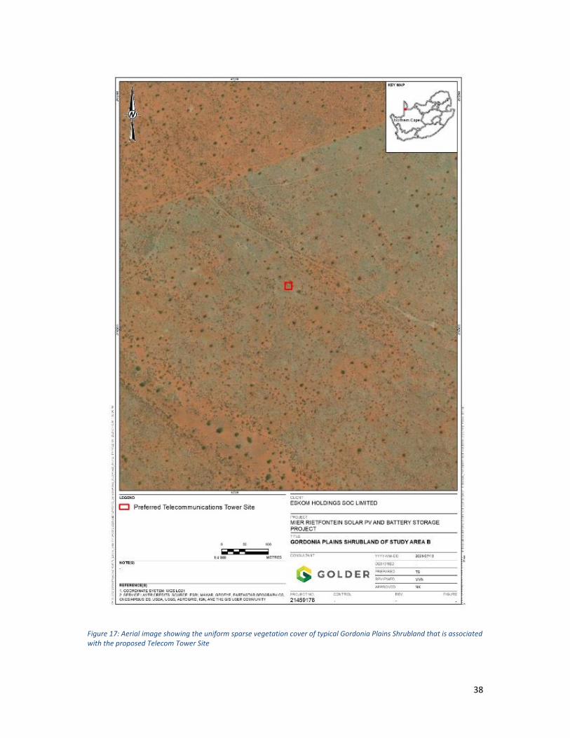
7.4.3. Habitat Characteristics of the Study Area B Landscape Based on imagery and site photographs collected by farmer Mr A.J. Willemse, the vegetation of the
study area B landscape is characterised by very open, arid shrubland occurring on red Kalahari sands
that is typical of the Gordonia Plains Shrubland vegetation type, as described by Mucina and
Rutherford (2011)
Vegetation is homogenous across the immediate landscape, with little structural variation. Woody
plants are generally short and occur as scattered individual plants, although isolated taller trees are
also present. Refer to Figure 15 and Figure 16 for landscape photographs, as well Figure 17 for an
aerial image depicting the uniform, sparse vegetation cover.
Common woody species that are noted to occur in the area include, inter alia; Boscia albitrunca,
Rhigozum trichotomum, Senegalia mellifera and Vachellia erioloba (Pers. Comm. A.J. Willemse). The
grass layer was unusually well‐developed, following the high seasonal rains (Pers. Comm. A.J.
Willemse).
Figure 15: Habitat in the study area B landscape.
Figure 16: Open, arid savanna with woody vegetation comprised of low, scattered shrubs/trees.
38
Figure 17: Aerial image showing the uniform sparse vegetation cover of typical Gordonia Plains Shrubland that is associated with the proposed Telecom Tower Site
39
7.4.4. Floristic Analysis Forty‐four flora species, representing 18 families were identified in study area A during the field visit.
The most represented family is the Poaceae with 13 species, followed by the Fabaceae with four
species. Grasses and dwarf shrubs are the most abundant growth form with 13 species recorded for
each. The next most represented growth form are trees and creepers, with four species each. Two
succulents, one herb and one geophyte were recorded (Appendix B).
7.4.4.1. FloraSpeciesofConservationConcernNone of the flora species recorded in study area A during the field visit are listed on the national Red
List. Two recorded species, namely Commiphora glandulosa and Hoodia gordonii are however, listed
as protected at a provincial and/or national level:
Commiphora glandulosa is listed, along with all Commiphora species, as protected at a
provincial level according to the Northern Cape Nature Conservation Act (2009). Small
specimens were observed in study area A.
Hoodia gordonii is listed as a nationally protected species, according to the NEMBA ToPS
(2007) list. It is also listed as specially protected at a provincial level, under the Northern
Cape Nature Conservation Act (2009). Although not recorded in study area A itself, a single
Hoodia gordonii was recorded immediately adjacent to this study area. Several specimens of
an unidentified geophyte (no flowering material) were also observed during the field visit.
These are also likely to be listed as protected on the Northern Cape Nature Conservation Act
(2009).
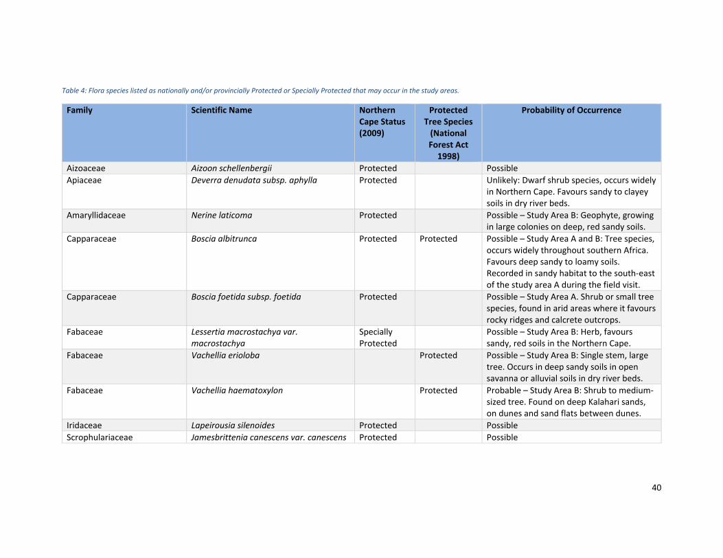
A review and cross‐referencing of flora species documented on the BODATSA database for the
broader region encompassing both study area indicates that an additional ten flora species of
conservation concern are potentially present. These include three nationally protected trees (Boscia
albitrunca, Vachellia erioloba and Vachellia haematoxylon), and seven provincially protected and
one specially protected flora species (Table 4). None of these are listed as threatened or near
threatened on the national Red List.
Based on documented habitat preferences, a probability of occurrence in the two study areas is
indicated. In instance where there is very limited species‐specific habitat information, a
precautionary approach is followed, and a species is assigned ‘possible’ probability of occurrence.
40
Table 4: Flora species listed as nationally and/or provincially Protected or Specially Protected that may occur in the study areas.
Family Scientific Name Northern Cape Status (2009)
Protected Tree Species (National Forest Act 1998)
Probability of Occurrence
Aizoaceae Aizoon schellenbergii Protected Possible
Apiaceae Deverra denudata subsp. aphylla Protected Unlikely: Dwarf shrub species, occurs widely in Northern Cape. Favours sandy to clayey soils in dry river beds.
Amaryllidaceae Nerine laticoma Protected Possible – Study Area B: Geophyte, growing in large colonies on deep, red sandy soils.
Capparaceae Boscia albitrunca Protected Protected Possible – Study Area A and B: Tree species, occurs widely throughout southern Africa. Favours deep sandy to loamy soils. Recorded in sandy habitat to the south‐east of the study area A during the field visit.
Capparaceae Boscia foetida subsp. foetida Protected Possible – Study Area A. Shrub or small tree species, found in arid areas where it favours rocky ridges and calcrete outcrops.
Fabaceae Lessertia macrostachya var. macrostachya
Specially Protected
Possible – Study Area B: Herb, favours sandy, red soils in the Northern Cape.
Fabaceae Vachellia erioloba Protected Possible – Study Area B: Single stem, large tree. Occurs in deep sandy soils in open savanna or alluvial soils in dry river beds.
Fabaceae Vachellia haematoxylon Protected Probable – Study Area B: Shrub to medium‐sized tree. Found on deep Kalahari sands, on dunes and sand flats between dunes.
Iridaceae Lapeirousia silenoides Protected Possible
Scrophulariaceae Jamesbrittenia canescens var. canescens Protected Possible
41
7.4.4.2. DeclaredAlienInvasiveSpeciesNo declared alien invasive species were recorded in study area A during the field visit. However,
Prosopis trees were abundant in and around Rietfontein village, and were also observed at fairly
high densities along the drainage features, downstream of this study area. Prosopis species (e.g., P.
glandulosa and P. velutina) are large shrubs or small trees that are declared Category 3 invasive
species in the Northern Cape, according to the NEMBA. Prosopis taxa readily hybridises with each
other where they are sympatric. They invade river channels where they can form dense thickets.
7.4.4.3. MedicinalFloraSpeciesTwo species recorded in/adjacent to study area A have medicinal value:
The succulent Hoodia gordonii, which was not recorded in study area A, but was recorded
immediately adjacent to it, is used to treat haemorrhoids, tuberculosis, diabetes,
indigestion, hypertension and stomach ache (Van Wyk, et al., 2009); and
The tree Ziziphus mucronata is used as an expectorant in cough and chest problems. It is also
used to treat, amongst other ailments diarrhoea, dysentery, boils, sores and glandular
swellings (Van Wyk, et al., 2009).
7.5. Fauna Communities 7.5.1. Mammals
7.5.1.1. MammalsPotentiallyPresentintheStudyAreaBased on historic distribution ranges presented in Stuart and Stuart (2007), up to 67 additional
mammal species (excluding bats) are known from the region (Appendix C). Several of these are large
predators and ungulates that despite their historic ranges, are likely to be mainly confined to formal
conservation areas, such as the Kalagadi Transfrontier Park, which is situated to the north of the
study areas.
7.5.1.2. MammalsRecordedintheStudyAreaThree mammal species were noted to occur in and/or adjacent to study area A during the field visit;
Cape or Scrub Hare (Lepus capensis/saxatilis)4 and Ground Squirrel (Xerus inauris) were recorded on
camera traps placed on the boundary of the study area ‐shown in Figure 18 and Figure 19, while
evidence of a Aardvark (Orycteropus afer) burrow (Figure 20) was observed close to the farm dam to
the south‐east of study area A during the field visit.
All three species are fairly common taxa, with widespread distributions and none are listed as
threatened or near threatened on the mammal Red List. However, at a provincial level, both Hare
species and the Ground squirrel are listed as ‘protected’, while the Aardvark is listed as specially
protected, according to the Northern Cape Nature Conservation Act (2009).
Despite the availability of suitable habitat in study area A and across the surrounding landscape, the
low mammal abundance and richness recorded during the field visit is not unexpected. The arid
nature of local habitat means that general mammal abundance is low. Moreover, the proximity of
Rietfontein village and its likely attendant anthropogenic pressures, such as hunting with/by
4 Camera trap images are not clear enough to positively determine which of these similar and sympatric species is present.
42
domestic and feral dogs, may also limit the extent to which mammals (such as small antelope), use
habitat between the village and border post.
Considering its remote and relatively undisturbed location, and the probable lower levels of
anthropogenic pressures, is anticipated that the mammal community associated with the study area
B landscape is likely to be more abundant and richer than that of study area A.
Figure 18: Cape or Scrub Hare (Lepus capensis/saxatilis).
Figure 19: Ground Squirrel (Xerus inauris).
Figure 20: Aardvark (Orycteropus afer) burrow recorded in sandy habitat to the south‐east of study area A.
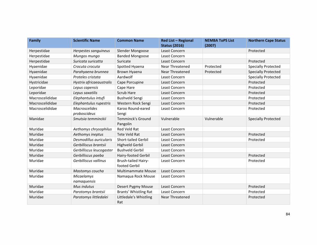
7.5.1.3. MammalsofConservationConcernOf species potentially occurring in the study areas, ten are listed as threatened or near threatened
on the national Red List and 11 are listed on the NEMBA ToPS list (2007) – refer to Table 5. Fifty‐
eight species are further listed as either ‘specially protected’ or ‘protected’ according to the
Probable ‐ Study Area A and B: Suitable habitat present and may periodically use or move through the study area. A dead individual was observed on the R31 to the east of Rietfontein.
Felidae Panthera leo Lion Least Concern Vulnerable Specially Protected
Unlikely: Large predator, Restricted to formal conservation areas.
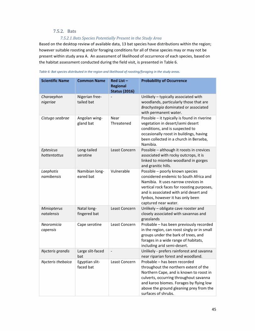
Based on the desktop review of available data, 13 bat species have distributions within the region;
however suitable roosting and/or foraging conditions for all of these species may or may not be
present within study area A. An assessment of likelihood of occurrence of each species, based on
the habitat assessment conducted during the field visit, is presented in Table 6.
Table 6: Bat species distributed in the region and likelihood of roosting/foraging in the study areas.
Scientific Name Common Name Red List – Regional Status (2016)
Probability of Occurrence
Charaephon nigeriae
Nigerian free‐tailed bat
‐ Unlikely – typically associated with woodlands, particularly those that are Brachystegia dominated or associated with permanent water.
Cistugo seabrae Angolan wing‐gland bat
Near Threatened
Possible – it typically is found in riverine vegetation in desert/semi desert conditions, and is suspected to occasionally roost in buildings, having been collected in a church in Berseba, Namibia.
Eptesicus hottentottus
Long‐tailed serotine
Least Concern Possible – although it roosts in crevices associated with rocky outcrops, it is linked to miombo woodland in gorges and granitic hills.
Laephotis namibensis
Namibian long‐eared bat
Vulnerable Possible – poorly known species considered endemic to South Africa and Namibia. It uses narrow crevices in vertical rock faces for roosting purposes, and is associated with arid desert and fynbos, however it has only been captured near water.
Miniopterus natalensis
Natal long‐fingered bat
Least Concern Unlikely – obligate cave rooster and closely associated with savannas and grasslands
Neoromicia capensis
Cape serotine Least Concern Probable – has been previously recorded in the region, can roost singly or in small groups under the bark of trees, and forages in a wide range of habitats, including arid semi‐desert.
Nycteris grandis Large slit‐faced bat
‐ Unlikely ‐ prefers rainforest and savanna near riparian forest and woodland.
Nycteris thebaica Egyptian slit‐faced bat
Least Concern Probable – has been recorded throughout the northern extent of the Northern Cape, and is known to roost in culverts, occurring throughout savanna and karoo biomes. Forages by flying low above the ground gleaning prey from the surfaces of shrubs.
46
Pipistrellus rupellii
Rüppell’s pipistrelle
Least Concern Unlikely – although an isolated record at Augrabies Falls exists, it is believed to be associated with large rivers and wetland in dry savanna or woodland habitat.
Rhinolophus darlingii
Darling’s horseshoe bat
Least Concern Probable – it has been recorded on the Namibia/South African border approx. 400 km south of the site, roosts in small groups in culverts (as well as colonies in caves) and is known to occur in arid savanna.
Rhinolophus denti Dent’s horseshoe bat
Near Threatened
Probable – it has been recorded in the northern extent of the Northern Cape, roosts in crevices in rocky outcrops and is known to roost in culverts and thatched buildings, and is associated with arid habitats.
Sauromys petrophilus
Robert’s flat‐headed bat
Least Concern Possible – roosts in narrow crevices and is closely associated with rocky habitats, usually in arid scrub, dry woodland or fynbos.
Tadarida aegyptiaca
Egyptian free‐tailed bat
Least Concern Possible – roosts in caves, crevices; forages high over vegetation canopy, including in desert areas and semi‐arid scrub.
Source: Distribution based on Monadjem, et al. (2010)
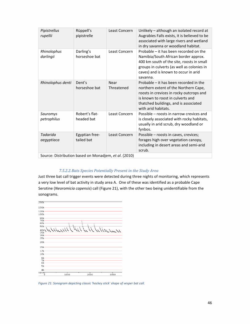
7.5.2.2. BatsSpeciesPotentiallyPresentintheStudyAreaJust three bat call trigger events were detected during three nights of monitoring, which represents
a very low level of bat activity in study area A. One of these was identified as a probable Cape
Serotine (Neoromicia capensis) call (Figure 21), with the other two being unidentifiable from the
sonograms.
Figure 21: Sonogram depicting classic 'hockey stick' shape of vesper bat call.
47
No bat calls were recorded during the manual activity survey on 12 April 2021; however, a single bat
was observed flying very low to the ground, fluttering between shrubs in the southern extent of
study area A, at approximately 1 m height. Based on the observed foraging behaviour, and the fact
that no echolocation calls were picked up by the detector, it is considered highly probable that this
species is Egyptian slit‐faced bat (Nycteris thebaica), which has very quiet calls (the Nycterid family
are known as ‘whispering bats’), and forages in this manner (Monadjem et al., 2010).
7.5.2.3. BatRoostingPotentialA few stunted trees typical of arid conditions occur within study area A; none of these were found to
have any roosting bats at the time of survey, nor were they considered likely to support roosting
bats. The proposed development site is therefore considered to be of limited importance for
roosting bats. Several culverts pass beneath the road adjacent to the eastern extent of this study
area. These were searched for evidence of roosting bats; however, no evidence of bat presence was
observed. A rocky ridge lies approximately 1.5 km to the northwest of the study area, which has
good potential to support crevice‐roosting bats locally. Nearby buildings such as those at the border
post, and Kalahari accommodation centre may also support some roosting bat species.
7.5.2.4. BatactivitypatternsinhabitatswithinthestudyareaInsufficient levels of activity were detected by the passive monitors to make any inferences about
habitat‐linked bat activity patterns within study area A. The arid‐shrub vegetation is likely to be a
seasonally‐important foraging resource for a low number of individual bats in the locality, with
vegetation associated with adjacent drainage lines forming a potential foraging/commuting habitat
for bats traversing the landscape. The main water source for bats in study area A is the dam to the
east of the site; this is likely to dry up during the winter and the importance of the adjoining habitats
in the locality for foraging bats are expected to decrease accordingly.
7.5.2.5. SensitivityofBatHabitattoDevelopmentThe sensitivity of the arid shrubland to development in the context of available bat habitat is
considered moderate, since although it provides foraging habitat for bats, it is availed of by a very
low number of bats, on a seasonal basis. The loss of approximately 10 ha of this habitat to the
proposed development is considered minimal in the context of the vast expanse of similar habitat in
the region, and is not expected to affect foraging or roosting bats detrimentally.
The sensitivity of the ephemeral vegetation to development is considered high. Increased
vegetation density in this habitat feature, plus the occasional presence of water, enhance its support
of flying invertebrate species on which the bat species that occur in this region forage compared to
other habitats in study area A, as well as providing a preferred commuting route for echolocating
bats moving from roosting to foraging areas
7.5.2.6. BatSpeciesofConservationConcernBoth bat species recorded during the survey (Cape serotine and Egyptian slit‐faced bat) are of Least
Concern in terms of conservation status.
Of those considered most likely to be present, one species of conservation importance, Dent’s
horseshoe bat (Rhinolophus denti – Near Threatened) may occur. It has been recorded in the
northern extent of the Northern Cape, roosts in crevices in rocky outcrops as well as thatched
buildings and culverts, and is associated with arid habitats (Monadjem et al., 2010). There is a
48
potential for this species to roost in the rocky outcrop 1.5 km to the northwest of study area A, the
culverts beneath the road adjacent to this study area, and the thatched roofs of nearby buildings
(e.g., the Kalahari information centre); and the species could use the study area for foraging
purposes.
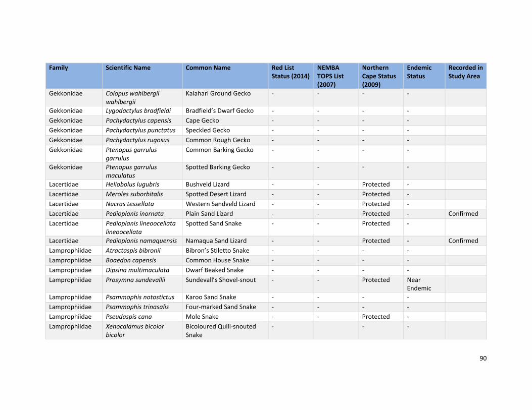
7.5.3. Herpetofauna (Reptiles and Amphibians) 7.5.3.1. ReptilesrecordedandPotentiallyPresentintheStudyArea
Based on the reptile distribution maps presented in Bates et al., (2014) and ReptileMAP records for
the relevant QDS, at least 55 additional reptile species occur in the region and thus potentially occur
in the study areas (Appendix D). Of these, two are specially protected and 13 are listed as protected
in the Northern Cape – presented in Appendix D. None are listed as nationally threatened or
protected.
Three reptile species were recorded in study area A during the field visit. These are the Anchieta’s
Agama (Agama anchietae), Plain Sand Lizard (Pedioplanis inornata) and Namaqua Sand Lizard
(Pedioplanis namaquensis). In terms of the Northern Cape Nature Conservation Act (2009), both the
Plain Sand Lizard and Namaqua Sand Lizard are protected in the province (all species from the Family
Lacertidae are protected).
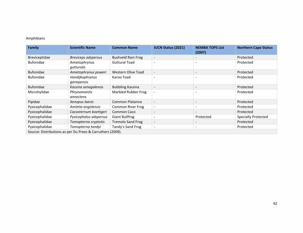
7.5.3.2. AmphibiansPotentiallyPresentintheStudyAreaNo amphibians were recorded in study area A during the field visit. This notwithstanding, based on
published distribution maps, 12 species are known from the broader region (Appendix D). All of
these are either protected, or in the case of the Giant Bullfrog (Pyxicephalus adspersus), specially
protected, according to the Northern Cape Nature Conservation Act (2009).
The Giant Bullfrog is further listed as protected at a national level, in terms of the NEMBA ToPS list
(2007). Giant Bullfrog inhabit seasonal, shallow pans, as well as sandy dams and waterholes (Minter
et al., 2004). These habitats are not present in either study area and therefore it is unlikely that this
species is present.
7.5.4. Invertebrates According to historic distribution maps, two baboon spider species (Family Theraphosidae)
(Dippenaar‐Schoeman, 2014); two rock scorpions (Genus Hadogenes) and three burrowing scorpions
(Genus Opistophthalmus) (Leeming, 2003) have ranges that extend into the far northern Cape, and
thus may occur in the study area – listed in Table 7. At a provincial level, taxa from these groups are
considered either ‘specially protected’ or ‘protected’, according to the Northern Cape Nature
Conservation Act (2009). No evidence indicating the presence of these taxa was observed in study
area A. However, it is possible that some of these taxa are present in both study areas.
Table 7: Baboon spiders, burrowing scorpions and rock scorpions potentially occurring in the study area.
7.6. Key Ecological Processes 7.6.1. Habitat Linkages and Corridors
Outside of the towns of Rietfontein and Groot Mier, the broader landscapes surrounding both study
area A and study area B comprise fairly homogenous natural vegetation, with limited fragmentation
caused by direct habitat modification/transformation. These landscapes are however, fragmented
by livestock‐fences, which may limit the movement of some larger fauna taxa. This notwithstanding,
it is anticipated that smaller and/or more vagile fauna taxa will be able to move across these
barriers.
Several dry geographic low features traverse the landscape surrounding study area A. These
ultimately flow into a large pan located about 14.5 km south‐east of the study area. These features
will provide important movement and dispersal corridors for a fauna, and increase overall habitat
heterogeneity. Aerial imagery suggests that there are no prominent drainage features in the
landscape surrounding study area B.
Overall, despite the presence of livestock fences and both gravel and tarred roads, habitat
connectivity across the broader landscapes in which both study areas are located is considered high.
7.6.2. Processes and Drivers of Change GrazingandOvergrazingBoth study areas are located in a very dry, desert‐like environment. Rainfall is low and infrequent. As
a result, the productivity of herbaceous vegetation (i.e., grasses) is generally low and the region is
unable to support large sedentary herds of wildlife or livestock. This notwithstanding, livestock
(sheep, goats and cattle) are farmed in the region. The abundance of the small grass Enneapogon
desvauxii noted in study area A during the field visit suggests that overgrazing, probably by goats,
has occurred at this site in the past. Overgrazing is a common cause of dryland degradation, leading
to one or several recognised syndromes (sensu. Scholes, 2009), including a change in plant species
composition that manifests as a combination of bush encroachment, a reduction in palatable
grasses, and a reduction in grass productivity (Scholes, 2009).
FireConsidering the overall low grass productivity rendered by low and erratic rainfall, fire is likely to be
very infrequent in the landscapes of both study areas. This was confirmed by Mr Willemse apropos
the study area B landscape. Fire is therefore not considered a frequent disturbance agent and driver
of change in the local ecology. However, it is noted that when fire does occur in the region, it can
have severe negative consequence for the structure and composition of vegetation, which unlike
more mesic savanna and grasslands, is not adapted to fire.
AlienInvasiveSpeciesColonisationPredicated on observations made during the field visit, alien invasive plant species establishment in
dry, upland habitat across the region is not a major concern. However, in low lying depression and
drainage areas where there is elevated soil moisture, and along road sides and other disturbed sites,
alien Prosopis trees are problematic and often establish as the dominant large woody species.
50
If not controlled, it is likely that the continued colonisation and densification of Prosopis trees along
water courses and drainage lines will become highly problematic and potentially compromise
ecological functioning.
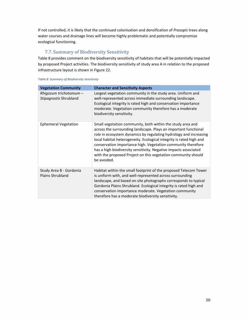
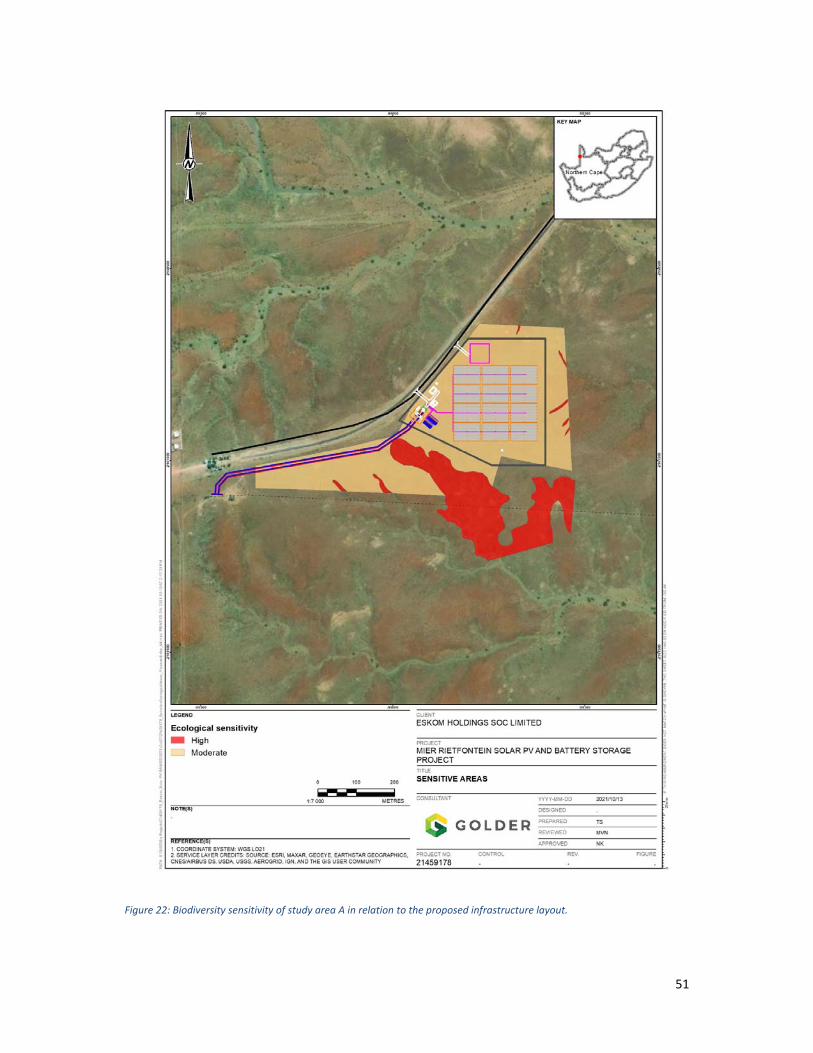
7.7. Summary of Biodiversity Sensitivity Table 8 provides comment on the biodiversity sensitivity of habitats that will be potentially impacted
by proposed Project activities. The biodiversity sensitivity of study area A in relation to the proposed
infrastructure layout is shown in Figure 22.
Table 8: Summary of Biodiversity Sensitivity
Vegetation Community Character and Sensitivity Aspects
Rhigozum trichotomum – Stipagrostis Shrubland
Largest vegetation community in the study area. Uniform and well‐represented across immediate surrounding landscape. Ecological integrity is rated high and conservation importance moderate. Vegetation community therefore has a moderate biodiversity sensitivity.
Ephemeral Vegetation Small vegetation community, both within the study area and across the surrounding landscape. Plays an important functional role in ecosystem dynamics by regulating hydrology and increasing local habitat heterogeneity. Ecological integrity is rated high and conservation importance high. Vegetation community therefore has a high biodiversity sensitivity. Negative impacts associated with the proposed Project on this vegetation community should be avoided.
Study Area B ‐ Gordonia Plains Shrubland
Habitat within the small footprint of the proposed Telecom Tower is uniform with, and well‐represented across surrounding landscape, and based on site photographs corresponds to typical Gordonia Plains Shrubland. Ecological integrity is rated high and conservation importance moderate. Vegetation community therefore has a moderate biodiversity sensitivity.
51
Figure 22: Biodiversity sensitivity of study area A in relation to the proposed infrastructure layout.
52
8. Impact Assessment 8.1. Approach to Impact Assessment
The impact assessment was undertaken using a matrix selection process, the most used
methodology, for determining the significance of potential environmental impacts/risks. This
methodology is based on the minimum requirements as outlined in Appendix 3 of the EIA
Regulations of 2014. The methodology incorporates four aspects for assessing the potential
significance of impacts, namely direction, severity, probability of occurrence, and reversibility, which
are further sub‐divided as follows (Table 9).
Table 9: Impact assessment factors
Direction Severity Probability Reversibility
Positive/ negative
Magnitude Duration Scale/extent Probability of occurrence
Reversible/ irreversible
To determine the significance of each potential impact/risk, the following four ranking scales are
used (Table 10).
Table 10: Impact assessment scoring methodology
Value Description
Magnitude
10 Very high/unknown (of the highest order possible within the bounds of impacts that could occur. In the case of adverse impacts, there is no possible mitigation that could offset the impact, or mitigation is difficult, expensive, time‐consuming or some combination of these. Social, cultural, and economic activities of communities are disrupted to such an extent that these come to a halt).
8 High
6 Moderate (impact is real, but not substantial in relation to other impacts that might take effect within the bounds of those that could occur. In the case of adverse impacts, mitigation is both feasible and easily possible. Social, cultural, and economic activities of communities are changed, but can be continued (albeit in a different form). Modification of the project design or alternative action may be required).
4 Low (impact is of a low order and therefore likely to have little real effect. In the case of adverse impacts, mitigation is either easily achieved or little will be required, or both. Social, cultural, and economic activities of communities can continue unchanged.)
2 Minor
Duration
5 Permanent (Permanent or beyond closure)
4 Long term (more than 15 years)
3 Medium‐term (5 to 15 years)
2 Short‐term (1 to 5 years)
1 Immediate (less than 1 year)
Scale
5 International
4 National
3 Regional
53
2 Local
1 Site only
0 None
Probability
5 Definite/unknown (impact will definitely occur)
4 Highly probable (most likely, 60% to 90% chance)
3 Medium probability (40% to 60% chance)
2 Low probability (5% to 40% chance)
1 Improbable (less than 5% chance)
0 None
5 Definite/unknown (impact will definitely occur)
Significance = (Magnitude + Duration + Scale) x Probability
Table 11: Significance of impact based on point allocation
Points Significance Description
SP>75 High environmental significance
An impact which could influence the decision about whether or not to proceed with the project regardless of any possible mitigation.
SP 30 – 75 Moderate environmental significance
An impact or benefit which is sufficiently important to require management, and which could have an influence on the decision unless it is mitigated.
SP<30 Low environmental significance
Impacts with little real effect and which will not have an influence on or require modification of the project design.
+ Positive impact An impact that is likely to result in positive consequences/effects.
For the methodology outlined above, the following definitions were used:
Direction of an impact may be positive, neutral, or negative with respect to the impact
Magnitude is a measure of the degree of change in a measurement or analysis (e.g., the
severity of an impact on human health, well‐being, and the environment), and is classified as
none/negligible, low, moderate, high, or very high/unknown
Scale/geographic extent refers to the area that could be affected by the impact and is
classified as site, local, regional, national, or international
Duration refers to the length of time over which an environmental impact may occur i.e.,
immediate/transient, short‐term, medium term, long‐term, or permanent
Probability of occurrence is a description of the probability of the impact occurring as
improbable, low probability, medium probability, highly probable or definite
Reversibility of an impact, which may be described as reversible or irreversible
54
8.2. Construction Phase 8.2.1. Impact 1: Habitat Loss and Modification
Habitat loss and modification refers to the removal or degradation of natural habitat. In terrestrial
ecosystems this occurs primarily through vegetation clearing and earth works during construction.
The development of proposed Project infrastructure will require vegetation clearing and earth works
across the entire development footprints of both study areas. This will affect all flora occurring in
each development footprint, as well as all fauna (including bats) that use on‐site habitat and
resources. As the extent of habitat loss/modification at the two study areas varies, each site is
analysed separately:
In study area A, the estimated extent of clearance is about 10 ha. This will result in the potential loss
of both Rhigozum trichotomum – Stipagrostis shrubland and small areas of ephemeral vegetation. In
study area B, only about 0.0025 ha (225 m2) will be cleared.
The impact of habitat loss and modification in study area A associated with the PV Block and BESS
infrastructure prior to mitigation is considered to be of high magnitude, permanently affecting
vegetation in the site. It is considered definite, resulting in an impact of “high” significance. With
mitigation, which includes limiting the disturbance footprint to the absolute minimum required for
construction purposes, the magnitude of the impact can be reduced to moderate, although it will
remain a definite impact at the site scale. This results in an after‐mitigation impact of “moderate”
significance.
Considering the small extent of habitat loss associated with the development of the proposed
Telecom Tower in study area B, prior to mitigation impact magnitude is low. Duration is permanent
and it has a definite probability. The spatial extent will be local. Prior to mitigation, this impact is
rated of “low” significance. After mitigation, habitat loss can be reduced to a minor magnitude,
affecting the site only. Probability will however, remain definite. After mitigation, habitat loss and
modification in study area B is rated an impact of “low” significance.
8.2.2. Impact 2: Establishment and Spread of Alien Invasive Species Disturbances caused by vegetation clearing and earth works during construction can facilitate the
establishment and spread of alien invasive vegetation. Alien plant infestations can spread
exponentially, suppressing or replacing indigenous vegetation. This may result in a breakdown of
ecosystem functioning and a loss of biodiversity. Declared invasive Prosopis trees (NEMBA Category
3) are present in the landscape surrounding the study areas, and it is possible that these species will
colonise areas disturbed by construction activities.
Before mitigation, impact magnitude is high, while duration is long term and it has a high probability.
The spatial extent of alien invasive species spread is local. Prior to mitigation, the establishment and
spread of alien invasive species is rated an impact of “moderate” significance. With the
implementation of active control during the construction phase, this impact can be reduced to a low
magnitude, with a long‐term duration. Spatial extent will be reduced to the site only and the
probability of the impact occurring as predicted would be reduced to low. After mitigation, this
impact is rated to be of “low” significance.
55
8.2.3. Impact 3: Mortality and Disturbance of ground-dwelling Fauna Large and mobile fauna will move off to avoid disturbances caused by construction activities.
However, smaller and less mobile species may be trapped, injured and killed during vegetation
birds, reptiles and amphibians. Other common causes of fauna death or injury include vehicle
collisions along access roads, hunting and snaring by workers, and trapping of fauna in fences,
excavations and trenches.
Before mitigation, impact magnitude is high, while duration is immediate and it has a high
probability. The spatial extent will be local. Prior to mitigation, the mortality and disturbance of
fauna is rated an impact of “moderate” significance. After mitigation, which includes, inter alia,
active supervision by an environmental control officer (ECO) during the construction phase, this
impact can be reduced to a low magnitude, with an immediate duration. The spatial extent will be
maintained at local, but probability will be reduced to low. After mitigation the killing or injuring of
fauna is rated of “low” significance.
8.2.4. Impact 4: Loss/disturbance of roosting bat individuals Site clearance prior to construction could result in direct impacts including mortality and injury of
bat individuals that may occasionally roost in the trees or rocky crevices in the study areas. This is
considered to be an impact of low significance, given the limited importance of the study area for
roosting bats, and the subsequent low magnitude and likelihood of the impact occurring. The risk
can be further minimised by conducting work during the dry season, when bats will not be able to
use the site for foraging, and as such will be even less likely to utilise trees/rocky crevices of the site
as temporary roosts.
8.2.5. Impact 5: Reduction in extent of foraging habitats for bats The loss of natural vegetation within study area A during site clearance will result in a reduction of
approximately 10 ha of available foraging habitat for bats. The predicted reduction in extent of the
vegetation types providing low‐moderate value, seasonal foraging habitat within the study area is
considered of low magnitude in the context of the availability of large areas of similar habitat in the
surrounding landscape; nevertheless, the overall significance of the impact of habitat loss is rated as
moderate. The application of the recommended mitigation measures should ameliorate potential
effects on bat foraging habitat to low significance.
8.2.6. Impact 6: Dust Generation Vegetation clearing, earth works and vehicle activity are likely to result in dust generation, which
may negatively impact both local flora and fauna communities. Before mitigation, impact magnitude
is low, while duration is long‐term and it has a high probability. The spatial extent will be local. Prior
to mitigation, dust generation is rated an impact of “moderate” significance. After mitigation, which
includes, inter alia, active suppression of dust during the construction phase, this impact can be
reduced to a minor magnitude, with a short duration. Spatial extent will be maintained at local, but
probability will be reduced to low. After mitigation, dust generation is rated an impact of “low”
significance.
56
8.2.7. Impact 7: Loss of Flora of Conservation Concern Vegetation clearing and earth works can result in the direct loss of flora species of conservation
concern. Although no threatened (Red List) flora species were observed in the study area A, some
recorded plants (e.g., Commiphora glandulosa) and some species with a ‘possible/probable’
probability of occurrence are ‘protected’ in the Northern Cape or nationally, and it will be necessary
to obtain a clearing permit from the relevant authority for their removal and/or relocation.
Before mitigation, impact magnitude is moderate, while duration is immediate. It has a high
probability of occurrence. The spatial extent of the impact is at the site scale. Prior to mitigation, this
impact is rated of “moderate” significance. This impact can be reduced to a minor magnitude, and
will remain of immediate in duration. Spatial extent will be maintained at the site only, but
probability will be reduced to improbable. After mitigation this impact is rated to be of “low”
significance.
Table 12 presents a summary of the potential impacts/risks during the construction phase.
8.3. Operational Phase 8.3.1. Impact 1: Security Lighting Disturbing Bats and Other Nocturnal Fauna
Predicted operational phase impacts relate to disturbance of typical bat foraging patterns caused by
ongoing activities at the facility (e.g., security lighting at night).
The proposed PV and BESS development is likely to be well‐lit at night for security purposes. This is
expected to cause disturbance to nocturnal faunal species in surrounding areas. Disturbance may
mean that some species are attracted to the lights to prey upon the insects that are attracted to the
lights (particularly some common bat species such as Cape serotine or Egyptian free‐tailed bat);
other more sensitive bat species (such as horseshoe bats) and other nocturnal fauna may be
deterred from well‐lit areas. The magnitude of the effects is expected to be moderate, on a site only
scale. The predicted impact is thus considered to be of moderate significance prior to mitigation.
Once the recommended mitigation measures are applied, the magnitude of effects on nocturnal
fauna can be reduced, reducing the significance of the overall impact to low.
8.3.2. Impact 2: Establishment and Spread of Alien Invasive Species The potential establishment of alien invasive species in, and immediately adjacent to, the study
areas will continue to be an impact of concern during the operational phase. Before mitigation,
impact magnitude is high, while duration is long term and it has a high probability. The spatial extent
of alien invasive species spread is local. Prior to mitigation, the establishment and spread of alien
invasive species is rated an impact of “moderate” significance. With the continued implementation
of an active alien species control programme during the operational phase this impact can be
reduced to a low magnitude, with a long‐term duration. Spatial extent will be reduced to the site
only and probability at low. After mitigation, this impact is rated to be of “low” significance.
8.3.3. Impact 3: Dust Generation During the operational phase, the study areas will be kept free of vegetation through active control.
This may promote dust generation from exposed soil surfaces. Before mitigation, impact magnitude
is low, while duration is long‐term and it has a high probability. The spatial extent will be local. Prior
to mitigation, dust generation is rated an impact of “low” significance. After mitigation, this impact
57
can be reduced to a minor magnitude, with a short duration. Spatial extent will be maintained at
local, but probability will be reduced to low. After mitigation, dust generation is rated an impact of
“low” significance.
Table 12 presents a summary of the potential impacts/risks during the operational phase.
8.4. Decommissioning and Closure Phase 8.4.1. Impact 1: Establishment and Spread of Alien Invasive Species
The potential establishment of alien invasive species in, and immediately adjacent to, the study
areas will continue to be an impact of concern during the decommissioning and closure phase.
Before mitigation, impact magnitude is high, while duration is long term and it has a high probability.
The spatial extent of alien invasive species spread is local. Prior to mitigation, the establishment and
spread of alien invasive species is rated an impact of “moderate” significance. With the continued
implementation of an active alien species control programme for a period after site closure, this
impact can be reduced to a low magnitude, with a short‐term duration. Spatial extent will be
reduced to the site only and probability at low. After mitigation, this impact is rated to be of “low”
significance
8.4.2. Impact 2: Dust Generation The decommissioning and removal of Project infrastructure during the closure phase may result in
dust generation. This may persist until the site revegetates naturally. Before mitigation, impact
magnitude is low, while duration is short‐term and it has a medium probability. The spatial extent
will be local. Prior to mitigation, the dust generation is rated an impact of “moderate” significance.
After mitigation, this impact can be reduced to a minor magnitude, with a short duration. Spatial
extent will be maintained at local, but probability will be reduced to low. After mitigation, dust
generation is rated an impact of “low” significance.
Table 12 presents a summary of the potential impacts/risks during the decommissioning and closure
phases.
58
Table 12: Summary of the potential impacts/risks during the construction, operational, decommissioning and closure phases.
Aspect Potential Impact Impact Assessment Factors Probability Significance without mitigation
Impact Assessment Factors Probability Significance with mitigation
9. Proposed Mitigation Measures The following section presents the proposed impact management actions to avoid, minimise and/or
manage the potential impacts/risks which were assessed Section 8.
As with the assessment of potential impacts/risks, the impact management actions have been
arranged according to the following project phases:
Pre‐construction
Construction
Operational
Closure (including decommissioning)
Post‐closure
For each impact management action, the following information is provided:
Category: The category within which the potential impact/risk occurs
Potential impact/risk: Identified potential impact/risk resulting from the pre‐construction,
construction, operation, and closure of the proposed Project
Description: Description of the possible impact management action
Prescribed standards or practices: Prescribed environmental standards or practices with
which the impact management action must comply. Note that only key standards or
practices have been listed
Mitigation type: The type of mitigation measure. This includes the following:
o Avoidance
o Minimisation
o Rehabilitation or restoration
o Offsetting
Time period: The time period when the impact management actions must be implemented
Responsible persons: The persons who will be responsible for the implementation of the
impact management actions.
Table 13 presents a summary of the proposed impact mitigation actions during the pre‐construction,
construction, operational, and closure (including decommissioning) phases of the project.
63
Table 13: Summary of proposed impact mitigation actions.
Ref No.
Category Potential impact/risk Description Prescribed standards or practices
Mitigation type
Time period Responsible person
1. Pre‐construction phase
1.1 Terrestrial Flora Communities
Habitat loss and modification
At the PV Blocks and BESS site, all proposed Project infrastructure should be positioned outside a 10 m buffer around the ephemeral vegetation community; and
The layout the Telecom Tower site should be positioned to avoid clearing any large, protected trees (e.g., Vachellia erioloba).
N/A Avoidance Prior to construction phase
Project manager
2. Construction phase
2.1 Terrestrial Flora Communities
Habitat loss and modification
Vegetation clearing for the Project,
including the contractor site office and
laydown area, should be restricted to the
proposed Project footprints only, with no
clearing permitted outside of these areas;
The footprints to be cleared should be
clearly demarcated prior to construction to
prevent unnecessary clearing outside of
these areas. No heavy vehicles should travel
beyond the marked works zone;
Preferably, clearance in advance of
construction should be done during the dry
season (April to September); and
N/A Minimisation During construction phase
Project manager
64
Ref No.
Category Potential impact/risk Description Prescribed standards or practices
Mitigation type
Time period Responsible person
Removed topsoil should be stockpiled and
used to rehabilitate all non‐operational
disturbed areas.
Native species planting (where possible with
regard to safety and not hindering firebreak
outs near solar panels) should be used to
aid in the reduction of soil erosion and
additional loss of vegetation beyond the
footprint of cleared areas; and enhance
landscape connectivity around the cleared
solar farm footprint.
2.2 Terrestrial Flora Communities
Establish and spread of alien invasive species
An alien invasive species control programme
must be developed for the Project. It is
recommended that the programme include:
A combined approach using both chemical
and mechanical control methods;
Periodic follow‐up treatments, informed by
regular monitoring; and
A focus on all areas immediately adjacent to
the Project footprints, and in particular,
areas of Ephemeral Vegetation adjacent to
study area A.
N/A Minimisation During construction phase
Project manager
65
Ref No.
Category Potential impact/risk Description Prescribed standards or practices
Mitigation type
Time period Responsible person
2.3 Terrestrial Fauna Communities
Mortality and disturbance of fauna
An ECO should be on‐site during vegetation
clearing to monitor and manage any
wildlife‐human interactions. The ECO should
be trained in inter alia, snake handling,
species identification and identifying
potential bat roosting sites;
A low‐speed limit (recommended 20‐40
km/h) should be enforced on site to reduce
wildlife collisions;
The handling, poisoning and killing of on‐
site fauna by contractors must be strictly
prohibited.
N/A Avoidance / Minimisation
During construction phase
ECO
2.4 Bats Loss/disturbance of bat individuals
Preferably, conduct vegetation clearance during
dry season (April to September).
N/A Minimisation During construction phase
Project manager
2.5 Bats Reduction in extent of foraging habitat for bats
See mitigation measures for Habitat loss and modification
N/A Minimisation During construction phase
Project manager
2.6 Terrestrial Flora and Fauna Communities
Dust generation Active dust suppression using suitable dust suppressant should be implemented during construction, if dust levels become problematic.
N/A Minimisation During construction phase
Project manager
66
Ref No.
Category Potential impact/risk Description Prescribed standards or practices
Mitigation type
Time period Responsible person
2.7 Terrestrial Flora Species
Loss of flora of conservation concern
Surveys of each development footprint should be conducted to identify and record the number of protected flora species that require clearing;
Clearing and/or relocation permits should be obtained from the provincial authority to clear or remove provincially protected flora species occurring on‐site; and
If possible, rescued plants (e.g., small succulents/geophytes) should be relocated to an adjacent area of natural habitat.
N/A Avoidance / Minimisation
Prior to construction phase
Project manager
3. Operational phase
3.1 Bats and other nocturnal mammals
Security lighting disturbing bats and other nocturnal fauna activity
Site lighting options should be managed to minimise effects on flying bats and other nocturnal fauna. Options that should be considered and applied where feasible include:
Use of security lighting that is
movement‐activated rather than
permanently switched on;
Directional shading to prevent excessive
light spillage; and
Use of light bulbs that are not as
attractive to insects (e.g., LED bulbs).
N/A Minimisation During operational phase
Facility manager
67
Ref No.
Category Potential impact/risk Description Prescribed standards or practices
Mitigation type
Time period Responsible person
3.2 Terrestrial Flora Communities
Establish and spread of alien invasive species
Active alien invasive species control should continue throughout the operational phase. Control actions should be informed by the findings of monitoring.
N/A Minimisation During operational phase
Facility manager
3.3 Terrestrial Flora and Fauna Communities
Dust generation Active dust suppression using suitable dust suppressant should be implemented during the operational phase, if required.
N/A Minimisation During operational phase
Facility manager
4. Decommissioning and Closure phase
4.1 Terrestrial Flora Communities
Establish and spread of alien invasive species
Active alien invasive species control should continue during the decommissioning phase and follow up control should be carried out for a five‐ year period following closure.
N/A Minimisation During closure and for a five‐year period after closure
Facility manager
4.2 Terrestrial Flora and Fauna Communities
Dust generation The site should be actively rehabilitated using indigenous and locally sourced grass species. Seeding should be conducted prior to the first summer rains.
N/A Minimisation / Rehabilitation
During closure phase
Facility manager
4.3 Terrestrial
Fauna
Communities
General habitat restoration
Restoration/rehabilitation of the Project footprint should include consideration of compatible measures for habitat enhancement for bat species. Such measures include planting of native species trees and shrubs; and demarcation of rehabilitated areas as conservation areas only.
N/A Minimisation / Rehabilitation
During closure phase
Facility manager
68
10. Proposed Monitoring Actions The following section presents the proposed monitoring actions for monitoring and reporting on the
implementation of the impact mitigation actions presented in the preceding Section 9.
The content of this section is largely based on the monitoring requirements outlined in Appendix 4
of the EIA Regulations, 2014.
For each monitoring action, the following information is provided:
Category: The category within which the potential impact and/or risk occurs
Potential impact/risk: Identified potential impact/risk resulting from the pre‐construction,
construction, operation, and closure of the proposed Project
Method for monitoring : The method for monitoring the implementation of the
recommended mitigation measures
Time period: The time period over which the monitoring actions must be implemented
Frequency of monitoring: The frequency of monitoring the implementation of the
recommended mitigation measures
Mechanism for monitoring compliance: The mechanism for monitoring compliance with the
impact management actions
Responsible persons: The persons who will be responsible for the implementation of the
monitoring actions
As with the impact management actions, the proposed monitoring actions have been arranged
according to the following project phases:
Pre‐construction
Construction
Operational
Closure (including decommissioning)
Post‐closure
Table 14 presents a summary of the proposed monitoring actions during the construction,
Ref. No. Category Method for monitoring Time period Frequency of
monitoring
Mechanism for
monitoring compliance
Responsible
person
1. Construction phase
1.1 Alien invasive
species
Annual on‐site alien invasive species monitoring
should be conducted. Monitoring should focus
on all sites disturbed during the construction
phase; and
Monitoring should assess species type and
density. These data should inform the scope of
ongoing alien invasive species control.
Wet/growing
season
Annual Annual monitoring report Project
manager
2. Operational phase
2.1 Alien invasive
species
Annual on‐site alien invasive species
monitoring should be conducted. Monitoring
should focus on all sites disturbed during the
construction and operational phase
activities, and
Monitoring should assess species type and
density. These data should inform the scope
of ongoing alien invasive species control.
Wet/growing
season
Annual Annual monitoring report Facility
manager
3. Closure phase
3.1 Alien invasive
species
Alien invasive species monitoring should be
conducted on a biannual basis during closure
Wet/growing
season
Biannually
during closure
Annual monitoring report Facility
manager
70
Ref. No. Category Method for monitoring Time period Frequency of
monitoring
Mechanism for
monitoring compliance
Responsible
person
and every five years following closure.
Monitoring should focus on all sites
disturbed by decommissioning and closure
activities.
Monitoring should assess species type and
density. These data should inform the scope
of future alien invasive species control.
& every 5
years after
closure
71
11. Environmental Impact Statement The following section presents a summary of the key findings of the study. Table 15Table 15:
Summary of potential impact impacts/risks. presents a summary of the potential impacts/risks
associated with the proposed Project in the construction, operational, and decommissioning and
closure phases.
Table 15: Summary of potential impact impacts/risks.
Aspect Potential Impact/Risk Significance without Mitigation
Significance with Mitigation
Construction
Vegetation communities
Habitat loss and modification – Study Area A
High Moderate
Vegetation communities
Habitat loss and modification – Study Area B
Low Low
Vegetation communities
Establishment and spread of alien invasive species
Moderate Low
Fauna Mortality and disturbance of fauna Moderate Low
Bats Loss/disturbance of bat individuals Low Low
Bats Reduction in extent of foraging habitat for bats
Moderate Low
Flora and Fauna Dust generation Moderate Low
Protected flora Loss of flora of conservation concern Moderate Low
Operational Phase
Bats, nocturnal fauna
Security lighting disturbing activity Low Low
Vegetation communities
Establishment and spread of alien invasive species
Moderate Low
Flora and Fauna Dust generation Low Low
Decommissioning and Closure
Vegetation communities
Establishment and spread of alien invasive species
Moderate Low
Flora and Fauna Dust generation Moderate Low
11.1. Conditions to be Included in the Environmental Authorisation In addition to the impact mitigation measures presented in Section 9, it is recommended that the
following conditions be included in the EA:
To protect the sensitive ephemeral vegetation from disturbance or degradation, a 10 m buffer
should be demarcated around these areas, within which no project infrastructure or activities
will be permitted; and
Significant residual impacts associated with the permanent loss of approximately 10 ha of
natural habitat (Rhigozum trichotomum – Stipagrostis shrubland) need to be addressed through
the implementation of additional conservation actions. These should include actively controlling
alien invasive flora species (Prosopis species) around the farm dams that are located
downstream of the study area, and implementing anti‐erosion control measures (e.g., rock
packs) at points susceptible to erosion.
72
11.2. Specialist Opinion In accordance with the outcomes of the impact assessment (Section 8) and taking cognisance of the
baseline conditions as presented in Section 7, as well as the impact management measures (Section
9), the proposed Mier Rietfontein Solar PV, Battery Storage and Telecommunications Tower Project,
is not deemed to present significant negative environmental issues or impacts, and it should thus be
authorised.
12. Assumptions, Uncertainties and Gaps in Knowledge The following assumptions and limitations are applicable to the study:
Field work was conducted over a three‐day period in mid‐April and thus represents a ‘snap‐
shot’ survey of on‐site ecology, undertaken during the late‐wet season. It is thus possible
that small short‐lived annuals, geophytes or very cryptic species that are only visible when in
flower may be overlooked during field visit;
The absence or non‐recording of a specific fauna species, at a particular time, does not
necessarily indicate that 1) the species does not occur there; 2) the species does not utilise
resources in that area; or 3) the area does not play an ecological support role in the ecology
of that species;
The delineation of vegetation communities for the vegetation map was conducted using
available Google Earth imagery, and is therefore limited to the spatial and resolution
accuracy of the imagery; and
Field work focused on study area A only. No flora and fauna sampling was conducted in the
small footprint (225 m2) of study area B.
73
13. References Bates, M., Branch, W., Bauer, A., Burger, M., Marais, J., Alexander, G. and De Villiers, M. (eds.) (2014)
Atlas and Red List of the Reptiles of South Africa, Lesotho and Swaziland. Pretoria: Suricata 1, South
African Biodiversity Institute.
Child, M.F., Roxburgh, L., Do Linh San, E., Raimondo, D., Davies‐Mostert, H.T., editors. The 2016 Red
List of Mammals of South Africa, Swaziland and Lesotho. South African National Biodiversity Institute
and Endangered Wildlife Trust, South Africa.
Coates Palgrave, M. (2002). Trees of Southern Africa. Struik Publishers. Cape Town.
Dippenaar‐Schoeman, A. (2014) Field Guide to the Spiders of South Africa. Cape Town: LAPA
Publishers.
Du Preez, L. and Carruthers, V. (2009) A Complete Guide to the Frogs of Southern Africa. Cape Town:
Struik Nature.
Edwards, D. (1983). A broad‐scale structural classification of vegetation for practical purposes.
Bothalia. 14, 3 & 4; 705‐712.
FitzPatrick Institute of African Ornithology (2021). FrogMAP Virtual Museum. Accessed at
http://vmus.adu.org.za/?vm=FrogMAP on 2021‐04‐07
FitzPatrick Institute of African Ornithology (2021). MammalMAP Virtual Museum. Accessed at
http://vmus.adu.org.za/?vm=MammalMAP on 2021‐04‐07
FitzPatrick Institute of African Ornithology (2021). ReptileMAP, Virtual Museum. Accessed at
http://vmus.adu.org.za/?vm=ReptileMAP on 2021‐04‐07
Germishuizen, N., Meyer, N., Steenkamp, Y. and Keith, M. (2006) A Checklist of South African Plants.
Source: Distributions as per Du Preez & Carruthers (2009).
HAWKHEAD CONSULTING
Andrew Zinn – Terrestrial EcologistB.Sc. (Hons.), M.Sc., Pr.Sci.Nat.
HAWKHEAD CONSULTING
Andrew Zinn – Terrestrial EcologistB.Sc. (Hons.), M.Sc., Pr.Sci.Nat.
Profile
Education & Qualifications
University of the WitwatersrandM.Sc. Resource Conservation Biology (2013).
University of KwaZulu-NatalBSc. Hons. Ecology and Conservation Biology (2005).
Published thesis: Inducible defences in Acacia sieberiana in response to giraffe browsing.
University of KwaZulu-NatalBSc. Zoology and Grassland Science (2004).
Bryanston High School, JohannesburgMatric Exemption(2000).
Work Experience
Details
Email: [email protected]: +27 83 361 0373Address: 58 Central Rd, Linden Ext., Johannesburg, 2195South Africa
Date of birth: 14 July 1982Nationality: South African
EcologistGolder Associates Africa, South AfricaJune 2011 – September 2020
Ecologist responsible for the management and implementation of baseline biodiversity studies and ecological impact assessments for development projects in the mining, power generation, transport, land development and industrial development sectors throughout sub-Saharan Africa. Role responsibilities included project management, technical review, biodiversity study design and implementation, flora and fauna surveys, biodiversity baseline and impact assessment reporting, development of biodiversity management plans, rehabilitation plans and alien invasive species control and eradication plans. These studies were conducted to satisfy national environmental regulations and/or international financing requirements, including the International Finance Corporation’s Performance Standard 6.
I am an ecologist with an M.Sc. Degree in Resource Conservation Biology and over 13 years of experience working in biodiversity consulting and ecological research. I am registered with the South African Council of Natural Scientific Professions as a Professional Natural Scientist. I currently work as an independent consulting ecologist, with Hawkhead Consulting. During my career I have worked on projects in remote areas in several African countries including South Africa, Botswana, Democratic Republic of the Congo, Ethiopia, Ghana, Mozambique, Tanzania and Zambia. I have also previously worked in the United Kingdom and the United Arab Emirates.
Independent EcologistHawkhead Consulting, South AfricaSeptember 2020 – Present
Consulting ecologist focusing on terrestrial ecology. I specialise in conducting baseline flora and fauna surveys, ecological impact assessments, and developing mitigation and management programmes for projects and operations in various industry sectors. Core services and responsibilities include, amongst others:
Biodiversity study design and implementation; Biodiversity baseline and impact assessment reporting; Mitigation measure design and application; Vegetation surveys and vegetation community mapping; Fauna surveys for mammals, birds, reptiles and amphibians; Development of biodiversity management plans; Development of rehabilitation and revegetation plans; and Alien invasive species control and eradication plans.
Work Experience (continued)
Research TechnicianYale University, Kruger National Park, South AfricaOctober 2007 – May 2008
Research technician on the Savanna Convergence Experiment (SCE). TheSCE project was a long-term cross-continental study that investigated therole of mega-herbivores in fire-grazing interactions and their influence onvegetation dynamics. Responsible for collecting and analysing vegetationcomposition and productivity data, as well as herbivore distribution data.
Zinn, A.D., D.E., Burkepile and D.I. Thompson (In prep). Impacts of fire and herbivores on tree seedling establishment in a South African savanna.
Burkepile, D.E., C.E. Burns, E. Amendola, G.M. Buis, N. Govender, V. Nelson, C.J. Tambling, D.I. Thompson, A.D. Zinn and M.D. Smith (2013). Habitat selection by large herbivores in a southern African savanna: the relative roles of bottom-up and top-down forces. Ecosphere, 4(11):139.
Knapp, A.K., D.L. Hoover, J.M. Blair, G. Buis, D.E. Burkepile, A. Chamberlain, S.L. Collins, R.W.S Fynn, K.P. Kirkman, M.D. Smith, D. Blake, N. Govender, P. O'Neal, T. Schreck and A. Zinn (2012). A test of two mechanisms proposed to optimize grassland aboveground primary productivity in response to grazing. Journal of Plant Ecology, 5, 357-365.
Zinn, A.D., D. Ward and K. Kirkman (2007). Inducible defences in Acacia sieberiana in response to giraffe browsing. African Journal of Range and Forage Science, 24, 123-129.
Publications
Affiliations
Environmental ConsultantWSP Environment and Energy, South AfricaAugust 2008 – March 2011
Environmental consultant, responsible for a range of environmental projects and services including managing environmental authorisation processes (BAs and EIAs), facilitating stakeholder engagement processes, conducting compliance audits, developing environmental management programmes and conducting specialist ecological studies.
Independent EcologistSubcontracted to KPMG, United Arab EmiratesMarch – April 2011
Subcontracted to KPMG as a subject matter expert (ecology) on theinternal audit of Sir Bani Yas Island’s Conservation Department (UnitedArab Emirates). The audit focused on evaluating the efficacy of the island’svarious conservation practices, including game management, feedprovisioning, carnivore breeding and monitoring, veterinary care andvegetation maintenance.
Member of the South African Wildlife Management Association
Member of the South African Council of Natural Scientific Professions – Professional Natural Scientist (400687/15).
Zinn, A.D. (2007). Exploitation vs. Conservation: A Burgeoning Fifth Column. African Wildlife, 61, 9-11.
Andrew Zinn (2006). Conflict Resolution. Africa Birds and Birding. Vol. 11, No. 5, 12-13.