The impact of NEFODINA convective clouds identification in the rain rate retrieval of H‐SAF 6th IPWG Workshop 15‐19 October 2012, Sao Jose dos Campos, Brazil Francesco Zauli, Daniele Biron, Davide Melfi, Antonio Vocino, Massimiliano Sist Centro Nazionale di Meteorologia e Climatologia Aeronautica
Transcript
The impact of NEFODINA convective clouds identification in the rain rate
retrieval of H‐SAF
6th IPWG Workshop15‐19 October 2012, Sao Jose dos Campos, Brazil
Francesco Zauli, Daniele Biron, Davide Melfi, Antonio Vocino, Massimiliano Sist
Centro Nazionale di Meteorologia e Climatologia Aeronautica
Outline
H‐Saf overview
NEFODINA software
H15 algorithm
Case study: 1st October 2009
Outlooks: RELASE/H50 algorithm
6th IPWG Workshop 2
H‐Saf overview/1
3
The "EUMETSAT Satellite Application Facility on Support to OperationalHydrology and Water Management (H-SAF)" was established by theEUMETSAT Council on 3 July 2005, and kicked-off on 16 September 2005
to provide satellite-derived products from existing and future satellites withsufficient time and space resolution to satisfy the needs of operationalhydrology;
to perform independent validation of the usefulness of the new products forfighting against floods, landslides, avalanches, and evaluating waterresources.
6th IPWG Workshop
H‐Saf overview/2
4
Precipitation from MicrowaveConical scan satellite (SSMI/S)
6th IPWG Workshop
H‐Saf overview/3
5
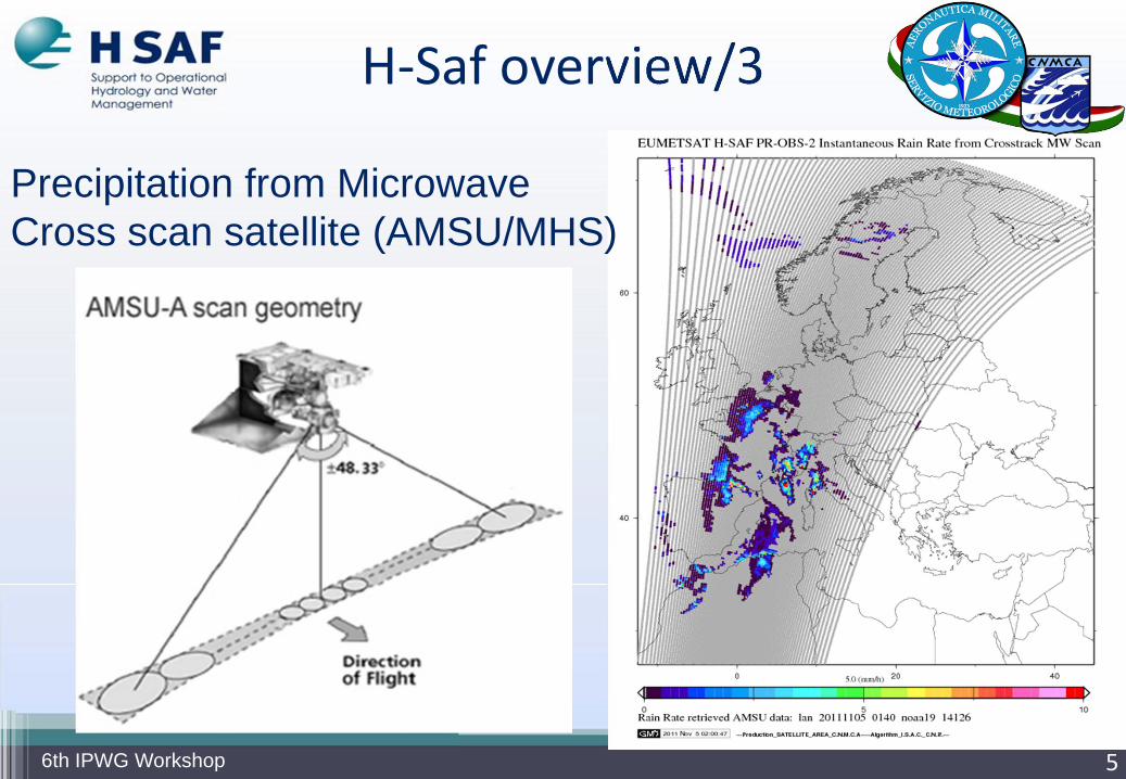
Precipitation from MicrowaveCross scan satellite (AMSU/MHS)
6th IPWG Workshop
Multi-platform algorithm: BLENDING TechniqueThe PR-OBS3 algorithm is basedon a collection of time and spaceoverlapping SEVIRI IR images andLow Earth Orbit (LEO) MWradiometers. As a new MW swathis available, the MW-derived pixelsare paired with the time and spacecoincident geostationary (GEO) TBat 10.8 mm. Coincident data aresubsequently located in ageographical latitude-longitude grid(2.5° x 2.5°), and for each grid boxthe histogram of the IR TBs andthat of the corresponding MW rainrates is built.
6
H‐Saf overview/4
6th IPWG Workshop
Propagation vector matrices areproduced by computing spatiallag correlations over successiveimages of GEO/IR and then usedto propagate the MW-derivedprecipitation estimates in timeand space when updated MWdata are unavailable.
7
Multi-platform algorithm: MORPHING Technique
H‐Saf overview/5
6th IPWG Workshop
H‐Saf overview/6
8
Accumulated Precipitation
6th IPWG Workshop
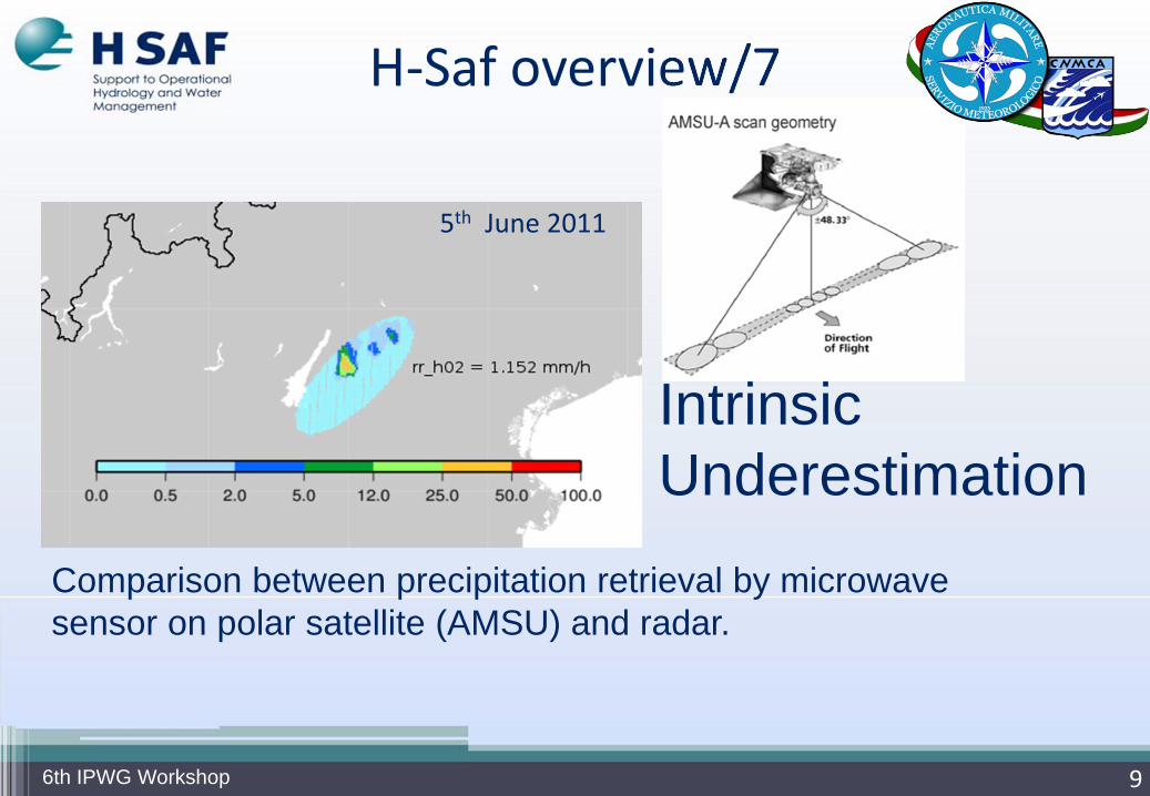
H‐Saf overview/7
9
Comparison between precipitation retrieval by microwave sensor on polar satellite (AMSU) and radar.
5th June 2011
Intrinsic Underestimation
6th IPWG Workshop
NEFODINA software/1
10
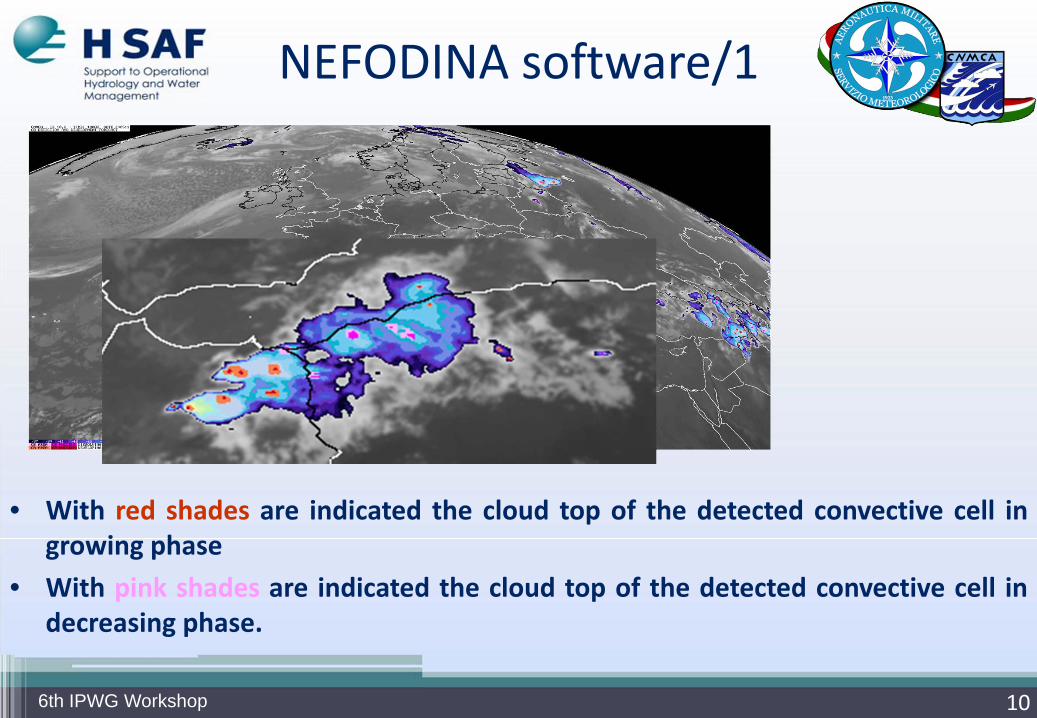
• With red shades are indicated the cloud top of the detected convective cell ingrowing phase
• With pink shades are indicated the cloud top of the detected convective cell indecreasing phase.
6th IPWG Workshop
11
Rain redistribution based on convective cell’s area
NEFODINA software/25th June 2011
6th IPWG Workshop
H15 algorithm
12
HSAF PR-OBS6: BLENDING Technique + NEFODINA
6th IPWG Workshop
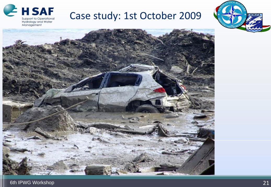
Case study: 1st October 2009
13
The Department of Civil Protection measured 190/200 mm in 5h.
6th IPWG Workshop
Case study: 1st October 2009
14
The Department of Civil Protection measured 190/200 mm in 5h
Heavy rain triggered normal instability along the sides that can turn into disasters and catastrophes when affecting areas deforested and inhabited
The mud flows evolved along the slopehave reached speeds of several tens ofkilometers per hour and large volumes(estimated at between 60.000 and 80.000cubic meters)
6th IPWG Workshop
15
Case study: 1st October 2009
The mud has incorporated thevegetation, dry stone walls andboulders of the substrateacquiring a considerabledestructive power evidenced bythe effects on this area
6th IPWG Workshop
Case study: 1st October 2009
166th IPWG Workshop
Case study: 1st October 2009
176th IPWG Workshop
Case study: 1st October 2009
186th IPWG Workshop
Case study: 1st October 2009
196th IPWG Workshop
Case study: 1st October 2009
206th IPWG Workshop
Case study: 1st October 2009
216th IPWG Workshop
Case study: 1st October 2009
226th IPWG Workshop
Case study: 1st October 2009
23
Accumulated precipitation in the previous 3 hours: 20091001 2100
6th IPWG Workshop
HSAF H02 precipitation retrieval by AMSUmicrowave sensor on polar satellite (cyanelliptical footprint) and radar (with colour scale).
H02 ellipsis as left and occurred lightnings in15 minutes centred in microwave observationtimestamp.
24
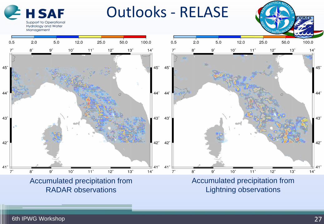
Outlooks
The position of convective precipitation is almost entirely seen by means of lightning rate and locations.
6th IPWG Workshop
Blue: 0.5 ≤ SRI < 12 mm/hGreen: 12 ≤ SRI < 25 mm/hYellow: 25 ≤ SRI < 50 mm/hRed: SRI > 50 mm/h
07 Sept 2005 02:30 UTC
RADAR
Lightning
25
Outlooks ‐ RELASE
6th IPWG Workshop
Rainfall Estimation from Lightning And Seviri data
A rainfall retrieval technique that usesgeostationary satellite Infrared (IR)observations and lightning information retrievedfrom LAMPINET (lightning network of the ItalianAir Force Meteorological Service)
A quantitative relationship for rainfall estimationusing lightning and Seviri data has beendeveloped using a bivariate linear regressionfor the cluster's rain volume :


![MESOSCALE CONVECTIVE SYSTEMS - Semantic Scholar...INTRODUCTION [2] Large ice clouds spread by winds aloft dominate the viewofEarthfromspace.Thesecirriformcloudtopsemanate fromcyclones,bothtropicalandextratropical,andfromlarge](https://static.documents.pub/doc/80x56/601dd49ef7c764209d5317d2/mesoscale-convective-systems-semantic-scholar-introduction-2-large-ice-clouds.jpg)


