Planetary and Space Science 55 (2007) 315–332 The Martian hydrologic system: Multiple recharge centers at large volcanic provinces and the contribution of snowmelt to outflow channel activity Patrick S. Russell a,b, , James W. Head III a a Department of Geological Sciences, Brown University, Providence, RI 02912, USA b Division of Space and Planetary Sciences, Physikalisches Institut, University of Berne, Sidlerstrasse 5, 3012 Berne, Switzerland Accepted 30 March 2006 Available online 7 September 2006 Abstract Global recharge of the martian hydrologic system has traditionally been viewed as occurring through basal melting of the south polar cap. We conclude that regional recharge of a groundwater system at the large volcanic provinces, Elysium and Tharsis, is also very plausible and has several advantages over a south polar recharge source in providing a more direct, efficient supply of water to the outflow channel source regions surrounding these areas. This recharge scenario is proposed to have operated concurrently with and within the context of a global cryosphere–hydrosphere system of the subsurface characteristic of post-Noachian periods. To complement existing groundwater flow modeling studies, we examine geologic evidence and possible mechanisms for accumulation of water at high elevations on the volcanic rises, such as melting snow, infiltration, and increased effective permeability of the subsurface between the recharge zone and outflow source. Evidence for the presence of large Amazonian-aged cold-based piedmont glaciers on the Tharsis Montes has been well documented. Climate modeling predicts snow accumulation on high volcanic rises at obliquities thought to be typical over much of martian history. Thermal gradients causing basal melting of snowpack over 1 km thick could provide several kg m 2 yr 1 of water, charging a volume equivalent to the pore space in a square meter column of subsurface in less than 1.5 10 5 yr. In order to account for estimated outflow channel volumes, the subsurface volume above the elevation of the outflow channels must be charged several times over the area of Tharsis. Complete aquifer recharge can be accomplished in 0.3–2 My through the snowpack melting mechanism at Tharsis and in 5 10 4 years for channel requirements at Elysium. Abundant radial dikes emanating from large martian volcanic rises can crack and/or melt the cryosphere, initiating water outflow and creating anisotropies that can channel subsurface water from a high-elevation groundwater reservoir to outflow sources. In this model, snow accumulation, infiltration of meltwater, and increased effective permeabilities are a consequence of the geologic, thermal, and climatic environment at Elysium and Tharsis, and may have had a genetic influence on the preferential distribution of outflow channels around volcanic rises on Mars. r 2006 Published by Elsevier Ltd. Keywords: Outflow channel; Mars; Hydrological system; Groundwater recharge; Snowmelt 1. Introduction The presence of outflow channels and evidence for their formation through catastrophic release of large volumes of groundwater has intrigued planetary scientists since their initial documentation (see review in Carr, 1996). Models of groundwater systems and cryospheric structures designed to account for the observed outflow channels (e.g., Clifford, 1993) called on a global hydrologic system recharged through basal melting below the south polar cap. Uncertain, however, were the permeabilities required for global recharge, whether the system was indeed globally interconnected, and how recharge and subsurface flow could take place rapidly enough in order to sustain the implied flow rates. In this work we focus specifically on the formation of catastrophic outflow channels sourced in chaos regions or fossae. The conditions that allow for collection, storage, outbreak, subsurface flow, and possibly recharge of source water for these outflow channels are still ARTICLE IN PRESS www.elsevier.com/locate/pss 0032-0633/$ - see front matter r 2006 Published by Elsevier Ltd. doi:10.1016/j.pss.2006.03.010 Corresponding author. E-mail address: [email protected] (P.S. Russell).
Transcript
ARTICLE IN PRESS
0032-0633/$ - se
doi:10.1016/j.ps
�CorrespondE-mail addr
Planetary and Space Science 55 (2007) 315–332
www.elsevier.com/locate/pss
The Martian hydrologic system: Multiple recharge centers atlarge volcanic provinces and the contribution of snowmelt to
outflow channel activity
Patrick S. Russella,b,�, James W. Head IIIa
aDepartment of Geological Sciences, Brown University, Providence, RI 02912, USAbDivision of Space and Planetary Sciences, Physikalisches Institut, University of Berne, Sidlerstrasse 5, 3012 Berne, Switzerland
Accepted 30 March 2006
Available online 7 September 2006
Abstract
Global recharge of the martian hydrologic system has traditionally been viewed as occurring through basal melting of the south polar
cap. We conclude that regional recharge of a groundwater system at the large volcanic provinces, Elysium and Tharsis, is also very
plausible and has several advantages over a south polar recharge source in providing a more direct, efficient supply of water to the
outflow channel source regions surrounding these areas. This recharge scenario is proposed to have operated concurrently with and
within the context of a global cryosphere–hydrosphere system of the subsurface characteristic of post-Noachian periods. To complement
existing groundwater flow modeling studies, we examine geologic evidence and possible mechanisms for accumulation of water at high
elevations on the volcanic rises, such as melting snow, infiltration, and increased effective permeability of the subsurface between the
recharge zone and outflow source. Evidence for the presence of large Amazonian-aged cold-based piedmont glaciers on the Tharsis
Montes has been well documented. Climate modeling predicts snow accumulation on high volcanic rises at obliquities thought to be
typical over much of martian history. Thermal gradients causing basal melting of snowpack over 1 km thick could provide several
kgm�2 yr�1 of water, charging a volume equivalent to the pore space in a square meter column of subsurface in less than 1.5� 105 yr. In
order to account for estimated outflow channel volumes, the subsurface volume above the elevation of the outflow channels must be
charged several times over the area of Tharsis. Complete aquifer recharge can be accomplished in �0.3–2My through the snowpack
melting mechanism at Tharsis and in �5� 104 years for channel requirements at Elysium. Abundant radial dikes emanating from large
martian volcanic rises can crack and/or melt the cryosphere, initiating water outflow and creating anisotropies that can channel
subsurface water from a high-elevation groundwater reservoir to outflow sources. In this model, snow accumulation, infiltration of
meltwater, and increased effective permeabilities are a consequence of the geologic, thermal, and climatic environment at Elysium and
Tharsis, and may have had a genetic influence on the preferential distribution of outflow channels around volcanic rises on Mars.
The presence of outflow channels and evidence for theirformation through catastrophic release of large volumes ofgroundwater has intrigued planetary scientists since theirinitial documentation (see review in Carr, 1996). Models ofgroundwater systems and cryospheric structures designedto account for the observed outflow channels (e.g.,
Clifford, 1993) called on a global hydrologic systemrecharged through basal melting below the south polarcap. Uncertain, however, were the permeabilities requiredfor global recharge, whether the system was indeed globallyinterconnected, and how recharge and subsurface flowcould take place rapidly enough in order to sustain theimplied flow rates. In this work we focus specifically on theformation of catastrophic outflow channels sourced inchaos regions or fossae. The conditions that allow forcollection, storage, outbreak, subsurface flow, and possiblyrecharge of source water for these outflow channels are still
ARTICLE IN PRESSP.S. Russell, J.W. Head III / Planetary and Space Science 55 (2007) 315–332316
puzzling. A major step forward was the Clifford (1993)end-to-end model of the martian hydrological cycle,focusing on subsurface processes. This model allows forconditions under which large volumes of groundwaterconfined beneath a cryosphere would be available to formthe observed outflow channels upon its release. This modelprovides a context in which to test theory with geologicobservations.
In previous studies we have used geologic observationsto constrain and modify the global model on a local andregional basis (e.g., Russell and Head, 2002a, 2003).Investigations of outflow initiation mechanisms, elevationdistributions, and relationships with geologic units andstructures around the Elysium and Tharsis rises at ElysiumFossae (Russell and Head, 2001, 2003), Cerberus Fossae(Head et al., 2003), and Mangala Valles (Head and Wilson,2002; Ghatan et al., 2005) have demonstrated thatobserved outflow activity is consistent with and facilitatedby a two-layer hydrosphere–cryosphere system as de-scribed by Clifford (1993). However, in these analyses adefinitive distinction could not be made between ground-water that ultimately came from south polar cap recharge,as in the global model, and groundwater that wasregionally charged from above, such as at the Elysium rise(Russell and Head, 2003). Several issues concerning theglobal extent and interconnectedness of a martian ground-water system have also been raised (Russell and Head,2002a, b). In this paper we address the hypothesis thatregional recharge of the groundwater system at the Tharsisand Elysium rises, rather than south polar recharge of aglobal groundwater system, is the dominant source ofwater for outflow channels in these areas. The hypothesisof groundwater recharge acting at the large martianvolcanic provinces calls on data concerning climatic,hydrologic, and geologic conditions that can reasonablybe expected to have prevailed on Mars over the majority ofits history (Carr, 1979; Clifford, 1993; Clifford and Parker,2001). The hypothesized regional recharge model isdeveloped within the context of the global cryosphere–hydrosphere system of Clifford (1993).
The mechanism by which water enters the groundwatersystem in Clifford’s (1993) model is by melting at the baseof the south polar cap (e.g., Head and Pratt, 2001), fromwhere it is able to reach all other parts of the planet in ahighly hydraulically interconnected subsurface (Fig. 1).Water is prevented from entering the subsurface watersystem elsewhere by the impermeable frozen zone of theuppermost crust, or cryosphere. This cryosphere is apredictable consequence of estimates of post-Noachiansurface temperature distribution, geothermal heat flow,and subsurface thermal conductivity (Clifford, 1993). Thecryosphere is also able to confine groundwater beneath it aslong as the hydrostatic pressure of the groundwater doesnot exceed the lithostatic pressure of the overlying frozencrust. Comprehensive modeling of the hydrologic char-acteristics of the martian megaregolith suggests that it isunlikely that hydrostatic pressure ever exceeded lithostatic
pressure to potentially cause outflow (Hanna and Phillips,2005a). The process of dike intrusion however, is recog-nized for its ability to disrupt the confining seal of thecryosphere and is considered an important factor ininitiating groundwater outflow on Mars (Head and Wilson,2002; Head et al., 2003; Russell and Head, 2001, 2003;Ghatan et al., 2005; Hanna and Phillips, 2005b; Wilson andHead, 2002a, b). According to Clifford (1993), the hydrau-lic head imparted to an interconnected groundwater systemdue to groundwater mounding beneath the south polar capis sufficient to provide water to an aquifer in the vicinity ofthe outflow channels and planet-wide on a time scale ofX108 years. Clifford and Parker (2001) envision a scenarioin which the hydraulic potentiometric surface resultingfrom sub-polar groundwater mounding is located abovethe elevation of the sources of the outflow channels, thusproviding a source of water and elevational head to supplyflow to the outflow event (Fig. 1d). In this polar rechargemodel, the distance from the recharge zone to the majoroutflow centers at Elysium and Tharsis/Chryse is approxi-mately one-quarter of the planetary circumference, or over5000 km (Fig. 2).Carr (1979) modeled outflow of groundwater from
beneath a cryosphere in the Chryse region, consideringflow rates across the subsurface/surface boundary at anoutflow breakout location and comparing them to esti-mated outflow channel discharge rates. He found thatsubsurface flow is able to account for estimated dischargerates of 105–107m3 s�1 at the surface-subsurface interface atoutflow channel sources, given permeabilities of 10�9m2.Such a permeability is significantly higher than the rangeproposed for nominal megaregolith models of the mar-tian subsurface which are 10�12m2 at 1 km depth to10�15–10�16m2 at 10 km depth (Clifford and Parker,2001; Hanna and Phillips, 2005a). Carr (1979) proposedthat groundwater under Tharsis was lifted to higherelevations as the rise formed, thus providing an elevatedand proximal groundwater source. This model is consistentwith the hydrosphere cryosphere partitioning of the subsur-face in the model of Clifford (1993). However, the Tharsisrise is believed to have been present since early in theNoachian, very early in Mars history (Phillips et al., 2001),and groundwater elevated during formation by uplift atthese early times would have had time to drain away beforethe onset of outflow channel formation in the Hesperian(Scott and Tanaka, 1986). Here we develop the hypothesisthat vertical recharge of the martian groundwater system atlarge volcanic provinces, on a more regional scale andcloser to outflow sources (e.g., Elysium; Russell and Head,2003), is a more viable and more efficient means ofsupplying the large amounts of water required for outflowevents than south polar recharge alone (see also Harrisonand Grimm, 2004, 2005).Recently, Harrison and Grimm (2004, 2005) compared
rates of subsurface flow from the south pole and fromTharsis that would be required to supply water to theChryse outflow channel events using a conservative
ARTICLE IN PRESSP.S. Russell, J.W. Head III / Planetary and Space Science 55 (2007) 315–332 317
permeability structure. Their favored Tharsis rechargemodel supplies a minimum volume of water to carve theoutflow channels (3� 106 km3) within 250My, whereas thesouth polar recharge model requires 810My. The max-imum average subsurface permeability considered was2� 10�13m�2, in which case discharge of a given volumeoccurs �250 times faster for both the Tharsis and southpole models. Harrison and Grimm (2004, 2005) show howthe proximity and elevation difference of Tharsis andChryse translate into hydrologic conditions that are betterable to provide water for the observed outflows, as weexplore in more detail below. In their Tharsis model,instantaneous rates of discharge range from �0.4m3 s�1 at250My after the start of significant discharge (translatingto 100m3 s�1 in their maximum permeability model), to�0.6m3 s�1 at 1000My (Harrison and Grimm, 2005).These values are significantly less than discharge ratesestimated for the outflow channels (Carr, 1979). In ouranalysis, we focus on mechanisms and geologic evidencefor a regional source of water and for mechanisms for itsentry into the groundwater system. We also identifygeologic conditions, such as dike-intruded volcanic con-structs, that might facilitate the transport of this water tooutflow locations. The latter topic is important in assessingCarr’s (1979) requirement of high permeabilities to sustainhigh discharge rates, and in providing the potential forhigher discharge rates within the groundwater transportsystem of Harrison and Grimm (2004). Our investigationof how and where water is likely to enter the subsurface in
Fig. 1. The hydrologic model of Clifford (1993). Each part (a–d) is an
identical composite altimetric profile from the south pole to the north pole
across Tharsis and Chryse (see locations on Fig. 2), illustrating the
elevational and horizontal relationships of the martian topographic
features important in this analysis. Vertical axis is kilometers above and
below mean planetary radius; horizontal axis is in latitude, with north
positive. Key features are labeled in part (a). Vertical exaggeration
�200� . Dark (grey) shading is the basement, within which porosity is
predicted to be negligible. Light blue shading is the cryosphere, the porous
zone of the upper crust in which the temperature is below the freezing
point of water. Tan is the porous zone in which the temperature is above
freezing, but contains no water in its pore space. These three zones
represent the structural and thermal conditions of the upper crust as
envisioned by Clifford (1993) and Clifford and Parker (2001). In (a) there
no groundwater represented in the sub-cryosphere region. (b) It illustrates
how water (dark blue shading) introduced to the groundwater system
would become distributed over geologic time, conforming to an
equipotential surface. Deposition of water on the south polar cap cold
trap leads to melting at the base of the underlying cryosphere. This
meltwater forms a groundwater mound beneath the cap, flowing from
there northward to charge the subsurface in other parts of the planet. (c) It
illustrates the same configuration as above but with a greater total volume
of water in the global subsurface. Note that the confining ability of the
cryosphere can support groundwater under hydraulic pressure beneath the
surface at greater elevation than the adjacent, exterior surface (arrow).
Diagrams based on those of Clifford (1993) and Clifford and Parker
(2001). (d) Same subsurface configuration as (c), illustrating that if the
cryosphere is disrupted in a region where groundwater was previously
confined under the hydraulic pressure head resulting from south polar
basal melting (represented by ho), the water can flow to the surface.
ARTICLE IN PRESS
Fig. 2. Global topography of Mars from MOLA, labeled with features and areas discussed in the text. White lines labeled 1 and 2 are locations of profiles
across Tharsis/Chryse (composite profile) and Elysium, respectively, that are depicted in Figs. 1 and 6. Large white circle at the Tharsis rise is Olympus
Mons. The three smaller white circles are the Tharsis Montes, from southwest to northesast, Arsia, Pavonis, and Ascraeus Montes.
P.S. Russell, J.W. Head III / Planetary and Space Science 55 (2007) 315–332318
the context of a global cryosphere (Clifford, 1993), andhow subsurface transport rates may be increased, comple-ments the hydraulic modeling of Harrison and Grimm(2004).
2. The general conceptual model
Consider a groundwater recharge system analogous tothat proposed for the south pole (Clifford, 1993), butlocated at higher elevations and closer to the outflowchannel breakout locations. The groundwater mound inthis regional case would: (1) represent a large reservoir ofwater concentrated closer to the breakout location; and (2)provide a greater initial hydraulic head compared to that atthe outflow source region, thus steepening the subsurfacehydraulic gradient between the reservoir and breakoutlocation. As the subsurface aquifer immediately surround-ing an outflow breakout location transfers water to theoutflow, the aquifer drains and the hydraulic gradientdriving flow across the subsurface/surface interface at thebreakout location is reduced (Carr, 1979). This situation isanalogous to draw-down of the water level and reductionof the hydraulic gradient resulting from pumping water in adrill hole in a confined aquifer (Fetter, 2001). In order foroutflow to continue at high discharge rates, water must beresupplied to the outflow source through the subsurfacefrom more distant regions. A sufficient rate of resupplydepends on: (1) the availability, or presence, of a subsur-face reservoir of water; (2) the hydraulic gradient drivingwater flow from this reservoir to the breakout interface;and (3) the hydraulic conductivity, governed largely by thepermeability, of the subsurface host rock. Regionalrecharge at high elevations closer to outflow source areaswould be more effective in providing subsurface reservoirsand hydraulic gradients than would polar recharge, asdocumented by Harrison and Grimm (2004). Here we
incorporate the model of regional recharge concept intoour current understanding of the hydrologic cycle on Marsbased on observational evidence and theoretical modeling.This model also addresses the issue of hydraulic con-ductivity by demonstrating that relatively high subsurfacepermeabilities are to be expected in the same geologicenvironments that favor conditions for recharge and whereoutflow channels have occurred.In summary, the basic points of the regional recharge
model are as follows: (1) The groundwater system ischarged regionally at several areas, rather than solely at thesouth pole, providing reservoirs of subsurface water closerto outflow sources; (2) groundwater at these regionalrecharge areas is elevated above the level possible duesolely to polar basal melting; this provides steeperhydraulic gradients near outflow channel locations to drivesubsurface resupply flow more efficiently; (3) water entersthe groundwater system from above as a result of meltingat the base of a snowpack, similar in concept to sub-polarbasal melting; (4) there is a coincidence in the expectedlocations of preferential snow deposition, elevated heatflow, subsurface areas of high effective permeability, andlocations of observed major outflow channels. Ground-water flow modeling results (Harrison and Grimm, 2004)provide the basis for us to incorporate new developmentsinto the regional recharge model. These include: (1) newevidence of low-latitude ice deposits; (2) model resultspredicting low-latitude precipitation at high obliquity; (3)thermal calculations of surface heat flow from subsurfacemagma reservoirs; (4) thermal conditions necessary tocause melting at the base of a snowpack; (5) models of howpropagating dikes disrupt a confining cryosphere andincrease effective permeability near volcanic rises; and (6)spatial and vertical distribution of outflow channels. Weuse these new data and the global model of Clifford (1993)and Clifford and Parker (2001) to establish a more specific
ARTICLE IN PRESSP.S. Russell, J.W. Head III / Planetary and Space Science 55 (2007) 315–332 319
model of regional supply and recharge centers for outflowchannel events.
3. Elevations of outflow channel sources
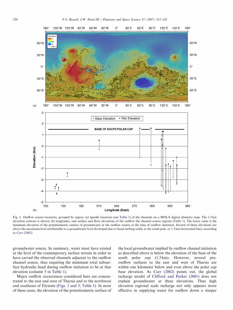
As a fundamental check of the south polar basal meltingrecharge model (Clifford, 1993; Clifford and Parker, 2001),Carr (2002) reviewed the elevations of post-Noachian‘‘water-worn’’ features on Mars. If these features are belowthe maximum possible recharge elevation, i.e. the elevationof the surface beneath the polar cap (1500m), they areconsistent with the model to a first order. According toCarr (2002), the floors of all major outflow sources fit thiscriterion. The main exceptions within the entire class ofwater-worn features include valleys on some volcanoes andfill deposits within Valles Marineris and other chasmata.The elevation of several channels and valleys approach themaximum possible recharge elevation at the base of thesouth polar cap. We retabulate and plot the elevations ofthe major outflow channels (Table 1; Fig. 3) in thefollowing manner. The base elevation of outflow sourcesconsidered by Carr (2002) represents the minimum eleva-tion to which groundwater was supported by subsurface
Table 1
Outflow source locations, grouped by region
Outflow feature (Source–Channel) Approx. lat Approx. lon
East of Tharsis
Iam C–Ares V 2.0 341.7
Hydaspis C–outlet to Ares V 2.6 335.4
Hydroates C–Simud V 3.1 323.2
Hydroates C–Tiu V 2.8 327.3
Hydaspis C–Tiu V 4.5 330.9
Aurorae C–North outlet -5.0 323.0
Aram C–Ares V 3.0 341.2
Shalbatana V 0.5 315.4
Ravi V �1.2 317.4
Ganges Chasma–East outlet �8.2 316.7
Eos Chasma–NE outlet �13.8 318.7
Capri Chasma–East outlet �12.1 316.9
Echus Chasma–Kasei V �0.6 278.9
Juventae Chasma–Maja V �1.4 298
West of Tharsis
fracture–Mangala V �18.3 210.3
Northwest of Elysium
Galaxis F–NW outlet 38.9 138.8
Galaxis F–Hrad V 33.5 141.9
Elysium F–Tinjar/Granicus V 26.4 135.9
Elysium F–Apsus V 30.2 138.1
Southeast of Elysium
Cerberus F–Athabasca V 10.3 156.7
Note: The last column lists the minimum elevation of the potentiometric surfa
This measurement is taken from the channel rim at the upstream-most reach of
measurement is taken where the depression narrows and transitions into the c
The second to last column lists the lowest elevation of the floor of the channel i
of the depression. Several of the surrounding rim elevations cluster around the
basal melting solely at the south pole, or 1.5 km, according to Carr (2002). C
hydraulic head during the outflow event, barring any post-outflow subsidence. We also consider the maximum surfaceelevation at which the water flowed to also have importantimplications for subsurface hydraulic conditions (Fig. 4).If the subsurface hydraulic head allows outflowing water torise only to the currently observable floor elevation ofsource regions, this implies that the channels themselveswere carved by water that never rose above this elevation.In this scenario, the channel formation would have to havestarted underground, near the floor elevation of the sourceregion. Continued erosion presumably would have col-lapsed the overlying ground, which then would have had tohave been removed to form today’s topography. We favorthe more widely accepted mechanism of channel formationby down-cutting over time, based on the morphology of thechannels, as summarized in Carr (1996). If the channel isformed by down-cutting, water must once have beenpresent and flowing at the local pre-outflow surface in theearliest stages of the outflow event, which in turn requiresthe potentiometric surface of the source groundwater tohave been at (or above) this surface elevation. Even thewater level in a crater or chasm lake fed by subsurfacefractures is controlled by the hydrostatic head of the
ce of groundwater at the outflow source at the time of outflow initiation.
the channel. If the channel has its source in a wider enclosed depression, the
hannel. Latitude and longitude coordinates apply to these measurements.
n the area immediately adjacent to the rim measurement, e.g. in the mouth
maximum level attributable to a groundwater level developed solely due to
¼ Chaos, F ¼ Fossae, V ¼ Vallis/es.
ARTICLE IN PRESS
Fig. 3. Outflow source locations, grouped by region: (a) specific locations (see Table 1) of the channels on a MOLA digital altimetry map. The 1.5 km
elevation contour is shown; (b) longitudes, and surface and floor elevations of the outflow the channel source regions (Table 1). The lower value is the
minimum elevation of the potentiometric surface of groundwater at the outflow source at the time of outflow initiation. Several of these elevations are
above the maximum level attributable to a groundwater level developed due to basal melting solely at the south pole, or 1.5 km (horizontal line), according
to Carr (2002).
P.S. Russell, J.W. Head III / Planetary and Space Science 55 (2007) 315–332320
groundwater source. In summary, water must have existedat the level of the contemporary surface terrain in order tohave carved the observed channels adjacent to the outflowchannel source, thus requiring the minimum total subsur-face hydraulic head during outflow initiation to be at thatelevation (column 5 in Table 1).
Major outflow occurrences considered here are concen-trated to the east and west of Tharsis and to the northwestand southeast of Elysium (Figs. 2 and 3; Table 1). In mostof these cases, the elevation of the potentiometric surface of
the local groundwater implied by outflow channel initiationas described above is below the elevation of the base of thesouth polar cap (1.5 km). However, several pre-outflow surfaces to the east and west of Tharsis arewithin one kilometer below and even above the polar capbase elevation. As Carr (2002) points out, the globalrecharge model of Clifford and Parker (2001) does notexplain groundwater at these elevations. Thus highelevation regional scale recharge not only appears moreeffective in supplying water for outflow down a steeper
ARTICLE IN PRESS
surrounding, pre-existing terrain surface
sourcedepression
incipient outflow channel
late stageoutflow channel
sourcedepression
surrounding, pre-existing terrain surface
minimum total hydraulic headimplied by incipient outflow
minimum total hydraulic headimplied by final outflow topography
(a)
(b)
Fig. 4. The effect of outflow elevation measurements on implied subsur-
face hydraulic head. Assuming outflow channels are incised from the top
down, the original surface at the time of incipient outflow must have been
similar to that of the current surrounding terrain. To get water to effuse
from the ground to this elevation, the hydraulic potentiometric surface, or
minimum hydraulic head, must have been at least at this elevation, shown
as a dashed line in part (a). Only in late stages of outflow, when the
channel and source region were excavated, would the minimum hydraulic
head have been at the base elevations of the channels or source regions,
shown as a dashed line in part (b). Taking the former case (a) into
consideration increases estimates of the minimum hydraulic head
necessary at the time of outflow, by an amount approximately equivalent
to the depth of the channel source area below the surrounding surface,
shown by the double-headed arrow in part (b).
P.S. Russell, J.W. Head III / Planetary and Space Science 55 (2007) 315–332 321
hydraulic gradient, but in some instances may also berequired.
4. Sources of groundwater at high elevations
Juvenile water from magmatic intrusions has been citedas one possibility for a water source responsible forforming valley networks on volcanoes (Gulick and Baker,1990), and thus could also be a source of groundwateraccumulation at high elevations. The other general methodfor charging a groundwater system is by addition of surfacewater from above. Early and/or episodic occurrence of rainor snow deposition of water on the surface have beenproposed (1) during a warm early climate with a thickatmosphere (e.g., Craddock and Howard, 2002), (2) due tomajor volcanic eruptions of juvenile water and subsequentsnow precipitation (e.g., Zent, 1999), (3) resulting fromtransient clement climates induced by magmatic disruptionof a groundwater-cryosphere system (e.g., Baker et al.,1991, 2000) or by large impact events (e.g., Segura et al.,2002; Colaprete et al., 2003); and (4) due to the coincidence
of climate-change induced snow accumulation and en-hanced heat flow caused by magmatic intrusions (e.g.,Fassett and Head, 2006).In the absence of an impermeable global subsurface
cryosphere due to relatively high early geothermal heat flux(Clifford and Parker, 2001), a warmer, thicker atmosphereand/or relatively high rates of volcanism may have led tothe potential for addition of water to the subsurface duringthe Noachian (e.g., Craddock and Howard, 2002; Zent,1999; Jakosky and Phillips, 2001). Without the confiningcryosphere, however, water could more easily flow on aglobal scale to areas of low geopotential and would be lesslikely to accumulate in large, regionally elevated zones ofgroundwater (Clifford and Parker, 2001). These conditionsand the dominance of valley networks as opposed tooutflow channels in the Noachian geologic record suggestan Noachian hydrologic system greatly different from thatof the Hesperian or Amazonian (Carr, 1996).By the Hesperian, a substantial cryosphere on the order
of a kilometer thick is expected to have formed due to thedecline in geothermal heat flow (Clifford, 1993; Cliffordand Parker, 2001), prohibiting water due to precipitationfrom accessing the subsurface as is thought to haveoccurred in the Noachian. Average surface temperaturesabove the melting point of water would be required formillions of years to significantly decrease the thickness ofthe cryosphere. Thus, any precipitation due to shortertransient magma- or impact-induced climate events (e.g.,Baker et al., 1991, 2000; Segura et al., 2002; Colapreteet al., 2003) would be blocked from entering the sub-cryosphere groundwater system. In summary, while thetransient climate models may allow for precipitation in theHesperian, and while high elevations may be preferentialsites of precipitation as on Earth, mechanisms are stillrequired for maintaining subsurface temperatures abovefreezing to allow rainwater access to the subsurface and formelting of any precipitation that accumulates in the formof snow.Recently, Carr and Head (2003) presented an updated
model of snowpack basal melting that provides a potentialbasis for charging and recharging a regional groundwatersystem from above. This mechanism of melting isoptimized at times of, or in regions of, high heat flow.Volcanic centers represent not only areas of anomalouslyhigh heat flow, but also relatively high elevations, favoringorographic precipitation and the development of regionallyelevated groundwater tables. What is required are climaticconditions producing significant depths of snowpack andgeothermal conditions capable of melting the base of thesnowpack. We now examine two centers of outflowchannel activity, Elysium and Tharsis, to test for theplausibility of the regional vertical recharge mechanism.
5. Hydrologic considerations at the elysium rise
The Elysium rise (Figs. 2 and 3) consists of a broad,�700 km-wide dome that reaches an elevation of �1400m,
ARTICLE IN PRESSP.S. Russell, J.W. Head III / Planetary and Space Science 55 (2007) 315–332322
from which a steeper volcanic cone, ElysiumMons, extendsup to �14,000m. On the margins of this rise are twovolcanic edifices, Hecates Tholus to the north (�4000melevation) and Albor Tholus to the south (also �4000melevation). The Elysium rise itself is extensively floodedwith Hesperian and Amazonian lavas (Tanaka et al., 1992).Early Amazonian fluvial channels, lava flows, and laharsemanate from fossae on the northwest flank of Elysiumand flow into Utopia basin (Greeley and Guest, 1987).Using MOLA topography and MOC images we haveresolved three main types of units (lavas, sediment-richdebris flows or lahars, and high water-content, late stageflows) and traced them back to their source fossae (Russelland Head, 2003). Those fossae that are the sources of lavasand water-related flows are clustered at elevations below�3100m, with most below �3500m. Fossae occurring atelevations higher than �3100m on the Elysium rise are thesources only of lavas, not groundwater. This elevationaldependence of water sources suggests that their subsurfacesource is also elevationally controlled, as would be the casefor a zone of water-saturated subsurface. We interpret theradial Elysium Fossae to have been initiated by lateralpropagation of dikes that intersected, or nearly intersected,the surface (Russell and Head, 2003). This conclusionis based on fossae morphology, associated features(Chapman, 1994), orientation (Mouginis-Mark, 1985),understanding of the behavior of magmas reaching neutralbuoyancy in a volcanic rise (Wilson and Head, 1994), andthe ability of near surface dikes to form graben (Wilsonand Head, 2002a; Rubin, 1992). In our model ofemplacement history dikes thermally and physicallydisrupted the cryosphere allowing water below the levelof the saturated subsurface to escape to the surface (Fig. 5).
Fig. 5. Perspective and cross-section sketch of the subsurface magmatic
and hydrologic conditions leading to the effusion of water, lava, and
lahars from fossae on the flanks of Elysium Mons. Dotted region is sub-
cryosphere porous zone that is not saturated with groundwater. X marks
the regional water table, or boundary between saturated subsurface
(below) and relatively dry subsurface (above). Dikes propagating laterally
through this subsurface disrupt the cryosphere, allowing water from an
elevated level of saturated ground to flow to the surface. Dikes intersecting
the surface above the zone of subsurface saturation produce only lava
flows. Figure from Russell and Head (2003).
Vertically oriented, planar dikes may have assisted infocusing subsurface flow to these surface fossae (Chapman,1994; Russell and Head, 2003). Above the level of water-saturated ground (marked by the X on Fig. 5), lava flows,and not groundwater, erupted to the surface as a result ofdike intrusion. This elevational configuration suggests asubsurface that is hydrologically stratified. This subsurfaceconfiguration is also locally consistent with the hydro-sphere–cryosphere model of Clifford (1993), but does notnecessarily affirm the south polar source of groundwater ina global system.Another area of evidence supporting a local hydrospher-
e–cryosphere configuration consistent with Clifford’s(1993) model is found on the opposite side of ElysiumMons. On the southeast flanks of the broad volcanic rise,Cerberus Fossae, the sources of Athabasca Valles (Fig. 2),follow the same general northwest–southeast orientation asthe fossae in northwest Elysium, and thus may have formedunder similar conditions of regional stress. These fossae arealso hypothesized to have formed as a result of dikespropagating laterally from Elysium Mons and intersectingthe (near) surface on the southeast flanks of the volcanicrise (Head et al., 2003). Along with lavas, massiveoutpourings of water flowed downslope from the fossaeto interfinger with lava plains (Burr et al., 2002; Head et al.,2003). Calculations by Head et al. (2003) of how muchwater is expected to have been released as a result ofcryosphere–disrupting dike intrusion and tapping of apressurized groundwater system are in general agreementwith flow rates calculated by Burr et al. (2002) based onchannel volumes.Comparison of the elevation and age of the Elysium and
Cerberus Fossae outflows yields insight into whetherrecharge of the groundwater system within the Elysiumrise is required to produce the observed relationships. Theelevation of Cerberus Fossae (��2500m) is higher thanthat of the highest elevation of water-related outflow in thenorthwest Elysium (��3500m). In other words, hydro-logic activity occurred at Cerberus Fossae in the elevationzone where only lavas were effused from Elysium Fossae tothe northwest. In addition, the lava and water flows fromCerberus Fossae are believed to be very young, dating tothe latest Amazonian (Berman and Hartmann, 2002). Thisage is several hundred million to more than a billion yearsyounger than that of the water-related flows in northwestElysium (Tanaka et al., 1992). This inverse relationshipbetween elevation and age suggests that recharge of thegroundwater system within the Elysium rise occurredbetween the two outflow events. Release of groundwaterfrom the Elysium Fossae only occurred up to �3500m inelevation, implying that there was not enough water in theEarly Amazonian to release water at �2500m. Afteroutflow of water from Elysium Fossae, the total volume ofwater stored within Elysium Mons rise would clearly havebeen less than before outflow. Given several hundredmillion to over a billion years without outflow and withoutrecharge between the outflow periods, water within the
ARTICLE IN PRESSP.S. Russell, J.W. Head III / Planetary and Space Science 55 (2007) 315–332 323
Elysium rise should have easily reached elevationalequilibrium, as the expected equilibration time on aplanetary scale is only �100My (Clifford, 1993). Theresulting equilibrium level within the Elysium rise, given norecharge, must therefore be below the equilibrium level ofthe earlier outflows (from Elysium Fossae in the EarlyAmazonian).
In this scenario of no recharge, disruption of thecryosphere several hundred million to over a billion yearslater is expected to release water only below the maximumlevel of previous outflow, i.e. below �3500m. However,outflow at Cerberus occurs at �2500m. Thus, consideringthe subsurface to be hydraulically interconnected on evenconservatively long time scales (�108 years), outflow at therelatively high elevation of �2500m is not expectedwithout recharge. For sufficient water to be present in theElysium rise to account for the Cerberus outflow, rechargeto the groundwater system subsequent to the EarlyAmazonian outflow at the Elysium Fossae is required.
6. A mechanism of regional recharge in a global cryosphere
system
Is recharge of a regional groundwater system from abovea plausible process within a global cryosphere system? Themain problem with charging a sub-cryosphere hydrospherefrom above is that near-surface temperatures are belowfreezing, preventing infiltration and transport of waterthrough the cryosphere. In this manner the cryosphereeffectively acts as a seal inhibiting the passage of waterfrom above as well as from below (Clifford, 1993).
Carr and Head (2003) have shown that accumulation ofsnow or ice deposits could result in production of liquidwater by melting at their base without the requirement ofrainfall or a warmer climate, which are problematic frommany theoretical standpoints (see summary by Haberle,1998). The main factors leading to such basal melting arethe insulating effect of the snowpack from the coldatmosphere and the geothermal heat flow from below.Carr and Head (2003) consider the effect of porosity onsnowpack thermal conductivity and conclude that theincrease of conductivity with depth within the snowpackmay be expressed as
logðKÞ ¼ 0:4þ 2:9 logðrÞ, (1)
where K is thermal conductivity of the snowpack (inWm�1K�1) and r is snowpack density (in g cm�3—notethat the text and Fig. 1 of Carr and Head (2003) imply r isin kgm�3, however their Eq. (1) is written for r in g cm�3).The relationship in Eq. (1) is considered a good approx-imation for Mars as it runs along the lower bounds ofterrestrial estimates of the conductivity–density relation-ships which are those terrestrial estimates done at thecoldest temperatures (Carr and Head, Fig. 1, 2003). Therelationship between density and depth is
r ¼ ri � ðri � rsÞ exp½�CðgMars=gEarthÞz�, (2)
where ri is the density of ice (917 kgm�3), rs is the densityof the snowpack surface (300 kgm�3), C is a constant(normally between 0.02 and 0.03 on Earth; we use 0.025),g is gravity, and z is depth within the snowpack (Carr andHead, 2003).Given planetary average surface temperatures of 210
(current) or 230K (early greenhouse) and a geothermalheat flux of 0.1–0.15Wm�2, melting could occur at thebase of a snowpack on Mars fifty to a few hundred metersthick (Carr and Head, 2003). For purposes of a con-servative argument, we assume that planetary surfacetemperatures attained values similar to those of todaysoon after the end of the heavy bombardment. Pre-MGSmodels predict a heat flow in the Late Noachian of�0.15Wm�2, a value which declines through the Hesper-ian but remains around 0.1Wm�2 for this latter period (seereview in Schubert et al., 1992). More current work,however, suggests that heat flow decreased much morequickly and was significantly less over the planet’s history.Recent modeling indicates heat flow had already decreasedto 0.05–0.08Wm�2 by the Middle Noachian, from whichpoint it decreased gradually to current values of0.02–0.03Wm�2 (see review in Spohn et al., 2001). Thislater study is supported by analysis of gravity andtopography data suggesting that heat flow was 0.04 to40.06Wm�2 in the Noachian and p0.03Wm�2 in theHesperian and later (Zuber et al., 2000; McGovern et al.,2002). Thus, nominal heat flow for the Late Noachian andlater was likely well below the values used in the Carr andHead (2003) modeling study (Solomon et al., 2005).However, heat flow could be higher in local settings suchas volcanoes. Fassett and Head (2004, 2006) model thediffusion of heat from a magma chamber beneath thecenter of a volcano under current martian conditions anddemonstrate that local heat flow to the surface, especiallytowards the center of the volcano, can be increasedsignificantly to at least 0.1Wm�2 (in the case that theymodeled) by this mechanism. Thus, conduction from alocal heat source as modeled by Fassett and Head (2004,2006) could initiate basal melting beneath a few hundredmeters of snow or ice in post-heavy bombardmentconditions as calculated by Carr and Head (2003).The presence of a snowpack in a region of elevated heat
flow as presented above essentially raises the meltingisotherm up to the surface, to the base of the snowpack. Inthis configuration, if basal melting of the snowpack isoccurring as predicted, the underlying upper crust will nolonger be below freezing. In a basal melting situation, anyliquid water produced is free to infiltrate the ground andpercolate down to the local groundwater table. Thishypothesized scenario is depicted at a volcanic riserepresenting Tharsis and the superposed montes in Fig. 6.As is the case beneath the south pole, a groundwatermound would build beneath this region of recharge(Fig. 6a), the height of which would depend on the rateof recharge and the permeability of the surrounding rock.Because of the high elevation of the recharge zone, this
ARTICLE IN PRESS
-15
-10
-5
0
5
10
15
-90 -70 -50 -30 -10 10 30 50 70 90
(a)
-15
-10
-5
0
5
10
15
-90 -70 -50 -30 -10 10 30 50 70 90
(b)
-15
-10
-5
0
5
10
15
-90 -70 -50 -30 -10 10 30 50 70 90
(c)
ho
Elysium
Tharsis
Fig. 6. Regional recharge of the groundwater system at the Tharsis and
Elysium rises rather than at the south pole (compare to Fig. 1). Vertical
axis is kilometers above and below mean planetary radius; horizontal axis
is in latitude, with north positive. The source of water is snowpack that
preferentially accumulates at high martian volcanic rises. Elevated heat
flow due to magmatic activity elevates the melting isotherm, causing the
base of the cryosphere to rise to the ground surface. This both eliminates
the impermeable obstacle the cryosphere represents to infiltration and
causes melting at the base of the snowpack. (a) as a result of basal melting
and infiltration, a groundwater mound now builds Beneath Tharsis. (b)
Provides a closer reservoir and higher hydraulic pressure head (ho) for flow
to resupply water at the outflow breakout location. (c) Same model
represented in (b) for the Elysium region.
0
2
4
6
8
10
12
14
16
18
20
0 200 400 600 800 1000 1200 1400 1600 1800 2000
Qo = 0.10
Qo = 0.15
Equilibrium Snowpack/Ice Thickness (m)
Rat
e o
f M
elti
ng
(kg
-1 /
yr /
m-2
)
Fig. 7. The relationship between the equilibrium thickness of an overlying
snowpack and the rate of melting at its base, at two different surface heat
flows (0.15 and 0.1Wm�2). A surface heat flow of 0.1Wm�2 is easily
achieved in post-Noachian times above a cooling magma chamber (e.g.,
Fassett and Head, 2004). Melting rate is calculated using an integrated
porosity-dependent thermal conductivity within the snowpack and the
assumption that the snowpack remains at a relatively constant thickness
for the majority of its duration (Carr and Head, 2003). No melting occurs
at the base of the snowpack for thicknesses below those indicated by the
x-intercept of each curve.
P.S. Russell, J.W. Head III / Planetary and Space Science 55 (2007) 315–332324
groundwater mound would be capable of providing agreater hydraulic head relative to the outflow location(Fig. 6b) than would a sub-south polar groundwater mound
(Fig. 1d). In addition, a nearby vertical recharge zone suchas this could provide a large reservoir of groundwater at agiven elevation in the region of outflow sources withoutnecessitating the filling of all the planet’s pore space to thatelevation, as required by a system charged solely by basalmelting at the south pole, a quarter-planet’s distance away(Fig. 6b). Fig. 6c depicts an analogous scenario of regionalvertical recharge and outflow at Elysium.We calculate a range of possible recharge-rate estimates
based on thermal conductivities suggested by Carr andHead (2003) (Eqs. (1) and (2)) and a geothermal heat flowtypical of a volcanic setting as suggested by Fassett andHead (2004, 2006) (0.1Wm�2). We consider a steady-statesnowpack of thickness z with an average surface tempera-ture, Tsurf, of 210K and a basal temperature, Tmelt, of273K, the most conservative condition for melting. At theinterface of the ground surface and the snowpack base, theamount of heat flow out of the ground (Qo) is equal to theamount of heat flow into the base of the snowpack (Q1)plus the amount of latent heat consumed while melting athin layer of snow/ice at the interface:
Q0 ¼ Q1 þ RL, (3)
where R is the rate at which water is produced by meltingat the base of a snowpack and L is the latent heat of fusionof ice (3.3� 105 J kg�1). Q1 can be found for a givensnowpack thickness from the solution of the one-dimen-sional heat flow equation using the parameters above.The rate at which water is melted at the base of asnowpack is potentially made available for groundwater
ARTICLE IN PRESS
0
20000
40000
60000
80000
100000
120000
140000
160000
180000
200000
0 200 400 600 800 1000 1200 1400 1600 1800 2000
Equilibrium Snowpack Thickness (m)
Tim
e to
ch
ang
e p
ore
sp
ace
volu
me
of
colu
mn
of
sub
surf
ace
(kyr
)
Qo = 0.15
Qo = 0.10
Fig. 8. Using the melting rates in Fig. 7, equilibrium snowpack thickness
is plotted against the time it would take to fill a column of subsurface
equivalent to the integrated pore space below the recharge area between
the base of the cryosphere and the top of the basement, or �200m. At
snowpack thicknesses at which melting is initiated (see Fig. 7) the time to
fill any amount of pore space is infinite, and not shown on this graph.
P.S. Russell, J.W. Head III / Planetary and Space Science 55 (2007) 315–332 325
recharge is then:
R ¼ Qo �
R z
0 KðTmelt � T surf Þ
z
� �1
L, (4)
where the net effective thermal conductivity for a verticalcolumn of the snowpack is obtained through integration ofconductivity from the surface to the base of the snowpack.Rates of potential recharge to the subsurface are shown asa function of equilibrium snowpack thickness in Fig. 7.Under conditions outlined above including a local heatflow of 0.1Wm�2, the equilibrium snowpack thicknessmust be at least �1000m for melting to occur beneath it.1 kg yr�1m�2 (equivalent to a 1mm column under 1m2 ofsurface in 1 year) of water is produced under 1100m ofsnowpack, and �8 kg yr�1m�2 is produced under 2000m.If the geothermal heat flow (Qo) is as high as 0.15Wm�2,melting first occurs under a snowpack �550m thick andreaches rates of �9 kg yr�1m�2 at 1 km thick and�17 kg yr�1m�2 at 2 km thick. Melting rates are higherbeneath thicker snowpacks because increasing the thick-ness of the snowpack decreases the heat flow across it, Q1,making more energy available at the snowpack-groundinterface (Eqs. (3) and (4)). The increase in thermalconductivity with density (Eq. (1)) causes the effectivethermal conductivity of a column of snowpack to approachthe relatively high value of ice with increasing depth. Thisconductivity trend tends to increase Q1 in thickersnowpacks, suppressing melting. Because conductivityexponentially approaches a constant maximum value,however, suppression of melting in thicker snowpacks isoverwhelmed by the increased melting that occurs withdepth.
The rate of infiltration and downwards movement ofwater depends on the properties of the surface andsubsurface and will determine the portion of melted waterthat will reach the groundwater system. Typical infiltrationrates of soils on Earth are measured on the order ofmmh�1 (Fetter, 2001). In comparison, the rates of meltproduction obtained above (Fig. 7) are on the order of10�3–10�4mmh�1. Modeling of the water table withinterrestrial volcanic edifices finds that a decay of perme-ability with depth from 10�13 to 10�17m2 can accommo-date infiltration rates of 1myr�1 , or 0.1mmhr�1, withinthe upper few kilometers of the subsurface of the Cascaderange in Oregon, USA (Hurwitz et al., 2003). Thus,meltwater produced by basal melting on a martian volcanowould be easily accommodated by the surface infiltrationcapacity and the permeability of the near surface. Theeffective rate of recharge to the subsurface is thereforeconsidered equivalent to the melting rate. If the subsurfacepore space were to fill completely, infiltration would thenbe limited by the flow of groundwater through and out ofthe system (see, for example, Harrison and Grimm, 2004).
The time scale required to recharge the local ground-water system for estimation purposes is the time it takes formelting at the base of an equilibrium-thickness snowpack
(as per Eq. (4)) to fill the pore space of a column of thesubsurface between the top of the basement and the base ofthe cryosphere. This estimate will be a minimum timebecause it assumes continuous melting and because watermay flow through the subsurface away from the region ofrecharge. The available pore space is equivalent to a�200m column of water, assuming a 2.5 km-thick cryo-sphere at low latitudes, a surface porosity of 20%, anexponential decay in porosity with depth, and a self-compaction depth (where porosity is o1% and thereforenegligible) of �8.5 km below the surface (followingClifford, 1993). The resulting time to recharge this columnequivalent is less than 1.5� 105 years for snowpacks over1100m thick (Fig. 8).Harrison and Grimm (2004) and Fassett and Head
(2004, 2006) also suggest that advection of heat by anygroundwater present would increase heat flow to thesurface (including slightly increased heat flow further fromthe summit). Gulick (1998) demonstrates that water maycirculate to the surface of a volcano in a purelyhydrothermal-convection model. Recent three-dimensionalhydrological modeling of water convection in the subsur-face below a cryosphere suggests that the cryosphere maybe thinned from its nominal thickness of several kilometersto a minimum of �300m depending on model inputparameters (Travis et al., 2003). Any such increase in heatflow (Fassett and Head, 2004, 2006), hydrothermal activityat the surface (Gulick, 1998), or thinning of the cryosphere(Travis et al., 2003) would only facilitate basal meltingbeyond the predictions of the nominal model we havepresented based on the work of Carr and Head (2003) andFassett and Head (2004, 2006). In conclusion, basalmelting of an accumulated snowpack on regions withanomalously high heat flux, such as volcanoes, is a
ARTICLE IN PRESSP.S. Russell, J.W. Head III / Planetary and Space Science 55 (2007) 315–332326
plausible mechanism for providing a source of water forrecharging the regional groundwater supply and creatingan elevated mound of groundwater.
7. Evidence for recharge at volcanic rises
Is there geologic evidence and support in modeling forthe former presence of liquid or solid surface water at themajor volcanic provinces, Elysium and Tharsis? It is bothin these regions that basal melting as described abovewould have been most likely to occur, and around theserises that a significant fraction of martian outflow channelshave their source. The Tharsis rise contains four largevolcanic edifices over 14,000m (Olympus, Arsia, Pavonis,Ascreaus Montes) and is central to major instances ofoutflow activity (Figs. 2 and 3). The Chryse outflows, to theeast of Tharsis, are sourced in chaotic terrain anddepressions near the eastern end of Valles Marineris (Carr,1996). Mangala Vallis, to the west of Tharsis, emanatesfrom a graben extending from the southeast of Tharsis(Tanaka and Chapman, 1990; Ghatan et al., 2005).
The gently sloping volcanoes Hecates Tholus, on thenorthern periphery of the Elysium rise, and CerauniusTholus, on the northern side of the Tharsis rise, are coveredwith a radial system of valley networks documented indetail by Gulick and Baker (1990). The pattern andmorphology of the valley systems strongly suggest thatthe upper, central reaches of the volcanoes were a source ofsurface and/or near-surface water. The valleys are inter-preted to have been formed by both overland flow andseepage in a highly porous medium, resulting fromhydrothermal convection (Gulick and Baker, 1990) ormelting beneath a snowpack (Fassett and Head, 2004,2006). The hydrothermal interpretation is dependent on thepresence of groundwater in the upper elevations of thevolcanoes and is consistent with the existence of a regionalgroundwater system. In the basal melting scenario aportion of meltwater would have infiltrated the subsurface,providing water to the groundwater system. The latterprocess is not only a plausible mechanism for charging theregional groundwater system, but is also arguably the mostdirect method for providing the water at high elevationsnecessary to a hydrothermal system. The formation ofvalleys by overland flow of meltwater requires productionof basal meltwater in excess of the infiltration rate. Givensurface infiltration rates and near-surface permeability asdiscussed above (Hurwitz et al., 2003), excess meltwaterproduction would require substantially higher heat flow,consistent with the effect hydrothermal advection of heatwould have on the base of a snowpack. In summary, thedevelopment of a snowpack and the onset of basal meltingby elevated geothermal heat flow is consistent with thesubsequent initiation of hydrothermal activity. In turn,hydrothermal activity could have contributed to valleyformation either directly (Gulick and Baker, 1990) or byincreasing meltwater production rates above the infiltration
rate at the base of the overlying snowpack (e.g., Fassettand Head, 2004, 2006).Elysium Mons and the four large Tharsis volcanoes do
not display extensive valley systems. The surfaces ofHecates and Ceraunius Tholi are dated to the Late andEarly Hesperian, respectively (Gulick and Baker, 1990).Effusive lava flow activity continued to cover the flanks ofthe much larger Elysium Mons until at least the EarlyAmazonian (Tanaka et al., 1992). At Tharsis, the majorityof surfaces of Olympus Mons are Late Amazonian(Hartmann and Neukum, 2001), most of Arsia Mons isMid Amazonian (Hartmann and Neukum, 2001), and thenortheast and southwest flank eruptions of the TharsisMontes, as well as the vast surrounding lava plains, areMid to Late Amazonian (Scott and Tanaka, 1986). Ifvalley networks formed from excess meltwater at the baseof a snowpack or from hydrothermal circulation withinhigh-elevation groundwater on the Tharsis or ElysiumMontes, they would have since been buried by these laterlava flows.The Tholi valley networks provide good evidence for
snowpack accumulation, subsequent hydrothermal activ-ity, and groundwater charging. In a self-consistent modelof groundwater charging, outflow events must occur duringor after the period of charging activity. The outflows fromthe northwest Elysium Fossae are Early Amazonian, theChryse outflows around Valles Marineris off the east edgeof Tharsis are Late Hesperian, and Mangala Vallis off tothe southwest of Tharsis is Late Hesperian (Scott andTanaka, 1986; Greeley and Guest, 1987). Thus, the ages ofpostulated snowpack activity on the Tholi (Hesperian) andactive outflow (Late Hesperian, Early Amazonian) arebroadly consistent. Outflow at Cerberus is much youngeras previously discussed (Burr et al., 2002; Berman andHartmann, 2002).Lack of evidence for liquid water run-off on the large
Montes of the Elysium and Tharsis rises does not meanthat meltwater production, such as that observed at theneighboring Tholi, has not occurred. Aqueous channelsand valleys could have been obliterated by continuederuptive activity of the larger Montes later into martianhistory or meltwater production rates may simply not havebeen great enough to exceed infiltration rates and producevalley-forming run-off. However, evidence for the pastpresence of liquid or solid water on the large volcanicprovinces beyond that at the relatively small Tholi wouldbe necessary to establish the case that the Elysium andTharsis rises were significant centers of snow or wateraccumulation, with the resulting potential of verticallyrecharging the groundwater system. Here we synthesizeevidence from the literature that significant snow or icedeposits have accumulated at all four of the major Tharsisvolcanoes in the past, making them plausible candidatesfor groundwater recharge centers through the process ofbasal melting and infiltration.A series of geomorphic units on the northwest flanks of
the four large Tharsis Montes have been interpreted as
ARTICLE IN PRESSP.S. Russell, J.W. Head III / Planetary and Space Science 55 (2007) 315–332 327
deposits left by cold-based glaciers based on morphologyand comparison to terrestrial wet-based glaciers (Lucchitta,1981) and based on high-resolution MOLA topographyand comparison to Antarctic cold-based ice sheets (Headand Marchant, 2003; Shean et al., 2005; Milkovich andHead, 2003; Milkovich et al., 2006; Parsons and Head,2004). A typical sequence of facies, from distal to proximaldeposits, as summarized from this latter group of workersis as follows: a ridged facies consisting of hundreds ofconcentric thin ridges, interpreted as drop moraines by aretreating cold based glacier; a knobby facies consisting ofsmall, sometimes elongated knobs, interpreted to besublimation till resulting from down-wasting of an icedeposit with a significant sediment component; and asmooth facies of gently sloping terrain and lobate featuresthat are interpreted as debris-covered alpine and piedmontglaciers. These deposits on all of the three major TharsisMontes are similarly interpreted as resulting from theactivity of cold-based, debris-covered piedmont glaciers, asare the piedmont lobes seen along the base of thenorthwestern Olympus Mons scarp (e.g., Head et al.,2005; Milkovich et al., 2006).
Cold-based glaciers are frozen to their bed, meaning thatunderlying topography may remain relatively unaltered intheir presence, and that flow occurs within the overlying ice(Benn and Evans, 1998). By definition, there is no basalmelting associated with such features. However, thedemonstration that significant ice deposits collected aroundthe Tharsis Montes in the Late Amazonian lends supportto the plausibility that they could also have formed hereearlier and that they may have previously undergone basalmelting to supply water to the subsurface. In at least oneinstance, evidence that a lava flow banked up against aformerly existing ice deposit, indicates that ice depositswere not restricted solely to times after lava flow activity,and potentially heightened heat flow, had ceased (Sheanet al., 2005). The latest manifestations of these ice depositswere significant in volume, covering areas of �180,000 and75,000 km2 at Arsia Mons and Pavonis Mons, respectively,and an elevation range of �5 km on the slopes of bothvolcanoes (Head and Marchant, 2003; Shean et al., 2005).Evidence from the lava flows interpreted to have beenbanked up against ice deposits yields a minimum ice sheetthickness of �250m (Shean et al., 2005). Given the areaand elevation range covered by these ice sheets, profilemodeling of the ice sheet suggests that thicknesses on theorder of 2 km are reasonable (Shean et al., 2004, 2005;Fastook et al., 2005).
The morphological and topographic evidence for sig-nificant ice deposits on the Tharsis rise is supported bymodeling studies which suggest that if massive ice is goingto form at martian low latitudes, it would likely form onthe Tharsis and Elysium rises (Mischna et al., 2003, 2004;Haberle et al., 2004; Forget et al., 2006). Supportingprevious predictions (Jakosky and Carr, 1985), the latestglobal circulation models predict that at obliquities higherthan �451, which is estimated to be the most probable
obliquity of Mars throughout its history (Laskar et al.,2004), ice should accumulate at high elevations, especiallyat the Tharsis Montes, and persist year-round (Mischnaet al., 2003, 2004; Haberle et al., 2004; Forget et al., 2006).In addition, planetary scale images of Mars from MOCand laser reflections from MOLA show that areas ofregional cloud cover in today’s climate include the Tharsisrise (Neumann et al., 2003). Three strong lines of geologic,climate modeling, and atmospheric evidence, as well asradial valley networks on Tholi, provide a plausible casethat snow and/or ice is likely to have been present on largevolcanoes at times during the martian past.Ice deposits on the flanks of Tharsis Montes appear
geologically recent, having been emplaced on top of andbelow Mid to Late Amazonian lava flows clearly visible intopography data (e.g., Head and Marchant, 2003; Sheanet al., 2006). Modeling suggests that deposition occurred atperiods of higher obliquity than that of today (Mischnaet al., 2003, 2004; Haberle et al., 2004; Forget et al., 2006).The variation of orbital parameters necessary to shift theclimate from that of today to one in which low latitudesnow or ice deposits would be common are likely to betypical of much of the history of Mars (Laskar et al., 2004).Between 10 and 5Mya, obliquity ranged from 251 to 451,significantly higher than the range of 15–351 since 5Mya(Laskar et al., 2004). It is in periods of high obliquity thatthe Tharsis ice deposits are likely to have formed. Prior to20Mya, calculations of the nature of Mars’ orbit becomechaotic and thus impossible to reasonably predict (Laskaret al., 2004). However, statistical analyses predict that atany point in the last 4Gy of martian history, the mostprobable obliquity at that time was �411, with a �90%probability that obliquities over 601 were reached (Laskaret al., 2004). Thus, the orbital conditions resulting in theclimate that produced the observed latest Amazonianevidence for surface ice on Tharsis were likely to be theorbital conditions most prevalent over extended periods ofthe martian past. Orbital influences on climate would besuperposed on monotonic and/or endogenic influences onclimate such as atmospheric loss and decline in volcanicactivity. Background, or non-orbital, climate conditionssimilar to those of today are considered to have beenachieved by the end of the Noachian (Clifford and Parker,2001). Orbitally forced climate conditions that we knowfrom geologic analysis to have resulted in ice accumulationon Tharsis thus had the potential to result in similar iceaccumulations throughout the Hesperian and Amazonian.This firm extrapolation allows the assertion that basalmelting of significant snow or ice deposits on the Tharsisrise is a viable mechanism to have operated in the past tocharge the regional groundwater system. This is also aplausible process at Elysium where significant outflowoccurred, recharge of the groundwater system is necessaryto explain the outflows, and modeling suggests snowaccumulation would also occur.What additional evidence exists for the presence of
surface snow and ice on Tharsis and Elysium that might
ARTICLE IN PRESSP.S. Russell, J.W. Head III / Planetary and Space Science 55 (2007) 315–332328
have been sources for melting and recharge? At Elysium, inaddition to the evidence for recent discharge of water(Cerberus) and water-rich flows (Utopia lahars), there isevidence for past snow and ice melting at the summit ofHecates Tholus, producing radial valley networks (e.g.,Fassett and Head, 2006) and evidence for recent glaciers atthe base of the volcano (e.g., Hauber et al., 2005).Furthermore, there is evidence elsewhere at this latituderange for deposition of snow and ice and glacial flow(lineated valley fill and lobate debris aprons; Head et al.,2006a, b) earlier in the history of Mars (see map in Headand Marchant, 2006) related in part to upwelling, adiabaticcooling and snow and ice deposition at volcanoes, massifsand lowland–highland margins. Although most of Elysiumis covered with later-stage lavas, these data strongly suggestthat snow and ice accumulation sufficient to promotemelting and recharge occurred at earlier times.
On Tharsis, most of the shields and the surface ofTharsis itself are covered with Late Hesperian andAmazonian lavas flows. The presence of extensive cold-based glacial deposits (e.g., Head and Marchant, 2003),and the likelihood that circulation patterns in the pastwould continue to supply snow and ice to Tharsis (e.g.,Forget et al., 2006), strengthens the probability that therewas sufficient precipitation to cause melting and rechargeduring earlier periods of higher heat flux. Further recentevidence for such deposits lying under the veneer ofAmazonian lavas come from the discovery of dendriticvalleys on the flanks of Tharsis in the Valles Marinerisregion (Mangold et al., 2004). Here, Late Hesperian fluviallandforms interpreted to be related to atmosphericprecipitation and subsequent melting are found on theolder pre-Amazonian deposits underlying the Amazonianlava cap (Mangold et al., 2004). Furthermore, a system ofvery large valleys northwest of Tharsis has been interpretedto represent the results of melting and runoff from Tharsisduring a Late Noachian–Early Hesperian climatic event(Dohm et al., 2000). These observations and interpreta-tions, together with models for episodic hydrological cycles(e.g., Baker et al., 1991, 2000), support the likelihood ofsignificant sources of snow and ice, its melting, influx intothe groundwater system, and runoff.
To assess the capacity of Tharsis and Elysium to supplyrecharge we apply the melting rates obtained in theprevious section to a snowpack only 1100m thick. If basalmelting occurred over all of Tharsis, supplying a columnequivalent of 200m of water over �8� 106 km2 every1.5� 105 years, the minimum outflow channel volumeestimate of 3� 106 km3 can be provided in 0.3My. Smallerrecharge areas, which are more likely given the extent ofevidence for ice accumulation discussed above, wouldincrease this time. For example, a Tharsis recharge area of�1� 106 km2, a few times larger than the most recentlargest individual ice sheet, would provide the minimumoutflow volume channel estimate in �2.3My. These timesrequired for entry of water into the groundwater system areof the same order as the �1My needed to provide the same
volume to outflow channel sources through subsurface flowin the maximum permeability case of Harrison and Grimm(2005). The approximate equivalence of recharge andsubsurface flow rates suggests that subsurface flow fromthe recharge area to the outflow source is not limited by theamount of water that can be supplied by the presentmechanism of basal melting. The problem still exists,however, that both basal melting and subsurface flow ratesprovide sufficient water over a time scale of 105–106 years,whereas outflow channel morphology suggests channelformation on time scales that are orders of magnitudes less(e.g., Carr, 1979, 1996).At the smaller Elysium rise, �5� 105 km2, approxi-
mately 3� 104 km3 of water is required to account for theobserved channels and lahar deposits (Russell and Head,2003). Using the same conditions as above for Tharsis,basal melting can provide this volume in �5� 104 years.Thus, the present mechanism of basal snowpack melting isa very plausible mechanism for charging the groundwatersystem near large volcanic rises with enough water toaccount for observed outflow volumes in relatively shortperiods of geologic time.
8. Importance of dikes to permeability and groundwater flow
The present model of snow and/or ice accumulation andmelting accounts for the location of outflow channelsources in providing mechanisms for gathering water,melting it, and transporting it from the surface into thegroundwater system, all of which are correlated withcharacteristics of martian volcanic rises. Dikes are anadditional feature of volcanic provinces that are key tosubsurface hydrologic processes and may be another factorin the spatial and causal relationship between majorvolcanoes and outflow channels. Propagation of dikesassociated with magmatic intrusion has been shown to bevery effective at forming fractures on the Moon (Head andWilson, 1993), Venus (Ernst et al., 1995), and Mars (Megeand Masson, 1996; Wilson and Head, 2002a, b). On Mars,dike intrusion produces the additional result of disruptingthe cryosphere and enabling the escape to the surface ofgroundwater under hydraulic pressure, as evidenced atElysium Fossae, Cerberus Fossae, Mangala Vallis, andpotentially east of Tharsis in the region of Valles Marinerisand related parallel chasms (Russell and Head, 2001, 2003;Head and Wilson, 2002; Wilson and Head, 2002a, b; Headet al., 2003; Ghatan et al., 2005; Mege and Masson, 1996).The fracturing associated with planar dike intrusion
would preferentially increase the permeability of thesubsurface in the direction parallel to their propagation.A slowly cooled dike itself would represent a relatively lowpermeability barrier, creating a directional anisotropy inhydraulic conductivity (Fetter, 2001). The creation of ahighly anisotropic subsurface permeability structure withhigher permeability parallel to dike propagation directionsis illustrated in Fig. 9. Dikes inhibit the passage ofwater across them and further enhance subsurface flow
ARTICLE IN PRESS
Fig. 9. Cross-sectional sketch of important geologic and hydrologic conditions at a Hawaiian volcanic island. Left and right sides of the diagrams
represent the same volcanic dome at different times as indicated. Features pertinent to the discussion of groundwater in martian volcanic rises are in large
type. The movement of groundwater that has infiltrated from above is severely controlled by the presence and orientation of dikes. In this instance, lateral
groundwater flow is inhibited to the left and right and is concentrated in directions into and out of the page. Figure from Takasaki (1978), as adapted from
Cox (1954).
P.S. Russell, J.W. Head III / Planetary and Space Science 55 (2007) 315–332 329
along-strike to the point where the dikes intersect thesurface, as proposed for the northwest Elysium outflows(Chapman, 1994; Russell and Head, 2003). Just as dikeshave demonstrably been involved in initiating conditionsnecessary for the escape of groundwater in many cases ofmajor outflow, they also significantly increase effectivepermeability in the direction from the groundwater storageregion to the outflow source (e.g., Russell and Head, 2003).
In modeling outflow events in the Chryse region with aregional source of groundwater at relatively high elevationwithin the Tharsis rise, Carr (1979) required permeabilitiesof 10�9m2 to achieve estimated outflow discharges. Whilethe permeability of the average martian uppermost crust(p10�12m2; Clifford and Parker, 2001; Hanna andPhillips, 2005a) is consistent with that of unfracturedbasalts on Earth (10�15–10�11m2; Heath, 1987; Welhanand Wylie, 1997), fractured basalts and surface lava flowson Earth have permeabilities in the range of 10�10–10�6m2
(Heath, 1987; Welhan and Wylie, 1997). The majorvolcanic provinces and the montes themselves are largelyconstructional in nature, built of successive layers ofoverlapping lava flows and different generations of lavaflow units (Scott and Tanaka, 1986; Tanaka et al., 1992).Construction by lava flows and lateral dike emplacementare the primary contributors to the subsurface structure ofHawaiian shields used in representations of volcanicgroundwater systems on Earth (Fig. 9). Permeability inthick sequences of lava flows further fractured by dikepropagation in these provinces may thus be expected to behigher than the permeability of the nominal martian uppercrust considered by Clifford and Parker (2001) andHarrison and Grimm (2004). A maximum surface perme-ability of 10�6m2 (Heath, 1987; Welhan and Wylie, 1997)would result in an average effective permeability of themartian subsurface between the base of the nominalequatorial cryosphere (2.5 km depth) and the depth ofself-compaction (8.5 km) of 9� 10�9m2, following thesubsurface conventions of Clifford and Parker (2001). Thispermeability is within the range required by Carr (1979) in
modeling high outflow channel discharge rates (see alsoWilson et al., 2004). The presence of groundwater underhydrostatic pressure would tend to widen fractures andincrease effective permeability above the dry permeabilityvalues given above (Hanna and Phillips, 2005a). Theinteraction of water with fractures represents an additionalmechanism for potentially increasing flow in confined,highly pressurized regions of an aquifer, although rapidexpansion of fractures occurs only when hydrostaticpressure approaches lithostatic pressure. Channeling offlow in the processed zone around individual dikes will alsoincrease permeability. Release of hydrostatic pressureduring an outflow event would eventually lead to areduction in fracture width and a decrease of effectivepermeability (Hanna and Phillips, 2005a).An alternative method of increasing discharge rate is to
increase the gradient driving groundwater flow. Hanna andPhillips (2005b) have shown that the displacement accom-panying dike intrusion can lead to pressurization of theaquifer above the ambient hydrostatic pressure. Thus, bothintrusion of the dike and subsequent aquifer pressurizationmay contribute to rupturing the cryosphere and providinga path for water to the surface. Pressurization alsoincreases the efficiency of discharge to the surface (Hannaand Phillips, 2005b) in addition to the effects of increasedpermeability and focusing of flow discussed above.We have shown that the environment at the large
martian volcanic rises has the potential to collect snow,melt it, and create an elevated reservoir of groundwater.Likewise, the high permeability medium, and possibly theincreased driving pressure (Hanna and Phillips, 2005b), onwhich interpreted outflow rates appear to depend (Carr,1979; Harrison and Grimm, 2004) may also be aconsequence of the volcanic province environment.
9. Conclusions
Several lines of geologic evidence and modeling indicatethat significant snow and ice deposits have accumulated at
ARTICLE IN PRESSP.S. Russell, J.W. Head III / Planetary and Space Science 55 (2007) 315–332330
high elevations on Mars in the past. The only majordifferences from the climate of today required for suchdeposits are those predicted to result from orbital varia-tions typical for Mars. Elevated heat flow at these verylocations due to magmatic activity provides a mechanismfor raising subsurface temperatures above freezing andmelting this snow, thus introducing meltwater into thesubsurface. The structural nature of the subsurface in thesevolcanic areas provides a medium for groundwater flowwith effective permeabilities in excess of those expected inthe nominal martian subsurface.
This model of regional recharge centers is proposed tohave operated concurrently with and superposed on theglobal cryosphere–hydrosphere system of subsurface flowand south polar recharge of Clifford (1993) (Fig. 1).However, we stress that the regional recharge model(Fig. 6) has advantages in accounting for major outflowevents. Accumulation and infiltration of water at highplanetary elevations on the flanks of volcanic risesrelatively close to outflow breakout locations increasesthe potential groundwater hydraulic gradient over valuesprovided by the south polar cap. The effect of a steeperhydraulic gradient is quantified by the groundwater flowmodeling results of Harrison and Grimm (2004), whichshow that a Tharsis source of groundwater can provide thevolume of water estimated to have flowed through theoutflow channels more rapidly than a south pole source.The south polar recharge model requires saturation of theentire, global subsurface to elevations above the pre-outflow surface elevations at outflow source regions. Theregional model requires only that the subsurface besaturated in the area incorporating the recharge zonesand outflow zones. This significantly reduces the amount ofwater implied to be in the global inventory to account foroutflow elevations within the context of a martianhydrosphere–cryosphere system. Finally, the spatial dis-tribution of many of the major outflow channel sourcesaround the periphery of volcanic rises suggests this may bea causal relationship: The outflows occur where there is alarge accumulation of groundwater with steep hydraulicgradients. Adjacent to volcanic rises, this groundwater maybe confined under hydrostatic pressure by the cryosphere.The central areas and flanks of high volcanoes are the areasmost likely to collect snow and to have the elevated heatflow necessary to melt the snow and provide a non-frozeninfiltration path to the subsurface. Thus, these volcanoesrepresent both an entry point for water into the ground-water system and an elevated reservoir for the outflows.
Calculations show that melting at the base of asnowpack several hundred meters thick can occur underconditions of high geothermal heat flow (X0.1Wm�2),current average surface temperatures, and modeled snow-pack thermal conductivity (Carr and Head, 2003). On post-Noachian Mars, the possibility of basal melting would berestricted to regions of anomalously high heat flow, such asvolcanic rises experiencing magmatic intrusion (e.g.,Gulick, 1998; Fassett and Head, 2004, 2006). Basal melting
could be initiated under a �1 km-thick snowpack andwould yield �1 kgm2 yr�1 of water under 1.1 km of snow(Fig. 7), which is far less than expected infiltrationcapacities. At this rate, a volume of water equivalent tothe pore space in a column of the subsurface would beintroduced into the groundwater system in o1.5� 105
years (Fig. 8).Morphologic and topographic study of deposits around
the Tharsis Montes and Olympus Mons are consistent withthe former presence of extensive cold-based ice sheets(Head and Marchant, 2003; Shean et al., 2005; Milkovichand Head, 2003; Milkovich et al., 2006; Parsons and Head,2004), demonstrating the geologic viability of the occur-rence of significant amounts of snow and ice on volcanicrises. The latest global circulation models also predictvolcanic rises to be preferential locations of permanentsnow or ice cover during times when obliquity is high,X451 (Mischna et al., 2003, 2004; Haberle et al., 2004;Forget et al., 2006), yet well within the range of likelyobliquities for most of martian history (Laskar et al., 2004).Given the melting rates above, the area of Tharsis andElysium are capable of introducing minimum outflowchannel volume estimates of water into the subsurface in0.3–2� 106 and 5� 104 years, respectively.The permeability of the nominal martian upper crust
(Clifford and Parker, 2001) and unfractured basalts onEarth (Heath, 1987; Welhan and Wylie, 1997) is below thatrequired to account for estimated outflow discharge rates(Carr, 1979). The prevalence of dike intrusion at Tharsisand Elysium (Russell and Head, 2001, 2003; Head andWilson, 2002; Wilson and Head, 2002a; Head et al., 2003;Ghatan et al., 2005; Mege and Masson, 1996) should leadto a highly anisotropic subsurface permeability structure(Fig. 9) with increased permeability parallel to dikepropagation directions (e.g., Russell and Head, 2003).Dikes are thus another characteristic of volcanic provincesthat may have a genetic influence on outflow, both bysignificantly increasing the ability of the subsurface totransport water from high accumulation zones to outflowsources relative to what is possible elsewhere on Mars andby providing a mechanism for cryosphere disruption andoutflow initiation (Russell and Head, 2003; Head et al.,2003).The combination of geomorphologic evidence, climate
modeling, snowpack and upper crustal thermal considera-tions, and subsurface geologic characteristics of volcanoesstrongly supports a mechanism of regional verticalrecharge of groundwater at major volcanic rises (Fig. 6).These factors may also explain the preferred occurrence ofoutflow source regions around volcanic provinces in thecontext of a post-Noachian Mars characterized by animpermeable subsurface cryosphere. While recharge at thesouth pole and global horizontal transport, as introducedby Clifford (1993), may still be operative processes, theregional vertical recharge of groundwater at Tharsis andElysium is a more efficient and perhaps dominant processin supplying water to surrounding outflow channel sources.
ARTICLE IN PRESSP.S. Russell, J.W. Head III / Planetary and Space Science 55 (2007) 315–332 331
Acknowledgments
We gratefully acknowledge NASA Grants (to J.W.H.)from the Planetary Geology and Geophysics Program andthe Mars Data Analysis Program. Thanks are extended toNancy Christy, Anne Cote, James Dickson and PeterNeivert for assistance in manuscript preparation.