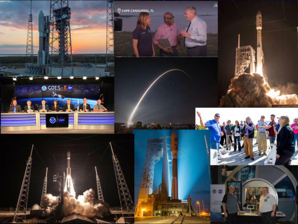
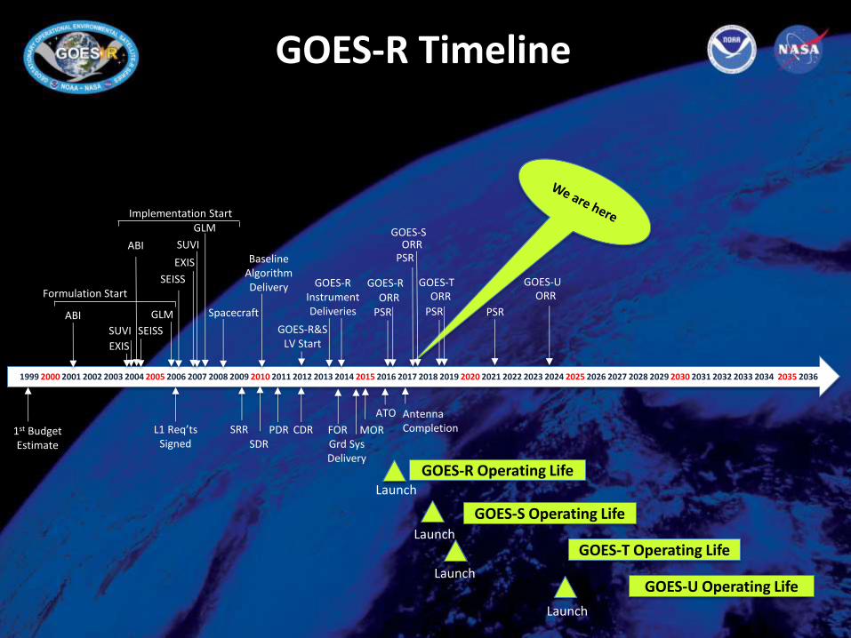
GOES-R The Nation’s Next- Generation Geostationary Weather Satellites Steve Goodman GOES-R Program Senior Scientist National Academy of Science Space Studies Board Spring Meeting Washington, DC May 4, 2017
Transcript
GOES-R The Nation’s Next-
Generation Geostationary
Weather Satellites
Steve Goodman GOES-R Program
Senior Scientist
National Academy of Science
Space Studies Board Spring Meeting
Washington, DC
May 4, 2017
2
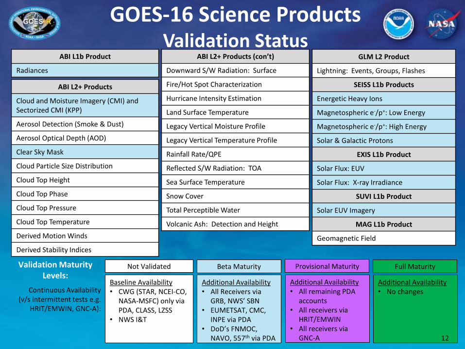
GOES-R Series Spacecraft
3
Extreme Ultraviolet and X-Ray Irradiance Sensor (EXIS)
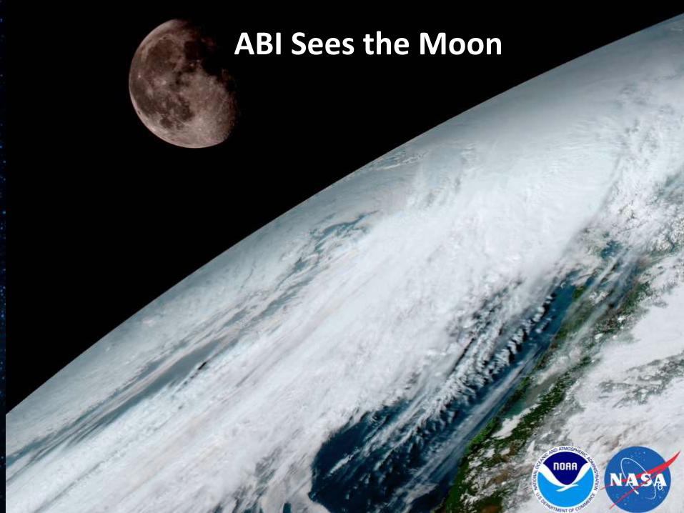
Cloud and Moisture Imagery (CMI) and Sectorized CMI (KPP)
Aerosol Detection (Smoke & Dust)
Aerosol Optical Depth (AOD)
Clear Sky Mask
Cloud Particle Size Distribution
Cloud Top Height
Cloud Top Phase
Cloud Top Pressure
Cloud Top Temperature
Derived Motion Winds
Derived Stability Indices
ABI L2+ Products (con’t)
Downward S/W Radiation: Surface
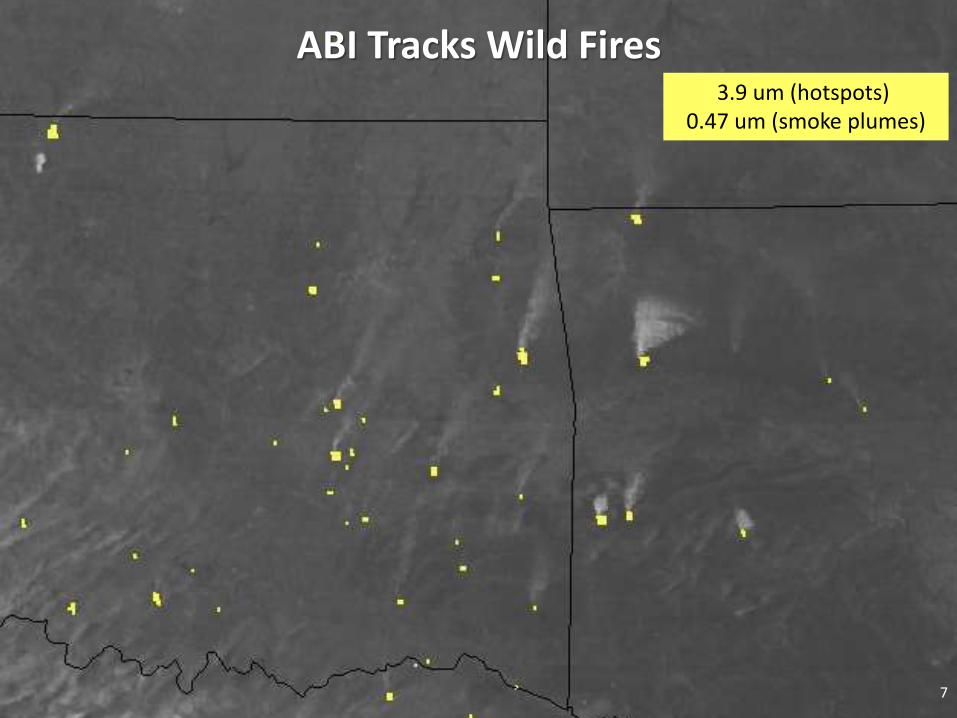
Fire/Hot Spot Characterization
Hurricane Intensity Estimation
Land Surface Temperature
Legacy Vertical Moisture Profile
Legacy Vertical Temperature Profile
Rainfall Rate/QPE
Reflected S/W Radiation: TOA
Sea Surface Temperature
Snow Cover
Total Perceptible Water
Volcanic Ash: Detection and Height
GLM L2 Product
Lightning: Events, Groups, Flashes
SEISS L1b Products
Energetic Heavy Ions
Magnetospheric e-/p+: Low Energy
Magnetospheric e-/p+: High Energy
Solar & Galactic Protons
EXIS L1b Product
Solar Flux: EUV
Solar Flux: X-ray Irradiance
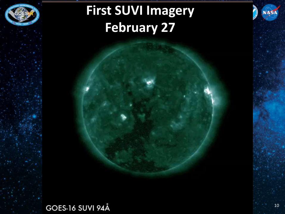
SUVI L1b Product
Solar EUV Imagery
MAG L1b Product
Geomagnetic Field
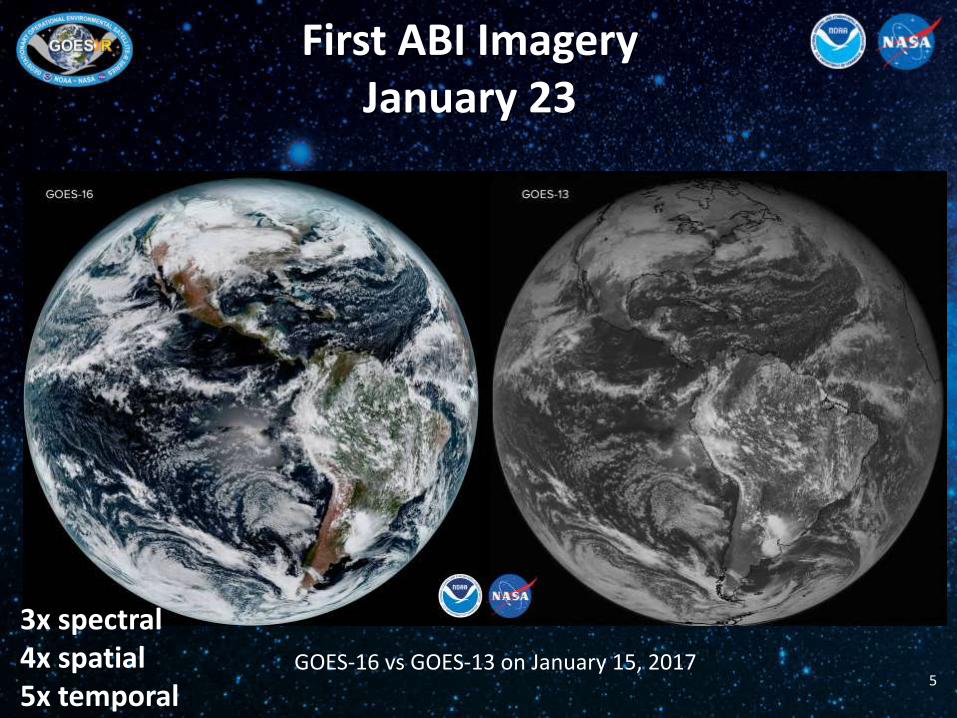
ABI L1b Product
Radiances
Full Maturity Beta Maturity Not Validated Provisional Maturity Validation Maturity Levels:
Continuous Availability (v/s intermittent tests e.g.
HRIT/EMWIN, GNC-A):
Additional Availability • No changes
Additional Availability • All Receivers via
GRB, NWS’ SBN • EUMETSAT, CMC,
INPE via PDA • DoD’s FNMOC,
NAVO, 557th via PDA
Baseline Availability • CWG (STAR, NCEI-CO,
NASA-MSFC) only via PDA, CLASS, LZSS
• NWS I&T
Additional Availability • All remaining PDA
accounts • All receivers via
HRIT/EMWIN • All receivers via
GNC-A 12
GOES-16 Science Products Validation Status
13
The GOES-R PLT Field Campaign
March 21-May 18
14
Satellite Program Validation Field Campaigns
» Committee on Earth Observation Satellites (CEOS) and WMO GSICS recognized best practice: http://qa4eo.org/docs/QA4EO-WGCV-IVO-CLP-004_vDraft.pdf
» Field campaigns are essential for collecting reference data that can be directly related to satellite observations Reference data:
o Collected in ideal validation conditions using well calibrated reference sensors o Used to validate and characterize post-launch instrument performance
» Field campaigns are implemented on all major satellite programs to ensure post-launch validation of system performance (Ex: MODIS, ASTER, AIRS, S-NPP/CrIS & VIIRS, Landsat, SeaWIFS, OCO-2, GPM, TRMM) Often field campaigns are funded separately at the L1b and individually for select
L2+ products The GOES-R field campaign provides a coordinated programmatic approach that
consolidates these efforts in support of L1b & L2+ products
Independent Validation of Predicted Performance: ABI radiometric accuracy (5 % or 1 K uncertainty) GLM flash detection efficiency (70 %) & false alarm rate (5 %)
Goal of the GOES-R field campaign is to support post-launch validation of ABI and GLM L1b & L2+ products:
− ~10 weeks (~100 flight hours)
− March – May 2017
− High-altitude NASA ER-2 platform coordinated with ground based reference data over several Earth targets
− Underflights to be collected, when possible, with low Earth orbit environmental satellites which may include S-NPP, Terra/Aqua, METOP, Landsat, ISS & GPM
− Open access data policy, web portal
− NCEI long-term archive
GOES-R Spacecraft
17
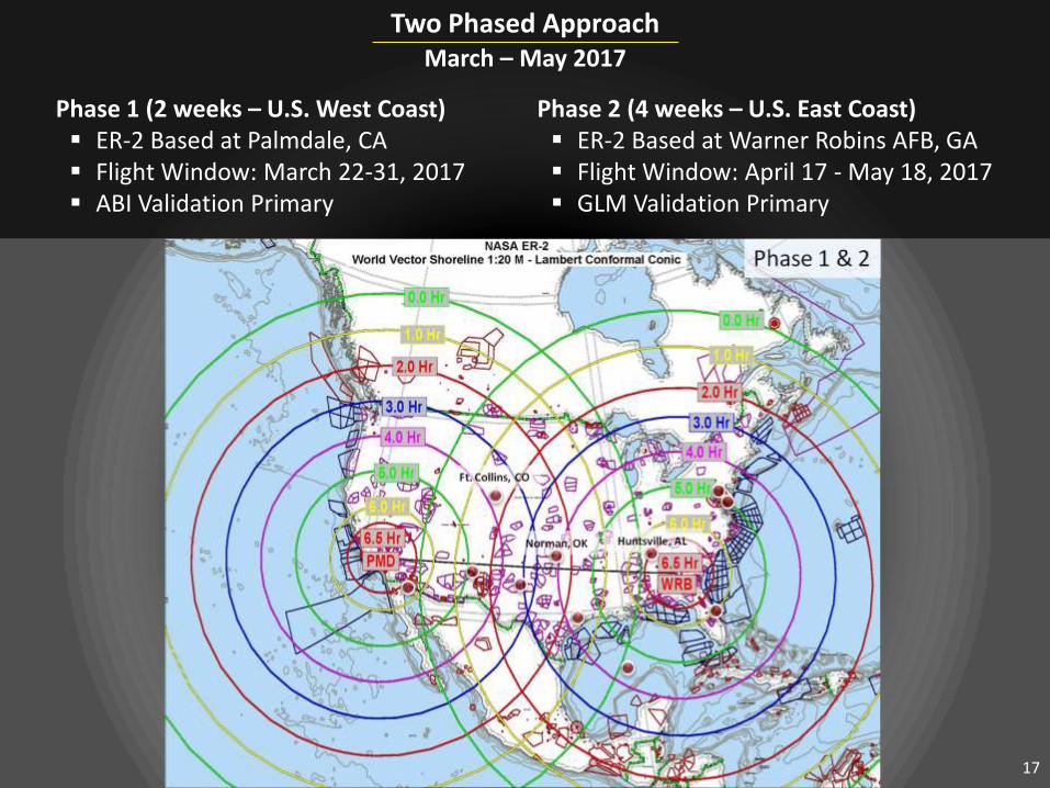
Two Phased Approach
March – May 2017
Phase 2 (4 weeks – U.S. East Coast) ER-2 Based at Warner Robins AFB, GA Flight Window: April 17 - May 18, 2017 GLM Validation Primary
Phase 1 (2 weeks – U.S. West Coast) ER-2 Based at Palmdale, CA Flight Window: March 22-31, 2017 ABI Validation Primary
ABI reflective solar band primary validation flight
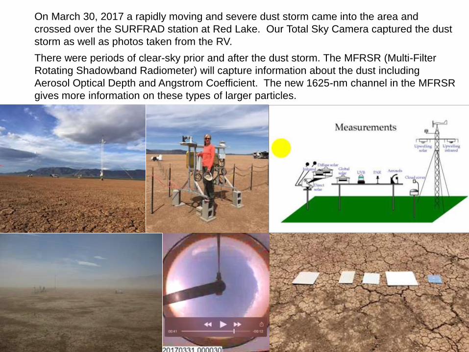
On March 30, 2017 a rapidly moving and severe dust storm came into the area and
crossed over the SURFRAD station at Red Lake. Our Total Sky Camera captured the dust
storm as well as photos taken from the RV.
There were periods of clear-sky prior and after the dust storm. The MFRSR (Multi-Filter
Rotating Shadowband Radiometer) will capture information about the dust including
Aerosol Optical Depth and Angstrom Coefficient. The new 1625-nm channel in the MFRSR
gives more information on these types of larger particles.
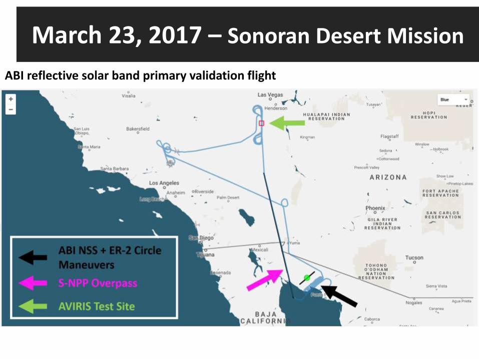
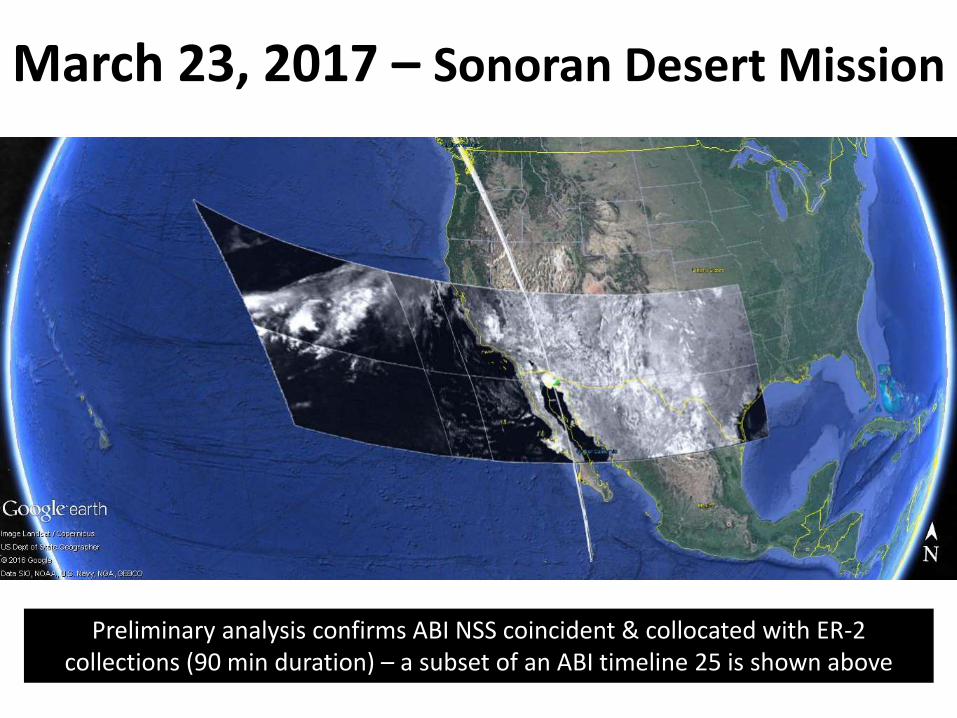
March 23, 2017 – Sonoran Desert Mission
Preliminary analysis confirms ABI NSS coincident & collocated with ER-2 collections (90 min duration) – a subset of an ABI timeline 25 is shown above
ER-2 Flight Track
March 23, 2017 –Two sets of ER-2 consecutive circle patterns (20 circles total) conducted to match the AVIRISng high-altitude aircraft based sensor view geometry with ABI over the Sonoran Desert
24
25
26
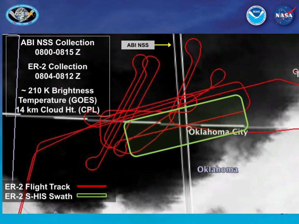
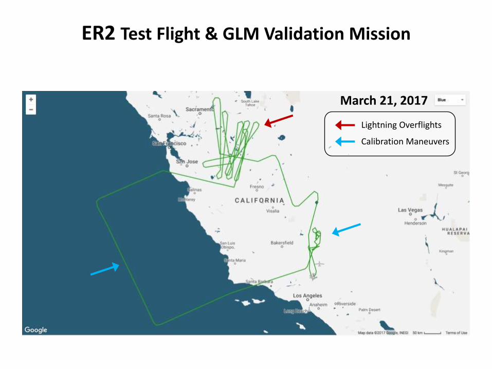
ER2 Test Flight & GLM Validation Mission
Lightning Overflights
Calibration Maneuvers
March 21, 2017
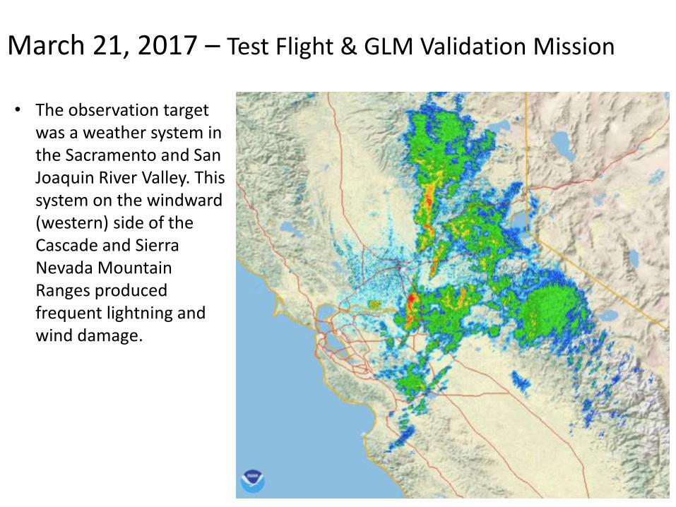
March 21, 2017 – Test Flight & GLM Validation Mission
• The observation target was a weather system in the Sacramento and San Joaquin River Valley. This system on the windward (western) side of the Cascade and Sierra Nevada Mountain Ranges produced frequent lightning and wind damage.
A 10 minute period with 300 GLM events (BLUE) FEGS events (RED) along the flight path
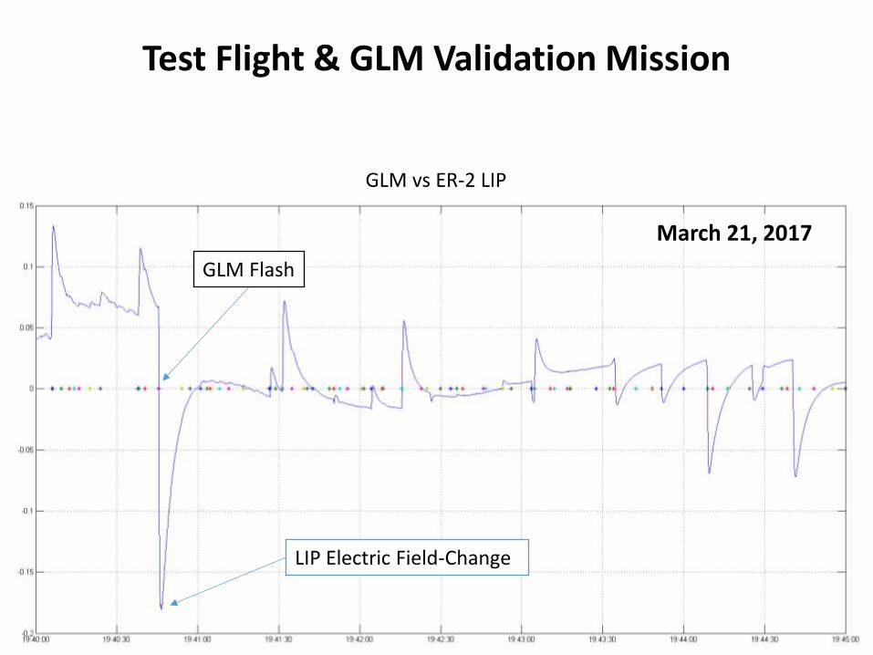
Test Flight & GLM Validation Mission
March 21, 2017
GLM vs ER-2 LIP
LIP Electric Field-Change
GLM Flash
Summary
• GOES-16 launch 19 November, currently in post-launch testing at 89.5 W for 1-year, ABI imagery via GRB after March 1
• ER2 airborne 10-week field campaign March 21-May 18 concurrent measurements with other satellites and ground-based reference sites to calibrate and validate ABI and GLM performance and L2 products.
• Planned announcement in May-June for the GOES-16 operational location beginning November 2017.
32
Thank you For more information visit www.goes-r.gov
www.facebook.com/GOESRsatellite
www.youtube.com/user/NOAASatellites
twitter.com/NOAASatellites
www.flickr.com/photos/noaasatellites
Back-Up
34
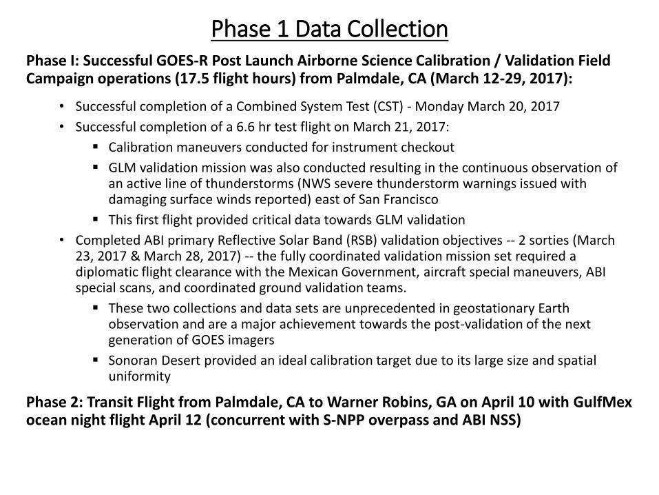
Phase 1 Data Collection Phase I: Successful GOES-R Post Launch Airborne Science Calibration / Validation Field Campaign operations (17.5 flight hours) from Palmdale, CA (March 12-29, 2017):
• Successful completion of a Combined System Test (CST) - Monday March 20, 2017
• Successful completion of a 6.6 hr test flight on March 21, 2017:
Calibration maneuvers conducted for instrument checkout
GLM validation mission was also conducted resulting in the continuous observation of an active line of thunderstorms (NWS severe thunderstorm warnings issued with damaging surface winds reported) east of San Francisco
This first flight provided critical data towards GLM validation
• Completed ABI primary Reflective Solar Band (RSB) validation objectives -- 2 sorties (March 23, 2017 & March 28, 2017) -- the fully coordinated validation mission set required a diplomatic flight clearance with the Mexican Government, aircraft special maneuvers, ABI special scans, and coordinated ground validation teams.
These two collections and data sets are unprecedented in geostationary Earth observation and are a major achievement towards the post-validation of the next generation of GOES imagers
Sonoran Desert provided an ideal calibration target due to its large size and spatial uniformity
Phase 2: Transit Flight from Palmdale, CA to Warner Robins, GA on April 10 with GulfMex ocean night flight April 12 (concurrent with S-NPP overpass and ABI NSS)
Phase 2 Data Collection Phase 2: (27 flight hours) from Warner Robins, GA (April 16-29, 2017):
• Completed 6 sorties to date towards GLM primary validation objectives
• Each sortie was tailored to satisfy GLM primary field campaign validation objectives.
• All missions conducted with ABI 30-second imagery coincident and collocated with the ER-2 aircraft:
April 16, 2017 (7.8 hr mission) - Targeted a large Mesoscale Convective System (MCS)
during the transition from late night into daylight hours that produced near continuous
lightning over the northern range of the Norman, OK total lightning supersite.
April 18, 2017 (6.2 hr mission) - Collected nearly 2 hours of compact low flash rate lightning
over the Northern Alabama total lightning supersite and Atlanta, GA LMA during daylight
hours. This sortie also provided ~2 hrs of convective initiation collection for ABI L2+ product
validation.
April 20, 2017 (7 hr mission) - Targeted northern latitude lightning over the Toronto LMA from
a line of organized storms that produced horizontally extensive and high flash rate lightning
observed during the transition from twilight to night conditions.
April 22, 2017 (5.9 hr mission)- Collected data over afternoon severe storms in northwest
Alabama and southern Tennessee with reports of golf ball size hail and concurrent with
tornadoes on the ground, all within range of the North Alabama Supersite. In addition the
NOAA P3 and UAH mobile research radars, profilers, and lightning detectors were in place
throughout the severe storms.
April 27, 2017 (5.3 hr mission) - 2.5 hours of horizontally extensive low-flash-rate
thunderstorm data collected over the northern Alabama supersite. ER-2 flew over a large
active fire along the FL/GA border for ABI validation.
April 29, (7.9 hr mission) - 4 hours of nighttime data of high-flash-rate supercellular
thunderstorms coincident with the Norman, OK supersite. ER-2 overflight of deep convective
clouds with GOES-16 ABI NSS.
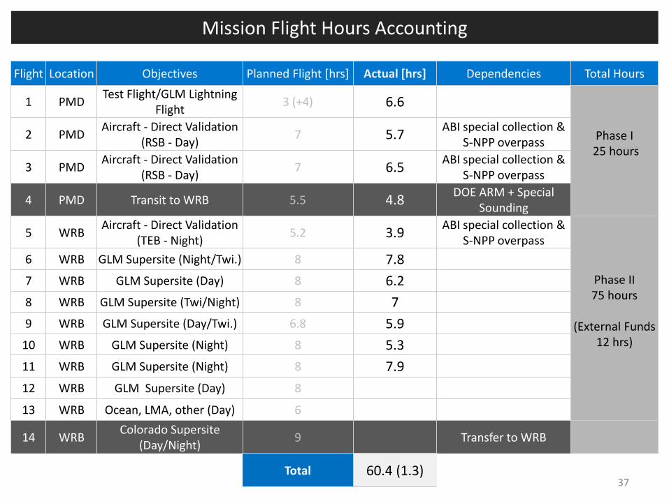
Mission Flight Hours Accounting
37
Flight Location Objectives Planned Flight [hrs] Actual [hrs] Dependencies Total Hours
1 PMD Test Flight/GLM Lightning
Flight 3 (+4) 6.6
Phase I 25 hours
2 PMD Aircraft - Direct Validation
(RSB - Day) 7 5.7
ABI special collection & S-NPP overpass
3 PMD Aircraft - Direct Validation
(RSB - Day) 7 6.5
ABI special collection & S-NPP overpass
4 PMD Transit to WRB 5.5 4.8 DOE ARM + Special
Sounding
5 WRB Aircraft - Direct Validation
(TEB - Night) 5.2 3.9
ABI special collection & S-NPP overpass
Phase II 75 hours
(External Funds
12 hrs)
6 WRB GLM Supersite (Night/Twi.) 8 7.8
7 WRB GLM Supersite (Day) 8 6.2
8 WRB GLM Supersite (Twi/Night) 8 7
9 WRB GLM Supersite (Day/Twi.) 6.8 5.9
10 WRB GLM Supersite (Night) 8 5.3
11 WRB GLM Supersite (Night) 8 7.9
12 WRB GLM Supersite (Day) 8
13 WRB Ocean, LMA, other (Day) 6
14 WRB Colorado Supersite
(Day/Night) 9 Transfer to WRB
Total 60.4 (1.3)
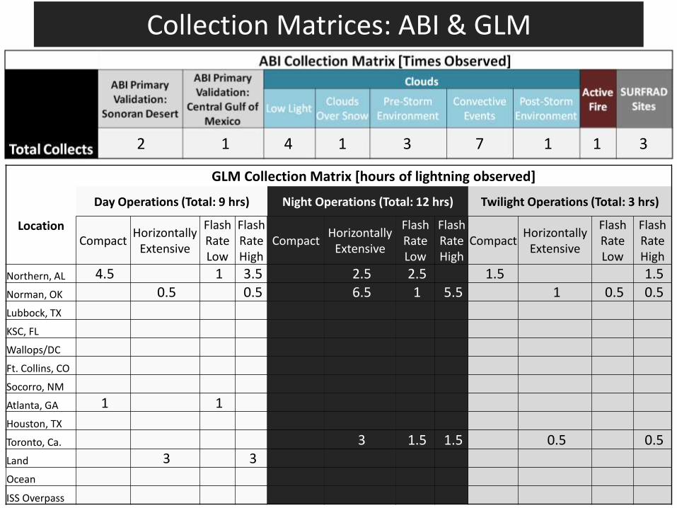
GLM Collection Matrix [hours of lightning observed]
Location
Day Operations (Total: 9 hrs) Night Operations (Total: 12 hrs) Twilight Operations (Total: 3 hrs)