The Port of San Francisco Caught Between Public Trust and Private Dollars June 2014 City and County of San Francisco Civil Grand Jury 2013-2014 City Hall 1 Dr. Carlton B. Goodlett Pl, San Francisco, CA 94102 Phone 415-554-6630
Transcript
The Port of San Francisco
Caught Between Public Trust and Private Dollars
June 2014
City and County of San Francisco Civil Grand Jury 2013-2014
City Hall
1 Dr. Carlton B. Goodlett Pl, San Francisco, CA 94102 Phone 415-554-6630
!
ii
MEMBERS OF THE 2013-2014
CIVIL GRAND JURY
CITY AND COUNTY OF SAN FRANCISCO
Elena Schmid, Foreperson
Robert van Ravenswaay, Foreperson Pro Tem
Thomas Duda, Recording Secretary
Maryta Piazza, Corresponding Secretary
Larry Bush
Hans Carter
Daniel Chesir
Barbara Cohrssen
Mike Ege
John Finnick
Kai Forsley
Charles Head
David Hoiem
Joseph Kelly
Mazel Looney
Claudia O’Callaghan
Ernestine Patterson
Michael Skahill
iii
THE CIVIL GRAND JURY
The Civil Grand Jury is a government oversight panel of volunteers who serve for one year. It makes findings and recommendations resulting from its investigations.
Reports of the Civil Grand Jury do not identify individuals by name.
Disclosure of information about individuals interviewed by the jury is prohibited. California Penal Code, Section 929
STATE LAW REQUIREMENT California Penal Code, section 933.05
Each published report includes a list of those public entities that are required to respond to the Presiding Judge of the Superior Court within 60- to 90 days, as specified. A copy must be sent to the Board of Supervisors. All responses are made available to the public. For each finding the response must:
1) agree with the finding, or 2) disagree with it, wholly or partially, and explain why.
As to each recommendation the responding party must report that:
1) the recommendation has been implemented, with a summary explanation; or 2) the recommendation has not been implemented but will be within a set timeframe as
provided; or 3) the recommendation requires further analysis. The officer or agency head must define
what additional study is needed. The Grand Jury expects a progress report within six months; or
4) the recommendation will not be implemented because it is not warranted or reasonable, with an explanation.
iv
TABLE OF CONTENTS ISSUE ...................................................................................................................................... 1!
The Port of San Francisco is facing daunting challenges to fulfill Public Trust obligations. The Port’s piers, all of which were built over a hundred years ago, are deteriorating and many capital improvements have been deferred for decades. The recent trend of the Port has been to negotiate selling or encumbering precious Port property and signing agreements for the City to forego tax benefits in exchange for massive funding from private developers. The Jury investigated whether there are other options for the use and development of Port property that better meets the desires and needs of the City's residents. Of equal concern is whether there is sufficient public input in determining the best ways to meet Public Trust requirements.
SUMMARY In response to a citizen’s complaint regarding politically connected developers seeking to override the Waterfront Land Use Plan for profit, the Jury investigated Port operations and how decisions are made. A New Waterfront Maritime and Land Use Plan The time has come to revisit the nearly two-decades-old Waterfront Land Use Plan, adding additional focus on maritime roles and ensuring that the public is fully engaged in the process of setting guidelines for the Port’s future. Change Driven by Political Agendas The Jury has found that the Port is making substantive progress in some areas, but is hamstrung by operational burdens placed by other City entities, primarily the Planning Department and the Mayor’s office. Over the past years, the Port also has not maintained the past level of outreach to the general public, instead relying more heavily on the City’s officials to guide decisions. A New Port Commission An important element in ensuring that the Port’s future and its planning is the product of greater public input, the Jury recommends a charter amendment to change the appointment of Port Commissioners. The current system authorizes the mayor to make all five appointments as required per Section 12 of the Burton Act1. Mayoral appointments do not involve a public application process or consideration of any candidate not named by the mayor. It is recommended that the Board of Supervisors make two Port Commission appointments and the Mayor make three. Appointments made by the Board of Supervisors undergo a more public process of applications, hearings and votes before taking office. Candidates also are required to publicly disclose their financial interests in advance of Board consideration, allowing for a review of potential conflicts of interest. This process is unique to Board of Supervisor appointments. Each of these features allows for greater citizen involvement and discussion of the Port’s future. This system of sharing authority in critical land use and economic decisions fits the city’s current approach of dividing appointments between the Mayor and the Board for the 1 The Burton Act, Reflecting All Amendments Through May 1994, p.11, http://sfport.com/ftp/uploadedfiles/about_us/divisions/planning_development/projects/Burton%20Act.pdf
2
Planning Commission, the Board of Permit Appeals, and the Building Inspection Commissions, among others. A “Pig in a Poke” In 1968, the citizens of San Francisco received a valuable asset. The Burton Act transferred 7.5 miles of San Francisco Bay waterfront property and piers held by the State of California to the City of San Francisco. However, like many gifts, there were obligations attached. The infrastructure was deteriorating, the historic structures were crumbling, and the primary source of revenue, cargo movement, had been steadily decreasing since WWII. At the time of the transfer, no economic analysis was done on costs to be incurred by the City and Port or the State’s role in meeting those costs. A proposal by Leo McCarthy, representing San Francisco in the California State Assembly, sought state underwriting for the San Francisco port bond costs, but failed to gain approval. Now, 46 years later, very little has changed except that the cost of rehabilitation of the aging infrastructure has ballooned to $1.59 billion while oversight and restrictions on development have increased. Maritime’s Role Can Be Increased The Jury has noted that, in fiscal year 2012/13, only 6% of the Port’s revenue came from cargo services with another 2% from “Other Maritime.” Most revenue (85%) comes from commercial and industrial, parking, fishing, cruise, harbor services, and ship repair. The remaining 7% is classified as “Other.” 2 Current Challenges Visitor and commuter traffic along the Waterfront create gridlock, necessitating improved transit solutions. The cumulative effect of multiple projects requires close cooperation with SFMTA and the Planning Department. Projects that change the landscape of the Waterfront have also presented challenges to measured growth. This report looks at how some developments have had insufficient public input. Notable Accomplishments The Jury would be remiss if we did not acknowledge that the Port, although operating in a very difficult environment of budgetary constraints, regulatory oversight, and political influence, has in many instances successfully carried out its mission and greatly enhanced the area of its jurisdiction. This is not meant to be a comprehensive list but simply an illustration of the many projects that merit praise.
! Primarily a real estate and land bank, the Port is responsible for monitoring about 550 Port agreements (i.e. leases, licenses, parking permits, etc.) with 394 tenants. These agreements range from month-to-month terms for a sidewalk kiosk renting kayaks to 66-year leases for cargo and ship repair facilities. All businesses operating on Port property have some form of rental agreement, which in addition to a fixed rate may include
2 Port Commission, “Independent Auditor’s Report, Management’s Discussion and Analyusis and Financial Statements For the Years Ended June 30, 2013 and 2012”
3
revenue sharing. The Real Estate Division is doing an excellent job managing the various lease terms and finding new tenants.
! The Ferry Building is the heart of the waterfront. Formerly simply a somewhat rundown building that commuters passed through to walk to downtown, it is now a vibrant destination in itself. Expansion of the terminal from Pier 2 to Pier 14 will increase capacity beyond the current 130 daily ferry visits.
! The Exploratorium relocation from the Palace of Fine Arts to Pier 15 is a welcome addition to the waterfront. The Bay Observatory Gallery focuses on the geography, history, and ecology of the San Francisco Bay region.
! Pier 45 houses the largest commercial fish processing facility on the West Coast, keeping the fishing industry active at Fisherman’s Wharf.
! AT&T Park is recognized as the finest baseball park in the Major Leagues. As of September 2013, the park has hosted a record-breaking streak of 240 consecutive sellout games.3 The venue also hosts live performances and free simulcasts of the San Francisco Opera.
! Steamboat Point and Delancey Street add much needed affordable and supportive housing to San Francisco residents.
! Anchor Brewing, in business in San Francisco since 1896, is expanding its operations to Pier 48 to take advantage of water transport for its raw materials and waste products.
! The Illinois Street multi-modal bridge and the recently approved Quint Street spur are essential to the Port’s objective of increasing rail access for cargo movement in the Southern Waterfront.
! The Port has developed or planned over twenty parks, plazas, open space, and fishing piers as well as links to the Bay Trail.4
3 San Jose Mercury News, September 23, 2013, http://www.mercurynews.com/giants/ci_24158014/san-francisco-giants-ghostly-sellout-streak-still-intact 4 Port of San Francisco, Parks and Open Space, http://www.sfport.com/index.aspx?page=60
4
BACKGROUND
The Port’s jurisdiction consists of 7.5 miles along the bay waterfront running from the Hyde Street pier in the northern waterfront down to India Basin in the southern part. Prior to 1968, this waterfront area was controlled and operated by the State of California. In 1968, the control and management of this waterfront area was transferred to the Port via the Burton Act, AB2649, in trust for the people of California. The Port owns and manages about 39 piers, 43 inland seawall lots, 80 substructures, and 245 commercial and industrial buildings. Seawall lots are tidelands that were filled and cut off from the waterfront by the construction of a seawall in the late 19th and early 20th centuries, now occupied by the Embarcadero roadway. Most of the seawall lots are primarily used for parking. “As part of the transfer agreement, the port acquired $53 million dollars of bonded indebtedness and a requirement to spend $100 million dollars on shipping and cargo-handling improvements. This requirement, later reduced to $25 million, forced the port to look to commercial developments to generate the income that would pay for these improvements. Many proposals were hotly contested. What made this such a predicament were layers of regulation on the one hand and lack of a clear planning vision on the other. Use of port land is subject to restrictions by numerous agencies, including the State Lands Commission (the port owns its land in trust for the people of California), the Bay Conservation and Development Commission (BCDC), and the City Planning Department. The result has been a de facto ban on office and housing development on port property, which other ports around the world tend to have encouraged. The complexity of permit processing and inter-agency coordination has undermined even non-controversial proposals-primarily projects that involve maritime or maritime-related uses.”5 The Port is like a city unto itself with numerous departments. For example, the Port has its own real estate, accounting, planning and development, and legal departments.6 Under the terms of the transfer from the State, San Francisco was required to create a Port Commission and to receive approvals from various state agencies such as the State Lands Commission and the regional Bay Conservation and Development Commission. There are now eighteen regulatory agencies, from Federal to City level, that have some degree of oversight ensuring that provisions focused on maritime use are honored. The Port Commission is comprised of five members appointed by the Mayor and confirmed by the Board of Supervisors. Commissioners serve a four-year term. In 1955 the City’s waterfront was the focus of a “citizen revolt” when a double-decker freeway was announced that would run along the waterfront, effectively cutting the City off with a concrete wall. It opened in 1959. Another freeway expansion across San Francisco drew 200,000 people in 1964 to protest, dooming further expansion of freeways including on the waterfront. During this era, developers proposed a series of high-rise towers along the waterfront, beginning 5 Jasper Rubin, “The Decline of the Port”, November 1, 1999, pub. SPUR http://www.spur.org/publications/article/1999-11-01/decline-port 6 The legal department has five city attorneys assigned to the Port and the planning and development department handles large development projects in conjunction with the Port appointed Citizens Advisory Committees (CACs). The Port has its own set of separate codes: a building code, electrical code, mechanical code, plumbing code, and procedures code.
5
with Fontana Towers approved in 1960 and built in 1963 and 1965 standing 18 stories tall at the edge of Aquatic Park. Other proposals included a 50-story office high-rise on the waterfront. The further implementation of plans for a waterfront of high rises was thwarted by a vote of the Board of Supervisors following a lobbying effort led by Casper Weinberger, a Russian Hill resident (later to be a member of President Reagan’s cabinet). The Board adopted a height limit of 40 feet along the waterfront, with buildings behind stepped down to avoid blocking off the waterfront and reflecting the topography of the hills. In the following decades, San Francisco’s maritime shipping declined in its importance. Larger ships needed better access afforded by increased dredging, which they found in Oakland. The shift from bulk cargo to container shipping reshaped transportation needs, including requiring a rail system that could allow transit for double-stacked containers. The Port’s rail tunnel from the Southern Waterfront does not have sufficient vertical clearance for double-stacked containers. Changes in US Navy vessels also made San Francisco of secondary importance. Instead, ship repair and drydock, the fishing industry, recreation and some remaining bulk cargo maintain a lessened maritime shipping role. Developers saw potential for profit in the repurposing of Port structures and construction on Port lands. San Francisco then sought and obtained approval to amend the definition of “maritime use” to mean activities that increased public activity on the waterfront. With this amended definition, San Francisco narrowly approved Pier 39 in 1979 as a destination for activities ranging from restaurants to themed activities. Fisherman’s Wharf retained its critical function for fish processing and sales, but the land facing the wharves was not under Port authority and became a haven for discount t-shirts, souvenirs and tourist entertainment. Long-established San Francisco businesses and icons like the Buena Vista Cafe and Ghirardelli Chocolate took a back seat. Over the next three-plus decades, San Francisco’s waterfront emerged as a major destination for both City residents and tourists. The northern waterfront, anchored by Fisherman’s Wharf, is connected with an historic streetcar F line to the renovated Ferry Building, a nationally renowned home for locally grown and produced Bay Area foods. A restored waterfront continues south to the new San Francisco Giants ballpark and the new South Beach neighborhood. The development of Seawall Lot 337, now currently a parking lot for the San Francisco Giants, is in planning stages for commercial and residential use. Further to the south Pier 70 is well along in the approval process for development of commercial, residential and open space. A bond measure paid for creation of a new waterfront park and a major pedestrian pier into the Bay allowing visitors and residents to take in the panorama of the City’s waterfront. Recent Changes The waterfront has gone through massive changes since the demolition of the Embarcadero Freeway in 1991.
! The conversion of the Ferry Building from a disembarkation point for ferry passengers to a destination for all residents
! Construction of the Giant’s ballpark, initially included in the Waterfront Land Use Plan ! Construction of the largest fish processing facility on the West Coast at Pier 45 ! The addition of the historic streetcar F-Line from Upper Market to Fisherman’s Wharf ! Affordable housing at Delancey Street and Steamboat Point
6
! Construction of South Beach Harbor ! Relocation of the Exploratorium ! Cruise ship terminal at Pier 27
Not all changes have been positive.
! Cargo movement in the Southern Waterfront has suffered a massive decline over the last ten years
! Capital improvements made at Piers 80 and 94-96 to increase freight container handling embraced outmoded technology and are virtually unused today
! The Embarcadero roadway has become severely congested, hampering the movement of transit, emergency, and private vehicles
Recent Proposals There have been attempts in the immediate past for developments or projects that would enhance the City and the Port. Three listed below have been notable failures. America’s Cup
! Planning by the Port and the Mayor’s Office for the America’s Cup failed to include agreements that protected the City’s interests and failed to maximize the benefits that the City might have achieved. The usual agreement for sharing revenue from the proceeds of use of Port facilities was not included in the agreement.
! A new cruise ship terminal, built at considerable Port cost, was made available with no return to the City even though the America’s Cup sponsors promoted concerts and viewing suites that potentially resulted in large profits for the sponsors and nothing to the Port.
! The Port and the City lost a combined $11.5M on the event.
Proposed Golden State Warriors Arena Although no longer planned for construction on Piers 30-32, the trajectory of the proposal merits attention.
! Attempted fast-tracking of the approval process by the Mayor’s Office to have a “legacy project”
! Very little outreach to community members and neighborhood groups that would have been be affected
! Increased traffic flow and transit needs on the Embarcadero were glossed over ! Hiring former mayoral staffers to facilitate the approval process, leading to the
impression that the public role was secondary to the Mayor’s interest. 8 Washington Street
! Strongly pushed for approval by the Mayor’s office, including testimonials in TV commercials by the Mayor.
! Substantial contributions were made to non-profit organizations by the developer. These organizations subsequently endorsed the project.
! Defeated in two ballot measures by a 2:1 margin
7
Funding Options Most recently, the Port and the Mayor’s office have been overly reliant on funds from major real estate developers. In return for a capital infusion, the developer receives long-term leases and tax benefits, as well as all the profit from the proposed development. The Port benefits from mitigation of its liability for rehabilitation. The Port and the City receive no revenue for decades. This model for development is compatible with the priorities of the City and the Port.7 Developmental benefits derived include affordable housing, small industry, historic reconstruction and open space. Alternatively, there are many other potential sources of funds.
! General Obligation Bonds require 2/3 voter approval. Recreation and Park bond funds are being used to develop Crane Cove Park and a GO bond was passed to improve Pier 22 ½, used by the fireboats.
! Revenue Bonds are currently used, most recently a $30M bond for development of the Cruise Ship Terminal. Use is limited by the ability of the Port to generate revenue
! Federal Funding has recently been approved for extension of freight rail service on Quint Street and in 2005 Federal transportation funds were used to build a bridge on Illinois Street for vehicle and rail access to Pier 80.
! Infrastructure Finance Districts (IFDs) can be formed to issue bonds and divert future tax revenue for up to 30 years to pay for capital improvements.8
! Additional tenant uses such as Teatro ZinZanni, Cirque de Soleil, Cavalia, San Francisco Opera simulcasts, concerts, and other entertainment venues could be placed on vacant piers. These tenants would not require permanent construction.
7 As an enterprise department, the Port is expected to be self-supporting but not necessarily turn a profit. 8 See appendix p.51
8
DISCUSSION
Who is Making Decisions? San Francisco voters, through a series of ballot measures, have established policies and limits on waterfront development and changes. In 1988, voters approved a measure to homeport the USS Missouri in San Francisco with accompanying support from City funds. However, in a few short years, the USS Missouri was decommissioned resulting in the end of that plan. In 1989, voters rejected a measure to build a baseball ballpark on the Waterfront. San Francisco voters in 1996 also approved a ballpark on the waterfront that did not involve City funds, a football stadium that partially replaced a waterfront state park, and a measure allowing the Port Commission to issue revenue bonds without voter approval. Voters also prohibited filling in the Bay in order to add 100 acres to San Francisco International Airport. In related matters, voters approved bond measures to add parks and recreation at the waterfront, improve streets and light rail transportation on the waterfront through issuance of bonds, and funding for a cruise ship terminal.
! The Mayor’s Office o A number of mayors have made it a priority to ensure that the City’s waterfront
remain accessible to people of all income levels, with Mayor Feinstein supporting the Delancey Street housing and jobs center for 500 residents, the Steamboat Point affordable housing complex with 108 one, two and three-bedroom apartments at 800 Embarcadero just north of AT&T Park and a focus on businesses that have strong San Francisco roots. Mayor Agnos, with a close 6-5 vote by the Board, won approval to tear down the Embarcadero Freeway, rejecting Caltrans plans to retrofit and replace the structure. The result was to create renewed economic investment and public access.
o Recent activities at the Port have been closely guided and monitored by the Mayor’s office. The 34th America’s Cup event which garnered a net loss to the City of $5 million, the attempt to have a “legacy project” on piers 30-32, the proposal to build a luxury high-rise condominium development at 8 Washington Street and the rushed construction of an underutilized cruise ship terminal at Pier 27 are examples of influence by the Mayor’s office, with support from the Planning Department.
! The Port Commission
o The Port Commission consists of five members appointed by the Mayor, subject to approval by the Board of Supervisors.
o All other commissions dealing with land use decisions, including Planning, Building Inspection, and Board of Permit Appeals are not appointed solely by the Mayor and consequently may be more responsive to public input.
! Public Forums
o “In San Francisco, successful outcomes are founded on open dialog and diverse partnerships with the many people, organizations and agencies that share a deep interest in improving the Port waterfront for the public. The Port has set up
9
several Community Advisory Groups made up of community stakeholders for all areas along the waterfront. The Advisory Groups meet regularly, which also provides a public forum for interested citizens to participate.”9
o These forums have had mixed success in reaching a consensus of opinion regarding some developments. For major projects requiring zoning changes and exceptions to the Waterfront Land Use Plan there are notable examples of extensive and lengthy community outreach and approval (Pier 70 and AT&T Park) and other examples of meeting minimum requirements (Golden State Warriors, Mission Rock).
o Citizens Advisory Committees (CACs) are also appointed by the Port but are specific to a particular project.
! Public Trust o The Port was conveyed to the City of San Francisco with the mandate to operate
under the ancient Public Trust doctrine, thereby assuring its use for the benefit of all people.
o “The primary doctrine governing all activities at the Port is the preservation of the public trust. The origins of the public trust doctrine are traceable to Roman law concepts of common property. Under Roman law, the air, the rivers, the sea and the seashore were incapable of private ownership; they were dedicated to the use of the public.”10 The formulation of this doctrine in the Justinian Code in 530 C.E11 has withstood the test of time. Its inclusion in the Magna Carta and English Common Law, confirmed by the U.S. Supreme Court in 189212 has been often challenged but never overturned.
Waterfront Land Use Plan13 The Waterfront Land Use Plan provides guidance and priorities for the Port. It defines acceptable and non-acceptable uses and provides general plans for improvements and development of the various sections along the waterfront. Seven goals are stated in Chapter 2:
1) “A Working Waterfront. Port lands should continue to be reserved to meet the current and future needs of cargo shipping, fishing, passenger cruises, ship repair, ferries and excursion boats, recreational boating and other water-dependent activities.
2) A Revitalized Port. New investment should stimulate the revitalization of the waterfront, providing new jobs, revenues, public amenities and other benefits to the Port, the City and the State.
3) A Diversity of Activities and People. Port lands should host a diverse and exciting array of maritime, commercial, entertainment, civic, open space, recreation and other waterfront activities for all San Franciscans and visitors to enjoy.
9 Community Advisory Groups, http://www.sfport.com/index.aspx?page=198 10 Institutes of Justinian 2.1.1., The Public Trust Doctrine, California State Lands Commission, http://www.slc.ca.gov/policy_statements/public_trust/public_trust_doctrine.pdf 11 “By the law of nature these things are common to mankind – the air, running water, the sea, and consequently the shores of the sea. No one, therefore, is forbidden to approach the seashore, provided that he respects habitations, monuments, and buildings which are not, like the sea, subject only to the law of nations.” - See more at: http://onthecommons.org/public-trust-doctrine-venerable-and-besieged#sthash.a6T7RbId.dpuf 12 Illinois Central Railroad v. Illinois, 146 U.S. 387 (1892). - See more at: http://onthecommons.org/public-trust-doctrine-venerable-and-besieged#sthash.a6T7RbId.dpuf 13 Waterfront Land Use Plan, http://www.sfport.com/index.aspx?page=199
10
4) Access Along the Waterfront. A network of parks, plazas, walkways, open spaces and integrated transportation improvements should improve access to and enhance the enjoyment and appreciation of the Bay environment.
5) An Evolving Waterfront, Mindful of Its Past and Future. Improvements should respect and enhance the waterfront's historic character, while also creating new opportunities for San Franciscans to integrate Port activities into their daily lives.
6) Urban Design Worthy of the Waterfront Setting. The design of new developments should be of exemplary quality and should highlight visual and physical access to and from the Bay, while respecting the waterfront's rich historic context and the character of neighboring development.
7) Economic Access Which Reflects the Diversity of San Francisco. The economic opportunities created by commercial uses should be made accessible to persons of both sexes and from a representative variety of ethnic and cultural backgrounds so that those persons receiving these economic opportunities reflect the diversity of the City of San Francisco.”14
! Voter Approval
o In 1990 voters approved a requirement to establish a waterfront land use policy that specifically banned hotels on portions of Port property and also reiterated height limits. The Port Commission adopted the Waterfront Land Use Plan in 1997 following an extensive public outreach and consultation process that involved representatives appointed by the mayor, the Board of Supervisors, community groups and others.
o In 2001, San Francisco voters enacted a charter requirement mandating voter approval of any landfill of 100 acres or more, including defining established piers as landfill.
o In 2004 the Plan was republished as amended by the Port Commission and the Planning Department.
! Revised Waterfront Maritime and Land Use Plan
o The existing Plan has served the Port and the public well during the past 17 years but is now falling short of current needs.
o A revised plan should remain flexible enough to adapt to future unknown requirements while still attempting to forecast future opportunities.
o Maritime use, especially in the Southern Waterfront needs to be emphasized. o Transportation along the waterfront needs to be addressed. o Rising Sea Levels needs to be addressed. o Air quality needs to be addressed. o Housing, both market rate and affordable, needs to be addressed. o Integration with other City departments (i.e. Dept. of Public Works, Public
Utilities Commission, Planning Dept., Mayor’s Office. San Francisco Municipal Transit Agency, Recreation and Parks) needs to be addressed.
o Connection with City residents through community organizations, neighborhood associations, trade organizations, advocacy groups, conservation organizations, educational institutions, etc. should be included
14 Waterfront Land Use Plan, Overall Goals / Highlights, http://www.sfport.com/index.aspx?page=200
11
o A committee to revise the existing Waterfront Land Use Plan could include members of the above-mentioned groups as well as appointees by the Port, the Mayor and the Board of Supervisors.
Port Operations and Priorities The Port’s total operating revenues for the fiscal year ending June 30, 2013 were $81,512,000. Only about 25% of the Port’s total operating revenue comes from maritime operations. The remaining 75% is derived mainly from real estate rental income from Port property leased to private and public entities, parking meters, ticket revenue, and parking stall rentals.15 There are currently about 550 Port agreements (i.e. leases, licenses, parking permits, etc.) with 394 tenants. The reason the agreements exceed the number of tenants is because some tenants have multiple agreements. Most of the leases are smaller industrial type leases (e.g. storage, warehousing, etc.). There are currently about 184 month-to-month leases. The Port Commission must approve all lease terms longer than five years. The Board of Supervisors must approve any lease that generates annual rent of $1 million or more or with a term of more than ten years. The City’s Administrative Code section 23.23 states that any City lease that is expected to produce more than $2,500 per month in revenue is subject to competitive bidding unless it's impractical or impossible to do so. It also provides that it is the City's policy that any lease awarded without following the competitive bidding procedures be in an amount not less than the fair market value of the leased property. The Port does not do competitive bidding unless the proposed leased area is a unique situation. For example, restaurant and parking lot spaces are almost always offered for competitive bidding and usually have longer-term leases (five to ten or more years). Certain City agencies are designated “enterprise agencies.” An enterprise agency is a City department that is supposed to be self-supporting from revenue generated from its own business activities (e.g. rental income from leased property, airport landing fees, user fees) and is not supposed to receive money from the City’s general fund. Examples of City enterprise agencies are the San Francisco Airport and the San Francisco Public Utilities Commission. The Port of San Francisco considers itself to be an enterprise agency, but it does receive money from the general fund in the form of reimbursements for expenses and in the form of lease payments from other City agencies. For example, as is explained in more detail below, the Port received about $4 million in reimbursement from the general fund for expenditures it incurred relating to the hosting of the 34th America’s Cup event.16 Additionally, the City rents out space to various other City agencies (like the MTA, the Department of Elections, the Department of Real Estate, the Department of Public Works, etc.) and receives rent from them, which comes from the general fund.
! Transportation
15 Based on the Port’s Independent Auditor’s Report done by MGO Certified Public Accountants for the years ended June 30, 2013 and 2012, which reports the following Port revenue amounts for the fiscal year ended June 30, 2013: total operating revenues of $81.512 million of which $43.266 million was derived from commercial and industrial real estate rental income and $17.774 million from parking fees 16“Board of Supervisors Budget and Legislative Analyst, Policy Analysis Report,” February 10, 2014, http://www.sfbos.org/Modules/ShowDocument.aspx?documentid=47894
12
o The current transportation system of light rail and vehicular traffic is inadequate. The Embarcadero has been closed to traffic entirely in order to accommodate special needs such as cruise ship passengers arriving or departing. Other events along the waterfront may also result in lengthy backups. Of greater concern, there are times when emergency service vehicles cannot use the roadbed but must instead drive on the light rail tracks.
o The City’s transportation plans so far have not provided a solution, and its
planning for increased traffic resulting from new development would not resolve the current situation but would only attempt to mitigate additional transportation needs. It is critically important that any waterfront future development place heavy emphasis on transportation needs in practice as well as in theory. Adding additional parking, for example, assures additional roadway traffic.
! MUNI T-Third St. Line o To more fully serve the needs of the waterfront, SFMTA (San Francisco
Municipal Transportation Authority) inaugurated limited weekend service along the T-Third Light Rail Muni Metro Line on January 13, 2007.17 The T-Third provides essential service to Port properties south of the Ferry Building and links proposed development project areas at Mission Rock and Pier 70 to Port lands north of Mission Creek.
o In contrast to the 15-Third Bus that the T-Third replaced, which operated in
mixed traffic along city streets, the T-Third has “a nearly exclusive right of way….distinguished by its artistic paving and raised white curbs.”18 Intended as an enhancement to the Third Street route, “...the exclusive track way is a separate lane just for the LRVs [Light Rail Vehicles] that allow them to operate without interference from other traffic.”
o The planning called for new traffic signals to incorporate a “signal
prioritization/pre-emption system” that is designed to speed travel times and minimize delays along its route. At the time that it opened, the T-Third Metro right of way permitted vehicle traffic to make signalized left turns across its parallel, northbound and southbound rails at 31 intersections.19 Signaling systems along T-line Third Street corridor identify approaching Muni Light Rail Vehicles (LRVs) with an electronic system known as VETAG. As a T-line LRV approaches a signal priority-equipped intersection, an electronic signal between a sensor on the LRV and a sensor embedded in the pavement below identifies the LRV to the traffic signal computer. Depending on the configuration of the traffic signal’s computer program, the LRV can either receive priority (if the traffic signal being approached is green it stays green) or preemption (the approached signal automatically turns green for the LRV).
17“Mayor Gavin Newsom Announces Third Street Light Rail to Begin Service January 13,” States News Service, May 2, 2007. Retrieved via LexisNexis, January 12, 2014. [Hereafter cited as “Newsom Announces.”] 18 “Discover the T-Third,” SFMTA, http://www.sfmta.com/cms/mroutes/documents/T3-Manual_v6na.pdf. Retrieved via the Internet Archive WayBack Machine, January 12, 2014. 19 On time performance data for the 15-Third Bus, T-Third Metro, and published timetables for each.
13
o Muni admits that poor maintenance has limited the effectiveness of the VETAG
system along Third Street, slowing T-Line LRVs from moving at their optimal pace. The T sputters along at a pace that is slower than the 15-Third Bus that it replaced.20 Presently, Muni contends that all maintenance problems with VETAG are resolved and that the agency is considering a plan to implement signal preemption at “key” intersections. In light of the T-Line’s slow travel times relative to the retired 15-Third bus, any effort to speed travel along the Third Street corridor is a necessary step toward providing service that can support future development.
It remains to be seen whether this system can now be implemented as planned as well as expanded to carry more passengers.
! Maritime Use
Maritime use at the Port goes well beyond what takes place on ships and boats. There are many land uses authorized by the Waterfront Land Use Plan for activities directly supporting maritime activities. “Maritime land uses include but are not limited to:
! Maritime cargo handling and storage facilities; ! Ship repair facilities; ! Fish processing facilities; ! Marinas and boat launch ramps; ! Ferryboat terminals; ! Cruise ship terminals; ! Excursion and charter boat facilities and terminals; ! Ship berthing facilities ! Maritime construction and maritime supply facilities; ! Marine equipment and supply facilities ! Cargo shipping; ! Ship repair; ! Fishing industry; ! Recreational boating and water use; ! Ferry and excursion boats and water taxis; ! Passenger cruise ships; ! Historic ships; ! Maritime support services; ! Maritime offices; ! Port-priority uses”21
20 Source: On time performance data for the 15-Third Bus, T-Third Metro, and published timetables for each. 21 “Waterfront Land Use Plan”, Section 61.3. Added by Proposition H, 11/6/90; amended by Ord. 7-98, App. 1/16/98
14
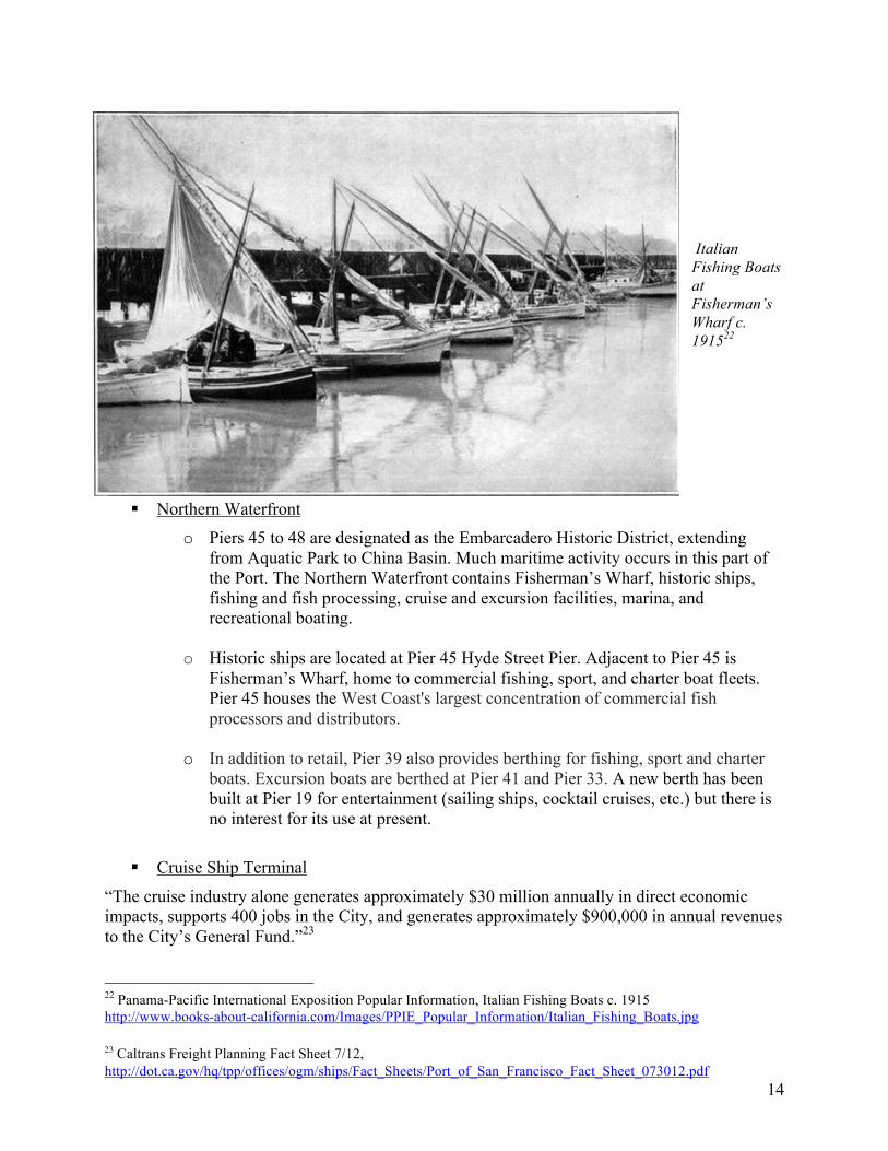
Italian Fishing Boats at Fisherman’s Wharf c. 191522
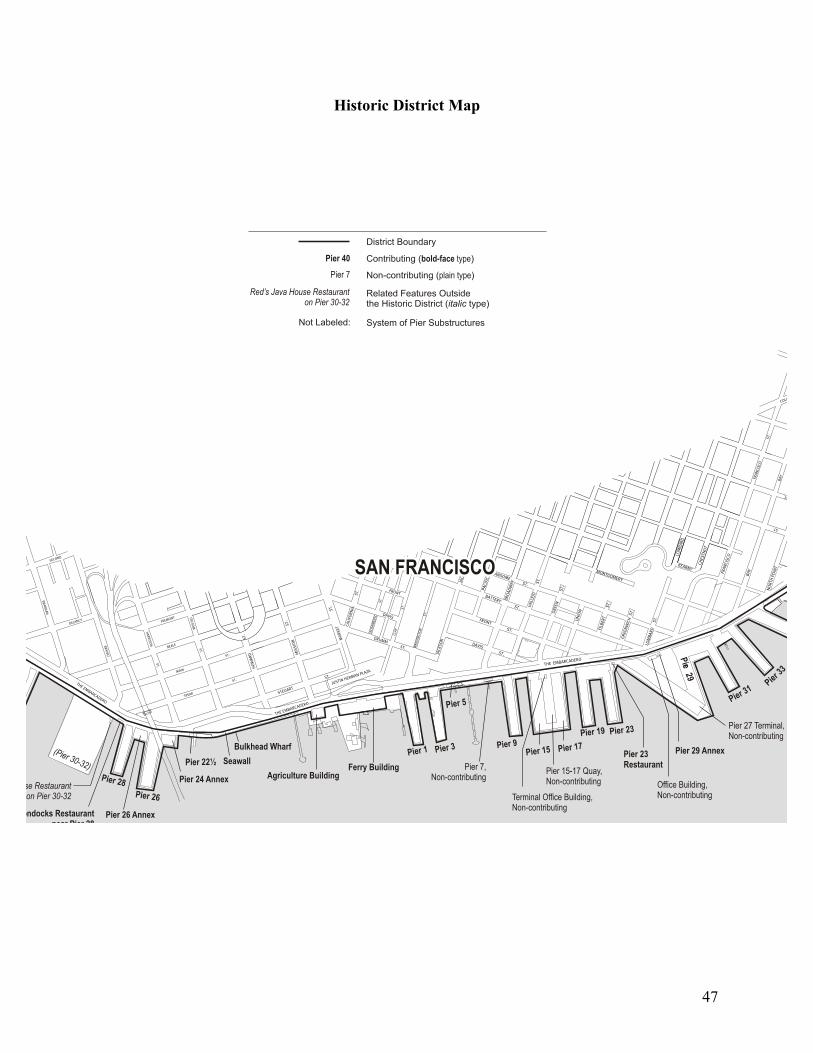
! Northern Waterfront o Piers 45 to 48 are designated as the Embarcadero Historic District, extending
from Aquatic Park to China Basin. Much maritime activity occurs in this part of the Port. The Northern Waterfront contains Fisherman’s Wharf, historic ships, fishing and fish processing, cruise and excursion facilities, marina, and recreational boating.
o Historic ships are located at Pier 45 Hyde Street Pier. Adjacent to Pier 45 is
Fisherman’s Wharf, home to commercial fishing, sport, and charter boat fleets. Pier 45 houses the West Coast's largest concentration of commercial fish processors and distributors.
o In addition to retail, Pier 39 also provides berthing for fishing, sport and charter
boats. Excursion boats are berthed at Pier 41 and Pier 33. A new berth has been built at Pier 19 for entertainment (sailing ships, cocktail cruises, etc.) but there is no interest for its use at present.
! Cruise Ship Terminal
“The cruise industry alone generates approximately $30 million annually in direct economic impacts, supports 400 jobs in the City, and generates approximately $900,000 in annual revenues to the City’s General Fund.”23
22 Panama-Pacific International Exposition Popular Information, Italian Fishing Boats c. 1915 http://www.books-about-california.com/Images/PPIE_Popular_Information/Italian_Fishing_Boats.jpg 23 Caltrans Freight Planning Fact Sheet 7/12, http://dot.ca.gov/hq/tpp/offices/ogm/ships/Fact_Sheets/Port_of_San_Francisco_Fact_Sheet_073012.pdf
15
A new Cruise Ship Terminal is under construction at Pier 27. Upon completion it is projected to handle 40 to 80 calls per year. Plans to increase utilization of the Port’s new Cruise Ship Terminal need to be formulated. It is now operating at a fraction of its capacity because of the federal Passenger Vessel Services Act of 1886, which requires foreign flagged vessels traveling from one U.S. port to stop at a foreign port before a subsequent stop at a U.S. port. Consequently, there are very few ships docking here, resulting in a substantial loss of potential revenue to the Port. Instead, the major revenue from this location comes from its use as a parking lot. Pier 35, the former cruise terminal will be used for backup. South of Pier 35 are excursion, tug and tow facilities, and San Francisco Bar Pilots at Pier 9.
! Central Waterfront
The Central Waterfront has ferry terminals, the Ferry Building, Exploratorium, Bay Pilots, tugboats, and the Port of SF main office.
! Ferry Building
3,000,000 passengers per year use the piers at the Ferry Building. Ferry service provides minimal revenue to the Port, but is sufficient to pay for the operational costs. Ferry operations are an important part of the public service provided by the Port and are integral to the Water Emergency Transportation Authority (WETA) in the event of a major disaster. Facilities will be expanded to Pier 14. Fireboats are located at Pier 22 ½.
! South Beach/China Basin South Beach Harbor is a recreational boating and docking facility located between AT&T Park and Pier 40. Originally developed by the San Francisco Redevelopment Agency in 1984, it was taken over by the Port in 2012 after the dissolution of state redevelopment agencies. It contains 700 slips and South Beach Park. Pier 48 will house a new Anchor Steam Brewery. This is considered a maritime use because the brewery will use barges to transport raw materials and waste to and from. AT&T Park also has a ferry terminal.
! Southern Waterfront The Southern Waterfront is home to maritime industrial uses. BAE operates a ship repair yard at Pier 70, where there are two drydocks owned by the Port and leased to BAE. The shipyard provides union jobs to 250 to 1500 workers daily, depending on the workload. The port is soliciting interest from qualified respondents for developing and operating a bulk marine cargo-handling terminal at Pier 96, considered an ideal location for transshipping iron ore.
! Cargo Services The Port has the ability to increase its cargo services in the Southern Waterfront. Pier 80 and 94/96 each have three deep-water berths with cranes capable of working both break bulk and containers for off-loading to the on-dock rail lines. There is a combined 145 acres of paved cargo staging area, 550,000 square feet of which is covered storage.
16
“A recent economic benefits study highlights the value of maintaining and expanding industrial uses on Port property. The report4 estimated that Port industrial and maritime tenants generated over $785 million in annual economic activity in San Francisco, and employed roughly 2,400 workers (2011 data).”24 Cargo traffic has been steadily decreasing over the years. In 2004 there were 224 cargo vessel calls, down to 95 in 2005 and only 39 in 2013.25 The Port is soliciting interest from qualified respondents for developing and operating a bulk marine cargo-handling terminal at its underutilized Pier 96. The Port would like to see iron ore transshipped from there. In the mid-to-late 1960s, containerization took hold as the principal means of moving freight. The Port reacted to this trend by building the break-bulk Army Street Terminal (Pier 80) and a LASH terminal (Pier 98); both were outmoded technologies even as they were being constructed. Although it is prudent for the Port to solicit more break-bulk cargo in order to maximize current use, the Jury hopes that there is a greater effort to forecast possible future uses of the Port’s deep-water berths and other maritime facilities.
! Infrastructure and Historic Resources The Port of San Francisco faces serious financial challenges for capital improvements. At the time of transfer to the City in 1968, the Port already faced a deficit for infrastructure repair and maintenance. Under the terms of the Public Trust, all revenue created by the Port is reserved exclusively for its own use. The Port currently receives payments from the General Fund for leases of Port property, and a general obligation bond has been approved for rebuilding Pier 22 ½ for the use of fireboats. Recreation and Park bond monies have been designated for open space improvements at Pier 70. In efforts to meet infrastructure needs as determined by the Port, various developments are under discussion that would advance funds for repairs to be repaid through Port forgiveness of routine financial obligations such as rent payments, real estate transfer taxes, and other revenues that typically are paid to the Port. The issue of the Port’s infrastructure needs as measured against citizen priorities such as open space, recreational spaces, or revenue from more standard leases have not always been properly considered. Proposed Developments and Activities It is significant to note that the projects outlined for Pier 30-32, Mission Rock, and Pier 70 all require zoning changes and exemptions to the Waterfront Land Use Plan. This commonality is indicative of demands from other City departments, requirements for a high return on investment from the developers, and overriding of the Waterfront Land Use plan.
! Pier 30-32 The Port’s piers, all of which were built over a hundred years ago, are deteriorating and capital improvements have been deferred over the years. 26 For example, Pier 30-32, which is located between the San Francisco-Oakland Bay Bridge and the AT&T baseball park, has a remaining 24 Ten-Year Capital Plan FY 2015-2024 Update, Port of San Francisco 25 Port of San Francisco, “Cargo Statistics”, http://www.sfport.com/index.aspx?page=164 26 See Port of San Francisco 2014-2023 Ten-Year Capital Plan.
17
useful life of about ten years, as do most of the other piers. Pier 30-32 is about 900 feet long and 12.5 acres in area and is located on the east side of the Embarcadero at Bryant Street; it is currently used mainly for short-term parking. Since Pier 30-32 has a natural deepwater berth along its east face, (1350 feet in length) it is also occasionally used as a tertiary berth for cruise ships and other deep draft vessels. Seawall Lot 330 is located across the street from Pier 30-32 on the west side of the Embarcadero between Beale and Bryant Streets; it is approximately 2.3 acres of undeveloped land currently used for short-term parking. GSW Arena LLC is an affiliate of the entity that owns the Golden State Warriors, a basketball team in the National Basketball Association. GSW Arena LLC (GSW) had proposed a multi-use development at Pier 30-32 and Seawall Lot 330. GSW’s proposed development project included the following: construction of a new basketball arena on Pier 30-32 with seating for approximately 17,000 to 19,000 persons; rehabilitation of Pier 30-32 to support said arena; and the sale by the Port to GSW of Seawall Lot 330 for construction of residential, hotel, and/or retail uses and accessory parking. In addition to sports events, GSW had indicated its intent to use this arena for more than 150 events such as concerts every year. According to Port documents, in order to support the arena and related structures and address rising sea levels, the cost to rehabilitate Pier 30-32 for the Warriors’ arena would have been substantially higher than the cost to simply rehabilitate and preserve the pier.27 When the GSW proposal was made in 2012, the construction cost estimate for rebuilding and strengthening Pier 30-32 so that it could support the arena structure was $120 million. A third party estimate for the cost of rehabilitating Pier 30-32 to bear the weight of the arena structure was about $171 million.28 The Port’s “Ten-Year Capital Plan FY 2015-2024 Update” estimates the cost to be $165 million.29 The Jury was informed during its investigation that it could have been as high as $180 million. In contrast, according to Port documents, the approximate cost to simply rehabilitate and preserve the pier is estimated by the Port to be $68 million; the approximate cost to simply remove the pier altogether is estimated by the Port to be $45 million.30 Under the 2012 GSW proposal, the Port would have been obligated to reimburse GSW for the cost of rehabilitating Pier 30-32 to support the Warriors’ arena, which at that time was estimated to be $120 million. Under the proposal, GSW would have been entitled to a 13% annual return on said reimbursement amount of $120 million. Payment by the Port of the $120 million rehabilitation cost would have come from the following three sources:
! A purchase credit of $30.4 million from the sale of Seawall Lot 330 to GSW (the fair market value of Seawall Lot 330 was estimated several years ago to be $30.4 million but is most likely higher now);
! A long term lease of Pier 30-32 to GSW with annual rent credits for the next 66 years, which meant that the Port would have received no rent for the lease of Pier 30-32 for the next 66 years (the estimated annual rent for Pier 30-32 once improved was valued at $1.97 million a few years ago);
27 See page 7 of “Memorandum from Monique Moyer to the Port Commission dated 3/18/2013” 28 Based on a third party cost construction estimate dated 1/22/2014 prepared by M Lee Corporation 29 See page 33 of the Port of San Francisco Ten-Year Capital Plan FY 2015-2024 Update 30 See page 7 of “Memorandum from Monique Moyer to the Port Commission dated 3/18/2013” and “Port of San Francisco 2014-2023 10 Year Capital” cited on page 7 of said Memorandum; see link http://www.sfport.com/modules/showdocument.aspx?documentid=5640)
18
! Establishment of an Infrastructure Financing District on Pier 30-32 and Seawall Lot 330 under which a $60 million 30 year bond would have been issued and then repaid with General Fund property tax revenue for the next 30 years.
The above-described GSW proposal is apparently off the table. It was reported in late April of this year that the Warriors have purchased land in the Mission Bay area to construct their basketball arena and no longer have plans to use Pier 30-32 for any development. The City and Port are apparently no longer in negotiations with GSW to use Pier 30-32 for any GSW development. The reason for inclusion of this proposal in this report is to provide the public with a fuller and more detailed understanding of the Port’s negotiations and financial trade-offs it would have accepted under the terms as outlined. The Port is prohibited by state law from selling any of its piers but it is not prohibited per se from selling certain seawall lots, including Seawall Lot 330, under certain Public Trust conditions.31 The Port’s Waterfront Land Use Plan, initially adopted by the Port Commission in 1997, specifies acceptable Public Trust uses for the piers like museums, restaurants, parking, and recreational enterprises, but it does not identify a professional sports arena, like the GSW’s proposed arena, as an acceptable use of Pier 30-32.32 Also, the City’s zoning laws currently limit any development on the piers, including Pier 30-32, to a 40-foot height limit.33 Hence, amendments to both the Waterfront Land Use Plan and the City’s zoning laws would have been necessary before final approval of any such GSW arena project.
Finally, the SF Waterfront Special Area Plan issued by the Bay Conservation Development Commission provides that improvements along the Port waterfront area should have “design policies that promote low-scale development and preserve Bay views.” 34 The plan also states that large piers like Pier 30-32 and Piers 27-29, if redeveloped as a large pier, should have the following: (1) “A higher proportion of their area devoted to public access and open space than Finger Piers; (2) “[p]ublic access provided should consist of:
• Perimeter access • Significant park(s)/plaza(s) on the pier perimeter • Additional areas, e.g., small parks or plazas integrated into the perimeter
access • Significant view corridors to the Bay from points on the pier which by their
location have more of a relationship to the water than to the project • The Bayside History Walk (on Pier 29); and
(3) “Public open spaces within the interior of large piers that do not provide physical or visual proximity to the Bay should not be included in the determination of maximum feasible public access to be provided on the pier.”35 Amendment of the BCDC SF Waterfront Special Area Plan requires 2/3 voter approval of the
31 See e.g. AB 1389 (2001), Senate Bill 815 (2007), and AB 418 (2011)
32 See Port’s Waterfront Land Use Plan, Chapter 4, South Beach/China Basin Acceptable Land Use Table (1,2,3,4)
33 See The Zoning Map of the City and County of San Francisco established by sections 105 and 106 of the City’s Planning Code, Height & Bulk District Maps, Map HT01 34 BCDC SF Waterfront Special Area Plan, page 19 35 BCDC SF Waterfront Special Area Plan, page 34
19
BCDC 27 commissioners (i.e. 18 votes).36
! America’s Cup The America’s Cup is an international sailing competition held every few years. In 2012/2013, the Port and City hosted the 34th America’s Cup event at the waterfront. The event consisted of a series of sailing races. In its Annual Report for Fiscal Year Ended June 30, 2012, the Port estimated that hosting the America’s Cup would result in an aggregate $3.2 million rent loss to the Port during the occurrence of the event. The City ended up spending approximately $20.5 million from the general fund for the event, which included about $4 million of reimbursement to the Port for Port expenditures and lost rent resulting from the event. To help defray some of that cost, the City received about $8.7 million in private fundraising and about $5.8 million in tax revenue, leaving a net loss to taxpayers for the event of about $6 million.37,38 The sources of the tax revenue were transient occupancy taxes (hotel tax) of about $2.35 million, sales taxes of about $1.16 million, payroll taxes of about $1.27 million, and parking taxes of about $1 million. In addition to the loss to the City’s general fund, the Port spent from its own operating revenue about $2.5 million in operating costs (e.g. legal fees, tenant relocation costs, marketing, etc.), and about $3 million in capital expenditures (e.g. dredging, relocation of power lines, etc.). The Port derived no long-term benefit. None of these Port expenditures were reimbursed by the City’s general fund. The total loss to the City and Port for the event amounted to about $11.5 million ($6 million from the general fund plus $5.5 million in unreimbursed Port expenditures). Neither the City nor the Port received any revenue sharing or venue rent from the event. The Port allowed the use of its piers for the staging of the America’s Cup rent free. The City via a Memorandum of Understanding between the City and the Port agreed to reimburse the Port for this loss of rent. The Port was reimbursed $2 million from the general fund.39 The City should clarify when an event hosted by the City needs approval by the Board of Supervisors or when it requires a simple event permit only.
! Pier 70 Pier 70 is in the Central Waterfront and is bounded by Mariposa Street, Illinois Street, 22nd Street, and the San Francisco Bay. In addition to Pier 70 the site includes Pier 68 and part of Seawall Lot 349. It comprises approximately 28 acres containing a mix of heavy commercial and
36 BCDC San Francisco Bay Plan requires the affirmative vote of two-thirds of the members of the Commission to amend the Bay Plan and special area plans, like the SF Waterfront Special Area Plan, are subject to the same procedures for public notice, hearing, and voting as other amendments or changes in the Bay Plan. 37 See San Francisco Budget and Legislative Analyst’s Office report entitled “Analysis of the Impact of the 34th America’s Cup to the City” http://www.sfbos.org/Modules/ShowDocument.aspx?documentid=47894 38 For a fiscal impact analysis, also see The Bay Area Council Institute December, 2013 report “The Economic Impact of the 34th America’s Cup in San Francisco” http://www.bayareacouncil.org/press-releases/bay-area-council-economic-institute-releases-americas-cup-economic-impact-study/ 39 See San Francisco Budget and Legislative Analyst’s Office report entitled “Analysis of the Impact of the 34th America’s Cup to the City” http://www.sfbos.org/Modules/ShowDocument.aspx?documentid=47894
20
light industrial buildings. Current commercial activities include warehousing, contractor and construction storage and until June 2013, the City’s impound facility for towed cars. In the City’s early days, the Pier 70 area became the location of activities that required isolated sites on the outskirts of the downtown area, such as gunpowder manufacturing. As the area became established as a center for industrial operations and shipping in the 1850’s, the serpentine hillsides were blasted away to create street corridors for landside movement along the Bay, and piers were extended over the water. This area offered excellent accessibility by ship to relatively deep offshore waters in the Bay and commercial routes in the Pacific Ocean.40 The Port acquired portions of the waterfront site and the rest of Pier 70 from the State, the federal government, and private parties. Portions of Pier 70 are historic uplands that were never submerged tidelands subject to the Public Trust, and several parcels have been in and out of private and federal ownership, creating a patchwork of parcels subject to Public Trust restrictions.41 The inland areas of the site not subject to Public Trust controls were originally part of the serpentine cliffs surrounding the area, not tidelands that have been filled. This portion is eligible for residential use. Existing historic buildings provide a ready-made footprint for commercial and industrial use. The Pier 70 site is eligible for listing in the National Register of Historic Places as an Historic District for its national significance in the area of maritime industry, beginning with the initial construction of the Union Iron Works Machine Shop (1885-1886) and closing at the end of World War II. Within Pier 70, 44 historic resources have been identified as eligible for listing in the National Register of Historic Places. About half of these structures have been condemned for structural or environmental reasons, and all are rapidly deteriorating, which threatens their historic integrity.42
40 “Pier 70 Preferred Master Plan”, Chapter 1, April 2010, http://sfport.com/ftp/uploadedfiles/about_us/divisions/planning_development/southern_waterfront/pier70masterplan_intro-overview.pdf 41 File No. 130495 Committee Item No. 11 - Board of Supervisors, June 5 2013 http://www.sfbos.org/ftp/uploadedfiles/bdsupvrs/committees/materials/bf060513_130495.pdf 42 “Pier 70 Preferred Master Plan”, Chapter 1, April 2010, http://sfport.com/ftp/uploadedfiles/about_us/divisions/planning_development/southern_waterfront/pier70masterplan_intro-overview.pdf
21
To support the Pier 70 planning effort, the Port retained a team of consultants with technical expertise in the fields of historic preservation, land use economics, urban planning and design,43 environmental analysis, engineering, and cost estimation. In addition, the Port worked through a collaborative process with federal, state, and regional government agencies, other departments
within the City family, and the public. Strong government partnerships have enabled the Port to produce a Plan that is informed by key regulatory considerations and that enjoys strong public consensus. Special attention has been given to ship repair industry needs. The Port has worked closely with BAE San Francisco Ship Repair (BAE), a subsidiary of BAE Systems, the Port’s ship repair operator, as it develops its own complementary facility plan. This will ensure adequate space and operational latitude for compatible co-existence of ongoing ship repair operations, historic preservation, and new
Pier 70 Sub Areas Project Map44 development at Pier 70. The Pier 70 Plan is premised on continuing ship repair at the site consistent with the Port’s mission. In coordination with the Port, BAE prepared a long-term plan for the Pier 70 ship repair operations to integrate strategic needs of the shipyard with this Plan. Continuing this historic industry is itself recognized as part of Pier 70’s historic preservation strategy. By maintaining the original business that created Pier 70, the Port preserves the authentic maritime heritage that is the foundation of Pier 70 Historic District. In the summer of 2005, the Port and Mayor Gavin Newsom partnered with San Francisco Planning and Urban Research (SPUR) and EDAW, a local land use planning firm, to prepare a “Concept Vision Plan” for Pier 70. The Concept Vision Plan was developed through many community forums and workshops and reflected significant community interest in the future of the area. It set forth principles of historic preservation, sustainability, and integration with the surrounding neighborhoods, and called for continued ship repair, a marina, office space, a public market, arts, and a series of open spaces. Many of the ideas and possibilities revealed in that 43 Port of San Francisco, Land Use & Environment » Projects » Pier 70 Area, Pier 70 Implementation, September 2012, http://www.sfport.com/index.aspx?page=2130 44 Pier 70 Implementation, Port of San Francisco. http://www.sfport.com/index.aspx?page=2130
22
Concept Vision Plan received enthusiastic responses from government and community stakeholders alike and have influenced the development of this Plan. The uses envisioned for the site include biotechnology, medical office/support, general office and corporate campuses, retail/service commercial, exhibition/museum, waterfront commercial/ production/distribution/repair, open space, water recreation and residential. Interviews conducted with representatives of the developers and documents provided by the Port indicate that there has been extensive community input into the project and that the process will continue until plans have been finalized and approved. All indications point to a high degree of support both from City departments and concerned citizens. Two commercial developers have been selected through RFPs (Request for Proposal) and have entered exclusive negotiating agreements with the City. Orton Development Inc has been granted rights to restore and develop the historic site and Forest City has the right to develop the mixed-use component. BAE Systems (ship repair) will continue its operations. Crane Cove Park will be developed by the Recreation and Parks Department of San Francisco in conjunction with Forest City. The development proposed for this site by Forest City has four main components: Crane Cove Park, restoration of three historic buildings, development of a mixed-use (commercial and residential) area and continued operation of the BAE Systems ship repair yard. Restoration of eight historic structures by Orton Development in the core area has already begun and occupancy is scheduled for 2014.
! Mission Rock
Seawall Lot 337 is in current use as a parking lot for AT&T Park. The San Francisco Giants are proposing to develop this property to include offices, residences, retail, parking, open space, and a new Anchor Steam Brewery on Pier 48. (Pier 48 is the southernmost pier in the Embarcadero Historic District. Anchor Steam Brewery is anticipating construction for their waterfront facility to begin in 2014.)
23
“The Port of San Francisco has been engaged in the planning process for SWL 337 and Pier 48 for many years, with the Mission Rock team joining these efforts in 2008. Below is a brief outline of the progress to date, and our plans for the future.
Mission Rock Proposed Development Diagram45 2007 Senate Bill 815 passed by California Legislature, allowing for development of Seawall Lot 337, among others, by lifting the Public Trust for a certain period of time. 2007 Port commences an intensive planning process and community input gathering regarding the future of SWL337. 2008 San Francisco Giants team responds to Port's Request for Developer Qualifications/Concepts. 2009 San Francisco Giants team responds to Port's Request for Developer Proposals, and is awarded the development rights to SWL 337 and Pier 48. 2010 Port and Gaints [sic] team sign an Exclusive Negotiation Agreement March 2011 Giants submit Revised Proposal Concept 45 Seawall Lot 337 (SWL 337) & Pier 48, March 12, 2013 Port Commission Meeting, http://www.sfport.com/modules/showdocument.aspx?documentid=5629
24
March 2012 Giants submit Revised Proposal Submission Expected Winter 2013 Term Sheet Endorsement by Port Commission and Board of Supervisors Looking Ahead Entitlements / EIR and Design for Development Documents to commence after endorsement of the Term Sheet by the Board of Supervisors 2015 - 2020 Construction of infrastructure, public resources, residential buildings, office buildings, and community amenities”46 It should be noted that, although this proposed project is adhering relatively close to the timeline above (Term Sheet endorsement by the Board of Supervisors in May, 201347), there has been very little publicity and public outreach. This is of particular concern because the project involves 650-1000 new housing units, several high-rise buildings requiring zoning changes, and a 2,690 space parking lot.48
Financing of Capital Improvements Although revenue from leases, parking, other City entities, and docking fees etc. is sufficient to pay for the day-to-day operating and maintenance costs, there is very little left over for capital improvements and rehabilitation of historic structures. There is a difficult balance between acquiring a large infusion of cash from private developers and maintaining the Public Trust. The developer has to be willing to take years to plan a project and receive approvals from the myriad regulatory bodies governing Port activities. The Port has to meet obligations provided by the Waterfront Land Use Plan, City requirements for open space, housing, and transportation while securing zoning and height limit changes from the Planning Department.
! Infrastructure Finance Districts49
In recent years, the use of Infrastructure Finance Districts (IFDs) have been proposed to increase opportunities for major investment from private sources. This normally involves a long-term lease or sale of Port property to the developer. Attached to this property transfer is a credit of equal amount, the net cost to the developer being $0. Additionally, property tax is credited back to the developer to further help offset development costs. Income from the newly built development will also go to the developer. The City can also issue bonds to help fund infrastructure such as open space or other recreational facilities.
46 Schedule from “Mission Rock”, http://www.missionrock.org/schedule.php 47 “Term Sheet Between the City and County of San Francisco, Acting by and through the San Francisco Port Commission and Seawall Lot 337 Associates, LLC” http://www.sfbos.org/ftp/uploadedfiles/bdsupvrs/resolutions13/r0142-13.pdf 48 Mission Rock Design + Development Revised Proposal, March 2012, http://www.sfport.com/ftp/uploadedfiles/MissionRockMarch12RevProposalDesign.pdf 49 Proposed Policy for Use of IFD on Port Property, included in its entirety in Board of Supervisors Resolution 123-13, adopted 4/13/13. See appendix p 51 for full text, http://onesanfrancisco.org/wp-content/uploads/Agenda-Item-5-Port-Proposed-IFD-Policy-memo.pdf
25
All revenue from an IFD can only be used for capital improvements, not operating expenses. The development that did not exist before will create new open space, housing, and businesses. The Port removes a liability (rotting infrastructure) from its books. The lease or property that was lost to the developer, although valuable, was not bringing any revenue. According to the Port of San Francisco 2014-2023 Ten-Year Capital Plan, the Port seeks half a billion dollars ($500 M) from the issuance of IFD bonds, or nearly 50% of its ten-year capital improvement budget. Under State Law, the Port of San Francisco is exempt from the requirement that it seek voter approval for the creation of an IFD District and the issuance of IFD Bonds.50 Resolution 123-13 approved by the Board of Supervisors on April 23, 2013, expressly permits "Potential property annexations to the Port IFD of non-Port property adjacent to Port property"51 with Board of Supervisors approval. This ordinance allows potential inclusion of, for example, the Golden State Warriors' Arena in a Port IFD even though it is no longer proposed for construction on Port property.
! Other Funding Sources
Many other funding sources are available to the Port and have been or are currently in use. o General Obligation bonds—issued by the City and repaid from the General Fund.
There is an outstanding bond for improvement to the fireboat Pier 22 ½. GO bonds require voter approval unless issued by an IFD.
o Port revenue bonds—issued by the Port but debt service limited by operating funds, now funding the Cruise Ship Terminal.
o Federal transportation funding—used to improve rail access in the Southern Waterfront for cargo movement. The Illinois Street multi-modal bridge over Islais Creek was built with mostly federal funds, and the Port has just received $2.97 million for completion of a rail spur on Quint Street that will tie into the Southern Pacific line.52
o Park and Recreation bond funds have been approved for development of Crane Cove Park at Pier 70.
! Other Development Options o Piers can be developed for open space uses such as soccer, tennis, basketball or
other sports fields as well as general park usage. o Many events and venues would require minimum reinforcement of existing piers
because structures needed would be lightweight. These could be for entertainment, such as Teatro ZinZanni, Cirque de Soleil, and Cavalia.
o Other enterprises requiring minimal construction costs could be a flower market, space for antique, craft, and food truck fairs, or other events featuring local restaurants, vintners, and breweries.
50 Jensen, Randall, "Brown OKs Law to Let San Francisco Create Tax District," The Bond Buyer, September 29, 2011 51 Resolution adopting Guidelines for the Establishment and Use of an Infrastructure Financing District with Project Areas on Land Under the Jurisdiction of the San Francisco Port Commission. See appendix p. 51 http://www.sfbos.org/ftp/uploadedfiles/bdsupvrs/resolutions13/r0123-13.pdf 52 Port Commission Memorandum April 18, 2014 http://www.sfport.com/modules/showdocument.aspx?documentid=7919
26
! A Marine Research Institute Pier 30-32 has had no fewer than five proposed projects, all of which have failed due to a variety of reasons. The Jury would like to suggest another possible use for this 13-acre parcel, which includes a 1350-foot-long deepwater berth that never requires dredging. All previous proposals
included maritime use as mandated by the Waterfront Land Use Plan, BCDC, State Land Use Commission and other regulatory agencies. These proposals met the maritime use requirement inasmuch as they would attract visitors to the waterfront, but they were not oriented primarily around the bay and ocean environment. Another option for Pier 30-32 may open several sources of funding that, to our knowledge, have never been considered. Our suggestion is to investigate the possibility of building a Marine Research Institute on the pier. The project lead could be an educational institution such as Woods Hole Oceanographic Institution or Scripps Institute of Oceanography (UC San Diego), a conservation group such as Cousteau Society, Greenpeace, or Ocean Conservancy, or even government based groups such
NOAA Map of Proposed Expansion53 as National Oceanic and Atmospheric Administration (NOAA) or United Nations Educational, Scientific and Cultural Organization (UNESCO). With close proximity to the Gulf of the Farallones, Cordell Bank, and Monterey Bay National Marine Sanctuaries to the west and the Sacramento-San Joaquin Delta to the east, a San Francisco Bay location presents a unique opportunity for marine and estuary study. The Cordell Bank and Gulf of the Farallones Sanctuaries today cover about 1800 square miles, but the proposed addition by NOAA will add an additional 2,000 square miles extending north.
53Proposed Cordell Bank & Gulf of the Farallones Expansion, http://farallones.noaa.gov/manage/expansion_cbgf.html
27
Funding could be derived not only from the sources mentioned above, but it may be possible to get donations from charitable foundations, such as Ford Foundation or Paul Getty Trust, and supplement large contributions by forming a coalition of the dozens of smaller advocacy and conservation groups—a form of crowd-funding on a large scale.54
54Link to various research facilities and vessels, http://www.seasky.org/links/sealink06.html#Research%20Vessels
28
FINDINGS AND RECOMMENDATIONS
Who is Making Decisions?
Finding 1: Recent activities at the Port have been strongly influenced by the Mayor’s office. These included the promotion of the 8 Washington Street project, most aspects of the 34th America’s Cup races, a “legacy project” at Pier 30-32, and an underutilized cruise ship terminal at Pier 27. The Port Commission readily gave approvals with minimal public input. All other commissions dealing with land use decisions, including Planning, Building Inspection, and Board of Permit Appeals, are not appointed solely by the mayor. Section 12 of the Burton Act specifies that all five Harbor Commissioners be appointed by the Mayor and confirmed by the Board.
! Recommendation 1: The Port Commission should be restructured to reflect more public interest. The Jury recommends that the Board of Supervisors seek necessary changes in state law to allow a charter amendment to be submitted to the public for revision of the current five-member Port Commission appointed by the Mayor to a Port Commission with three mayoral appointees and two by the Board of Supervisors. We recommend that this change be put before the voters in 2015. Waterfront Land Use
Finding 2: The Port is primarily a land bank and real estate management company; only 25% of revenue is from maritime activities. Annual revenues of $82 million are not sufficient to meet the needs for infrastructure repair. Today the Port has a policy of attempting to repair all existing piers and related structures.
! Recommendation 2a: Costs and benefits to repair and maintain these piers should be evaluated and weighed against the cost and benefits of not doing so. It may be possible that the sacrifice of some piers will reduce maintenance costs, thereby freeing monies for repair of more significant structures and create more open space.
! Recommendation 2b: Other sources of revenue should be expanded. Maritime and industrial use in the Southern Waterfront has great potential. The Port is actively pursuing growth in this area and should continue to improve infrastructure and search for new tenants. Finding 3: The waterfront is one of the most desirable areas in the City. Proposed projects receive only limited public input by Citizen Advisory Committees (CAC) whose members are selected by the Port. The Planning Department and Mayor’s Office have a great deal of authority to influence the selection of development projects. Citizens at large are made aware of these projects only after the Port has published an RFP. The public is not made aware of possible alternate uses that
29
may have been considered during the early stages of project planning.
! Recommendation 3: Proposed variances from the Plan should receive increased public scrutiny prior to the issuance of an RFP. Finding 4: The priority of the Port for development is to create an income stream for capital improvements rather than a determination of how best to enhance the quality of life for the residents of the City. Port revitalization has been enhanced in the past by adherence to the Waterfront Land Use Plan. Developments have provided local business opportunities, mixed housing where appropriate, stronger public transit options, maintenance of height and bulk limits, and preservation of view corridors. Some uses, however, both current and proposed, of Port land do not conform to the Waterfront Land Use Plan. Zoning and height limits have been changed by the Planning Department and the Mayor’s Office. There is a lack of transparency in development proposals, particularly in regard to input from the Mayor’s Office and active involvement of former Mayoral staff advocating on behalf of developers, giving rise to concerns that an agreement had been reached prior to public input.
! Recommendation 4a: The Port should immediately begin an assessment and update of the Waterfront Land Use Plan, to be renamed the Waterfront Maritime and Land Use Plan to meet current and future requirements for Port development. This should be completed and adopted in a relatively short time span of one to two years.
! Recommendation 4b The Port should ensure that changes or variances to the existing Waterfront Land Use Plan or the City’s General Plan should have extensive public input before implementation. Transportation
Finding 5: Further development along the waterfront will add new transportation requirements. Transportation along the waterfront does not meet current needs. Portions of the Embarcadero are closed during cruise ship arrivals and events at AT&T Park. Emergency vehicles sometimes use the light rail right of way to circumvent traffic even when there is no major activity on the Embarcadero. San Francisco Municipal Transportation Agency master plan does not directly address development on Port lands.
! Recommendation 5: SFMTA should incorporate current and future transit needs, taking into consideration not only increased capacity requirements from individual projects, but the cumulative effect of multiple projects added to existing passenger loads. SFMTA must address reliability and increased capacity that will be required for all modes of transportation, especially the T-Line and motor coach lines connecting to the Pier 70 site. The VETAG system should be maintained to operate at maximum efficiency.
30
Cruise Ship Terminal Finding 6: When it becomes operational, the Cruise Ship Terminal at Pier 27 is projected to be severely underutilized. This is because federal law, namely the Passenger Vessel Services Act of 1886, prohibits foreign-flagged passenger ships from calling on two U.S. ports without an intervening foreign port. This Act greatly restricts the use of the newly built Cruise Ship Terminal. The Port estimates that the use of the terminal would increase from the current 50 visits per year to 150 visits if the Passenger Vessel Services Act of 1886 were amended or the Port were granted an exemption for a pilot program. It is also estimated that there is between $750,000 and $1 million economic benefit to the City from each docking. This includes ship provisioning, tourism, berthing fees and tugboats.
! Recommendation 6: The City should immediately begin lobbying for modifications to the Passenger Vessel Services Act of 1886 to allow foreign-flagged vessels easier access to the City as a pilot program. This lobbying effort should be in conjunction with other U.S. passenger port destinations including those in Alaska, Hawaii, Oregon, and Washington. Pier 30-32 Finding 7: Under the 2012 GSW proposal, the Port would not have received rent from the leasing of Pier 30-32 to GSW for the next 66 years. Property tax revenue associated with the IFD that was to be established would have been used to repay the IFD bond for the next 30 years. In contrast, if the Port simply sells Seawall Lot 330 to a third party for development, all of the property tax resulting from said development would go into the City’s General Fund. Furthermore, the Warriors’ arena project conformed neither to the guidelines set forth in the SF Waterfront Special Area Plan (issued by BCDC) nor to the Waterfront Land Use Plan.
! Recommendation 7: The Port should consider alternatives to fund the cost of rehabilitating Piers 30-32. The sale of Seawall Lot 330 could supply a large portion of $68 M needed to strengthen the substructure for light use. The Jury recommends that the Port actively investigate alternative light uses for Piers 30-32. In addition to general park usage, sports fields for soccer, tennis, basketball, or other sports could be provided. Temporary venues for entertainment companies such as Teatro ZinZanni, Cirque de Soleil, and Cavalia would also not require an extensive substructure. Although not light use, the Port might also consider placement of a major marine research institute to fully utilize the unique characteristics of this site.
31
America’s Cup Finding 8: The 34th America’s Cup was a major monetary loss to the City’s taxpayers to the tune of about $6 million and a major loss to the Port of about $5.5 million in unreimbursed Port expenditures. The City and the Port subsidized the America’s Cup at taxpayers’ expense. The City received no direct revenue from the 34th America’s Cup event in the form of revenue sharing or venue rent. In negotiating event and/or development agreements at the waterfront, the City and Port do not seek to make a profit from the deal but is simply looking to recover its costs and break even.
! Recommendation 8a: All major events at the Port, like the America's Cup, must be approved by the Port Commission and the Board of Supervisors.
! Recommendation 8b: Prior to approval, the City should require a validated cost proposal using fair market rental rates, revenue sharing with the Port, marquee billing for the City, full post-event accounting, and posting of all event financials on the Port website within one month after completion of the event. Said report shall include an itemization of:
o The amount and source of all revenue generated by the event. o The amount, payor, and payee of each cost incurred for the event. o The name of each event cancelled, if any, as a result of the approval of the event
and the amount of revenue lost as a result of the cancellation. Pier 70
Finding 9: The Port does not have an official policy governing the process for proposed development projects. Many projects are moved ahead with minimal community input, often in the form of a quick review by the CAC and Planning Department then forwarded to the Board of Supervisors for final approval. The Pier 70 Master Plan was developed with significant community outreach to both the general public and affected neighborhood associations. The Plan represents a balance of community needs and the requirement of the developer to obtain a reasonable return on investment.
! Recommendation 9a: The Port should ensure ongoing community input be maintained until an acceptable compromise is reached on the final plans.
! Recommendation 9b: The Jury neither supports nor opposes the development of Pier 70 but we strongly endorse the extensive public outreach and community input as part of the design and development process of
32
the Pier 70 Master Plan. We recommend that the Port follow this model as a template for all major developments on Port lands. Mission Rock
Finding 10: Although the development of Pier 48 and Seawall Lot 337, also known as Mission Rock, began in 2007, there has been insufficient information and involvement for community groups, neighborhood and merchants’ associations, and residents potentially affected by this project.
! Recommendation 10: The Jury recommends increased publicity and outreach so that an acceptable compromise can be reached on the scope of this development. Financing of Capital Improvements
Finding 11:
Although State Law does not require voter approval for the issuance of Port IFD Bonds, voter approval yields greater public awareness of the costs of proposed Port developments.
! Recommendation 11:
The Jury recommends that the Port Commission work with the Board of Supervisors to place a referendum before the voters that asks for approval to issue IFD Bonds. Such a referendum should specifically state the total amount of bonded indebtedness that the Port seeks to incur through IFD Bonds, the specific sources of funds for IFD Bond repayment, and the length of time required to discharge any IFD Bond debt.
33
RESPONSE MATRIX
FINDINGS RECOMMENDATIONS RESPONSE
REQUIRED Who is Making Decisions?
Finding 1: Recent activities at the Port have been strongly influenced by the Mayor’s office. These included the promotion of the 8 Washington Street project, most aspects of the 34th America’s Cup races, a “legacy project” at Pier 30-32, and an underutilized cruise ship terminal at Pier 27. The Port Commission readily gave approvals with minimal public input. All other commissions dealing with land use decisions, including Planning, Building Inspection, and Board of Permit Appeals, are not appointed solely by the mayor. Section 12 of the Burton Act specifies that all five Harbor Commissioners be appointed by the Mayor and confirmed by the Board.
! Recommendation 1: The Port Commission should be restructured to reflect more public interest. The Jury recommends that the Board of Supervisors seek necessary changes in state law to allow a charter amendment to be submitted to the public for revision of the current five-member Port Commission appointed by the Mayor to a Port Commission with three mayoral appointees and two by the Board of Supervisors. We recommend that this change be put before the voters in 2015.
Board of Supervisors
Waterfront Land Use
Finding 2: The Port is primarily a land bank and real estate management company; only 25% of revenue is from maritime activities. Annual revenues of $82 million are not sufficient to meet the needs for infrastructure repair. Today the Port has a policy of attempting to repair all existing piers and related structures
! Recommendation 2a: Costs and benefits to repair and maintain these piers should be evaluated and weighed against the cost and benefits of not doing so. It may be possible that the sacrifice of some piers will reduce maintenance costs, thereby freeing monies for repair of more significant structures and create more open space.
! Recommendation 2b: Other sources of revenue should be expanded. Maritime and industrial use in the Southern Waterfront has great potential. The Port is actively pursuing growth in this area and should
Port of San Francisco
34
FINDINGS RECOMMENDATIONS RESPONSE REQUIRED
continue to improve infrastructure and search for new tenants.
Finding 3: The waterfront is one of the most desirable areas in the City. Proposed projects receive only limited public input by Citizen Advisory Committees (CAC) whose members are selected by the Port. The Planning Department and Mayor’s Office have a great deal of authority to influence the selection of development projects. Citizens at large are made aware of these projects only after the Port has published an RFP. The public is not made aware of possible alternate uses that may have been considered during the early stages of project planning.
! Recommendation 3: Proposed variances from the Plan should receive increased public scrutiny prior to the issuance of an RFP.
Port of San Francisco Planning Department
Finding 4: The priority of the Port for development is to create an income stream for capital improvements rather than a determination of how best to enhance the quality of life for the residents of the City. Port revitalization has been enhanced in the past by adherence to the Waterfront Land Use Plan. Developments have provided local business opportunities, mixed housing where appropriate, stronger public transit options, maintenance of height and bulk limits, and preservation of view corridors. Some uses, however, both current and proposed, of Port land do not conform to the Waterfront Land Use Plan. Zoning and height limits have been changed by the Planning Department and the Mayor’s Office. There is a lack of transparency in development proposals, particularly in regard to input from the Mayor’s Office and active involvement of former Mayoral staff advocating on behalf of developers, giving rise to concerns that an agreement had been reached prior to public input.
! Recommendation 4a: The Port should immediately begin an assessment and update of the Waterfront Land Use Plan, to be renamed the Waterfront Maritime and Land Use Plan to meet current and future requirements for Port development. This should be completed and adopted in a relatively short time span of one to two years.
! Recommendation 4b The Port should ensure that changes or variances to the existing Waterfront Land Use Plan or the City’s General Plan should have extensive public input before implementation.
(4a) Port of San Francisco (4b) Port of San Francisco Planning Department Board of Supervisors
35
FINDINGS RECOMMENDATIONS RESPONSE REQUIRED
Transportation
Finding 5: Further development along the waterfront will add new transportation requirements. Transportation along the waterfront does not meet current needs. Portions of the Embarcadero are closed during cruise ship arrivals and events at AT&T Park. Emergency vehicles sometimes use the light rail right of way to circumvent traffic even when there is no major activity on the Embarcadero. San Francisco Municipal Transportation Agency master plan does not directly address development on Port lands.
! Recommendation 5: SFMTA should incorporate current and future transit needs, taking into consideration not only increased capacity requirements from individual projects, but the cumulative effect of multiple projects added to existing passenger loads. SFMTA must address reliability and increased capacity that will be required for all modes of transportation, especially the T-Line and motor coach lines connecting to the Pier 70 site. The VETAG system should be maintained to operate at maximum efficiency.
Port of San Francisco San Francisco Municipal Transportation Authority
Cruise Ship Terminal
Finding 6: When it becomes operational, the Cruise Ship Terminal at Pier 27 is projected to be severely underutilized. This is because federal law, namely the Passenger Vessel Services Act of 1886, prohibits foreign-flagged passenger ships from calling on two U.S. ports without an intervening foreign port. This Act greatly restricts the use of the newly built Cruise Ship Terminal. The Port estimates that the use of the terminal would increase from the current 50 visits per year to 150 visits if the Passenger Vessel Services Act of 1886 were amended or the Port were granted an exemption for a pilot program. It is also estimated that there is between $750,000 and $1 million economic benefit to the City from each docking. This includes ship provisioning, tourism, berthing fees and tugboats.
! Recommendation 6: The City should immediately begin lobbying for modifications to the Passenger Vessel Services Act of 1886 to allow foreign-flagged vessels easier access to the City as a pilot program. This lobbying effort should be in conjunction with other U.S. passenger port destinations including those in Alaska, Hawaii, Oregon, and Washington.
Port of San Francisco Mayor Board of Supervisors
Pier 30-32
Finding 7: Under the 2012 GSW proposal, the Port would not have received rent from the leasing of Pier 30-32 to GSW for
! Recommendation 7:
The Port should consider alternatives to fund the cost of rehabilitating Piers 30-32. The sale of Seawall Lot 330 could supply a large portion of $68 M needed to strengthen the
Port of San Francisco
36
FINDINGS RECOMMENDATIONS RESPONSE REQUIRED
the next 66 years. Property tax revenue associated with the IFD that was to be established would have been used to repay the IFD bond for the next 30 years. In contrast, if the Port simply sells Seawall Lot 330 to a third party for development, all of the property tax resulting from said development would go into the City’s General Fund. Furthermore, the Warriors’ arena project conformed neither to the guidelines set forth in the SF Waterfront Special Area Plan (issued by BCDC) nor to the Waterfront Land Use Plan.
substructure for light use. The Jury recommends that the Port actively investigate alternative light uses for Piers 30-32. In addition to general park usage, sports fields for soccer, tennis, basketball, or other sports could be provided. Temporary venues for entertainment companies such as Teatro ZinZanni, Cirque de Soleil, and Cavalia would also not require an extensive substructure. Although not light use, the Port might also consider placement of a major marine research institute to fully utilize the unique characteristics of this site.
America’s Cup
Finding 8: The 34th America’s Cup was a major monetary loss to the City’s taxpayers to the tune of about $6 million and a major loss to the Port of about $5.5 million in unreimbursed Port expenditures. The City and the Port subsidized the America’s Cup at taxpayers’ expense. The City received no direct revenue from the 34th America’s Cup event in the form of revenue sharing or venue rent. In negotiating event and/or development agreements at the waterfront, the City and Port does not seek to make a profit from the deal but is simply looking to recover its costs and break even.
! Recommendation 8a: All major events at the Port, like the America's Cup, must be approved by the Port Commission and the Board of Supervisors.
! Recommendation 8b: Prior to approval, the City should require a validated cost proposal using fair market rental rates, revenue sharing with the Port, marquee billing for the City, full post-event accounting, and posting of all event financials on the Port website within one month after completion of the event. Said report shall include an itemization of:
o The amount and source of all revenue generated by the event.
o The amount, payor, and payee of each cost incurred for the event.
o The name of each event cancelled, if any, as a result of the approval of the event and the amount of revenue lost as a result of the cancellation.
Port of San Francisco Board of Supervisors Mayor
37
FINDINGS RECOMMENDATIONS RESPONSE REQUIRED
Pier 70
Finding 9: The Port does not have an official policy governing the process for proposed development projects. Many projects are moved ahead with minimal community input, often in the form of a quick review by the CAC and Planning Department then forwarded to the Board of Supervisors for final approval. The Pier 70 Master Plan was developed with significant community outreach to both the general public and affected neighborhood associations. The Plan represents a balance of community needs and the requirement of the developer to obtain a reasonable return on investment.
! Recommendation 9a:
The Port should ensure ongoing community input be maintained until an acceptable compromise is reached on the final plans.
! Recommendation 9b: The Jury neither supports nor opposes the development of Pier 70 but we strongly endorse the extensive public outreach and community input as part of the design and development process of the Pier 70 Master Plan. We recommend that the Port follow this model as a template for all major developments on Port lands.
Port of San Francisco Planning Department Department of Public Works Recreation and Parks Department
Mission Rock
Finding 10: Although the development of Pier 48 and Seawall Lot 337, also known as Mission Rock, began in 2007, there has been insufficient information and involvement for community groups, neighborhood and merchants’ associations, and residents potentially affected by this project.
! Recommendation 10: The Jury recommends increased publicity and outreach so that an acceptable compromise can be reached on the scope of this development.
Port of San Francisco Planning Department
Financing of Capital Improvements
Finding 11: Although State Law does not require voter approval for the issuance of Port IFD Bonds, voter approval yields greater public awareness of the costs of proposed Port developments.
! Recommendation 11: The Jury recommends that the Port Commission work with the Board of Supervisors to place a referendum before the voters that asks for approval to issue IFD Bonds. Such a referendum should specifically state the total amount of bonded indebtedness that the Port seeks to incur through IFD Bonds, the specific sources of funds for IFD Bond repayment, and the length of time required to discharge any IFD Bond debt.
Port of San Francisco Board of Supervisors
38
METHODOLOGY The San Francisco Civil Grand Jury’s investigation of the Port of San Francisco was conducted spanning a period of six months. We interviewed twenty-four individuals representing many City departments, including the Port of San Francisco, the Office of the Mayor, San Francisco Municipal Transit Agency, Planning Department, Recreation and Parks and Board of Supervisors. In addition, individuals and representatives of other entities were interviewed, including neighborhood associations, trade unions, BCDC, ABAG, Forest City, Orton Development, and other experts in the history and finances of the Port of San Francisco. The Jury reviewed more than 175 documents, reports, web pages, and minutes. Port facilities and sites currently being considered for development were inspected. The Jury learned that some plans propose changes that potentially impact the waterfront decades into the future as a result of agreements that can extend as long as 50 to 66 years. The Port is a complex entity and does not readily lend itself to an in-depth study within the time constraints of the term of this year’s Civil Grand Jury. There are many operational and financial aspects that are beyond the scope of this report. Our biggest challenge was to analyze the massive amount of information we acquired and then to focus our efforts on those areas that would have the greatest impact for the citizens of San Francisco, whom we represent.
39
BIBLIOGRAPHY
Bay Area Council Institute -- 2014 Outlook Conference “The Economic Impact of the 34th America’s Cup in San Francisco”, May 13, 2013 http://www.bayareacouncil.org/press-releases/bay-area-council-economic-institute-releases-americas-cup-economic-impact-study/ Board of Supervisors Budget and Legislative Analyst, Policy Analysis Report, February 10, 2014, http://www.sfbos.org/Modules/ShowDocument.aspx?documentid=47894 Brown, Peter H. America's Waterfront Revival: Port Authorities and Urban Redevelopment. Philadelphia: University of Pennsylvania Press, 2009. The Burton Act, Reflecting All Amendments Through May 1994, http://sfport.com/ftp/uploadedfiles/about_us/divisions/planning_development/projects/Burton%20Act.pdf Caltrans Freight Planning Fact Sheet 7/12, http://dot.ca.gov/hq/tpp/offices/ogm/ships/Fact_Sheets/Port_of_San_Francisco_Fact_Sheet_073012.pdf Golden State Warriors Piers 30-32 Development, April 7, 2014 http://www.sfport.com/Modules/ShowDocument.aspx?documentID=7880 Institutes of Justinian 2.1.1., The Public Trust Doctrine, California State Lands Commission, http://www.slc.ca.gov/policy_statements/public_trust/public_trust_doctrine.pdf Mayor Gavin Newsom Announces Third Steet Light Rail To Begin Service January 13, States News Service, May 2, 2007. Retrieved via LexisNexis, January 12, 2014. National Oceanic and Atmospheric Administration (NOAA) Proposed Cordell Bank & Gulf of the Farallones Expansion, http://farallones.noaa.gov/manage/expansion_cbgf.html Pier 70 Preferred Master Plan” April 2010, http://sfport.com/ftp/uploadedfiles/about_us/divisions/planning_development/southern_waterfront/pier70masterplan_intro-overview.pdf Port Commission, “Independent Auditor’s Report, Management’s Discussion and Analyusis and Financial Statements For the Years Ended June 30, 2013 and 2012” Port of San Francisco, “Cargo Statistics”, CY 2004 – CY 2013 http://www.sfport.com/index.aspx?page=164 Port of San Francisco 2014-2023 Ten-Year Capital Plan http://sfport.com/modules/showdocument.aspx?documentid=3463
40
Port of San Francisco “Pier 70 Preferred Master Plan” April 2010, http://sfport.com/ftp/uploadedfiles/about_us/divisions/planning_development/southern_waterfront/pier70masterplan_intro-overview.pdf Port of San Francisco, Land Use & Environment » Projects » Pier 70 Area » Pier 70 Implementation, September 2012, http://www.sfport.com/index.aspx?page=2130 Port of San Francisco, Parks & Open Space, http://www.sfport.com/index.aspx?page=60 Port of San Francisco, Annual Report for Fiscal Year Ended June 30, 2012 http://www.sfport.com/modules/showdocument.aspx?documentid=5664 Port of San Francisco, Annual Report for Fiscal Year Ended June 30, 2013 http://www.sfport.com/modules/showdocument.aspx?documentid=7803 Port of San Francisco, Biennial Operating Budget, FY 2012-2013 & FY 2013-2014 http://www.sfport.com/modules/showdocument.aspx?documentid=5813 Port of San Francisco, Five Year Financial Plan FY 2013-2014 – FY 2017-2018 http://www.sfport.com/modules/showdocument.aspx?documentid=5815 Director’s Recommendation re: Ten-Year Capital Plan 2015-2024 Executive Summary, http://www.sfport.com/modules/showdocument.aspx?documentid=7314 , full text available at http://www.sf-port.org/modules/showdocument.aspx?documentid=7887 Rubin, Jasper “The Decline of the Port – A look at the transformation of the Port of San Francisco”, November 1, 1999, pub. SPUR http://www.spur.org/publications/article/1999-11-01/decline-port Rubin, Jasper. A Negotiated Landscape: The Transformation of San Francisco's Waterfront since 1950 Center for American Places at Columbia College Chicago : Distributed by the University of Chicago Press, 2011. San Francisco Budget and Legislative Analyst’s Office report entitled “Analysis of the Impact of the 34th America’s Cup to the City” http://www.sfbos.org/Modules/ShowDocument.aspx?documentid=47894 San Francisco Civil Grand Jury 1995-1996, “Port of San Francisco, ” pub. June 1996 SFMTA, 1 “Discover the T-Third,” http://www.sfmta.com/cms/mroutes/documents/T3-Manual_v6na.pdf. Retrieved via the Internet Archive WayBack Machine, January 12, 2014. San Jose Mercury News, September 23, 2013, http://www.mercurynews.com/giants/ci_24158014/san-franciscogiants-ghostly-sellout-streak-still-intact
41
Seawall Lot 337 (SWL 337) & Pier 48, March 12, 2013 Port Commission Meeting, http://www.sfport.com/modules/showdocument.aspx?documentid=5629 Smith, Jonathan and Alan Pendleton, “City and the Environment Symposium: San Francisco Bay Conservation and Development Commission: Challenge and Response After 30 Years” Golden Gate University Law Review 28 (1998) 269 SocketSite, March 28, 2014 http://www.socketsite.com/archives/2014/03/six_key_issues_for_the_proposed_warriors_arena_to_be_re.html “Term Sheet Between the City and County of San Francisco, Acting by and through the San Francisco Port Commission and Seawall Lot 337 Associates, LLC” http://sfport.com/Modules/ShowDocument.aspx?documentID=5508 Waterfront Design & Access www.sf-port.org/ftp/uploadedfiles/about_us/divisions/planning_development/WDesAcc.pdf Young, Eric “America’s Cup spurred just $364 million in spending ---a fraction of initial estimate” San Francisco Business Times, 10 December 2013
42
GLOSSARY
ABAG–Association of Bay Area Governments BCDC–Bay Conservation and Development Commission – California state agency that is dedicated to the protection and enhancement of San Francisco Bay and to the encouragement of the Bay's responsible use CAC–Citizens Advisory Committee, appointed by the Port of San Francisco for evaluation and recommendation pertaining to specific projects Break-bulk cargo – cargo that is not containerized Burton Act—AB2649 transferred responsibilities for the Harbor of San Francisco from the State of California to the City and County of San Francisco in 1968 LASH–Lighter Aboard Ship. Containerized freight is lifted from a deep-water ship and placed on a shallow water transport (“lighter”) to be moved closer to shore for offloading to land. IFD–Infrastructure Financing District is created to pay for public works. IFDs can divert property tax increment revenues and issue bonds for up to 30 years to finance highways, transit, water systems, sewer projects, flood control, childcare facilities, libraries, parks, and solid waste facilities. IFDs can only pay for capital improvements, not maintenance, repairs, operating costs, and services. LRV–light rail vehicle Public Trust–Dating from Roman law, the concept that the air, the rivers, the sea and the seashore were incapable of private ownership; they were dedicated to the use of the public. The State of California Public Doctrine states that tide and submerged lands are unique and that the state holds them in trust for the people. RFP–Request For Proposal is issued when a project is approved. Developers respond by submitting a proposal to the controlling entity. Seawall Lot–property owned by the Port inland from the seawall SFMTA–San Francisco Municipal Transportation Authority Term Sheet–After an RFP is accepted, the Term Sheet defines the responsibilities of the various parties in the development process. Term Sheets are non-binding. VETAG–a signaling system for LRVs which identifies oncoming transit vehicles in order to prioritize traffic signals for the purpose of reducing travel time
43
APPENDICES
Ten-Year Capital Plan, 2015-2024
Memorandum to the Port Commission from Monique Moyer, Executive Director Port of San Francisco: “DIRECTOR’S RECOMMENDATION: Approve Attached Resolution This memorandum presents the update to the Port of San Francisco’s Ten-Year Capital Plan for Fiscal Year 2015-2024 (Capital Plan). The Capital Plan provides the public with reporting on the Port’s capital strategy, including a comprehensive inventory of the Port’s facilities, current conditions and capital needs, and available and projected capital resources over the next ten years. It is an important reference document that supports and guides capital expenditure and investment decisions by the Port Commission and staff.”55
55 Executive Summary, http://www.sfport.com/modules/showdocument.aspx?documentid=7314, full text available at http://www.sf-port.org/modules/showdocument.aspx?documentid=7887
44
Key Project Sites Map
45
Waterfront Design and Access
Goals
City Connection AreasThe Waterfront Design & Access goals will have the greatest opportunity to be fully realized in the “City Connec-tion Areas”--important places where the City and the waterfront converge and where reunification of the City and the waterfront is most likely to occur. Each of these areas possesses one or more of the following features:
The City Connection Areas are located at regular, five to ten minute walking intervals along the waterfront. Together, they establish a comprehensive network of individual places from Aquatic Park to Pier 70 where public access and open space, view and historic preservation objectives will be ap-plied to new developments. Some of the areas are already well established such as Fisherman’s Wharf. Others are identified in the Waterfront Plan as
A significant existing or future public waterfront open space;;
An architectural or maritime character of improvements that is unique to that area of the waterfront and adjacent neighborhood;;
Each area is at the terminus of a major City street or a street that is important to the adjacent inland neighborhoods. These streets always have a view of the Bay, a historic building, or other significant architecture that identifies the waterfront edge;; and
Each area contains or has the potential for maritime, cultural, commercial, civic, and other uses that activate and promote public recreation and enjoy-ment of the waterfront.
Open Space
Unique Character
Major City Street
Uses That Attract People
20th
Stre
et
16th
Stre
et
Fols
om S
t.
Columbus
Pier 70
Mission Bay Waterfront
Pier 46B
Rincon Park Piers 24 - 28 Ferry
Building Broadway Pier
Northeast Wharf
Bay Street Pier
Fisherman’s Wharf
South Beach
Pier 70
Mission Bay
South Beach
Downtown
Base of Telegraph Hill
Fisherman’sWharf
Aquatic Park/Hyde Street
3rd St.
Mar
ket S
tree
t
Broa
dway
Stre
et
Lom
bard
Stre
et
Bran
nan
St.
North
Bay S
t.
Hyde St.
Taylor St.
“Mixed Use Opportunity Areas” where the development of new open spaces and/or public access, maritime activities, and commercial uses is targeted. Port properties south of Pier 70 are largely developed or reserved for container terminals which preclude their redevelopment as City Connection Areas.
16
46
Waterfront Land Use Plan, 2004 Amendments56
56 Waterfront Design & Access, www.sf-port.org/ftp/uploadedfiles/about_us/divisions/planning_development/WDesAcc.pdf, see pp 16-17
Chapter 2
Aquatic Park/Hyde Street
Fisherman’s Wharf
Bay Street Pier
Northeast Wharf
Broadway Pier
Ferry Building
Rincon Park & Piers
South Beach & Pier 46B
Mission Bay Waterfront
Pier 70
This area includes those portions of the swimming and rowing club docks and Bay waters which are within Port jurisdiction on the east side of Aquatic Park, the San Francisco Maritime National Historical Park at the Hyde Street Pier, and the new Hyde Street fishing harbor. Along with the Fisherman’s Wharf Historic Walking Tour completed in 2001, these facilities will continue to enhance the maritime, historic and recreational character of Fisherman’s Wharf.
The Wharf exhibits a unique mix of fishing and visitor-oriented uses, and an eclectic built form. Expanded fish-ing industry operations, harbor facilities, ferry operations, and public open space on Seawall Lots 300 and 301 will complement existing visitor attractions and draw City residents to the area.
This area will provide an important connection to the City where Bay Street meets the historic bulkhead buildings along The Embarcadero. Piers 31-35 and Seawall Lot 314 form a development opportunity area which, together with East Wharf Park, will provide a gateway to Fisherman’s Wharf from the Northeast Waterfront.
A new waterfront open space will be located at Pier 27, and include removal of a portion of the pier shed. It will provide a connection to the waterfront and views of Treasure Island for residents, workers and visitors to the base of Telegraph Hill area.
Pier 9 is a prime maritime site and Seawall Lots 322-I, 323 and 324 are prime sites for infill development. New uses should take advantage of the major public access amenities at Pier 7 and provide a focal point for the area where Broadway meets The Embarcadero.
The Ferry Building is the focal point of the area. This historic landmark building and its environs will be restored as a regional transportation hub with public and commercial uses, a grand boulevard and new public plaza. Views from Herb Caen Way to the Bay will be enhanced.
Rincon Park will provide a new downtown open space with spectacular Bay views. The Park will be enhanced by the removal of dilapidated Pier 24 and development of new maritime and commercial recreation uses on Piers 26 and 28. Pier development will include new public access with views of the Bay Bridge and the City skyline.
The South Beach area, which includes the new Giants ballpark, has undergone a transition from industrial uses to mixed residential and commercial uses. Piers 34 and 36 will be removed to create “Brannan Street Wharf,” a major public open space to serve local residents and businesses, and ballpark visitors. This open space will also serve future maritime and commercial recreation uses on adjacent Piers 30-32.
This area’s unique character is derived from an active mix of maritime uses along the shoreline ranging from cargo operations to recreational boating. Waterfront public access improvements will include new waterfront walkways along Terry Francois Boulevard and China Basin Channel with maritime and City views.
Located adjacent to the Port’s ship repair yard in the heart of the industrial waterfront, this area includes historic Union Iron Works buildings (Buildings 101, 102, 104 and 113-114) which should be preserved and adaptively reused.
Red’s Java House Restauranton Pier 30-32 Related Features Outside the Historic District (italic type)
48
Major Waterfront Projects Map
Port of San FranciscoAppendix A: Major Waterfront ProjectsRFQ for Real Estate Economics and Other Consulting Services
Ferry BuildingArea Planning
Bryant Street Piers Piers 30-32 Cruise Terminal and Mixed Use Development
Piers 27-31Mixed-UseRecreation Center
Brannan Street Wharf
Pier 70 Area
G:\Plng&Dev Project Status\Full Port Monthly Map
Piers 90-94 Backlands Piers 15-17
Exploratorium
Piers 48-50 Area Planning
49
Proposed Policy for Use of IFD on Port Property Overview The Port and the Office of Economic and Workforce Development are collaborating on three major proposed waterfront projects: the GSW Arena LLC multi-purpose entertainment facility on Piers 30-32 and Seawall Lot 330; the Seawall Lot 337 Associates, LLC proposal for 2,500,000 sf of mixed use development on Seawall Lot 337; and the Forest City Development California, Inc. proposal for over 2,500,000 sf of mixed use development at the 25 acre Pier 70 waterfront site. The Port is also pursuing a mixed use development of the historic 20th Street buildings at Pier 70 with Orton Development, Inc. Each of these projects is expected to generate significant growth in possessory interest tax and to require public finance proceeds to fund infrastructure to make the proposed projects financially feasible. Each project sponsor is seeking Port Commission and Board of Supervisors approval of a term sheet and a finding of fiscal feasibility within the next year in order to commence environmental review pursuant to the San Francisco Administrative Code. City staff believes that it is critical to establish a policy framework for the use of infrastructure financing district (“IFD” or “district”) proceeds on Port property in advance of consideration of the subject term sheets so that project considerations do not drive (but rather inform) the City’s policy deliberations regarding IFD as a tool to enable development of Port property. It is also important to discuss financing strategies. Notably, the credit quality of IFD bonds is not tested. It is very likely that credit enhancements through a pledge of special taxes levied under the Mello-Roos Community Facilities Act of 1982 ( “Mello-Roos Act”) (see footnote 2 below) would significantly reduce the costs. This memo includes the following: PORT OF SAN FRANCISCO TEL 415 274 0400 TTY 415 274 0587 Pier 1, The Embarcadero FAX 415 274 0528 www.sfport.com San Francisco, CA 94111 Port IFD Policy Page 2 of 5
• A brief overview of the nexus analysis that the City, in consultation with the Port, conducted in 2004 (and refreshed in 2008), which examines tax revenues generated on Port property compared to the cost of City services provided on Port property; and
• • A summary of the proposed IFD policy on Port property, including proposed uses and
potential debt strategies.
Nexus Analysis Pursuant to the Charter and the Burton Act, the Port maintains a Harbor Fund to fund Port operations. The basic purpose of the 2004 nexus analysis, and the follow-up 2008
50
study, was to examine the total applicable taxes (including property taxes, business taxes, sales taxes, etc.) generated from businesses and other revenues along Port property (such as parking ticket citations) and the cost of City services (Police, Fire, etc.) to serve business and the public along Port property. The study established that taxes generated from Port property are sufficient to pay for a baseline level of services. The principle underlying the study is that the General Fund should not subsidize the Port, and that the Harbor Fund should not pay for City services unless taxes generated from Port property are not sufficient to fund those services. The Port pays for services that it opts to procure above a base level of services in its annual budget. For instance, the Port pays for additional police services in the Fisherman’s Wharf area and often procures services from the Department of Public Works. This principle should extend to waterfront development in that an IFD should be structured to ensure a fair allocation of costs and benefits between the City and the Port, which should be reassessed through the appropriations process over the life of the IFD. (Note: Following bond issuance, the allocation of tax increment to the IFD should be sufficient to pay debt service on bonds and replenish a debt service reserve fund). Proposed IFD Policy The Port proposes to form an IFD along the entirety of Port property (the “Port IFD”); within the Port IFD, the Port would establish “project areas” (also referred to as “waterfront districts”) encompassing each project site, but would only establish a project area when the related development is approved by the Board of Supervisors.57 Consistent with IFD law applicable to the proposed Port IFD, proposed uses of the Port IFD proceeds include:
• Repairs and upgrades to piers, docks and wharves and the Port’s seawall • Installation of piles, both to support piers and to support buildings where soil is
subject to liquefaction
• Parks and shoreline improvements, where the Port has been unable to identify General Obligation bond funding to fund new parks 1 The proposed policy assumes the Port will form only one IFD -- the Port IFD -- and that the Port will form project areas within the Port IFD. If the Port decides instead to form more than one IFD, then all references in the policy to a waterfront district should be read as references to an IFD.
Port IFD Policy Page 3 of 5
57 The proposed policy assumes the Port will form only one IFD -- the Port IFD -- and that the Port will form project areas within the Port IFD. If the Port decides instead to form more than one IFD, then all references in the policy to a waterfront district should be read as references to an IFD.
51
• Utility infrastructure, including utility requirements to comply with water quality standards imposed by the Regional Water Quality Control Board
• Streets and sidewalks • Seismic upgrades and improvements to the City’s seawall and other measures to
address sea level rise • Environmental remediation • Historic rehabilitation • Improvements to Port maritime facilities •
The Port proposes the following minimum criteria regarding the formation of IFD project areas (sometimes called “waterfront districts”) on Port property:
1. Port land. Consistent with the IFD law, the Port IFD may initially be formed only with Port land.
2. Annexing Non-Port Land. If an owner of non-Port land petitions to add adjacent property to a waterfront district in accordance with the IFD law, the City will consider on a case-by-case basis whether to annex such property and to what extent tax increment generated in the non-Port land but not used for waterfront district infrastructure should be subject to the City IFD Guidelines.
3. CEQA. Although the City may initially form the Port IFD to include all of the Port land, neither the Port IFD nor any project-specific project area will be authorized to use property tax increment until the City has completed environmental review of the proposed development project and any proposed public facilities to be financed with property tax increment from the project area.
4. Priority of Improvements. Waterfront districts must finance improvements that are consistent with the IFD law, the Port’s then-applicable Waterfront Land Use Plan, the Public Trust (if constructed on trust property), and the Port’s 10-Year Capital Plan.
5. Economic Benefit. The infrastructure financing plan (“IFP”) will include a projection for
each project area/waterfront district of the amount of total revenue that the City’s General Fund is projected to receive as a result of the proposed development project and the number of jobs and other economic development benefits the waterfront district is projected to produce, similar to the type of analysis that City staff and consultants perform to comply with Chapter 29 of the Administrative Code to determine that projects requiring public funding are fiscally feasible and responsible.
6. State and City matching contributions. In those cases where the IFD Law authorizes the allocation of the State’s share of property tax increment to a waterfront district in proportion to the City’s allocation of tax increment to the waterfront district, the City will allocate to the waterfront district the amount of tax increment that will maximize the amount of the State’s tax increment that is available to fund eligible projects in the waterfront district.
52
7. Amount of increment allocated. The waterfront districts will fund eligible waterfront improvements necessary for each proposed development project in an amount up to $0.65 per property tax dollar, or, where permitted by State law, up to $0.90 per property tax dollar, until the costs of required infrastructure are fully paid or reimbursed. The allocation should be sufficient to enable the Port to (a) obtain fair market rent for Port leases, and (b) enable proposed development projects to attract private equity. No increment will be used to pay a developer’s return. The Board of Supervisors in its discretion may allocate additional increment to other waterfront projects that require funding. Increment will be disbursed to the project area to fund (a) debt service and debt service coverage for bonds issued under
Port IFD Policy Page 4 of 5 the Mello-Roos Act (“Community Facilities District Bonds” or “CFD Bonds”) or IFD bonds, and/or (b) eligible costs on a pay-as-you-go basis.58 8. Excess increment. Tax increment not required to fund eligible project-specific infrastructure will be allocated to the City’s General Fund or to improvements to the City’s seawall and measures to protect against sea level rise. 9. Port Annual Capital Program. If the Port issues Port revenue bonds59 repaid by tax increment revenue generated in one or more waterfront districts, to further the purposes of Port Commission Resolution No. 12-22, adopting the Port’s Policy for Funding Capital Budget Expenditures, the Port will annually invest in its annual Capital Program any tax increment revenue allocated to the waterfront district for the purpose of providing debt service coverage on Port revenue bond debt payable from tax increment. 10. Funding for Infrastructure Maintenance. Tax increment will be allocated to the Port IFD from a waterfront district only when the Port has identified a source of funding for the maintenance of any infrastructure to be financed. This source could be in the form of: (a) private financing mechanisms, such as a homeowners’ association assessment; (b) a supplemental special tax (such as a community facilities district formed under the Mello- Roos Act) or assessment district (such as a community benefit district); or (c) the Port’s maintenance budget or other allocation of the Port Harbor Fund. Infrastructure Finance Plan Review and Approval 58 For example, one vehicle for efficiently leveraging tax increment to finance public infrastructure would involve (i) formation of a community facilities district (“CFD”) under the Mello-Roos Act and an IFD project area -- the boundaries of which are coterminous with the boundaries of the private development -- prior to construction of the public infrastructure, (ii) issuance of CFD bonds early in the development cycle, i.e., prior to generation of significant tax increment that can be allocated to the IFD, (iii)_application of special taxes levied in the CFD to pay debt service as long as tax increment is not available and (iv) use of tax increment, when available, to pay debt service on the bonds, which allows a reduction in the amount of special taxes levied for that purpose 59 City staff currently assumes that the preferred method for debt issuance would be a CFD bond repaid with IFD proceeds.
53
By Resolution 110-12, the Board of Supervisors stated its intention to form the Port IFD – “City and County of San Francisco Infrastructure Financing District No. 2 (Port of San Francisco). Resolution 110-12 contemplates distinct project areas/waterfront districts for each major project along the waterfront (such as Pier 70) and also contemplates that additional project areas will be added from time to time. City staff will develop an Infrastructure Finance Plan (“IFP”) for the Port IFD, which will include a separate “IFP appendix” for each project area. Each IFP appendix will describe the sources and uses of funding for the project area. City staff recommends the following process for review and approval of each IFP appendix:
1. The Port, in consultation with other City agencies including but not limited to the Department of Public Works and the San Francisco Public Utilities Commission, will review and comment on horizontal infrastructure proposals from each project developer and obtain third-party cost estimates for such horizontal infrastructure;
Port IFD Policy Page 5 of 5
2. Companion transaction documents will include mechanisms to ensure a fair price for subject infrastructure work and to protect the City from cost overruns, such as bidding requirements or guaranteed maximum price contracts; and
3. Each IFP appendix will be subject to review by and a recommendation from the Capital Planning Committee to the Board of Supervisors prior to its vote on whether to adopt the IFP appendix.
Strategic Criteria
• Use IFDs where other Port moneys are insufficient. Waterfront districts should be used to construct public facilities when the Port does not otherwise have sufficient funds to finance the improvements.
• Use IFDs strategically to leverage non-City resources. Waterfront districts should be used as a tool to leverage additional regional, state and federal funds. For example, IFDs may prove instrumental in securing matching federal or state dollars for transportation projects.
• Continue the “best-practices” citizen participation procedures used to help City agencies prioritize implementation of public facilities funded by a waterfront district. This could be achieved through regular and special presentations to the Port’s advisory groups and engaging regularly with other local municipal citizens advisory committees and stakeholder groups.
• The Port, the Mayor’s Budget Office and the Controller will periodically conduct a nexus study, at five year intervals. The nexus analysis will examine whether the cost of City services exceeds or is less than the total City general taxes and other revenues the City collects from Port property. The Mayor, the Board of Supervisors and the Port Commission may adjust the funding from the Port’s Harbor Fund to pay for these services in the Port’s annual budget.