Ministry of Agriculture Republic of Peru THE PREPARATORY STUDY ON PROJECT OF THE PROTECTION OF FLOOD PLAIN AND VULNERABLE RURAL POPULATION AGAINST FLOOD IN THE REPUBLIC OF PERU FINAL REPORT I-6 SUPPORTING REPORT ANNEX-4 FLOOD CONTROL PLAN March 2013 JAPAN INTERNATIONAL COOPERATION AGENCY (JICA) YACHIYO ENGINEERING CO., LTD. NIPPON KOEI CO., LTD. NIPPON KOEI LATIN AMERICA – CARIBBEAN Co., LTD.
Transcript
Ministry of Agriculture Republic of Peru
THE PREPARATORY STUDY ON
PROJECT OF THE PROTECTION OF FLOOD PLAIN AND VULNERABLE
RURAL POPULATION AGAINST FLOOD IN THE REPUBLIC OF PERU
Figure 5.1 Selection of High Priority Improvement Facilities in the Chira River ..................... 5-3
Figure 5.2 Selection of High Priority Improvement Facilities in the Canete River .................. 5-4
Figure 5.3 Selection of High Priority Improvement Facilities in the Chincha (Chico) River ... 5-5
Figure 5.4 Selection of High Priority Improvement Facilities in the Chincha
(Matagente) River .................................................................................................... 5-6
Figure 5.5 Selection of High Priority Improvement Facilities in the Pisco River ..................... 5-7
Figure 5.6 Selection of High Priority Improvement Facilities in the Yauca River ................... 5-8
Figure 5.7 Selection of High Priority Improvement Facilities in the Majes-Camana River ..... 5-9
Figure 5.8 Locations for River Improvement Facilities (Chira River) .................................... 5-31
Figure 5.9 Locations for River Improvement Facilities (Canete River) .................................. 5-32
Figure 5.10 Locations for River Improvement Facilities (Chico River) ................................... 5-33
Figure 5.11 Locations for River Improvement Facilities (Matagente River) ............................ 5-34
Figure 5.12 Locations for River Improvement Facilities (Pisco River) .................................... 5-35
Figure 5.13 Locations for River Improvement Facilities (Yauca River) ................................... 5-36
Figure 5.14 Locations for River Improvement Facilities (Majes-Camana River) ..................... 5-37
Figure 6.1 Mitigation Effects for Inundation by Improvement (Chira River) ........................... 6-2
Figure 6.2 Mitigation Effects for Inundation by Improvement (Canete River) ......................... 6-3
Figure 6.3 Mitigation Effects for Inundation by Improvement (Chincha (Chico) River) ......... 6-4
Figure 6.4 Mitigation Effects for Inundation by Improvement (Chincha (Matagente) River) .. 6-5
Figure 6.5 Mitigation Effects for Inundation by Improvement (Pisco River) ........................... 6-6
Figure 6.6 Mitigation Effects for Inundation by Improvement (Yauca River) ......................... 6-7
Figure 6.7 Mitigation Effects for Inundation by Improvement (Camana River) ....................... 6-8
Figure 6.8 Mitigation Effects for Inundation by Improvement (Majes River) .......................... 6-9
The Preparatory Study on Project of the Protection of Flood Plain and Vulnerable Rural Population against Flood in the republic of Peru
Feasibility Study Report, Supporting Report, Annex-4 Flood Control Plan
1-1
CHAPTER 1 BASIC POLICY
The flood control policy in Peru puts the viewpoint on agricultural sector fundamentally. It not only protects farmland from floods, but advances to examine as means which prevent expanding flood water to adjoining lands, bridges, traffic roads, and surrounding villages. The characteristics of rivers are that a lot of sediment flows down with flood water, then erosion of the riverbank and riverbed aggradation go on. The discharge capacity is reduced caused by them and inundation occurs frequently as a result. The flood control plan for rivers with those characteristics is advanced by the following policy.
1.1 Issues on Flood Control
1.2 Necessity for Examination of Integrated Flood Control Plan
In an alluvial fan river with huge sediment discharge, when sediment is pushed in river channel by embankment, riverbed aggradation goes up, namely a raised-bed river is formed, and a vulnerable condition for flood is made. In the flood control plan, it is necessary to take such changes in advance in order to formulate river improvement plan. The future changes of river are simulated by riverbed-fluctuation calculation, and the optimal integrated flood control plan is formulated by setup of a design flood.
Flood exceeds the height of riverbank and overflows.
River is usually steep with riverbed gradient of about 1/30 to 1/300, therefore, the flow velocity and sediment transportation capacity are large.
The sedimentation is large volume in river channel. Double-row sandbar is formed, and water route and water colliding front are unstable in the river, and often change and move.
The erosion of riverbank is large. The reduction of the area of farmland occurs, and the danger of collapse in main local roads exists, therefore, the protection of them is needed.
Moreover, intakes for agricultural waterways are damaged and destroyed by sedimentation.
The Preparatory Study on Project of the Protection of Flood Plain and Vulnerable Rural Population against Flood in the republic of Peru
Feasibility Study Report, Supporting Report, Annex-4 Flood Control Plan
1-2
The following items need to be examined in the integrated flood control plan.
The outline of facilities for the flood control in consideration of the characteristics of target rivers mentioned in the above basic policy is shown in below. For the design and construction method, cost, technique of local contractors and utilization of material with easy procurement shall be considered and designed.
Figure 1.1 Measures Items for Integrated Flood Control Plan
Identification of protect areas for flood based on inundation analysis
Examination of afforestation, vegetation works and erosion control for prevention from channel blockade and riverbed aggradation caused by sediment inflow and deposition
Setup of design riverbed level, design water level, and maintenance method based on riverbed-fluctuation analysis
Flood control facilities (revetments, dikes, retarding reservoirs, and other erosion control facilities, etc.) using local technique and material with easy procurement
River facility plan in consideration of cost effectiveness and examination for alternatives
Formulation of integrated flood control plan
- Erosion Control Dams - Sand Pockets - Check Dams - Hillside Works - Afforestation and Planting Works - Others
- River Improvement - Dikes - Circle Levees - Revetment Works - Groins - Retarding Reservoirs - Others
<Alluvial Plain/ Valley Bottom Plain> River Improvement Plan
<Upstream> Forest Conservation/ Erosion & Sediment Control Plan
+ Formulation of Integrated Flood Control Plan
The Preparatory Study on Project of the Protection of Flood Plain and Vulnerable Rural Population against Flood in the republic of Peru
Feasibility Study Report, Supporting Report, Annex-4 Flood Control Plan
1-3
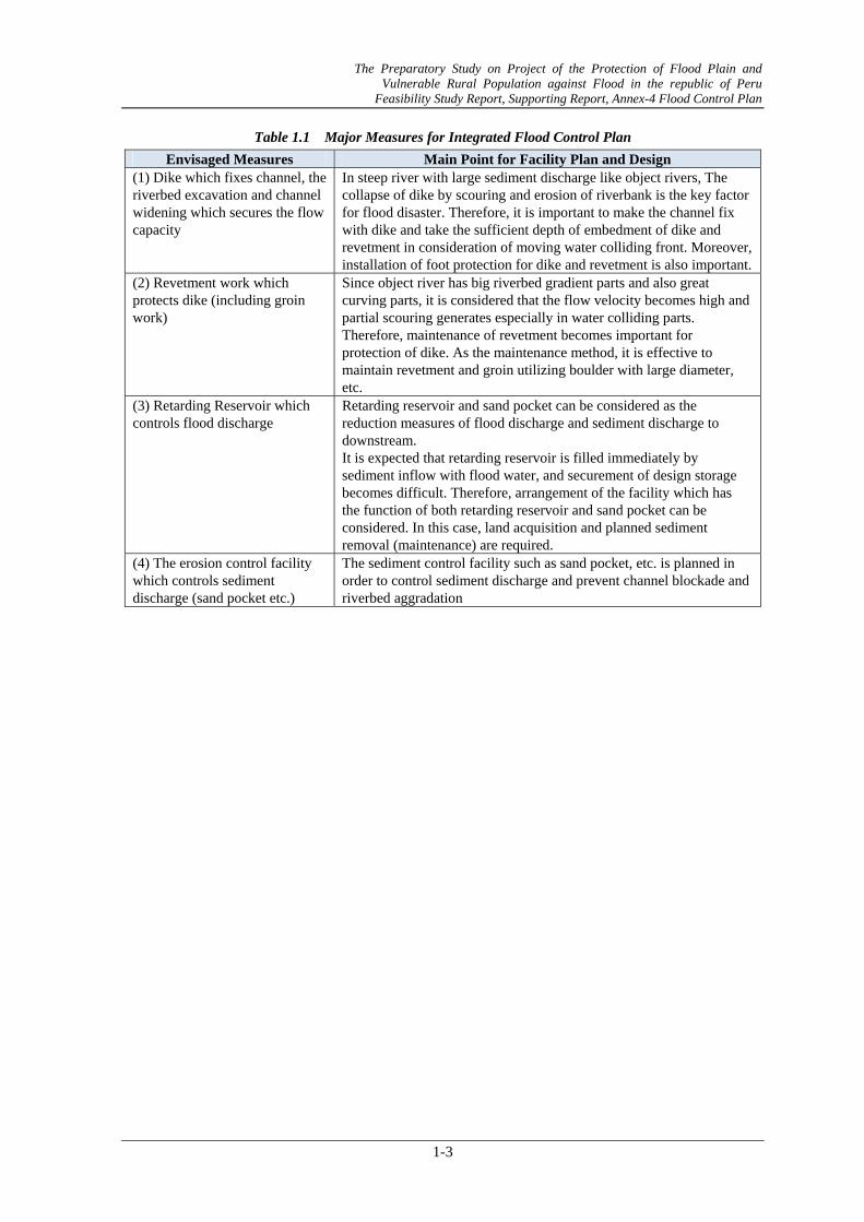
Table 1.1 Major Measures for Integrated Flood Control Plan
Envisaged Measures Main Point for Facility Plan and Design (1) Dike which fixes channel, the riverbed excavation and channel widening which secures the flow capacity
In steep river with large sediment discharge like object rivers, The collapse of dike by scouring and erosion of riverbank is the key factor for flood disaster. Therefore, it is important to make the channel fix with dike and take the sufficient depth of embedment of dike and revetment in consideration of moving water colliding front. Moreover, installation of foot protection for dike and revetment is also important.
(2) Revetment work which protects dike (including groin work)
Since object river has big riverbed gradient parts and also great curving parts, it is considered that the flow velocity becomes high and partial scouring generates especially in water colliding parts. Therefore, maintenance of revetment becomes important for protection of dike. As the maintenance method, it is effective to maintain revetment and groin utilizing boulder with large diameter, etc.
(3) Retarding Reservoir which controls flood discharge
Retarding reservoir and sand pocket can be considered as the reduction measures of flood discharge and sediment discharge to downstream. It is expected that retarding reservoir is filled immediately by sediment inflow with flood water, and securement of design storage becomes difficult. Therefore, arrangement of the facility which has the function of both retarding reservoir and sand pocket can be considered. In this case, land acquisition and planned sediment removal (maintenance) are required.
(4) The erosion control facility which controls sediment discharge (sand pocket etc.)
The sediment control facility such as sand pocket, etc. is planned in order to control sediment discharge and prevent channel blockade and riverbed aggradation
The Preparatory Study on Project of the Protection of Flood Plain and Vulnerable Rural Population against Flood in the republic of Peru
Feasibility Study Report, Supporting Report, Annex-4 Flood Control Plan
2-1
CHAPTER 2 CURRENT CHARACTERISTICS OF RIVERS
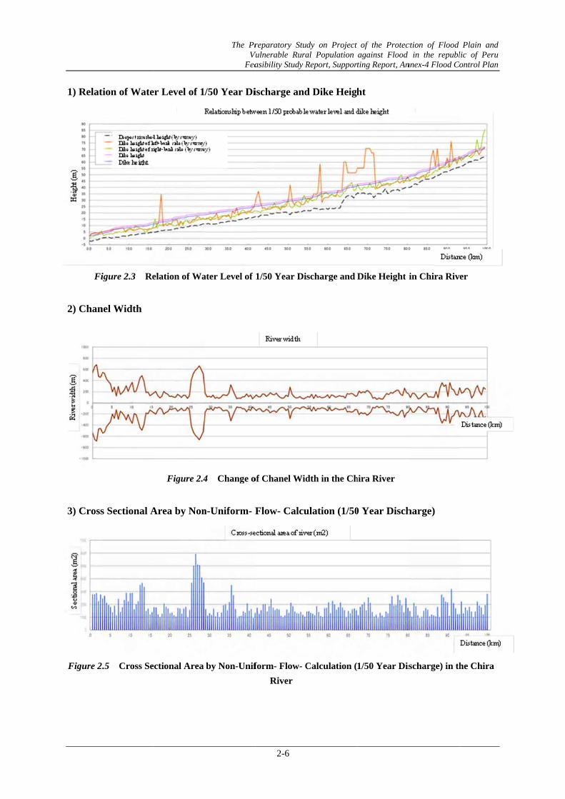
The channel characteristics of object 6 rivers are shown as follows. 2.1 Current Discharge Capacity
In order to grasp the current situation of channel characteristic, the discharge capacity was calculated based on longitudinal survey result for each river. The figure of discharge capacity for each river is shown as below. (Chira River, Canete River, Chincha River, Pisco River, Yauca River, Majes-Camana River)
Moreover, it is also shown collectively on the relationship between the required dike height and the present dike height for each river, and the channel width along the longitudinal profiles.
The Preparatory Study on Project of the Protection of Flood Plain and Vulnerable Rural Population against Flood in the republic of Peru
Feasibility Study Report, Supporting Report, Annex-4 Flood Control Plan
2-2
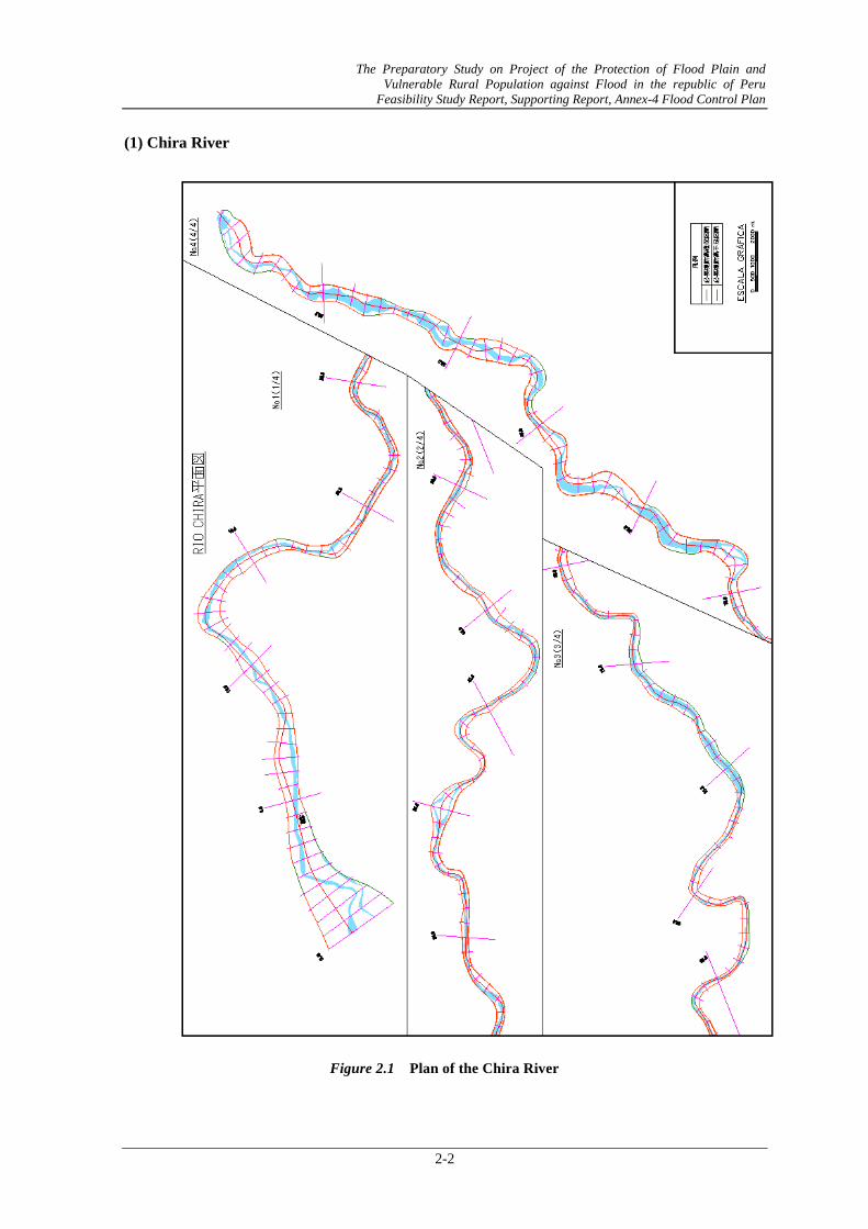
(1) Chira River
Figure 2.1 Plan of the Chira River
The Preparatory Study on Project of the Protection of Flood Plain and Vulnerable Rural Population against Flood in the republic of Peru
Feasibility Study Report, Supporting Report, Annex-4 Flood Control Plan
2-3
Table 2.1 Calculated Water Level and Required Dike Height
Classified by Probable Discharge Scale in the Chira River
Left-bank side Right-bank side 1/5 1/10 1/25 1/50 1/100 Left-bank side Right-bank side Left-bank side Right-bank side
DistanceActual dike height Calculated water level Actual dike height -HWL(1/50)
Dike height
■: Shortage of Present Dike Height: 1m or more to H.W.L (1/50). ■: Shortage of Present Dike Height: less than1m to H.W.L (1/50). ■: Shortage of Present Dike Height: 1m or more to Design Dike Height (H.W.L+1.2m) ■: Shortage of Present Dike Height: less than 1m to Design Dike Height (H.W.L+1.2m)
Figure
The
e 2.2 Discha
e Preparatory Vulnerable RFeasibility Stu
2-5
arge Capacity
Study on ProjRural Populatiudy Report, Sup
y in the Chira
ject of the Prion against Flpporting Report
a River
rotection of Flolood in the rept, Annex-4 Floo
ood Plain andpublic of Peru
od Control Plan
d u n
1) Relat
Fi
2) Chan
3) Cross
Figure 2.
tion of Wate
igure 2.3 Re
nel Width
s Sectional A
.5 Cross Se
er Level of 1
elation of Wa
Figure 2.4
Area by Non
ectional Area
The Pr Vu
Fea
/50 Year Di
ater Level of
4 Change o
n-Uniform- F
by Non-Unif
reparatory StuVulnerable Rura
asibility Study R
2-6
ischarge and
1/50 Year Di
of Chanel Wid
Flow- Calcu
form- Flow- CRiver
dy on Project al Population Report, Suppor
d Dike Heigh
scharge and
dth in the Ch
ulation (1/50
Calculation (
of the Protecagainst Flood ting Report, An
ht
Dike Height i
hira River
0 Year Disch
1/50 Year Dis
ction of Flood d in the republnnex-4 Flood Co
in Chira Riv
harge)
scharge) in th
Plain and lic of Peru ontrol Plan
er
he Chira
The Preparatory Study on Project of the Protection of Flood Plain and Vulnerable Rural Population against Flood in the republic of Peru
Feasibility Study Report, Supporting Report, Annex-4 Flood Control Plan
2-7
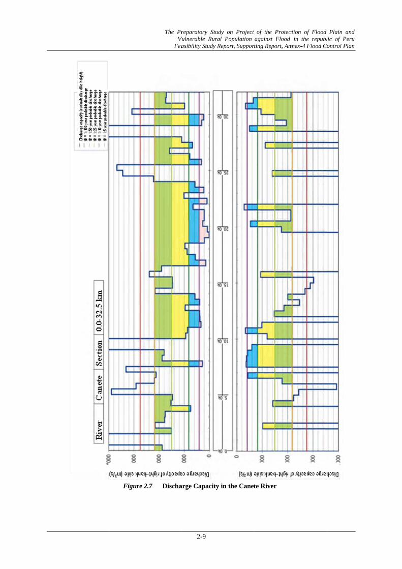
(2) Canete River
Figure 2.6 Plan of the Canete River
The Preparatory Study on Project of the Protection of Flood Plain and Vulnerable Rural Population against Flood in the republic of Peru
Feasibility Study Report, Supporting Report, Annex-4 Flood Control Plan
2-8
Table 2.2 Calculated Water Level and Required Dike Height
Classified by Probable Discharge Scale in the Canete River
Left-bank side Right-bank side 1/5 1/10 1/25 1/50 1/100 Left-bank side Right-bank side Left-bank side Right-bank side
CaneteActual dike height Actual dike height -HWL(1/50)
DistanceCalculated water level
■: Shortage of Present Dike Height: 1m or more to H.W.L (1/50). ■: Shortage of Present Dike Height: less than1m to H.W.L (1/50). ■: Shortage of Present Dike Height: 1m or more to Design Dike Height (H.W.L+1.2m)■: Shortage of Present Dike Height: less than 1m to Design Dike Height (H.W.L+1.2m)
Figure 2
The Pr Vu
Fea
2.7 Discha
reparatory StuVulnerable Rura
asibility Study R
2-9
arge Capacity
dy on Project al Population Report, Suppor
y in the Canet
of the Protecagainst Flood ting Report, An
te River
ction of Flood d in the republnnex-4 Flood Co
Plain and lic of Peru ontrol Plan
1) Relat
Fig
2) Chan
3) Cross
Figure
tion of Wate
gure 2.8 Re
nel Width
s Sectional A
e 2.10 Cros
er Level of 1
elation of Wa
Figure 2.9
Area by Non
ss Sectional A
The Pr Vu
Fea
/50 Year Di
ater Level of
Change o
n-Uniform- F
Area by Non-C
reparatory StuVulnerable Rura
asibility Study R
2-10
ischarge and
1/50 Year Di
of Chanel Wid
Flow- Calcu
-Uniform- FloCanete River
dy on Project al Population Report, Suppor
d Dike Heigh
scharge and
dth in the Ca
ulation (1/50
ow- Calculatir
of the Protecagainst Flood ting Report, An
ht
Dike Height i
anete River
0 Year Disch
ion (1/50 Yea
ction of Flood d in the republnnex-4 Flood Co
in Canete Ri
harge)
ar Discharge)
Plain and lic of Peru ontrol Plan
ver
) in the
The Preparatory Study on Project of the Protection of Flood Plain and Vulnerable Rural Population against Flood in the republic of Peru
Feasibility Study Report, Supporting Report, Annex-4 Flood Control Plan
2-11
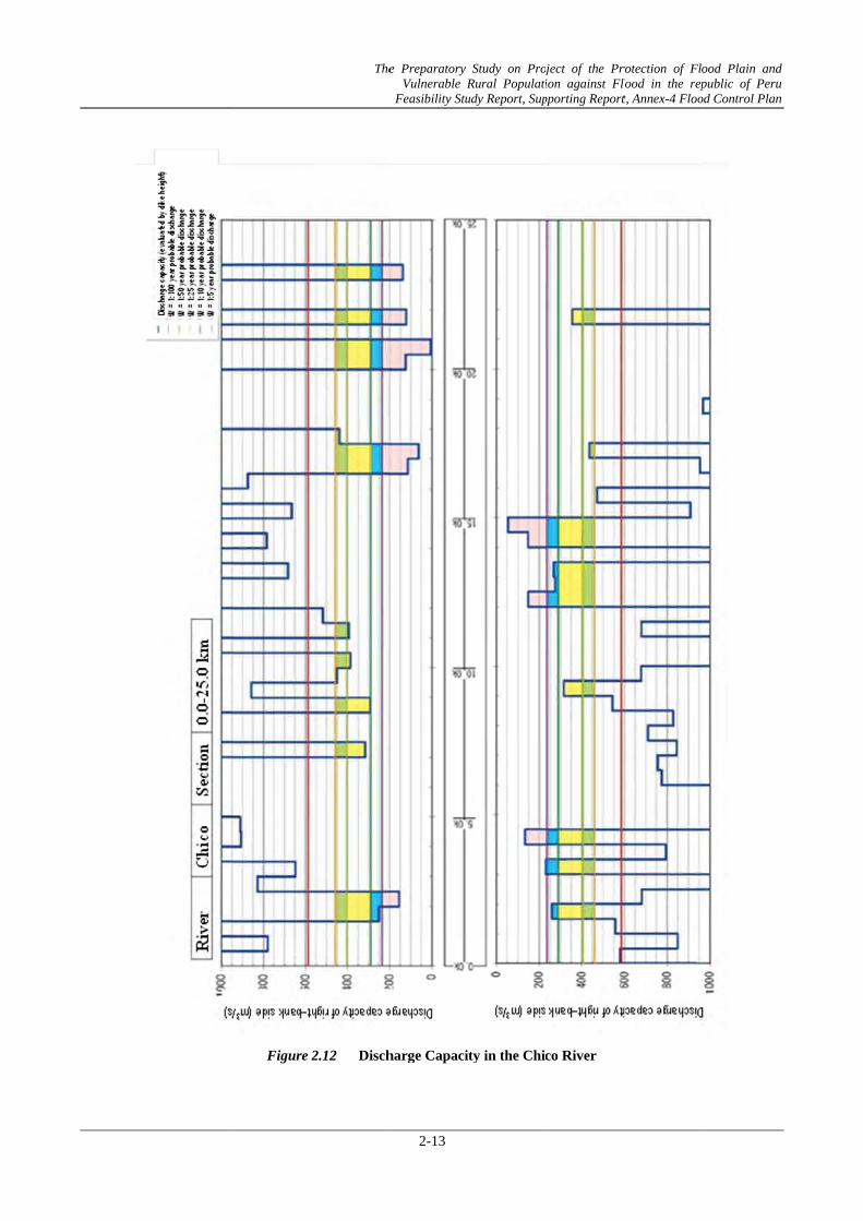
(3) Chincha River(Chico River,Matagente River)
Figure 2.11 Plan of the Chincha River
The Preparatory Study on Project of the Protection of Flood Plain and Vulnerable Rural Population against Flood in the republic of Peru
Feasibility Study Report, Supporting Report, Annex-4 Flood Control Plan
2-12
Table 2.3 Calculated Water Level and Required Dike Height Classified by Probable Discharge Scale in the Chico River
Left-bank side Right-bank side 1/5 1/10 1/25 1/50 1/100 Left-bank side Right-bank side Left-bank side Right-bank side
Actual dike height Actual dike height -HWL(1/50)Distance
Calculated water levelDike height
■: Shortage of Present Dike Height: 1m or more to H.W.L (1/50). ■: Shortage of Present Dike Height: less than1m to H.W.L (1/50). ■: Shortage of Present Dike Height: 1m or more to Design Dike Height (H.W.L+1.2m) ■: Shortage of Present Dike Height: less than 1m to Design Dike Height (H.W.L+1.2m)
Figure 2
The
2.12 Disch
e Preparatory Vulnerable RFeasibility Stu
2-13
harge Capaci
Study on ProjRural Populatiudy Report, Sup
ity in the Chic
ject of the Prion against Flpporting Report
co River
rotection of Flolood in the rept, Annex-4 Floo
ood Plain andpublic of Peru
od Control Plan
d u n
1) Relat
Fig
2) Chan
3) Cross
Figure
tion of Wate
gure 2.13 R
nge of Chane
s Sectional A
e 2.15 Cros
er Level of 1
Relation of W
el Width
Figure 2.14
Area by Non
ss Sectional A
The Pr Vu
Fea
/50 Year Di
Water Level of
4 Change
n-Uniform-F
Area by Non-
reparatory StuVulnerable Rura
asibility Study R
2-14
ischarge and
f 1/50 Year D
of Chanel W
Flow-Calcul
-Uniform- FloChico River
dy on Project al Population Report, Suppor
d Dike Heigh
Discharge and
Width in the C
lation (1/50 Y
ow- Calculati
of the Protecagainst Flood ting Report, An
ht
d Dike Height
hico River
Year Discha
ion (1/50 Yea
ction of Flood d in the republnnex-4 Flood Co
t in Chico Ri
arge)
ar Discharge)
Plain and lic of Peru ontrol Plan
ver
) in the
The Preparatory Study on Project of the Protection of Flood Plain and Vulnerable Rural Population against Flood in the republic of Peru
Feasibility Study Report, Supporting Report, Annex-4 Flood Control Plan
2-15
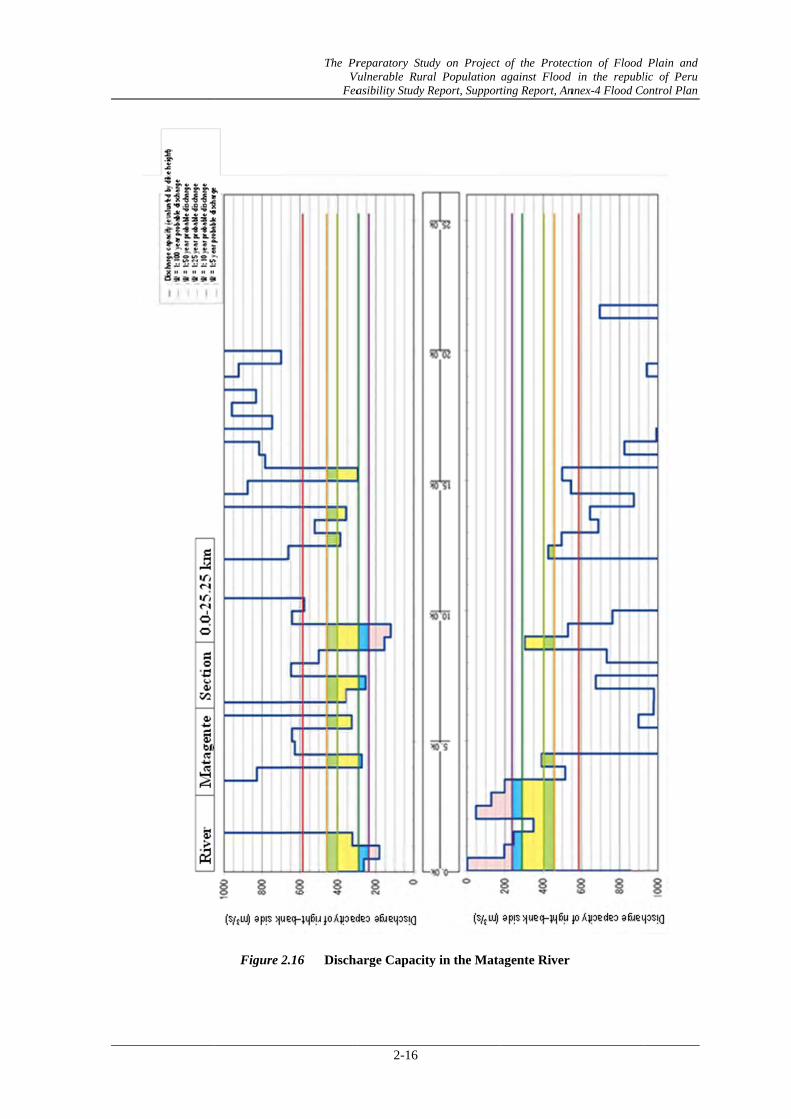
Table 2.4 Calculated Water Level and Required Dike Height Classified by Probable Discharge Scale in the Matagente River
Left-bank side Right-bank side 1/5 1/10 1/25 1/50 1/100 Left-bank side Right-bank side Left-bank side Right-bank side
MatagenteActual dike height Actual dike height -HWL(1/50)
DistanceCalculated water level
■: Shortage of Present Dike Height: 1m or more to H.W.L (1/50). ■: Shortage of Present Dike Height: less than1m to H.W.L (1/50). ■: Shortage of Present Dike Height: 1m or more to Design Dike Height (H.W.L+1.2m) ■: Shortage of Present Dike Height: less than 1m to Design Dike Height (H.W.L+1.2m)
Figure 2
The Pr Vu
Fea
2.16 Discha
reparatory StuVulnerable Rura
asibility Study R
2-16
arge Capacit
dy on Project al Population Report, Suppor
ty in the Mata
of the Protecagainst Flood ting Report, An
agente River
ction of Flood d in the republnnex-4 Flood C
Plain and lic of Peru ontrol Plan
1) Re
Fig
2) Ch
3) Cr
Figu
elation of W
ure 2.17 R
hanel Width
ross Section
ure 2.19 Cr
Water Level o
Relation of W
h
Figure 2.18
al Area by N
ross Sectiona
The Pr Vu
Fea
of 1/50 Year
Water Level of
8 Change o
Non-Uniform
al Area by NoM
reparatory StuVulnerable Rura
asibility Study R
2-17
r Discharge
f 1/50 Year D
of Chanel Wi
m-Flow-Cal
on-Uniform- FMatagente R
dy on Project al Population Report, Suppor
and Dike H
Discharge and
idth in the M
lculation (1/
Flow- CalculRiver
of the Protecagainst Flood ting Report, An
eight
d Dike Height
Matagente Riv
50 Year Dis
ation (1/50 Y
ction of Flood d in the republnnex-4 Flood C
t in Matagent
ver
scharge)
Year Discharg
Plain and lic of Peru ontrol Plan
te River
ge) in the
The Preparatory Study on Project of the Protection of Flood Plain and Vulnerable Rural Population against Flood in the republic of Peru
Feasibility Study Report, Supporting Report, Annex-4 Flood Control Plan
2-18
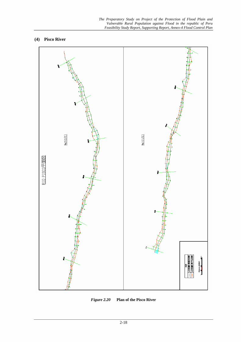
(4) Pisco River
Figure 2.20 Plan of the Pisco River
The Preparatory Study on Project of the Protection of Flood Plain and Vulnerable Rural Population against Flood in the republic of Peru
Feasibility Study Report, Supporting Report, Annex-4 Flood Control Plan
2-19
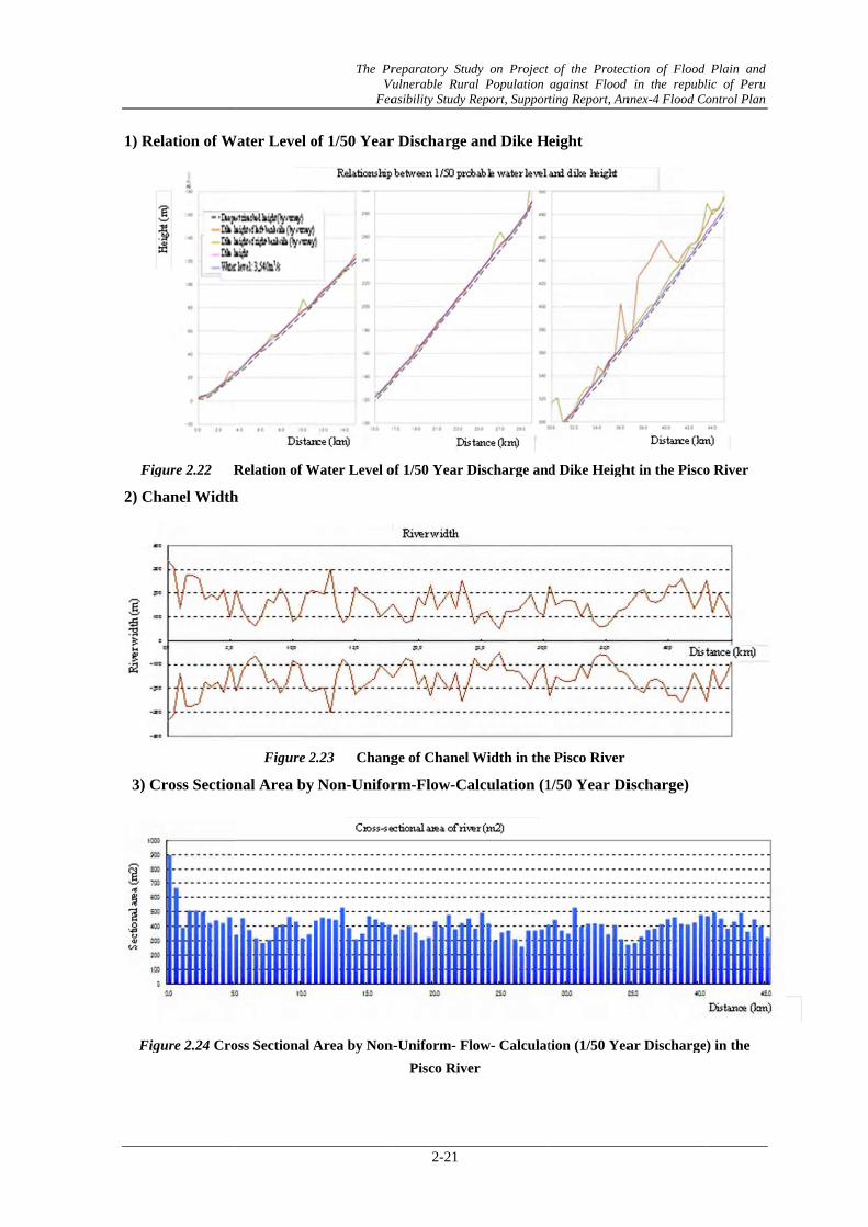
Table 2.5 Calculated Water Level and Required Dike Height Classified by Probable Discharge Scale in the Pisco River
Left-bank side Right-bank side 1/5 1/10 1/25 1/50 1/100 Left-bank side Right-bank side Left-bank side Right-bank side
Actual dike height Actual dike height -HWL(1/50)Distance
Calculated water levelDike height
■: Shortage of Present Dike Height: 1m or more to H.W.L (1/50). ■: Shortage of Present Dike Height: less than1m to H.W.L (1/50). ■: Shortage of Present Dike Height: 1m or more to Design Dike Height (H.W.L+1.2m) ■: Shortage of Present Dike Height: less than 1m to Design Dike Height (H.W.L+1.2m)
Figur
The Pr Vu
Fea
re 2.21 Dis
reparatory StuVulnerable Rura
asibility Study R
2-20
scharge Capa
dy on Project al Population Report, Suppor
acity in the Pi
of the Protecagainst Flood ting Report, An
isco River
ction of Flood d in the republnnex-4 Flood C
Plain and lic of Peru ontrol Plan
1) Re
Fig
2) Ch
3) C
Fig
elation of W
gure 2.22 R
hanel Width
Cross Section
gure 2.24 Cro
Water Level o
Relation of W
h
Figure 2
nal Area by
oss Sectional A
The Pr Vu
Fea
of 1/50 Year
Water Level o
2.23 Chang
Non-Unifor
Area by Non
reparatory StuVulnerable Rura
asibility Study R
2-21
r Discharge
of 1/50 Year D
ge of Chanel
rm-Flow-Ca
n-Uniform- FlPisco Rive
dy on Project al Population Report, Suppor
and Dike H
Discharge and
Width in the
alculation (1
low- Calculater
of the Protecagainst Flood ting Report, An
eight
d Dike Heigh
e Pisco River
1/50 Year Di
tion (1/50 Yea
ction of Flood d in the republnnex-4 Flood C
ht in the Pisco
ischarge)
ar Discharge
Plain and lic of Peru ontrol Plan
o River
) in the
The Preparatory Study on Project of the Protection of Flood Plain and Vulnerable Rural Population against Flood in the republic of Peru
Feasibility Study Report, Supporting Report, Annex-4 Flood Control Plan
2-22
(5) Yauca River
Figure 2.25 Plan of the Yauva River
The Preparatory Study on Project of the Protection of Flood Plain and Vulnerable Rural Population against Flood in the republic of Peru
Feasibility Study Report, Supporting Report, Annex-4 Flood Control Plan
2-23
Table 2.6 Calculated Water Level and Required Dike Height Classified by Probable Discharge Scale in the Yauca River
Left-bank side Right-bank side 1/5 1/10 1/25 1/50 1/100 Left-bank side Right-bank side Left-bank side Right-bank side
YaucaActual dike height Actual dike height -HWL(1/50)
DistanceCalculated water level
■: Shortage of Present Dike Height: 1m or more to H.W.L (1/50). ■: Shortage of Present Dike Height: less than1m to H.W.L (1/50). ■: Shortage of Present Dike Height: 1m or more to Design Dike Height (H.W.L+1.2m)■: Shortage of Present Dike Height: less than 1m to Design Dike Height (H.W.L+1.2m)
Figure 2
The Pr Vu
Fea
2.26 Discha
reparatory StuVulnerable Rura
asibility Study R
2-24
arge Capacit
dy on Project al Population Report, Suppor
ty in the Yauc
of the Protecagainst Flood ting Report, An
ca River
ction of Flood d in the republnnex-4 Flood Co
Plain and lic of Peru ontrol Plan
1) Re
Figu
2) Ch
3) CY
Figu
elation of W
ure 2.27 R
hanel Width
ross Sectionauca River
ure 2.29 Cr
Water Level o
elation of Wa
h
Figure 2.2
nal Area b
ross Sectiona
The Pr Vu
Fea
of 1/50 Year
ater Level of
28 Change
y Non-Unif
al Area by Not
reparatory StuVulnerable Rura
asibility Study R
2-25
r Discharge
1/50 Year Di
e of Chanel W
form-Flow-C
on-Uniform- Fthe Yauca Riv
dy on Project al Population Report, Suppor
and Dike H
ischarge and
Width in the Y
Calculation
Flow- Calculver
of the Protecagainst Flood ting Report, An
eight
Dike Height
Yauca River
(1/50 Year
ation (1/50 Y
ction of Flood d in the republnnex-4 Flood C
in the Yauca
r Discharge
Year Discharg
Plain and lic of Peru ontrol Plan
a River
e)in the
ge) in
(6) MMajes- Camaana River
Figu
The Pr Vu
Fea
ure 2.30 Pl
reparatory StuVulnerable Rura
asibility Study R
2-26
lan of the Ma
dy on Project al Population Report, Suppor
ajes-Camana
of the Protecagainst Flood ting Report, An
River
ction of Flood d in the republnnex-4 Flood C
Plain and lic of Peru ontrol Plan
The Preparatory Study on Project of the Protection of Flood Plain and Vulnerable Rural Population against Flood in the republic of Peru
Feasibility Study Report, Supporting Report, Annex-4 Flood Control Plan
2-27
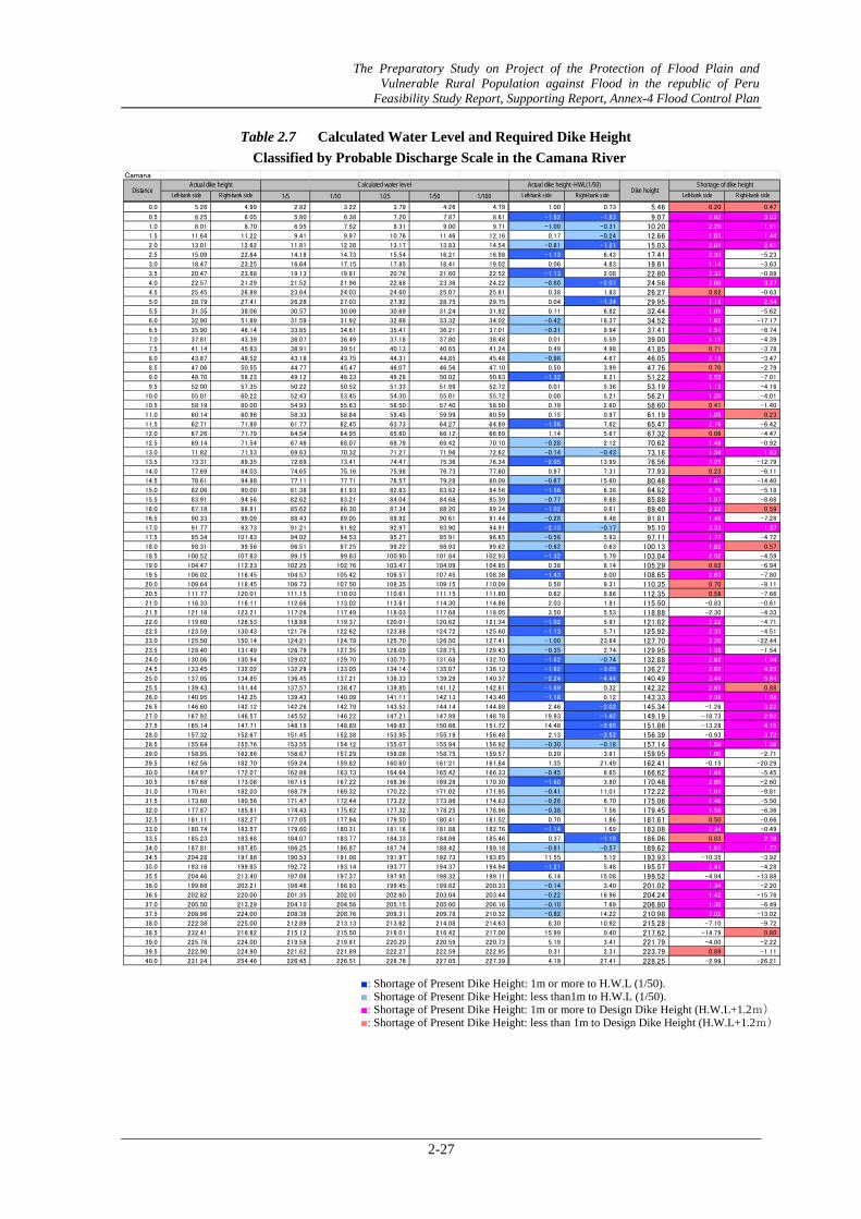
Table 2.7 Calculated Water Level and Required Dike Height Classified by Probable Discharge Scale in the Camana River
Left-bank side Right-bank side 1/5 1/10 1/25 1/50 1/100 Left-bank side Right-bank side Left-bank side Right-bank side
Actual dike height -HWL(1/50) Shortage of dike heightDike height
Camana
DistanceActual dike height Calculated water level
■: Shortage of Present Dike Height: 1m or more to H.W.L (1/50). ■: Shortage of Present Dike Height: less than1m to H.W.L (1/50). ■: Shortage of Present Dike Height: 1m or more to Design Dike Height (H.W.L+1.2m) ■: Shortage of Present Dike Height: less than 1m to Design Dike Height (H.W.L+1.2m)
Figure 2
The Pr Vu
Fea
2.31 Disch
reparatory StuVulnerable Rura
asibility Study R
2-28
harge Capacit
dy on Project al Population Report, Suppor
ty in the Cam
of the Protecagainst Flood ting Report, An
mana River
ction of Flood d in the republnnex-4 Flood C
Plain and lic of Peru ontrol Plan
1) Re
Figur
2) Ch
3) Cr
Figur
elation of W
re-2.32 Re
hanel Width
ross Section
re 2.34 Cro
Water Level o
elation of Wat
h
Figure 2.33
al Area by N
oss Sectional
The Pr Vu
Fea
of 1/50 Year
ter Level of 1
3 Change
Non-Uniform
Area by Non
reparatory StuVulnerable Rura
asibility Study R
2-29
r Discharge
1/50 Year Dis
of Chanel W
m-Flow-Cal
n-Uniform- FCamana Riv
dy on Project al Population Report, Suppor
and Dike H
scharge and D
Width in the C
lculation (1/
Flow- Calculaver
of the Protecagainst Flood ting Report, An
eight
Dike Height i
amana River
50 Year Dis
ation (1/50 Ye
ction of Flood d in the republnnex-4 Flood C
in the Caman
r
scharge)
ear Discharge
Plain and lic of Peru ontrol Plan
na River
e) in the
The Preparatory Study on Project of the Protection of Flood Plain and Vulnerable Rural Population against Flood in the republic of Peru
Feasibility Study Report, Supporting Report, Annex-4 Flood Control Plan
2-30
Table 2.8 Calculated Water Level and Necessary Dike Height at the Time of River Flow with Probable Discharge Scale in the Majes River
Left-bank side Right-bank side 1/5 1/10 1/25 1/50 1/100 Left-bank side Right-bank side Left-bank side Right-bank side
DistanceActual dike height Calculated water level Actual dike height -HWL(1/50)
Dike height
■: Shortage of Present Dike Height: 1m or more to H.W.L (1/50). ■: Shortage of Present Dike Height: less than1m to H.W.L (1/50). ■: Shortage of Present Dike Height: 1m or more to Design Dike Height (H.W.L+1.2m) ■: Shortage of Present Dike Height: less than 1m to Design Dike Height (H.W.L+1.2m)
Figure
The Pr Vu
Fea
e 2.35 Disc
reparatory StuVulnerable Rura
asibility Study R
2-32
charge Capac
dy on Project al Population Report, Suppor
city in the M
of the Protecagainst Flood ting Report, An
ajes River
ction of Flood d in the republnnex-4 Flood C
Plain and lic of Peru ontrol Plan
1) Re
Fig
2) Ch
3) Cr
Figu
elation of W
gure 2.36 R
hanel Width
ross Section
ure 2.38 Cr
Water Level o
Relation of W
h
Figure 2.
al Area by N
ross Sectiona
The Pr Vu
Fea
of 1/50 Year
Water Level of
.37 Chang
Non-Uniform
al Area by No
reparatory StuVulnerable Rura
asibility Study R
2-33
r Discharge
f 1/50 Year D
ge of Chanel W
m-Flow-Cal
on-Uniform- F
Majes Riv
dy on Project al Population Report, Suppor
and Dike H
Discharge and
Width in the
lculation (1/
Flow- Calcul
er
of the Protecagainst Flood ting Report, An
eight
d Dike Height
Majes River
50 Year Dis
ation (1/50 Y
ction of Flood d in the republnnex-4 Flood C
t in the Maje
r
scharge)
Year Discharg
Plain and lic of Peru ontrol Plan
es River
ge) in the
The Preparatory Study on Project of the Protection of Flood Plain and Vulnerable Rural Population against Flood in the republic of Peru
Feasibility Study Report, Supporting Report, Annex-4 Flood Control Plan
2-34
2.2 Inundation Characteristic
Inundation analysis (1/50 year probable flood scale) for each river was carried out, the flood characteristics arranged are shown in the following tables. Moreover, the flood analysis outputs are shown from the next page.
Table 2.9 Flood Characteristics for Each River
River name Flood characteristics
Chira River Since the discharge capacity is insufficient in the whole, it overflows at all the points and flood flow spreads in the low flat plain along the river.
Canete River In the upstream area from 10km (distance mark) from the river mouth, although it overflows due to the shortage of discharge capacity, it remains in the influence of the farmland on the circumference of the channel. However, in downstream area from 10km from the river mouth, the flood flow spreads greatly just in the right-bank side, and the damage becomes large.
Chincha River
Chico At the vicinities of 15km and 4km from the river mouth, overflows occur, and flood flows spread greatly in the left-bank side.
Matagente At the vicinities of 10km and 4km from the river mouth, overflows occur, and flood flows spread greatly in the right-bank side.
Pisco River In the upstream area from 7km from the river mouth, although it overflows around the channel by the shortage of discharge capacity, the flood flow does not spread widely. However, if it overflows in the downstream area from 7km, the flood flow will spread greatly in the left-bank side, and serious damage will be occurred in the Pisco City.
Yauca River It overflows in downstream part from the vicinity of 7km from the river mouth, and the flood flow spreads in the farmland of the right-bank side.
Majes- Camana River It overflows at the vicinity of 5km from the river mouth, and the flood flow spreads greatly in the left-bank side. In middle stream and upstream areas, It overflows in lowland plain, and flood flow stagnates by the surrounded hills and mountains.
The Preparatory Study on Project of the Protection of Flood Plain and Vulnerable Rural Population against Flood in the republic of Peru
Feasibility Study Report, Supporting Report, Annex-4 Flood Control Plan
2-35
Figure 2.39 Result of Flood Analysis in the Chira River (1/50 Year Probable Flood)
The Preparatory Study on Project of the Protection of Flood Plain and Vulnerable Rural Population against Flood in the republic of Peru
Feasibility Study Report, Supporting Report, Annex-4 Flood Control Plan
2-36
Figure 2.40 Result of Flood Analysis in the Canete River (1/50 Year Probable Flood)
The Preparatory Study on Project of the Protection of Flood Plain and Vulnerable Rural Population against Flood in the republic of Peru
Feasibility Study Report, Supporting Report, Annex-4 Flood Control Plan
2-37
Figure 2.41 Result of Flood Analysis in the Chico River (1/50 Year Probable Flood)
The Preparatory Study on Project of the Protection of Flood Plain and Vulnerable Rural Population against Flood in the republic of Peru
Feasibility Study Report, Supporting Report, Annex-4 Flood Control Plan
2-38
Figure 2.42 Result of Flood Analysis in the Matagente River (1/50 Year Probable Flood)
The Preparatory Study on Project of the Protection of Flood Plain and Vulnerable Rural Population against Flood in the republic of Peru
Feasibility Study Report, Supporting Report, Annex-4 Flood Control Plan
2-39
Figure 2.43 Result of Flood Analysis in the Pisco River (1/50 Year Probable Flood)
The Preparatory Study on Project of the Protection of Flood Plain and Vulnerable Rural Population against Flood in the republic of Peru
Feasibility Study Report, Supporting Report, Annex-4 Flood Control Plan
2-40
Figure 2.44 Result of Flood Analysis in the Yauca River (1/50 Year Probable Flood)
The Preparatory Study on Project of the Protection of Flood Plain and Vulnerable Rural Population against Flood in the republic of Peru
Feasibility Study Report, Supporting Report, Annex-4 Flood Control Plan
2-41
Figure 2.45 Result of Flood Analysis in the Majes-Canama River (1/50 Year Probable Flood)
The Preparatory Study on Project of the Protection of Flood Plain and Vulnerable Rural Population against Flood in the republic of Peru
Feasibility Study Report, Supporting Report, Annex-4 Flood Control Plan
2-42
2.3 Riverbed-Fluctuation Characteristic
The results of riverbed fluctuation analysis are arranged as follows. River name Riverbed-fluctuation characteristics
Chira River Since the outflow of sediment is intercepted by the Poechos dam in the Chira river, the degradation of riverbed is remarkable in the just downstream of the dam.
On the other hand, in the Sullana Weir located in the middle stream part, since the sediment moving from the upstream channel and tributaries accumulates, and then the riverbed aggrades.
In case of carrying out no maintenance for sediment excavation, the discharge capacity will be insufficient in the future.
Large riverbed fluctuation does not produce fundamentally in most of sections in the downstream area.
The riverbed degradation occurs at several sections immediately after large-scale flood.
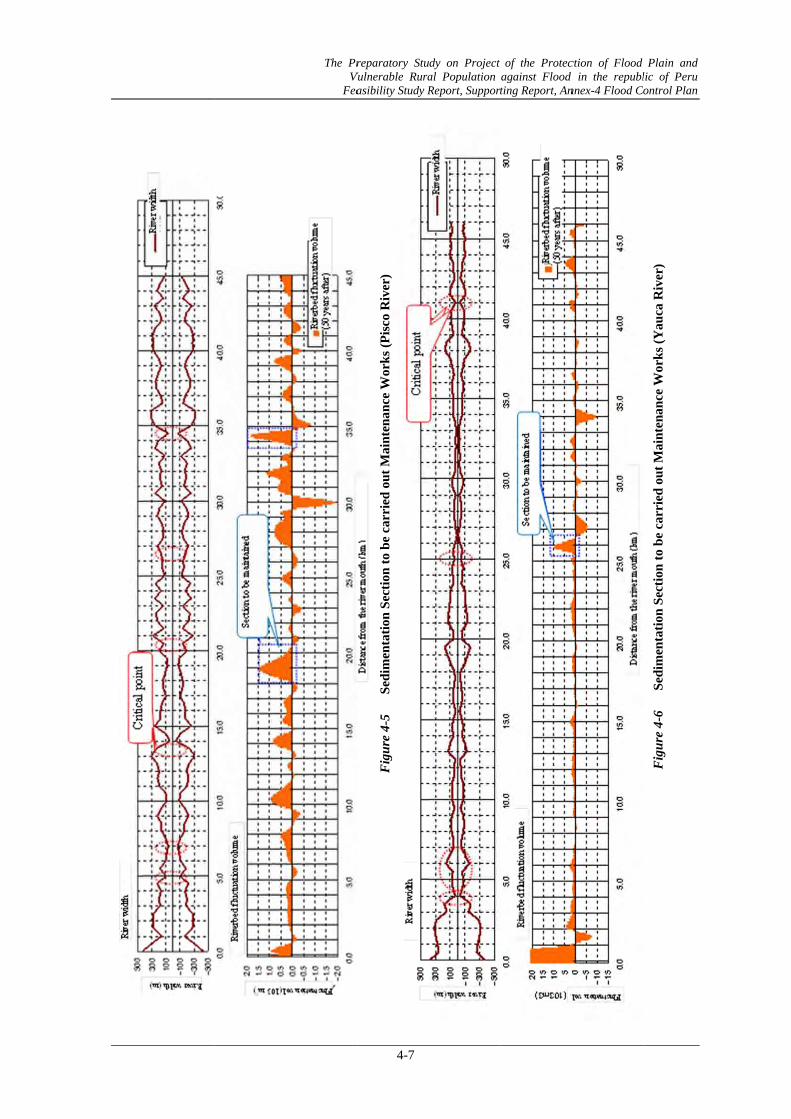
Canete River The average riverbed aggradation is calculated about 20cm in average in the Canete River in case of 50 years for the future.
However, since the channel width is narrow in 28-30km (distance mark) section in the upstream, the riverbed aggradation with 1-2m occurs locally.
The periodical excavation (maintenance) is required in this section. Also at the just downstream point (4km) of Ca-1 and Ca-2 which show critical
points, the riverbed aggradation with about 1m may arise at the maximum. Continuous monitoring is required in order to grasp the influence of the sediment discharge capacity at the implementation sections of measures.
Chincha River In the Chincha River, when the diversion Weir is repaired and the flow rate and sediment discharge can be allocated to 1:1 in the future, the riverbed aggradation of the average of 20 -30 cm produces in case of 50 years later.
On the other hand, when the diversion weir has not been repaired, and if the flow rate and sediment discharge incline toward either, the riverbed aggradation in case of 50 years becomes more twice compared with the repaired case. Through the comparison on “with improvement” and without improvement” for weir, the riverbed aggradation control effect by improvement of the diversion weir can be checked.
Taking into account the critical points and the riverbed fluctuation tendency, sediment accumulates in the section just downstream of C-1 and C-2 points of the Chico River, and the risk of the flood occurrences is high in the upstream.
On the other hand, sediment deposition has occurred at M-3 and M-4 points in the Matagente River, and the risk of flood occurrences is also high.
As for the measures on sedimentation, periodical excavation (maintenance) is required.
Rio Pisco The riverbed aggradation with 20 cm in average will be assumed in the Pisco River in case of 50 years after.
Aggradation rate is relatively small in average, however, the section just upstream the narrow areas with about 1m has possibility for aggradation, and the inundation risk is high.
In those narrow sections, periodical excavation for maintenance is required. Yauca River The riverbed aggradation with 10cm in average will be expected in the Yauca
River in case of 50 years after. Although riverbed fluctuation will occur partially in the river mouth section
and the upstream section, the riverbed will show a stable inclination on the whole.
This main reason on stable condition is due to low river discharge to carry sediment.
Although sediment deposition will occur in the most downstream section, since there are no critical places in the part, even if it will deposit, for the
The Preparatory Study on Project of the Protection of Flood Plain and Vulnerable Rural Population against Flood in the republic of Peru
Feasibility Study Report, Supporting Report, Annex-4 Flood Control Plan
2-43
moment, adverse problems will not occur. Majes - Camana River
The riverbed aggradation with 20cm in average will be predicted in the Majes-Camana River in case of 50 years after.
Although there is low possibility that adverse problems will arise on flood control, in the vicinities of 13km and 101km distance mark, the riverbed aggradation with 0.8m and 1m will be predicted, respectively.
It is analyzed that sedimentation will occur in the channel section which just downstream of the narrow section near 13km distance mark causing by expansion to the upstream. There is a diversion weir at 12.8km distance mark and trouble for taking water may arise, and excavation for maintenance in the river will be required.
Moreover, the 101km mark is a wide channel section which just downstream of narrow section, and also overflowed point in the past, excavation for maintenance is required from the viewpoint on flood control.
The riverbed aggradation is seen in the sections other than the above-mentioned section at 13km and 101km mark. It is not serious situation, the necessity of excavation for maintenance is low.
In the Majes-Camana River, the sections of the excavation for maintenance are the vicinities of 13km and 101km points, from the viewpoint of flood control and water use such as irrigation.
The Preparatory Study on Project of the Protection of Flood Plain and Vulnerable Rural Population against Flood in the republic of Peru
Feasibility Study Report, Supporting Report, Annex-4 Flood Control Plan
2-44
2.4 Local Scouring for Each River
The local scouring sections (Erosion) for each river are arranged based on the field reconnaissance result and the survey result. In the future, the measures against local scouring sections also become an important subject.
Table 2.10 Main Partial Scour (Erosion) Parts in the Object Rivers
Object river Erosion Sections Erosion situation
Chira River ① 11.5 km~12.5 km Right
Bank
Bank erosion has advanced, and the possibility that erosion
will reach the road along the right bank is high.
② 73 km Right Bank Damage of farmland with 5km by bank erosion
③ 98 km Right Bank Bank erosion has advanced, and the agricultural channel
along the right bank may suffer damage.
④ 99.5 km By the influence of dam discharge, the riverbank of
downstream of the dam has suffered damage by erosion.
Canete River ① 7.5 km Right Bank Bank collapsed by local scouring at the time of the flood
occurred five years ago, and flood flow overflowed.
② 24 km~25 km Right
Bank
Bank erosion has advanced, and possibility that damage
will reach the road along the right bank is high.
Chincha River Remarkable erosion part was not identified.
Pisco River Remarkable erosion part was not identified.
Yauca River ① 7.0 km Right Bank Farmland along riverbank has suffered the damage of washing away by floods.
Majes-Camana
River
① 12 km~13 km Left Bank Damage may reach the urban water supply waterway constructed along the riverbank.
② 26 km The circumference of the bridge piers has eroded several meters by the flood of one year ago, and may suffer damage from now on.
③ 55 km~56.5 km Left
Bank
Farmland suffers damage by erosion caused by flood water every year.
④ 84.5 km Right Bank Bank erosion has advanced gradually every year. In case that the erosion is expanded downstream, the influence may reach the bridge located in the downstream.
⑤ 88.5 km Right Bank Caused by the flood in February, 2011, large-scale bank erosion arose and parts of houses were washed away.
The Preparatory Study on Project of the Protection of Flood Plain and Vulnerable Rural Population against Flood in the republic of Peru
Feasibility Study Report, Supporting Report, Annex-4 Flood Control Plan
3-1
CHAPTER 3 RIVER CHANNEL PLAN
Based on the discharge capacity and the characteristics on floods, etc. for each object river, the optimal river channel plan is formulated.
The probability for channel plan for each river is set at 1/50 years, and the river channel plans not only from the point of long-term aspect but also from strategic and urgent aspect are formulated.
3.1 Design for Alignment of Dike
The alignment of dike was designed based on the present status of dike. The river width was designed fundamentally as wide as possible. 3.2 Design for Cross Section of River
The longitudinal profiles and typical cross sections (river channel cross section) for each river were planned based on the securing of the discharge capacity and the alignment of plan.
3.3 Design for High Water Level
The examinations of design for high water level (H.W.L) and alignment of dike for the design high water discharge (1/50 year scale) for each river are carried out, and the dimensions of facilities are determined.
Design of high water level is set as the height which can flow down safely in the case of the discharge of design probable scale (1/50 year), and the dike height is set by applying design criteria on rivers in Japan as mentioned below.
The Preparatory Study on Project of the Protection of Flood Plain and Vulnerable Rural Population against Flood in the republic of Peru
Feasibility Study Report, Supporting Report, Annex-4 Flood Control Plan
3-2
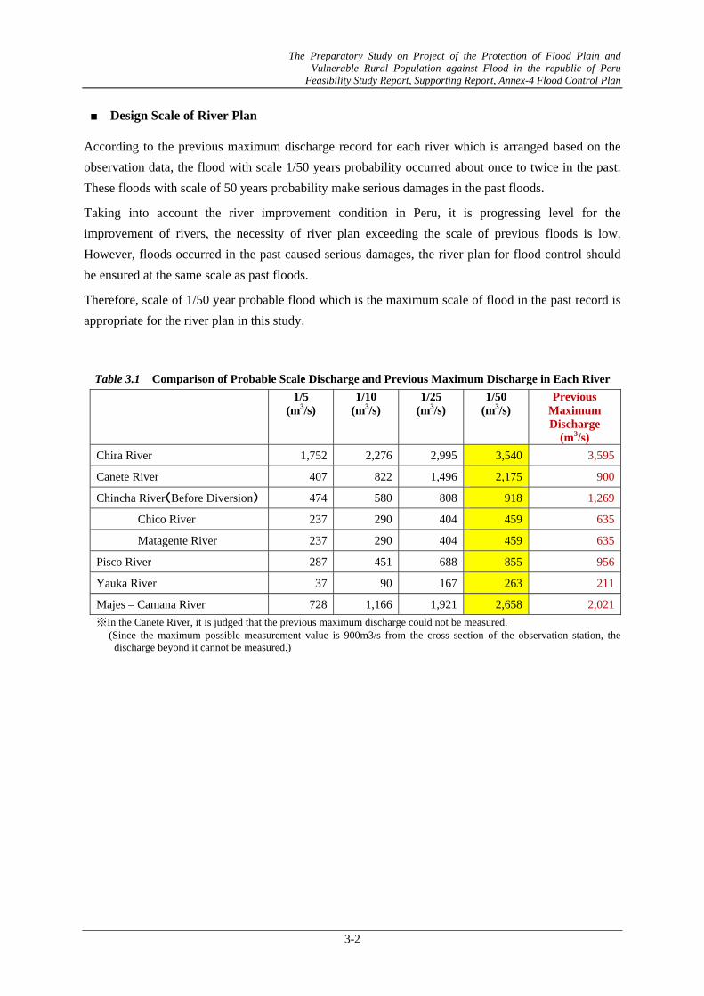
■ Design Scale of River Plan
According to the previous maximum discharge record for each river which is arranged based on the observation data, the flood with scale 1/50 years probability occurred about once to twice in the past. These floods with scale of 50 years probability make serious damages in the past floods.
Taking into account the river improvement condition in Peru, it is progressing level for the improvement of rivers, the necessity of river plan exceeding the scale of previous floods is low. However, floods occurred in the past caused serious damages, the river plan for flood control should be ensured at the same scale as past floods.
Therefore, scale of 1/50 year probable flood which is the maximum scale of flood in the past record is appropriate for the river plan in this study.
Table 3.1 Comparison of Probable Scale Discharge and Previous Maximum Discharge in Each River
Majes – Camana River 728 1,166 1,921 2,658 2,021※In the Canete River, it is judged that the previous maximum discharge could not be measured.
(Since the maximum possible measurement value is 900m3/s from the cross section of the observation station, the discharge beyond it cannot be measured.)
Figure 3.1
Figure 3.2
Annual Ma
Annual Ma
Figure 3.3
Figure 3.4
The Pr Vu
Fea
aximum Disc
aximum Disch
3 Annual M
Annual M
reparatory StuVulnerable Rura
asibility Study R
3-3
charge (Inflow
harge (Outflo
Maximum Di
Maximum Dis
dy on Project al Population Report, Suppor
w of Poechos
ow of Poechos
ischarge (Can
scharge (Chin
of the Protecagainst Flood ting Report, An
Dam in the C
s Dam in the
nete River)
ncha River)
ction of Flood d in the republnnex-4 Flood Co
Chira River)
Chira River)
Plain and lic of Peru ontrol Plan
)
F
Figure 3.
Figure 3.6
Figure 3.7 A
The Pr Vu
Fea
5 Annual
6 Annual M
Annual Maxi
reparatory StuVulnerable Rura
asibility Study R
3-4
Maximum D
Maximum Di
imum Discha
dy on Project al Population Report, Suppor
Discharge (Pis
ischarge (Yau
arge (Majes-C
of the Protecagainst Flood ting Report, An
sco River)
uca River)
Camana Rive
ction of Flood d in the republnnex-4 Flood Co
er)
Plain and lic of Peru ontrol Plan
The Preparatory Study on Project of the Protection of Flood Plain and Vulnerable Rural Population against Flood in the republic of Peru
Feasibility Study Report, Supporting Report, Annex-4 Flood Control Plan
3-5
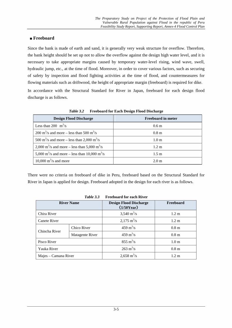
■ Freeboard
Since the bank is made of earth and sand, it is generally very weak structure for overflow. Therefore, the bank height should be set up not to allow the overflow against the design high water level, and it is necessary to take appropriate margins caused by temporary water-level rising, wind wave, swell, hydraulic jump, etc., at the time of flood. Moreover, in order to cover various factors, such as securing of safety by inspection and flood fighting activities at the time of flood, and countermeasures for flowing materials such as driftwood, the height of appropriate margin (freeboard) is required for dike.
In accordance with the Structural Standard for River in Japan, freeboard for each design flood discharge is as follows.
Table 3.2 Freeboard for Each Design Flood Discharge
Design Flood Discharge Freeboard in meter
Less than 200 m3/s 0.6 m
200 m3/s and more – less than 500 m3/s 0.8 m
500 m3/s and more – less than 2,000 m3/s 1.0 m
2,000 m3/s and more – less than 5,000 m3/s 1.2 m
5,000 m3/s and more – less than 10,000 m3/s 1.5 m
10,000 m3/s and more 2.0 m
There were no criteria on freeboard of dike in Peru, freeboard based on the Structural Standard for River in Japan is applied for design. Freeboard adopted in the design for each river is as follows.
Table 3.3 Freeboard for each River
River Name Design Flood Discharge (1/50Year)
Freeboard
Chira River 3,540 m3/s 1.2 m
Canete River 2,175 m3/s 1.2 m
Chincha River Chico River 459 m3/s 0.8 m
Matagente River 459 m3/s 0.8 m
Pisco River 855 m3/s 1.0 m
Yauka River 263 m3/s 0.8 m
Majes – Camana River 2,658 m3/s 1.2 m
The Preparatory Study on Project of the Protection of Flood Plain and Vulnerable Rural Population against Flood in the republic of Peru
Feasibility Study Report, Supporting Report, Annex-4 Flood Control Plan
3-6
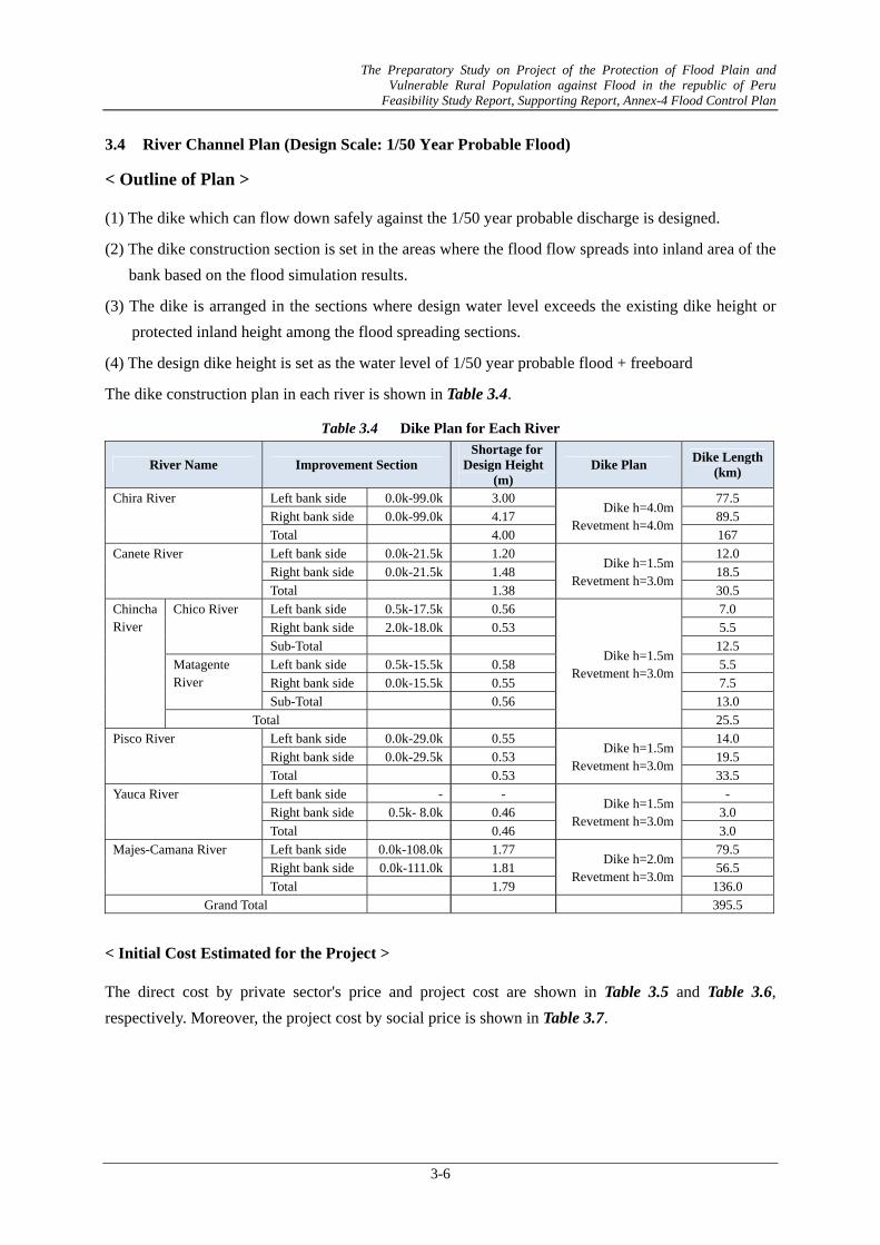
3.4 River Channel Plan (Design Scale: 1/50 Year Probable Flood)
< Outline of Plan >
(1) The dike which can flow down safely against the 1/50 year probable discharge is designed.
(2) The dike construction section is set in the areas where the flood flow spreads into inland area of the bank based on the flood simulation results.
(3) The dike is arranged in the sections where design water level exceeds the existing dike height or protected inland height among the flood spreading sections.
(4) The design dike height is set as the water level of 1/50 year probable flood + freeboard
The dike construction plan in each river is shown in Table 3.4.
Table 3.4 Dike Plan for Each River
River Name Improvement Section Shortage for Design Height
(m) Dike Plan Dike Length
(km)
Chira River Left bank side 0.0k-99.0k 3.00 Dike h=4.0m
Revetment h=4.0m
77.5 Right bank side 0.0k-99.0k 4.17 89.5 Total 4.00 167
Canete River Left bank side 0.0k-21.5k 1.20 Dike h=1.5m
Revetment h=3.0m
12.0 Right bank side 0.0k-21.5k 1.48 18.5 Total 1.38 30.5
Chincha River
Chico River Left bank side 0.5k-17.5k 0.56
Dike h=1.5m Revetment h=3.0m
7.0 Right bank side 2.0k-18.0k 0.53 5.5 Sub-Total 12.5
Matagente River
Left bank side 0.5k-15.5k 0.58 5.5 Right bank side 0.0k-15.5k 0.55 7.5 Sub-Total 0.56 13.0
Total 25.5 Pisco River Left bank side 0.0k-29.0k 0.55
Dike h=1.5m Revetment h=3.0m
14.0 Right bank side 0.0k-29.5k 0.53 19.5 Total 0.53 33.5
Yauca River Left bank side - - Dike h=1.5m
Revetment h=3.0m
- Right bank side 0.5k- 8.0k 0.46 3.0 Total 0.46 3.0
Majes-Camana River Left bank side 0.0k-108.0k 1.77 Dike h=2.0m
Revetment h=3.0m
79.5 Right bank side 0.0k-111.0k 1.81 56.5 Total 1.79 136.0
Grand Total 395.5
< Initial Cost Estimated for the Project >
The direct cost by private sector's price and project cost are shown in Table 3.5 and Table 3.6, respectively. Moreover, the project cost by social price is shown in Table 3.7.
The Preparatory Study on Project of the Protection of Flood Plain and Vulnerable Rural Population against Flood in the republic of Peru
Feasibility Study Report, Supporting Report, Annex-4 Flood Control Plan
3-7
Table 3.5 Direct Construction Cost for the Whole Flood Control Plan
Construction of dike Revetment protectionB1 H1 B2 A B1 H2 B2 A
The Preparatory Study on Project of the Protection of Flood Plain and Vulnerable Rural Population against Flood in the republic of Peru
Feasibility Study Report, Supporting Report, Annex-4 Flood Control Plan
4-1
CHAPTER 4 MAINTENANCE PLAN
Formulation of the channel plan in consideration of the sediment dynamic state is a basic theme in this study. Based on one-dimensional-riverbed-fluctuation analysis, sections caused by sedimentation/erosion are grasped and the countermeasures against them are planned.
As for the current situation in rivers, sections which located road bridges, farm facilities (diversion weirs), etc. are narrow areas, and upstream of narrow areas have tendency of sedimentation.
In the maintenance plan, discharge capacity in narrow areas is enhanced, and sediments are kept not to accumulate in the channel of narrow areas and its upstream section. Moreover, it is planned so that the sediment is stored as much as possible in the upstream section (wide river channel) located upstream of the narrow areas at the occurrence of the scale of exceeding 1/50 scale flood.
Based on the riverbed-fluctuation simulation results for 6 (six) rivers at the 50 years after, the sections or places where the maintenance works should be done are selected and arranged as shown below.
The Preparatory Study on Project of the Protection of Flood Plain and Vulnerable Rural Population against Flood in the republic of Peru
Feasibility Study Report, Supporting Report, Annex-4 Flood Control Plan
4-2
Table 4.1 Sections/Places to be Carried Out Maintenance Works
River Name Excavation Area Method of Maintenance Works Chira River Place1 Target Section:
64.0km-68.0km Target Volume:2,500,000m3
Since sediments will accumulate in the upstream of Sullana Weir, it is considered that sediments should be removed periodically from now on. Since the amount of sediment is extensive and it is actually difficult to remove all, it is considered to be especially important that the excavation for maintenance should be carried out preponderantly in the right upstream of the weir.
Canete River Place1 Target Section:3.0km-7.0kmTarget Volume:135,000m3
It is a past flood occurrence part. Since the riverbed aggradation advances gradually, it is considered that periodical excavation should be carried out from now on.
In the object section, the channel is narrow, and since sediments are not fully passed, the possibility of riverbed aggradation is high. Since the riverbed aggradation advances gradually from now on and flood may be occurred, the periodical excavation maintenance should be carried out.
It is a existing flood part. Since the riverbed aggradation advances gradually, it is considered that periodical excavation should be carried out from now on.
The channel is wide and the section where sediment tend to deposit. Since the riverbed aggradation advances gradually from now on and flood may be caused, the periodical excavation maintenance should be carried out.
In the section, sediment tends to deposit in the upstream of the existing intake weir. By the periodical excavation in the section, it is thought to be possible to reduce the riverbed aggradation risk in the whole downstream channel.
Yauca River Place1 Target Section:25.5km-26.5km Target Volume:60,000m3
The section locates in the direct upstream of an existing intake weir. In order to keep the function of the weir, the periodical excavation maintenance should be carried out.
Majes-Camana River Place1 Target Section:12.0km-13.0km Target Volume:70,000m3
It is comparatively narrow section. The possibility that a remarkable riverbed aggradation will occur also in small amount of sediment is surmised to be high. Periodical excavation maintenance every year is desirable in consideration of the influence on intake facilities.
The Preparatory Study on Project of the Protection of Flood Plain and Vulnerable Rural Population against Flood in the republic of Peru
Feasibility Study Report, Supporting Report, Annex-4 Flood Control Plan
It is a wide channel section. It has high possibility that a lot of sediment accumulates easily. By carrying out excavation maintenance in the section, it is expectable that the effectiveness of the riverbed aggradation in the middle stream can be also controlled. The place is considered to be carried out the planned excavation maintenance from the viewpoint on flood control.
※Design sediment volume: Sediment volume deposited in 50 years
Table 4.2 Direct Construction Cost for Chanel Excavation
Quantity Unit Unit price Direct Construction Cost(M m3) (Sol) (M Soles)
The Preparatory Study on Project of the Protection of Flood Plain and Vulnerable Rural Population against Flood in the republic of Peru
Feasibility Study Report, Supporting Report, Annex-4 Flood Control Plan
4-4
Nom
bre d
ela
Cuenca
Cost
oD
irecto
(sole
s)
Cost
o d
e O
bras
Tem
pora
les
Cost
o d
e O
bras
Gas
tos
Ope
rati
vos
Uti
lidad
Cost
o T
ota
lIn
frae
stru
ctu
raIG
VC
ost
o T
ota
lO
bra
Impa
cto
Am
bienta
lExp
edi
ente
Tecnic
oS
upe
rvis
ión
Cost
o T
ota
l
Riv
er b
asin
Dire
ctco
nstr
uctio
n co
st
Com
mon
tem
pora
ry w
ork
cost
Con
stru
ctio
n cos
tO
verh
ead
cost
Pro
fit
Str
uctu
res
cons
truction
cost
Tax
Con
str
uct
ion c
ost
Env
ironm
ent
al
Impact
Deta
iled
Desi
gn
Const
ruction
manag
ement
cost
Pro
ject
Cos
t
(1)
(2)
= 0
.1*(1
)(3
) = (
1)
+ (
2)
(4)
= 0
.15*(3
)(5
) = 0
.1*(3
)(6
) = (
3)+
(4)+
(5)
(7
) = 0
.18*(6
)(8
) = (
6)+
(7)
(9)=
0.0
1*(8
)(1
0)
= 0
.05*(8
)(1
1)
= 0
.1*(8
)(1
2)
= (
8)+
(9)+
(10)+
(11)
CH
IRA
25,0
00
2,5
00
27,5
00
4,1
25
2,7
50
34,3
75
6,1
88
40,5
63
406
2,0
28
4,0
56
47,0
53
CA
ÑET
E4,2
20
422
4,6
42
696
464
5,8
03
1,0
44
6,8
47
68
342
685
7,9
42
CH
INC
HA
4,7
90
479
5,2
69
790
527
6,5
86
1,1
86
7,7
72
78
389
777
9,0
15
PIS
CO
5,6
90
569
6,2
59
939
626
7,8
24
1,4
08
9,2
32
92
462
923
10,7
09
YA
UC
A600
60
660
99
66
825
149
974
10
49
97
1,1
29
MA
JES
-C
AM
AN
A5,3
00
530
5,8
30
875
583
7,2
88
1,3
12
8,5
99
86
430
860
9,9
75
TO
TA
L45,6
00
4,5
60
50,1
60
7,5
24
5,0
16
62,7
00
11,2
86
73,9
86
740
3,6
99
7,3
99
85,8
24
Nom
bre d
ela
Cuenca
Cost
oD
irecto
(sole
s)
Cost
o d
e O
bras
Tem
pora
les
Cost
o d
e O
bras
Gas
tos
Ope
rati
vos
Uti
lidad
Cost
o T
ota
lIn
frae
stru
ctu
raIG
VC
ost
o T
ota
lO
bra
Fac
tor
deC
orr
ecció
nC
ost
o T
ota
lO
bra
Impa
cto
Am
bienta
lExp
edi
ente
Tecnic
oS
upe
rvis
ión
Cost
o T
ota
l
Riv
er b
asin
Dire
ctco
nstr
uctio
n co
st
Com
mon
tem
por
ary
wor
k
cost
Con
stru
ctio
n cos
tO
verh
ead
cost
Pro
fit
Str
uctu
res
cons
truct
ion
cost
Tax
Con
stru
ctio
n cos
tC
orre
ctio
n Fact
or
Cons
truc
tion
cos
tEnv
iron
men
tal
Impa
ct
Det
aile
d D
esig
n
Con
stru
ctio
n
man
agem
ent
cost
Pro
ject
Cos
t
(1)
(2)
= 0
.1*(1
)(3
) = (
1)
+ (
2)
(4)
= 0
.15*(3
)(5
) = 0
.1*(3
)(6
) = (
3)+
(4)+
(5)
(7
) = 0
.18*(6
)(8
) = (
6)+
(7)
Cf
(9)
= C
f*(8
)(1
0)=
0.0
1*(9
)(1
1)
= 0
.05*(9
)(1
2)
= 0
.1*(9
)(1
3)
= (
9)+
(10)+
(11)+
(12)
CH
IRA
25,0
00
2,5
00
27,5
00
4,1
25
2,7
50
34,3
75
6,1
88
40,5
63
0.8
04
32,6
12
326
1,6
31
3,2
61
37,8
30
CA
ÑET
E4,2
20
422
4,6
42
696
464
5,8
03
1,0
44
6,8
47
0.8
04
5,5
05
55
275
551
6,3
86
CH
INC
HA
4,7
90
479
5,2
69
790
527
6,5
86
1,1
86
7,7
72
0.8
04
6,2
49
62
312
625
7,2
48
PIS
CO
5,6
90
569
6,2
59
939
626
7,8
24
1,4
08
9,2
32
0.8
04
7,4
23
74
371
742
8,6
10
YA
UC
A600
60
660
99
66
825
149
974
0.8
04
783
839
78
908
MA
JES
-C
AM
AN
A5,3
00
530
5,8
30
875
583
7,2
88
1,3
12
8,5
99
0.8
04
6,9
14
69
346
691
8,0
20
TO
TA
L45,6
00
4,5
60
50,1
60
7,5
24
5,0
16
62,7
00
11,2
86
73,9
86
59,4
86
594
2,9
74
5,9
48
69,0
02
Tab
le 4
.3
Pro
ject
Cos
t for
Cha
nnel
Exc
avat
ion
(Mar
ket P
rice
)
Tab
le 4
.4
Pro
ject
Cos
t for
Cha
nel E
xcav
atio
n (S
ocia
l Pri
ce)
The Pr Vu
Fea
reparatory StuVulnerable Rura
asibility Study R
4-5
Fig
ure
4.1
S
edim
enta
tion
Sect
ion
to b
e ca
rrie
d ou
t Mai
nten
ance
Wor
ks (C
hira
Riv
er)
dy on Project al Population Report, Suppor
of the Protecagainst Flood ting Report, An
ction of Flood d in the republnnex-4 Flood C
Plain and lic of Peru ontrol Plan
Fig
ure
4.2
S
edim
enta
tion
Sect
ion
to b
e ca
rrie
d ou
t Mai
nten
ance
Wor
ks (C
anet
e R
iver
)
The Pr Vu
Fea
reparatory StuVulnerable Rura
asibility Study R
4-6
Fig
ure
4.3
S
edim
enta
tion
Sect
ion
to b
e ca
rrie
d ou
t Mai
nten
ance
Wor
ks (C
hinc
ha (C
hico
) Riv
er)
dy on Project al Population Report, Suppor
of the Protecagainst Flood ting Report, An
ction of Flood d in the republnnex-4 Flood C
Plain and lic of Peru ontrol Plan
Fig
ure
4.4
S
edim
enta
tion
Sect
ion
to b
e ca
rrie
d ou
t Mai
nten
ance
Wor
ks (C
hinc
ha (M
atag
ente
) Riv
er)
The Pr Vu
Fea
reparatory StuVulnerable Rura
asibility Study R
4-7
Fig
ure
4-5
S
edim
enta
tion
Sect
ion
to b
e ca
rrie
d ou
t Mai
nten
ance
Wor
ks (P
isco
Riv
er)
dy on Project al Population Report, Suppor
of the Protecagainst Flood ting Report, An
ction of Flood d in the republnnex-4 Flood C
Plain and lic of Peru ontrol Plan
Fig
ure
4-6
S
edim
enta
tion
Sect
ion
to b
e ca
rrie
d ou
t Mai
nten
ance
Wor
ks (Y
auca
Riv
er)
The Pr Vu
Fea
reparatory StuVulnerable Rura
asibility Study R
4-8
dy on Project al Population Report, Suppor
of the Protecagainst Flood ting Report, An
Fig
ure
4-7
S
edim
enta
tion
Sect
ion
to b
e ca
rrie
d ou
t Mai
nten
ance
Wor
ks (M
ajes
- C
aman
a R
iver
)
ction of Flood d in the republnnex-4 Flood C
Plain and lic of Peru ontrol Plan
The Preparatory Study on Project of the Protection of Flood Plain and Vulnerable Rural Population against Flood in the republic of Peru
Feasibility Study Report, Supporting Report, Annex-4 Flood Control Plan
4-9
For advancing on river improvement, the sections with high priority (section where the serious damage is expected by floods, section which has great effects on local economic activities, etc.) are improved immediately in consideration of the characteristics of rivers. After that, works is carried out from the downstream section by taking into consideration the scale of improvement plan. (For over all construction plan, it is based on securement of the safety scale for flood control from the downstream section)
The selection procedure for river improvement sections with high priority is shown next chapter.