THE SANTO TOMAS CANNEL COAL, WEBB COUNTY, TEXAS. By GEORGE H. ASHLEY. INTRODUCTION. The cannel coal of Santo Tomas (sahn'toe toe-mahss'), Webb County, Tex., is of unique interest, both economically .and geo- logically. It is of economic interest Because it is probably the largest body of cannel coal of bituminous rank in the United States, if not in the world. It is of geologic interest because it is not the high-moisture, soft brown lignite which is characteristic of coal beds of the same age in the central and eastern parts of the State, but a low-moisture coal almost as hard as anthracite, resisting weathering like an ordinary bituminous coal and sold on Government contracts under a guaranty of 12,500 British thermal units on "dry coal." As a cannel coal it has special interest because on distillation such coal yields a much larger proportion of oil at a low temperature or of gas at a high temperature than ordinary bituminous coal, and at present and probably for some time in the future these products may be in great demand in the growing chemical industry of the United States. Kecent tests by the Bureau of Mines have shown that although cannel coal yields a large percentage of oil when distilled at a low temperature, yet this oil contains so large a percentage of un- saturated hydrocarbons as to be unavailable for the manufacture of benzol and toluol products, which are in large demand at this time for the manufacture of high explosives. Most deposits of cannel coal are too small to justify the erection near by of a distillation plant of any considerable size for their utilization, but the amount of coal already in sight in this district warrants its investigation by those interested in chemical industries. (See p. 266.) A by-product of mining here is the large amount of clay that has to be removed in the mining operations. The clay already removed forms very large clumps (see PI. XXXII) and lies ready for use in the manufacture of any clay products for which it may be suited. It will probably riot be found suitable for high-grade fire brick, but rather for vitrified ware, sewer pipe, draintile, and possibly paving brick. This coal, which has been extensively mined for many years, is now used on eight or more railroads and in manufacturing plants 251
Transcript
THE SANTO TOMAS CANNEL COAL, WEBB COUNTY, TEXAS.
By GEORGE H. ASHLEY.
INTRODUCTION.
The cannel coal of Santo Tomas (sahn'toe toe-mahss'), Webb County, Tex., is of unique interest, both economically .and geo logically. It is of economic interest Because it is probably the largest body of cannel coal of bituminous rank in the United States, if not in the world. It is of geologic interest because it is not the high-moisture, soft brown lignite which is characteristic of coal beds of the same age in the central and eastern parts of the State, but a low-moisture coal almost as hard as anthracite, resisting weathering like an ordinary bituminous coal and sold on Government contracts under a guaranty of 12,500 British thermal units on "dry coal." As a cannel coal it has special interest because on distillation such coal yields a much larger proportion of oil at a low temperature or of gas at a high temperature than ordinary bituminous coal, and at present and probably for some time in the future these products may be in great demand in the growing chemical industry of the United States. Kecent tests by the Bureau of Mines have shown that although cannel coal yields a large percentage of oil when distilled at a low temperature, yet this oil contains so large a percentage of un- saturated hydrocarbons as to be unavailable for the manufacture of benzol and toluol products, which are in large demand at this time for the manufacture of high explosives. Most deposits of cannel coal are too small to justify the erection near by of a distillation plant of any considerable size for their utilization, but the amount of coal already in sight in this district warrants its investigation by those interested in chemical industries. (See p. 266.) A by-product of mining here is the large amount of clay that has to be removed in the mining operations. The clay already removed forms very large clumps (see PI. XXXII) and lies ready for use in the manufacture of any clay products for which it may be suited. It will probably riot be found suitable for high-grade fire brick, but rather for vitrified ware, sewer pipe, draintile, and possibly paving brick.
This coal, which has been extensively mined for many years, is now used on eight or more railroads and in manufacturing plants
251
252 CONTRIBUTIONS TO ECONOMIC GEOLOGY, 1918, PART II.
and has a growing use as a household fuel. Before the Mexican revolution it was much used by Mexican railroads and industries, supplying most of the territory that uses Laredo as a gateway. Its main drawbacks are the great cost of mining, due to thinness of beds and poor roof, and its high ash and sulphur content.
The. coal is of Eocene (early Tertiary) age and, according to Vaughan, belongs in the Claiborne group, in contrast with lignite beds farther north, which are of Wilcox age. It lies nearly flat and almost undisturbed by horizontal pressure or mountain-building forces. The gxistence in the coal of fairly close-set joint faces, however, suggests that there has been some slight pressure in this area, which, in combination with the effect of dry climate, may account for the low percentage of moisture and corresponding high rank of the coal. The low^ moisture may result from the cannel character of the coal, as discussed beyond.
LOCATION.
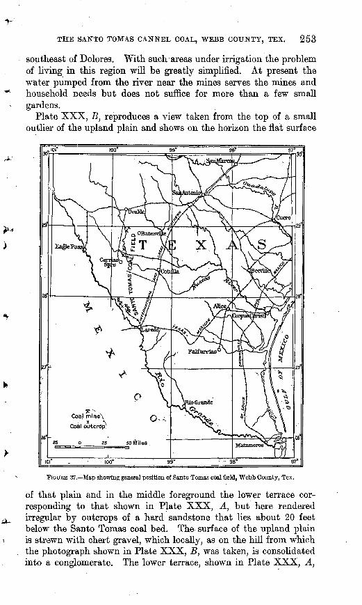
The Santo Tomas coal field, as shown in figure 37, lies on the Rio Grande between Laredo and Eagle Pass, not far from Laredo. The boundaries of the field have not yet been determined, so that its possible extent is known only so far as to include the mines and prospects shown on the map. (See PI. XXIX.) The developed area lies close to the Rio Grande, from 23 to 27 miles above Laredo, with which it is connected by the Rio Grande & Eagle Pass Railway. From Laredo the International & Great Northern Railway runs north to San Antonio and west of south 150 miles to Monterrey, Mexico; and the Texas-Mexican Railway runs east to Corpus Christi.
GENERAL PHYSICAL FEATURES OF THE REGION.
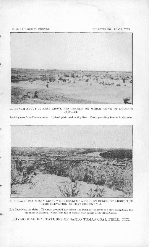
This coal field lies within the Rio Grande Plain, a part of the Gulf Coastal Plain, which is prolonged up the Rio Grande. This vast plain, here inclined southeastward at a rate of about 3 feet .to the mile (see PI. XXX, B], has been dissected by the streams, which now lie considerably below its level. The larger stream valleys are bordered by series of terraces. Near the 'Rio Grande this plain is eroded into an irregular escarpment by the smaller drainageways the "breaks" of the Rio Grande. In places the plain reaches almost or quite to the river, but in general it is separated by terraces ranging from a fraction of a mile to several miles in width. Plate XXX, A, shows a view from such a terrace, about 75 feet above the river. This terrace is nearly destitute of vegetation in the dry season but is capable of cultivation by irrigation. Large areas of this terrace near Laredo are now irrigated, the water being derived from the Rio Grande by pumping and distributed by pipes and ditches. Plans are being considered for the irrigation of several thousand acres
-y-
V. 8. GEOLOGICAL SURVEY BULLETIN 691 PLATE XXIX
SANTO TOMAS TR/\CT
TOWN OF SANTO TOMAS
SANTO rOMAS SHAFT
KEY MAP OF PART OF WEBB COUNTY,TEXASHOWING 'LOCATION OF PRODUCTIVE AREA OF
SANTO TOMAS COAL FIELD
SKETCH MAP OF PRODUCTIVE PORTION OF SANTO TOMAS COAL FIELD, WEBB COUNTY, TEX.
THE SANTO TOMAS CANNEL COAL, WEBB COUNTY, TEX. 253
southeast of Dolores. With such areas under irrigation the problem of living in this region will be greatly simplified. At present the water pumped from the river near the mines serves the mines and household needs but does not suffice for more than a few small gardens.
Plate XXX, B, reproduces a view taken from the top of a small outlier of the upland plain and shows on the horizon the flat surface
100
FIGUHE 37. Map showing general position of Santo Tomas coal field, Webb County, Tex.
of that plain and in the middle foreground the lower terrace cor responding to that shown in Plate XXX, A, but here rendered irregular by outcrops of a hard sandstone that lies about 20 feet below the Santo Tomas coal bed. The surface of the upland plain is strewn with chert gravel, which locally, as on the hill from which the photograph shown in Plate XXX, B, was taken, is consolidated into a conglomerate. The lower terrace, shown in Plate XXX, A,
254 CONTRIBUTION'S TO ECONOMIC GEOLOGY, 1918, PART II.
consists of silt, in places underlain by gravel which at Dolores is 16 feet thick and is a clean sand gravel free of clay.
The vegetation of the region consists of grasses (in seasons of rain), mesquite, prickly pear, and other prickly plants, but no trees. Rains are infrequent. At the time of the writer's visit it was reported that more than a year had elapsed since the latest good rain. The aver age annual rainfall at Laredo for 23 years is given as 19.58 inches and at Eagle Pass 25.01 inches. 1 These figures would indicate for the Santo Tomas area an annual precipitation of about 22 inches. Weather charts for individual years appear to give lower figures than those quoted. For example, in 1908 the precipitation at Eagle Pass was 15.16 inches, and in 1909 it was 8.63 inches. The general weather map for 1910 gives this area a precipitation of 12 inches; for 1915, 16 inches; for 1916, 14 inches.
The average temperature for the year is about 72° F., with maxima ranging from about 80° in January to 110° in July, and minima from about 20° in January to 55° in July. The monthly mean minima for five years (1880-1885) gave about 40° in January and 70° in July. The monthly means of daily maxima are about 65° for Jan uary and between 90° and 100° in July. The mean temperature for January is about 53° and for July 87°. There are many hot days in July and August, but during the writer's visit in August, 1917, the heat was tempered by a breeze that blew almost constantly from the south and southeast, and it is said that such a breeze is characteristic of the region.
THE COAL.
PHYSICAL PROPERTIES.
The Santo Tomas coal is a bright, glossy black coal, almost like pitch in appearance, having a more brilliant luster than most other cannel coals. It is firm, yielding from 75 to 80 per cent of lump as mined and screened over 1^-inch bars. As dug in the mine it is as hard as or harder than the average bituminous coal, approaching splint coal in this respect. It can be shipped in open cars to any dis tance without deterioration, and it can be stored and if free from sulphur will remain in good condition many months. If much pyrite is left in the coal stored, however, the oxidation of the pyrite tends to break the coal down, so that at the end of a year, it is reported, the percentage of slack in the coal is largely increased.
The coal does not split readily with the bedding but has a strong cleat, or vertical cleavage, in one direction (N. 30° E. in the bed) that breaks the coal vertically and aids in mining. The cross fracture is roughly conchoidal. The coal appears massive in the bed, but locally, where the ash content is very high and the bed deeply weath-
1 R,eilly, A. W., Climatic conditions of Texas: 52d Gong., 1st sess., S. Ex. Doc. 5,1894.
U. S. GEOLOGICAL SURVEY BULLETIN 691 PLATE XXX
A. BENCH ABOUT 75 FEET ABOVE HIO GRANDE ON WHICH TOWN OF DOLORESIS BUILT.
Looking east from Dolores mine. Upland plain makes sky line. Camp guarding border in distance.
B. UPLAND PLAIN (SKY LINE), "THE BRAKES," A BROKEN BENCH OF ABOUT THE SAME ELEVATION AS THAT SHOWN IN A.
Rio Grande at the right. The gray pyramid just above the bend of the river is a clay dump from the old mine at Minera. View from top of outlier near moulh of Artillero Cr&ek.
PHYSIOGRAPHIC FEATURES OF SANTO TOMAS COAL FIELD, TEX.
THE SANTO TOMAS CANNEL COAL, WEBB COUNTY, TEX. 255
ered, it tends to split into paper-thin sheets parallel with the bedding. The coal has a brown streak and where high in ash is decidedly brown on the weathered outcrop, though some that is better quality appears as black as an ordinary bituminous coal. The bony part of the coal especially has locally the appearance of a well-rotted log at the sur face exposure. The coal has a specific gravity of 1.29, as determined in two tests by George Steiger on coal from the Dolores mine. It burns with a long flame and produces an abundance of smoke, as might be assumed from the high percentage of volatile material.
The facts show this coal to be neither a lignite nor a subbituminous coal but to be of bituminous rank. It has neither the high moisture of brown coal, the woody structure of lignites, nor the tendency to split and fall to pieces as soon as exposed to the weather characteristic of the subbituminous coals. In color, percentage of moisture, re sistance to the weather, and heat value it compares favorably with the coals of Illinois, Indiana, Michigan, Iowa, and Missouri.
CHEMICAL PROPERTIES.
ANALYSES.
The tables of chemical analyses given beyond show this coal to be high in volatile matter, which averages about 25 per cent greater than the fixed carbon, giving the coal a fuel ratio (fixed carbon divided by volatile matter) of about 0.8. As bituminous coals having a fuel ratio of less than 1 are classed as cannel coal this coal is ranked as a cannel coal of the bituminous class. Although it differs somewhat from some of the typical cannels, this coal has many of the dis tinguishing features of a cannel, including in some measure .the char acteristic conchoidal fracture and massive fine-grained texture.
The surprising feature of this coal is its-low moisture content, about 4 per cent, compared with that of most of the bituminous coals west of the Appalachian field, which .ranges from .6 to 16 per cent. The fact that the bituminous coal of New Mexico also has a low moisture content suggests that it may 'be due partly to climate, but as water flows into the mine at Santo Tomas even during the dry season, it can not be assumed that this coal is above the water table and therefore has opportunity to dry out. Nor does a comparison of the moisture content of the lignites of Texas with those of other States strongly support this inference. The lignite of Medina County, which is not far northeast of the Santo Tomas area, shows 32 per cent moisture, and the lignite of Milam County carries 35.5 to 36 per cent, as compared with 40 per cent in Ouachita County, Ark., and 32 to 40 per cent in the coals of some parts of North Dakota. A general study of the mois ture content of coals seems to indicate that different coals have in herent qualities, due possibly to the colloidal condition of some of the
256 CONTRIBUTIONS TO ECONOMIC GEOLOGY, 1918, PART II.
material, by virtue of which they tend to carry an amount of moisture that for any given vapor pressure is characteristic of the coal. In general the cannel or canneloid coals run low in moisture. Thus the cannel coal from Cannelburg, Ind., has a moisture content, as received, between 1 and 2 per cent, though surrounded by coal in which the moisture content is from 7.5 to over 13 per cent. The cannel coal at Flambeau and Lesley, Ky., has a moisture content of 1.7 to 2.3 per cent, though the other coals of the same county run from" 5.1 to 6.9 per cent. It would therefore seem likely that the principal cause of the low moisture content of the Santo Tomas coal is some feature in the physical structure of the coal itself, characteristic of cannel coals in general.
This coal is lu'gh in ash, as shown by the analyses, though individual specimens and samples may run as low as 8 or 9 per cent. The average samples contain between 12 and 23 per cent, with an average probably not farfrom 16. So too, it is high in " sulphur," the average probably being about 2 per cent. The percentage of hydrogen, about 5.75, is approximately the same as1 that of the average coal of the ulterior province.
An interesting feature of this coal is, the large percentage of nitro gen shown in certain of the analyses. If those analyses are correct this coal contains more nitrogen than any other coal in the United States. The samples taken by the writer have not yielded so high a percentage of nitrogen as some of the older samples. Most coals contain between 0.5 and 1.5 per cent of nitrogen, but in some areas, notably parts of Washington and northern Tennessee, many of the coals contain 2 per cent and some run as high as 3.5 per cent of nitro gen in the sample as received. At first sight thes.e figures would seem to indicate that the Santo Tomas coal might be of great value in the production of certain desired distillation products containing nitro gen, such as ammonia and toluol, but, as pointed out on page 251, experiments have shown that the oil arid gas obtained from cannel coal are given off so readily and at so. low a temperature that they consist largely of unsaturated hydrocarbons which will not yield by any known process the nitrogen by-products desired. If, however, a process could be devised by which they could be changed into the aromatic series by the addition of hydrogen they might become of great value.
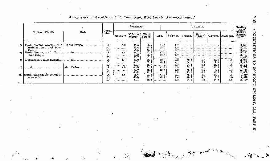
Analyses ofcannel coal from Santo Tomas field, Webb County, Tex.
12
3 4 5 6
7
8
9
10 11
12
13
14
15
16
17 18 19
20
21
Mine or locality.
Santo Tomas (?)..............25 miles northwest of Santo
Tomas.
.....do........................
.....do........................
.....do........................
.....do........................
(?)...........................
Cannel (Darwin), San Jose, and No. 3, average of 10 anal yses run of mine.
THE SANTO TOMAS CANNEL COAL, WEBB COUNTY, TEX. 259
1. Penrose, B. A. F., A preliminary report on the geology of the Gulf Tertiary of Texas from Bed Biver to the BloGrande: Texas Geol. Survey First Ann. Bept., p. 97, 1890.
2. Bumble, E. T., Beport on the brown coal and lignite of Texas, p. 190, Texas Geol. Survey, 1892.
3-7. Vaughan, T. W., Beconnaissance in the Bio Grande coal fields of Texas: TJ. S. Geol. Survey Bull. 164, pp. 64-65,1900. Peter Fireman, analyst.
8-9. Phillips, W. B., Coal, lignite, and asphalt rocks: Texas Univ. Man. Survey Bull. 3, p. 52, 1902. Samples cut in,mines and analyses made by 0. H. Palm and S. H. Worrell.
10-18. Phillips, W.. B., and Worrell, S. H., Fuels used in Texas: Texas Univ. Bull. 307, pp. 14, 20, 33, 34, 50,1913; S. H. Worrell, analyst, except as stated; 10, 11, sent by companies at solicitation of university in cans furnished by university; 12, represents lot of 1,000 pounds taken by a member of the United States Geological Survey for test at Pittsburgh for War Department; 13, "Llave coal," presumably from prospect on San Pedro bed in Llave Creek near mouth, J. R. Bailey, analyst; 14, sample of 25 pounds received June 17,1912, from company; 15, sample ("special") taken at University of Texas power house; 16, same ("carloads"); 17, 18,"analyses made in connection with dry distillation tests (for gas).
19. Pope, G. S., Analyses of coals purchased by the Government, 1908-1915 : Bur. Mines Bull. 119, pp. 38, 39, 85,1916. Average of 10 samples, from coal delivered to Fort Mclntosh, Tex. Contract guaranties: 16.53 per cent ash, "dry coal"; 11,588 British thermal units, " as received.'' Price, $5.60 a ton.
20. Average of 12 samples from 4,336 tons of 4-inch lump coal delivered to Fort Sam Houston, Tex., 1916-17. Contract guaranties: 3.7 per cent moisture, "as re ceived"; 47 per cent volatile matter, "dry coal"; 13.5 per centash, "dry coal"; and 12,500 British thermal units, "dry coal." Price, $5.25 a ton.
21. Average of 3 samples from 173 tons of lump coal delivered to Fort Mclntosh, Tex., 1916-17. Contract guaranties: 2.7 per cent moisture, "as received"; 47 per cent volatile matter, "dry coal"; 13.5 per cent ash, "dry coal." Price, $4.50 a short ton.
22. Average of 5 samples from 165 tons of lump coal, over 3-inch screen, delivered to Fort Mclntosh, Tex., 1915-16. Contract guaranties: 4 per cent moisture, "aa received"; 50 per cent volatile matter, "dry coal"; 13.5 per cent ash, "dry coal"; and 12,000 British thermal units, "as received." Price, $4.50 a ton.
23. Sample cut by G. H. Ashley in break-through being cut between rooms 118 and 119, 2,800 feet from shaft. Coal where cut 30 inches thick, not including 2-inch layer of bone 15 inches from top.
24. Sample cut by G. H. Ashley in room 20, entry N, 800 feet N. 60° E. from foot of shaft. Bed 28 inches thick where cut.
25. Sample cut by G. H. Ashley in face of I entry, 1,000 feet due west of foot of shaft. Coal where cut 22inch.es thick.
26. Sample cut by G. H. Ashley in side of drift 30 feet from mouth, to test effect of weathering in coals. Coal where cut 26 inches thick.
GAS-PRODUCING QUALITIES.
A study of the gas-making qualities of these coals, with reference to the production of water gas, was made by the University of Texas. The results of the experiments, which were conducted by Phillips and Worrell, are included in the report on a series of tests of the gas- producing properties of a number of Texas coals. 1 Analyses of the
i Phillips, W. B., and Worrell, S. H., Fuels used in Texas: Texas Univ. Bull. 307,1913.
260 CONTRIBUTIONS TO ECONOMIC GEOLOGY, 1918, PART II.
coals used are given in the preceding table (Nos. 17 and 18). The results of the tests are listed below:
Results of gas distillation tests on Santo Tomas coal.
After the distillation above recorded a residue that yielded the following results was left in the retorts:
Composition and character of residue from gas distillation tests of Santo Tomas coal.
Ash.......................................
Yield......... ...........................
...............................do....
...............................do....
........................... .per cent. .
s* a±"""" mine.
3. 51 8. 1178. 31 73. 6318. 18 18. 262.01 1.35
12,050 11,66461. 25 62. 5Fair. Fair.
LOW-TEMPERATURE DISTILLATION.
The tests of the Santo Tomas coal by low-temperature distillation by the Bureau of Mines gave the following results:
Oil:Gallons per ton. V. ........................................ 52. 2Per cent by weight of coal. ................................. 20. 2
fifl° Specific gravity at ~ F. ....:............................. 0. 938
60Nonliquid at 60° F.
Gas: Cubic feet per ton, collected over water, at 0° C. and 760 millimeters pressure. .............................. ̂ . ....... 5, 672
Water: Per cent by weight of coal condensed ................... 9. 5Loss in distillation: Per cent by weight. ....................... .^ 44. 3Ammonia: Not determined.
THE SANTO TOMAS CANNEL COAL, WEBB COUNTY, TEX. 261
1 Santo Tomas bed
San Pedroi coal bed 1
Ft. in. o
3 0
IS 0
2 03 010 0
Z9 0
44 0
4 O
6 0
II 0
Ft. in.
10 o
6 02 0
This yield of 52.5 gallons a ton may be compared with 50.4 and 37.3 gal lons a ton obtained by two tests under the same conditions of coal from Can- nelton, Pa., which in the past has been successfully used in the production of oil. There can be little doubt of the value of the Santo Toinas coal for this purpose, but as the oil, owing to the low temperature at which it distills off, is composed largely of unsaturated hy drocarbons and not of benzene and re lated substances, it is necessary, for the production of gasoline, toluol, andother substances that are now in great demand for war purposes, to devise some process such as "cracking" the oil or hydrogenation. The oil as it comes from the still is suitable for ordi nary burning and might prove accept able as flotation oil and for other spe cial uses. This field, on account of its large size and the abundance of coal in sight, would seem to be a favorable
place in which to determine by experiments what can be done with such an oil by dis tillation at different tempera tures and at different pres sures, and how the oils and tars obtained may be made available for gasoline and other much needed products.
COAL BEDS.
GEOLOGIC RELATIONS.
The Santo Tomas coal is interbedded with sandstone and shale of Eocene age. (See fig. 38.) According to the fol lowing section by Vaughan1 the lower of the two beds is about 850 feet above the base of the Eocene series:
LEGEND
Limestone
FIGURE 38. Sections showing general stratigraphy of the Santo Tornas coal field, Wcbb County, Tex. On left, prospect drilling No. 2, Cannel Coal Co.; on right, pros pect drilling No. 6, Pilote ranch, Cannel Coal Co,
1 Vaughan, T. W., Eeconnaissance in the Rio Grande coal fields of Texas: U. S. Geol. Survey Bull. 164, p. 45,1900.
262 CONTRIBUTIONS TO ECONOMIC GEOLOGY, 1918, PART II.
Resume of section of Eocene.Feet.
5. The coal beds and the clays and sandstone immediately overlying them were the highest beds seen. Between the two coal seams is a bed of fossils not yet determined.......................... 190
4. Below the coal beds is a series of alternations of clay, shale, andsandstones of a thickness of at least........................... 400
3. A series of fine-grained micaceous sandstone ..................^... 3002. The coarsely crystalline Carrizos and stone with a thickness of at
least....................................................... 1501. Bluish clays, ascertained by a well boring, below which are more
sandstones and clays.
The following section of a drilling by the Cannel Coal Co. was furnished to Vaughan 1 by D. D. Davis, of the company:
Section of prospect drilling No. 2,, Cannel Coal Co.
As shown by the first of the foregoing sections there are two beds of coal in this region, the Santo Tomas above and the San Pedro bed below, separated by about 90 feet of strata. The second section shows five layers of coal and several-additional bony layers.
The outcrop of the upper or Santo Tomas bed in the south bank of Espadilla Creek (No. 2, fig. 39) shows in the view given in Plate XXXI, A. The section at this point, which is well exposed, is asfollows:
1 Vaughan, T. W., Reconnaissance in the Rio Grande coal fields of Texas: U. S. Gcol. Survey Bull. 164, p. 42, 1900.
264 CONTRIBUTIONS TO ECONOMIC GEOLOGY, 1918, PAET II.
......20' ,
12'
.6'
*
=5=
2l'
M
tk
I5 r+
-EGE
| Coa
FIGURE 39. Detailed sections of rocks ex posed in Santo Tomas coal field, Webb County, Tex., as measured in outcrop. 1, Hunt mine and bridge 37; 2, Espadilla Creek; 3, near mine No. 2 above Minera; 4, near mine No. 1 above Minera.
The strata under the coal at the bottom of this section are exposed in Santo Tomas Creek and in a little drain below bridge 37 of the Rio Grande & Eagle Pass Railway. At the latter place is shown 30 feet of hard white fine-grained saccharoidal sandstone, the middle 6 feet of which is shaly. This sandstone makes the top of the cliffs facing Santo Tomas Creek above the railway bridge, as shown in Plate XXXI, B. The sec tion at this point shows 10 feet of massive to thin-bedded yellow and buff saccharoidal sandstone overly ing 10 feet of material that looks like shale but consists of thin lenses of white sandstone, each not over an eighth of an inch thick, coated with a film of dark-drab shale; the mass is shown to be sand by breaking open one of the thin laminae. About 30 feet lower in the dry bed of the creek are alternating layers of sandstone and shale about 2 feet thick. The sandstone is ripple marked and on weathering assumes the "bee rock" appearance common in many of the sandstones in^ the Appalachian coal region. The upper layer of this sand stone is whiter and harder than the o ther sandstones of the region. 11 ap pears to be fairly persistent through out the area examined.
The sandstone over the coal ap pears to be very irregular. Thus near the top of the section on Espan- dilla Creek are two 4-foot layers of sandstone separated by 6 feet of gray clay, and the lower of the two beds is 16 feet above the "rider" coal, which is over the Santo Tomas bed. A short distance up the river, near mine No. 2, the lower sandstone is 20 feet thick and lies 6 feet above the
THE SANTO TOMAS CANNEL COAL, WEBB COUNTY, TEX. 265
"rider" coal. A short distance farther upstream the same sandstone is 10 feet thick and 30 feet above the "rider" coal. (See sections 2, 3, and 4, fig. 39.) Although variable these sandstones can be traced with some degree of continuity along all the "breaks3" of the river in this region.
About 130 feet above the Santo Tomas coal is the base of a sand stone, that shows rather prominently and can be traced in the upper part of the " breaks " of the Rio Grande. It is a gray to buff medium- soft sandstone, irregularly bedded. The irregularity of bedding is so pronounced as to make it difficult to determine the dip of the rocks.
All these sandstones are nearly as hard as the sandstones of the Paleozoic coal measures. The presence of interbedded clay in place of shale gives the general section a different aspect from that of the coal-bearing rocks of Carboniferous age. The clays are commonly full of crystals of gypsum or calcium sulphate.
In general the rocks of southeastern Texas have a gentle dip to the southeast, but the dips are a little greater than the slope of the country, so that each layer passes under those that crop out southeast of it. In portions of the Santo Tomas coal field, near the Rio Grande, the dip is to the northeast. At the Dolores mine it is N. 39° E. The dip is only about 2°, and the strike of the rocks is about the same as'the trend of the river. The Santo Tomas bed is exposed about 75 feet above the river from Dolores to Llave Creek, and the dip is suf ficient to carry the coal several hundred feet below the upland plain a short distance east of the river.
It has been thought by some that the dip is reversed on the Mexican side of the river, the river flowing along the crest of an anticline. Mr. R. W. Davis, however, informed the writer that prospecting on the Mexican side near Columbia showed a dip toward the river, in con formity with the dips on the east side.
SANTO TOMAS BED.
Sections of the Santo Tomas bed are shown in figure 40. So far as seen this bed is commonly from 24 to 36 inches thick and in most sections has a 2-inch parting near the middle. These figures do not take into account some 2 to 14 inches of bony coal at the bottom. The bony coal is said to be used locally, as at the pump house. From 14 inches to 20 feet above the coal is a thin persistent "rider" from 6 to 12 inches thick. This is commonly a bony coal but in places is fairly good. Commonly the rock between the Santo Tomas bed and the "rider" is clay, though several sections snow from 12 to 24 inches of brown shale immediately under the "rider"- coal. In the Dolores and Hunt mines the material between the Santo Tomas coal and the "rider" is a shale or shaly clay. Over the "rider" is
° J9 Bull. 691 18
266 CONTRIBUTIONS TO ECONOMIC GEOLOGY, 1918, PAET II.
locally a thin sandstone that in the Hunt mine helps materially in maintaining the roof of the entries.
8
Coat. .Bone .Shale Clay 'Sandstone
FIGURE 40. Sections of the Santo Tomas coal bed. 1, Dolores mine (analysis 24); 2, Hunt mine (analy sis 26); 3, Danvin mine; 4, northeast of Darwin mine, drilling No. 2; 5, Santo Tcmas mine (analysis 23); 6, outcrop section on Espadilla Crock; 7, outcrop section near, mine No. 2 above Minera; 8, out crop section near mine No. 1 above Minera; 9, outcrop section on Espada Creek (Dumble).
gAN PEDRO BED.
The San Pedro bed consists of two benches (see fig. 41) , but only the upper bench is mined. This bench is thinner than the Santo Tomas
bed, averaging a little over 2 feet. It is also more irregular, as it is absent in the vicinity of the Santo Tomas mines, though present north and south of them. In the Dolores mine there is a large area where the coal is pinched out and the roof and floor come together.
The San Pedro coal is a little more cannel-like than the Santo Tomas coal and is therefore a little better for household use.
2' 6 (reported A')
LEGEND
Coal
EXTENT OF COAL BEDS.
Shale
Bony coal
Bone
The Santo Tomas coal bed crops out in the bluffs near the river, 50 to 75 feet above low water. The coal is clearly exposed northwest of Espa dilla Creek, and the black smut
or bloom of the coal can be seen at other points between Dolores and Artellaro Creek. The extent of the bed south and east of Dolores is not known. Drilling along the railroad track
Sandstone
FIGURE 41. Sections of the San Pedro coal bed. 1, Dolores mine (analysis 25); 2, Darwinmine; 3, pros pect drilling No. 2; 4, mouth of Llave Creek.
U. 8. GEOLOGICAL SURVEY BULLETIN G91 PLATE XXXII
A. STEEL TIPPLE AT DOLORES MINE.
Note smoke made by coal.
B. DARWIN OR CANNEL MINE.
VIEWS OF MINES IN SANTO TOMAS COAL FIELD, TEX.
THE SANTO TOMAS CANNEL COAL, WEBB COUNTY, TEX. 267
southeast of Dolores is reported to have found the bed a foot or less in thickness. At the old shaft near the house of R. W. Davis the Santo Tomas coal was found at a depth of 85 feet. It proved to be thick enough to work north of the shaft but is thinner close to the shaft on the side toward the railroad track. The San Pedro bed at this shaft is only 10 inches thick.
Coal has been mined at the San Jose mine, the location of which is shown on the map, and at the Dolores shaft. (See PL XXXII.) The coal hed 20 feet above the Santo Tomas bed is exposed at a number of points at or below the railroad track between bridge 37 and Darwin station, and the San Pedro bed is reported to crop out near river level in the vicinity of the pump station. The Santo Tomas coal crops out at many points south of Darwin and has been mined at the Hunt mine by drift entry.
Northwest of Darwin the escarpment of the upland plain is some distance back from the river and the outcrop of the Santo Tomas bed is not clearly marked south of Santo Tomas Creek. Beyond that creek, however, the escarpment is again near the river and the out crop is clearly exposed to and beyond Espandilla Creek. Along the stretch northwest and southeast of Miner a station are the openings of the old Santo Tomas mine. In this mine the dip entries were driven every 500 feet and Nos. 1, 2, 4, 7, 8, 9, and 13 were driven from the outcrop. The dip here, as at the Dolores mine/is about 2 feet in 100 to the northeast. The coal is well exposed in natural sec tions on the west bank of Espandilla Creek near the mouth. (See PI. "XXXI, -A.) Coal is also well exposed near the entrance of drifts Nos. 1 and 2. Beyond these drifts the bluffs gradually retreat from the river, and the outcrop of the Santo Tomas coal lies in the irregular bench as shown on the map. One or more entries have been driven on the coal bed in this flat bench, where the roof at the drift mouth was little more than half consolidated gravel. Near the mouth of Artellaro Creek the coal outcrop shows at the base of outliers of the upland plain'. Northeast of these outliers, however, the upland bluffs are some distance from the river and the Santo Tomas coal bed should crop out west of the bluffs in the broad terrace.
In the Minera-Santo Tomas region, it is reported, the San Pedro bed is thin or lacking. At the mouth of Llave Creek a pit was sunk to a reported depth of 20 feet and is said to have found the San Pedro bed. Various reports of the thickness of the bed have been received, giving it a range of 30 inches to 4 feet. At least three persons who claim to have seen the coal give the lower figure. Coal is reported by Vaughan 1 as found 2£ miles northeast of Palafox, 12 to 13 miles above Minera. According to Dumble 2 the Santo Tomas coal is ex posed on Espada Creek, where it is 34 inches thick, with its usual
1 Vaughan, T. W., op. cit., p. 40. » Dumble, E. T., op. cit., p. 139.
268 CONTRIBUTIONS TO ECONOMIC GEOLOGY, 1918, PART II.
2-inch shale parting in the middle and the 12-inch "rider" coal 4 feet above. Durable also reports that 25 miles northwest of Minera coal crops out whose appearance and structure are the same as those of the bed at Minera.
Durable * says of this region:' All of the west half of Webb County is in the limits of the Nueces coal field. . There
are three strata present in part of the county, but the middle bed is the only one of any economic value. This stratum ranges from 18 to 33 inches in thickness and has a 2-inch division of slate in the center. It is a very firm, solid coal and breaks with a closely conchoidal fracture and is not easily pulverized.
The west edge of the coal field appears to turn northward in the western part of Webb County so as to include in the field the east ern two-thirds of Dimmit and Zavalla counties. Vaughan 2 states that coal crops out in Zavalla County at the bridge over the Nueces on the road between Carrizo Springs and Batesville and at the mouth of Espantosa Slough. Coal is also reported at a depth of 80 feet in a well on the Coleman place, on Penya Creek. Coal is exposed in the bank of Nueces River in the northern part of Zavalla County, on what was in 1895 the McDaniel ranch. Three beds were seen the middle one 22 to 23 inches thick, a "rider" 1 or 2 feet thick 3 feet above, and an 8-inch bed 4 feet 3 inches below. The resemblance of the grouping of these coal beds to those of the Santo Tomas mine is striking but may be only a coincidence.
The northernmost coal reported which may belong in this field is 14 miles southwest of Uvalde, on the southern line of Uvalde County, where coal crops out in the1 bank of Nueces River at Pulliam. This coal, which was successfully used for blacksmithing, is reported by Dumble 3 as 4 feet 10 inches thick, of excellent quality, with a 2-inch division in the center. If this is the Santo Tomas coal and is of the same quality as the coal at the Santo Tomas mine, there is probably a very large area of coal that will ultimately be of great value to this section of the State for raising steam and other purposes, and if it is found that the high percentage of volatile matter in the coal can be made available for the production of chemicals of the benzene series and the saturated hydrocarbons, this coal may prove to be of no small value to the future chemical industry of the country.
MINES AND MINING.
The area^n which this coal is commercially mined is shown in Plate XXIX. There are at present three active mines in the field the Santo Tomas, operated by the Santo Tomas Coal Co., and the Darwin and Dolores, operated by the Cannel Coal Co. All three are shaft mines. In the Santo Tomas mine the Santo Tomas coal is about 165 feet below the surface; in the Darwin mine, 50 feet; in
1 Dumble, E. T., op., cit., pp., 188-189. 2 Vaughan, T.W., op. cit., p. 62. a Dumble, E. T., op. cit., p. 188.
THE SANTO TOMAS CANNEL COAL, WEBB COUNTY, TEX. 269
the Dolores mine,'110 feet. In the Darwin mine the San Pedro bed is 140 feet below the surface, and in the^olores mine 200 feet.
Coal has been known in this field from a very early date. R. C. Taylor 1 quotes Kennedy's "Texas" (1841) as stating that "coals on the Rio Grande above Dolores have been represented by agents of the Texas & New Ireland Land Co. (an association broken up by the revolution hi 1836) as of excellent bituminous quality, * * * but on approaching Laredo, within 40 or 50 miles by the course of the river, and extending north of that town, a coal formation is traversed during that distance." Early mining was done on the outcrop, and the first mines were northwest of Espadilla Creek. Mining at Minera began about 1881, and the Darwin mine was opened in 1895.
The mines now being operated in this field are thoroughly modern, as may be judged from the photographs reproduced in Plate XXXII. The Cannel mine is an old mine, said to be the oldest in the State. A characteristic feature of each of the mines is the huge clay dump associated with it.
The Dolores mine is worked by the room and pillar method. The rooms, which follow the face "slips," or cleavage planes, are 35 feet wide, and the pillars 15 to 18 feet. Rooms from adjoining entries are driven together, and the pillars are taken in retreating, so that practically no coal is left. Height is obtained in the entries by taking up the floor and taking down the roof. Because of the thinness of the beds much of the floor is taken up. Part of this is "gobbed" in the middle of the room, and the rest is sent to the surface. The air intake follows down one rib of the room across the face and back on the outgoing track. In this mine there is a large V-shaped area where the underclay of the Santo Tomas bed is so sandy and hard as to wear out the bits of the mining machines very rapidly, and that bed has not been mined in this area. The San Pedro bed where underlying this V-shaped area presents its normal character and has been mined regularly. The Santo Tomas bed is cut by a fault with downthrow of 3 to 4 feet and with low hade. This fault dies out, however, before reaching the San Pedro bed, where it is represented by only a slight dip or wave in the coal. Several methods of mechan ical mining have been tried, but the use of machines, especially on the Santo Tomas bed, has been slight on account of the weakness of the roof. The coal is undercut, then drilled and shot down, yielding from 75 to 85 per cent of lump over 1^-inch bar screens. Timber is an expensive item in mining here, as there is no native timber, and posts and lagging must be brought from eastern Texas. This item alone is stated to increase the cost of coal from 25 to 40 cents a ton. Electric chain machines are used in mining the San Pedro bed. No
1 Taylor, R. C., Statistics of coal, pp. 223-224,1848.
270 CONTRIBUTIONS TO ECONOMIC GEOLOGY, 1918, PART II.
trouble with gas was reported. The Dolores and Darwin mines will -soon be connected underground.
In the Santo Tomas mine the coal in general lies nearly flat but over part of the mine is much broken up by minor faults, which involve both the coal and the clay. Most of these faults have a throw of only 1 or 2 feet, but the thickness of the coal bed changes at many of these fault planes, indicating that the bed has been subjected to horizontal squeezing. In these areas of faulting the roof, which consists of clay, is full of slickensided surfaces, giving further evidence of internal movement and adjustment. The clay tends to break free along these planes of movement and come down, so that close timbering and much lagging is required to hold it up. Trouble is also encountered from the creeping of the floor, which under certain conditions may half fill an entry between Saturday night and Monday morning.
The large clay dumps at all the mines (see PI. XXXII) show better than descriptions the amount of clay necessary to be moved. At some of the mines the pyrite is brought out with the clay, but weather ing has produced spontaneous combustion in it and the clay has been more or less burned. If sufficiently burned these clays might make good road metal.
Labor in this field is exclusively Mexican. The good and bad points of the Mexican miner have been described by P. L. Mathews, superintendent of the Santo Tomas mine, in Coal Age for August 25, 1917. The article includes pictures of the miners and houses of this district.