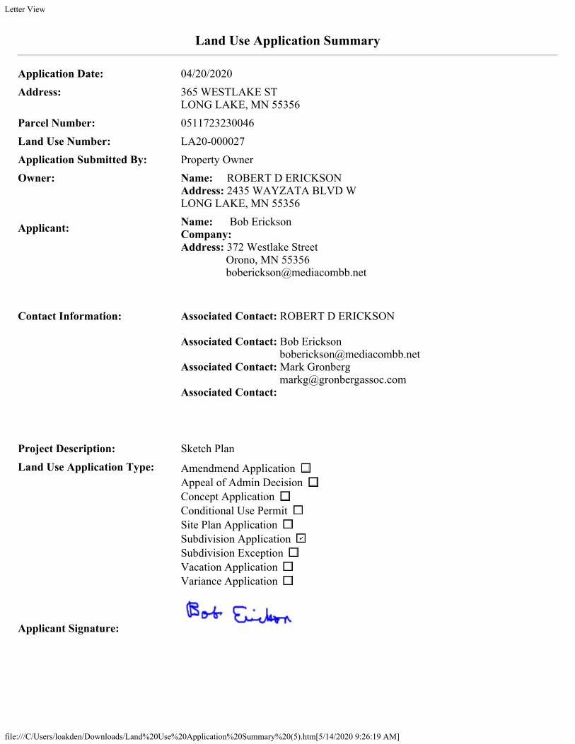
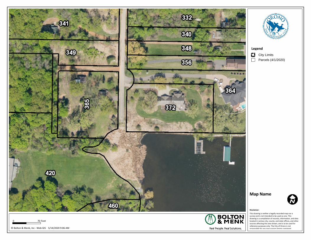
To: Chair Ressler and Planning Commission Members Dustin Rief, City Administrator From: Laura Oakden, Planner Date: May 18, 2020 Subject: #LA20-000027, Bob Erikson, 365 Westlake Street, Sketch Plan Background The applicant represents 365 Westlake Street and resides in the adjacent property at 372 Westlake Street. 365 Westlake is shown to have frontage on lake Minnetonka, has right of way on three sides and one abutting neighbor (420 Tonkawa Road). The lot currently has a structure on the property. The parcel is located in LR-1A District which has a minimum requirement of 200 feet at the lake and 2 acres in size. According to Hennepin County, 365 Westlake is 1.13 acres/49,222 sq. ft. in size and roughly 58’ wide at the shoreline making the lot substandard for the district. The lot looks to be wooded with a sloped grade towards Lake Minnetonka. Hennepin County indicates there may be wetlands located on the East side of the property near Westlake Right- of-Way. Proposal The applicant proposes a number of actions, resulting in a plan for 365 Westlake. The actions include: 1. Vacation of Westlake south of the current cul-de-sac 2. Provision of right of way to complete the cul-de-sac 3. Incorporating the vacated Westlake into 365 Westlake 4. Provision of easement necessary to protect public purpose (water, sewer, sanitary sewer) 5. Provision of a cash donation for ‘residential purposes’ Application Summary: The applicant is requesting informal feedback on the proposed sketch plan for 365 Westlake Street Staff Recommendation: While no formal action is required, this memo will serve as a foundation for the Commissions discussion with the applicant to bring to light potential issues to be addressed prior to submission of a formal application. Planning Department Staff recommends the Commission provide feedback.
Transcript
To: Chair Ressler and Planning Commission Members Dustin Rief, City Administrator From: Laura Oakden, Planner Date: May 18, 2020 Subject: #LA20-000027, Bob Erikson, 365 Westlake Street, Sketch Plan
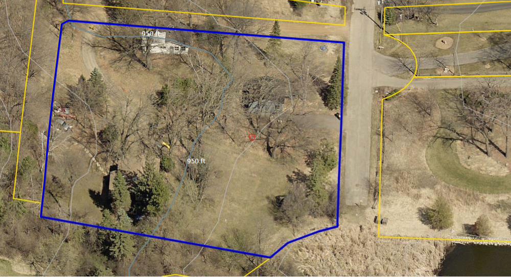
Background The applicant represents 365 Westlake Street and resides in the adjacent property at 372 Westlake Street. 365 Westlake is shown to have frontage on lake Minnetonka, has right of way on three sides and one abutting neighbor (420 Tonkawa Road). The lot currently has a structure on the property. The parcel is located in LR-1A District which has a minimum requirement of 200 feet at the lake and 2 acres in size. According to Hennepin County, 365 Westlake is 1.13 acres/49,222 sq. ft. in size and roughly 58’ wide at the shoreline making the lot substandard for the district. The lot looks to be wooded with a sloped grade towards Lake Minnetonka. Hennepin County indicates there may be wetlands located on the East side of the property near Westlake Right-of-Way. Proposal The applicant proposes a number of actions, resulting in a plan for 365 Westlake. The actions include:
1. Vacation of Westlake south of the current cul-de-sac 2. Provision of right of way to complete the cul-de-sac 3. Incorporating the vacated Westlake into 365 Westlake 4. Provision of easement necessary to protect public purpose (water, sewer, sanitary
sewer) 5. Provision of a cash donation for ‘residential purposes’
Application Summary: The applicant is requesting informal feedback on the proposed sketch plan for 365 Westlake Street Staff Recommendation: While no formal action is required, this memo will serve as a foundation for the Commissions discussion with the applicant to bring to light potential issues to be addressed prior to submission of a formal application. Planning Department Staff recommends the Commission provide feedback.
FILE # LA20-000027 May 18, 2020
Page 2 of 3
The applicant notes in the narrative they are open to provided easements for utility infrastructure. They also indicated they would like to provide a cash donation to the city for ‘recreational purposes’. Planning Staff Analysis Hennepin County determines how vacated roads are distributed, the Council must determine that there is no public purpose behind the land. With the vacation of Westlake, each adjacent parcel would presumably receive ½ of the right of way, or about 2,350 sq. ft. to each. The applicant is proposing to add the entire vacated road to the 365 Westlake parcel. The current lot in substandard in area (1.13 acres or 49,222 sq. ft.) and width (58’). The applicant indicated they would provide land for a cul-de-sac roughly (2,127sq.ft), removing land from the parcel. The table below summarizes the changes LOT ANALYSIS WORKSHEET
365 Westlake Action Area Existing Lot 1.13 acres/ 49,222 sq.ft Cul-de-sac Subtracted from lot area -2,127 sq.ft Vacated portion Westlake ROW added to Lot area + 4700 sq.ft Proposed Lot Size 1.19 acres/ 51,795 sq.ft
The property is redistributing land and still substandard in the LR-1A district (2acre/200’ width) Cul-da-sac: The city recognizes a benefit to provide a turn-around on Westlake Street. The applicant’s submitted survey does identify this cul-de-sac area, but clarification is needed from the applicant on how the land would be dedicated via right-of-way or easement. Staff recommends the cul-de-sac be dedicated right-of-way to allow for public improvement and accessibility as part of a final plat. Vacate Lake Access Point: The Comprehensive Plan discusses lake access points as both a function of transportation and parks. Current lake access points within the City are identified in Exhibit ___ MAP and described in further detail on Exhibit __ TABLE. This lake access is point 14 within the Lake Access table and map and is identified as pedestrian access. There are 5 total lake access points identified on Stubbs bay, with no other access points in this neighborhood. The relevant sections of the comprehensive plan are included. In the development of the 2040 Comprehensive Plan, the Council did soften its posture on responding to lake accesses vacations, allowing review of requests. The DNR must review any request for vacation of a lake access point. Currently there are three city improvements within Westlake Street. Please refer to the City Engineers Comments for further analysis.
1. Pavement. There is an improved road through the proposed vacated area. 2. Sewer. There is currently sanitary sewer infrastructure within the right of way 3. Drainage. Surface water currently flows through the property, to Lake Minnetonka.
Engineer Comments
1. The proposed right of way (ROW) to be vacated currently serves as a public purpose in many ways, drainage & Sanitary Sewer, and should therefore not be vacated.
FILE # LA20-000027 May 18, 2020
Page 3 of 3
2. The provision of ROW for a cul-de-sac would provide and an opportunity for a future turn around to be constructed.
3. If land is needed to make up for any land set aside for the Cul-de-sac ROW, the alleyway ROW to the west of the proposed lot could be considered for vacation as it does not currently serve a public purpose.
4. The ROW leading to the lake is a lack access point. Prior to considering it for vacation, the Parks Commission should be consulted. Although not currently improved for recreation it could be in the future such as for winter access or the provision of a small fishing dock.
Public Comments To date, no public comments have been received. Issues for Consideration
1. Does the Commission and Council support platting a substandard property? 2. Does the Commission support the Vacating the right of way with current public
improvements and lake access. 3. Is the Planning Commission comfortable with the proposed plan?
Planning Staff Recommendation Planning Staff requests feedback. List of Exhibits Exhibit A. Application Summary Exhibit B. Subject Parcels Pictures Exhibit C. Sketch Plan Exhibit D. Narrative Exhibit E. GIS Infrastructure Map Exhibit F. Hillside Plat Exhibit G. Lake Access Map Exhibit H. Park: Goals and Policies Exhibit I. Lake Access Table References:
a. Comprehensive Plan 4A Transportation b. Comprehensive Plan 4E Parks
Application Date: 04/20/2020Address: 365 WESTLAKE ST
LONG LAKE, MN 55356Parcel Number: 0511723230046Land Use Number: LA20-000027Application Submitted By: Property OwnerOwner: Name: ROBERT D ERICKSON
Address: 2435 WAYZATA BLVD W LONG LAKE, MN 55356
Applicant: Name: Bob EricksonCompany: Address: 372 Westlake Street Orono, MN 55356 [email protected]
Contact Information: Associated Contact: ROBERT D ERICKSON Associated Contact: Bob Erickson [email protected] Contact: Mark Gronberg [email protected] Contact:
Project Description: Sketch PlanLand Use Application Type: Amendmend Application
Appeal of Admin Decision Concept Application Conditional Use Permit Site Plan Application Subdivision Application Subdivision Exception Vacation Application Variance Application
This drawing is neither a legally recorded map nor a survey and is not intended to be used as one. This drawing is a compilation of records, information, and data located in various city, county, and state offices, and other sources affecting the area shown, and is to be used for reference purposes only. The City of Orono is not responsible for any inaccuracies herein contained.
This drawing is neither a legally recorded map nor a survey and is not intended to be used as one. This drawing is a compilation of records, information, and data located in various city, county, and state offices, and other sources affecting the area shown, and is to be used for reference purposes only. The City of Orono is not responsible for any inaccuracies herein contained.
Disclaimer:
5/14/2020 9:06 AM
70 Feet
City Limits
Parcels (4/1/2020)
My goal is to combine the land at 365 Westlake St. (PID # 05-117-23 23 0046) with the south 127 feet or so of Westlake St. while dedicating land for a new cul de sac. I believe this could be accomplished by the approval of a single lot replat. The new cul de sac would be centered at the same point that was used in 1998 when I received a lot line rearrangement on the east side of Westlake St for my house at 372 and another lot at 364. At that time the City agreed to a 40-foot radius on the east side of the street. The new additional cul de sac area shows a 50-foot radius. The new portion will be big enough to provide on street parking. Since the area vacated is about .03 acres larger than the amount dedicated, the new lot, at 1.16 A. will be slightly less non-conforming in the 2-acre zone. In addition, I am offering to pay a $ 100,000 park dedication fee and to remove 2,286 square feet of pavement hardcover from the south end of the street. 59% of this hardcover is within the 75-foot setback area. I have an updated survey that shows that two of the original three houses on the site that were removed last year. Attached is an area map of Westlake Street, and a detail map showing dimensions of the proposed cul de sac. The existing "lake access" does not actually provide any access to the lake, because the lakeshore has been completely overgrown with aquatic vegetation for a number of years. It is never used because it is not possible to do so. Two separate portions of the east-west alley on the east side of Westlake were vacated years ago, the most recent in the 1990’s. Further, almost every house on the street has their own lakeshore, so they would not have a use for public access, even if it was usable. Easements can be provided for drainage and sanitary sewer maintenance. At the same time, having a dead-end street of substandard width with no cul de sac causes frequent problems for delivery trucks, garbage haulers, and lawn services. Fortunately, there have not been any fires or medical emergencies, because Westlake Street is not prepared for them. These problems intensify when anyone parks in the street, which is barely wide enough for two-way traffic. When complete, the neighborhood will be well served with improved water quality, on street parking, and an appropriate terminal for the safe and convenient reversal of traffic movement. The City will also benefit from a contribution for recreational purposes. I look forward to seeing this neighborhood improvement move forward.
This drawing is neither a legally recorded map nor a survey and is not intended to be used as one. This drawing is a compilation of records, information, and data located in various city, county, and state offices, and other sources affecting the area shown, and is to be used for reference purposes only. The City of Orono is not responsible for any inaccuracies herein contained.
Disclaimer:
5/14/2020 8:59 AM
70 Feet
Sanitary Manhole
Sanitary Manhole (Medina)
Sanitary Manhole (MCES)
Sanitary Lift Station
Sanitary Lift Station (Medina)
Sanitary Lift Station (MCES)
Sanitary Clean Out
Sanitary Termination Valve
Sanitary Isolation Valve
Sanitary Grinder Station
Sanitary Gate Valve
Sanitary Gate Valve (Medina)
Sanitary Flushing Valve
Sanitary Curbstop
Air Release Manhole
Sanitary Pipe
Sanitary Pipe (MCES)
Sanitary Service Pipe
Sanitary Forcemain
Sanitary Forcemain (Medina)
Sanitary Forcemain (MCES)
Storm Manhole
Storm Culvert
Inlet
Outlet
Storm Control Structure
Catch Basin
Storm Culvert Pipe
Storm Pipe
Storm Drain Tile
Storm Open Waterway
City Limits
Parcels (4/1/2020)
Storm Ponds
#*
#*
#*#*
#*
#*#* #*
#*
#*
#*#*#*
#*
#*
#*
#*
#*#*
#*#*
#*#*#*#*
#*
#*#*#*#*
#*
#*#*
#*
#*
#*
#*
#*
#*
#*
#*
#*#*#*
#*#*
#*#*#*#*
#*
Cook'sBay
SpringParkBay
Carman'sBay
HarrisonBay
WestArm
MaxwellBay
NorthArm
ForestLake
Jenning'sBay
StubbsBay
LafayetteBay
WayzataBayTanager
Lake
LakeClassen
DickeyLake
LongLake
LydiardLake
MooneyLake
CascoPoint
CrystalBay Bohns
Point
SmithBay
LakeMinnetonka
BrownsBay
BrackettsPoint
FrenchMarsh
KatrinaLake
DutchLake
LangdonLake
Long
Lake Cre ek
Minnehaha Creek
Painter Creek
Minnehaha Creek
Painter C r eek
GVWX15
GVWX16GVWX15
GVWX112
GVWX84GVWX135
GVWX101
GVWX110
GVWX146
GVWX125
GVWX5
GVWX151GVWX19
GVWX6
GVWX19GVWX101
GVWX6
GVWX51
%&'(394
%&'(494
)*12
)*12
?@A@7
ST26
ST201
Minnetonka Dr
Minnetonka Blvd
Woo
dhill
Roa d
Three Points B lvd
Lake St Extension
Or chard Road
Highland AveLynwood Blvd
P e avey
Road
6th Ave N
Fern
dale
Road
N
Coun
ty Ro
ad 19
N
StarkeyRoad
Rutledge Road
22ndAve N
Comm
erce
Blvd
Highway 12 E
6thAve N
Tonk
awoo
dRoa
d
Coun
tyRo
a d1 0
1
Inter
state
494
Highwood Dr
N Arm
Dr
Willis
ton R
oad
Azure Road
Brow
nRo a
d N
Shoreline Dr
Fernda le Road W
19th Ave N
Manor Road
Oak land RoadFernda
le
Ro adS Interstate 394
Highway 7
8th Ave N
N Sh ore DrStone Road
Rice St E
Wate rtown RoadGleason Lake Dr
Carls
onPkwy N
21st Ave N
3rd Ave N
Wayzata Blvd E
Willo
w Dr
N
Ba yside Road
Wayzata BlvdW
Kelley P kwy
Lakeview Ave
County Road 151
Gray s Bay Bl v d
Ranc
hview
Ln N
Lake Ave
Daniels St
Maplewood Road
Lake St E
Pkwy
4th Ave N
A v o nDr
Devon Dr
P ark Ave
S Ln
Orchard Ln
Shorewood Ln
Ste e
leSt
Park St E
Grand Ave
Northern Ave
Vine St
Dove
Ln
20th Ave N
Coun
ty Ro
ad 83
9th Ave N
Ridgeview Dr E
Old C
rysta
l Bay
Roa
d N
Fox St
Old Long Lake Road
Minne hah a Pl
Day PlHeri
tage Ln
R ai n bow
Dr
L yric Ave
W Branch Road
Rin ge r Road
Hunte
r Dr
Wayzata Blvd
Spring Hil
l Road
Tem ple Dr
Arcola Ln
Coun
ty Road 15
Crown Dr
East w o odRo
a d
5 th Ave N
ChimoW
Wild
hurst
Trl
Moline Road
Tama
rack
DrWayzata Blvd W
Togo RoadW Arm Dr
Regen
tsWalk
Gale
Road
Pe avey Ln
Cy gnet
Pl
Drake Dr
Turner Road
Linwo
od Road
Kelly Ave
McGinty Road W
Manitou
Road
Wilshire Blvd
Coun
tyRo
ad10
1
Shadywood Road
Gl eason LakeRoad
Cros
byRo
ad
Harb
orLn
N
Ba rtle tt Blvd
High
land R
oad
Coun
ty Ro
ad 19
Old C
rysta
l Bay
Roa
d S
Vine
Hill R
oad Can t e rbury Dr
Donald Dr
Linn
erRo
ad
Dunk
irk Ln
N
WillowDr S
Leaf
St
Holdr
idge Dr
Tonkawa Road
McCulley Road
CountyRoad110 N
Victor
ia St
Brow
n Ro a
dS
Isla n d View
Dr
Eastman Ln
Niag
ara Ln
N
Edgew aterDr
Vicks
burg
Ln N
W
P oint
Road
L a fayette Roa d
Bush
away
Road
Woo
dhill Roa d
Lakev iewPkwy
Lero
y St
Stub
bs B
ay R
oad N
Susse x Dr
Troy LnN
Hil l si de D r W
18th Ave N
2
1
34
5
6 7 8
9
10
11121314
1516
1718
1920212223
24
2526
27 2829
30 3132
33
34
35
36
3738
3940
41
AB
CD
EFG
HI
1A
Map D
ocum
ent: \
\Arcs
erver1
\GIS\
ORNO
\C13
1148
14\ES
RI\M
aps\L
andU
se\O
RNO_
4E-B
_Lak
eAcc
essP
oints_
11x1
7L.m
xd |
Date
Save
d: 11
/9/20
18 3:
27:44
PM
2040 Comprehensive PlanOrono, MN November 2018
Lake Access Points
Legend
City Limits
2040 MUSA
Lakes & Ponds
Rivers & Streams0 3,500
FeetSource: Met. Council, City of Orono,
Hennepin County, MnDOT
!I Lake Access Points#*
Lake AccessPoints
Map 4E-2
CMP Part 4E. Parks, Trails, and Open Spaces
City of Orono Community Management Plan 2020-2040 Part 4E, Page 6
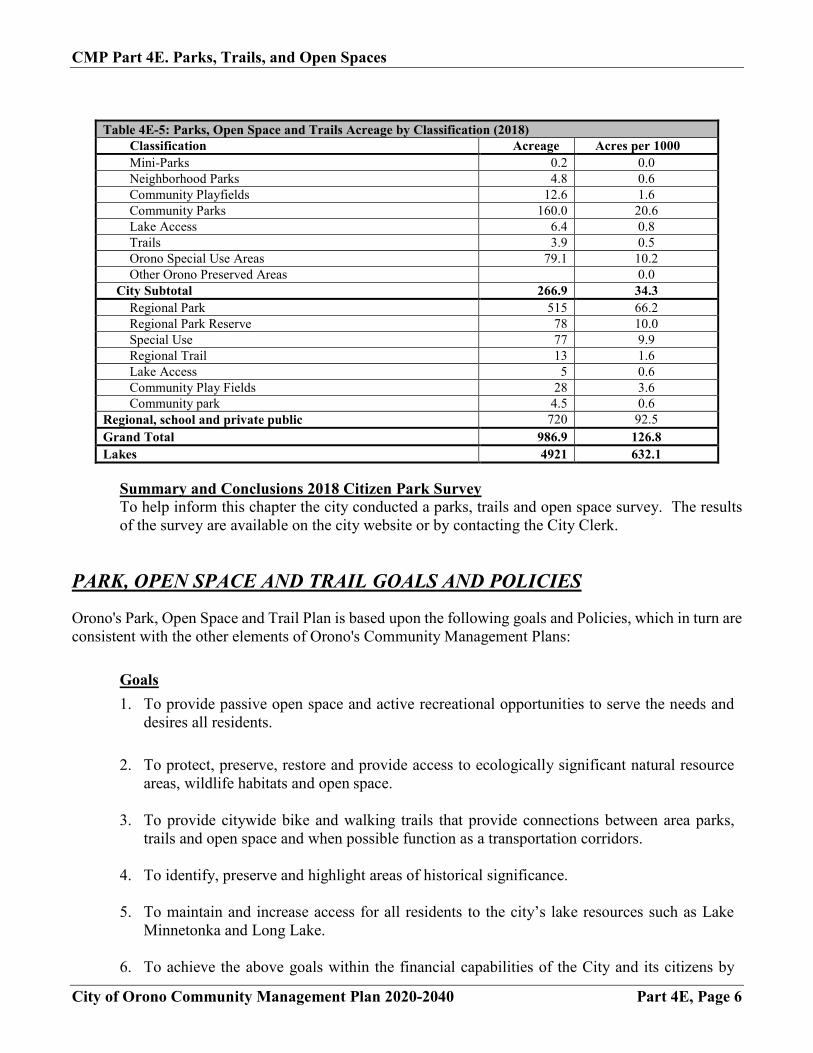
Table 4E-5: Parks, Open Space and Trails Acreage by Classification (2018)
Classification Acreage Acres per 1000 Mini-Parks 0.2 0.0 Neighborhood Parks 4.8 0.6 Community Playfields 12.6 1.6 Community Parks 160.0 20.6 Lake Access 6.4 0.8 Trails 3.9 0.5 Orono Special Use Areas 79.1 10.2 Other Orono Preserved Areas 0.0
City Subtotal 266.9 34.3 Regional Park 515 66.2 Regional Park Reserve 78 10.0 Special Use 77 9.9 Regional Trail 13 1.6 Lake Access 5 0.6 Community Play Fields 28 3.6 Community park 4.5 0.6
Regional, school and private public 720 92.5 Grand Total 986.9 126.8 Lakes 4921 632.1
Summary and Conclusions 2018 Citizen Park Survey To help inform this chapter the city conducted a parks, trails and open space survey. The results of the survey are available on the city website or by contacting the City Clerk.
PARK, OPEN SPACE AND TRAIL GOALS AND POLICIES Orono's Park, Open Space and Trail Plan is based upon the following goals and Policies, which in turn are consistent with the other elements of Orono's Community Management Plans:
Goals 1. To provide passive open space and active recreational opportunities to serve the needs and
desires all residents.
2. To protect, preserve, restore and provide access to ecologically significant natural resource areas, wildlife habitats and open space.
3. To provide citywide bike and walking trails that provide connections between area parks,
trails and open space and when possible function as a transportation corridors.
4. To identify, preserve and highlight areas of historical significance.
5. To maintain and increase access for all residents to the city’s lake resources such as Lake Minnetonka and Long Lake.
6. To achieve the above goals within the financial capabilities of the City and its citizens by
CMP Part 4E. Parks, Trails, and Open Spaces
City of Orono Community Management Plan 2020-2040 Part 4E, Page 7
developing fiscal and management policies that support maintenance, development and acquisition of parks and open spaces.
Policies 1. The city will maintain a Park Commission of appointed residents to continually assess and
evaluate the current parks, trails and open spaces within Orono. (Supports goals 1, 2, 3, 4, 5, 6)
2. The city will actively encourage civic involvement in developing and maintaining Orono’s
parks and open spaces through programs such as adopt a parks and park clean up days. (Supports goals 1, 2, 6)
3. The City will cooperate and actively work with public and private organizations to provide
additional opportunities for recreation and open space that complement existing municipal, regional and private facilities. (1, 2, 3, 4, 5, 6)
4. Orono will require land developers to provide for recreational space to serve all new
subdivisions. New developments that results in increased land use density will be required to include public dedication of lands necessary for additional parks, playgrounds, bike-hike trails and open space or will be required to contribute funds for the municipal purchase, of such lands or improvement of existing recreation facilities proportionate to the cumulative effect of such density increase. (Supports goals 1, 2, 3, 6)
5. Orono will encourage the preservation and protection of natural recreational and open space
amenities including lakes, marshland, wetlands, and natural woodlands on private lands though open space through conservation easements, private donations, land trusts and other preservation methods that allow the private sector to play role in preservation of open spaces. (Supports goals 2, 6)
6. Orono will coordinate with other jurisdictions, agencies and non-profit organizations in the
provision of sufficient active recreation facilities and programs to meet the needs of the community. Orono will actively encourage all school districts to coordinate their programs and facilities and to open them to the public whenever feasible. Orono will actively support and cooperate with the Orono and Mound-Westonka School Districts in their community service recreation programs. The City will encourage planning for organized team sports on a community/sub-regional basis. Orono will work with public or non-profit groups to fund the acquisition and development of recreational and open space lands and facilities. (Supports Goals 1, 4, 5)
7. Orono will strive toward connectivity between the various park and open space facilities. The
interrelationships between neighborhood parks, conservation areas and the rest of the park system should be strengthened through the proper location and use of green ways, trails, underpasses and overpasses. Trail connections should be provided to neighborhood parks to enable pedestrian access. Trail corridors/ easements will be incorporated at the edge of subdivisions and adjacent to major roadways. (Supports goal 3)
8. Orono will acquire additional public open space parcels as opportunities arise. The priority for
CMP Part 4E. Parks, Trails, and Open Spaces
City of Orono Community Management Plan 2020-2040 Part 4E, Page 8
any acquisitions will be for ecologically significant lands that abut existing park land, land that provides improved access to existing parkland and trails or land that facilitates the development of the planned trail system. (Supports goals 2, 5, 6)
9. The City’s park dedication fund will be used for purchase of additional park land and/or forimprovement of existing park land. Consistent with Minnesota Statutes, this fund will not beused for park maintenance or recreation operating expense. (Supports goal 6)
10. Where possible, recreational facilities will be designed to be barrier-free so that handicappedcitizens have reasonable access to facilities. Orono will ensure that select new parks areconstructed with accessibility in mind and to incorporate Americans with Disabilities Act(ADA) design standards with projects to upgrade existing parks. (Supports goals 1, 3, 5)
11. Orono will maintain Lake Access for all residents. With shore land abutting a dozen separatebays in Lake Minnetonka, Orono has a commitment to maintaining access via the dedicatedaccess corridors. It is the City’s intent to permanently retain for public use all existing lakeaccess corridors and fire lanes, regardless of the current level of use or maintenance. (Supportsgoal 5) To this end, the City will follow these policies: Requests for vacation of dedicated lake access right of ways will be evaluated carefully, in
particular where equal or better lake accesses are not available nearby. The City willidentify and take necessary action to preserve the public’s right to use of any such accesseswhich exist but which may not have been formally dedicated.
The City will endeavor to work with property owners adjacent to lake access corridors toensure that both the rights of the public and the rights of the private landowner are upheld.
12. The city will conduct a periodic (10 year cycle) park usage and needs community wide surveyto determine if residents’ needs are being met. (Supports goal 1)
13. The city will review the existing park and facilities conditions to identify needed maintenanceupgrades and replacements.
14. The city will provide sufficient funding for the administration and maintenance of the existingparks, trials and open space system as part of the regular City budget levy. Other sources ofpark funding such as development park fees, grants, support from local organizations, privatedonations, will be used for acquisitions, capital improvements and major renovations.(Supports goal 6)
CMP Part 4A. Transportation Plan
City of Orono Community Management Plan 2020-2040 Part 4A, Page 17
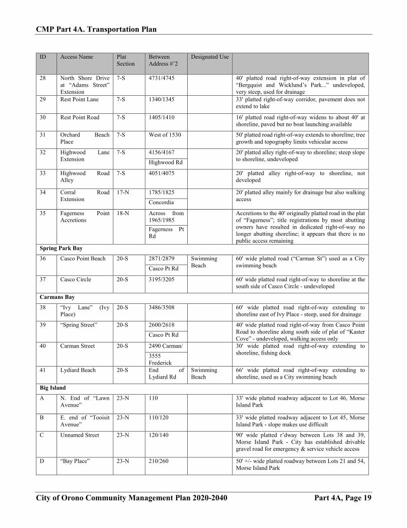
Table 4A-9: City of Orono Lake Minnetonka Access Points - Designated Use and Current S ID Access Name
or Street Name
Plat Section
Between Address #s
Designated Use
UPDATED 4-24-2018
# Notes Brown’s Bay (Lower Lake)
1 End of Orono Lane 2-S 1355/1385 Not open for public use; plat map indicates questionable abutment of shoreline
-- Shoreline Drive - “Molly’s Corner” (Outlot A, Dragonfly Hill)
2-S Across from 1410 Shoreline
Shore Fishing Hennepin County provides an informal parking area and trashcans at this wide spot along Shoreline Drive; popular fishing spot; winter vehicular access feasible. Fire Boat dockage
Smith Bay (Lower Lake)
2 Shoreline Drive at Spates
10-S Adj to 1955 Winter Only Winter vehicular access allowed.
3 North Shore Drive at Shoreline Drive
10-S Tracts S&U, RLS 192; these tracts are on the steep slope adjacent to Shoreline Drive; due to slope and safety issues this access point is not open for public use
Crystal Bay
-- North Shore Drive 9-S 2605/2655 No longer a public access (“Town Road”)
4 North Shore Drive at Baldur Park Road
8-S 3498/3510 Winter Only 30' wide platted road right-of-way
-- North Shore Drive east of Shadywood Road
17-N 3685/3705 33' wide eastward extension of North Shore Drive (Hennepin County jurisdiction)
5 Shadywood Road at Sunset Dr
17-N 1998/2000 15.2' wide platted alley - closely abutting homes on either side
6 Crystal Bay Road (West end)
17-S Adj to 2264 Shadywood
66' wide platted road extending to lakeshore; City also owns 4 adjacent tiny lakeshore parcels to the east for an additional 200' of shoreline, over which a number of inland private parcels claim deeded access rights for “boating and bathing”… status currently under discussion
7 Crystal Bay Road (Relocated extension of Bayview Place in plat of “Wallace’s Addition...”)
17-S 3405/3415 20' relocated alley from Railroad property to shoreline; potential lake access from railway corridor. The only known documentation is Doc. #507616 deed filed Nov. 10, 1908 from Wallace et al to Priebe which states that the 20' strip is “heretofore taken for street purposes” and notes that the platted alley between Lots 18 and 19 was vacated by the District Court.
8 Crystal Bay Road (Platted extension of Hillside Place)
17-S 3339/3345 25' wide platted roadway; contains municipal sewer lines, potential access from neighborhood and Railroad/Trail corridor to lakeshore
Maxwell Bay
9 Gibbs Landing - Fox St.
4-S Adj to 3125 Pedestrian year-round, vehicles winter only
Tax records show access as Outlot A, owned by owner of 3125, City has easement over Outlot, City maintains access
CMP Part 4A. Transportation Plan
City of Orono Community Management Plan 2020-2040 Part 4A, Page 18
Stubbs Bay
ID Access Name Plat Section
Between Address #’s
Designated Use
10 Eastlake Street 5-N 3424/3465 Winter Only 30' platted road gated March 1 - Dec. 1
11 Bayside Rd. at Stubbs Bay Rd.
5-N 3580/3640 Fishing Dock 33' platted road (“Oak Street” in plat of “Bay View Park”) Also used for winter access by snowmobiles off Luce Line
12 Bayside Rd 5-N Across from 3640, 3700,
NA Two 60' platted roads and one 65' platted road to the Lake (Park, Spring, and Maple Streets in plat of Bay View Park; and Theresa St. in plat of Ottoville on Lake Minnetonka). These potential access points are not opened for public use.
3750 Bayside
13 Bayside Rd. 5-N West side of 3775 Bayside
NA 30' realigned platted road (Realigned “Lake Street” in the plat of Ottoville on Lake Minnetonka) (See street file 3775 Bayside). Not opened for public use.
14 Westlake Street 5-N 372/389 30' platted road right-of-way extending to lakeshore; walking access only.
North Arm Bay
15 Park Lane 6-S 607/649 Fishing Dock 60' wide platted road, paved to shoreline - usable for boat launch but there is no parking available
16 Oak Street 6-S Adj to 4119 30' wide platted road, not developed, steep slopes and ravine limit use
17 Baldur Park Road 8-S Across from 1384/1392
NW end of platted developed road as it extends to shoreline
18 Oak Place (Platted road in plat of “Crystal Bay View”)
8-S 3768/3818 40' wide platted undeveloped road extending from North Shore Drive across platted Cherry Ave to shoreline; mostly wetland or under water North Shore
Dr
19 Sandy Beach (Extension of Maple Place)
8-S 3898/3908 Swimming Beach
60' wide platted roadway used for City beach
Cherry Ave
20 Grant Street 8-S 1310 Spruce/ 50' wide platted road, undeveloped
1330 Cherry Pl
21 Spruce Place 8-S 1250/1260 40' wide (remaining after partial vacation) platted roadway, undeveloped
22 Loma Linda Avenue 8-N 1098/1130 Fishing Dock 40' wide platted road; also useful for vehicular access
Forest Lake
23 Forest Lake Landing 7-N 4415/4440 60' wide platted road right-of-way , access not developed, walking use only
24 Elmwood Avenue 7-N South of 1199 20' wide platted road/alley undeveloped right-of-way leading to shoreline
25 “Summit Avenue” (Extension of Elmwood Avenue)
7-S 1067/1101 50' wide platted road undeveloped right-of-way to shoreline
26 “Buff Street” 7-S West side of 1453 Park Dr
50' wide platted road right-of-way to shoreline, not developed
West Arm Bay
27 North Shore Drive west end (adjacent to Orono/M’trista border)
7-S “4795" 33' platted right-of-way corridor extension of Co. Rd. 19 plus tax-forfeited Lot 10, Block 6, “Bergquist and Wicklund’s Park...”; undeveloped corridor primarily for drainage purposes due to very steep slopes
Shoreline
CMP Part 4A. Transportation Plan
City of Orono Community Management Plan 2020-2040 Part 4A, Page 19
ID Access Name Plat Section
Between Address #’2
Designated Use
28 North Shore Drive at “Adams Street” Extension
7-S 4731/4745 40' platted road right-of-way extension in plat of “Bergquist and Wicklund’s Park...” undeveloped, very steep, used for drainage
29 Rest Point Lane 7-S 1340/1345 33' platted right-of-way corridor, pavement does not extend to lake
30 Rest Point Road 7-S 1405/1410 16' platted road right-of-way widens to about 40' at shoreline, paved but no boat launching available
31 Orchard Beach Place
7-S West of 1530 50' platted road right-of-way extends to shoreline; tree growth and topography limits vehicular access
32 Highwood Lane Extension
7-S 4156/4167 20' platted alley right-of-way to shoreline; steep slope to shoreline, undeveloped Highwood Rd
33 Highwood Road Alley
7-S 4051/4075 20' platted alley right-of-way to shoreline, not developed
34 Corral Road Extension
17-N 1785/1825 20' platted alley mainly for drainage but also walking access Concordia
35 Fagerness Point Accretions
18-N Across from 1965/1985
Accretions to the 40' originally platted road in the plat of “Fagerness”; title registrations by most abutting owners have resulted in dedicated right-of-way no longer abutting shoreline; it appears that there is no public access remaining
Fagerness Pt Rd
Spring Park Bay
36 Casco Point Beach 20-S 2871/2879 Swimming Beach
60' wide platted road (“Carman St”) used as a City swimming beach Casco Pt Rd
37 Casco Circle 20-S 3195/3205 60' wide platted road right-of-way to shoreline at the south side of Casco Circle - undeveloped
Carmans Bay
38 “Ivy Lane” (Ivy Place)
20-S 3486/3508 60' wide platted road right-of-way extending to shoreline east of Ivy Place - steep, used for drainage
39 “Spring Street” 20-S 2600/2618 40' wide platted road right-of-way from Casco Point Road to shoreline along south side of plat of “Kaster Cove” - undeveloped, walking access only Casco Pt Rd
40 Carman Street 20-S 2490 Carman/ 30' wide platted road right-of-way extending to shoreline, fishing dock 3555
Frederick 41 Lydiard Beach 20-S End of
Lydiard Rd Swimming Beach
66' wide platted road right-of-way extending to shoreline, used as a City swimming beach
Big Island
A N. End of “Lawn Avenue”
23-N 110 33' wide platted roadway adjacent to Lot 46, Morse Island Park
B E. end of “Tooisit Avenue”
23-N 110/120 33' wide platted roadway adjacent to Lot 45, Morse Island Park - slope makes use difficult
C Unnamed Street 23-N 120/140 90' wide platted r’dway between Lots 38 and 39, Morse Island Park - City has established drivable gravel road for emergency & service vehicle access
D “Bay Place” 23-N 210/260 50' +/- wide platted roadway between Lots 21 and 54, Morse Island Park
CMP Part 4A. Transportation Plan
City of Orono Community Management Plan 2020-2040 Part 4A, Page 20
ID Access Name Plat Section
Between Address #’s
Designated Use
E “Meadow Lane East Extended”
23-S 280/290 20' wide platted roadway between Lots 59 and 60, Morse Island Park - steep slope makes use difficult
F “Meta-Comet Avenue South”
23-S 340 33' wide platted roadway between Lot F Morse Island Park and Lot 3, Morse Island Park 2nd Addition
G “Massasolt Avenue West End”
23-S 440/450 33' wide platted roadway between Lot 1, Morse Island Park and Lot 1, Scrivers subdivision of Lot E, Morse Island Park - steep slope
H “Meadow Lane Alley”
23-S 450/460 16' platted alley between Lots 5 and 6, Morse Island Park - drivable for emergency and service vehicles
I “Pleasant View Street”
22-S 570/600 30' platted roadway between Lot 9, Pleasant View Lake Minnetonka and Lot 3, Island Pointe
TRANSIT Orono is categorized as a Transit Market Area IV. Transit Market Area IV has lower concentrations of population and employment and a higher rate of auto ownership. It is primarily composed of Suburban Edge and Emerging Suburban Edge communities. This market can support peak-period express bus services if a sufficient concentration of commuters likely to use transit service is located along a corridor. The low-density development and suburban form of development presents challenges to fixed-route transit. General public dial-a-ride services are appropriate in Market Area IV. The three primary routes serving Orono are Express Route 645 and 677, which provide express service to downtown from the Mound, Navarre and Wayzata commercial areas along County Road 15, and Express Route 674 which provides similar express service to western and central Orono, Long Lake and Wayzata. The TPP’s Transit Investment Plan does not show any transitway investments planned for Orono in the Current Revenue Scenario. (See Map 4A-7).To expand the reach of these fixed routes, the City will promote dial a ride services throughout the city. The Transportation Policy Plan discusses the expansion of Transit Advantages, though none are expressly identified within Orono boundaries. Given the limited right of way and the growing congestion of County Road 15 through Navarre, improvements and programs to expand Transit Advantage in the area should be closely considered.
FREIGHT Freight transportation in Orono is primarily served by a Burlington Northern Santa Fe (BNSF) rail line parallel to US 12. There are no freight facilities within Orono. The BNSF rail line does not cross any roadways within the City. There are no large freight traffic generators within the City. Most truck and rail traffic is passing through Orono on trips to, from, and through the Twin Cities. Heavy truck traffic is for the most part constrained to roads under Hennepin County and State Jurisdiction. (See Map 4A-8) The development of the lake areas in Orono as seasonal recreational in the late 1800s early 1900’s established many of the transportation patterns found throughout the community. In the lake areas, this pattern led to roads that are substandard to today’s standards. Local residential roads are not designed for heavy freight movement. As the City expands its maintenance program, improvements to turning radii, width, and stormwater retention are considered. There are no known locations where truck access is not available.