28
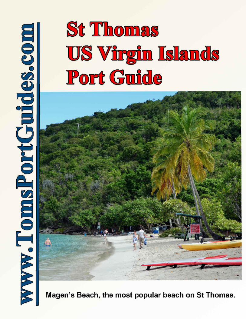

Toms St Thomas & St John US Virgin Islands Cruise Port Guide27 Pages & 18 Maps: 1) Walking tour of Charlotte Amalie, 2) Havensight & Crown Bay docks incl. stores, restaurants, 3) Ferry boat docks and travel routes, 4) Maps and descriptions of all beaches, 5) a taxi tour of St John with photos and descriptions of tourist sites, and 6) Travel by Ferry to St John with maps and descriptions of popular tourist sites and hiking trails on St John.
Why the Virgin Islands Are Popular• It's a beautiful area with many islands, hills, gorgeous beaches, coves, parks, etc.• Crystal clear water and coral reefs are inviting for all sorts of activities e. g. swimming, snorkeling, scuba
diving, kayaks, small sail boats, boat tours, year round fishing and boating, etc.• Boat charters - my wife and I chartered a 42-foot sail boat for a week from Moorings in Road Town, Tortola to
sail with our high school age sons. It was our best, most memorable family vacation. • Pleasant climate and near constant trade winds make it comfortable to wear shorts and sandals all year.• Excellent restaurants, hotels, resorts, and shopping. St Thomas is one of the best places for US residents
to shop due to great prices, no sales tax, and $ 1600 per person exemption from Customs Declaration.• Transportation is good. There are US airports in St Thomas and St Croix and two cruise ports in St Thomas.
Ferry boats connect the islands. Taxi service is good at the cruise ports, airports, in the major shoppingareas, and in the major towns.
St Thomas is 39 miles due east of Puerto Rico. The division between US and British islands is shown as a whiteline on the map below.
There are many small islands. The largest islands are Culebra, Vieques, St Thomas, St John and St Croix in theUS Virgin Islands and Tortola, Jost Van Dyke, Virgin Gorda, and Anegada in the British Virgin Islands.
CAVEATInformation contained herein is believed to be accurate. PLEASE verify the information you use for your travelplans. Opinions expressed are my own. This port guide is protected by copyright law - see the last page of thisguide for legal notices.Tom Sheridan
StThomas-USVI-12-30-2014 Page 1 of 27 For more guides, see www.TomsPortGuides.com
Subject PagesMap of islands, GPS coordinates 2Airport & Havensight WICO dock 3-4Charlotte Amalie 5-9Crown Bay Dock 10-11
Subject PagesTaxi tour of St Thomas 12-18Beaches and tourist sites on St Thomas 19-21St John Island 22-26User Feedback, Copyright Notice, Terms & Conditions 27

Map of the US and British Virgin Islands near St Thomas
GPS CoordinatesThis port guide includes GPS Coordinates for tourist sites and key locations. Use these GPS coordinates in Google or Bing maps to find sites, getdirections, and time for travel by car, bus, walking, or bicycle. The coordinates can be used with any Bing or Google map format such as “map”,“satellite”, “birdseye”, “earth”, and “terrain” to see detailed views of the location at any map scale.These coordinates can also be used in hand-held or vehicle GPS devices. Note that these devices can accept different formats. It's important to setyour device to accept data in this format: Degrees, Minutes, and Seconds shown as N ddd° mm' ss.ss”, W ddd° mm' ss.ss”
You don't need to type symbols for degrees, minutes, and seconds to enter GPS coordinates into Google or Bing maps Example for GPS coordinates = N 18°19′58.6″, W 64°55′18.8 , type “spaces” instead of the symbols for degrees, minutes, seconds. Type n 18 19 58.6 w 64 55 18.8 into the map search string and press enter. The map will correct the format entering proper GPS symbols and find the location.
You can also copy and paste GPS coordinates from this port guide into Google or Bing maps. Open this guide in one window on your computer and Google or Bing Maps in another window. Copy and paste the GPS coordinates from the port guide into the map program.
StThomas-USVI-12-30-2014 Page 2 of 27 For more guides, see www.TomsPortGuides.com

Arriving in the US Virgin IslandsThe main methods of arrival are by plane and cruise ship. There are also ferry boats.
There are airports on St Thomas and St Croix. See http://www.viport.com/airports/:
St Thomas Cyril E. King Airport (Airport Code = STT) GPS coordinates = N 18°20'06.5", W 64°58'18.3"
The main airlines serving St Thomas are American Airlines, AA, American Eagle Airlines, MQ, Cape Air Airlines, 9k, Delta Airlines, DL, Island Air Airlines, WP, Leeward Islands Air Transport, LI, Spirit Airlines, NK, United Airlines, UA, US Airways Airlines, US
If your destination is St John, fly to St Thomas. There are no airline or seaplane services to St. John, Water Island, or any of the other cays and islets that comprise the U.S. Virgin Islands.
• The most efficient transit method from St Thomas airport to St John is to take a taxi from the airport to Red Hook ferry dock at the eastern end of St. Thomas. The taxi is $ 15 one person or $ 11 each for 2 people. Take the Ferry Boat from Red Hook to St John (Cruz Bay). Cost is $ 7 per person each way with 20 minutes travel time. This ferry boat runs every hour. Pay in cash for taxi and ferry.
• Another transit route is: Take a taxi from the airport to Charlotte Amalie. The taxi is $ 7 for one person or $ 6 each for two people. Then take a Ferry Boat to Cruz Bay in St John. The ferry boat costs $ 13 each way with 45 minutes travel time. However, that ferry boat only runs three times a day. Pay in cashfor taxi and ferry.
For information on taxi prices, see http://www.vinow.com/stthomas/getting_around_stt/taxi_stt/
Ferry Boat Service Connects the Virgin Islands and Puerto Ricosee http://www.vinow.com/general_usvi/interisland_ferry/
GPS Coordinates for ferry docks
Charlotte Amalie On the waterfront downtown
N 18°20'26.2", W 64°55'53.0"
St Thomas Red Hook Bay Ferry Dock Red Hook Marine Facility in Red Hook
N 18°19'36.1", W 64°50'57.0"
St John Cruz Bay PEDESTRIAN Ferry Dock St John Cruz Bay CAR Ferry Dock
N 18°19'52.4", W 64°47'43.2"N 18°19'39.8", W 64°47'36.3
St Croix Henry E. Rohlsen Airport (Airport Code = STX) GPS Coordinates = N 17°41'55.6", W 64°47'49.6"
The main airlines serving St Croix are American Airlines, AA, Delta Airlines, DL, US Airways Airlines, US, US Airways, , Air Sunshine, Seaborne Airlines, Inc, Vieques Air Link, Cape Air Airlines, 9k, Island Air Airlines, WP, Leeward Islands Air Transport, LI,
St Croix Ferry Boat Dock is at Gallows Bay in Christiansted N 17°44'51.2", W 64°41'55.0"
There Are Two Cruise Ship Docks in St Thomas1. The dock used by most cruise ships is called “Havensight” because it's next to Havensight Mall. The
“official” name is West Indian Company Dock often called (WICO).
2. The new dock is Crown Bay. It is used by the largest cruise ships
StThomas-USVI-12-30-2014 Page 3 of 27 For more guides, see www.TomsPortGuides.com

Havensight – West Indian Company Dock (WICO) GPS = N 18°19′58.6″, W 64°55′18.8″
Havensight Mall has 100 shops.
The mall is an inviting, picturesque area to walk around and explore the shops. Many cruise ship passengersshop in the mall in the morning. I leave the ship early to tour the island and return in the afternoon when thereare few people at the mall.
Butterfly Garden (point “A” on the map above) See http://www.butterflygardenvi.com /
Open on days when Cruise Ships are docked in Havensight. 8:30 AM to 4:00 PMNovember – April. Hours may vary May-October. Admission Butterfly Garden-$12 for Adults Butterfly Garden/Coral World Combo -$27 adult
StThomas-USVI-12-30-2014 Page 4 of 27 For more guides, see www.TomsPortGuides.com
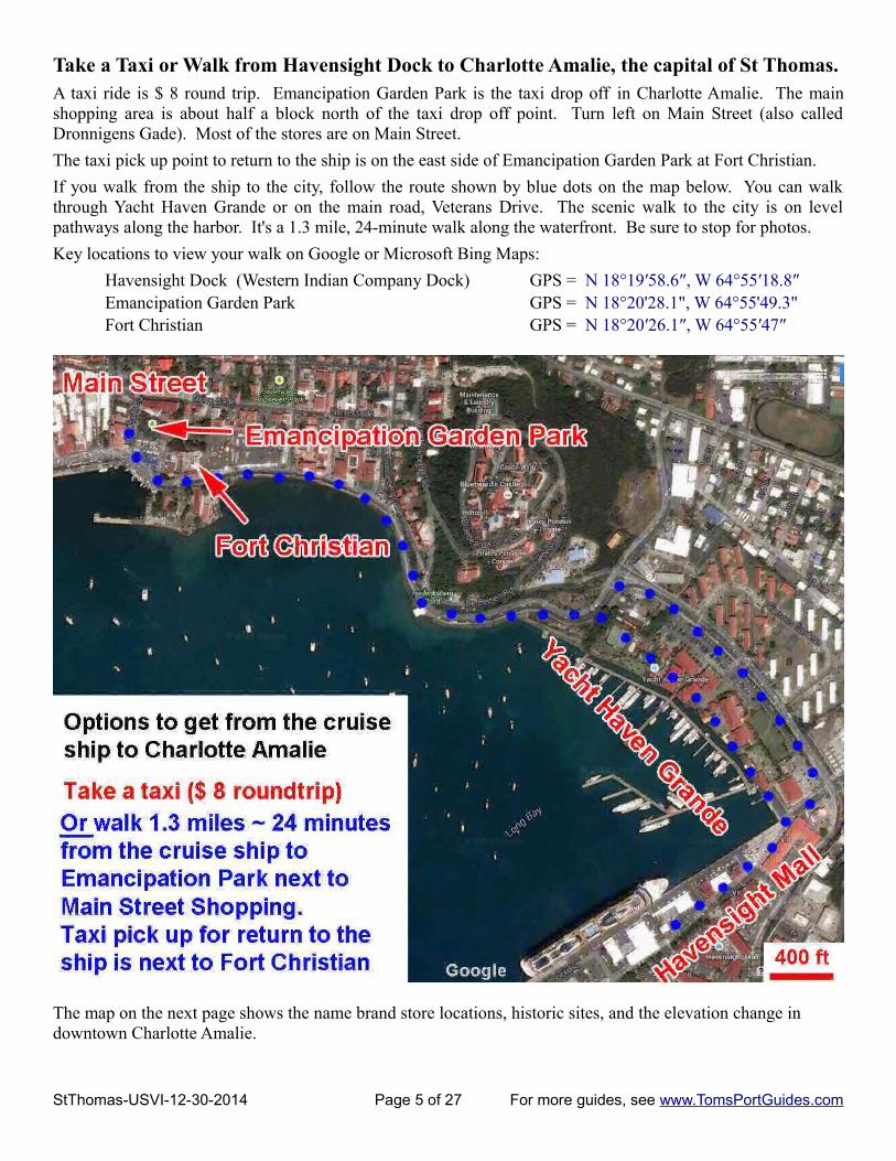
Take a Taxi or Walk from Havensight Dock to Charlotte Amalie, the capital of St Thomas. A taxi ride is $ 8 round trip. Emancipation Garden Park is the taxi drop off in Charlotte Amalie. The mainshopping area is about half a block north of the taxi drop off point. Turn left on Main Street (also calledDronnigens Gade). Most of the stores are on Main Street.
The taxi pick up point to return to the ship is on the east side of Emancipation Garden Park at Fort Christian.
If you walk from the ship to the city, follow the route shown by blue dots on the map below. You can walkthrough Yacht Haven Grande or on the main road, Veterans Drive. The scenic walk to the city is on levelpathways along the harbor. It's a 1.3 mile, 24-minute walk along the waterfront. Be sure to stop for photos.
Key locations to view your walk on Google or Microsoft Bing Maps:
Havensight Dock (Western Indian Company Dock) GPS = N 18°19′58.6″, W 64°55′18.8″Emancipation Garden Park GPS = N 18°20'28.1", W 64°55'49.3"Fort Christian GPS = N 18°20′26.1″, W 64°55′47″
The map on the next page shows the name brand store locations, historic sites, and the elevation change in downtown Charlotte Amalie.
StThomas-USVI-12-30-2014 Page 5 of 27 For more guides, see www.TomsPortGuides.com

Elevation above sea level, Shopping, and Historic Sites in Downtown Charlotte Amalie (map below)
StThomas-USVI-12-30-2014 Page 6 of 27 For more guides, see www.TomsPortGuides.com

Elevation above sea level is important for people who do not want to walk up/down stairs. I have shownelevation in purple color on the map on the previous page. Along the harbor, the elevation is ~ 25 feet. Fromthe harbor to the main shopping area, there is a very slight, 9 foot increase in elevation. That is almostimperceptible. Hence, walking from the harbor north to shopping areas is essentially on flat, level pathways.
However, there are two hills in this part of center city. The right side of the map shows that if you walk northfrom Fort Christian to Blackbeard's Castle, you are walking uphill from an elevation of 25 feet at the harbor to165 feet above sea level at Blackbeard's Castle on the top of the hill. That's like climbing a 14-story building.
There is another hill on the west side of the shopping area that rises to 240 feet above sea level, but you will notbe walking up that hill.
Shopping - Your cruise ship will provide maps and guidance on where they want you to shop. As you can seeon the map on the previous page, brand name stores are primarily on Main Street, (also called DronnigensGade) west of Emancipation Gardens Park. There are also many small shops in the center city area.
The best buys are jewelry, alcohol, china, crystal, perfume, art, clothing, watches and cameras. As you know,it's easier to spot the best bargains if you know “typical” prices for items.
List of Brand Name Stores shown on the map
Vendor's Plaza GPS = N 18°20′26.3″, W 64°55′49.6″
Vendor's Plaza is on the waterfront between Emancipation Garden Park and Fort Christian. It's has tents andbooths with silver jewelry, t-shirts, tropical print wrap skirts, shirts and dresses, imitation bags, watches,souvenirs, trinkets, and more. There is also hair braiding, a photo-op with a donkey, a coconut-for-sale stand,local food vendors and an ice-cream stand. The stands are open 7:30 am to 5 pm Monday through Saturday.
There's a Co-op store that sells locally made crafts across the street from Vendors Plaza.
Historic Sites in Charlotte Amalie
Map Historic Site GPS
1 Virgins Islands Legislature N 18°20′23.9″, W 64°55′46.3″
2 Fort Christian Built by the Danish in 1676. Open Monday-Friday, 8:30am to 4:30pm. The museum has exhibits on the history of the Virgin Islands from the Stone Age to the present, as well as a natural history section, a furniture collection from the Danish period and an art gallery. See http://www.nps.gov/nr/travel/prvi/pr29.htm
N 18°20′26.1″, W 64°55′47″
3 Emancipation Park Commemorates July 3rd, 1848 emancipation of slaves in the Danish West Indies. Contains a conch blower statue as a symbol of emancipation, a reproduction of the Liberty Bell (every U.S. state and territory has a copy of the Bell) and a bust of Denmark’s King Christian IX.
N 18°20′28.7″, W 64°55′50.1″
StThomas-USVI-12-30-2014 Page 7 of 27 For more guides, see www.TomsPortGuides.com
A Ammolite GalleryB Beverly's/CaribanaC BillabongD Bobby's JewelersE Breitling BoutiqueF Cardow JewelersG Diamonds InternationalH Diamonds International Watch
I Eden JewelersJ Effy JewelryK Fresh ProduceL Get CharmedM House of Rajah JewelersN HublotO Imperial JewelersP Jewels St ThomasQ Kay's Fine Jewerly
R Little SwitzerlandS Local Color T Pena Duty Free St Thomas U Tanzanite International V The Pearl Lady W Tiffany & Company Boutique X Trident Jewels & TimeY Vendor's Plaza

4 Grand Galleria Opened in 1840 as a Hotel and Coffee House. It currently houses shops and restaurants
N 18°20′29.8″, W 64°55′48.8″
5 Frederick Luthern Church The oldest church building on St. Thomas and the second oldest Lutheran Church in the Western Hemisphere. Dates back to 1666 and is in use today. The church has a yellow-gold color and a large 'welcoming arms' staircase.
N 18°20′31.4″, W 64°55′47.3″
6 Historical Trust Museum Entrance is through a gated alley; use the buzzer by the gate to ring the museum for entry. The Museum has antique furnishings, artifacts and old photos. Open M-F 10-3pm.
N 18°20'30.6", W 64°55'42.8"
7 Seven Arches Museum The arches support a staircase N 18°20'34.0", W 64°55'43.0"
8 Government House Built in 1867, this neoclassical, building with intricate ironwork exemplifies the grandeur of official buildings during Danish colonialtime. You can visit the lobby which contains: display boards of the islands’ governors including Danish, Naval and Civilian; and paintings. Visitors must check in with the security officer at the entrance. Open 8am-5pm weekdays,
N 18°20′33″, W 64°55′44.8″
9 99 Steps There are many stairs on the hill leading to Blackbeard's Castle. These steps were built in the 1700's using bricks from ship's ballast. The steps are a postcard photo opportunity.
N 18°20′32.7″, W 64°55′48.4″
10 Haagensen House One of the most beautiful interiors of manor homes. At the top of 99 Steps
11 Blackbeard's Castle “Blackbeard’s Castle” is a misnomer. It's actually a watch tower to guard the city dating back to 1680. There is an admission fee of $ 10 to tour the site which consists of several 1830-era historic buildings furnished with beautiful antiques.
N 18°20′37.7″, W 64°55′47.2″
12 Crown House Occupied by Danish Royalty during their visits. Near Blackbeard's Castle
13 Hotel 1829 Great views from the terrace N 18°20′33″, W 64°55′49.7″
14 Post Office N 18°20′29.5″, W 64°55′51.2″
15 Reformed Church For 350 years, the congregation has been worshiping at this site. The current church was built in 1848.
N 18°20′33.5″, W 64°55′54.6″
16 Synagogue It's the second-oldest synagogue in the Western Hemisphere and the oldest continuously used Synagogue under the American Flag. The congregation was founded in 1796 by Sephardic Jews. Officially named Beracha Veshalom Vegimulth Hasidim, meaning Blessing and Peace and Loving Deeds, the synagogue was constructed in 1833
N 18°20′33.5″, W 64°55′57.6″
17 Market Square The site was used to auction African slaves. Today it's an open-air market for fruits and vegetables.
N 18°20′29.1″, W 64°56′05.3″
Use the GPS coordinates from the table above in Bing, Google, or Google Earth.exe maps to view the area.When viewing a map on Google Earth.exe, the elevation above sea level is shown on the lower right handsection of the screen. Elevation corresponds to the location of the cursor on the map. Move the cursor over themap and watch the elevation change to preview how far you will have to climb up the hill.
Slightly Different Maps for the Walking Tour
I used the Tourist Bureau “official” historic site walking tour of Charlotte Amalie on the previous pages. Thereare several variations of this walking tour. On the next page, I've shown an old walking tour map.
This map is useful because it shows several of the stairs to get to the top of the hill. I have highlighted thelocation of the stairs in purple color on the map. Note the historic site numbering is slightly different on thismap from the map I used on the previous pages.
StThomas-USVI-12-30-2014 Page 8 of 27 For more guides, see www.TomsPortGuides.com

Historic Walking Tour map from http://usvivideo.blogspot.com/ I highly recommend watching this video of the walking tour of Charlotte Amalie from the link below
https://www.youtube.com/watch?feature=player_embedded&v=ciE8DHGZfFU
Climbing up/down “99 steps” and other stairs can be a problem for the mobility impaired
It's easy to walk in the downtown shopping area ofCharlotte Amalie because there is little change inelevation. You don't have to climb stairs.
However, there are many stairs in the area near 99 steps(photo at left), going up the hill to Haagensen Houseand Blackbeard's Castle.
You can avoid walking up the stairs if you take a tourfrom the cruise ship dock because the tour bus/taxi willdrop you off at the top of the hill. However, you stillhave to walk down the stairs from the top of the hill tothe center city to get the bus/taxi back to the ship.
People with mobility problems may find it difficult towalk up/down all of these stairs. My wife would notwalk the stairs because of her arthritic knees.
If mobility is not an issue for you, this is a must visitarea. There are several beautiful, historic mansions andbuildings with fine architectural detail and antiquefurnishings. Also, you'll have great views of the harborfrom the top of the hill.
StThomas-USVI-12-30-2014 Page 9 of 27 For more guides, see www.TomsPortGuides.com

Crown Bay Dock GPS = N 18°19′53.4″, W 64°57′12.4″Crown Bay Center is next to cruise ship dock see http://www.crownbaycenter.com/
StThomas-USVI-12-30-2014 Page 10 of 27 For more guides, see www.TomsPortGuides.com

Crown Bay has dock space for two cruise ships.
Key locations to view your walk on Google or Microsoft Bing Maps:Crown Bay Dock GPS = N 18°19′53.4″, W 64°57′12.4″Emancipation Garden Park GPS = N 18°20'28.1", W 64°55'49.3"Fort Christian GPS = N 18°20′26.1″, W 64°55′47″
Directory of Shops and Services at Crown Bay Center-see the map on the previous page
St Thomas Cyril E. King Airport (Airport Code = STT) GPS coordinates = N 18°20'06.5", W 64°58'18.3"
Taxi fare from Airport to Charlotte Amalie = $ 7 single or $ 6 per person for two or more people
StThomas-USVI-12-30-2014 Page 11 of 27 For more guides, see www.TomsPortGuides.com
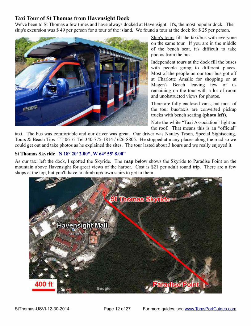
Taxi Tour of St Thomas from Havensight DockWe've been to St Thomas a few times and have always docked at Havensight. It's, the most popular dock. The ship's excursion was $ 49 per person for a tour of the island. We found a tour at the dock for $ 25 per person.
Ship's tours fill the taxi/bus with everyoneon the same tour. If you are in the middleof the bench seat, it's difficult to takephotos from the bus.
Independent tours at the dock fill the buseswith people going to different places.Most of the people on our tour bus got offat Charlotte Amalie for shopping or atMagen's Beach leaving few of usremaining on the tour with a lot of roomand unobstructed views for photos.
There are fully enclosed vans, but most ofthe tour bus/taxis are converted pickuptrucks with bench seating (photo left).
Note the white “Taxi Association” light onthe roof. That means this is an “official”
taxi. The bus was comfortable and our driver was great. Our driver was Nauley Tyson, Special Sightseeing,Tours & Beach Tips TT 0616 Tel 340-775-1814 / 626-8805. He stopped at many places along the road so wecould get out and take photos as he explained the sites. The tour lasted about 3 hours and we really enjoyed it.
St Thomas Skyride N 18° 20' 2.00", W 64° 55' 8.00"
As our taxi left the dock, I spotted the Skyride. The map below shows the Skyride to Paradise Point on themountain above Havensight for great views of the harbor. Cost is $21 per adult round trip. There are a fewshops at the top, but you'll have to climb up/down stairs to get to them.
StThomas-USVI-12-30-2014 Page 12 of 27 For more guides, see www.TomsPortGuides.com

First Stop = Drop Off Passengers in Charlotte Amalie N 18°20'28.0", W 64°55'50.2"
The taxi stopped in front ofLittle Switzerland, acrossfrom Emancipation GardenPark.
This store is highlyrecognizable as a referencepoint for your shoppingtour. When looking at thestore, turn right and walk ~200 feet to Main Street(Dronnigens Gade) and turnleft to explore the shoppingarea.
Roundtrip cost for taxi/bus service between Havensightand Charlotte Amalie = $ 8.
Second Stop = Drop Off Passengers at Magen's Bay Beach N 18°21'40.7", W 64°55'24.8"
Round trip taxi/bus cost from Havensight to Magen's Beach is ~ $ 10.
The non-resident fee to use the beach is $ 4 per adult. Most of the people got off our bus to stay at the beach.
Magen's Bay Beach is the most popular beach on St. Thomas. The water is usually very calm in this heart-shaped protected bay. Beach chairs and floats are available for rent and burgers, pizzas and other snacks can befound at the snack bar. Lifeguards are on duty every day.
This beautiful one-mile public park was donated to the people of the Virgin Islands by Arthur Fairchild.
StThomas-USVI-12-30-2014 Page 13 of 27 For more guides, see www.TomsPortGuides.com
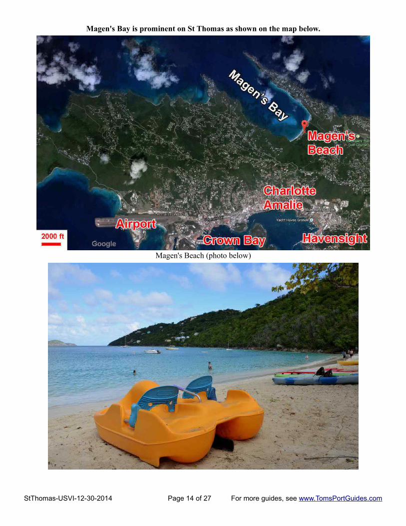
Magen's Bay is prominent on St Thomas as shown on the map below.
Magen's Beach (photo below)
StThomas-USVI-12-30-2014 Page 14 of 27 For more guides, see www.TomsPortGuides.com

Mahogany Run Golf Course N 18° 21' 23.00", W 64° 54' 33.00"
We stopped at the side of the road to photograph Mahogany Run Golf Course, the only course on the island. It'scalled the Devil's Triangle. See http://www.mahoganyrungolf.com/
Next stop at the road side = Hidden Valley N 18° 20' 58.00", W 64° 53' 19.00"
Most of the buildings on the hillside are government housing.
StThomas-USVI-12-30-2014 Page 15 of 27 For more guides, see www.TomsPortGuides.com
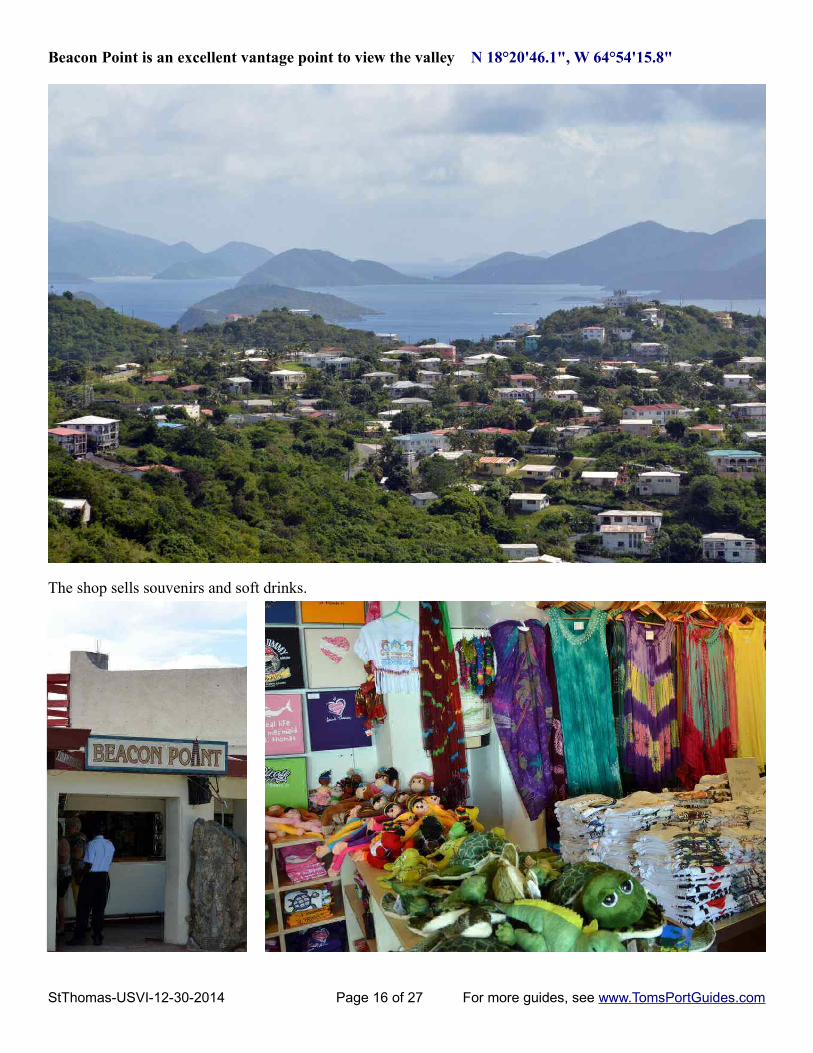
Beacon Point is an excellent vantage point to view the valley N 18°20'46.1", W 64°54'15.8"
The shop sells souvenirs and soft drinks.
StThomas-USVI-12-30-2014 Page 16 of 27 For more guides, see www.TomsPortGuides.com

Roadside stop for views of Crown Bay Dock N 18° 21' 2.00", W 64° 55' 29.00"
You could also see Havensight from this vantage point, but my view was obstructed by trees beside the road.
Next stop = Mountain Top (Signal Hill) on Crown Mountain N 18° 21' 20.00", W 64° 56' 45.00"This is the highest point on St Tomas measuring 455 meters (1493 feet) high.
I've been to Mountain Top three times and never had a clear view of the islands, so I took a photo of the signthat shows what you are supposed to see. However, Mountain Top it a great place to relax, have a drink and dosome shopping.
StThomas-USVI-12-30-2014 Page 17 of 27 For more guides, see www.TomsPortGuides.com

It's a large, colorful place to have a drink, a snack, buy some rum,relax, and enjoy shopping for a wide variety of souvenirs, shirts, hats,beach wear, handbags, sun glasses, jewelry, gifts, etc.
Our taxi left Mountain Top, stopped to drop some people in CharlotteAmalie, and returned to the ship. A good time was had by all!
StThomas-USVI-12-30-2014 Page 18 of 27 For more guides, see www.TomsPortGuides.com
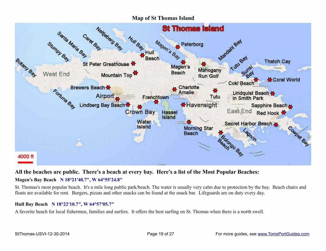
Map of St Thomas Island
All the beaches are public. There's a beach at every bay. Here's a list of the Most Popular Beaches:Magen's Bay Beach N 18°21'40.7", W 64°55'24.8"
St. Thomas's most popular beach. It's a mile long public park/beach. The water is usually very calm due to protection by the bay. Beach chairs and floats are available for rent. Burgers, pizzas and other snacks can be found at the snack bar. Lifeguards are on duty every day.
Hull Bay Beach N 18°22′10.7″, W 64°57′05.7″
A favorite beach for local fishermen, families and surfers. It offers the best surfing on St. Thomas when there is a north swell.
StThomas-USVI-12-30-2014 Page 19 of 27 For more guides, see www.TomsPortGuides.com

Brewers Bay Beach N 18°20′35.5″, W 64°58′37″It's a family favorite for weekend picnics and gatherings. Visitors can relax in the shallow waters or sunbatheon the wide shore.
Lindbergh Bay N 18°20'07.0", W 64°57'51.8"Named after the famous aviator who landed nearby in 1928, this tranquil bay is flanked by three hotels, palmtrees and sea grapes that line the shore.
Morning Star Beach N 18°19′12.1″, W 64°55′10.4″Located at the Frenchman’s Reef & Morning Star Marriott Resort, this beach offers a restaurant and bar, watersports rentals and a scenic view of the cruise ships sailing through the harbor.
Bolongo Bay N 18°18′46.6″, W 64°53′47.7″Located on the south shore of the island at the Bolongo Beach Resort, this beach offers a variety of water sportsand beach toy rentals.
Secret Harbor Beach Resort N 18°19'04.4", W 64°51'06.9"A calm, quiet beach located at Secret Harbor Beach Resort, this beach has a floating swim platform and beachchairs available for rent.
Sapphire Beach N 18°20′06.7″, W 64°51′02.5″The sapphire-blue waters here are great for snorkeling, windsurfing, jet skiing and more. The beach is locatedon the east end at Sapphire Beach Resort.
Lindquist Beach in Smith Bay Park N 18°20'18.4", W 64°51'23.8"It's one of St. Thomas's most beautiful and pristine beaches. The water is crystal-clear and typically calm. Theleft side of the beach is great for snorkeling.
“Pristine” is “code word” for undeveloped area with few amenities/services. You access the beach via a dirtroad, and pay $ 2 admission fee to enter Smith Bay Park. There's a lifeguard, a few picnic tables, and porta-potties. If you want to get away from commercial activities and enjoy pristine nature at its best, this is thebeach for you.
Coki Beach N 18°20′57.4″, W 64°51′59.7″Located on Coki Point, this white sand beach with crystal clear water offers excellent snorkeling and diving.Beachside eateries serve picnic table fare including burgers, sandwiches and some local dishes. There's a diveshop, jet ski rental and several vendors renting snorkel gear, beach chairs and floats. Right next to Coral WorldOcean Park, it’s easy to make a day of visiting both attractions.
Other Points of Interest on St ThomasSt Peter Great House and Botanical Gardens N 18°21'26.9", W 64°56'43.2"see http://www.greathousevi.com/index.html
In the 1800's this was part of the 150-acre St. Peter Plantation. Today, it's an estate with 20,000 sq. ft. availablefor weddings and events. The air-conditioned banquet hall can seat 500. The Blue Orchid Restaurant is openfor Cocktails and Dinner Monday through Saturday. Reservations are recommended.
The site is open to visitors 9 am to 5 pm Monday-Saturday. The admission fee of $ 8 offers an observation deckwith views of 15 other Virgin Islands, a botanical garden, nature trail, tropical bird aviaries, fish ponds, etc.
The Botanical Garden has an international collection of 250 species of tropical plants, palms and orchidsrepresenting more 50 families and 200 genera. Plants are labeled for identification, naming each by species,family, and country of origin. The beautiful tropical gardens are located amongst waterfalls, meanderingstreams, and overlook the Caribbean Sea. A stroll through the Botanical Garden is a photographer's paradise.Colorful Macaws and Koi fish complete your tropical experience.
StThomas-USVI-12-30-2014 Page 20 of 27 For more guides, see www.TomsPortGuides.com

Map showing location of the Great House site
Coral World Ocean Park N 18°20'57.6", W 64°51'48.6" see http://coralworldvi.com/
Adult General Admission = $ 19 Combination with Butterfly Garden at Havensight Mall next to cruise ships = $ 27
The general admission price gives you access to all the exhibits in the park. There are additional prices for special activities such as diving while wearing a helmet, swimming with sea lions, etc.
You could spend many hours viewing and photographing beautiful marine life and learning about them from the park guides. It's a must visit site.
Marine Gardens features many tanks showcasing hundreds of marine species in their native surroundings.
Turtle Pool - observe huge turtles and see them feeding.
Stingray Lagoon – watch their graceful movement through the water and their habits such as burying themselves in the sand for camouflage.
Touch Pool – under supervision of a park guide, you can reach into the water to gently touch several sea creatures.
Shark Shallows – see sharks from above and below through an underwater window.
Undersea Observatory Tower – View sea life unrestricted, at a natural coral reef from 15 feet underwater.
StThomas-USVI-12-30-2014 Page 21 of 27 For more guides, see www.TomsPortGuides.com

Why Visit St John Island?Today, St John is a “laid-back bit of Caribbean Paradise. Two-thirds of the island were donated to the UnitedStates by Lawrence Rockefeller for use as a National Park. This created an unspoiled get-away offeringtranquil beaches, sleepy lagoons, underwater coral gardens, scenic roads, well-maintained walking trails, lushfoliage, and fascinating plantation ruins.”
The quote above is from http://www.virginislandsthisweek.com/ I highly recommend this website.Download the pdf file for the week before your cruise. It's loaded with specific, useful information.
The map below shows the ferry boat route from Red Hook to Cruz Bay. Note there are two ferry boat docks onSt John, namely, a dock for pedestrians and a dock for cars.
Red Hook Bay Ferry Terminal N 18°19'36.1", W 64°50'57.0"This terminal serves both pedestrians and cars.
St John Cruz Bay Ferry Dock for PEDESTRIANS N 18°19'52.4", W 64°47'43.2"Ferry Dock for CARS N 18°19'39.8", W 64°47'36.3"
Ferry Boat Service Connects the Virgin Islands and Puerto RicoFor details on the ferry service, see http://www.vinow.com/general_usvi/interisland_ferry/
Transportation Services and Varlack Ventures (340) 776-6282 (340) 776-6412
It's a 20 minute boat ride between Red Hook and Cruz BayOne Way Round Trip
Adult (Non-Resident) $7.00 $14.00Luggage/Boxes $4.00 piece
Red Hook → Cruz Bay
5:30 am | 6:30 | 7:30 | 8:00 | 9:00 | 10:00 | 11:00 | Noon | 1:00 | 2:00 | 3:00 | 4:00 | 5:00 | 6:00 | 7:00 | 8:00 | 9:00 | 10:00 | 11:00 | MidnightCruz Bay → Red Hook
6:00 am | 7:00 | 8:00 | 9:00 | 10:00 | 11:00 | Noon | 1:00 | 2:00 | 3:00 | 4:00 | 5:00 | 6:00 | 7:00 | 8:00 | 9:00 | 10:00 11:00pm
Cruz Bay is called “Love City”. It's a delightful little town where the natural beauty of the area has attractedand inspired creative artists to produce art in several mediums. Shopping includes brand name merchandise, butthere is much more! You'll find boutiques, galleries, and colorful shops with unique, hand-crafted treasures ofjewelry, local art, spices, beachwear, gifts, souvenirs, and many eateries and bars to relax and enjoy the views.
StThomas-USVI-12-30-2014 Page 22 of 27 For more guides, see www.TomsPortGuides.com

Map of Cruz Bay
The PEDESTRIAN Ferry Dock is near the center of the small town of Cruz Bay. You will find many shops andrestaurants in the downtown area. I have shown the restaurants as blue dots on the map above.
Mongoose Junction - the premier shopping center in Cruz Bay N 18°19′57″, W 64°47′32.4″ see http://www.Mongoosejunctionstjohn.com/
It's a beautiful stone and mahogany shaded shopping area showcasing architecture that is unique to the Caribbean. You will find fabulous shopping, galleries and great food. Shop for designer or locally made jewelry, gifts, resort wear, swimwear and casual clothing at Bamboula, Big Planet, Bougainvillea, Fabric Mill, Hurricane Alley, and Made in St. John.
Find beautiful jewelry and art at Bajo el sol Gallery, Best of Both Worlds, Caravan Gallery, Friends of the National Park, Island Fancy, Portico, R&I Patton Goldsmiths, Royal Caribbean Jewelers, and Sea Leathers.
Lumberyard Complex has three important businesses for tourists N 18°19′53.4″, W 64°47′36.4″ • Cruz Bay Watersports (340) 776-6234
Daily, local area SCUBA wreck & reef dive trips. PADI & NAUI 5-star training. Snorkel trips. Dive & snorkel trips to British Virgin Island locations --the Baths, Caves, Foxy’s, Soggy Dollar Bar, Jost van Dyke. Parasailing & Waverunner excursions. Dinghy rental, half or full day. Gear & equipment rental.
• Beach Scooters (340) 693-7368 Scooter rentals.• Frames of Mind Gallery & Custom Framing (340) 693-8560
Original work of many local artists as well as tropical prints, posters & greeting cards. Large inventory of frames & mats for custom framing. Worldwide shipping.
StThomas-USVI-12-30-2014 Page 23 of 27 For more guides, see www.TomsPortGuides.com

The Marketplace is a local shopping mall catering to residents N 18°19′39.4″, W 64°47′27.1″see http://www.stjohnmarketplace.com/
The Marketplace is a sanctuary of retail shops, galleries, and food and dining options. The Marketplace is hometo Starfish Market, St. John’s largest grocery supermarket, St. John Hardware, Chelsea Drug Store and more!
Elaine Lone Sprauve Museum & Library N 18°19′47.1″, W 64°47′30.7″
Housing a collection of historic photographs, rare documents and other artifacts, this museum is located in a restored plantation estate home
US National Park Visitor Center N 18°19′57.7″, W 64°47′38″THIS IS A MUST VISIT. IT SHOULD BE YOUR FIRST STOP IN CRUZ BAY
The park office is about 2 blocks north of the ferry dock on highway 20. I estimate the walk will take ~ 5 minutes. The National Park Visitor Center is open 8 am to 4:30 pm.
The US National Park on St John covers two-thirds of the island plus thousands of acres of submerged land,coral reefs and mangrove habitats. All the beautiful places you want to see and visit are on park land. The parkrangers know the island and can provide detailed advice and descriptions on what there is to see and do.Activities include bird watching, nature walks and hikes, the petroglyphs, tours, demonstrations, water sportsand an evening program.
Park Admission Fees There is no charge for entrance into Virgin Islands National Park. However, a same-day user fee is collected at Trunk Bay. Children age 16 and under are admitted free; adults, $4; individual annual pass, $10; family annual pass, $15; Golden Age and Golden Access annual cardholders are admitted at half price.
National Park Service Guided Reef Bay Trail Hike
Rated #1 of the “5 Best Things to Do on St John”
For $ 30/person, the Park Service provides a guided Reef Bay trail hike. Transportation is provided from the National Park Visitor Center in Cruz Bay to the trail head. The hike includes the spur trail to the petroglyphs and a visit to Reef Bay sugar mill.Hikers are met at Reef Bay Beach and taken back to the Park Visitors Center in Cruz Bay by boat. Reservations must be made in advance by calling (340) 779-8700.
See the map at left.Reef Bay Trail Head is near Marney Peak which has an elevation of 1147 feet. I'm not sure what the height is at the trail head, but it's obvious you are walking downhill between the mountains. The hike ends at the beach near the ruins of the sugar mill.
The US Park Service publishes extensive FREE information
Download visitor guides from US Park Service http://www.visitusvi.com/download_brochures
The map on the next page is from http://www.nps.gov/hfc/carto/PDF/VIIShbmap3.pdf
It's a high resolution map. Enlarge it to see more detail
StThomas-USVI-12-30-2014 Page 24 of 27 For more guides, see www.TomsPortGuides.com

Download this map from the US National Park service at http://www.nps.gov/hfc/carto/PDF/VIIShbmap3.pdf
StThomas-USVI-12-30-2014 Page 25 of 27 For more guides, see www.TomsPortGuides.com

Trunk Bay Underwater Snorkeling Trail N 18°21′14.3″, W 64°46′06.7″
This 225-yard snorkeling trail has underwater plaques that describe the species of coral. It's very popular andthe beach is regarded one of the most beautiful in the world. Facilities include a bathhouse, snack bar, souvenirshop and snorkel gear rentals. Lifeguards are on duty.
Waterlemon Cay is a great and popular area for snorkeling in Leinster Bay. Starting at Annaberg Plantation Ruins parking lot, it's 8/10th of a mile walk along a flat trail on the bay's edge Annaberg Plantation Ruins parking lot N 18°21′46.4″, W 64°43′49.7″
Sightseeing for the mobility impaired and people who don't want to walk much or hike
There is a taxi stand at the ferry boat dock. A two-hour tour of St John is $ 25 each person for two or more people plus tip. That would be a low stress, easy way to see the sights and no pre-planning is required.
Taxi Rates from Cruz Bay (2014 prices)
Official taxis or vans have the letters JP on their license plates.
1 PASSENGER 2 OR MORE PEOPLE
Annaberg............................. 18.00...........................................................9.00 Caneel Bay............................ 6.00...........................................................3.00 Chocolate Hole..................... 7.00...........................................................6.00 Cinnamon Bay....................... 9.00...........................................................7.00 Coral Bay............................. 16.00...........................................................9.00 Gallows Point........................ 5.00...........................................................4.00 Hurricane Hole1.................... 9.00.........................................................13.00 Maho Bay............................ 18.00...........................................................9.00 Reef Bay Trail........................ 9.00 ..........................................................7.00 Salt Pond............................. 20.00.........................................................14.00 Trunk Bay............................... 8.00...........................................................6.00 Westin Resort, St. John........ 6.00...........................................................5.00 Zootenval............................. 18.00.........................................................12.00
NOTE: Mosquito Borne DiseaseThere are two mosquito transmitted diseases (virus), Dengue, and Chikungunya Fever confirmed in the Virgin Islands. Take proper precautions which usually involve insect deterrent spray on clothing and exposed skin.
StThomas-USVI-12-30-2014 Page 26 of 27 For more guides, see www.TomsPortGuides.com

User Feedback Is Welcome GoalMy guides are designed to help you plan a great cruise vacation by providing information such as where the ship docks, location of tourist sites, public transit, walking tour maps, things to see and do, travel issues unique to the port, etc. Knowledge of ports is important when planning shore excursions because you have to make many decisions and commitments long before your ship docks. I believe the information in this guide is accurate, however you are responsible to verify accuracy of the information that you use to plan your vacation.
Information on cruise ports frequently changes such as bus routes, admission fees to sites, rental car locations, etc. Cruise Critic is the best source for up-to-date, detailed information on travel details for shore excursions, reviews of cruise ships, etc. There are many knowledgeable people on Cruise Critic who are willing to share their expertise and travel experience. I highly recommend www.CruiseCritic.com; it's free to join.
Why feedback is importantUser feedback helps me make corrections and improve the format and content in my quest to produce the“ultimate” port guides. I welcome offers to collaborate with me or provide materials for use in my guides.
PLEASE Help “spread the word” about my websiteThe only negative feedback I get is, “I wish I knew about your port guides before my vacation”. Please tellyour friends and post a reference to my guides and website on the blogs. To receive email notification whennew guides are available, send your email address to me at [email protected]
Copyright Notice & Terms and Conditions for Use of My Guides
My port guides and everything on my website www.TomsPortGuides.com is copyrighted by Thomas Sheridanwith all rights reserved, and protected by international copyright laws.
PERMITTED USE: Personal, non-commercial use of my port guides and/or material from my website.
I allow individuals to take my guides apart for personal, non-commercial use. Many cruisers carry a map or afew pages from my guide on a shore excursion. That's OK. I also allow people to post my guides on websitesthey set up for fellow travelers to share information on shore excursions such as the websites set up by CruiseCritic members for the Roll Calls. That's OK. My guides are for use and enjoyment of individual travelers.
PROHIBITED USE of my port guides and/or material from my website.NO person, company, organization, website, etc. is permitted to use material from my website for a commercialpurpose, to sell, require a membership to download my port guides, or use my copyrighted material for acommercial purpose.
NO person, company, organization, website, etc. is permitted to distribute excerpts from my guides or materialfrom my website as electronic, digital, or paper copies. My Port Guides must be kept intact, as downloadedfrom my website, with this copyright notice.
NO Cruise Ship employee, representative, contractor, port lecturer, etc. is permitted to distribute excerpts frommy guides or material from my website as electronic, digital or paper copies. My Port Guides must be keptintact, as downloaded from my website, with this copyright notice. A blatant example of violation of mycopyright was a cruise ship docked in Copenhagen where the shore excursion desk personnel removed mapsfrom my guide, removed my name as the copyright owner, and copied/distributed my maps.
Fortunately, a friend of mine on that ship complained to the purser and the ship stopped violating my copyright.
If there is any question about use of my guides, contact me at [email protected]
Tom Sheridan
StThomas-USVI-12-30-2014 Page 27 of 27 For more guides, see www.TomsPortGuides.com


