Town of Cornwall – Bicycle and Pedestrian Planning and Feasibility Study October 17, 2005 (Revised April 18, 2005) Prepared For: Town of Cornwall & Addison County Regional Planning Commission Prepared By: Erik Sandblom, PC Engineering & Environmental Consulting P.O. Box 212 368 Avenue D, Suite 15 Williston, VT 05495 Phone: 802-383-0486 • Fax: 802-383-0490 email: [email protected]
Transcript
Town of Cornwall – Bicycle and Pedestrian Planning and Feasibility Study October 17, 2005 (Revised April 18, 2005)
Prepared For: Town of Cornwall & Addison County Regional Planning Commission
Prepared By: Erik Sandblom, PC Engineering & Environmental Consulting P.O. Box 212 368 Avenue D, Suite 15 Williston, VT 05495 Phone: 802-383-0486 • Fax: 802-383-0490 email: [email protected]
Town of Cornwall Northeast Corridor - Bicycle and Pedestrian Feasibility Study
Revision: 04-18-2006 Page i
Executive Summary Erik Sandblom, PC (ESPC) has completed this Bicycle and Pedestrian Feasibility Study to evaluate several alignments to better connect the Village of Cornwall to the Town of Middlebury. This study was conducted for the Town of Cornwall and the Addison County Regional Planning Commission (ACRPC), with the ACRPC managing the project. Project elements have included conducting a Kick-Off and Local Concerns Meeting, developing potential alternatives, evaluating natural resource, cultural resource, utility, and right-of-way impacts, presenting alternatives, and preparing a final report with recommendations. The project area included the northeast corner of the Town of Cornwall, from the intersection of Route 74 and Route 30. The project was broken up into two general areas, being the areas in the vicinity of Route 30 and the areas in the vicinity of Route 125. In all, four alignments were evaluated along and connecting to Route 30 and three alignments were evaluated along and connecting to Route 125. Based on public feedback, it was determined that users of the facility shall be primarily pedestrians and bicyclists, and the facility should be cleared of snow for winter use. A preference was expressed for a separated facility from the roadway and, where possible, to divert from the roadway into scenic areas of this corridor. However, where separated facilities are not possible due to physical features of the landscape, environmental permitting, or right-of-way constraints, on-road facilities are still desired. It is also clear that a connection to low traveled roads such as Cider Mill Road, Ridge Road, James Road, and Morse Road is an important connection for the project.
Recommended Alignments Alternatives Along or Connecting to Route 30 Based on the four alignments evaluated the preferred alignment for this portion of the study area is Alternative B – a shared use pathway along the south and east sides of Route 30. It should be noted, however, that the true viability of Option B will depend on the outcome of further right-of-way (ROW) research that is necessary to resolve conflicting historical ROW data. If the pathway cannot be constructed within the ROW, tehn this option may not be viable due to the opposition expected by adjacent landowners and likely associated difficulty to acquire permanent ROW or construction easements. Therefore, it is recommended to pursue Option B, pending the outcome of ROW research. If it determined that insufficient ROW is available, or if a significant process, with an uncertain outcome, will be required to obtain the wider ROW, then it is recommended to revert to Alternative A, shared use shoulders along Route 30, to proceed with in design and construction. Alternative A will still meet the Purpose and Need of the project, with minimal impacts, although it has the added drawbacks of not physically separating users from traffic and can undermine traffic calming efforts.
Town of Cornwall Northeast Corridor - Bicycle and Pedestrian Feasibility Study
Revision: 04-18-2006 Page ii
From a funding perspective, this approach is feasible since both Alternatives A and B are relatively similar in cost, and switching from one alternative to the other at the beginning of the design, following the survey, will not have a significant impact on the budget or schedule of the project. Therefore, the total estimated cost for Alternative B or A would be $2.8 million to $2.9 million. Alternatives Along or Connecting to Route 125 The recommended alignment for this section of the study area is Alternative G – a shared use pathway from James Road to the Middlebury College pathways. This alignment best meets the desires of Cornwall residents, and provides a scenic route to be enjoyed by outdoor enthusiasts. The alignment is located on Middlebury College property and the Route 125 ROW. Resource impacts are expected to be minimal, or the pathway alignment can be modified to avoid impacts, although additional investigation of wetlands and archeological resources will be required. The total cost for this alternative to go from James Road to the Middlebury town line is approximately $1.5 million.
Town of Cornwall Northeast Corridor - Bicycle and Pedestrian Feasibility Study
Revision: 04-18-2006 Page iii
Table of Contents Executive Summary.............................................................................................i I. Introduction ..................................................................................................1 II. Purpose and Need........................................................................................1 III. Project Area and Existing Conditions ........................................................2
Project Area......................................................................................................2 Origins and Destinations...................................................................................2 Users ................................................................................................................2 Past Studies .....................................................................................................2 Roadways.........................................................................................................3 Utilities ..............................................................................................................3 Existing Bicycle / Pedestrian Facility Locations ................................................4
IV. Natural and Cultural Resources..................................................................4 Surface Waters and Wetlands ..........................................................................4 Stormwater .......................................................................................................5 Rare, Threatened and Endangered Species/Flora/Fauna/Forest Land ............5 Hazardous Wastes ...........................................................................................5 Historic / Archeological .....................................................................................5 Agricultural Lands.............................................................................................6
V. Right of Way .................................................................................................6 VI. Public Involvement.......................................................................................7 VII. Conceptual Alignments ...............................................................................7
Alternative A: Route 30 Shared Use Shoulders Both Sides..............................8 Alternative B: Shared Use Path Parallel to Route 30........................................9 Alternative C: Shared Use Path – Morse Road to Route 30 ...........................11 Alternative D: Shared Use Path – Robbins Road to Andrus Pitch ..................13 Alternative E: Route 125 Shared Use Shoulders Both Sides..........................14 Alternative F: Shared Use Path Parallel to Route 125....................................15 Alternative G: Shared Use Path – Route 30 to James Road ..........................16
VIII. Preliminary Project Cost Estimate ............................................................17 IX. Compatibility with Planning Efforts ..........................................................19 X. Project Time Line........................................................................................19 XI. Recommended Alternatives ......................................................................19 Appendix A – Local Concerns Meetings #1 and #2 Minutes Public Correspondence Appendix B – Conceptual Alignment Descriptions Appendix C – Cost Breakdown Appendix D – Project Development Outline Appendix E – Archaeological Assessment Appendix F – Natural Resources Assessment Hazardous Waste Site Locator Map Appendix G – VTrans Right-Of-Way (ROW) Documents Appendix H – Non-motorized Routes (Maps Provided by Lake Champlain
Bikeways and the Middlebury College Cornwall Path Committee) Appendix I – Route 30 and Route 125 Accident Data
Town of Cornwall Northeast Corridor - Bicycle and Pedestrian Feasibility Study
Revision: 04-18-2006 Page iv
Town of Cornwall Northeast Corridor - Bicycle and Pedestrian Feasibility Study
Revision: 04-18-2006 Page 1
I. Introduction This Bicycle and Pedestrian Planning and Feasibility Study has been completed by Erik Sandblom, PC (ESPC) for the Addison County Regional Planning Commission (ACRPC) and the Town of Cornwall, Vermont. The purpose of the study is to evaluate bicycle and pedestrian routes within the Northeastern corridor of the Town of Cornwall with the main goal of providing a non-motorized connection between Cornwall Center and Downtown Middlebury. The ACRPC provided management of the project for the Town of Cornwall. Elements of the study included a project kickoff meeting, document existing conditions, conduct a local concerns meeting, define origins and destinations, develop several conceptual alignments, identify Right-Of-Way issues, utility conflicts, and natural/cultural resources, conduct an Alternative Presentation, develop preliminary cost estimates and a project time line, and develop this report with recommended pathway alignments. Following the Local Concerns Meeting, a Steering Committee was established for the project as: Anne Knowles, Todd Kincaid, Allan Cremer, Sue Johnson, Bruce Byers, and Barbara Harding.
II. Purpose and Need The following Purpose and Need statement was developed utilizing feedback from the Town of Cornwall and community members and has been approved by the Steering Committee.
Purpose The purpose of a bicycle/pedestrian facility system within the northeast corridor of the Town of Cornwall is to provide a means of non-motorized travel that has improved safety, comfort and mobility of pedestrians and bicyclists and provides access to the Cornwall Town Center, Cornwall Elementary School, Middlebury Town Center, Middlebury College, and low traveled roads such as Morse Road, Cider Mill Road, James Road, and Ridge Road.
Need Currently the road system within this corridor does not include sidewalks or paths and the majority of roadway shoulders are less than one foot wide and are frequently adjacent to steep banks. The posted traffic speed along Route 125 and Route 30 in the project corridor is fifty miles per hour (50 mph). The Average Annual Daily Traffic (AADT) along Route 30 in the project corridor is 4400 vehicles, and the AADT along Route 125 is 3100 vehicles. Though no pedestrian counts have been performed, a high level of pedestrian and bicyclist traffic is evident on the roads within this corridor according to several community members and current users, and safety is compromised
Town of Cornwall Northeast Corridor - Bicycle and Pedestrian Feasibility Study
Revision: 04-18-2006 Page 2
traveling on the narrow shoulders given the relatively high vehicular traffic and lack of separation from the vehicular traffic. Lake Champlain Bikeways has several routes within this corridor that are shown on maps given in tourism packages. A safe pedestrian and bicycle system that is maintained in the winter is needed to provide year round access for pedestrians and bicyclists to the various destinations identified for students, teachers, parents, children, tourists, and the community.
III. Project Area and Existing Conditions
Project Area The project area is defined as the Northeast quadrant of the Town of Cornwall, bordered on the east by the Middlebury Town Line, north by the Weybridge Town Line, west by Cider Mill Road and James Road, and south by Morse Road. The project also includes a section of Route 30 from Morse Road to the Cornwall Town Hall. See Appendix B for a map detailing the project area.
Origins and Destinations The primary origins and destinations for this project include Cornwall Town Hall, downtown Middlebury, Cornwall Elementary School, and Middlebury College. In defining the project it also became apparent that for recreational purposes low traffic volume roads such as Cider Mill Road, James Road, Ridge Road, and Morse Road should be defined as origins and destinations for the project.
Users Although specific counts are not available, according to several community members, a high volume of bicycle and pedestrian traffic is presently evident along the roads within the project corridor. The current user groups include local residents, Cornwall Elementary School students and staff, Middlebury College faculty, staff, and students (in particular athletic teams), and tour groups. The main user types identified during the Kickoff and Local Concerns Meetings to be considered for this project are walkers, joggers, bicyclists and rollerbladers.
Past Studies Several studies similar to this one have already been conducted for this area:
a) 1994 Cornwall Elementary School Study – Proposed an off road bike path (2 alternatives - one parallel to Rte 30 and one cutting through properties to Rte 30). The project was halted due to resistance from landowners.
Town of Cornwall Northeast Corridor - Bicycle and Pedestrian Feasibility Study
Revision: 04-18-2006 Page 3
b) 1995 Dubois & King Bike Path Study – preferred alignment was an 8’ path and 5’ green space along east side of Rte 30. The project was halted due to resistance from landowners.
c) May 2005 Cornwall Path Sub-committee of Environmental Council Study – The two alignments proposed in this ongoing proposal to Middlebury College are both off-road shared use pathways matching Alternative’s F and G of this Report.
Roadways Vermont Route 30 is the main connector from Cornwall center to downtown Middlebury. The average lane width is eleven (11’) feet for both travel lanes, with shoulders that range from ten feet (10’) near Andrus Pitch to less than six inches (6”) in some locations. The road has several locations with poor sight distance due to elevation and roadway curves (Morse Road intersection, Cider Mill Road intersection, curves at Andrus Pitch, and just west of the Middlebury Town Line). The condition of the pavement is poor with cracks and ruts caused by heavy traffic flows and poor drainage. The project includes Route 30 from mile marker 3.7 (Route 74 intersection) to mile marker 6.36 (Middlebury Town Line). The Average Daily Traffic along Route 30 in this corridor is 4400 vehicles. The speed limit is 40 mph in Cornwall Center and 50 mph beginning at the Cornwall Elementary School entrance to the Middlebury Town Line. Vermont Route 125 is the main East-West route in northern Cornwall. The average lane width is eleven feet (11’), with shoulders varying from a little over one foot (1’) down to six inches (6”) in some locations. The road runs east – west with no significant curves and two locations with poor vertical site distance within the project area (one at the intersection with Cider Mill and James Road, and one approximately 2800 feet to the east). Several significant vehicular accidents (see Appendix I) have occurred at these locations, and care should be taken in designing safe pedestrian crossings near these areas. The project includes Route 125 from mile marker 3.6 (Cider Mill Road) to 4.26 (Middlebury Town Line). The Average Daily Traffic along Route 125 in this corridor is 3100 vehicles. The speed limit is 50 mph. Cider Mill Road and James Road provide a northerly connector to Weybridge. These are low traffic volume roads with no shoulders and ten (10’) foot average lane widths. The speed limit along these roads is 40 mph. Morse Road connects Route 30 with South Street Extension (which links into downtown Middlebury). This is a twenty (20’) foot wide dirt road. There is potential that the Town of Middlebury will construct Three Mile Bridge which would provide a connection to Route 7 and increase the traffic flow along Route 30.
Utilities Cable, Electric and Telephone are located on overhead utility poles parallel to all of the roadways within the project area. Poles are generally located
Town of Cornwall Northeast Corridor - Bicycle and Pedestrian Feasibility Study
Revision: 04-18-2006 Page 4
approximately 16 feet from the edge of pavement along Route 30. Several locations along Route 30 have underground electric for service to houses. It does not appear that any of the alternatives described in this report will present major impacts to the existing utility locations.
Existing Bicycle / Pedestrian Facility Locations Currently the majority of bicyclists and pedestrians use Routes 30 and 125 as connectors to various origins and destinations. Appendix H shows various non-motorized routes within the project corridor. The Running Trails and College Employees Residences Maps were provided by the Middlebury College Cornwall Path Committee. Also nearby are the Trail Around Middlebury (TAM) at the Middlebury Town Line, and a portion of the Vermont Association of Snow Travelers (VAST) trail system located at and near Middlebury Swamp.
IV. Natural and Cultural Resources
Surface Waters and Wetlands Wetlands and surface waters were identified and assessed by Arrowwood Environmental. Surface waters in the project area consist of Ledge Creek, which flows to the north across Route 125 near the northern boundary of the study area, and a few small unnamed streams and ponds. Several mapped Class II wetlands are present within the project area, the most significant of which is Middlebury Swamp, located in the eastern side of the project area, north and south of Morse Road. Middlebury Swamp is a large mapped wetland with significant natural communities, rare plant species, and important wildlife habitat. Ten (10) small Class II wetlands are mapped within the area of the project bounded to the north by Route 125, south by Route 30 and west by Cider Mill Road. One mapped Class II wetland is also located to the north of Route 125. In addition to the mapped wetland resources, field inspection identified a possible Class II wetland to the north of Route 30 that is likely connected to a mapped wetland to the northwest (Area D on Arrowwood’s Map, Appendix F). A potential Class III wetland is located 30 feet from the roadway along Route 30 near the Middlebury Town Line (Area E). An open water Class II wetland was identified along Route 125 to the east of Cider Mill Road. Finally, a small Class III wetland was identified to the east of James Road (Area I). Depending on the alignment that is selected for further development, additional delineation may be necessary, which could lead to state or Army Corps of Engineers wetland permitting or alignment adjustment to avoid potential impacts. Additional details concerning the individual alignments is provided in Section VII of this report. Additional details regarding wetlands and other natural resources is provided in the Arrowwood Environmental Natural Resources Report (Appendix F).
Town of Cornwall Northeast Corridor - Bicycle and Pedestrian Feasibility Study
Revision: 04-18-2006 Page 5
Stormwater Existing stormwater infrastructure exists along the roadways within the project area. Stormwater features primarily include ditches, open swales, and culverts. No catch basins or drop inlets have been observed in the project area. Any of the alternative alignments that involve the creation of one acre or more of additional impervious surface will require stormwater permitting. It is likely considering the current conditions and alternatives considered that new stormwater impacts will be able to be mitigated by the construction of swales that provide stormwater treatment. In addition, it should be noted that the contractor will be required to comply with stormwater and erosion control requirements during construction.
Rare, Threatened and Endangered Species/Flora/Fauna/Forest Land Five (5) forested areas (Areas A, B, C, F, and G on the Map in Appendix F) were identified by Arrowwood Environmental located along proposed conceptual alignments. Most of the forest areas were highly disturbed with many non-native plant species and potential wildlife habitat and rare, threatened, or endangered (RTE) species impacts considered low, with the exception of Area C, located north of Route 30, to the east of Cider Mill Road. Area C contains more native species, although risk to RTE species is still considered to be low. Additional inventory is recommended at Areas C, D, and H if the preferred alternative is located in these areas. Additional analysis regarding specific impacts from alternatives is provided in Section VII of this report and in Arrowood’s report in Appendix F.
Hazardous Wastes The only hazardous waste site within the project area is the Former Ringey’s Garage located along Rte 30 (VT DEC Project #20002773). In conversations with the DEC it was determined that residual petroleum compounds in the subsurface from an old fuel spill at this site would not likely impact the project due to the expected shallow depth of construction for any of the proposed alternatives. See Appendix F for a the site location.
Historic / Archeological An Archeological Resources Assessment (ARA) was conducted for the project area by the Consulting Archeology Program at the University of Vermont. According to the ARA Report, several known pre-contact archeological resources are located in the vicinity of the Otter Creek and north of Middlebury Swamp, although none are located in the project study area. A total of 18 specific sites were identified along the existing roadways that have the potential to be archeologically sensitive. In addition, there are likely to be multiple areas sensitive for pre-contact Native American sites to the North of Morse Road to Route 30, particularly along the edges of the Middlebury Swamp.
Town of Cornwall Northeast Corridor - Bicycle and Pedestrian Feasibility Study
Revision: 04-18-2006 Page 6
Twelve (12) structures were identified along Route 30, 125, Cider Mill Road, and James Road that are on the State Register of Historic Places and one National Register eligible site, the Old Blacksmith Shop, was identified along Route 30 between Morse Road and Cider Mill Road. In general, based on the results of the ARA, it was recommended that no further study of potential historic or archeological impact would be necessary for an alignment that stays relatively close to an existing roadway corridor. An alignment that intersects an identified historic or archeologically sensitive area away from the roadway would require a Phase I archeological site investigation survey. If sites are identified, it may be possible to mitigate the impact of path construction by covering the site area(s) with geotextile fabric and fill. Such treatments and any future archaeological studies would need to be reviewed by the Vermont Division for Historic Preservation. For more detail regarding archaeological resources and a map of known sites see Appendix E of this report.
Agricultural Lands The majority of the land within this area is agricultural. This becomes significant if the project is required to submit an Act 250 permit, and this project is not expected to exceed 10 acres (the municipal cutoff for Act 250 regulation). However, even if this is the case, ESPC does not believe the impact to Agricultural Lands is great enough that permitting would become an issue.
V. Right of Way A report entitled Highway Right-of-Way Widths, Town of Cornwall VT 30, VT 74, VT. 125, dated April 1978, provided by the Vermont Agency of Transportation (VTrans), indicates a 4 rod (66 foot) Right-of-Way (ROW) along routes 30 and 125 based on historical survey. A copy of the report is provided in Appendix G of this report. However, based on conversations with and information provided by Mr. Paul Hodge of the VTrans Survey Division, a historical ROW exists along Route 30 that is 6 rods (99 feet) in width from the intersection of Route 74 to the intersection of Cider Mill Road and 5 rods (82.5 feet) in width from Cider Mill Road to the Middlebury town line. These ROWs were reportedly established in the early 1800s when there was a significant military influence in the area. Evidence of the 6 and 5-rod historical ROW along Route 30 north of Route 74 is provided in Book 1, Page 80 and Book 1, Page 328, respectively, in the Town of Cornwall land records. If an alignment is selected that requires greater than a 4-rod ROW along route 30 in order to remain within the state highway ROW, then it will likely be necessary to conduct further research and survey. This is typically done at the beginning of the design phase. Also, due to the conflicting information regarding the width of the ROW, if the location of the highway ROW is contested, then the matter will likely need to be decided in court, which would add significant expense to the
Town of Cornwall Northeast Corridor - Bicycle and Pedestrian Feasibility Study
Revision: 04-18-2006 Page 7
project and cause delay. Additional discussion regarding how the ROW affects the individual alignments is presented in Section VII of this report.
VI. Public Involvement The project began with a Kickoff Meeting, followed by a Local Concerns Meeting, and finished with an Alternatives Presentation. ESPC also conducted several phone interviews and e-mail correspondence with various community representatives. Through the Local Concerns Meeting, Alternatives Presentation, past projects, and conversations with individual landowners there appears to be general support for bicycle/pedestrian facilities along Route 30 and Route 125. The consensus has been to approach the alternatives along Routes 30 and 125 as separate projects. Resistance from adjacent landowners to off-road alternatives along Route 30 that has been present in past studies is still apparent, however many of these landowners have shown a general support of an on-road alternative (4’ shared use shoulders). The main reasons for opposition to off-road alternatives are; proximity to houses, impact to driveways, and disruption of property for animal grazing (fenced). Middlebury College has shown openness to both on and off-road alternatives along Route 125. Middlebury College is generally in support of the project as it will benefit many of their students and faculty. See correspondence in Appendix A. The Town of Middlebury has expressed interest in the project and a willingness to collaborate on its connection to Middlebury facilities. See correspondence in Appendix A. Meeting Minutes from Local Concerns Meetings #1 and #2 have been included in Appendix A.
VII. Conceptual Alignments The following alignments have been developed as potential alternatives to satisfy the Purpose and Need Statement of the project. The alternatives were developed through review of available orthophotos, geographical maps, resource maps, and digital tax maps, conducting visual site inspections and measurements, and listening to the public through the Local Concerns Meeting and one-on-one discussions. General cross sections for the alignments were developed based on VTrans Bicycle and Pedestrian and AASHTO standards as well as in accordance with common engineering practice. Several terms are utilized to describe the proposed alignments which are defined below:
Town of Cornwall Northeast Corridor - Bicycle and Pedestrian Feasibility Study
Revision: 04-18-2006 Page 8
Shared Use Path – a path physically separated from motorized vehicular traffic by open space or a barrier and either within the highway right-of-way or within an independent right-of-way. Bicycle Lane – A portion of the roadway that has been designated by striping, signing, and pavement markings for the preferential or exclusive use of bicyclists. Shoulder – The improved paved or unpaved portion of a highway contiguous with the roadway provided for the accommodation of pedestrians, bicycles, stopped vehicles, emergency use by vehicles and for lateral support of base and surface courses. It should be noted that many existing shoulders in the project area are not of sufficient width to accommodate bicycles or pedestrians. Shared Use Shoulder – A term utilized in this report to represent a shoulder that is of sufficient width to accommodate bicycles or pedestrians. According to VTrans standards, a minimum shoulder width for shared use on principal arterials with a design speed of 50 mph and any traffic volume is four feet (4’).
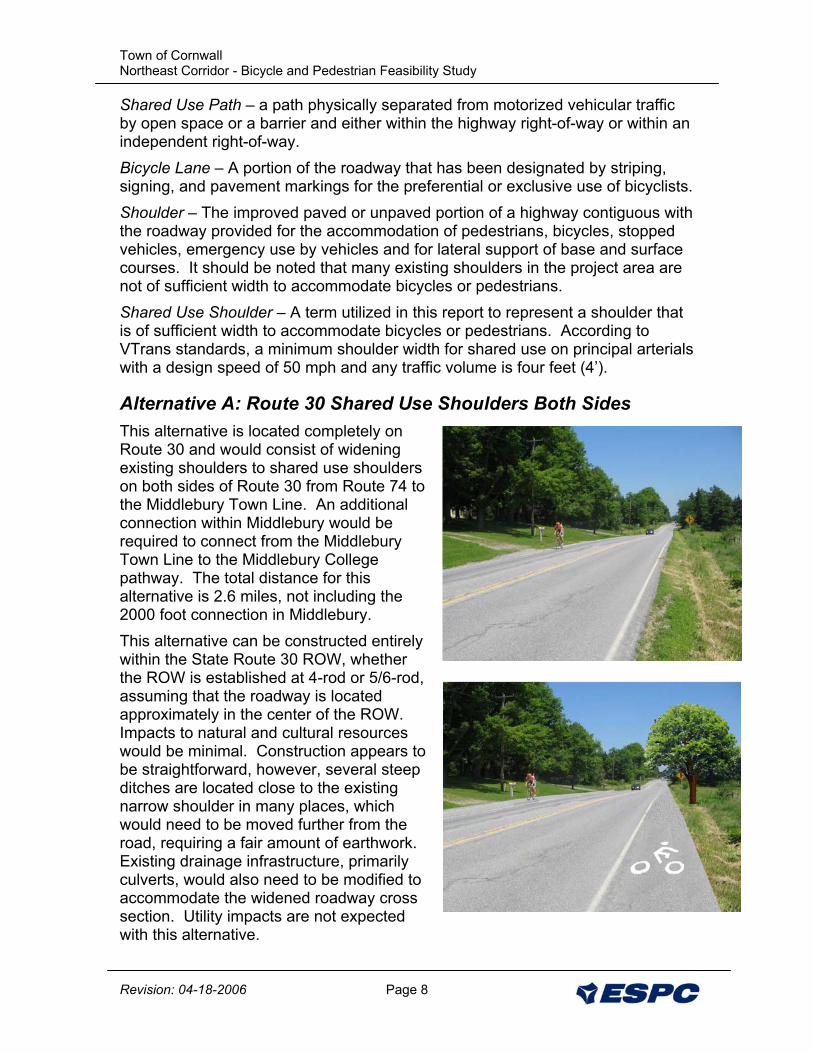
Alternative A: Route 30 Shared Use Shoulders Both Sides This alternative is located completely on Route 30 and would consist of widening existing shoulders to shared use shoulders on both sides of Route 30 from Route 74 to the Middlebury Town Line. An additional connection within Middlebury would be required to connect from the Middlebury Town Line to the Middlebury College pathway. The total distance for this alternative is 2.6 miles, not including the 2000 foot connection in Middlebury. This alternative can be constructed entirely within the State Route 30 ROW, whether the ROW is established at 4-rod or 5/6-rod, assuming that the roadway is located approximately in the center of the ROW. Impacts to natural and cultural resources would be minimal. Construction appears to be straightforward, however, several steep ditches are located close to the existing narrow shoulder in many places, which would need to be moved further from the road, requiring a fair amount of earthwork. Existing drainage infrastructure, primarily culverts, would also need to be modified to accommodate the widened roadway cross section. Utility impacts are not expected with this alternative.
Town of Cornwall Northeast Corridor - Bicycle and Pedestrian Feasibility Study
Revision: 04-18-2006 Page 9
The drainage generally sheets off of the east and south sides of Route 30, and is collected in drainage swales along the north and west sides of Route 30, periodically culverted under Route 30. This alternative will require high attention to the drainage patterns along Route 30 and will require the relocation of swales and culverts to maintain these patterns. The drawbacks associated with this alternative are that it does not separate the pedestrian from the roadway and a wider roadway could promote increased traffic speeds. Several residents have expressed preference to a separated shared use pathway rather than widened shoulders for shared use shoulders.
Preferred Cross Section The preferred cross section (as shown in Appendix B of this report) would consist of preferred 4’ shared use shoulders on both sides of the road, with preferred adjacent slopes of 4 to 1 or less. The shared use shoulders can be constructed a minimum of 3’ wide, with maximum adjacent slopes of 3 to 1.
Maintenance The future maintenance of this pathway (snow removal, repaving) would be included with the maintenance of Route 30.
Viability This option is a viable alternative providing a connection from Cornwall Center to Middlebury Downtown. It satisfies the Purpose and Need Statement and thus far has received public support. This alignment would be eligible to receive funding through the Scenic Byways Program, but not the Vermont Bicycle and Pedestrian Program or Enhancements Program.
Cost The cost of this project assuming 4’ wide shoulders on both sides of Route 30 from the Cornwall Town Hall to the Middlebury Town Line is approximately $2.8 million. This does not include property acquisition (if necessary).
Alternative B: Shared Use Path Parallel to Route 30 This alternative is located adjacent to Route 30 and would consist of a 10’ wide shared use pathway from Route 74 to the Middlebury Town Line. An additional connection from the town line into Middlebury would be required to continue the connection to the Middlebury College pathway. The pathway would be best suited along the southeast side of Route 30. The southeast side of the roadway has the least physical barriers and would provide direct connections to Cornwall Town Hall, Cornwall Elementary School, Morse Road, and the Middlebury College Pathway. The total distance for this alternative is 2.6 miles, not including the 2000 foot connection in Middlebury. Additional research would be required to determine whether this alignment would fall completely within the highway ROW, or if property acquisition would be necessary. If it is determined that a 4-rod ROW is present along Route 30, then
Town of Cornwall Northeast Corridor - Bicycle and Pedestrian Feasibility Study
Revision: 04-18-2006 Page 10
it is likely that temporary construction easements, or permanent ROW acquisition would be required. If the 5 and 6-rod ROWs exist, then it is very likely that the pathway can be constructed completely within the ROW and easements or ROW acquisition would not be required. There is a slightly increased potential for impacts to natural resources, particularly surface waters and wetlands, as compared to Alternative A, although the potential impact is expected to be minimal, with the alignment on the east and south sides of Route 30. A potential Class III wetland is located 30 feet from the road near the Middlebury town line (Area E in Arrowwood’s report), that would need to be delineated. There does not appear to be a significant potential to impact cultural resources as long as the pathway remains close to Route 30, as indicated in the typical cross sections, and as long as the pathway remains on the south and east sides of Route 30. Utility impacts are not expected with this alternative. Several culverts will need to be relocated, and drainage channels modified, but there are no physical barriers, with the exception of trees and brush that would prevent the construction of this alternative on the southeast side of Route 30. The main drawback associated with this alignment is the impact to adjacent properties (loss of vegetation, front yards). The alignment has been proposed several times in the past, and impacted residents have shown enough resistance to halt the further planning of this option. Although, this alternative would have a significant benefit (separates pedestrians from the roadway, and connects to the defined origins and destinations) of all of the proposed alternatives along Route 30.
Preferred Cross Section The preferred cross section (as shown in Appendix B of this report) is a 10’ wide shared use pathway with a 5’ minimum separation from Route 30, with adjacent slopes of 4 to 1 or less. The shared use pathway can be constructed a minimum of 8’ wide, with maximum adjacent slopes of 3 to 1.
Town of Cornwall Northeast Corridor - Bicycle and Pedestrian Feasibility Study
Revision: 04-18-2006 Page 11
Maintenance The future maintenance of this pathway (snow removal, repaving) will need to be done separately from Route 30. For snow removal it is possible to use sidewalk plows, trucks with plow attachments, or outsource the work to a private contractor.
Viability This option is viable depending on where the limits of the State ROW are. However an effort to gain the support of adjacent landowners is recommended prior to proceeding with final design / construction. This alternative meets the Purpose and Need Statement. This alignment would be eligible to receive funding through the Vermont Bicycle and Pedestrian Program, Enhancements Program, or Scenic Byways Program.
Cost The cost of this project assuming a 10’ wide off road paved pathway from the Cornwall Town Hall to the Middlebury Town Line is approximately $2.9 million. This does not include property acquisition (if necessary).
Alternative C: Shared Use Path – Morse Road to Route 30 Alternative C consists of an off-road shared use pathway from Morse Road to Route 30 near the Middlebury Town Line. An additional connection within Middlebury would be required to connect from the Middlebury Town Line to the Middlebury College pathway, and the alternative would need to be combined with Segment 1 (see summary map in Appendix B) of either Alternative A or B to connect Cornwall Center. The total distance for this alternative is 3.2 miles, not including the 2000 foot connection in Middlebury. The majority of this alternative would be constructed away from Route 30 on the properties bordering Middlebury Swamp. There is a significant potential for impact to both natural and cultural resources. The Middlebury Swamp is a large mapped wetland with significant natural communities, rare plant species, and important wildlife habitat and Arrowwood has recommended keeping the pathway away from the swamp. According to the ARA there are likely to be multiple areas sensitive for pre-contact Native American sites in this area, particularly along the edges of the Middlebury Swamp. Additional investigation would be required and there is a high potential for impact. Utility impacts are not expected with this alternative. Drainage and construction access would be a large consideration for this alternative, but there are no physical barriers that would prevent its construction.
Town of Cornwall Northeast Corridor - Bicycle and Pedestrian Feasibility Study
Revision: 04-18-2006 Page 12
The main drawback associated with this alignment is the impact to the properties it crosses and the permits necessary to do so. Also due to the saturated ground in this area it would be better suited as an unpaved pathway so that the maintenance of the asphalt due to the freeze/thaw cycle does not become a burden. This alternative does not provide a connection to Cider Mill Road and Ridge Road. The segment of pathway along Morse Road is unpaved, which would not meet the needs of bicyclists. Coordination with landowners who have fenced properties for the grazing of animals in this area would be a high priority. It is possible to install a “maze gate” that would allow pedestrian access but keep large animals in. Swinging gates have too much potential for pedestrians to leave them open.
Preferred Cross Section The preferred cross section (as shown in Appendix B of this report) is a 10’ wide shared use pathway, with adjacent slopes of 4 to 1 or less. The shared use pathway can be constructed a minimum of 8’ wide, with maximum adjacent slopes of 3 to 1.
Maintenance The future maintenance of this pathway (snow removal, repaving) will need to be done separately from Route 30. For snow removal it is possible to use sidewalk plows, trucks with plow attachments, or outsource the work to a private contractor. If the path is not to be used for bicycles year round, the snow can be left on it and the path can be used for snow shoeing and cross country skiing. If this option is pursued linkage to other cross country trails should be considered.
Viability This option would be a viable alternative if landowners in this area were to agree to allow the pathway to be aligned sufficiently to the west to avoid natural and cultural resource constraints in the vicinity of Middlebury Swamp and if the surface is unpaved. However, this alternative would not meet the Purpose and Need Statement as it would not provide a paved alignment for bicyclists and does not provide a connection to Cider Mill Road and Ridge Road. This alignment would be eligible to receive funding through the Vermont Bicycle and Pedestrian Program, Enhancements Program, or Scenic Byways Program.
Cost The cost of this project assuming an 10’ wide off road paved pathway from the Morse Road to Route 30 at the Middlebury town line is approximately $1.8 million. Including Segment 1 from Alternative B would result in a total project cost of $2.3 million. This does not include property acquisition (if necessary), nor any paving of Morse Road.
Town of Cornwall Northeast Corridor - Bicycle and Pedestrian Feasibility Study
Revision: 04-18-2006 Page 13
Alternative D: Shared Use Path – Robbins Road to Andrus Pitch Alternative D consists of an off-road unpaved shared use pathway from Robbins Road to Andrus Pitch (which connects to Route 30). This alternative would need to be combined with Segment 1, 2, and 5 of either Alternative A or B in order to be effective and to meet the Purpose and Need Statement. This alternative would use the existing low traveled Robbins Road and Andrus Pitch and would provide a short connection between the two of approximately 1,300 ft. According to the natural and cultural resource assessments conducted, this option does not present any significant impacts to natural or cultural resources. Utility impacts are not expected with this alternative. See Alternatives A and B for Segments 1, 2, and 5. There are no physical barriers that would prevent this alternative’s construction. The total distance for this alternative is 2.85 miles, not including the 2000 foot connection in Middlebury. The principal downside associated with this alignment is the impact to the properties it crosses and the ROW acquisition that would be required. Also, this alternative does not provide a connection to Cider Mill Road and Ridge Road, and proposes to use unpaved roadways to connect (Robbins Road and Andrus Pitch). Coordination with landowners who have fenced properties for the grazing of animals in this area would be a high priority. It is possible to install a “maze gate” that would allow pedestrian access but keep large animals in. Swinging gates have too much potential for pedestrians to leave them open.
Preferred Cross Section The preferred cross section (as shown in Appendix B of this report) is a 10’ wide shared use pathway, with adjacent slopes of 4 to 1 or less. The shared use pathway can be constructed a minimum of 8’ wide, with maximum adjacent slopes of 3 to 1.
Maintenance The future maintenance of this pathway (snow removal, surfacing) will need to be done separately from Route 30. For snow removal it is possible to use sidewalk plows, trucks with plow attachments, or outsource the work to a private contractor.
Viability This option is viable depending upon the acceptance of the landowners. This alternative does not meet the Purpose and Need Statement as it does not
Town of Cornwall Northeast Corridor - Bicycle and Pedestrian Feasibility Study
Revision: 04-18-2006 Page 14
provide a paved alignment for bicyclists and does not provide a connection to Cider Mill Road and Ridge Road. This alignment would be eligible to receive funding through the Vermont Bicycle and Pedestrian Program, Enhancements Program, or Scenic Byways Program.
Cost The cost of this project assuming an 10’ wide off road paved pathway from the Andras Pitch to Route 30 is approximately $921,888. Including Segment 1, 2, and 5 from Alternative B would result in a total project cost of $2.5 million. This does not include property acquisition (if necessary), nor any paving of Robbins Road and Andrus Pitch.
Alternative E: Route 125 Shared Use Shoulders Both Sides Alternative E is located completely on Route 125 and would consist of the construction of shared use shoulders on both sides of the highway from Cider Mill Road to the Middlebury Town Line. An additional connection within Middlebury would be required to connect from the Middlebury Town Line to the Middlebury College pathways. The total distance for this alternative is approximately 1 mile, not including the 2000 foot connection in Middlebury. This alternative can be constructed entirely within the State Route 125 ROW meaning that permanent easements would not be required. The potential of impact to natural or cultural resources is expected to be low. Route 125 crosses a small stream through this alignment, which would require extension of the culvert, and ditches along the road side would need to be moved. Utility impacts are not expected with this alternative. The drawbacks associated with this alternative are that it does not separate the pedestrian from the roadway and a wider roadway could promote increased traffic speeds.
Preferred Cross Section The preferred cross section (as shown in Appendix B of this report) would consist of 4’ shared use shoulders on both sides of the road, with preferred adjacent slopes of 4 to 1 or less. The shared use shoulders can be constructed a minimum of 3’ wide, with maximum adjacent slopes of 3 to 1.
Maintenance The future maintenance of this pathway (snow removal, repaving) can be included with the maintenance of Route 125.
Town of Cornwall Northeast Corridor - Bicycle and Pedestrian Feasibility Study
Revision: 04-18-2006 Page 15
Original Photo by Julia Randall
Viability This option is viable, and meets the Purpose and Need Statement. Although, this alternative would not be eligible for funding through the VTrans Bicycle and Pedestrian Program or Enhancements Program.
Cost The cost of this project assuming 4’ wide shoulders on both sides of Route 125 from Cider Mill Road to the Middlebury Town Line is approximately $1.0 million. This does not include property acquisition (if necessary).
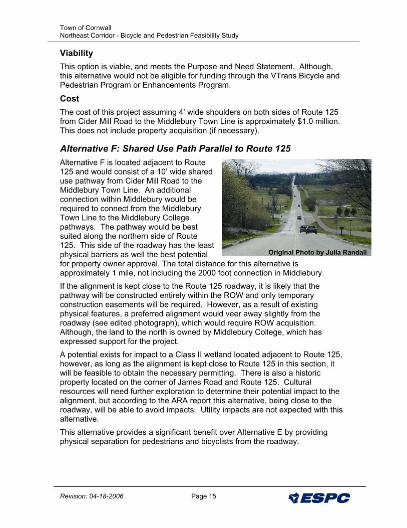
Alternative F: Shared Use Path Parallel to Route 125 Alternative F is located adjacent to Route 125 and would consist of a 10’ wide shared use pathway from Cider Mill Road to the Middlebury Town Line. An additional connection within Middlebury would be required to connect from the Middlebury Town Line to the Middlebury College pathways. The pathway would be best suited along the northern side of Route 125. This side of the roadway has the least physical barriers as well the best potential for property owner approval. The total distance for this alternative is approximately 1 mile, not including the 2000 foot connection in Middlebury. If the alignment is kept close to the Route 125 roadway, it is likely that the pathway will be constructed entirely within the ROW and only temporary construction easements will be required. However, as a result of existing physical features, a preferred alignment would veer away slightly from the roadway (see edited photograph), which would require ROW acquisition. Although, the land to the north is owned by Middlebury College, which has expressed support for the project. A potential exists for impact to a Class II wetland located adjacent to Route 125, however, as long as the alignment is kept close to Route 125 in this section, it will be feasible to obtain the necessary permitting. There is also a historic property located on the corner of James Road and Route 125. Cultural resources will need further exploration to determine their potential impact to the alignment, but according to the ARA report this alternative, being close to the roadway, will be able to avoid impacts. Utility impacts are not expected with this alternative. This alternative provides a significant benefit over Alternative E by providing physical separation for pedestrians and bicyclists from the roadway.
Town of Cornwall Northeast Corridor - Bicycle and Pedestrian Feasibility Study
Revision: 04-18-2006 Page 16
Preferred Cross Section The preferred cross section (as shown in Appendix B of this report) is a 10’ wide shared use pathway with a 5’ separation from Route 30, with adjacent slopes of 4 to 1 or less. The shared use pathway can be constructed a minimum of 8’ wide, with maximum adjacent slopes of 3 to 1.
Maintenance The future maintenance of this pathway (snow removal, repaving) will need to be done separately from Route 125. For snow removal it is possible to use sidewalk plows, trucks with plow attachments, or outsource the work to a private contractor. Middlebury College has shown potential interest in plowing the pathway so long as it is not needed to be done the same day as a storm (so they can plow the main campus pathways first).
Viability This alternative is viable, and would be eligible to receive funding through the Bicycle and Pedestrian Program or the Enhancements Program. This alternative meets the Purpose and Need Statement.
Cost The cost of this project assuming an 10’ wide off road paved pathway from Cider Mill Road to the Middlebury Town Line is approximately $1.1 million. This does not include property acquisition (if necessary).
Alternative G: Shared Use Path – Route 30 to James Road This alternative consists of an off-road shared use pathway from Route 125 to James Road following the property borders of Middlebury College. An additional connection within Middlebury would be required to connect from the Middlebury Town Line to the Middlebury College pathways, and the alternative would need to be combined with Segment 10 of either Alternative E or F. If this alternative were selected it would be recommended to combine it with Alternative F to maintain consistency (they are both shared use paths). The total distance for this alternative is approximately 1.4 miles, not including the 2000 foot connection in Middlebury. This majority of this alternative would be constructed away from Route 125, though agricultural fields. There is a potential for impacts to natural resources, namely wetlands. A small Class III wetland was potentially identified in the vicinity of the alignment, which would need to be delineated during the design
Town of Cornwall Northeast Corridor - Bicycle and Pedestrian Feasibility Study
Revision: 04-18-2006 Page 17
phase. According to Arrowood’s report, as long as the alignment stays in the agricultural field as currently proposed, impacts are expected to be minimal. Potential impact to cultural resources would also need to be further investigated as the area in the vicinity of the path, particularly on habitable landforms adjacent to Ledge Creek would be sensitive to archeological impacts. Utility impacts are not expected with this alternative. Cornwall residents appear to be very supportive of this alternative. This alternative does not provide a direct connection to Cider Mill Road however it can easily be accessed from James Road. And there have been discussions within the Town about the acquisition of property on the west side of James Road to construct a pathway that would connect James Road to Lemon Fair Road. This alternative is very aesthetically pleasing with grand views into Middlebury, and a scenic path through a diverse butterfly habitat, and provides a safe route for bicyclists and pedestrians.
Preferred Cross Section The preferred cross section (as shown in Appendix B of this report) is a 10’ wide shared use pathway, with adjacent slopes of 4 to 1 or less. The shared use pathway can be constructed a minimum of 8’ wide, with maximum adjacent slopes of 3 to 1.
Maintenance The future maintenance of this pathway (snow removal, repaving) will need to be done separately from Route 30. For snow removal it is possible to use sidewalk plows, trucks with plow attachments, or outsource the work to a private contractor. Middlebury College has shown potential interest in plowing the pathway so long as it is not needed to be done the same day as a storm (so they can plow the main campus pathways first).
Viability This alternative is viable, and would be eligible to receive funding through the Bicycle and Pedestrian Program or the Enhancements Program provided Middlebury College is in agreement. This alternative meets the Purpose and Need Statement.
Cost The cost of this project assuming a 10’ wide off-road paved pathway from James Road to Route 125 is approximately $0.9 million. Adding segment 10 of Alternative F brings the total project cost to approximately $1.5 million. This does not include property acquisition (if necessary).
VIII. Preliminary Project Cost Estimate A construction cost estimate by segment has been included in Appendix C of this report. Estimated costs do not include property acquisition. Costs assume the project will follow VTrans requirements. Construction costs are based on the
Town of Cornwall Northeast Corridor - Bicycle and Pedestrian Feasibility Study
Revision: 04-18-2006 Page 18
current available construction cost data and the VTrans Report on Shared-Use Path and Sidewalk Unit Costs (Updated February 10, 2006). As displayed in the summary of costs in Appendix C, the total project costs include the construction estimate, engineering costs (20% of construction), municipal project management (10% of construction and engineering), construction inspection (10% of construction), and a 15% contingency of the construction costs. As indicated the projected costs do not include the cost of ROW acquisition. The engineering costs do include costs for a survey and reasonable ROW research; however, there is evidence of a conflicting ROW width along Route 30. If it becomes necessary to utilize the historic 5 or 6 rod ROW along Route 30, there is a high potential for the need to conduct extensive research and possible legal fees. The costs associated with establishing the Route 30 ROW unfortunately cannot be estimated at this time, although it would not be unreasonable to expect the design costs to increase from 20% to 25-30% for the segments along Route 30, particularly for Alternative B.
Funding Sources In general as the Steering Committee moves forward in seeking funding for the construction of an alternative the following will need to be provided:
1) All funding sources will need to see the final plan for the alignment. If it appears that the path leads to nowhere (i.e. a segment of an alignment) it will be more difficult to obtain funding. Threrfore it will be important to show how the other needed segments will be constructed (i.e. connections to Middlebury).
2) Some funding sources may be capable of providing funds to complete the project all at once (i.e. Scenic Byway Program) while others will allow a phased approach (i.e. Vermont Enhancements Program). ESPC recommends coordinating with the agency responsible for administering the grants prior to submitting an application and determining the best approach for obtaining funding from the particular program.
Scenic Byway Program - Route 30 is currently in the process of becoming a Scenic Byway, which is a potential source of funding. The Scenic Byway program has funds to construct projects that improve the access or aesthetics within a one mile corridor of the designated route. All of the alternatives along Route 30 qualify for this funding. Enhancements Program – This program distributes Federal Grants (typically with a match from Town sources). The program will consider any bicycle/pedestrian system (including widened shoulders for shared use shoulders), however the program will typically place priority on projects that are separated facilities from roads, and has the support of impacted property owners.
Town of Cornwall Northeast Corridor - Bicycle and Pedestrian Feasibility Study
Revision: 04-18-2006 Page 19
Private Donors – Middlebury College, the Town of Middlebury, and interested landowners all represent potential sources of funding for the development of all of the alternatives.
IX. Compatibility with Planning Efforts In general the Town of Cornwall plans include providing better non-vehicular access for its residents and visitors to the beautiful rural areas with Cornwall, and to provide a non-vehicular link with Cornwall Center and Downtown Middlebury. The State of Vermont does not currently have plans for the repaving or widening of either Route 30 or Route 125. This project is consistent with the bike routes designated by Lake Champlain Bikeways (see map in Appendix H).
X. Project Time Line This time line is largely dependent upon the acceptance of the local residents of the preferred alternative, the length of the project phase proposed, availability of funding, and the ease of permitting, town, and state approval. The design phase can be reduced significantly, and have construction complete by the end of 2007 if town, state and permitting agency approval is unhindered. Alternative Selected for First Phase Development April , 2006 *Coordination with Landowners / Funding Acquisition Begins May, 2006 Coordination Complete / Funding Attained July, 2006 Design Phase Request for Proposals August, 2006 Design Phase Begins September, 2006 Contract Plans / Design Complete October, 2007 Construction Phase Request for Proposals January, 2008 Contractor Selected February, 2008 Construction Begins April, 2008 Construction Complete November, 2008 * Note that coordination with landowners is not a required step, but is recommended by ESPC.
XI. Recommended Alternatives Based on the results of this study, it is ESPC’s recommendation that the following alternative(s) be pursued. ESPC believes that these alternatives best meet the Purpose and Need statement, Natural and Cultural Resource constraints, ROW constraints, and likelihood of future public support.
Town of Cornwall Northeast Corridor - Bicycle and Pedestrian Feasibility Study
Revision: 04-18-2006 Page 20
Alternatives Along or Connecting to Route 30 ESPC has evaluated four alignments for the pathway that would connect Cornwall Center to Downtown Middlebury and has determined that the preferred alignment for this portion of the study area is Alternative B – a shared use pathway along the south and east sides of Route 30. It should be noted, however, that although Alternative B is the preferred alignment based on best meeting the Purpose and Need of the Project, its true viability will depend on the outcome of further right-of-way research and surveying to determine if the project can be constructed completely within the ROW. This is due to the opposition expected by adjacent landowners and likely associated difficulty to acquire permanent ROW or construction easements if this becomes necessary. Therefore, ESPC recommends pursuing Option B, pending the outcome of ROW research, which should be the first step in the design phase of the project. If following the ROW research, it is determined that insufficient ROW is available, or if a significant process, with an uncertain outcome, will be required to obtain the wider ROW, then it is recommended to revert to Alternative A, shared use shoulders, to proceed with in design and construction. Alternative A will still meet the Purpose and Need of the project, with minimal impacts, although it has the added drawbacks of not physically separating users from traffic and can undermine traffic calming efforts. From a funding perspective, this approach is feasible since both Alternatives A and B are relatively similar in cost, and switching from one alternative to the other at the beginning of the design, following the survey, will not have a significant impact on the budget or schedule of the project. Therefore, the total estimated cost for Alternative B or A would be $2.8 million to $2.9 million. Alternatives Along or Connecting to Route 125 ESPC evaluated three alignments for the pathway to connect northern Cornwall and points west to Downtown Middlebury and has determined that the recommended alignment for this section of the study area is Alternative G – a shared use pathway from James Road to the Middlebury College pathways. This alignment best meets the desires of Cornwall residents, and provides a scenic route to be enjoyed by outdoor enthusiasts. The alignment is located on Middlebury College property and the Route 125 ROW. There are currently plans (outside of this project) to develop a pathway on the western side of James Road connecting to Lemon Fair Road. Since Alternative G is located solely on Middlebury College and State Property, it makes obtaining letters of intent and seeking funding sources an easier task. Resource impacts are expected to be minimal, or the pathway alignment can be modified to avoid impacts, although additional investigation of wetlands and archeological resources will be required. Alternative G would need to be combined with a segment of Alternative E or F to connect to the Middlebury town line. It is recommended that a portion of
Town of Cornwall Northeast Corridor - Bicycle and Pedestrian Feasibility Study
Revision: 04-18-2006 Page 21
Alternative F be pursued as it is also for a shared use path. Therefore, the total cost for this recommendation would include the cost of Alternative G, plus the cost of Alternative F (segment 10 only), which results in approximately $1.5 million.