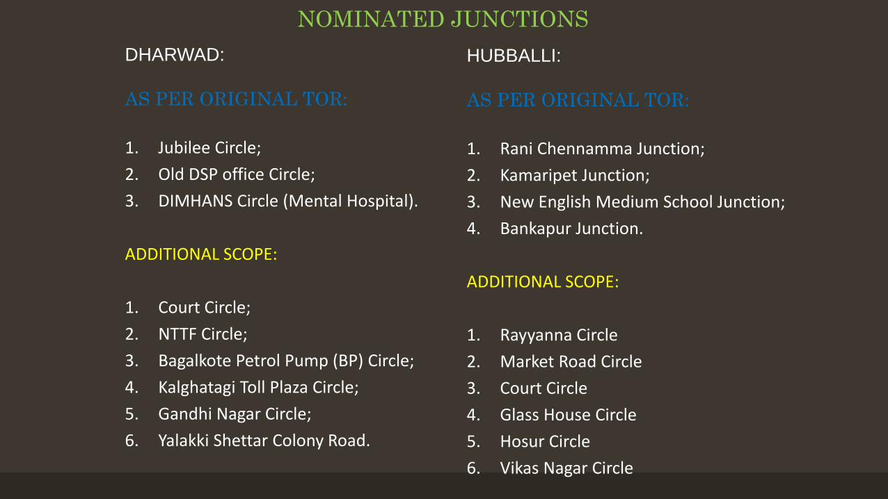
1. Rani Chennamma Junction;2. Kamaripet Junction;3. New English Medium School Junction;4. Bankapur Junction.
ADDITIONAL SCOPE:
1. Rayyanna Circle 2. Market Road Circle3. Court Circle 4. Glass House Circle 5. Hosur Circle 6. Vikas Nagar Circle
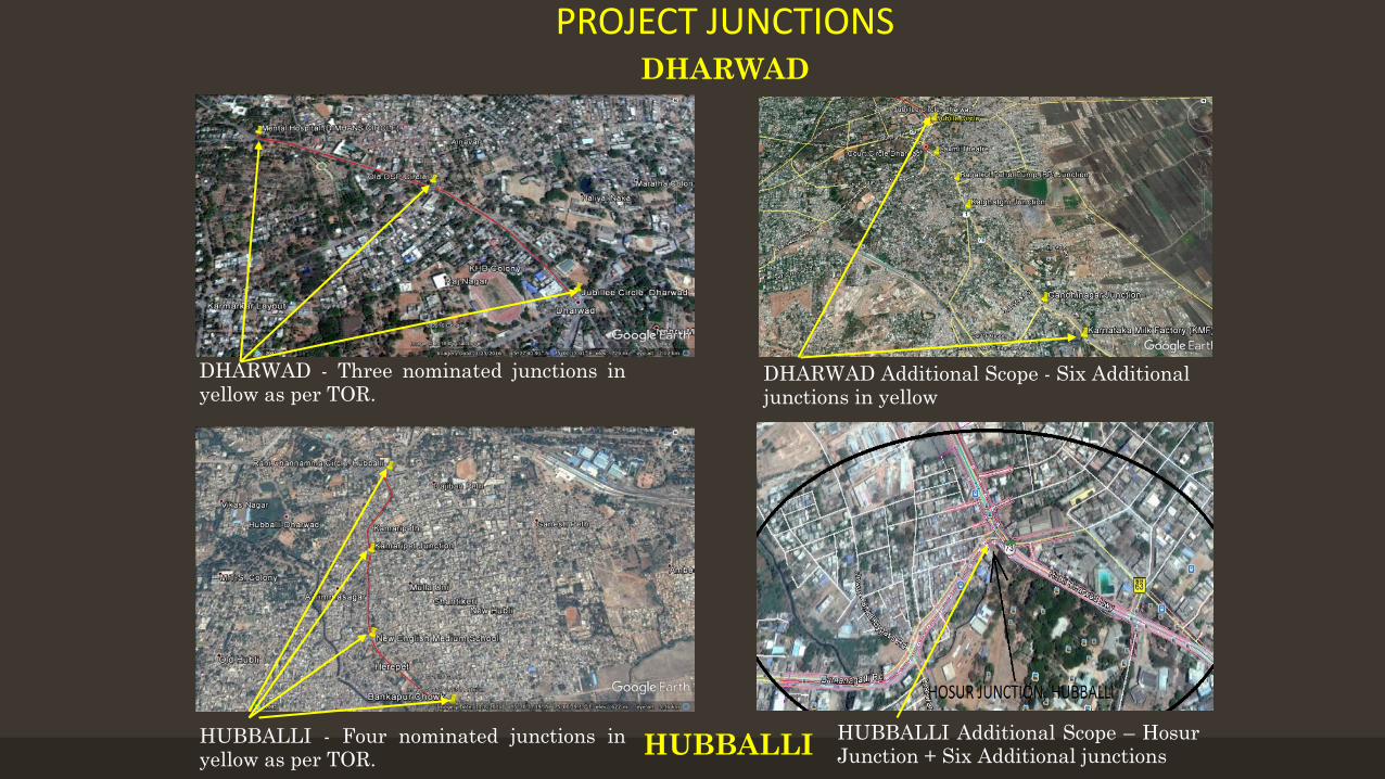
PROJECT JUNCTIONSDHARWAD
HUBBALLI
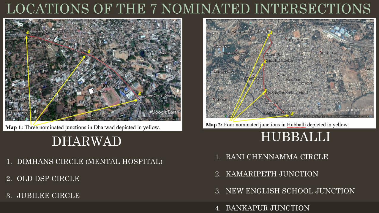
DHARWAD - Three nominated junctions inyellow as per TOR.
DHARWAD Additional Scope - Six Additionaljunctions in yellow
HUBBALLI - Four nominated junctions inyellow as per TOR.
HUBBALLI Additional Scope – HosurJunction + Six Additional junctions
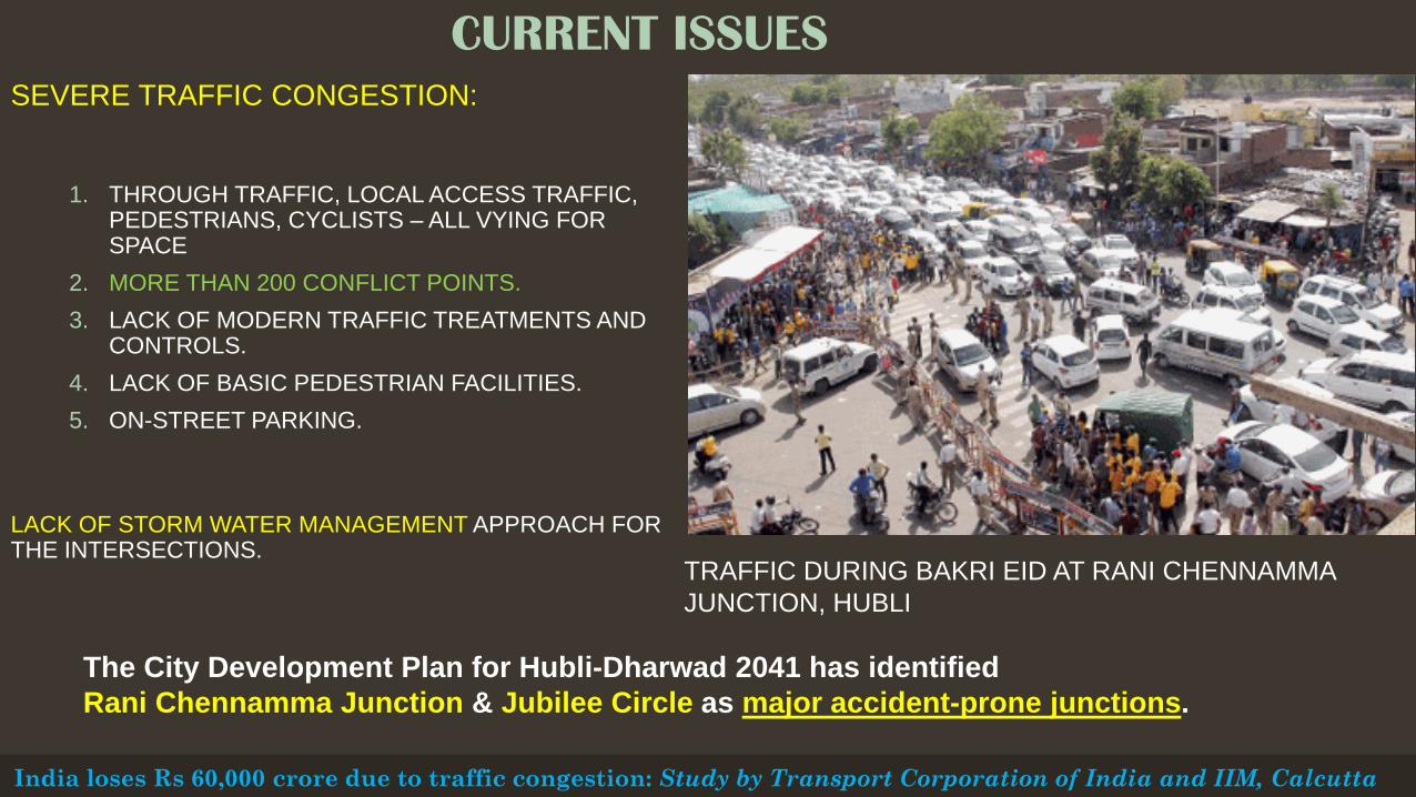
CURRENT ISSUESSEVERE TRAFFIC CONGESTION:
1. THROUGH TRAFFIC, LOCAL ACCESS TRAFFIC, PEDESTRIANS, CYCLISTS – ALL VYING FOR SPACE
2. MORE THAN 200 CONFLICT POINTS.3. LACK OF MODERN TRAFFIC TREATMENTS AND
CONTROLS.4. LACK OF BASIC PEDESTRIAN FACILITIES.5. ON-STREET PARKING.
LACK OF STORM WATER MANAGEMENT APPROACH FOR THE INTERSECTIONS.
India loses Rs 60,000 crore due to traffic congestion: Study by Transport Corporation of India and IIM, Calcutta
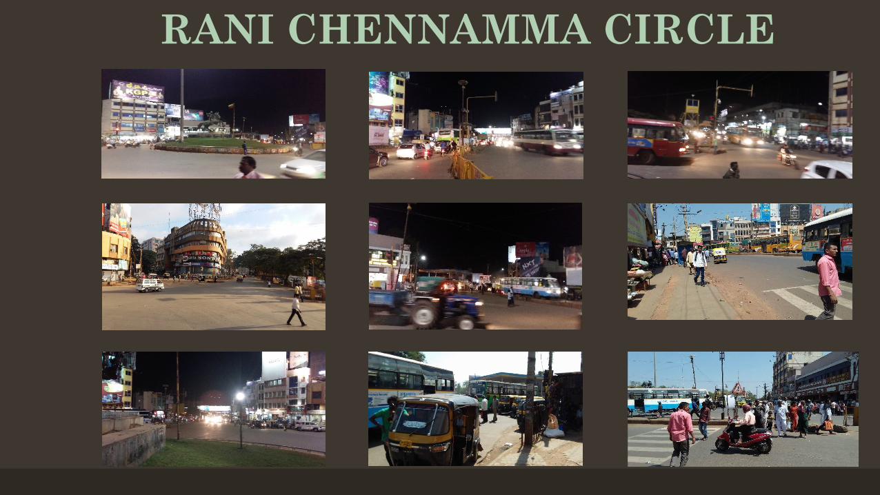
TRAFFIC DURING BAKRI EID AT RANI CHENNAMMA JUNCTION, HUBLI
The City Development Plan for Hubli-Dharwad 2041 has identified Rani Chennamma Junction & Jubilee Circle as major accident-prone junctions.
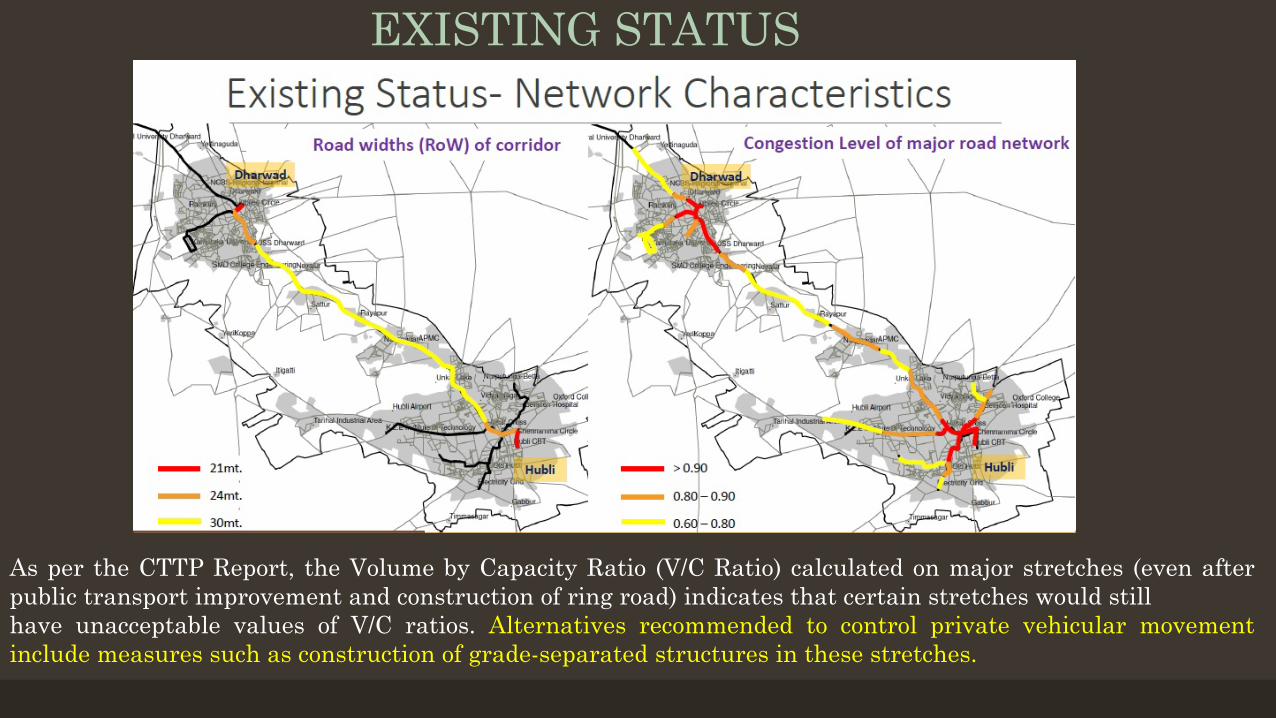
EXISTING STATUS
As per the CTTP Report, the Volume by Capacity Ratio (V/C Ratio) calculated on major stretches (even afterpublic transport improvement and construction of ring road) indicates that certain stretches would stillhave unacceptable values of V/C ratios. Alternatives recommended to control private vehicular movementinclude measures such as construction of grade-separated structures in these stretches.
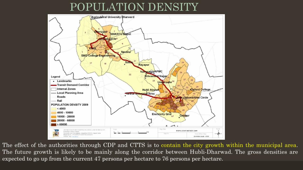
POPULATION DENSITY
The effect of the authorities through CDP and CTTS is to contain the city growth within the municipal area.The future growth is likely to be mainly along the corridor between Hubli-Dharwad. The gross densities areexpected to go up from the current 47 persons per hectare to 76 persons per hectare.
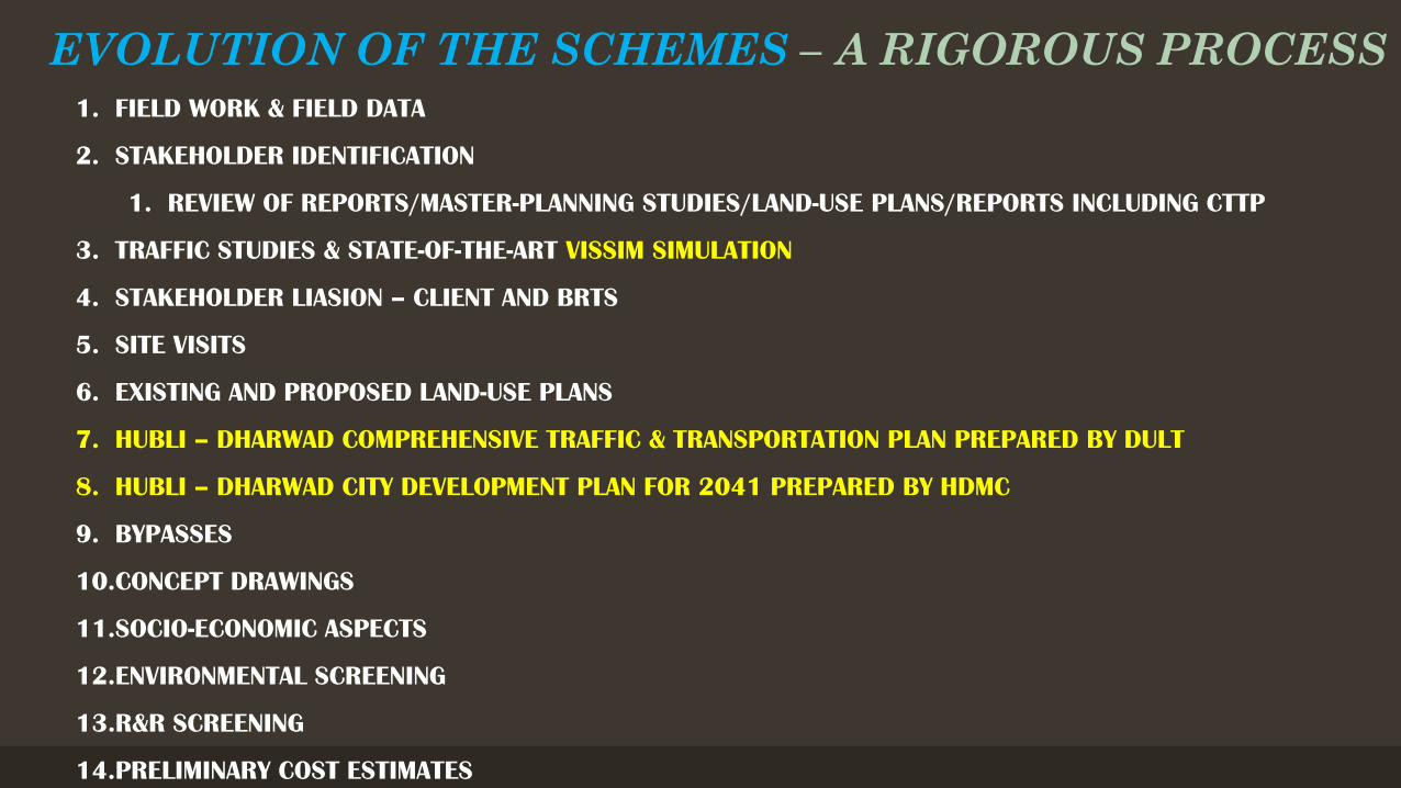
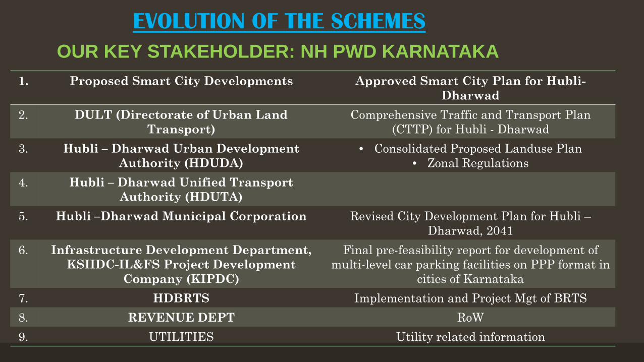
EVOLUTION OF THE SCHEMES – A RIGOROUS PROCESS1. FIELD WORK & FIELD DATA
2. STAKEHOLDER IDENTIFICATION
1. REVIEW OF REPORTS/MASTER-PLANNING STUDIES/LAND-USE PLANS/REPORTS INCLUDING CTTP
4. Hubli – Dharwad Unified Transport Authority (HDUTA)
5. Hubli –Dharwad Municipal Corporation Revised City Development Plan for Hubli –Dharwad, 2041
6. Infrastructure Development Department, KSIIDC-IL&FS Project Development
Company (KIPDC)
Final pre-feasibility report for development of multi-level car parking facilities on PPP format in
cities of Karnataka7. HDBRTS Implementation and Project Mgt of BRTS 8. REVENUE DEPT RoW9. UTILITIES Utility related information
OUR KEY STAKEHOLDER: NH PWD KARNATAKA
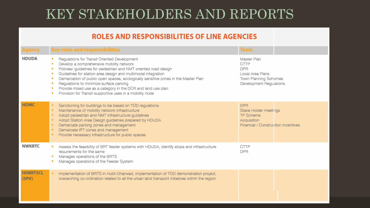
KEY STAKEHOLDERS AND REPORTS
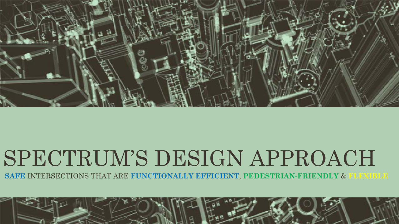
SPECTRUM’S DESIGN APPROACHSAFE INTERSECTIONS THAT ARE FUNCTIONALLY EFFICIENT, PEDESTRIAN-FRIENDLY & FLEXIBLE
FLYOVERS OR UNDERPASSES ? • At all the nominated intersections stipulated in the original TOR, Vehicular subways were
investigated for the principal major traffic directions identified from the traffic analyses.
Following were some of the adverse impacts and reasons that rendered these unfeasible:• Constraints on efficient geometrical arrangement for safe and efficient traffic operations – now and into the
future;• Urban space constraints for required carriageway widths, merging and demerging lanes;• Existing urban buildings in close vicinity and the impact on their foundations;• Subways investigated for Jubilee Circle (5-legged) and Rani Chennamma Junction (7-legged) do not address
the traffic problems and safety/functionality requirements warranted for such dangerous intersections.• Intersection drainage issues;• Sight distance and safety issues;• BRTS proposals
• At-grade intersections always have a potential for accidents due to conflicting crossing and turning vehicular movements, regardless of layout, signing and signalization. By separating the levels of intersecting roadways, both accidents and delays are reduced.
• Considering the above, flyovers as an option was investigated.
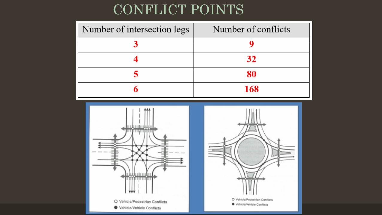
SAFETY ASPECTS - CONFLICT POINTSA conflict point is the point at which a road usercrossing, merging with, or diverging from a road ordriveway conflicts with another road user using thesame road or driveway. It is any point where the pathsof two through or turning vehicles diverge, merge, orcross.
CONFLICT POINTS
RANI CHENNAMMA CIRCLE
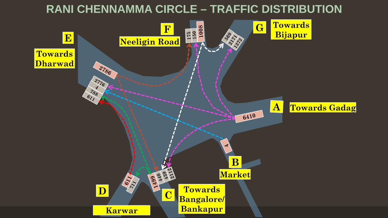
RANI CHENNAMMA CIRCLE – TRAFFIC DISTRIBUTION
FNeeligin Road
Towards Gadag
Towards Dharwad
EG Towards
Bijapur
D
Karwar
C Towards Bangalore/Bankapur
BMarket
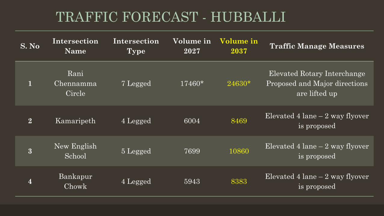
TRAFFIC FORECAST - HUBBALLI
S. No Intersection Name
Intersection Type
Volume in 2027
Volume in 2037 Traffic Manage Measures
1Rani
ChennammaCircle
7 Legged 17460* 24630*Elevated Rotary Interchange
Proposed and Major directions are lifted up
2 Kamaripeth 4 Legged 6004 8469 Elevated 4 lane – 2 way flyover is proposed
3 New English School 5 Legged 7699 10860 Elevated 4 lane – 2 way flyover
is proposed
4 Bankapur Chowk 4 Legged 5943 8383 Elevated 4 lane – 2 way flyover
is proposed
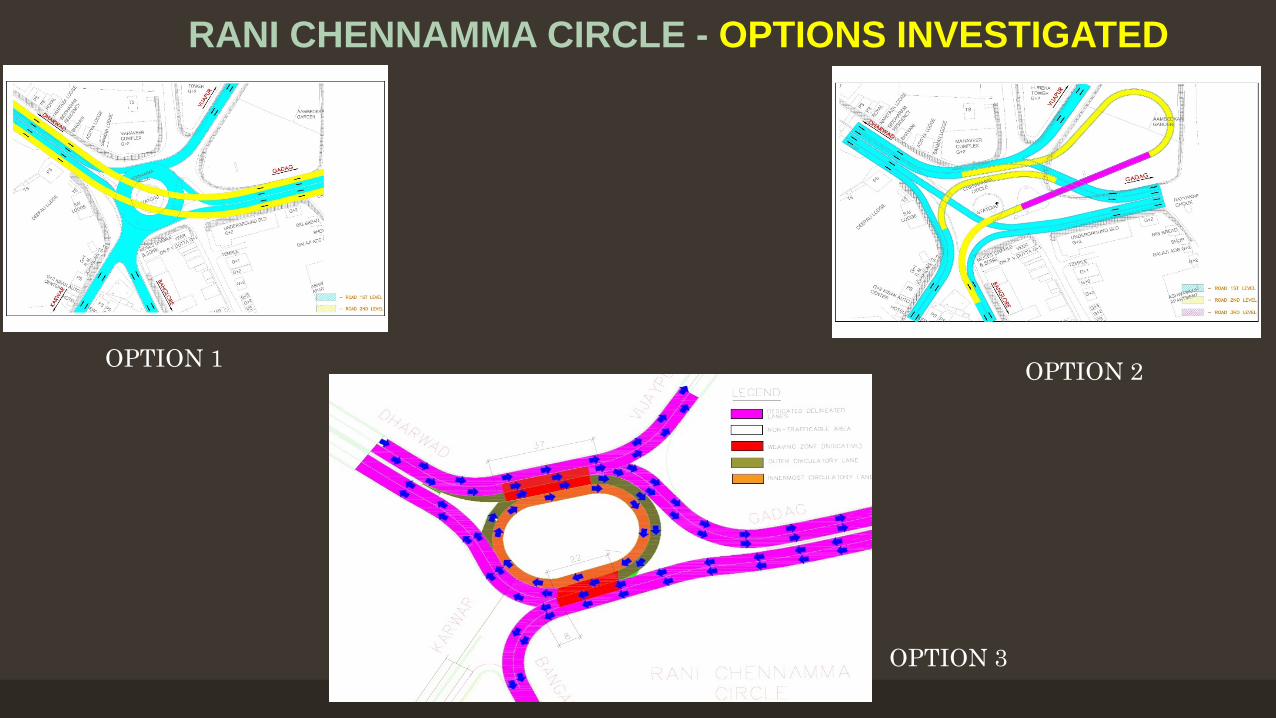
RANI CHENNAMMA CIRCLE - OPTIONS INVESTIGATED
OPTION 1 OPTION 2
OPTION 3
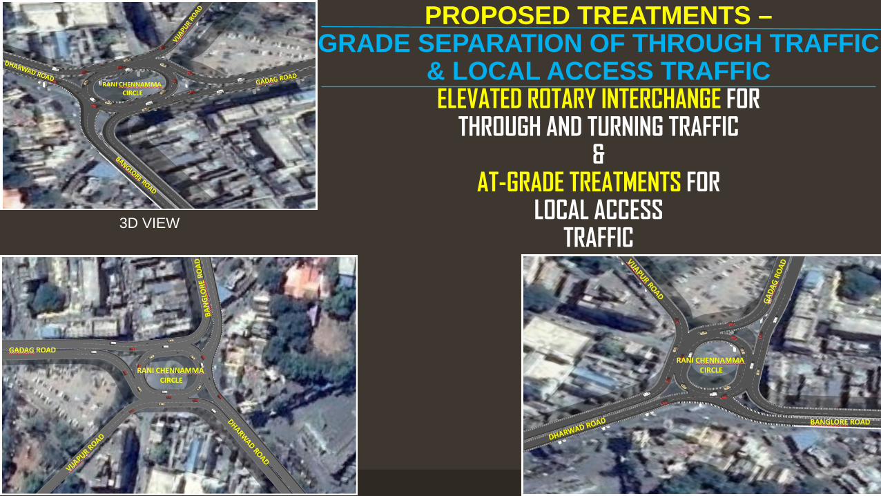
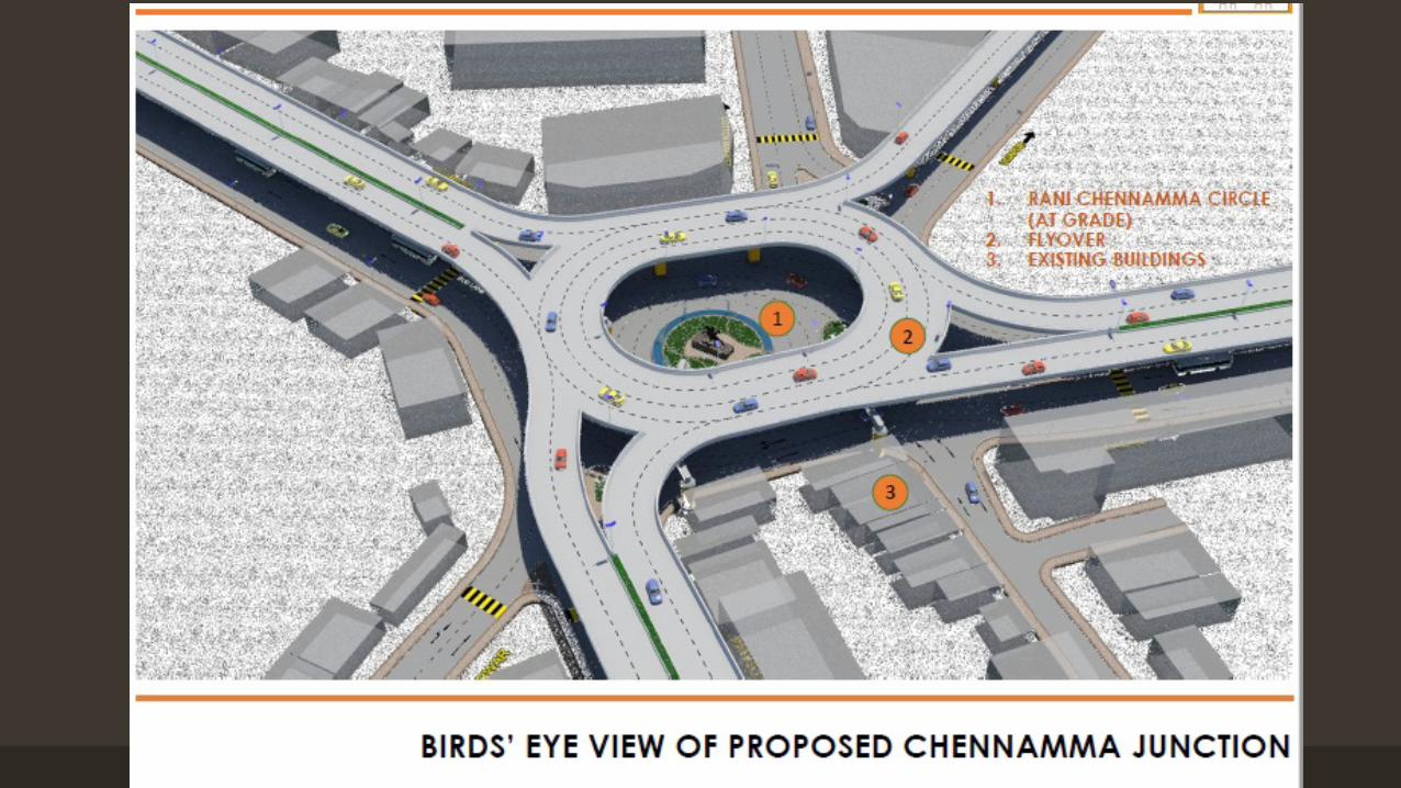
PROPOSED TREATMENTS –GRADE SEPARATION OF THROUGH TRAFFIC
& LOCAL ACCESS TRAFFICELEVATED ROTARY INTERCHANGE FOR
THROUGH AND TURNING TRAFFIC&
AT-GRADE TREATMENTS FOR LOCAL ACCESS
TRAFFIC3D VIEW
PLAN VIEW OF ELEVATED ROTARY
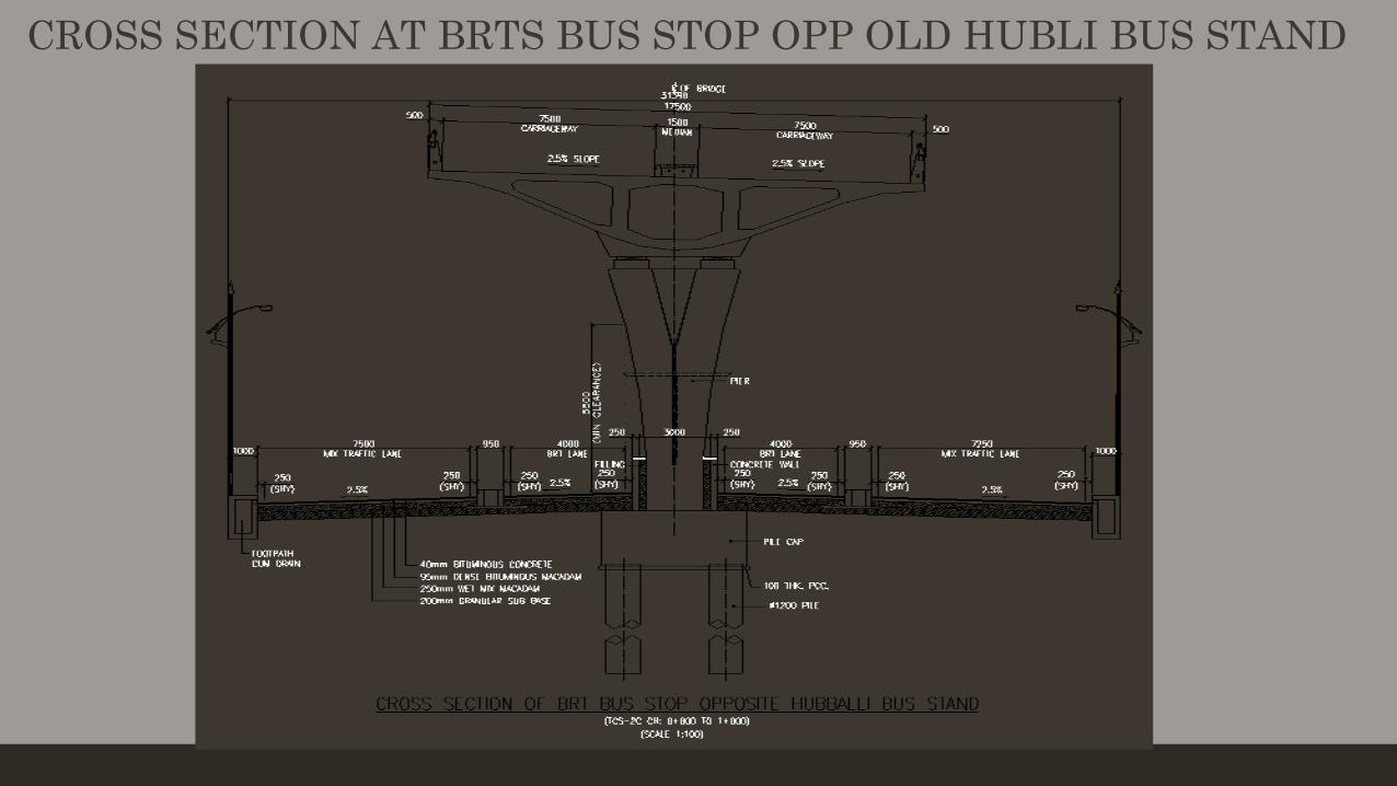
CROSS SECTION AT BRTS BUS STOP OPP OLD HUBLI BUS STAND
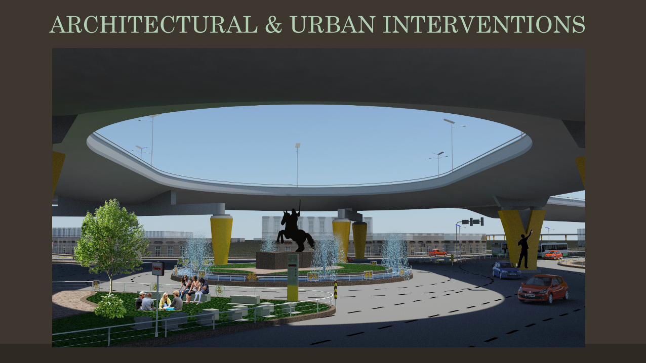
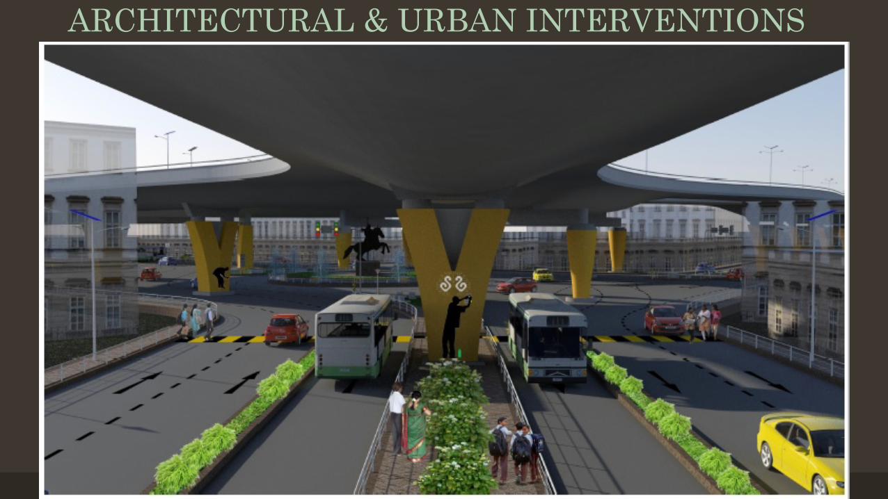
ARCHITECTURAL & URBAN INTERVENTIONS
ARCHITECTURAL & URBAN INTERVENTIONS
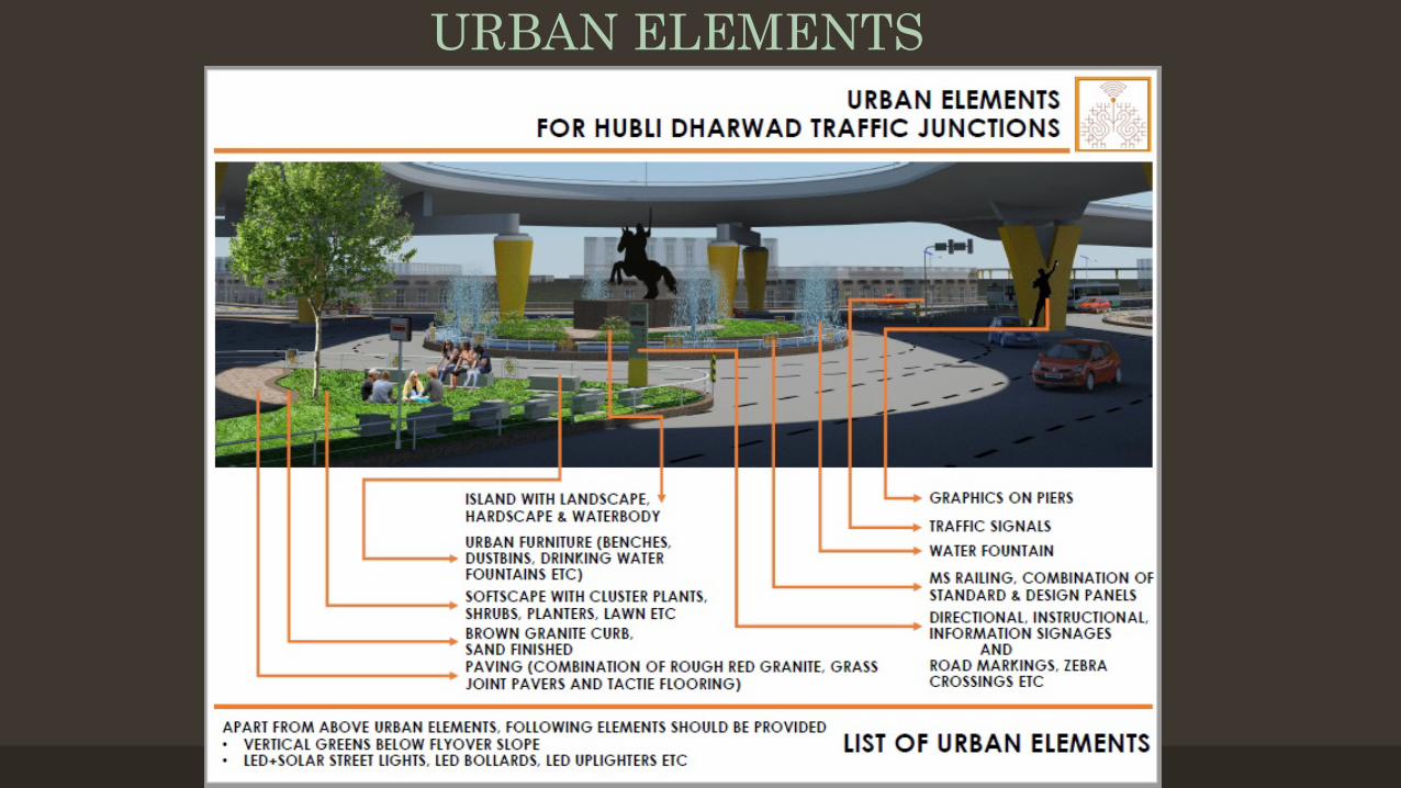
URBAN ELEMENTS
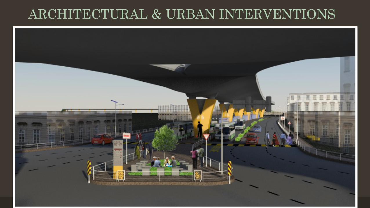
ARCHITECTURAL & URBAN INTERVENTIONS
ARCHITECTURAL & URBAN INTERVENTIONS
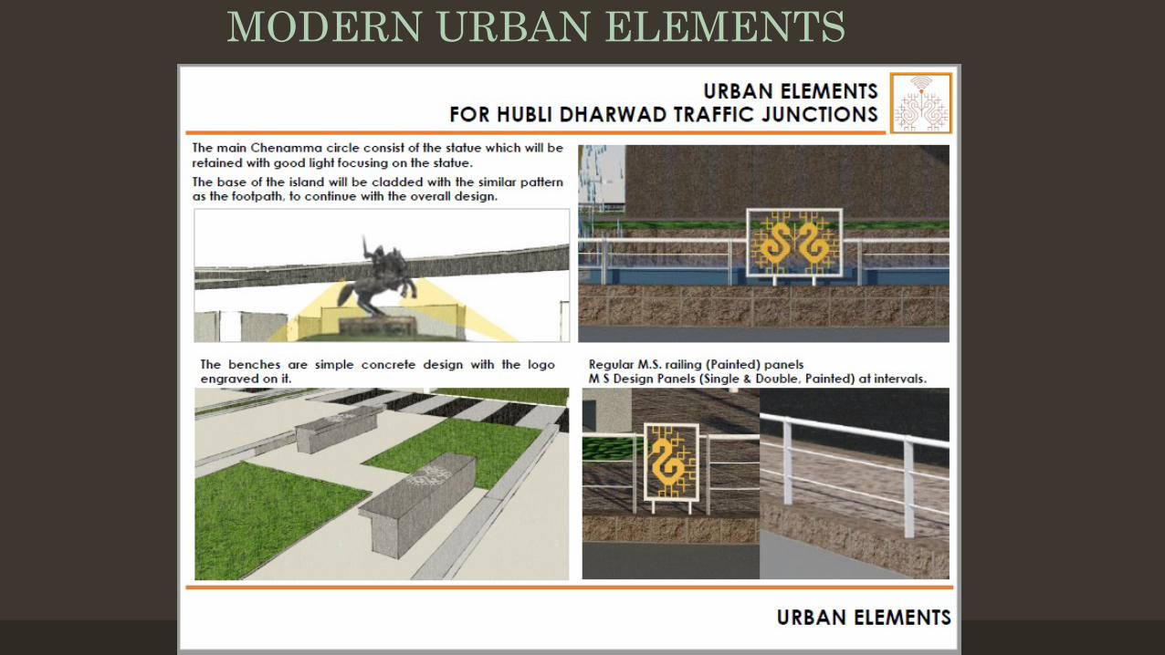
MODERN URBAN ELEMENTS
MODERN URBAN ELEMENTS
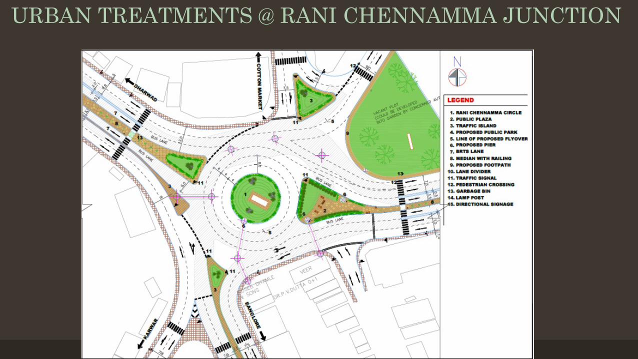
URBAN TREATMENTS @ RANI CHENNAMMA JUNCTION
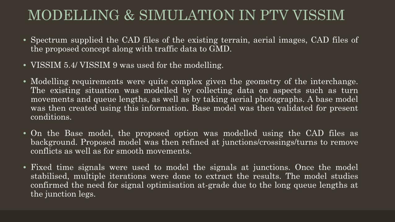
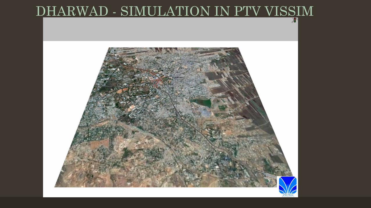
MODELLING & SIMULATION IN PTV VISSIM• Spectrum supplied the CAD files of the existing terrain, aerial images, CAD files of
the proposed concept along with traffic data to GMD.
• VISSIM 5.4/ VISSIM 9 was used for the modelling.
• Modelling requirements were quite complex given the geometry of the interchange.The existing situation was modelled by collecting data on aspects such as turnmovements and queue lengths, as well as by taking aerial photographs. A base modelwas then created using this information. Base model was then validated for presentconditions.
• On the Base model, the proposed option was modelled using the CAD files asbackground. Proposed model was then refined at junctions/crossings/turns to removeconflicts as well as for smooth movements.
• Fixed time signals were used to model the signals at junctions. Once the modelstabilised, multiple iterations were done to extract the results. The model studiesconfirmed the need for signal optimisation at-grade due to the long queue lengths atthe junction legs.
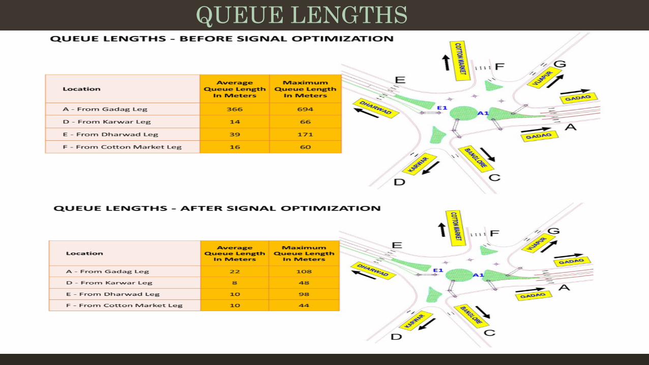
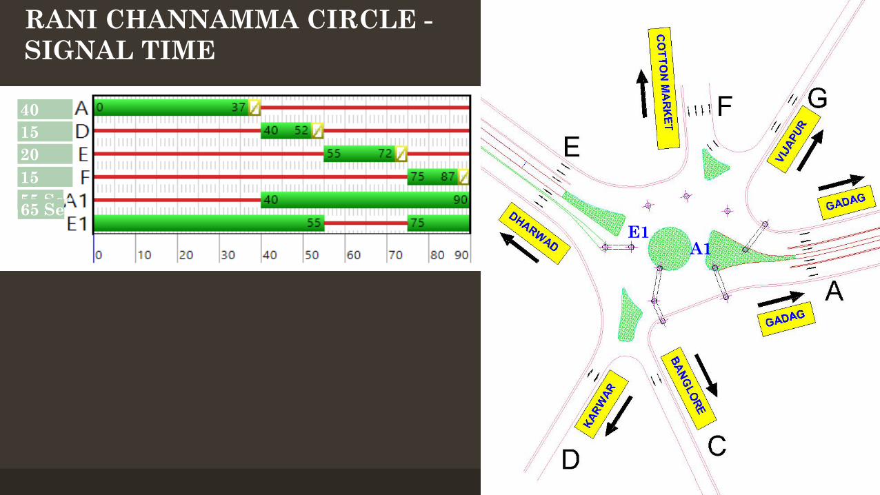
QUEUE LENGTHS
40 Sec15 Sec20 Sec15 Sec55 Sec65 Sec
A1E1
RANI CHANNAMMA CIRCLE -SIGNAL TIME
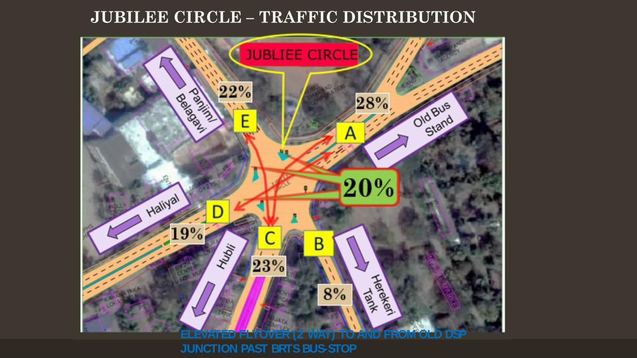
JUBILEE CIRCLE – TRAFFIC DISTRIBUTION
ELEVATED FLYOVER (2 WAY) TO AND FROM OLD DSP JUNCTION PAST BRTS BUS-STOP
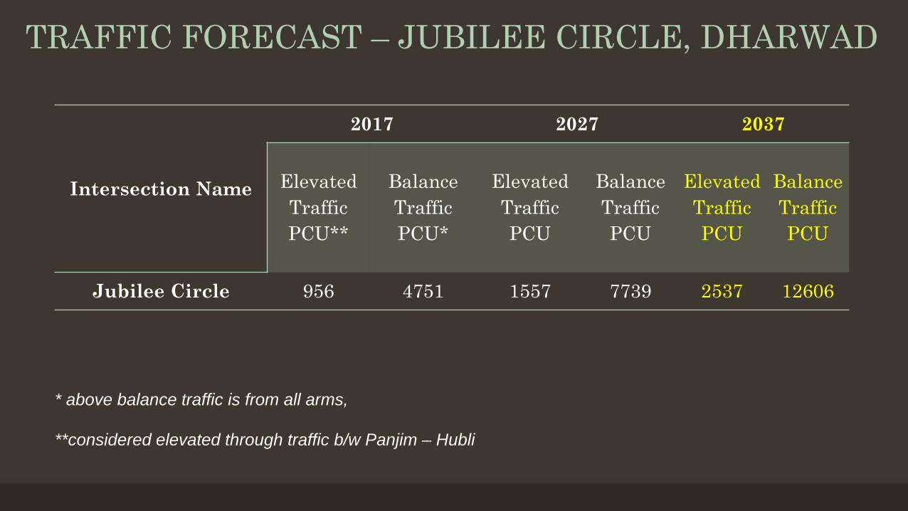
TRAFFIC FORECAST – JUBILEE CIRCLE, DHARWAD
Intersection Name
2017 2027 2037
Elevated Traffic PCU**
Balance Traffic PCU*
Elevated Traffic PCU
Balance Traffic PCU
Elevated Traffic PCU
Balance Traffic PCU
Jubilee Circle 956 4751 1557 7739 2537 12606
* above balance traffic is from all arms,
**considered elevated through traffic b/w Panjim – Hubli
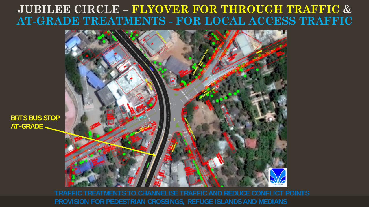
TRAFFIC TREATMENTS TO CHANNELISE TRAFFIC AND REDUCE CONFLICT POINTSPROVISION FOR PEDESTRIAN CROSSINGS, REFUGE ISLANDS AND MEDIANS
JUBILEE CIRCLE – FLYOVER FOR THROUGH TRAFFIC &AT-GRADE TREATMENTS - FOR LOCAL ACCESS TRAFFIC
BRTS BUS STOPAT-GRADE
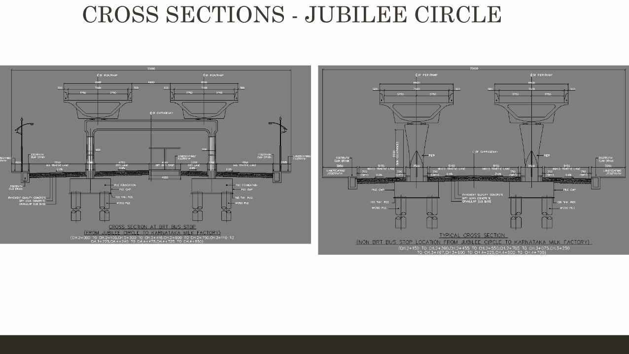
CROSS SECTIONS - JUBILEE CIRCLE
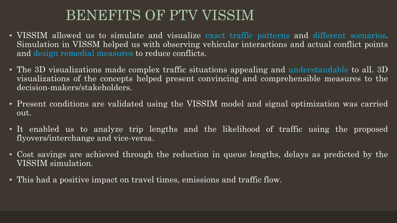
BENEFITS OF PTV VISSIM• VISSIM allowed us to simulate and visualize exact traffic patterns and different scenarios.
Simulation in VISSM helped us with observing vehicular interactions and actual conflict pointsand design remedial measures to reduce conflicts.
• The 3D visualizations made complex traffic situations appealing and understandable to all. 3Dvisualizations of the concepts helped present convincing and comprehensible measures to thedecision-makers/stakeholders.
• Present conditions are validated using the VISSIM model and signal optimization was carriedout.
• It enabled us to analyze trip lengths and the likelihood of traffic using the proposedflyovers/interchange and vice-versa.
• Cost savings are achieved through the reduction in queue lengths, delays as predicted by theVISSIM simulation.
• This had a positive impact on travel times, emissions and traffic flow.
• A rotary is an intersection where traffic flows in a circular pattern.Outer dedicated, delineated arms are provided for through trafficthat need not enter the circulatory motion.
• Rotaries allow for the movement of more traffic in less time thana normal intersection because they do not have stop signs or trafficlights.
• Rotaries can also improve the safety of an intersection as thereare no left turns in front of oncoming vehicles & also act as a trafficcalming measure since traffic moves slower through the intersection.
• Studies have shown modern rotaries to eliminate head on and highspeed collisions resulting in a 90% reduction in fatalities, 80%reduction in injuries and a 40% reduction in overall collisions.
• Requires minimal to no land acquisition at Rani ChennammaJunction. Flexibility is built into the interchange design toaccommodate possible future changes, particularly when changesto land use are likely to substantially alter traffic patterns.
Rani Chennamma Junction - Safe, Inclusive and Welcoming intersection for All
The proposed solutions separate the major crossing movements and enable maximum traffic volumes to operate uninterrupted.
By minimising conflicts, the proposed solutions offer safer and welcoming intersections that are functionally efficient & aesthetically pleasing.
For Rani Chennamma Junction flexibility for future expansion without reconstruction is provided.
Gives a visually pleasing view of the historically significant and heritage listed Rani Chennamma statue when travelling over the rotary thereby enhancing the community character and pride of the locals.
BENEFITS OF THE PROPOSED TREATMENTS/SOLUTIONS EFFICIENT OPERATION: Accommodates the warranted turning & through movements identified through the traffic analysis;
SAFE: Substantially reduces the number of conflict points between heavy through traffic and local access traffic. Improves the
safety of the at-grade intersection and interchange by grade separating heavy vehicles from pedestrians and local access traffic. Makes the at-grade intersections more welcoming and pedestrian-friendly.
Traffic calming measures are incorporated in the design concept.
STAKEHOLDER REQUIREMENTS: Considers Smart City & relevant authority requirements for pedestrian safety/movements at the at-grade level by separating heavy through traffic and a proportion of local access traffic thereby making the at-grade intersection safer.
AT-GRADE: Helps better planning and design of the at-grade traffic treatments which would cater mainly to local access traffic, pedestrians, cyclists, buses travelling to and from the nearby bus stands and BRTS.
INCLUSIVE: At the at-grade level, safely accommodates and makes allowances for multiple modes (i.e. pedestrians, cyclists, BRTS and low to medium density local access vehicular traffic) thereby making it safer and more functional and in line with Smart City requirements.
FUNCTIONAL: Improves overall traffic operations by appropriate restriction of access & enforcing consistent traffic behavior to allow the local road system and the heavy through traffic to operate effectively and efficiently. Treatments proposed are aesthetically pleasing in form & function.
CAPACITY: Reduces/eliminates capacity and congestion issues associated with vehicular parking at and in the vicinity of the at-grade intersections. For Rani Chennamma Junciton, flexibility is provided for future expansion without reconstruction.