67
Transboundary issues and IWRM Concepts By Watt Botkosal Deputy Secretary General National M-IWRMP Coordinator
| Date post: | 16-Aug-2015 |
| Category: |
Government & Nonprofit |
| Upload: | watt-botkosal |
| View: | 24 times |
| Download: | 1 times |

Transboundary issues and IWRM Concepts
By Watt Botkosal
Deputy Secretary GeneralNational M-IWRMP Coordinator

About the Mekong river Basin
• Mekong river is the main resources for more than 60 million people at the present in the Lower Mekong Basin. In fact, Water resources management and water-related development can, at the same time, support macro-economic growth and rural livelihoods.
• The Mekong flows for almost 4,800 km from its source in Tibet through 6 countries, China and Myanmar in the Upper Mekong Basin, and Lao PDR, Thailand, Cambodia and Viet Nam in the Lower Mekong Basin (LMB) into the South China Sea, draining a basin area of 795,000 km2 and with a mean annual discharge of approximately 475 km3 or 475,000 MCM.
• The Mekong is the second most bio-diverse river in the world after the Amazon, and supports the world’s largest fresh water capture fishery of about 2.3 million tons per year.

• The Mekong River, the longest river in Southeast Asia and one of the largest rivers in the World, its drainage area is 795,000 km2 ranking as twenty-first and its length is 4,800 km, in rank of twelfth, its runoff (475,000 million cubic meters) is ranked as eighth in the World.
• About 86% of Cambodia’s territory locates within the basin of the Mekong, the Bassac and the Tonle Sap Rivers and the Tonle Sap Great Lake with its tributaries
Mekong River Basin

Views of Lower Mekong Basin Countries
• The Mekong River is vital to the interests of the MRC Member States and until recently has remained in a largely unchanged state from historical times.
• However, development pressures in all countries sharing the Basin are already affecting the river’s regime and the livelihoods of those dependent upon the river’s rich bio-diversity.
4


Cambodia in the Mekong Basin
• The Mekong River extends about 500 km and at Phnom Penh Chaktomuk junction (Quatre-bras junction), the Mekong River meets the Tonle Sap River then splits into two rivers namely the lower Mekong River and the Bassac river flowing parallel the lower Mekong down into the South China Sea.
6

Mekong river system in Cambodia
• Fresh water is a critical resource to be managed and developed with appropriate manner as long term driven factor for economic and industrial activities, for agriculture and food production, water supply and goods services, including tourism and recreation.
7

About Tonle Sap
• Four main large rivers meet at the confluence (Chaktomuk junction) at Phnom
Penh namely Mekong River (Mainstream), Tonle Sap River, Lower Mekong River
and Bassac River.
• The significant Great Lake “ Boeng Tonle Sap” connects with the Mekong River is
the primary natural regulator of the region’s Mekong River flow. The largest
natural lake and most productive freshwater lake in Southeast Asia, covers
flooded forests (10,000 km2) and rice field areas that had been recognized as the
HEART OF CAMBODIA.

Tonle Sap lake
・ The largest freshwater lake in South-East Asia
・ Area: 2,500 km2 in dry season (water depth: 1-2m) 14,000 km2 in rainy season
(water depth: 9-11m)
・ Volume: 80,000 million m3
・ Catchment: 84,000 km2
・ The Tonle Sap river flows up to the lake in rainy season reversely.
・ 75 fish species are routinely found in the catch.

Tonle Sap Lake Water depth: 0.5 – 10 mArea: 2,500 – 14,000 km2 Volume: 1.3 – 80 km3
N
100 km0 50

TSL -Natural reservoir
• During dry season “normal flow” from TSL to Mekong
• During wet season reverse flow from Mekong to TSL
Flow direction• To Mekong: Oct-May• To TSL: Jun-Sep

Baseline InformationTonle Sap
Area: 1,500-15,000 km2
Vol: 1.5 -70 km3
WL: 0.6-9.6 m
Reverse flows: Late May-Late Sep (120 days)
Outflow: Late Oct-Late Dec (245days)
Strungteng
Prek Kdam
Kampong Luong
ST Dry Wet
WL(m) 2.3-2.9 5.2-7.4
Vol (km3) 45-80 253-468
PKD Outflow Reverse
WL(m) 9.6-0.6 1.0-9.6
Vol (km3) 54-87 18-51
57%
30%
13%
Mekong
Tributary
RainfallFlow in wet season

Tonle Sap Water Balance in yearly average (unit in km3)
Source: MRC-WUP-FIN, 2003

Significance of Tonle Sap Basin system
• Over 86% of Cambodia lies within the Mekong basin,
• The Tonle Sap is an environmental area of global significance, undoubtedly of critical importance to Cambodia, in terms of both current benefits and resources available for future development.
• These include:• Fisheries resources for food security and a social safety net.• Large potential water resources for expanding irrigated agriculture.• Navigation, domestic water transport and eco-tourism.• Potential for hydropower development.• Flood management and control.• Ecosystem protection and conservation

Flooded forest

Mangrove Forest
Floating Houses

Changing Issues
• Decrease of the reverse flow resulting in reduced flooded areas, depth and duration (Definite Future Scenario)
• Reduction of inflow of nutrients with the sediments; loss of nutrients entering the system will be compensated to some extent by return flows from irrigation areas around the Lake (20-Year Plan Scenario)
• Severe reduction in biodiversity and capture fisheries yield in the 20-Year Plan Scenario (-57% in Cambodia and 25% in the Mekong Basin compared to the Baseline Scenario
• Up to 2,000,000 vulnerable resource users could be affected in Cambodia (20-Year Plan Scenario)

Observed data at Prek Dam between July 1960 and June 1973
Sense of variability

Inflow into Tonle Sap (June - September)
Outflow from Tonle Sap (October - May)
Inflow and outflow from Tonle Sap
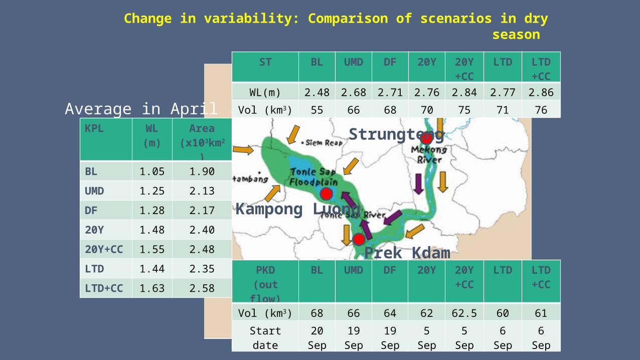
Change in variability: Comparison of scenarios in dry season
Strungteng
Prek Kdam
Kampong Luong
ST BL UMD DF 20Y 20Y+CC
LTD LTD+CC
WL(m) 2.48 2.68 2.71 2.76 2.84 2.77 2.86
Vol (km3) 55 66 68 70 75 71 76
PKD(out flow)
BL UMD DF 20Y 20Y+CC
LTD LTD+CC
Vol (km3) 68 66 64 62 62.5 60 61
Start date 20Sep
19Sep
19Sep
5Sep
5Sep
6Sep
6Sep
KPL WL(m)
Area(x103km2)
BL 1.05 1.90
UMD 1.25 2.13
DF 1.28 2.17
20Y 1.48 2.40
20Y+CC 1.55 2.48
LTD 1.44 2.35
LTD+CC 1.63 2.58
Average in April

Change in variability: Comparison of scenarios in wet season
Strungteng
Prek Kdam
Kampong Luong
ST BL UMD DF 20Y 20Y+CC
LTD LTD+CC
WL(m) 6.10 5.99 5.95 5.79 5.90 5.71 5.92
Vol (km3) 338 327 323 308 314 301 321
PKD(Reverse flow)
BL UMD DF 20Y 20Y+CC
LTD LTD+CC
Vol (km3) 32.2 30.1 29.7 28 29.5 26.9 31
Start date 24 May
21May
21May
16May
19May
12May
22May
Average in OctKPL WL
(m)Area
(x103km2)
BL 8.02 11.4
UMD 7.88 11.2
DF 7.81 11.1
20Y 7.64 10.8
20Y+CC 7.84 11.1
LTD 7.51 10.6
LTD+CC 7.73 11.0

Experiences with trans-boundary
water cooperationMekong River Basin in general and particular case of Sekong-Sesan-
Srepok River basin

Critical zones of 3S rivers, Tonle Sap & Mekong
23
Stung Treng to Kratie
Kratie to Phnom Penh
Tonle Sapsystem
Phnom Penh to the sea – Mekong Delta
Sekong
Sesan
Sre Pok
24
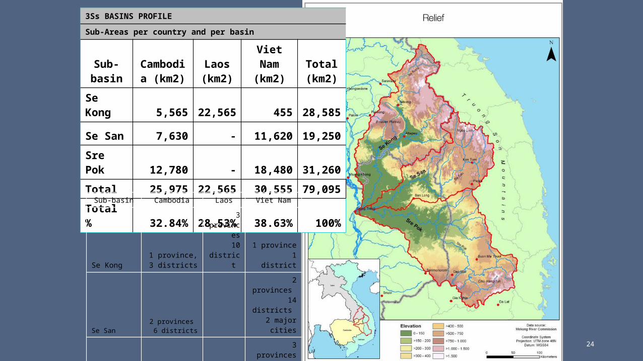
3Ss BASINS PROFILE
Sub-Areas per country and per basin
Sub-basin
Cambodia (km2)
Laos (km2)
Viet Nam
(km2)Total (km2)
Se Kong 5,565
22,565 455
28,585
Se San 7,630 - 11,62019,25
0
Sre Pok 12,780 - 18,480
31,260
Total 25,97522,56
5 30,55579,09
5
Total % 32.84%
28.53% 38.63% 100%
Sub-basin Cambodia Laos Viet Nam
Se Kong1 province,
3 districts
3 provinces
10 district 1 province
1 district
Se San2 provinces
6 districts
2 provinces 14 districts
2 major cities
Sre Pok3 provinces10 districts
3 provinces21 districts
1 major city

25
Location: Northeastern Cambodia
Total area: 26,521 km2
Provinces covered: -Stung Treng (61.75%)- Ratanakiri (100%)- Mondulkiri (48.88.%)
No. of main secondary tributaries: 25
-On Se Kong: 5-On Se San: 8
- On Sre Pok: 12
Rainfall: 1,600mm-2,400mm
Sub-Area 7C

About Cambodia Mekong Delta

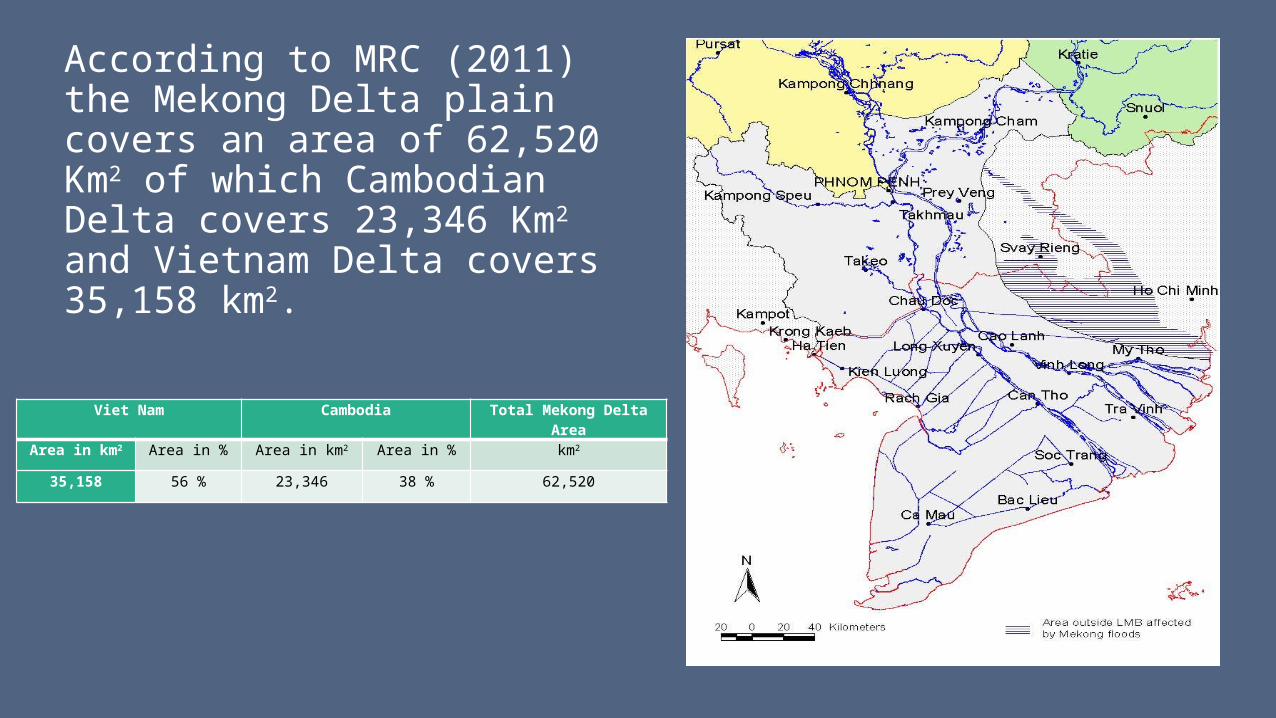
According to MRC (2011) the Mekong Delta plain covers an area of 62,520 Km2 of which Cambodian Delta covers 23,346 Km2 and Vietnam Delta covers 35,158 km2.
Viet Nam Cambodia Total Mekong Delta Area
Area in km2 Area in % Area in km2 Area in % km2
35,158 56 % 23,346 38 % 62,520

MRC Started with transboundary cooperation • Since 2000, MRC’s Basin Development Plan Programme and other
programmes and projects have prepared river basin profiles, organized trans-boundary meetings, and conducted studies that have increased the knowledge base of the critical issues at stake in the 3S Basins.
• The Asian Development Bank and World Bank (ADB/WB) Mekong Water Resources Assistance Strategy (2006) identified the need for strategic collaboration in the 3S Basins
• The MRC Mekong IWRM Project, launched in 2012, included interlinked regional, trans-boundary and national components.
• Mekong Delta-Cambodia and Vietnam• Se San and Sre Pok-Cambodia and Vietnam• Mekong and Sekong-Cambodia and Laos

Mekong Delta and Se San and Srepok TB ProjectsObjectives:• (i) Transboundary Significant Water Management Issues between
Cambodia and Viet Nam is identified.• (ii) An effective transboundary data and information processing
and sharing mechanism between Cambodia and Viet Nam is established
• (iii) An effective IWRM-based transboundary dialogue between Cambodia and Viet Nam for a future transboundary river basin monitoring plan in the Mekong Delta and 2S are established.

Transboundary issues
• Uncoordinated river basin use and management• Pressure on the resources: river, ground water, forests, fish • Trans-boundary impacts of hydropower development
• River flow • Water quality • Sedimentation• Flood • Fisheries and other aquatic resources of the river and its system are under pressure
• Need for meaningful and effective cooperation
31

Main delta-issues
• Low water related investment toward economic development in Cambodia Mekong Delta
• Joint future development and management of water resources in transboundary Mekong Delta between Cambodia and Vietnam, strong basis for further interventions in the cross-border sites
• Flood and drought management (lack of mechanism and facility to control and manage flood and drought hazards.
• Navigation interests • in inland water transport around the Tonle Sap and the delta, as well as in the access to the
sea through the Mekong and Bassac rivers
• Technical and financial capabilities • Financial capabilities to support poverty reduction for creating economic advantages for low-
income families (farmers) and unemployment • Technical capacity to support for water resources management for increasing better health,
wealth and environment

Main issues
● Development activities have pressure on the resources (river, ground water, forests, fish resource), large part of most productive land still depends on natural conditions- extreme and frequent flooding and frequent drought which are major problems;
● Frequent local seasonal scarcity of water; ● Change of river morphology in the Mekong mainstream due to
bank erosion; ● Change in land use leading to loss of wetlands and placing
threats on the aquatic ecosystems;● Urbanization, which is fast and significant in scale;● Climate change impacts to water resources.
33

Levels of trans-boundary water cooperation• It should be recognized that countries that share a river basin will always have a national
agenda. They will cooperate if it serves that national agenda.• Increased trans-boundary cooperation does not always create more benefits to the basin
countries. The optimal type of trans-boundary cooperation will vary depending on hydrologic and environmental conditions, the investment opportunities, and other factors that determine the potential benefit sharing mechanisms in a river basin. In some basins, simple information sharing may be all that is needed to facilitate optimal trans-boundary cooperation. In other basins, joint actions on river regulation, water storage and drought and flood mitigation would yield significant net benefits. In yet other basins, joint ownership and management of infrastructure would increase basin-wide benefits and reduce trans-boundary costs.
• A major challenge is to identify the right type of cooperative effort--one in which the benefits of cooperation outweigh the costs, and where the process and outcome is politically and socially acceptable. In a particular basin, the appropriate level of cooperation can be explored through a Cooperative Regional Assessment (CRA) .

Cooperative Regional Assessment (CRA)
• CRA is a technique that has been designed as a flexible and powerful instrument to bring riparian countries together to identify the full range of options and choices that are available to optimise and share the benefits of cooperation.
• The benefits identified by CRAs could then motivate countries to continue or intensify their cooperative efforts to capture those benefits.
• The CRA process is underpinned by three elements: institutional strengthening, process design and trans-boundary assessment.

CRA elements: institutional strengthening, process design and trans-boundary assessment.
• Trans-boundary cooperative assessment of the distribution of benefits, impacts and risks of existing and planned development in a basin, as well as of alternative development scenarios, including joint projects and national projects of trans-boundary significance, and taking account of the wider Mekong region context;
• Distribution analysis of costs and benefits that will accrue across countries and sectors under existing and alternative development scenarios, taking into account the wider context of the Mekong region;
• An institutional analysis of the possible levels and modes of cooperation necessary to capture the greatest net benefits, taking account of the costs of cooperation within the wider context of the Mekong region.

IWRM concepts

IWRM Process and Concepts
• BDP has been fully applying IWRM concepts by considering the integrated planning of land and water resources management at Mekong river basin, sub-basin, sub-areas and catchment areas in countries.
• 10 Sub-areas are divided and used for planning and management purposes characterized by upstream-downstream dynamics, watersheds (hydrological) and administrative boundaries designed.

Key Development Issues
Agriculture Fisheries/Aquaculture Irrigation, Flood Control and Hydropower Watershed Management Tourism Water Supply, Waste Management and Sanitation Navigation and Transportation Private Sector/Markets Capacity Building Participation Institutional and Legal Issues

IWRM-based BDP process

IWRM-based BDP processAchieving three key strategic objectives:
• Efficiency, since, given scarcity of resources (natural, financial and human), it is important to attempt to maximise the economic and social welfare derived not only from the water resources base but also from investments in water services provision.
• Equity in the allocation of scarce water resources and services across different economic and social groups is vital to reduce conflict and promote socially sustainable development.
• Sustainability, as ultimately all attempts at water management reform will fail if the water resources base and associated ecosystems continue to be regarded as infinitely robust and we continue to put at risk “the water system that we depend on for our survival”
41

Lessons learns• 1995 MA - A Shared River Basin Vision
• MRC established strong riparian ownership
• Continuing effective lead donor/partner
• Full partnership and commitment of donors/partners (funds, technical and facilitation)
• IWRM-based BDP -Basin planning priorities and actions based on the national priority and situation
• IWRM-based basin development strategy was developed based on trust
• Strong advocacy and stakeholder stakeholders participation: different level and multi-stakeholders

Lessons learns
• Sharing benefits, win-win objective/strategy. Approach to create incentives for the process and demonstrate benefits within BDP formulation and implementation process
• Adequate funding for BDP and promote investments for the process is critical importance
• BDP can promote transparency and accountability of riparian countries
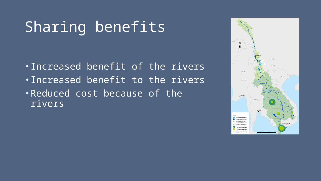
Sharing benefits
• Increased benefit of the rivers• Increased benefit to the rivers• Reduced cost because of the rivers

Increased benefit of the rivers
• Main issues: sustainable water resources development
• Needs: Improved water related development and planning including outcomes of hydropower and agricultural production, integrated flood and drought management, environmental conservation and water quality.

Increased benefit to the rivers
• Main issues: Because of limited water resource management or mismanagement: degraded sediment, fisheries catch, watersheds, wetlands, biodiversity, and change in water flow and water quality, climate change impact.
• Needs: Improved water quality, river flow characteristics (through monitoring and assessment), watershed management, soil conservation, biodiversity

Reduced cost because of the rivers
• Main issues: Tense positive/negative regional relations and political economy impacts such as mainstream development
• Needs: Policy shift to cooperation and development, from dispute; from food and energy self-sufficiency to water security; reduced conflict risk etc..

48
Mekong development: meeting the needs, keeping the balance
‘Complex hydrology’ and limited investments in water management and infrastructure often correlates with widespread poverty around the world
Unique biodiversity and large fisheries on which millions of people in Mekong Basin depend
Much of the Mekong Basin remains among the poorest regions - malnutrition poses great challenges
Increasing demand for water resources development to reduce poverty and support an increasing population
Storage

BDP delivered the plan up to 2011
Had to move beyond process: by 2007 water resources development was accelerating
Conducted a basin-wide cumulative impact assessment of the basin countries’ national plans, with and without consideration of climate change impacts (reported in 14 volumes)
The assessment demonstrated the considerable interplay between water, energy, food, environmental and climate security
With coordinated national planning, benefits can be created for all countries.
A few examples are given in the next slides

Example 1: Synergy between hydropower and irrigation development plans (20-year plan scenario)
50
Risk is small during the next 20 years that the redistributed water from the wet to the dry season by hydropower development is not sufficient to source the irrigation developments that are being planned
Transboundary benefit sharing in these two sectors amounts to $7,000 million
The natural dry season flow regime can be protected
Key assumptions
UMB dams in place by 2015 100% LMB dams found viable 100% Proportion of Thai irrigation from diversions/lift 95%
UMB dams in place by 2020 100% UMB dam performance 100% Proportion of Lao irrigation dependent upon dams 35%
Water balance at Tang Chau for average monthly flow in March, MCMCompared to baseline, shows incremental flow augmentation from UMB and LMB dams against incremental abstractions for irrigation and water supply
0
1,000
2,000
3,000
4,000
5,000
6,000
7,000
8,000
2000 2005 2010 2015 2020 2025 2030 2035 2040 2045 2050 2055 2060
LMB dams
China dams
Viet Nam irrig.
Cambodia irrig.
Lao irrigation
Thai irrigation
Water supply
2060 set at Very High Development
2060
2010
2030
2030

Example 2: Trade-off between hydropower development plans and capture fisheries Yield will either increase or
decrease in rain-fed areas which depend on management practice while in reservoirs, yield will increase
Reduction will mainly happen in river-floodplain habitat due to many factors i.e. barriers, flow changes, habitat loss
The lower of the proposed eleven mainstream dams have the largest impact on LMB’s capture fisheries.
Regional capture fisheries net cost due to hydropower development amounts to $1,700 million in the 20-year plan scenario
ThailandCambodia
Viet Nam Delta
Lao PDRViet Nam Highland

Example 3: Impacts of climate change
52
In the 20-year and long-term scenarios, climate change reverses the reduction of flooding caused by ongoing and planned development
Climate change would benefit environmental values (by $240 million), increase recession rice production (by $450 million) but all of this will be offset by increased flood damages (by $650 million)

Basin Development Strategy
53
Based on the assessment results of the basin-wide scenarios and the SEA of the proposed LMB mainstream dams, and the associated stakeholder consultations
For the first time since the 1995 Mekong Agreement, the countries have arrived at: An understanding of each other’s water-related plans
discussed the likely transboundary impacts of their plans
Developed a shared understanding of the water-related development opportunities and risks
Negotiated the Basin Development Strategy

The Strategy describes
• Development opportunities to improve water, food and energy security
• 15 Strategic Priorities
For Basin Development For Basin Management
To: Address knowledge gaps and move identified
development opportunities to implementation Broaden and strengthen the basin planning
framework
• A Roadmap for implementation 54
• How the MRC member countries will share, utlize, manage and conserve the water and related resources of the Mekong to achieve the goals of the 1995 Mekong Agreement

Implementation of the Strategy is underway at the regional and national level and will:
• Reduce knowledge gaps (fisheries, sediments, ecosystems)
• Address the adverse impacts of ongoing development
• Develop a Mekong multi-sector mechanism for transboundary cost and benefit sharing
• Develop environmental and socio-economic baselines
• Bring regional and national planning ‘closer together’
• Broaden the current basin-wide scenarios to assess how regional benefits can be increased and regional costs reduced
• Strengthen regional cooperation on basin planning and the implementation of the MRC Procedures

The future of the BDP
Responsible Growth

57
The BDP
The BDP will act as the instrument for impact analysis and consultation
Much of future basin development can and should be undertaken at the national level
The BDP will explore ways to achieve transboundary benefits and mitigate transboundary costs, through the adaptation and modification of national investments.
There are almost certainly transboundary opportunities, where two or more LMB countries could develop joint projects that provide substantive benefits that can be shared.
The only mandated instrument for identifying and promoting such opportunities is the BDP

Key Challenges
• Timely and efficient implementation of MRC MA and Procedures
• Sustained long term donor support to BDP
• Broadening participation at the basin, sub-basin country and transboundary levels - through projects and multiplier effect, and other activities
• Minimized conflicts in the region affecting effective participation of countries and timely implementation of projects
• Available fund for MRC BAC and National NIP implementation. • Appropriate projects for seeking funds. Strong linkages BAC and NIP and other national and regional initiatives
and programs.
• BDP be applied to support decentralization process such implement the NIP, need to be adequate financial resources, strong local capacity in terms of knowledge base, data and information and with appropriate water resources management and governance frameworks.

Summing-up
59

Conclusion
• The 1995 Mekong Agreement is about cooperation on balancing basin development and protection trough basin development framework.
• The BDP is a primary instrument for this cooperation created the sustainable development for the Basin
• The BDP will explore ways to achieve transboundary benefits and mitigate transboundary costs, through the adaptation and modification of national investments which contribute to the water resources and basin management and development based on sustainable development perspectives
• The implementation of MRC Basin Development Strategy shall support the green economy strategies or the supplementary to the national or regional green economy development strategies.
60

Conclusion (cnt.) • Cambodia has over 85% of population live in rural area and about 75% are farmers and
fishers whose livelihood depends on agriculture. Most of them are poor;
• Rural people directly use natural resources as their primary source for daily subsistence;
• Cambodia has dominant rivers, but the utilization of water is still limited, while irrigation system is less developed and poor-developed hydropower schemes;
• Agriculture cultivation mostly depends on natural conditions: rainfall water;
• Community-based sectors were performed, but some are not well functioned due to limited capacity and lack of fund and good facilities. It might be lack capacity to understand the government policy/Law/Regulation, high rate of illiteracy of rural people, no skills, low knowledge or limited facilities and the poverty problem;

Conclusion (cnt.)
• Communities are established to support the government in implementation of national policy and programs
• Communities have opportunities to access and control of natural resources within their areas with their own proposed projects if they have adequate capacity to manage by themselves.
• Decentralization policy of the Government took place since March 2002, is a very new concept for Cambodia to delegate local authority also to promote community-based sectors participation.
• Occasionally, communities’ interest conflicts happened, the resolution made through national agency/Government or court;
• MRC, CNMC in cooperation with line agencies as a main sponsor of technical assistance and funding for projects, had played good roles in sectors’ activities with local communities/provincial officers to assess water and related resources.

Conclusion (cnt.) • BDP is an Integrated Water Resources Management and Development Plan.• BDP is transboundary plan that involved by four different riparian countries• Maintaining the BDP planning process• More interfaces with others programmes and mechanisms to be considered
as important integrated data and knowledge inputs for BDP outcomes• Existing Sub-Area studise, analysis and development are important resource
of document for development of Sub-area and Basin-wide management strategies, which will contribute ultimately to the development for the LMB.

Conclusion (cnt.) • Experiences and lessons learned from BDP and its outcomes, the basin development model are
recognized by riparian for continuing next BDP process
• A number of challenges for the MRC and BDP could be overcame and create more opportunities that enormous and encouraging.
• Know-how the way BDP to support and promote more effective collaborative water resources management that the only way for utilizing this opportunity for better cooperation among the riparian countries.
• MRC and BDP create the benefit sharing to shared river and from shared river, realizing the socio-economic development and environmental protection for the whole common water resources in the Mekong Basin.
• MRC Strategic Plan and Action Plan (Regional Action Plan) and Basin Action Plan are complementary programs to support riparian government trough NIPs.
• The implementation of RAP, BAC and NIPS will focus on the confidence of collaborative building and stakeholders’ involvement in the whole cycle planning.

Recommendations
• Communities must be joined hand together to protect, maintain, develop and manage the natural resources with clear-cut goal, objective of integrated water management perspectives,
• Capacity building, Training and awareness are needed for community members in terms of environment aspects, River assets, river basin management and capacity to participate in planning and implementation process and set up an approach for national policy, development objectives and strategy implementation;
• Communities must be strongly supported by the Government and other international agencies,
• MRC must be promoted and extended its mandate into more community-based sectors, while CNMC has to be more creative and proactive as well as capable to work with those communities esp. to be strong on skills for conflict management. BDP is one approach to promote and enhance the involvement of communities, however, this must be with more comprehensive and deeply consulted process.
• Cambodia-Thailand Cooperation Outreach Project on Tonele Sap and Songkla Lake is very much significant for both countries

Way Forward• Continue addressing the issues of concern institutional and challenges of MRC and
BDP. Implementation challenges at regional, national and sub-national levels through collaborative water management programs and coordination projects or activities.
• Strengthening trust and ownership for riparian leadership and broadening and qualified participation of multi-stakeholders,
• Short and long term commitment and will from policies makers and all technical aspects to process and product and partnerships
• Long-term collaborative water management and cooperative framework need to be established. Thought BDP:
• Strategy for building collaborative water resources management and planning • Promotion of stronger public awareness and understanding of the BDP process• Develops confidence in regional and cooperation under the BDP • Ensures full key stakeholder involvement in the BDP and its implementation process with sufficient funds

For discussion
•What you meant for transboundary issues for Tonle Sap Basin?
•What do you think that IWRM concept could address that issues?


