ew-dg-2012_tis- dg03_05_travelconditionandtraveltimeinformation_02-00- 00.docx 01/01/2012 1/56 Traveller Information Services TRAFFIC CONDITION AND TRAVEL TIME INFORMATION Deployment Guideline TIS-DG03-05 | VERSION 02-00-00 | DECEMBER 2012
Preamble EasyWay is a cooperation of road authorities and road operators from 27 European countries that have teamed up to unlock the benefits of cooperation and harmonisation in the deployment of Intelligent Transport Systems (ITS) on Europe’s major road network. ITS as a technology is a known contributor to sustainable mobility in terms of improved safety, efficiency and reduced environmental impact. Nevertheless, fragmented deployment on a national level will fail to deliver seamless European services and will not contribute to a coherent European Transport network. The European Member States have consequently launched the EasyWay project together with the European Commission as a platform to harmonise their ITS deployments.
This document has been drafted by EasyWay as part of the set of documents containing the 2012 version of the EasyWay Deployment Guidelines (DG 2012). These guidelines have been developed by EasyWay experts and practitioners. They have undergone a thorough review by international domain experts in an intense peer review exercise and they have been validated by the participating Member State Partners of EasyWay in an extensive formal Member State consultation process, which finally led to their adoption as basis for all deployment activities in future EasyWay phases.
EasyWay as a project is not a standardisation body, nor does it have any power to legally constrain the Member State in their national deployment activities. It is therefore crucial to understand that these documents are neither technical standards, nor are they specifications as they would be required for such cases, e.g. as currently developed by the European Commission as their part of the implementation of the ITS Directive 2010/40/EU. But since a certain level of strictness in compliance is required to achieve the intended goal of the EasyWay Deployment Guidelines – harmonisation and interoperability in Europe – the guideline documents are written in a way that clearly defines criteria that deployments have to fulfil in order to claim overall compliance with the guideline.
Although not legally binding in any sense, compliance may be required for the eligibility of deployments in future ITS road projects co-funded by the European Commission. Deviation from compliance requirements may nevertheless be unavoidable in some cases and well justified. It is therefore expected that compliance statements may contain an explanation that justifies deviation in such cases. This is known as the “comply or explain” principle.
Although not standards themselves, the EasyWay DG2012 Deployment Guidelines in some cases do mention – and sometimes require – the use of such standards. This is the case in particular regarding the use of the CEN/TS 16157 series of technical specifications for data exchange (“DATEX II”). Although standardised data exchange interfaces are a powerful tool towards harmonised services in Europe, it must be understood that real world deployments have to fit into existing – and sometimes extensive – infrastructures and investment in these infrastructures must be protected. It is therefore important to note that the use of DATEX II mentioned below as a MUST is referred to implementation of “new” data exchange systems and not the utilisation of the existing ones, unless these latter affect harmonisation of deployments or interoperability of services.
"Traffic condition and travel time information service” means, both pre-trip and on-trip, the provision of traffic condition (LoS) and travel time information on identified road segments of the TEN-T network and interfaces, thus enabling road users to optimize and better anticipate their journey ahead. This predictive or real-time information will use different information channels, accessible by the road user via different end-user devices. The service may comprise common as well as individual (personalised, on-demand) information.
SERVICE OBJECTIVE
The intention of the service is to make road users react and adapt their driving behaviour to the traffic conditions they are going to meet, by informing them about the current and the expected development of traffic conditions and travel times. The vision is that a user provided with high quality information will react and adapt his travelling and driving behaviour to include a change of routes, modes or trip schedule (time of departure) as well as changes in the way of driving. Thus the road traffic network is used in a more efficient and safer way with significant contributions to improving environmental performance, energy efficiency, and security of road transport.
SERVICE BENEFIT RADAR
EUROPEAN DIMENSION
Ideally traffic condition and travel time information should at the European dimension provide continuity across neighbouring regions and between member states. Thus the purpose of this Deployment Guideline is to develop the existing services towards a truly European (pan-European) service and to assure an adequate service quality (Level of service). The European continuity aspects are:
• the service coverage (geographical and time availability),
• the continuity as regards content across corridors and TEN-T network and interfaces,
• the language-independence characteristics and
• the provision of information about the existence and the price of use of the services and how to access.
Provision of information by means of pictograms or colours on a digital map tends to be language independent, but the pictograms and colours are not uniform across Europe at present. Complementary information (spoken or text) requires translation and provision in different languages.
4
ESG1 – EUROPE-WIDE TRAVELER INFORMATION CONTINUITY & CO-MODALITY
TIS-DG03-05 – TRAFFIC CONDITION AND TRAVEL TIME INFORMATION
1.2.2 Contribution to EasyWay Objectives ............................................................................................... 13
1.2.3 Current status of deployment ......................................................................................................... 14
1.2.4 European Dimension ....................................................................................................................... 17
2 Part A: Harmonization Requirements .................................................................................................. 18
2.1 Service Definition ................................................................................................................................. 18
2.6.2 Level of Service Criteria ................................................................................................................... 33
2.6.3 Level of Service Criteria related to Operating Environment ........................................................... 35
3 Part B: Supplementary Information ..................................................................................................... 37
3.1 Examples of deployment ..................................................................................................................... 37
3.1.1 Roadside guidance systems ............................................................................................................. 37
3.1.2 Internet portals ............................................................................................................................... 40
3.1.3 Navigation systems ......................................................................................................................... 41
3.1.4 Mobile devices ................................................................................................................................ 41
3.1.6 Radio ............................................................................................................................................... 42
3.1.8 Television ........................................................................................................................................ 44
3.1.9 Audiotex in France .......................................................................................................................... 44
3.1.10 The Traffic Scotland Web Service .................................................................................................... 45
3.2 Business Model .................................................................................................................................... 47
List of figures and tables Figure 1: Service radar “Traffic condition and travel time information” ............................................................... 13
Figure 2: Traffic Condition and Travel Time Information Service - Data and information flow ............................. 14
Figure 3: Functional architecture of the service and decomposition in three sub-functions ................................ 18
Figure 4: traffic condition and travel time information service – organisational architecture (historical) ............ 21
Figure 5: Organisational architecture – road operator point of view .................................................................... 21
Figure 6: Organisational architecture – others (not road operator) point of view ................................................ 22
Figure 7:VMS on the A10 near Madrid in Spain ..................................................................................................... 37
Figure 8: VMS on the A3 near Frankfurt am Main in Hessen (Germany) ............................................................... 38
Figure 9: VMS on the ring road of Munich (Germany, see also www.mobinet.de). .............................................. 38
Figure 10: VMS displaying travel times for both travel options (car or public transport) near Amsterdam. ........ 39
Figure 11: VMS displaying the traffic situation in a graphical way (in this case the situation at the Rotterdam Ring Road). ............................................................................................................................................................. 39
Figure 12: Website "bayerninfo.de": predictive and real-time traffic situation in Bavaria, with integrated road works- and weather information ........................................................................................................................... 40
Figure 13: Website "www.trafficengland.com" of the Highways Agency .............................................................. 40
Figure 14: Website "www.autobahn.nrw.de" of the road authority of North Rhine-Westphalia ......................... 41
Figure 15: Spanish eTraffic service: Traffic condition and travel time ................................................................... 41
Figure 16: Mobile device with traffic condition information service ..................................................................... 42
Figure 17: Traffic radio in France ........................................................................................................................... 43
Figure 18: Traffic radio in Dublin, Ireland .............................................................................................................. 43
Figure 19: Traffic radio in England operated by the Highways Agency .................................................................. 43
Figure 20: Traffic information via videotext of the German broadcaster WDR ..................................................... 43
Figure 21: Traffic Information via television on France 2 ...................................................................................... 44
Figure 22: Logo of the website and phone service Bison Futé ............................................................................... 44
Table 1: Part A - requirement wording .................................................................................................................. 10
Table 2: Characteristics of the different end-user devices (n=no, y=yes) .............................................................. 17
Table 3: Level of Service ......................................................................................................................................... 33
Table 4: Levels of Quality table .............................................................................................................................. 34
Table 5: Level of Service to Operating Environment mapping table ...................................................................... 35
Table 6: Legend - EasyWay Operating Environments for Core European ITS Services. ......................................... 36
Table 7: Traffic Scotland Web Service .................................................................................................................... 45
Table 8: Real Time Event Details ............................................................................................................................ 45
Table 9: Level Of Service ........................................................................................................................................ 46
Table 10: Icons used ............................................................................................................................................... 46
7
ESG1 – EUROPE-WIDE TRAVELER INFORMATION CONTINUITY & CO-MODALITY
TIS-DG03-05 – TRAFFIC CONDITION AND TRAVEL TIME INFORMATION
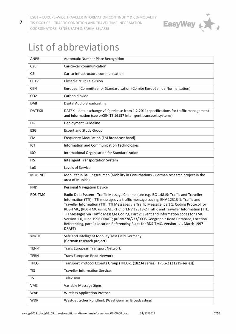
List of abbreviations ANPR Automatic Number Plate Recognition
C2C Car-to-car communication
C2I Car-to-infrastructure communication
CCTV Closed-circuit Television
CEN European Committee for Standardisation (Comité Européen de Normalisation)
CO2 Carbon dioxide
DAB Digital Audio Broadcasting
DATEXII DATEX II data exchange v2.0, release from 1.2.2011; specifications for traffic management and information (see prCEN TS 16157 Intelligent transport systems)
DG Deployment Guideline
ESG Expert and Study Group
FM Frequency Modulation (FM broadcast band)
ICT Information and Communication Technologies
ISO International Organisation for Standardization
ITS Intelligent Transportation System
LoS Levels of Service
MOBINET Mobilität in Ballungsräumen (Mobility in Conurbations - German research project in the area of Munich)
PND Personal Navigation Device
RDS-TMC Radio Data System - Traffic Message Channel (see e.g. ISO 14819: Traffic and Traveller Information (TTI) - TTI messages via traffic message coding; ENV 12313-1: Traffic and Traveller Information (TTI), TTI Messages via Traffic Message, part 1: Coding Protocol for RDS-TMC, (RDS-TMC using ALERT C; prENV 12313-2 Traffic and Traveller Information (TTI), TTI Messages via Traffic Message Coding, Part 2: Event and Information codes for TMC Version 1.0, June 1996 DRAFT; prENV278/7/3/0005 Geographic Road Database, Location Referencing, part 1: Location Referencing Rules for RDS-TMC, Version 1.1, March 1997 DRAFT)
simTD Safe and Intelligent Mobility Test Field Germany (German research project)
TEN-T Trans European Transport Network
TERN Trans European Road Network
TPEG Transport Protocol Experts Group (TPEG-1 (18234 series); TPEG-2 (21219-series))
TIS Traveller Information Services
TV Television
VMS Variable Message Signs
WAP Wireless Application Protocol
WDR Westdeutscher Rundfunk (West German Broadcasting)
8
ESG1 – EUROPE-WIDE TRAVELER INFORMATION CONTINUITY & CO-MODALITY
TIS-DG03-05 – TRAFFIC CONDITION AND TRAVEL TIME INFORMATION
1 Introduction 1.1 The concept of the EasyWay Deployment Guidelines
1.1.1 Preliminary note
This document is one of a set of documents for the EasyWay project, a project for Europe-wide ITS deployment on main TERN corridors undertaken by national road authorities and operators with associated partners including the automotive industry, telecom operators and public transport stakeholders. It sets clear targets, identifies the set of necessary European ITS services to deploy (Traveller Information, Traffic Management and Freight and Logistic Services) and is an efficient platform that allows the European mobility stakeholders to achieve a coordinated and combined deployment of these pan-European services.
EasyWay started in 2007 and has since established a huge body of knowledge and a consensus for the harmonised deployment of these ITS services. This knowledge has been captured in documents providing guidance on service deployment - the EasyWay Deployment Guidelines.
The first iteration of the Deployment Guidelines mainly captured best practice. This strongly supported service deployment within EasyWay by:
• making EasyWay partners in deployment aware of experiences made in other European deployment programmes.
• helping to avoid making errors others had already made
• reducing risk and facilitating efficient deployment by highlighting important and critical issues to consider
Meanwhile, this best practice has already successfully contributed to ITS deployments across Europe. It is now possible to take the logical next step and actually start recommending those elements of service deployment that have proven their contribution to both the success of the local deployment, as well as the European added value of harmonised deployment for seamless and interoperable services.
1.1.2 Applying Deployment Guidelines – the “comply or explain” principle
The step from descriptive best practice towards clear recommendations is reflected in the document structure used for this generation of the Deployment Guidelines. Apart from introduction and the annexes that cover specific additional material, the Deployment Guidelines consist of two main sections:
Part A – this part covers the recommendations and requirements that are proven to contribute to successful deployment and have been agreed by the EasyWay partners as elements that should be part of all deployments of this particular service within the scope of EasyWay. Thus, the content of this section is prescriptive by nature. EasyWay partners are expected to ensure that their deployments are compliant with the specifications in this section. Wherever concrete circumstances in a project do not allow these recommendations to be followed fully, EasyWay partners are expected to provide a substantial explanation for the need for this deviation. This concept is known as the “comply or explain” principle.
Part B – this part offers an opportunity to provide more valuable but less prescriptive information. Supplementary information may be contained including – but not limited to – regional/national examples of deployment and business model aspects like stakeholder involvement or cost/benefit analysis results.
1.1.3 Use of Language in Part A
It is essential for every prescriptive document to provide specifications in a well-defined and unambiguous language. There are various definitions that clarify the use of particular words (such as those listed below) within their prescriptive texts.
For the purpose of the EasyWay Deployment Guidelines, the well-established provisions of the RFC 2119 (http://www.ietf.org/rfc/rfc2119.txt, see (1)) are used, which is used to specify the basic Internet standards:
The key words "MUST", "MUST NOT", "REQUIRED", "SHALL", "SHALL NOT", "SHOULD", "SHOULD NOT", "RECOMMENDED", "MAY", and "OPTIONAL" in this document are to be interpreted as described in RFC 2119.
An overview of the keywords, their meaning and the possible answers in the context of part A provides the following table. In general the keywords in brackets are possible, but their use is not recommended in order to avoid confusion which may arise as a consequence of different common linguistic usage of the terms in the different EU member states.
Table 1: Part A - requirement wording
Note: the capitalisation of these keywords that is frequently used in Internet standards is not recommended for EasyWay Deployment Guidelines. The use of this 'requirements language' allows the direct transfer of the requirements stated in part A to a compliance checklist.
The following paragraph gives an example for a functional requirement:
Functional requirement:
• FR2: Data and information collected by both automatically and non-technical sources must be based upon both a consistent geographic reference model and a time validity model, which both must be part of data description.
Beneath “Requirement” a new semantic element “Advice” is proposed for part A, which has not the character of a hard requirement but of a “recommendation” and hence must not be listed in the compliance checklist. “Advice” is not immediately related to the three pillars of ITS-service harmonization (Interoperability, Common look & feel, Quality criteria) but to “inner features” of an ITS-service. Nevertheless such an element delivers a European added value and hence should be addressed by the deployment guidelines.
The notation for using the advice element in the text is as follows: Organisational advice:
• Clear definitions of organisational aspects are a crucial precondition for the successful implementation of a "Forecast and real-time event information service" and should be documented and accepted of all involved parties/partners in form of a Common partner arrangement/MoU - Memorandum of understanding, which establishes the details of co-operation.
11
ESG1 – EUROPE-WIDE TRAVELER INFORMATION CONTINUITY & CO-MODALITY
TIS-DG03-05 – TRAFFIC CONDITION AND TRAVEL TIME INFORMATION
A general overarching description of TIS-services is outlined in the "Traveller Information Services REFERENCE DOCUMENT, TIS Deployment Guideline Annex, Version 02-00-00"
• Executive summary and
• Chapter 2.1" General Service Description"
Specifically “Traffic Condition and Travel Time Information Service” means the provision of information about traffic conditions (LoS) and travel times on identified road segments of the TEN-T network and interfaces. This predictive or real-time information could be provided on-trip and pre-trip using different information channels, accessible by the road user via different end-user devices.
The service is directed to the road user and may comprise common as well as individual (personalised, on-demand) information.
Relevant information for this service is:
• status of the current traffic conditions (LoS - Level of traffic service1) and travel times
• current changes in and forecast of traffic conditions and travel times
1.2.1.2 What is the Vision?
The intention of the service is to make road users react and adapt their driving behaviour to the traffic conditions they are going to meet, by informing them about the current and the expected development of traffic conditions and travel times. The vision is that a user provided with high quality information will react and adapt his travelling and driving behaviour to include a change of routes, modes or trip schedule (time of departure) as well as changes in the way of driving. Thus the road traffic network is used in a more efficient and safer way with significant contributions to improving environmental performance, energy efficiency and security of road transport.
1.2.1.3 What is the Mission?
The main service mission is to:
• Inform the road user about the current traffic conditions and travel times in order to support him finding the best way to travel and evaluating accurately the trip schedule,
• Provide the road user with forecast (long, middle and short-term) about the probable road traffic conditions and travel times for a specific road network or network element at a point in time to be selected by the road user,
• Inform the road user on traffic conditions and travel times such that he can travel in a calmer and safer way.
Problems to consider
• Difficulty for the road user in easily accessing information (in relation with the Commission requirement for a universal minimal set of information)
• Incompleteness of information
• Timeliness of information
1 Not to mix up with Level of ITS-service
12
ESG1 – EUROPE-WIDE TRAVELER INFORMATION CONTINUITY & CO-MODALITY
TIS-DG03-05 – TRAFFIC CONDITION AND TRAVEL TIME INFORMATION
• Inconsistency in the presentation of information to the road user, across different information channels and portals (diverging interpretation of the information by the road user). To offer high-quality individual (personalised, on-demand) information, the co-operation with public bodies and private commercial partners/service providers is crucial.
• Inconsistency of the information provided in accordance with any traffic management plans (TMP, see TMS-DG07) which are in operation of the road authorities or traffic management centres
• With respect to an actual change of travel behaviour and a preventive choice of traffic mode or travel route the pre-trip travel planning via navigation systems or route planners must be completed by a forecast of traffic conditions that it may not be possible to deduce just from historical data. Here the municipalities and the regions can give essential information about planned traffic-related construction or even significant events. This locally available expertise is necessary because no traffic relevance can be derived from the mere fact that an event takes place. Experience of the visitor behaviour and corresponding traffic streams should be considered.
1.2.1.4 EasyWay harmonization focus
A main focus of this EasyWay-deployment guideline is the Internet-based pre-trip and on-trip traffic information on dynamic maps, with road sections coloured according to defined categories of Level of Service and additional information about travel times. This type of display is already used by many information providers but sometimes with slight differences.
A second main focus lies on providing such information on-trip on Variable Message Signs (VMS), which are operated along the route by road operators or private operators on behalf of a road authority.
Another focus lies on the interface between road operators and national, regional or local broadcasters, which provide traffic forecasts to mass audiences. Through the rapid evolution of mobile phone technology based end user devices the provision of individual (personalised, on-demand) information services is increasing.
1.2.1.5 Distinctiveness from other ITS-services
The information provision of the “Traffic Condition and Travel Time Information Service” should be in accordance with any management plans (TMP, see TMS-DG07) which are operated by the road authorities or traffic management centres.
Relevant complementary information, not contained in this Deployment Guideline, but which will be covered by other DGs, is:
• causes and durations of traffic disturbances, e.g. incidents, accidents (see TMS-DG05), weather (see TIS-DG06) or events such as construction sites (see TIS-DG02)
• recommendation of alternatives (e.g. re-routing or modal shift, see TMS-DG07)
• long or middle term forecast of traffic conditions and travel times e.g. based on historical data (not covered by EasyWay deployment guidelines)
13
ESG1 – EUROPE-WIDE TRAVELER INFORMATION CONTINUITY & CO-MODALITY
TIS-DG03-05 – TRAFFIC CONDITION AND TRAVEL TIME INFORMATION
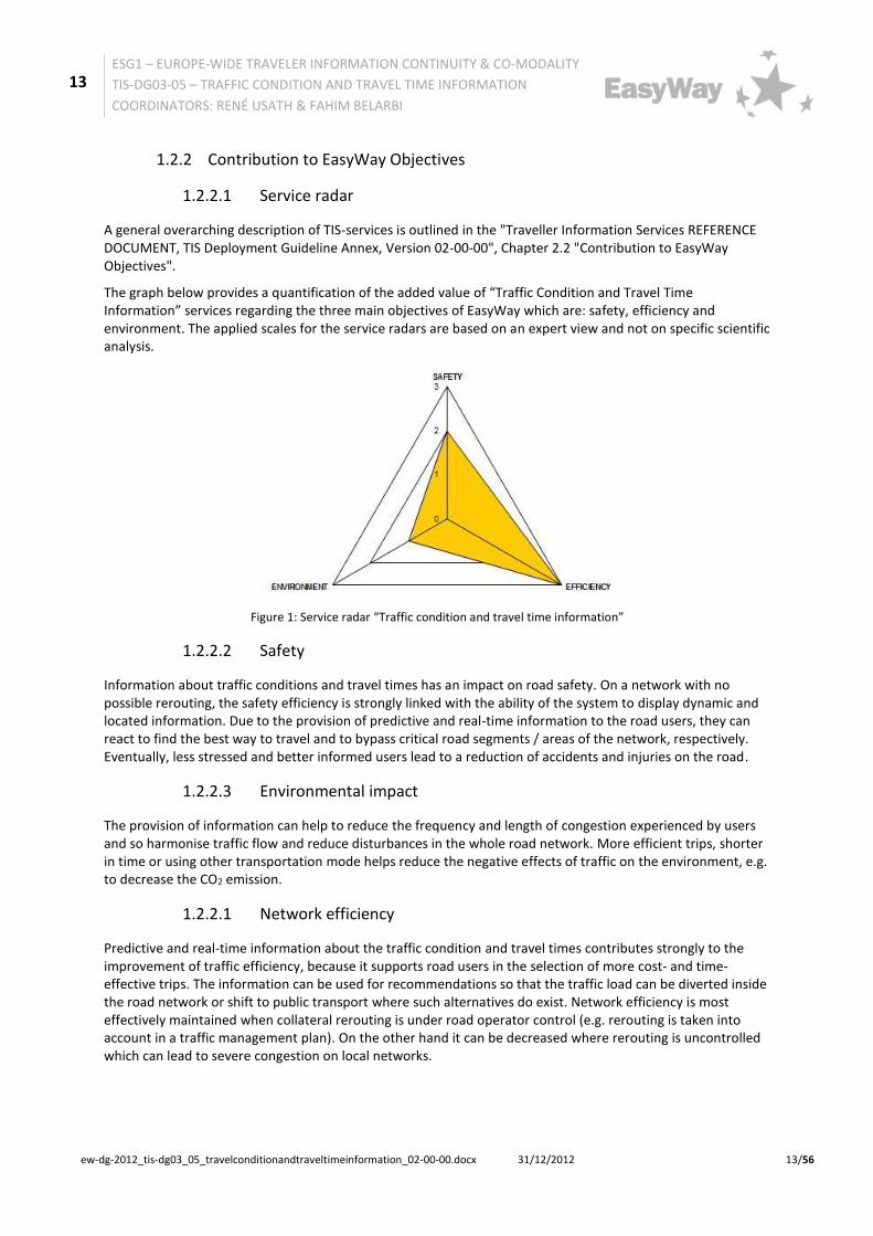
A general overarching description of TIS-services is outlined in the "Traveller Information Services REFERENCE DOCUMENT, TIS Deployment Guideline Annex, Version 02-00-00", Chapter 2.2 "Contribution to EasyWay Objectives".
The graph below provides a quantification of the added value of “Traffic Condition and Travel Time Information” services regarding the three main objectives of EasyWay which are: safety, efficiency and environment. The applied scales for the service radars are based on an expert view and not on specific scientific analysis.
Figure 1: Service radar “Traffic condition and travel time information”
1.2.2.2 Safety
Information about traffic conditions and travel times has an impact on road safety. On a network with no possible rerouting, the safety efficiency is strongly linked with the ability of the system to display dynamic and located information. Due to the provision of predictive and real-time information to the road users, they can react to find the best way to travel and to bypass critical road segments / areas of the network, respectively. Eventually, less stressed and better informed users lead to a reduction of accidents and injuries on the road.
1.2.2.3 Environmental impact
The provision of information can help to reduce the frequency and length of congestion experienced by users and so harmonise traffic flow and reduce disturbances in the whole road network. More efficient trips, shorter in time or using other transportation mode helps reduce the negative effects of traffic on the environment, e.g. to decrease the CO2 emission.
1.2.2.1 Network efficiency
Predictive and real-time information about the traffic condition and travel times contributes strongly to the improvement of traffic efficiency, because it supports road users in the selection of more cost- and time-effective trips. The information can be used for recommendations so that the traffic load can be diverted inside the road network or shift to public transport where such alternatives do exist. Network efficiency is most effectively maintained when collateral rerouting is under road operator control (e.g. rerouting is taken into account in a traffic management plan). On the other hand it can be decreased where rerouting is uncontrolled which can lead to severe congestion on local networks.
14
ESG1 – EUROPE-WIDE TRAVELER INFORMATION CONTINUITY & CO-MODALITY
TIS-DG03-05 – TRAFFIC CONDITION AND TRAVEL TIME INFORMATION
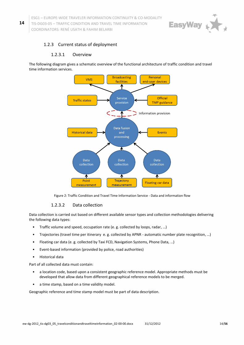
The following diagram gives a schematic overview of the functional architecture of traffic condition and travel time information services.
Figure 2: Traffic Condition and Travel Time Information Service - Data and information flow
1.2.3.2 Data collection
Data collection is carried out based on different available sensor types and collection methodologies delivering the following data types:
• Traffic volume and speed, occupation rate (e. g. collected by loops, radar, …)
• Trajectories (travel time per itinerary e. g. collected by APNR - automatic number plate recognition, …)
• Floating car data (e. g. collected by Taxi FCD, Navigation Systems, Phone Data, …)
• Event-based information (provided by police, road authorities)
• Historical data
Part of all collected data must contain:
• a location code, based upon a consistent geographic reference model. Appropriate methods must be developed that allow data from different geographical reference models to be merged.
• a time stamp, based on a time validity model.
Geographic reference and time stamp model must be part of data description.
15
ESG1 – EUROPE-WIDE TRAVELER INFORMATION CONTINUITY & CO-MODALITY
TIS-DG03-05 – TRAFFIC CONDITION AND TRAVEL TIME INFORMATION
Note: "Data fusion and procession" includes “data validation and certification”.
Traffic condition (LoS) Information
Merging and aggregating data from different sources (data-fusion) is the basis of LoS calculation. Within Europe different methodologies and traffic models exist to aggregate the real-time and predictive traffic condition and travel time information.
The result is the so called Level of Service, which consists of different traffic states (See also 2.5 Common Look & feel), which are depicted in a map by colouring route segments or links.
Travel time Information
Travel time information is easy to understand but it is more complex to calculate. Indeed, various algorithms are commonly used .in the process of travel time calculation. Here after are listed definitions of usual travel times' intermediate values. These values have to be consolidated before dissemination to ensure information consistency for the end user. Final information consistency is both conditioned by the reliability of the input raw data and the accuracy of the calculation model.
• Instantaneous Travel Time (ITT)
Real time processed on every network section, based on the raw data measured by counting stations. This travel time consists in the sum of each elementary section ITT. Input raw data: Flow rate, Occupation rate, speed.
• Output Rebuilt Travel Time (ORTT)
Retroactively processed, based on the raw data measured by counting stations. Input raw data: Flow rate, Occupation rate, speed. The result is evaluated using a fictitious vehicle and historical speeds.
• Estimated Travel Time (ETT)
Retroactively calculated, using for examples measures from tolls transactions. Travel times of outbound vehicles are filtered to get reliable results.
• Mixed Travel Time (MTT)
This is a combination of the ORTT and the ETT, using the principle of data fusion. Data fusion can be based on a linear relation or a strategy more complex.
• Forecast Travel Time (FTT)
Based on the reproducibility of the road traffic, the FTT is built through prediction models, applied to historical measures databases. Input raw data: Flow rate, Occupation rate, Speed.
Please note that each of the intermediate travel times above is more or less appropriate depending on the road context. The one to be used in the calculation process has to be selected in relation with various criteria (e.g. network characteristics, traffic profile, etc.)
1.2.3.4 Service provision
There are various European services in operation which can be distinguished according to the information providers, i.e.:
• Public road authorities, acting as road operators
• Private road operators
• Broadcasters
• Other private service providers
Service providers can be differentiated between:
16
ESG1 – EUROPE-WIDE TRAVELER INFORMATION CONTINUITY & CO-MODALITY
TIS-DG03-05 – TRAFFIC CONDITION AND TRAVEL TIME INFORMATION
• those who provide common, non-personalised information (e.g. by VMS or radio broadcasting) to a wide spectrum of users including a judgement of what is thought most important to the largest number of users and then leaving it to the users to deduce what is the best course of action to take,
• those who offer individual (personalised, on-demand) information and
• those who provide information of the first basis may use display channels such as e.g. road side information panels (VMS) which are exclusively the responsibility of road operators, whereas internet based traffic information services can be also provided by private service providers.
1.2.3.5 Information channels
Different information channels could be used for the provision of the service to the road user:
• roadside information infrastructure of road operators (own VMS, VMS of other road operators)
• data communication: RDS-TMC (FM), TPEG (DAB, DBM)
• mobile radio (2G (GPRS), 3G (UMTS), 4G (LTE)): TPEG
• I2V (infrastructure to vehicle facilities): e.g. citizen band radio, FM radio – in future cooperative systems
1.2.3.6 End-user devices
End user access to traffic condition and travel time information is possible by different end-user devices.
• Roadside information panels (e.g. VMS)
• End user devices with internet access (stationary devices as PCs, TVs and other stationary internet-connected devices, tablets, mobile phones, smart phones, …)
• End user devices without internet access for static information provision (the same as above)
• Navigation systems
• by mobile radio connected PNDs (e.g. TPEG or proprietary interfaces)
• RDS-TMC / TPEG (broadcast)
• Television (videotext, dedicated channels, Internet-based)
• Radio (spoken, text to speech)
• Radio (data, text)
In-car systems (end user terminals) offer the advantage that they can take into account vehicle-type based speed limits or other vehicle-type based restrictions (see EasyWay deployment guideline TIS-DG04: Speed limit information service).
17
ESG1 – EUROPE-WIDE TRAVELER INFORMATION CONTINUITY & CO-MODALITY
TIS-DG03-05 – TRAFFIC CONDITION AND TRAVEL TIME INFORMATION
The table below shows the different end-user devices with the reference to some attributes.
Ro
adsi
de
Info
rmat
ion
Pan
els
(VM
S)
Internet based Devices
Nav
igat
ion
Sys
tem
s
RD
S-TM
C/
TPE
G b
ased
dev
ices
Rad
io (
spo
ken
)
Tele
visi
on
Stat
ion
ary
dev
ices
Mo
bile
Dev
ice
s
Pre-trip use n y y y n (y) y y
On-trip use y n y (n) y y y n
Language independent n (y) n n y y n n
Information provision by road operators
Y Y y n n (y) n (y) n
Information provision by other parties
n y y y y y y
Table 2: Characteristics of the different end-user devices (n=no, y=yes)
1.2.4 European Dimension
Ideally traffic condition and travel time information should at the European dimension provide continuity across neighbouring regions and between member states. Thus the purpose of this Deployment Guideline is to develop the existing services towards a truly European (pan-European) service and to assure an adequate service quality (Level of service). The European continuity aspects are:
• the service coverage (geographical and time availability),
• the continuity as regards content across corridors and TEN-T network and interfaces,
• the language-independence characteristics and
• the provision of information about the existence and the price of use of the services and how to access.
Provision of information by means of pictograms or colours on a digital map tends to be language independent, but the pictograms and colours are not uniform across Europe at present. Complementary information (spoken or text) requires translation and provision in different languages.
18
ESG1 – EUROPE-WIDE TRAVELER INFORMATION CONTINUITY & CO-MODALITY
TIS-DG03-05 – TRAFFIC CONDITION AND TRAVEL TIME INFORMATION
2 Part A: Harmonization Requirements 2.1 Service Definition
"Traffic condition and travel time information service” means, both pre-trip and on-trip, the provision of traffic condition (LoS) and travel time information on identified road segments of the TEN-T network and interfaces, thus enabling road users to optimize and better anticipate their journey ahead. This predictive or real-time information will use different information channels, accessible by the road user via different end-user devices. The service may comprise common as well as individual (personalised, on-demand) information.
2.2 Functional Requirements
2.2.1 Functional architecture
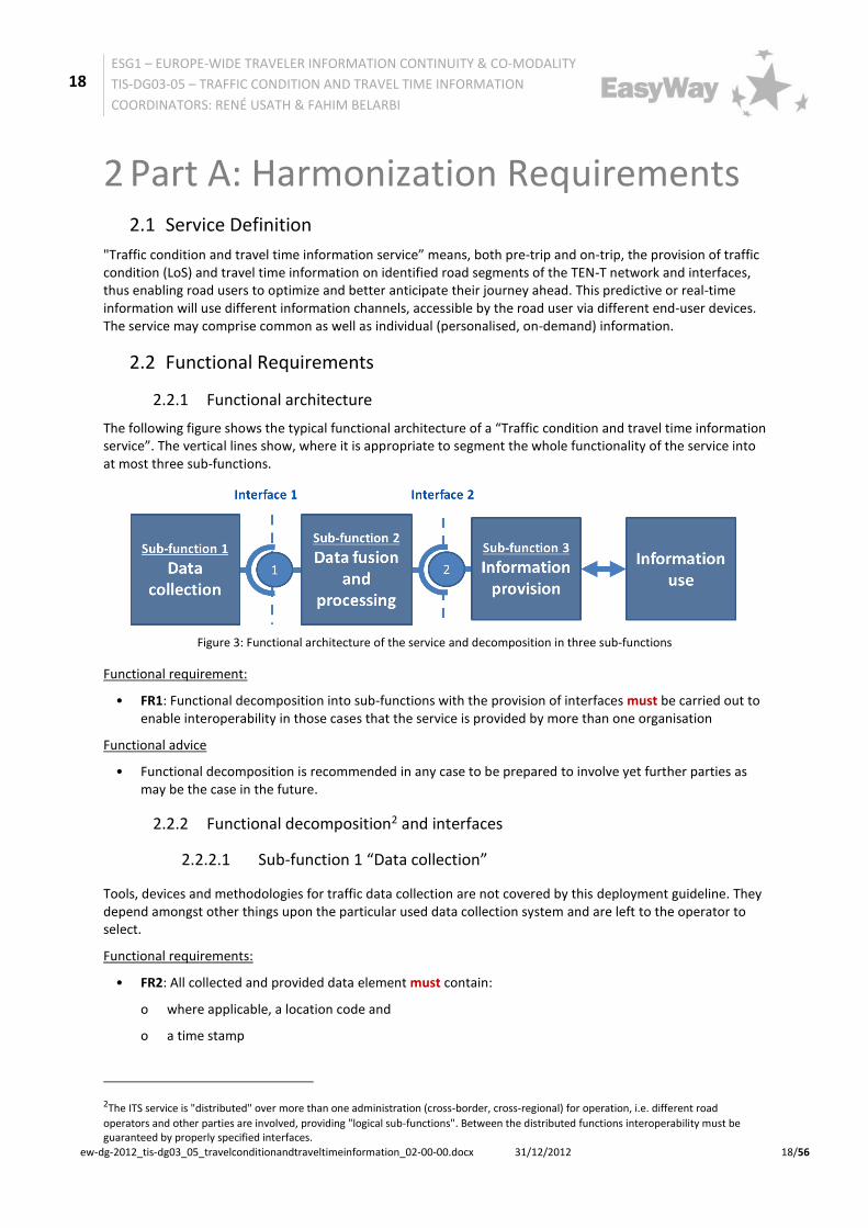
The following figure shows the typical functional architecture of a “Traffic condition and travel time information service”. The vertical lines show, where it is appropriate to segment the whole functionality of the service into at most three sub-functions.
Figure 3: Functional architecture of the service and decomposition in three sub-functions
Functional requirement:
• FR1: Functional decomposition into sub-functions with the provision of interfaces must be carried out to enable interoperability in those cases that the service is provided by more than one organisation
Functional advice
• Functional decomposition is recommended in any case to be prepared to involve yet further parties as may be the case in the future.
2.2.2 Functional decomposition2 and interfaces
2.2.2.1 Sub-function 1 “Data collection”
Tools, devices and methodologies for traffic data collection are not covered by this deployment guideline. They depend amongst other things upon the particular used data collection system and are left to the operator to select.
Functional requirements:
• FR2: All collected and provided data element must contain:
o where applicable, a location code and
o a time stamp
2The ITS service is "distributed" over more than one administration (cross-border, cross-regional) for operation, i.e. different road
operators and other parties are involved, providing "logical sub-functions". Between the distributed functions interoperability must be guaranteed by properly specified interfaces.
19
ESG1 – EUROPE-WIDE TRAVELER INFORMATION CONTINUITY & CO-MODALITY
TIS-DG03-05 – TRAFFIC CONDITION AND TRAVEL TIME INFORMATION
The geographical basis of the location code should be left to the road operator to define, anyway the model of information provision to other organisations must respect DATEX II location reference and time stamp models.
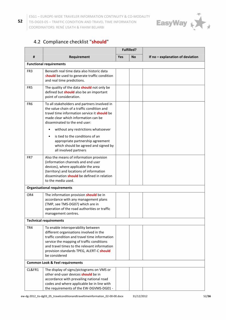
• FR3: Beneath real time data also historic data should be used to generate traffic condition and real time predictions.
2.2.2.2 Sub-function 2 “Data fusion and processing”
Note: "Data fusion and procession" includes “data validation and certification”.
Within Europe different methodologies exist to aggregate the real-time and predictive traffic condition and travel time information. These methodologies are not covered by the present guideline and are left to the operator to select. They depend amongst others on the particular used data fusion and processing system and particularly traffic model applied.
Functional requirement:
• FR4: Source, scope and quality (based on a quality model to be defined) of data provided by content owners3 to content providers must be defined by the partners and must be part of data interface description.
• FR5: The quality of the data should not only be defined but should also be an important point of consideration.
2.2.2.3 Sub-function 3 “Information provision”
Information provision is carried out by different service providers in accordance with specific business models. The information provision to the road user on end-user devices has to be done using various information channels (see 1.2.1.5 “Information channels”).
Functional requirements:
• FR6: To all stakeholders and partners involved in the value chain of a traffic condition and travel time information service it should be agreed and signed acceptable under which conditions information can be disseminated to the end user:
o without any restrictions whatsoever
o tied to the conditions of an appropriate partnership agreement which should be agreed and signed acceptable by all involved partners
• FR7: Also the means of information provision (information channels and end user devices), where applicable the area (territory) and locations of information dissemination should be defined in relation to the media used
2.2.2.4 Interface requirements
Note: If the ITS service is "distributed" over more than one administration (cross-border, cross-regional) for operation, i.e. different road operators and other parties are involved, providing "logical sub-functions", interoperability between the distributed functions must be guaranteed by properly specified interfaces.
Interface requirement interface 1 (see also Technical requirements, DATEX II-profiles):
• FR8: To enable interoperability between all involved parties the sub-functions data collection and data fusion and processing must - depending on the used data type for the data fusion and processing -require/provide an interface 1 with one or several of the following information structures:
o traffic volume and speed, occupation rate (e. g. collected by loops, radar, …)
3 Definition and description of the key actors: see "Traveller Information Services REFERENCE DOCUMENT, TIS Deployment Guideline Annex, Version 02-00-00", Chapter 3.1
20
ESG1 – EUROPE-WIDE TRAVELER INFORMATION CONTINUITY & CO-MODALITY
TIS-DG03-05 – TRAFFIC CONDITION AND TRAVEL TIME INFORMATION
o trajectories (travel time per itinerary e. g. collected by APNR - automatic number plate recognition, video…)
o floating car data (e. g. collected by Taxi FCD, Navigation Systems, Phone Data, …)
Interface requirement interface 2 (see also Technical requirements, DATEX II-profiles):
• FR9: To enable interoperability between all involved parties (see FR1) the sub-functions data fusion and processing and service provision must require/provide an interface using the appropriate DATEX II-profile as described by requirement TR2, consisting of the following elements:
o Level of Service
o traffic states
o Travel times
Note: The required/provided information content depends on availability and the levels of quality criteria table agreed among the partners involved
Interface Advice interface 2:
• In order to provide efficient and adapted information when needed and also to prevent from disseminating counterproductive information additionally event-based information and official traffic management plans should be provided, which are covered by other EasyWay deployment guidelines (See TIS-DG02 "Forecast and Real Time Event Information" and TMS-DG07 "Traffic management plan for corridors and networks")
21
ESG1 – EUROPE-WIDE TRAVELER INFORMATION CONTINUITY & CO-MODALITY
TIS-DG03-05 – TRAFFIC CONDITION AND TRAVEL TIME INFORMATION
A general overarching description of the key actors, their roles in the value chain and the related conditions for TIS-service provision is outlined in the "Traveller Information Services REFERENCE DOCUMENT, TIS Deployment Guideline Annex, Version 02-00-00":
• Chapter 3.1 "Introduction to key actors in the traveller information chain" and
• Chapter 3.2 "Conditions for Service Provision - Business Model"
The following picture shows the historical grown organisational architecture of the traffic condition and travel time service:
Figure 4: traffic condition and travel time information service – organisational architecture (historical)
Currently the models for distribution of data are changing dramatically. Various possible combinations of cooperation between road operators and others parties show the following figures:
Figure 5: Organisational architecture – road operator point of view
Road Operators Road Operators Road Operators PC, Mobile Phone
VMS
Data collectionData fusion and
processionInformation
provision
Information use
PC, Tablet, Mobile Phone
TV , Radio, Videotext
RDS
Navigation devices
Others Others Others
Radio
Road Operators Road Operators Road Operators
Data collectionData fusion and
processionInformation
provisionInformation use
Road Operators Road Operators Road Operators
Others Others
Road Operators Road Operators Road Operators
Others
A
Case
B
C
PC, Mobile Phone
VMS
Radio
PC, Mobile Phone
VMS
Radio
PC, Mobile Phone
VMS
Radio
22
ESG1 – EUROPE-WIDE TRAVELER INFORMATION CONTINUITY & CO-MODALITY
TIS-DG03-05 – TRAFFIC CONDITION AND TRAVEL TIME INFORMATION
Figure 6: Organisational architecture – others (not road operator) point of view
Note: Even though partners can be either public or private road organisations as well as public or private service providers, who are legally autonomous in varying degrees and in the international context sometimes even work on different national laws, it is not required to define organisational aspects on a legal and binding basis.
Organisational advice:
• Where different autonomous parties are involved, clear definitions of organisational aspects are a crucial precondition for a successful implementation of a "Forecast and real-time event information service". These definitions should be documented in the form of e.g. a “Common partner arrangement” or a “MoU - Memorandum of understanding” which establishes the roles and responsibilities of the respective parties to any co-operation and is then agreed upon by all parties/partners involved.
The documents should also define modes of co-operation in a set of operational instructions. They should be thoroughly checked and verified prior to acceptance. These documents are a declaration of intent of the rules of engagement but are not legally binding. The agreement should be concluded in written form, on the one hand, because the service provision requires a clear understanding of the co-operation, but on the other hand because it can be seen as a milestone in the negotiation which may also provide an appropriate media opportunity.
A new challenge is the ever increasing number of public-private partnerships in the TIS-services. In these circumstances, where private stakeholders execute sovereign tasks or receive data, binding contracts should be developed and finalised. Another current aspect is the use of private generated data for TIS-services. A contract (with service level agreement) should be compulsory wherever the service relies on receiving privately generated data.
Organisational requirements:
• OR1: The organisational and operational structure of the service as well as the role of each public organisation/body and its exact roles and tasks in the chain must be defined
23
ESG1 – EUROPE-WIDE TRAVELER INFORMATION CONTINUITY & CO-MODALITY
TIS-DG03-05 – TRAFFIC CONDITION AND TRAVEL TIME INFORMATION
• OR2: All for successful implementation of a "Traffic condition and travel time information service" necessary organisational aspects must be documented and agreed by all involved parties/partners to fix the co-operation.
• OR3: All necessary collaboration processes/workflows and interfaces must be described
• OR4: The information provision should be in accordance with any management plans (TMP, see TMS-DG07) which are in operation of the road authorities or traffic management centres.
24
ESG1 – EUROPE-WIDE TRAVELER INFORMATION CONTINUITY & CO-MODALITY
TIS-DG03-05 – TRAFFIC CONDITION AND TRAVEL TIME INFORMATION
2.4.2 Standards and Agreements: Existing and Required
2.4.2.1 DATEX II-Profiles
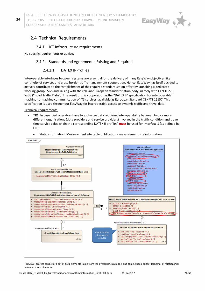
Interoperable interfaces between systems are essential for the delivery of many EasyWay objectives like continuity of services and cross-border traffic management cooperation. Hence, EasyWay has itself decided to actively contribute to the establishment of the required standardisation effort by launching a dedicated working group ESG5 and liaising with the relevant European standardisation body, namely with CEN TC278 WG8 (“Road Traffic Data”). The result of this cooperation is the “DATEX II” specification for interoperable machine-to-machine communication of ITS services, available as European Standard CEN/TS 16157. This specification is used throughout EasyWay for interoperable access to dynamic traffic and travel data.
Technical requirements:
• TR1: In case road operators have to exchange data requiring interoperability between two or more different organisations (data providers and service providers) involved in the traffic condition and travel time service value chain the corresponding DATEX II profiles4 must be used for interface 1 (as defined by FR8):
o Static information: Measurement site table publication - measurement site information
4 DATEXII profiles consist of a set of data elements taken from the overall DATEX model and can include a subset (schema) of relationships
between those elements
25
ESG1 – EUROPE-WIDE TRAVELER INFORMATION CONTINUITY & CO-MODALITY
TIS-DG03-05 – TRAFFIC CONDITION AND TRAVEL TIME INFORMATION
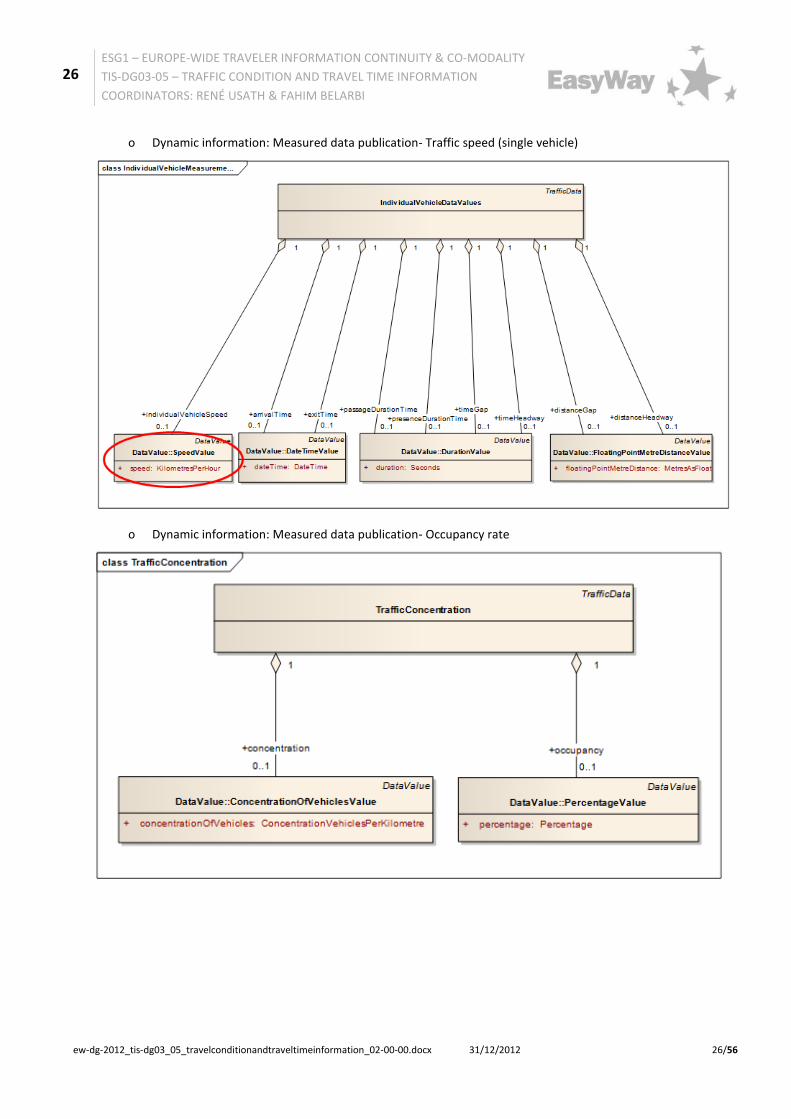
• TR2: In case road operators have to exchange data requiring interoperability between two or more different organisations (data providers and service providers) involved in the traffic condition and travel time information service value chain the corresponding DATEXII profiles must be used for interface 2 (as defined by FR9):
o Dynamic information: Elaborated data publication - Level of Service (LoS)
30
ESG1 – EUROPE-WIDE TRAVELER INFORMATION CONTINUITY & CO-MODALITY
TIS-DG03-05 – TRAFFIC CONDITION AND TRAVEL TIME INFORMATION
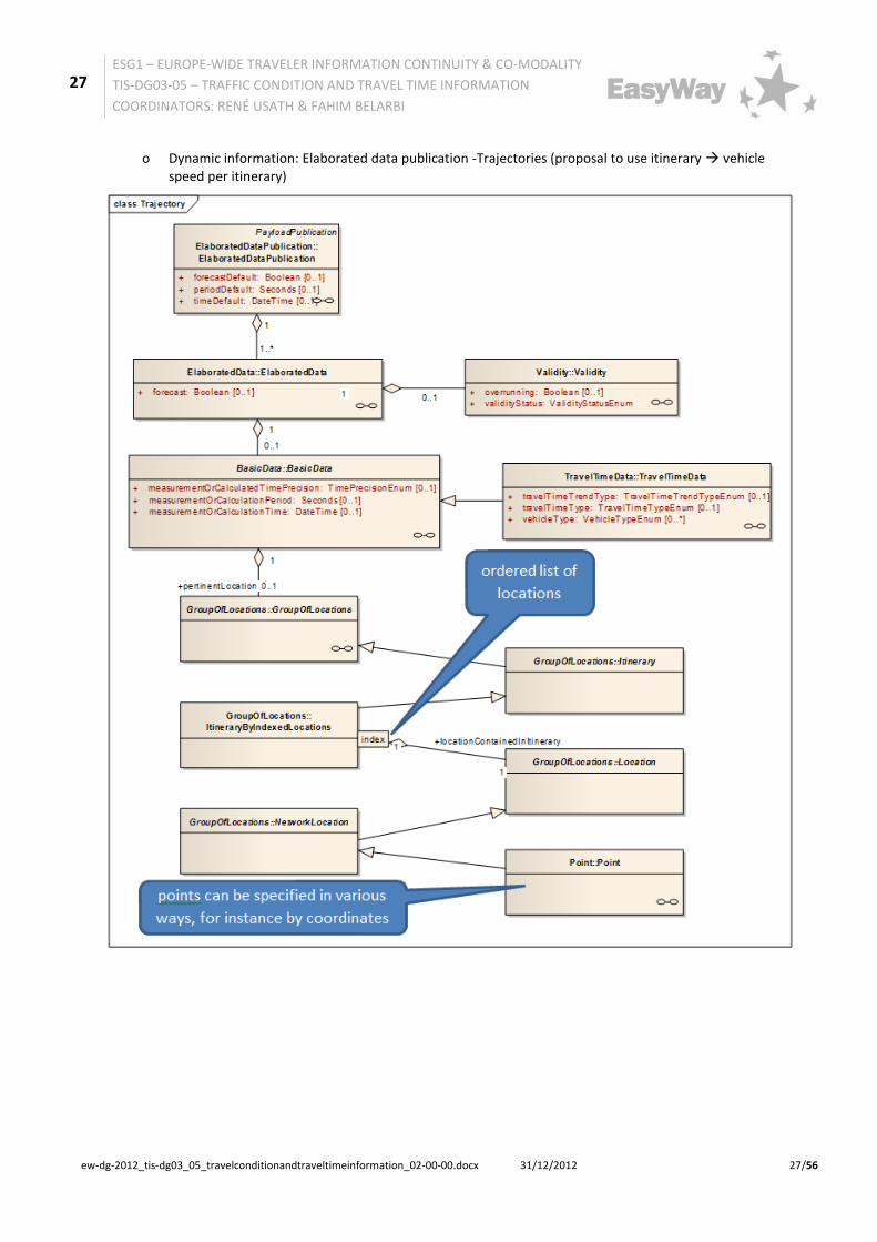
o Dynamic information: Elaborated data publication - Travel times
• TR3: To guarantee reliable exchange of location information a consistent location code model as specified in FR2 must always be used.
Note: EasyWay provides DATEX II profiles to support core service deployment in the domains of Traffic Management, Traffic Information and Freight & Logistics services. These profiles describe a subset of the DATEX II data model, tailored to the needs of the particular core service. If these deployments have a special requirement to support particular downstream standards used in subsequent stages of the service delivery chain, it may become important to tailor these profiles further and to use only the cross-section between the TIS/TMS/FLS-DGnn profile and a DATEX profile tailored for interoperability to the particular downstream standard.
As an example, a TIS profile may allow for multiple location referencing methods, but if dissemination of the information via RDS-TMC is envisaged by a particular deployment, compliance with the ALERT-C standard is essential since this standard only supports the use of ISO 14819-3 location codes. Hence, it might be
31
ESG1 – EUROPE-WIDE TRAVELER INFORMATION CONTINUITY & CO-MODALITY
TIS-DG03-05 – TRAFFIC CONDITION AND TRAVEL TIME INFORMATION
preferable to tailor the EasyWay TIS profile further to use only ALERT-C location codes to ensure that the service provider can use the data provided.
Technical requirement:
• TR4: To enable interoperability between different organisations involved in the traffic condition and travel time information service the mapping of traffic conditions and travel times to the relevant information provision standards TPEG, ALERT-C should be considered.
2.4.2.2 Need for Additional Specifications
None
32
ESG1 – EUROPE-WIDE TRAVELER INFORMATION CONTINUITY & CO-MODALITY
TIS-DG03-05 – TRAFFIC CONDITION AND TRAVEL TIME INFORMATION
• The core message of information provided for the end user should always be consistent, whatever media or end user device is used for distribution.
Specifically according to traffic condition information
Common look & feel requirements:
• CL&FR1: The display of signs/pictograms on VMS or other end-user devices should be in accordance with prevailing national road codes and where applicable be in line with the requirements of the EW-DGVMS-DG01 - VMS Message Design Principles:
o MS which ratified the 1968 Convention MUST respect the 1968 Convention and SHOULD consider the Consolidated Resolution on Road Signs and Signals (R.E.2);
o MS which did sign but not ratified the 1968 Convention SHOULD follow the 1968 Convention and also consider the R.E.2.
o It is up to the deploying road operator to ensure that real signs are well and widely understood by the road users.
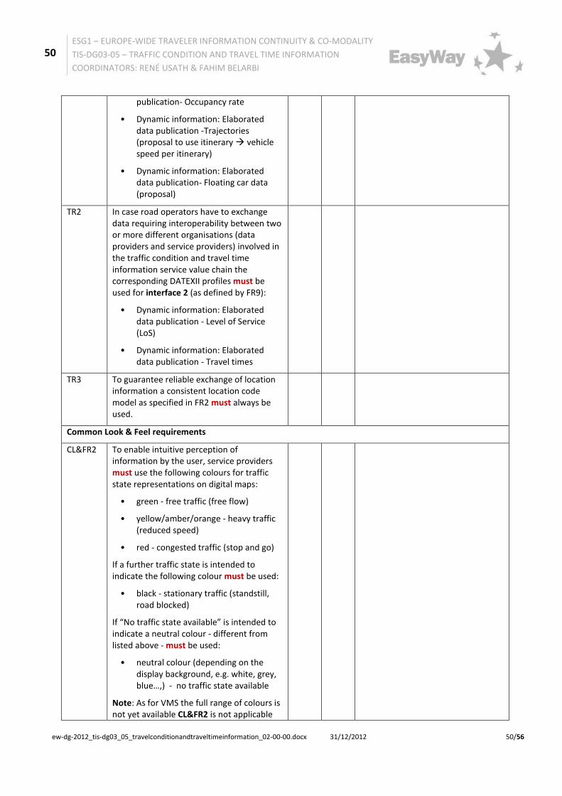
• CL&FR2: To enable intuitive perception of information by the user, service providers must use the following colours for traffic state representations on digital maps:
o green - free traffic (free flow)
o yellow/amber/orange - heavy traffic (reduced speed)
o red - congested traffic (stop and go)
o If a further traffic state is intended to indicate the following colour must be used:
o black - stationary traffic (standstill, road blocked)
o If “No traffic state available” is intended to indicate a neutral colour - different from listed above - must be used:
o neutral colour (depending on the display background, e.g. white, grey, blue…,) - no traffic state available
Note: As for VMS the full range of colours is not yet available CL&FR2 is not applicable for the depiction of digital maps on VMS.
Specifically according to travel time information
Common look & feel requirements:
• CL&FR3: The display of travel times and delay times on VMS or other end-user devices (websites, navigation systems…) should respect the following format: <XX> min.
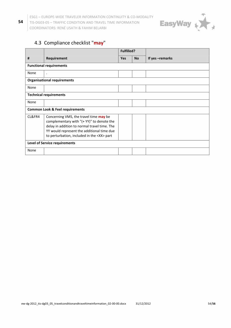
• CL&FR4: Concerning VMS, the travel time may be complementary with "(+ YY)" to denote the delay in addition to normal travel time. The YY would represent the additional time due to perturbation, included in the <XX> part.
• CL&FR5:It should always be indicated for which location (intersection, exit, city ...) the travel time displayed is valid.
Common look & feel advice:
• Every VMS or other end-user devices providing information about abnormal travel time should also inform as well on the traffic situation.
33
ESG1 – EUROPE-WIDE TRAVELER INFORMATION CONTINUITY & CO-MODALITY
TIS-DG03-05 – TRAFFIC CONDITION AND TRAVEL TIME INFORMATION
The scope of EasyWay is to provide Core European Services to the European road users. These services are harmonized in content and functionality, but also in their availability: The road users shall be able to expect a certain services offer in a specific road operating environment. In order to provide a basis for the harmonization process EasyWay needs a tool to define such environments in an agreed manner. This tool is the Operating Environments – a set of pre-defined road environments combining physical layout of the road and network typology with traffic characteristics.
In essence, EasyWay has agreed on a set of 18 pre-defined Operating Environments (OE) where each OE is a combination of three criteria:
• Physical characteristics – Motorways, other 3/4 lane roads or 2-lane roads
• Network typology – Corridor, Network, Link or Critical spot
For more information and details, visit http://www.easyway-its.eu/document-center/document/open/490/ and download the Guidance for Classifying the EasyWay Network into OE ver 1.0.
2.6.2 Level of Service Criteria
The Levels of Service (LoS) definition of Traffic condition and travel time Information Services follows the general Levels of Service definition (core criteria) outlined in the "Traveller Information Services REFERENCE DOCUMENT, TIS Deployment Guideline Annex, Version 03-00-00" chapter 5.1 "Levels of service and quality"
Levels of Service Table: Travel Condition and Travel Time Information
Core Criteria A B C
User interface* One fixed language
(all official languages)
Information available is capable of being provided in addition in a common
and shared language.
Information available is capable of being provided independent of language
Neighbouring Provision
No information exchange
Information exchange to neighbouring only
Neighbouring and beyond information provider
exchange
Local and secondary Network Information
None (information only on TEN-T road
network)
Exchange and use of information for strategic non TEN-T road network
(key roads)
If necessary, additional information on local routes with impact on the TEN-T
road network
Level of Detail (Location Reference)
None Route specific segments
(between 2 junctions) Road segment specific
(approx.. 1 km)
Static / Dynamic Static/historical only Static/historical and partly
dynamic Static/historical and fully
dynamic
Legend:
*User interface concerns only Traffic condition information. This is not relevant for Travel Times, which are provided on a language independent way (digits for hours and minutes).
The “Levels of Quality Table” reflects the requirements of the data quality which are needed for "Traffic condition and travel time information services". This table is not end-user oriented as Table 3: Level of Service. The definitions of the below-mentioned table are according to the ISO/PDTR 21707i standard.
Levels of Quality Table: Traffic Condition and Travel Time Information Services
Criteria 0 1 2 3
Accessibility Only on hotspots On main routes where problems
often occur On all routes
Availability Not guaranteed Guaranteed to a minimum level
Guaranteed to a medium level
Guaranteed all the time
Timeliness Not guaranteed 30 min – 15 min 15 min – 1 min around 10 s
Update frequency
Only on an irregular basis
On a regular basis
As frequent as currently possible respectively as a
significant change of traffic conditions
occurs”.
Quality Assurance
No regulation Either input or output (partial
check)
Service chain check (full)
Information Quality Assurance
Cross Verified Not defined
Data from one or more sources – reliability not
confirmed
Data from one or more sources –
reliability confirmed
Collaboration from more than one
source (data fusion) – reliability confirmed
Accuracy N/A N/A N/A N/A
Service Grade Not guaranteed Guaranteed to a
time interval In real time
Forecast Horizon Only current
situation
Current situation and short time
prediction
Current situation and short as well as
long time prediction
Legend:
See "Traveller Information Services REFERENCE DOCUMENT, TIS Deployment Guideline Annex, Version 03-00-00", chapter 5.1 "Levels of Service and Quality "for core criteria definitions (Accessibility, Availability, Timeliness, Update Frequency, Quality Assurance, Cross Verified and Accuracy).
• Accuracy: This criterion is covered by
o LoS: Level of Detail and
o LoQ: Forecast Horizon.
• Service Grade: A specific traffic condition and travel time information quality criterion, in which the service is guaranteed.
• Forecast Horizon: A specific traffic condition and travel time information quality criterion, which defines the prediction time for the service.
Table 4: Levels of Quality table
35
ESG1 – EUROPE-WIDE TRAVELER INFORMATION CONTINUITY & CO-MODALITY
TIS-DG03-05 – TRAFFIC CONDITION AND TRAVEL TIME INFORMATION
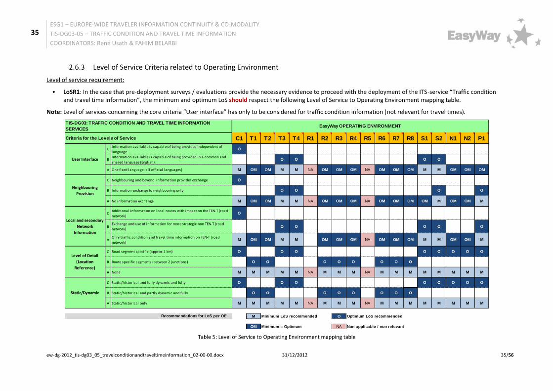
2.6.3 Level of Service Criteria related to Operating Environment
Level of service requirement:
• LoSR1: In the case that pre-deployment surveys / evaluations provide the necessary evidence to proceed with the deployment of the ITS-service “Traffic condition and travel time information”, the minimum and optimum LoS should respect the following Level of Service to Operating Environment mapping table.
Note: Level of services concerning the core criteria “User interface” has only to be considered for traffic condition information (not relevant for travel times).
Table 5: Level of Service to Operating Environment mapping table
3 Part B: Supplementary Information EasyWay Deployment Guidelines are twofold:
• Part A elaborates on the content of the ITS service addressed, including the entire deployment framework including Requirements and Levels of Services.
• Part B is an appendix of educational content. Its objective is to illustrate part A with examples and feedback from deployments in the field.
This lively chapter is subject to continuous development and update. It consists in a database of national practices and experiences which, as cross-fertilisation material, can benefit any road operator in Europe.
Bearing in mind the cyclic nature of the elaboration of EasyWay Deployment Guidelines, one can assume that the first edition of the 2012 Guidelines will not yet include users’ experience on its content. Forthcoming ITS deployments based on part A of this Deployment Guideline will generate feedback which will in-turn be integrated into the next revised version of part B.
3.1 Examples of deployment
3.1.1 Roadside guidance systems
Roadside guidance systems are installed on the motorways and will be operated by the road authorities or the private motorway companies. The systems consist of VMS or dynamic signage with predefined content. The systems display directional information, diversion information but also information about the traffic conditions incl. travel-time, warnings and weather conditions. Due to the installation on the road the service is usable only on-trip.
Figure 7:VMS on the A10 near Madrid in Spain
38
ESG1 – EUROPE-WIDE TRAVELER INFORMATION CONTINUITY & CO-MODALITY
TIS-DG03-05 – TRAFFIC CONDITION AND TRAVEL TIME INFORMATION
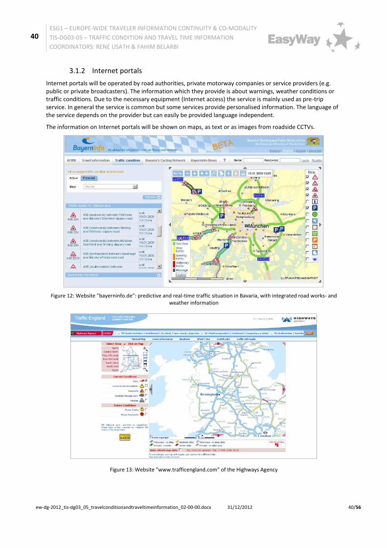
Internet portals will be operated by road authorities, private motorway companies or service providers (e.g. public or private broadcasters). The information which they provide is about warnings, weather conditions or traffic conditions. Due to the necessary equipment (Internet access) the service is mainly used as pre-trip service. In general the service is common but some services provide personalised information. The language of the service depends on the provider but can easily be provided language independent.
The information on Internet portals will be shown on maps, as text or as images from roadside CCTVs.
Figure 12: Website "bayerninfo.de": predictive and real-time traffic situation in Bavaria, with integrated road works- and weather information
Figure 13: Website "www.trafficengland.com" of the Highways Agency
41
ESG1 – EUROPE-WIDE TRAVELER INFORMATION CONTINUITY & CO-MODALITY
TIS-DG03-05 – TRAFFIC CONDITION AND TRAVEL TIME INFORMATION
Figure 14: Website "www.autobahn.nrw.de" of the road authority of North Rhine-Westphalia
Figure 15: Spanish eTraffic service: Traffic condition and travel time
3.1.3 Navigation systems
Navigation systems provide routing information to the chosen destination. The system uses static or dynamic information to reach the destination. The dynamic information can be provided via RDS-TMC or TPEG. With the provided dynamic information a flexible routing is possible and takes into account the current traffic condition, routing information and warnings. The service can be given to the road user via voice announcements, graphical display or a combination of both. The information can only be used on-trip and is language independent.
3.1.4 Mobile devices
Information which can be called with mobile phones by the road users will be provided by radio broadcasters or private service providers. The coverage of the different services is Europe-wide. Due to the determination of the geographical position via the mobile device the information can be provided personalised but also common. It can be given via Short Message Service, voice announcements or services, which depends on the
42
ESG1 – EUROPE-WIDE TRAVELER INFORMATION CONTINUITY & CO-MODALITY
TIS-DG03-05 – TRAFFIC CONDITION AND TRAVEL TIME INFORMATION
provider. Furthermore web-enable devices can also recall specific web-based traffic information. The information which will be provided is about the traffic condition, warnings and weather conditions. The service is used as pre-trip as well as on-trip information. Due to safety reasons the national regulations of the use of mobile phones while driving has to be taken into account.
Figure 16: Mobile device with traffic condition information service
Both, navigation systems as well as mobile devices have the great advantage that they can give individualized information and restrictions (e.g. vehicle-type-based speed limits).
3.1.5 RDS-TMC / TPEG
• RDS-TMC
RDS-TMC is a specific application of FM RDS used for broadcasting real-time traffic and weather information. Data messages are received silently and decoded by a TMC-equipped navigation system or radio and offering dynamic route guidance. The data is language independent and can be used as pre-trip or on-trip information service. RDS-TMC is a global standard and covers a large percentage of the TERN. Many parts of the TERN have no RDS-TMC coverage, however this could be provided at any time by commercial entities without market intervention by the State, or by the State if considered appropriate. The referencing based on the country-specific location code lists for the strategic European road network.
• TPEG
TPEG is a standardised world-wide technology which delivers all types of traffic and travel information content by different digital channels, e.g. digital Radio (DAB), Internet. It is language independent and can be used as on-trip or pre-trip information. The TPEG applications use a common location referencing method for all devices presenting text or icons on a map display.
3.1.6 Radio
Common radio broadcasters or special traffic radio broadcasters are available all over Europe. They give traffic condition information, warning information and weather information to the road user. Radio services may consist of spoken messages (amongst others the instantaneous warnings for wrong-way drivers), text to speech services or data services, all editorially provided with appropriate quality control.
This information is common and not personalised to the specific road user, but can be tailored to a specific area or region. The character and the mass of information depend on each broadcaster.
The information is in general not language independent and is normally an on-trip service but can also be used as pre-trip service. Broadcasters can be public or private bodies.
43
ESG1 – EUROPE-WIDE TRAVELER INFORMATION CONTINUITY & CO-MODALITY
TIS-DG03-05 – TRAFFIC CONDITION AND TRAVEL TIME INFORMATION
Figure 19: Traffic radio in England operated by the Highways Agency
3.1.7 Videotext
Videotext is provided in parallel to the TV programme. The broadcasting stations provide relevant traffic information (e.g. traffic conditions, warnings, regional traffic information of conurbations). The use of videotext is only a pre-trip service and usually not language independent.
Videotext services are currently being enhanced: novel, Internet-supported portals offer ease-of-use information-services for HDTVs and Internet-connected TVs.
Figure 20: Traffic information via videotext of the German broadcaster WDR
44
ESG1 – EUROPE-WIDE TRAVELER INFORMATION CONTINUITY & CO-MODALITY
TIS-DG03-05 – TRAFFIC CONDITION AND TRAVEL TIME INFORMATION
Some broadcasters in Europe provide special services on TV concerning the publication of traffic conditions. Particularly during the morning peak hours or in the case of poor weather conditions, large events or significant travel disruption. This service is not language independent and only a pre-trip service. The service on TV will be shown on maps, as texts, or on CCTV live streams.
Figure 21: Traffic Information via television on France 2
3.1.9 Audiotex in France
French Ministry provides a 24/7 free phone service about the road and motorway conditions throughout France. Audiotex is part of the Bison Futé service. The key objective is to provide as many road users as possible information in real-time. The provided information consist of roadworks, accidents, events, weather conditions, congestions, disruptions and diversions which is coming amongst others from the Gendarmerie, the Police, the road infrastructure, and the private motorway companies. Beside the phone service the website www.bison-fute.equipement.gouv.fr is in operation which provides further traffic related information for France.
Figure 22: Logo of the website and phone service Bison Futé
The information is checked, analysed and then passed on to the Bison Futé network, comprising the national centre for traffic information and seven regional traffic co-ordination and information centres covered all France.The availability and reliability of this phone service leads to a high level of quality.
45
ESG1 – EUROPE-WIDE TRAVELER INFORMATION CONTINUITY & CO-MODALITY
TIS-DG03-05 – TRAFFIC CONDITION AND TRAVEL TIME INFORMATION
Web link www.trafficscotland.org or m.trafficscotland.org (mobile site)
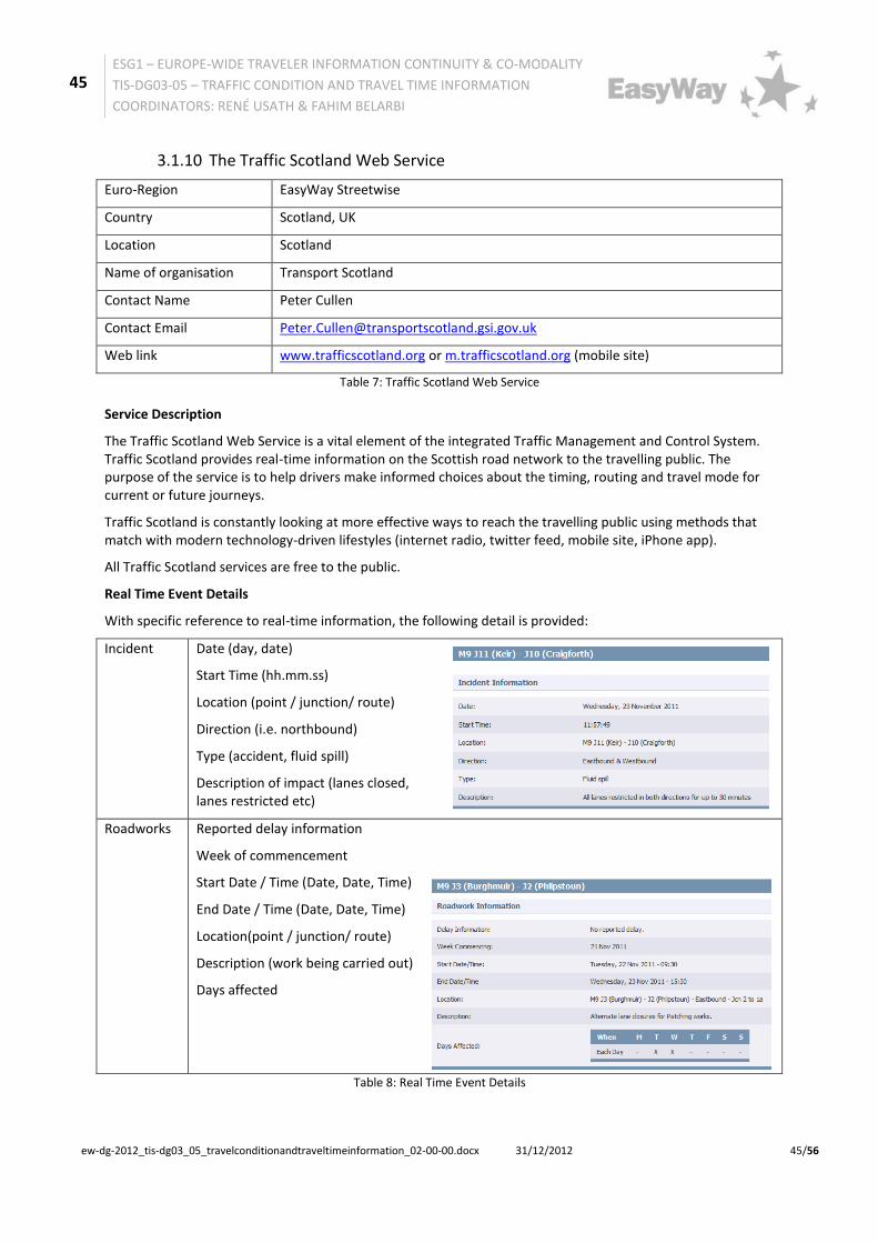
Table 7: Traffic Scotland Web Service
Service Description
The Traffic Scotland Web Service is a vital element of the integrated Traffic Management and Control System. Traffic Scotland provides real-time information on the Scottish road network to the travelling public. The purpose of the service is to help drivers make informed choices about the timing, routing and travel mode for current or future journeys.
Traffic Scotland is constantly looking at more effective ways to reach the travelling public using methods that match with modern technology-driven lifestyles (internet radio, twitter feed, mobile site, iPhone app).
All Traffic Scotland services are free to the public.
Real Time Event Details
With specific reference to real-time information, the following detail is provided:
Incident
Date (day, date)
Start Time (hh.mm.ss)
Location (point / junction/ route)
Direction (i.e. northbound)
Type (accident, fluid spill)
Description of impact (lanes closed, lanes restricted etc)
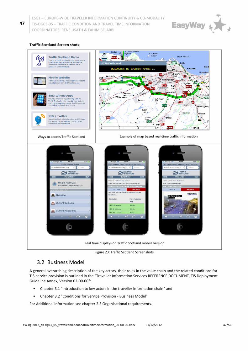
On mapping information is provided independent of language:
Icons used to show incidents, queues, roadworks
Colours used to road congestion / travel time links
Neighbouring Provision
DATEX II is used to exchange traffic data (incidents and travel times) with the Highways Agency in England
Local and secondary Network Information
DATEX II used to exchange travel time data with Edinburgh City Council connecting Transport Scotland TEN-T and local interfacing routes
Cooperation with external partners (i.e. organisers, local authorities, and the police) is also key when providing traffic information to the public on large events.
Level of Detail (Location Reference)
Dependant on type:
Point location (i.e. bridge / junction) for incidents
Example of map based real-time traffic information
Real time displays on Traffic Scotland mobile version
Figure 23: Traffic Scotland Screenshots
3.2 Business Model
A general overarching description of the key actors, their roles in the value chain and the related conditions for TIS-service provision is outlined in the "Traveller Information Services REFERENCE DOCUMENT, TIS Deployment Guideline Annex, Version 02-00-00":
• Chapter 3.1 "Introduction to key actors in the traveller information chain" and
• Chapter 3.2 "Conditions for Service Provision - Business Model"
For Additional information see chapter 2.3 Organisational requirements.
48
ESG1 – EUROPE-WIDE TRAVELER INFORMATION CONTINUITY & CO-MODALITY
TIS-DG03-05 – TRAFFIC CONDITION AND TRAVEL TIME INFORMATION
FR1 Functional decomposition into sub-functions with the provision of interfaces must be carried out to enable interoperability in those cases that the service is provided by more than one organisation (and functional decomposition is recommended in any case to be prepared to involve yet further parties as may be the case in the future).
FR2 All collected and provided data element must contain:
• where applicable, a location code and
• a time stamp
The geographical basis of the location code should be left to the road operator to define, anyway the model of information provision must respect DATEX II location reference and time stamp models
FR4 Source, scope and quality (based on a quality model to be defined) of data provided by content owners to content providers must be defined by the partners and must be part of data interface description.
Functional requirements: interfaces
FR8 To enable interoperability between all involved parties the sub-functions data collection and data fusion and processing must - depending on the used data type for the data fusion and processing -require/provide an interface 1 with one or several of the following information structures:
• traffic volume and speed, occupation rate (e. g. collected by loops, radar…)
• trajectories (travel time per itinerary e. g. collected by APNR - automatic number plate recognition, video…)
• floating car data (e. g. collected by
49
ESG1 – EUROPE-WIDE TRAVELER INFORMATION CONTINUITY & CO-MODALITY
TIS-DG03-05 – TRAFFIC CONDITION AND TRAVEL TIME INFORMATION
FR9 To enable interoperability between all involved parties the sub-functions data fusion and processing and service provision must require/provide an interface using the appropriate DATEX-profile as described by requirement TR2, consisting of the following elements:
• Level of Service
• traffic states
• Travel times
Organisational requirements
OR1 The organisational and operational structure of the service as well as the role of each public organisation/body and its exact roles and tasks in the chain must be defined
OR2 All for successful implementation of a "Traffic condition and travel time information service" necessary organisational aspects must be documented and agreed by all involved parties/partners to fix the co-operation.
OR3 All necessary collaboration processes/workflows and interfaces must be described
Technical requirements
TR1 In case road operators have to exchange data requiring interoperability between two or more different organisations (data providers and service providers) involved in the traffic condition and travel time service value chain the corresponding DATEXII profiles must be used for interface 1 (as defined by FR8):
• Static information: Measurement site table publication - measurement site information
• Dynamic information: Measured data publication - Traffic flow
• Dynamic information: Measured data publication- Traffic speed (average)
• Dynamic information: Measured data publication- Traffic speed (single vehicle)
• Dynamic information: Measured data
50
ESG1 – EUROPE-WIDE TRAVELER INFORMATION CONTINUITY & CO-MODALITY
TIS-DG03-05 – TRAFFIC CONDITION AND TRAVEL TIME INFORMATION
• Dynamic information: Elaborated data publication -Trajectories (proposal to use itinerary vehicle speed per itinerary)
• Dynamic information: Elaborated data publication- Floating car data (proposal)
TR2 In case road operators have to exchange data requiring interoperability between two or more different organisations (data providers and service providers) involved in the traffic condition and travel time information service value chain the corresponding DATEXII profiles must be used for interface 2 (as defined by FR9):
• Dynamic information: Elaborated data publication - Level of Service (LoS)
• Dynamic information: Elaborated data publication - Travel times
TR3 To guarantee reliable exchange of location information a consistent location code model as specified in FR2 must always be used.
Common Look & Feel requirements
CL&FR2 To enable intuitive perception of information by the user, service providers must use the following colours for traffic state representations on digital maps:
• green - free traffic (free flow)
• yellow/amber/orange - heavy traffic (reduced speed)
• red - congested traffic (stop and go)
If a further traffic state is intended to indicate the following colour must be used:
• black - stationary traffic (standstill, road blocked)
If “No traffic state available” is intended to indicate a neutral colour - different from listed above - must be used:
• neutral colour (depending on the display background, e.g. white, grey, blue…,) - no traffic state available
Note: As for VMS the full range of colours is not yet available CL&FR2 is not applicable
51
ESG1 – EUROPE-WIDE TRAVELER INFORMATION CONTINUITY & CO-MODALITY
TIS-DG03-05 – TRAFFIC CONDITION AND TRAVEL TIME INFORMATION
FR3 Beneath real time data also historic data should be used to generate traffic condition and real time predictions.
FR5 The quality of the data should not only be defined but should also be an important point of consideration.
FR6 To all stakeholders and partners involved in the value chain of a traffic condition and travel time information service it should be made clear which information can be disseminated to the end user:
• without any restrictions whatsoever
• is tied to the conditions of an appropriate partnership agreement which should be agreed and signed by all involved partners
FR7 Also the means of information provision (information channels and end user devices), where applicable the area (territory) and locations of information dissemination should be defined in relation to the media used.
Organisational requirements
OR4 The information provision should be in accordance with any management plans (TMP, see TMS-DG07) which are in operation of the road authorities or traffic management centres.
Technical requirements
TR4 To enable interoperability between different organisations involved in the traffic condition and travel time information service the mapping of traffic conditions and travel times to the relevant information provision standards TPEG, ALERT-C should be considered
Common Look & Feel requirements
CL&FR1 The display of signs/pictograms on VMS or other end-user devices should be in accordance with prevailing national road codes and where applicable be in line with the requirements of the EW-DGVMS-DG01 -
53
ESG1 – EUROPE-WIDE TRAVELER INFORMATION CONTINUITY & CO-MODALITY
TIS-DG03-05 – TRAFFIC CONDITION AND TRAVEL TIME INFORMATION
• MS which ratified the 1968 Convention MUST respect the 1968 Convention and SHOULD consider the Consolidated Resolution on Road Signs and Signals (R.E.2);
• MS which did sign but not ratified the 1968 Convention SHOULD follow the 1968 Convention and also consider the R.E.2.
It is up to the deploying road operator to ensure that real signs are well and widely understood by the road users.
CL&FR3 The display of travel times and delay times on VMS or other end-user devices (websites, navigation systems…) should respect the following format: <XX> min.
CL&FR4 It should always be indicated for which location (intersection, exit, city ...) the travel time displayed is valid
Level of Service requirements
LoSR1 In the case that pre-deployment surveys / evaluations provide the necessary evidence to proceed with the deployment of the ITS-service “Traffic condition and travel time information”, the minimum and optimum LoS should respect the following Level of Service to Operating Environment mapping table.
54
ESG1 – EUROPE-WIDE TRAVELER INFORMATION CONTINUITY & CO-MODALITY
TIS-DG03-05 – TRAFFIC CONDITION AND TRAVEL TIME INFORMATION
CL&FR4 Concerning VMS, the travel time may be complementary with "(+ YY)" to denote the delay in addition to normal travel time. The YY would represent the additional time due to perturbation, included in the <XX> part
Level of Service requirements
None
55
ESG1 – EUROPE-WIDE TRAVELER INFORMATION CONTINUITY & CO-MODALITY
TIS-DG03-05 – TRAFFIC CONDITION AND TRAVEL TIME INFORMATION
5 Annex B: Bibliography 1. S. Bradner, (Network Working Group). Key words for use in RFCs to Indicate Requirement Levels. The Internet Engineering Task Force (IETF). [Online] March 1997. http://www.ietf.org/rfc/rfc2119.txt.
i Draft ISO/PDTR 21707 Intelligent Transport Systems – Integrated Transport Information, Management and Control – Data Quality in ITS Systems, 30. March 2007