28
March 2011 Complimentary PM no. 40069240 E XPLORATION TRENDS & DEVELOPMENTS

March 2011
ComplimentaryPM no. 40069240
ExplorationTRENDS & DEVELOPMENTS

your world, your discovery....
we make the difference.
North geotech.ca [email protected] geotechairborne.com [email protected]
Tel: +61 8 9249-8814 Tel: +27 11 312-2770Tel: +55 21 3547 9133 Tel: +1 905-841-5004Tel: +233 302 521 745
& South America
Dubai Tel: +971 4 319 7760North AmericaSouth AfricaAustralia
BrazilGhanaChile Mexico Tel: +1 905-841-5004Tel: +1 905-841-5004
Visit us at booth # 1209 at this years PDAC ConventionMarch 6th to 9th - Metro Toronto Convention Centre
VTEM VTEM plus VTEM max ZTEM AirMt Airborne Gravity Airborne Gradient Magnetometer Fixed-Wing Radiometrics
Fixed-Wing Radiometrics Data Processing Interpretation Modeling
Worldwide Airborne Geophysical Surveys • • • • •
• • • • •

Supplement to The Northern Miner Vol. 97, No. 1, February 21, 2011 3
is an annual publication prepared byPatrick G. Killeen
RR # 1, 9759 Highway 509Ompah, ON
Canada K0H 2J0Phone: (613) 479-2478
E-mail: [email protected]
Published in co-operation with The Northern Miner
12 Concorde Place, Suite 800Toronto, Ont.
M3C 4J2Phone: (416) 510-6768
Fax: (416) 510-5138E-mail: [email protected]
Editor: Alisha Hiyate
Writer: Patrick G. Killeen
Art Director: Mark Ryan
Production Manager: Tracey Hanson
Advertising Sales:Brian Warriner
Mike Winter Joe Crofts
Publisher: Doug Donnelly
Printed in Canada. All rights reserved.
The contents of this publication may only be reproduced with the
written consent of Patrick G. Killeen.
Platinum Level(up to $1,500):Condor Consulting Inc. Abitibi Geophysics Inc. Gold Level(up to $1,000):Geotech Ltd. Aeroquest International
Silver Level (up to $500):Bell GeospaceIFGMount Sopris InstrumentNotraPico EnvirotecTerraquest Ltd.Thermo Fisher Scientific
Bronze Level (up to $250):EMpulse Geophysics Ltd.EON GeosciencesGeonics LtdRMS InstrumentsSander Geophysics
KEGS’ fifth year as patron of Exploration Trends & Developments
By Patrick G. Killeen PhD, Geophysical Consultant and retired Research Scientist, Geological Survey of Canada, Ottawa 2010
The Trends review originated with the Geological Survey of Canada (GSC), where
for over 45 years GSC scientists have prepared an unbiased an-nual publication on trends and new developments in geophysi-cal exploration for minerals. The Canadian Exploration Geo-physical Society (KEGS) first became the primary “patron” of the annual review of Min-eral Exploration Trends & Developments in 2007. This year, KEGS support came from the companies listed in the Sponsor’s Box
below. This marks the 19th year it has been written by Patrick Killeen, originally as a re-search scientist at the GSC, and since 2007 through KEGS.
Founded in 1953, KEGS has the stated purpose according to its constitution: “. . . to promote the science of geophysics espe-cially as it is applied to the explo-ration for minerals other than oil; to foster the common sci-entific interests of geophysicists; to maintain a high professional
standing among its members; and to pro-mote fellowship and cooperation among persons interested in these problems.”
4 ARE WE THERE YET? WAS 2010 “NORMAL”?4 CORPORATE HIGHLIGHTS 7 AIRBORNE GEOPHYSICAL SURVEYING 11 Airborne Data Acquisition and Processing 13 Aeromagnetic Surveying 16 Airborne Electromagnetic Surveying 18 Airborne Gamma-ray Spectrometric Surveying 19 Airborne Gravity Surveying 20 GROUND SURVEY TECHNIQUES 20 Physical Rock Properties
and Elemental Analysis 21 Data Processing and Positioning
21 Drill-hole Methods 21 Ground Electromagnetic Methods 23 Gravity Surveying 23 Induced Polarization 24 Ground Magnetic surveying 24 Magnetotelluric 25 Ground Penetrating Radar (GPR) 25 Ground Radiometric Surveying 25 Resistivity Surveying 25 Seismic 26 Companies and Websites26 Abbreviations
ExplorationTRENDS & DEVELOPMENTS
March 2011
ComplimentaryPM no. 40069240
ExplorationTRENDS & DEVELOPMENTS
Cover photo:The SkyTEM system crossing the Nuuk Fjord in GreenlandCredit: SkyTEM
CONTENTS
SPONSORED BY

EXPLORATION TRENDS & DEVELOPMENT IN 2010
4 Supplement to The Northern Miner Vol. 97, No. 1, February 21, 2011
Although 2010 was much better than the previous year, exploration budgets in 2009 were down by more than 50%, so even with the increases seen in 2010, we are not likely “back to normal” yet. In 2009 increased government survey activity, both federal and provincial, helped support the explo-ration survey industry but now this has returned to “normal” levels, and the private sector hasn’t yet filled the gap. However, we are all used to these “cycles,” ever since deciding to study Earth Sciences in uni-versity because mining companies were hiring, only to find when we received our degree that the cycle was down and there were no jobs. In the long term, it is obvious that requirements for base metals and other mineral commodities, especially in the de-veloping world, should bring exploration activity back to “normal” soon.
In 2010, there were more joint ven-tures, alliances and partnerships, plus consolidation of acquisitions and merg-ers of the previous year. Surprisingly, perhaps, some airborne survey con-tractors were acquiring new aircraft
and outfitting them for surveys. New hardware became available for data ac-quisition, new sensors, and advances in survey methodology were developed. New helicopter-borne time-domain EM systems seem to be appearing from many different sources, and their dipole moment and sensitivity are increasing, which results in greater depth of de-tection. There is also a trend towards combining more and more sensors in a single survey platform. The capability to provide low and slow survey flights for higher detail and resolution is also in-creasing from a number of contractors. Data processing and interpretation con-tinues to advance with more and more 3-D imaging of survey results becoming possible. Improved magnetic compensa-tion technology for survey aircraft, both hardware and software are appearing. Airborne gravimetric technology con-tinued to develop, as well as new radio-metric sensors and processing methods.
On the ground, new and improved physical rock property and elemental
analysis instrumentation technology were developed. Significant advances in hole-to-hole geophysical measurements were made, in particular with IP and resistivity. Borehole gravity surveys are now routinely available as a service for mining exploration. It is now possible to search for ore around a borehole with gravity, magnetic, electrical and electro-magnetic techniques. Other develop-ments include a new portable gamma-ray spectrometer, a sea-bottom gravi-meter, new IP equipment, a new mag-netic susceptibility meter, and upgrades to add GPS capability to older model magnetometers. New technology for magnetotellurics, GPR, and resistivity surveying round off the year’s develop-ments. Finally, there is a new seismom-eter which detects “gravity waves”— ac-tually seismic waves of extremely long wavelengths (low period) from natural sources (e.g. earthquakes, volcanoes) — and these are now valuable for the new “passive” seismic methods being used in petroleum exploration.
Aerodat Corp., based in Milton, Ont., was formed in 2009 to of-fer airborne EM surveys and system sales to the mineral explora-tion industry and government survey divisions worldwide.
Since that time, the company has constructed four time-domain EM systems, conducted several surveys in Canada and sold a system to the Geological Survey of Mexico. Aerodat now offers commercial EM, magnetic and radiometric surveys and system sales worldwide.
During the summer of 2010, Val d’Or, Que.-based Abitibi Geo-physics deployed even more crews than it had in the field during the exploration boom of 2007. This growth is attributed to the success of three new technologies which were introduced in 2009. The company reported that its H2H-3D-IP (hole-to-hole induced-polarization) technique, because of its increased radius of explo-ration and 3-D imaging of the mineralization, was supplanting conventional borehole IP. The company’s new IP technology called IPower3D went from test phase into production during 2010 and InfiniTEM II with its increased power proved successful in map-ping an economic zinc sulphide body at a depth of 1,200 metres.
In 2010, the Aeroquest group of companies introduced Aeroquest Airborne, which is the union of Aeroquest Surveys, based in Mississauga, Ont., and UTS Aeroquest, based in Perth, Australia. Aeroquest Airborne provides a full range of airborne geophysical technologies including magnetics, EM, gravity and radiometrics. Aeroquest Optimal, formerly Optimal Geomatics,
provides LiDAR and aerial photography and photogrammetry from its headquarters in Huntsville, Ala. Aeroquest Sensortech (formerly Geophex, Raleigh, N.C.) offers a wide range of ground conductivity meters and provides research and development ser-vices to its international military clientele. Through a strategic partnership with Spectrem Air of Lanseria, South Africa, (a divi-sion of Anglo American), Aeroquest offers the SPECTREM2000 fixed-wing electromagnetic system.
Aretech Exploration Services (AES), a part of the Aretech Group headquartered in Madrid, continued to carry out airborne geophysics in 2010 with its three main subsidiaries, Prospectors in Brazil, Geonova in Chile and Xcalibur in South Africa. With 3 million line-km flown, Prospectors and Xcalibur are signifi-cant players in airborne geophysics in Latin America and Africa, where they provide surveys for a wide range of applications, such as mineral exploration, civil engineering, hydrology, environ-mental studies and unexploded ordnance detection (UXO). AES now operates 10 state-of-the-art radiometric and magnetic air-borne systems, providing turnkey solutions that include: survey design, planning, data acquisition, quality control, data process-ing, map preparation and interpretation. The company now has an exclusive agreement with Canadian Micro Gravity (CMG) to operate the GT-2A gravimeter in Brazil and in addition, has an agreement with the Universidad Mayor in Santiago, Chile to
ARE WE THERE YET? WAS 2010 “NORMAL?”
CORPORATE HIGHLIGHTS

EXPLORATION TRENDS & DEVELOPMENT IN 2010
Supplement to The Northern Miner Vol. 97, No. 1, February 21, 2011 5
operate a hyperspectral camera for remote sensing projects.The growth at Montreal-based EON Geosciences that began
in 2009, continued in 2010 with the introduction of new services. EON now offers high-resolution fixed-wing and helicopter-borne magnetic, gamma-ray spectrometric, gravimetric, time-domain (T.H.E.M.) and frequency-domain (Hummingbird) electromag-netic surveys worldwide. EON has entered into a partnership with Developing Technology (Uxbridge, Ont.) to undertake its sales and marketing. As a result of this alliance, and the expanded service of-ferings, the company expects to be flying surveys in several conti-nents in 2011, including North and South America, Africa and Asia.
For EXIGE (Expertise in Geophysics), based in Johannes-burg, 2010 was a year of growth with the consolidation and com-mercialization of R&D projects and establishment of strategic alliances for wireline and ground geophysics with South African based companies Wireline Workshop (Johannesburg) and Open Ground Resources (Pretoria), respectively. On the airborne side, the GyroLAG (Gyrocopter Light Airborne Geophysics), official launch was delayed to allow for the commercial certification of the airborne platform. In 2010, EXIGE and its exclusive partner Air-Watch (Potchestrom, South Africa) further modified and tested their GyroLAG and its first aeromagnetic surveys were performed in South Africa. The transfer of GyroLAG geophysical technology to an underwater vehicle is also underway. EXIGE and London, U.K.-based DiaKim combined their expertise to create DIADEM (Diamond evaluation consortium) which is an alliance of consul-tants that delivers the diamond industry integrated solutions from greenfield exploration to mine operations. To date, Johan Ferreira & Associates Ltd, (London, U.K.) GyroLAG, Wireline Workshop and Open Ground Resources have joined DIADEM.
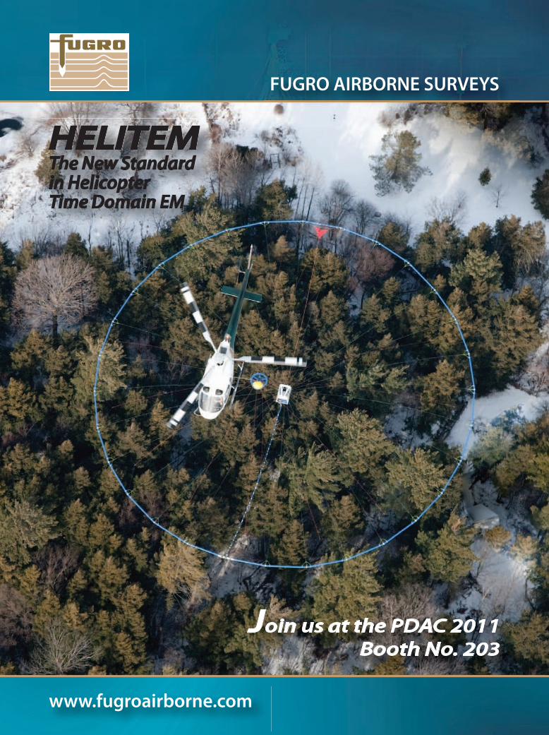
Fugro Airborne Surveys, headquartered in Ottawa, offers airborne time-domain and frequency domain electromagnetics, magnetics and magnetic gradiometry, gamma-ray spectrometry, gravity and gravity gradiometry. Survey services offered globally include data collection, data processing and interpretation. Since April 1st, 2010, the FALCON Airborne Gravity Gradiometer (AGG) technology (offered exclusively through Fugro Airborne Surveys) became available to the mineral exploration industry in addition to the petroleum industry. FALCON was specifically designed for airborne surveys and measures the differential cur-vature gradients which are used to derive the full gravity tensor and vertical gravity. A new time-domain helicopter EM system, HELITEM, was launched, offering a transmitter dipole moment of 2,000,000 Am2. In addition, Fugro ICS (the company’s Ottawa-based Interpretation & Consulting Services) began incorporating the Fugro LCT gravity and magnetic processing and modelling software into their interpretation toolbox for all geophysical da-tasets, whether from Fugro or other companies.
Geoserve Logging and Tomography (Markham, Ont.) part-nered with Toronto’s Caracle Creek International Consultants (CCIC) to deliver integrated surface and borehole IP surveys using their new EarthProbe DCIP technology. For rapid imaging of the subsurface, EarthProbe operates in four configurations: surface IP, borehole profiling, borehole-to-borehole tomography, and surface-to-borehole tomography. Originally tested in VMS environments, in 2010 CCIC applied EarthProbe to gold exploration, successfully
imaging narrow vein gold deposits in mining camps including Ontario’s Red Lake, Sudbury and Dryden. EarthProbe can provide high-resolution (4– to 16-metre electrode spacing) images to 400 metres depth, detect conductive/chargeable bodies in the vicin-ity of a borehole at a distance up 100 metres and image between boreholes up to 200 metres apart. To help with understanding the source and controls on the IP signature, CCIC provides 2-D and 3-D inversion of the data using proprietary methods and inte-grated geochemical/geophysical interpretation of bulk resistivity/
We can help you find a mineQUALITY INNOVATION EFFICIENCY SAFETY
Worldwide Services Ground BoreholeTime-domain electromagneticsInfiniTEM - deep TEMFrequency-domain electromagneticsResistivity / Induced PolarizationGravity / GPSMagneticsGamma-ray spectrometryBorehole loggingInterpretation
R
www.ageophysics.com+1.819.874.8800
Zn
Cu Ni
Au
Ag
Cr
Geoserve EarthProbe DCIP technology Credit: Geoserve Logging and Tomography

EXPLORATION TRENDS & DEVELOPMENT IN 2010
6 Supplement to The Northern Miner Vol. 97, No. 1, February 21, 2011
chargeability characteristics of mineralized and non-mineralized lithologies and alteration zones.
In October, Toronto-based Geosoft announced its plans to deliver earth modelling solutions to the exploration community by releasing new 3-D inversion modelling technology in 2011. The new earth modelling capabilities will be available as an on-line service that is accessible within Geosoft’s Oasis montaj earth mapping platform. Accessible to all geoscientists, this should contribute to improved 3-D understanding of the sub-surface.
Geotech Ltd. of Aurora, Ont., reported that 2010 proved to be very successful and marked a great return to exploration activity. The company attributed a number of new exploration successes to its new technological developments, which also made it pos-sible to flourish in the new economic environment. As a result, new personnel were added and new offices were opened. Geo-tech offices are located in Canada, Mexico City, Rio de Janeiro and Santiago (opening 2011) and Geotech Airborne Ltd. offices can be found in Perth; St. Michael, Barbados; Accra, Ghana; Jo-hannesburg and a new location Dubai.
GeoTechnologies is a Russian company based in Moscow, spe-cializing in manufacturing geophysical equipment. The company, which is not yet well known outside Russia, has developed new heli-borne combined time-domain EM and magnetic survey technology named EQUATOR which was flown on its initial surveys in 2010.
Oshawa, Ont.-based Impulse Geophysical Surveys specializes in hardware and methodology to support innovative ground and airborne EM exploration technologies. The company mandate includes exploration for new deposits, delineation of geological structures and engineering geophysics. Airborne surveys include integrated magnetic, spectrometric and electromagnetic methods. Ground surveys include deep EM methods using TEM, MTEM (multi-delivery TEM) and CSEM (controlled source EM). Appli-cations range from exploration for polymetallic ores to diamonds and hydrocarbons. In addition to surveys, the company plans to make new equipment and software commercially available.
KASI Aviation Services is a new division of KalusAir Ser-vices (Dorval, Que.) which has been in business since 1985. KASI Aviation was started in 2008 with one PA31 Navajo aircraft to supply airborne services to geophysical survey companies. The company now has three PA31 Navajos equipped for magnetom-eters, including horizontal gradient, radiometric, VLF and gravi-meters. Aircraft are equipped with long-range fuel tanks, global tracking systems and are very magnetically clean. Over 250,000
line-km had been flown by the end of October 2010 in Quebec and northern Canada. Flight crew staff were increased to accom-modate airborne geophysical companies like Tundra, Geophys-ics GPR and Terraquest which have used KASI on many sur-veys including for the Geological Survey of Canada and Quebec’s Ministère des Ressources Naturelles et de la Faune (MRNF).
For Pico Envirotec Inc. (PEI) of Concord, Ont., 2010 was a year of completion of a number of developments related to large projects in the natural resources market. Orders for turnkey in-tegrated airborne systems were delivered to India, the United States, China, Pakistan and Egypt. PEI continued with the devel-opment of instrumentation for new automated airborne survey systems. The newly developed AGRS Gamma-ray Spectrometer was thoroughly tested and a number were delivered. New com-bined instrumentation was integrated under the new name IM-PAC, simplifying and reducing wiring and increasing reliability. In partnership with T.H.E.M. Geophysics of Gatineau, Que., PEI also completed and delivered a new high-sensitivity P-THEM Helicopter-borne Time Domain EM System.
Ottawa-based Sander Geophysics (SGL) carries out airborne gravity, magnetic, electromagnetic and radiometric surveys world-wide using fixed-wing aircraft and helicopters. The company spe-cializes in high-resolution airborne surveys for petroleum and min-eral exploration, and environmental mapping. SGL reported anoth-er successful year flying numerous combined gravity and magnetic surveys, as well as combined magnetic and radiometric surveys. The majority of SGL’s surveys in 2010 were airborne gravity, includ-ing several large combined airborne gravity and magnetic surveys for petroleum exploration. Airborne gravity for mineral exploration saw SGL fly a helicopter gravity and magnetic survey for Darnley Bay Resources over the Darnley Bay gravity anomaly in the North-west Territories. In the summer of 2010, Sander Geophysics took delivery of a de Havilland DHC-6 300 Twin Otter survey aircraft to support its airborne geophysical services. Formerly operated by the Geological Survey of Finland and the British Geological Survey, the aircraft came equipped with a frequency domain electromag-netic system, a stinger-mounted magnetometer, and a radiometric system. This “three in one” system has been used extensively in Europe and Africa to produce high-quality, high-resolution geo-physical data. The addition of SGL’s AIRGrav airborne gravity sys-tem will provide a unique suite of geophysical survey systems for mineral and petroleum exploration. This aircraft had been operat-ing under Finnish civil aviation registration OH-KOG and has now been transferred to SGL’s Air Operator Certificate under Canadian registration C-GSGF. The Twin Otter is especially suited to harsh environments where a twin turbine aircraft is preferable, such as offshore arctic surveys. The addition of the Twin Otter brings SGL’s fleet to a total of 16 company owned and operated survey aircraft, all modified for airborne geophysical surveys.
SkyTEM Surveys (formerly SkyTEM Aps), headquartered in Beder, Denmark, is in its seventh year providing helicopter-borne TDEM surveys worldwide. The company is now incorporated in Canada as SkyTEM Canada, with offices based in Ottawa provid-ing an operational base for logistical and backup support for North America. In addition, SkyTEM has established an operational base in Australia, and representatives in Eastern Europe and Asia.
KASI Aviation’s horizontal magnetic gradiometer system showing wing-tip pods and tail stinger Credit: KASI Aviation Services

EXPLORATION TRENDS & DEVELOPMENT IN 2010
Supplement to The Northern Miner Vol. 97, No. 1, February 21, 2011 7
AIRBORNE GEOPHYSICAL SURVEYINGI n 2010 Moscow-based Aerogeophysica (AGP) completed
300,000 line-km of airborne gravity surveys in the oil-gas province of southern Russia. Gravimetric projects which
had started in 2009 in Brazil and Central Africa were also com-pleted in co-operation with Fugro SAS (Johannesburg) using GT-1 and GT-2 gravimeters. AGP carried out 136,000 line-km of EM surveys with the EM-4H frequency domain helicopter system (integrated with other sensors) in exploration for gold, uranium and other minerals. A detailed survey for diamond ex-ploration was flown in the Arkhangelsk region with a line spac-ing of 50 metres. That survey area was flown with a new Russian time-domain EM system from GeoTechnologies called EQUA-TOR. In 2011, Aerogeophysica expects to start a large airborne gravimetric survey project in the Russian offshore shelf zones of the Northern and Eastern seas.
Aeroquest surveyed on every continent in 2010 except Antarc-tica. The company flew extensively on regional mapping projects for Geoscience Australia to establish a high-quality dataset for deter-mining the regional setting for mineral exploration. Aeroquest also completed an aquifer-mapping project for the Canadian govern-ment using an AeroTEM IV system to add to the understanding of the structure and controls of regional aquifers, which are becoming increasingly important. The AeroTEM system was chosen because of its accuracy and good depth of investigation. Aeroquest’s ultra-high-resolution fixed-wing magnetic and radiometric system saw its first full year of deployment in North and Central America, flying throughout Mexico, the U.S. and Canada. The system uses an air-craft purpose-built for safe, low (as low as 20 metres above ground level in flat terrain) and slow operation, which makes possible the ultra-high-resolution data acquisition.
In 2010, Montreal’s EON Geosciences successfully completed two very large magnetic surveys, in Nunavut (Natural Resources Canada) and over the St. Lawrence Lowlands (MRNF). The lat-ter survey required extensive complex processing to clean the abundance of cultural effects from the magnetic data.
Fugro now offers a full suite of airborne geophysical measure-ments from a single platform, the company’s MEGATEM-Twin Otter, with the ability to simultaneously record any combination of time-domain EM, FALCON AGG, magnetic, gamma ray spec-trometric and LiDAR data. The “Flying Laboratory” is suitable for regional-scale programs where limited information has been col-
Aeroquest flying a magnetic gradiometer survey in MexicoCredit: Aeroquest

EXPLORATION TRENDS & DEVELOPMENT IN 2010
8 Supplement to The Northern Miner Vol. 97, No. 1, February 21, 2011
lected. Detailed interpretation can be pro-vided by Fugro Interpretation and Consult-ing Services. The company reported that the MEGATEM system was heading to Africa to carry out regional Flying Labora-tory exploration programs. The company’s broadband GEOTEM system continued to be active in groundwater exploration in Western Canada flying for Alberta’s Min-istry of the Environment. The TEMPEST system was busy in both North America and Australia being applied to both shallow and deep targets where good resolution of subtle conductivity differences was essen-tial. This included a number of surveys in the United States and western Canada. The TEMPEST208 system completed the Phase 1 follow-up in Nigeria, as part of a regional mapping program for the Nigerian govern-ment. That data provided a complementary dataset to the regional magnetic and radio-metric data also collected by Fugro Airborne Surveys. Fugro continued to receive strong interest in the FALCON technology and four systems carried out numerous FAL-CON surveys in North America, South America, Africa and Australia during 2010.
In addition to hydrocarbon exploration sur-veys, including a large survey in New Bruns-wick, a large number of surveys were flown for mineral targets. The company was also active in South America and Africa, carry-ing out a number of airborne gravimetric, magnetic, and gamma-ray spectrometric surveys. In Canada, over 100,000 line-km of gamma-ray spectrometric data were col-lected for Natural Resources Canada in Manitoba, Saskatchewan and Alberta. A 74,000 line-km survey was also completed for Ontario’s Ministry of Northern Devel-opment and Mines.
Geo Data Solutions (GDS) of Laval, Que., maintained its operational capacity in 2010 with a mix of regional and prospect-scale surveys. Government organizations were the sponsors of regional surveys. For example, several hundred-thousand line-km of combined magnetic/radiometric surveys were flown and several thousand lake-sediment samples were collected for the MRNF of Quebec. GDS flew prospect-scale surveys for a range of commodities throughout the Americas, often in con-junction with technical partners such as
Prospectair Ltd. of Gatineau, Que. While large-scale aeromagnetic surveys remained the primary activity, the company flew an increasing number of heli-borne surveys combining magnetics, radiometrics and transient EM. For these surveys, GDS used an EM system with a compact (8-metre-diameter) transmitter that facilitated sur-veying despite challenging logistics and ter-rain. Heli-borne magnetic and radiometric surveys were most often selected for gold, uranium and rare-earth exploration.
Geophysics GPR International (GPR) of Longueuil, Que. reported the completion in early 2010 of a large fixed-wing magnetic survey which began at the end of 2009 for the MRNF. In co-operation with a survey partner, in August, GPR commenced a large fixed-wing combined magnetic and gravity survey, also for the MRNF. Al-though there was a lower level of explora-tion activity in the private sector, GPR was able to maintain staffing levels, volume of work and continue with improvements to its instrumentation. The company re-ported a successful year conducting heli-borne magnetic gradiometer, radiometric, VLF-EM and TDEM surveys. In addition, GPR announced the development of a new TDEM system which is expected to be available for surveys in early 2011.
Geotech reported that demand in-creased throughout the year for the heli-copter-borne VTEM system with more then 30 VTEM systems now in operation. The new VTEM-Max has improved sig-nal-to-noise ratios and proven detection of deep discrete anomalies. The advances which have allowed for that improved sig-nal to noise have been implemented in all of the VTEM-series technologies (VTEM, VTEM plus and VTEM max). Interest in deep exploration has fostered the in-creased use of ZTEM, (Z-axis Tipper Elec-tro Magnetic) the helicopter-borne natural field electromagnetic system developed by Geotech. One area of deep exploration is the Athabasca basin, where the ZTEM was successful in detecting targets at greater then 1.5 km depth. Eight ZTEM systems are now operational with over 200,000 line-km flown. With the success of the ZTEM technology, the company has been work-ing on the development of a fixed-wing ZTEM system, as part of a multi-param-eter geophysical platform. The ZTEM will
Fugro’s MEGATEM system or ‘Flying Laboratory’ Credit: Fugro
Geotech’s AirMt electromagnetic
systemCredit: Geotech

Supplement to The Northern Miner Vol. 97, No. 1, February 21, 2011 9
EXPLORATION TRENDS & DEVELOPMENT IN 2010
be towed behind the fixed-wing system, while on board, a variety of gravity, mag-netic and radiometric equipment provide the multi-parameter measurements. Last year saw continued testing and limited commercial surveys with the newly de-veloped AirMt (Airborne Magnetic Total field) electromagnetic system.
MPX Geophysics Ltd. (MPX), based in Markham, Ont., reported a successful 2010, its fifth year in operation. MPX of-fers high-resolution magnetic and radio-metric surveys from both fixed-wing and helicopter platforms with the use of both towed birds and fixed booms. Most of the year’s projects were flown throughout North and South America. A new office was established in Colombia, expanding the company’s presence in Latin America beyond its Mexican office that opened in 2009. A fourth airborne platform was launched, which allowed MPX to substan-tially increase its international fixed-wing magnetic gradiometer surveying capacity.
Novatem (Mont Saint-Hilaire, Que.) contracted airborne and heli-borne mag-netics, radiometrics and time-domain
electromagnetic surveys over three con-tinents in 2010. Novatem, a Canadian company, considers itself now well estab-lished in Canada, Europe and Africa.
Precision GeoSurveys, based in Van-couver, specializes in low-level airborne geophysical surveys in mountainous ter-rain. Since its inception in 2007, Precision has flown high-resolution magnetometer-spectrometer surveys on more than 70 proj-ects in British Columbia, the Yukon, Alaska, Europe and Africa. Operating a combina-tion of chartered and owned helicopters, Precision has experience providing high-resolution geophysical data in mineral ex-ploration projects for a wide variety of geo-logical settings. In 2010, Precision increased its capabilities by adding a VLF-EM receiver and flew more than 30,000 line-km, mostly in the Yukon mountains, to support gold exploration projects.
Prospectors, based in Brazil, continued its rapid growth after doubling revenues in 2009 despite the downturn in the indus-try. This was in part because the company continued to survey for the Geological Survey of Brazil in co-operation with the
Assembling the SkyTEM TDEM transmitter loop in GreenlandCredit: SkyTEM
MPX Geophysics flying a helicopter mag and
radiometric survey in Bolivia Credit: MPX Geophysics

EXPLORATION TRENDS & DEVELOPMENT IN 2010
10 Supplement to The Northern Miner Vol. 97, No. 1, February 21, 2011
State Geological Surveys of Minas Gerais, Bahia and Goias. A Grand Caravan was added to its fleet of aircraft and activities were expanded into Argentina and Colom-bia. The company completed a number of airborne gravity surveys with additional surveys planned for 2011.
Sander Geophysics was busy flying airborne gravity surveys for petroleum and mineral exploration clients, as well as government agencies in 2010. AIRGrav surveys were flown in North America, South America, Greenland, Australasia, Asia and Antarctica with fixed-wing air-craft and helicopters. For the majority of surveys, airborne magnetic data were recorded simultaneously with the grav-ity data. The company flew several large combined airborne gravity and magnetic surveys for petroleum exploration us-ing Sander Geophysics’ unique AIRGrav technology. Numerous smaller gravity and magnetic surveys were flown, including several for mineral exploration. Helicop-ter magnetic and radiometric surveys for mineral exploration were also flown. SGL again participated in NASA’s ICE Bridge project in Antarctica and Greenland. The company now has 12 AIRGrav systems operating worldwide. SGL was selected to fly a helicopter gravity and magnetic survey for Darnley Bay Resources over the unique Darnley Bay gravity anomaly located near Paulatuk, N.W.T. The main gravity anomaly is over 130 mGals, mak-ing it the largest in North America but the source of the anomaly is unknown. The helicopter AIRGrav survey will help re-solve the subtle anomalies within the main gravity anomaly, and thereby improve the geologic model of the structure. A total of 22 drill targets were selected based on the AIRGrav survey (see www.darnleybay.com). SGL continues to offer scanning Li-
DAR surveys in conjunction with gravity and magnetics. The LiDAR system allows SGL to produce extremely high-resolution digital terrain models that can be used for gravity terrain corrections, environmental mapping, cultural editing of geophysical data, and geotechnical mapping.
In 2010 SkyTEM was contracted to fly combined TDEM/magnetic surveys in Australia, Denmark, Finland, Germany, Greenland, Spain, the U.S. and on Mayotte Island. SkyTEM reports the company was less affected by the slow economy due to a strong component of business being envi-ronmental and aquifer mapping. However, the company reported an increasing shift away from their traditional markets toward mineral exploration and government sur-veys in 2010. In July, the United States Geo-logical Survey (USGS) invited SkyTEM to fly a test area of the Ogallala Aquifer in Ne-braska. In an effort to determine the most effective method for mapping aquifers, the USGS compared SkyTEM data to data col-lected by three other airborne EM firms over the same test area. The SkyTEM meth-od was the technology selected for more thorough investigations and to fly more ex-tensive areas of the aquifer.
In its 26th year of operation, Terraquest of Markham, Ont., reported the company has now carried out fixed-wing geophysi-cal surveys in 21 countries on five conti-nents. Terraquest had a busy year operat-ing with a complement of two King Airs, one Cessna Caravan 208, two Navajos, and one Cessna 206, all equipped with hori-zontal magnetic gradiometers, radiomet-rics and the company’s proprietary XDS/VLF-EM. Terraquest flew a large horizon-tal magnetic gradient, radiometric, XDS/VLF-EM survey in the Canadian Arctic and a number of other surveys in South America, Africa, Europe and Greenland.
The company added a new DAARC 500 data acquisition system by RMS, as well as two new RSI (Radiation Solutions Inc.) crystal packs for its gamma-ray spectro-metric survey operations. In the summer, Terraquest added a helicopter-mounted stinger, equipped with a magnetometer, XDS-VLF/EM and video camera and a 20.8-litre crystal pack, which is mounted in the luggage compartment. The heli-stinger system has been operating steadily throughout Ontario in support of pros-pect-sized gold exploration projects.
Tundra Airborne Surveys of Toronto completed outfitting a Diamond DA42 Twin Star aircraft for horizontal magnetic gradient and VLF-EM surveys in 2010. The Twin Star is a state-of-the-art, all-composite aircraft with twin diesel engines and a glass cockpit. It has a large wingspan and with the extended pods, the wing-tip magnetometers are 16.2 metres apart. The aircraft is extremely fuel-efficient, can fly low and slow, and is capable of survey sor-ties as long as 6 hours. Survey speeds can be as low as 90 kts or 50 metres per sec-ond. The slow survey speed, low altitude, and large magnetometer separation allows for very high-resolution horizontal mag-netic gradient surveys. Tundra continues to provide combined magnetic horizon-tal gradient, radiometric, and VLF-EM surveys using leased Navajo aircraft from KASI Aviation Services of Dorval, Que.
Xcalibur, based in South Africa, pro-vides ultra-low-altitude surveys with years of experience in the operation of the Airtractor fixed-wing system. The Airtractor can collect data for low-level surveys (10 to 40 metres above the ground) or for any standard regional airborne sur-vey. Lower levels are particularly useful for collecting detailed radiometric and magnetic data suitable for environmen-
Tundra's recently configured DA42 Twin Star with wing-tip pods for mag gradient surveys Credit: Tundra Airborne Surveys

EXPLORATION TRENDS & DEVELOPMENT IN 2010
Supplement to The Northern Miner Vol. 97, No. 1, February 21, 2011 11
tal, groundwater, brownfields explora-tion, engineering and UXO applications. In a recent interesting example, Xcalibur helped the South African National Mu-seum find the remains of the Meermim, a slave ship stranded in the 18th century off the Cape. The results of the survey more than tripled the number of targets compared to those previously detected by the museum. Xcalibur was also successful in obtaining a contract to conduct a coun-trywide, wide-line-spacing, magnetic and radiometric survey for the Botswana gov-ernment. The survey, which is in progress, will be used to level and merge all the his-torical survey blocks acquired by the Bo-tswana Geological Survey.
Airborne Data Acquisition and ProcessingIn 2010, Condor Consulting of Lake-wood, Colo., introduced two new process-ing services: VariZ and CW-2D_Occam. VariZ is a form of constrained 3-D inver-sion that allows for the use of a predefined surface to be applied to the inversion model. A number of commercial projects using VariZ have been undertaken in the past year in the Athabasca basin, including a project for the Saskatchewan Geological Survey. CW-2D_Occam is an Occam-style 2-D inversion code for the processing of Geotech’s ZTEM-style AFMAG data that includes topographic effects. As part of the development of CW-2D_Occam, Condor carried out a series of case studies involv-ing projects where ZTEM and other air-borne or ground geophysical data had been acquired. The results of several of these studies are available on Condor’s website. Condor’s work on ZTEM was done in col-laboration with Electromagnetic Imaging Technology based in Perth, Australia.
Pico Envirotec’s engineers finished the development of IMPAC, (described during development last year as the AGIS-2010) an integrated “single-console” airborne system, which combines all of the features of PEI’s AGIS-XP, MMS-4, GPS pilot guidance and PDS-3 into a single 19-inch rack-mountable console. IMPAC is a real-time data acquisi-tion, compensated high-sensitivity magne-tometer and navigation system designed for airborne geophysical exploration and environmental science applications. Some key features are: processing for four mag-netometer sensors; 0.2 pT resolution; six
user-selectable sampling rates from 5 to 100 Hz, with six bandwidths from 0.7 to 14 Hz; real-time or post-survey magnetic compen-sation of pitch, roll, yaw and heading effects - total fields and gradients; embedded GPS navigation with both 2-D and 3-D naviga-tion for pilots; real-time flight-path imaging via an integrated USB colour digital camera; GPS synchronization at 1 pulse per second; communication with additional sensors/units via standard RS-232, and high-speed LAN (Ethernet) or USB serial interfaces. The system also has a VGA TFT daylight-readable LCD display/keyboard assembly with data recorded directly to a solid-state memory card and USB drives for system updates and data transfer.
Geosoft released two new software packages in 2010: CET Grid Analysis and geophysical Exploration Information Man-agement Solution (EIMS). The algorithms behind CET Grid Analysis were created by the Geophysics and Image Analysis Group of the University of Western Australia’s (UWA) Centre for Exploration Targeting (CET). Commercialization of the CET grid analysis tools is a joint initiative of the UWA and Geosoft, supported by Barrick Gold. Designed for mineral exploration geophysicists and geologists looking for discontinuities within magnetic and grav-ity data, it is being marketed and distribut-ed by Geosoft as a new Oasis montaj plus-third-party extension. CET Grid Analysis creates a first-pass unbiased view of the da-ta and improves the speed of interpretation
of large volumes of gridded data. CET Grid Analysis has a step-by-step trend detection menu that offers texture analysis-based image enhancement, suitable for analyz-ing regions of subdued magnetic or grav-ity responses where texture analysis can first enhance the local data contrast. It also provides discontinuity structure detection, useful in identifying linear discontinuities and in edge detection.
EIMS combines Geosoft professional services with its DAP Server technology, which is designed to store and serve large geophysical and exploration datasets. EIMS makes it possible to organize geo-physical data within a server environment that automatically deals with things like validation, QA and metadata entry for data management, and re-projection of data. Once all the data are validated and organized within a central repository, global access to the database is provided through a “Seeker” search tool. Because mining companies use digital exploration data generated over years of active explo-ration, it is important to optimize how datasets are found and utilized by explo-ration project teams. Finding, reformat-ting and importing the large airborne and ground geophysical survey databases and grids, to make them useful for projects, of-ten involves multiple steps and consumes time. Geophysical data management us-ing Geosoft’s geophysical EIMS signifi-cantly improves the way data are stored, searched and retrieved.
MAPPING STRUCTURE? ASK US ABOUT OUR PROPRIETARY XDS VLF-EM!
Horizontal Gradient Magnetics
Digital Radiometrics
In-House Processing
XDS VLF-EM

EXPLORATION TRENDS & DEVELOPMENT IN 2010
12 Supplement to The Northern Miner Vol. 97, No. 1, February 21, 2011
Geotech’s in-house Interpretation Ser-vices group now offers a complete suite of data processing, interpretation products and services to support its VTEM electromag-netic, ZTEM, aeromagnetic-gradiometric and spectrometric data acquisition surveys. Services include full 3-D solution of VTEM and ZTEM, including comprehensive 2-D to 3-D magnetic modelling and inversion using Modelvision and GM-SYS platforms, as well as full-suite derivative potential field analyses in Oasis montaj Magmap.
Pico Envirotec completed the develop-ment of an automated advanced real-time magnetic compensation and FOM calcu-lation software suite in 2010. It generates compensation coefficients in-flight and allows them to be loaded and used in real time in the AGIS and IMPAC consoles.
In 2010, Pitney Bowes Business In-sight (Troy, N.Y.) announced the release of new versions of geophysical/GIS soft-ware, Encom Discover v12.0 and Encom Discover 3D v6.0 which are now bun-dled into a single installer, simplifying installation. New features in Discover v12.0 include: for large and multi-file gridding, a tool that now provides algo-rithms for inverse distance weighting, density, distance and minimum curva-ture, and customizable options for each; a new dialog which simplifies section and plan definition; automatic regenera-tion of sections and plans, incorporat-ing any new drill holes/extensions not present when the section was originally created; automatic generation and print-ing of multiple map sheets covering a region using a new MapShop module; new temporal grouping options for in-teractive gridding, export of drill holes as DXF vectors, and batch image pro-cessing and re-projection. New features and improvements in Discover 3D v6.0 include: ability to migrate 2-D trenches and costeans data into 3-D, including the visualization of face/chip/wall sampling data; a new Seismic Section tool which allows the visualisation and interpreta-tion of SEGY seismic time and depth profiles; ability to interactively pick reg-istration points directly from raster im-agery, including internal control points; auto-saving of 3-D sessions, and gridline rendering on the cursor plane.
A new remote connectivity tool from
RMS Instruments of Mississauga, Ont., allows users full control and operation of (D)AARC500 systems from a remote Windows-based computer, across an In-ternet protocol network. The user interface of the system is seamlessly replicated in the Windows-based machine. The mouse and keyboard attached to the computer have the same effect as if they were directly con-nected to the unit. This technology facili-tates flexible architectures for complex sys-tems that incorporate the (D)AARC500. A single computer/laptop can be used to control and operate the (D)AARC500 and other instruments (e.g., gamma-ray spectrometer, gravity system, etc.). Other Windows applications can also be running
simultaneously. This remote connectivity is also very useful for training and remote support purposes. In other developments, Geosoft has now incorporated support for direct importing of DAARC500 data files in their recent release of Oasis montaj (7.2). This offers a convenient alternative to the data exporting software supplied with RMS Instruments’ systems.
SGL further refined its GPS processing software and has also developed new pro-cessing techniques for gravity data which use the horizontal components of the grav-ity field. Both developments have led to higher resolution and better accuracy grav-ity data from AIRGrav surveys. The year saw the completion of several interpretation
Condor’s results of processing Spectrem AEM data and ZTEM over the Pebble porphyry copper-gold deposit in Alaska Credit: Condor Consulting
Underlying mag structures from Geosoft’s unconstrained inversion of a mag datasetCredit: Geosoft
RMS Instruments’ DAARC500 Data acquisition system and adaptive aeromagnetic real-time compensator Credit: RMS Instruments

EXPLORATION TRENDS & DEVELOPMENT IN 2010
Supplement to The Northern Miner Vol. 97, No. 1, February 21, 2011 13
projects, including a large integrated inter-pretation project involving all available data. The primary dataset was a gravity and mag-netic survey previously acquired by Sander Geophysics, and other available data were used to constrain the interpretation. Data included land and marine seismic data, land and marine gravity data, and pre-existing airborne magnetic data, as well as available geologic maps and borehole data. Data in-terpretation was performed using in-house SGL software, as well as commercial 2-D, 2.5-D and 3-D modelling software.
The SkyTEM method claims to close the gap between ground and conventional airborne EM as it is designed specifically to provide detail and resolution compara-ble to data collected by some ground EM methods. The patented dual-moment transmitter combined with the patented SkyTEM receiver (which is null-coupled to eliminate noise from the primary field) improves discrimination of subtle chang-es in resistivity while maximizing depth of exploration. These unique characteris-tics make SkyTEM data clean and robust enough to process inversions within 24 hours of data acquisition. The delivery of advanced products in the field in 2010 was reportedly of great benefit to explora-tion managers because they could review data quickly and decide on infill lines or modified line spacing, while the SkyTEM system and crew were still onsite. A pre-survey modelling service is also offered
so that the instrumentation parameters can be customized for various targets and survey objectives.
Aeromagnetic SurveyingGEM Systems of Markham, Ont., is now offering a fixed-wing system using their Potassium GSMP-35A sensor. The GSMP-35A magnetometer is the core of the technology based on an optically pumped potassium sensor which provides an order of magnitude increase of resolu-tion over other optically pumped systems. Along with decreased maintenance costs, the company claims it also eliminates heading errors and provides the highest absolute accuracy. The technical char-acteristics of the Potassium GSMP-35A sensor are: Sensitivity: 0.0025 nT @ 1 Hz, Resolution: 0.0001 nT, Absolute Accu-racy: +/- 0.1 nT, Range: 20,000 to 120,000 nT, Gradient Tolerance: 35,000 nT/m, and sampling rates of: 1, 5, 10 and 20 Hz.
GEM Systems also offers the new Air-borne Ultra-Compact Integrated Com-pensation System, which comes with the GSMP-35A as a package. It includes: a real-time automatic aeromagnetic com-pensator, data acquisition, navigation, and a system controller.
The real-time automatic compensator has some unique and novel features. In addition to using the standard and well-known compensation terms, new terms are used to model geometric parameters
that enable compensation to be solved without applying filters to the raw data, thereby avoiding distortion of the data. This yields an accurate determination of both system heading effects and effects of high-frequency variations caused by aircraft ma-noeuvres. The result is robust over a wide range of frequencies. Solution parameters are configurable and suitable for interfac-ing to a wide range of equipment. Linear and angular accelerations are also applied for better results in the high-frequency terms. Current research is aimed at im-proving the application of these terms. The compensator is integrated with the naviga-tion and data acquisition systems providing simple “boot and go” performance.
RMS Instruments reported a busy 2010 with the deployment of new sys-tems, and the implementation of new enhancements for instruments in the (D)AARC500 family. The AARC510 ad-vanced, adaptive real-time compensation system described as ”upcoming” in last year’s review, has now been introduced. The firmware in the AARC510 is especial-ly tailored to allow unmanned operation. All instruments in the (D)AARC500 fam-ily of RMS Instruments now support four front-end-sampled analog inputs, which are in addition to the standard analog in-puts (16 differential, or 32 single-ended channels) supported through the Analog Input Module. These inputs are sampled at the same rate (up to 1280 Hz), and pro-
portable, mobile & airborne geophysical instruments & turnkey integrated systems for oil & gas and mining exploration
Pico Envirotec Inc., 222 Snidercroft Road, Concord, Ontario, Canada L4K 2K1 Tel: 1 (905) 760-9512, Fax: 1 (905) 760-9513, E-mail: [email protected]
www.picoenvirotec.com

See the difference.

See the difference.
For over three years we’ve worked side by side as Aeroquest Surveys and UTS Aeroquest. Now, united as Aeroquest Airborne, we can bring you even better service. Together, we’re the perfect fit to bring you integrated, global surveying capabilities. We offer the best available technology, worldwide, for acquiring and interpreting airborne geophysical data.
With fixed wing and helicopter-borne magnetic, gravity, radiometrics, frequency domain, time domain EM systems and the most transparent processes and data in the industry – we have everything you need to get you closer to your goal.
Aeroquest Airborne, the new name in airborne geophysical surveys.
Visit us online at aeroquestairborne.com.
Advanced Airborne Geophysics
A I R B O R N E

EXPLORATION TRENDS & DEVELOPMENT IN 2010
16 Supplement to The Northern Miner Vol. 97, No. 1, February 21, 2011
cessed in the same manner as all other magnetics signals. For basic magnetics-only surveys, an AARC500/510 equipped with this option, and an embedded GPS receiver, can provide real-time compensa-tion of up to four total fields and three gra-dients without additional data acquisition equipment. In the first quarter of 2011, RMS will introduce its new data acquisi-tion system, the DAS500 based on the state-of-the-art hardware and firmware architecture of the DAARC500 family. It will offer internal magnetometer counters for up to eight sensors, flexible and com-prehensive data acquisition and record-ing capabilities, and an embedded GPS receiver (Novatel’s OEMV-series). The system supports 16 differential or 32 sin-gle-ended analog inputs, data I/O through eight isolated serial (RS232) ports, and 100/1000 Mbps Ethernet. Data may be recorded in internal (solid-state) Flash memory, an internal hard disk, or any device with a standard USB interface. It will be suited to airborne and mobile geo-physical and environmental survey and monitoring applications.
SGL offers magnetic surveys with fixed-wing aircraft and helicopters. Heli-copter surveys can be flown with either a stinger-mounted magnetometer or a bird-mounted magnetometer, depending on the application. Fixed-wing surveys can be flown with a single tail-mounted mag-netometer, a horizontal gradient configu-ration with wingtip magnetometers, or a tri-axial gradient (horizontal, vertical and longitudinal) configuration with wingtip magnetometers and vertically separated tail-mounted magnetometers. A number of magnetic surveys were flown in 2010,
mostly in combination with other tech-niques, including gravity, radiometrics and scanning LiDAR.
During the past year, SUPRACON AG of Jena, Germany, manufacturer of both Low Temperature (LTc) and High Temperature (HTc) SQUIDs, in conjunc-tion with Institute for Photonic Tech-nologies (IPHT), also in Jena, improved the sensitivity and performance of their airborne LTc SQUID-based full-tensor magnetic gradiometer system. The ultra-high-sensitivity device known by its syn-onym “JESSY STAR,” comprises six gradi-ometers and three oriented magnetic field sensors, a differential GPS and an INU. During survey, at every measuring posi-tion, JESSY STAR continuously measures the gradients and curvature of the mag-netic fields simultaneously and provides detailed 3-D information on the distribu-tion of magnetic targets around the sen-sor. During the past 18 months, activity focused primarily on the adaptation of SQUID technology to exploration for new energy resources, including oil and gas, coal seam gas, coal and geothermal reser-voirs. A comparison of this sensor’s mea-surement to a conventional non-oriented measurement from a total magnetic field sensor shows that in spite of taking fewer measurements it is now possible to obtain a detailed 3-D understanding of the mag-netic property distribution beneath the ground or water surface. This provides the possibility to detect and accurately locate small targets situated between flight lines.
Airborne Electromagnetic SurveyingAerodat Corp. now offers three models of its time-domain EM systems: the Atem
300 (3 by 3 metre bird) for penetration to 300 metres depth; the Atem 800 (8 by 8 metre bird) for penetration to 600 metres depth; and the Atem 1500 (15 by 15 me-tre bird) for penetration to 1,500 metres depth, suitable for both mineral and hy-drocarbon exploration. (This latter system is under construction.)
The Atem 800 system is based on what is referred to as a wing, 8 metres by 8 metres in diameter with eight turns of aluminum transmitter wire and a peak current of 600 A. The dipole moment at 530 A is 270,000 Am2 depending on the base frequency, which is normally 75/90 Hz. At 600 A (the maximum) the dipole moment would be 307,000 Am2. The complete system is full waveform, comes with a radar altimeter, potassium magnetometer, on-time, off-time, and B-field processing software. The data are recorded in streaming format typi-cally at sample rates of 32 kHz to 72 kHz us-ing a 24-bit A/D convertor. The electronics are state-of-the-art with properly balanced pre-amplifiers on the receiver coils. Ancil-lary data (radar, GPS, magnetometer, etc.) are all stored at 10 Hz sample rate. There are two receiver coils, an X-coil and a Z-coil and a bucking coil which is used to reduce the primary field around the receiver coil. The 1,200-lb. rigid structure called Glider 1, has an approximate square geometry, is made from kevlar and fibreglass and oper-ates with very low noise levels. The sturdy state-of-the-art system is well suited for mountain work because the airframe is rig-id and aerodynamically constructed. The receiver coils are rigidly attached, which results in excellent data quality. The system disassembles into five major sections for transport on a 24-ft. trailer. The Atem 800 will be commercially available in Canada by spring-summer of 2011.
Aeroquest introduced the new Aero-TEMHD helicopter time-domain EM sys-tem in 2010. AeroTEMHD combines a new digital signal processing and acquisition sys-tem with a 20–metre-diameter transmitter loop and APU for a high-power system that delivers over 1 million NIA. The new system provides full flexibility in the definition of the wave-form, provides over three times the power of earlier systems, and delivers the full benefits of the AeroTEM system, including measurements during on-time and off-time, multiple components and streaming data.
Precision GeoSurveys flying a low-level mag-spec
survey in Alaska Credit: J. Barker

EXPLORATION TRENDS & DEVELOPMENT IN 2010
Supplement to The Northern Miner Vol. 97, No. 1, February 21, 2011 17
HELITEM is a new airborne EM system developed and offered by Fugro. With a transmitter dipole moment of 2,000,000 Am2, HELITEM is touted as the most powerful sys-tem of its kind and the only helicopter EM system worldwide offering full multi-coil measurement capability in all three axes (X,Y andZ), for a better understanding of geology and target ge-ometry. The company reported the new receiver technology of-fered with HELITEM provides very low noise measurements of the secondary field in the presence of the powerful transmitted primary field, providing excellent depth of exploration and tar-get sensitivity. Fugro enhanced its Cessna 208 Caravan mounted time-domain electromagnetic technology during 2010 to offer full TEMPEST system capability. TEMPEST208 uses a square-wave transmitter along with a broadband receiver to provide both depth of penetration and high-resolution layering discrimi-nation. Also available on the C-208 platform is the GENESIS sys-tem; a broadband resistivity mapping system designed as a rapid regional mapping and reconnaissance tool. Applications for these two systems range from large-scale mapping to regolith and pa-leochannel mapping, and identification of conductive targets of moderate and shallow depth. Currently, both TEMPEST208 and GENESIS are available in Europe, Africa and the Middle East.
EQUATOR is a GeoTechnologies development of a combined time-domain electromagnetic and magnetic helicopter-borne sur-vey technology. The system includes navigation, data acquisition and post-processing. To increase surveying efficiency and to make mountainous regions more accessible for surveying, EQUATOR was designed as a lightweight (total weight is about 300 kg), easily transportable system. To achieve a penetration depth comparable to that of modern time-domain EM systems, some unique meth-ods were used to increase EM receiver sensitivity. Proprietary al-gorithms for noise elimination and continuous monitoring of re-ceiver-transmitter geometry were also applied. EQUATOR is a full time-domain system with the first off-time channel at five micro-seconds. This makes the system highly effective in both conductive and resistive environments. A special high-precision magnetometer with a sampling frequency of 1000 Hz was developed for the system. It operates as normal even in the influence of EQUATOR’s primary field, eliminating the need for additional flights for a high-resolution magnetic survey. The first surveys with EQUATOR were completed successfully in southeast Siberia (Tyva Republic and Irkutsk region) in the summer of 2010. They were carried out by GeoTechnolo-gies together with NF VSEGEI (The Norilsk branch of All-Russian Geological Research Institute). Surveys were flown with an average speed of 100 to150 km per hour in difficult mountainous terrain where altitude above sea level varied from 1,300 metres to 2,300 me-tres along some flight lines. The survey area has very complicated geoelectric characteristics referred to as “dielectric inside dielectric.” The mean value of the apparent resistivity is 2000 ohm-m, with the highest contrasting conductivity anomalies being 400 ohm-m. In spite of this, high-quality data were obtained. Known deposits were detected, as well as several anomalies with economic potential. The resulting conductivity maps corresponded well to maps based on ground survey methods.
Novatem, continued the development of a new time-domain EM system in 2010, and a prototype of the system (Novatem I)
Fugro’s HELITEM helicopter EM system
Credit: Fugro

EXPLORATION TRENDS & DEVELOPMENT IN 2010
18 Supplement to The Northern Miner Vol. 97, No. 1, February 21, 2011
was completed. Emphasis was placed on obtaining an excellent signal-to-noise ratio. The mechanical part of the Novatem I sys-tem is constructed with composite materi-als minimizing mechanical deformation which seriously degrades signal quality of EM systems and can hide subtle targets. Initial test results confirm the benefits of the choice of materials, which had been based on theoretical models. The available acquisition rates of 30 and 90 Hz for the Americas and 25 and 75 Hz for Europe are suitable for detecting targets in any type of mineral exploration. The system will be au-tonomous and will not require an operator in the helicopter. Novatem was not trying to maximize the amplitudes of the mag-netic moment, but rather to maximize the quality of the receiver, which the company claims has a sensitivity at least 10 times higher than other systems. The Novatem I system measures all three components dBx/dt, dBy/dt and dBz/dt, valuable mea-surements for large-scale and detailed sur-
veys at very low altitude. Because the aim was to be able to detect all types of deposits, the Novatem I system measures dB/dt in both the on-time and off-time.
On the technology side of its business, SkyTEM’s R&D group is in the final test-ing phase of significant improvements to their time-domain electromagnetic sys-tem. Of particular note is the transmitter moment that is being increased to ap-proximately 500,000 NIA, which is four times higher than the standard configura-tion and involves eight turns on a 500 m2 loop. With this higher moment, it is still possible to measure bias-free data from 20 micro s. In addition, a new receiver coil technique improves the signal-to-noise ratio by a factor of 3 to 5. The company ex-pects to offer this new technology in 2011. SkyTEM is also working on doubling the transmitter current to produce 1 million NIA. A new transmitter configuration ca-pable of generating a new waveform will significantly improve horizontal and ver-
tical resolution. Also in the testing stage is a three-component magnetic gradiometer system installed on the TDEM loop.
Airborne Gamma-ray Spectrometric SurveyingTo offer quicker deployment and better calibration capabilities for radiometric surveys Goldak Airborne Surveys of Sas-katoon, Sask., acquired a set of radiometric calibration pads in 2010 and established a calibration range south of Saskatoon with the co-operation of the Geological Survey of Canada. This new range is acceptable to the GSC for calibration of gamma-ray spectrometric systems before surveying.
Medusa Systems BV, based in Gron-ingen, the Netherlands, celebrated its 10th anniversary in 2010. Medusa offers a novel hardware and software approach for air-borne gamma-ray spectrometry. Their spectrometer uses CsI crystals rather than the industry-standard NaI crystals. CsI crys-tals are more robust, non-hygroscopic and have higher detection efficiency, increasing count rates by up to a factor of 1.3. For pro-cessing of the radiometric data Medusa of-fers the software GAMMAN, which makes use of the full-spectral data rather than only the spectral peaks as in the widely used spec-tral windows method. This improves the counting statistics by approximately a factor of two. The company claims that combin-ing the CsI and full-spectral data processing allows a reduction of the required crystal volume by approximately a factor of four. The Medusa software can also be used to improve analysis of data from existing NaI detector packs. In 2010 the company did test flights with the German Geological Survey (BGR) and Terraquest to compare the Me-dusa spectrometer to the existing industry standard radiometrics used by the BGR and Terraquest. Based on the results, the BGR has decided to use the Medusa software in combination with the company’s Explora-nium GR-820. In other developments by the company, Ethernet (TCP/IP) is now supported as an interface, in addition to the existing USB and RS-232/485 support. The GAMMAN software suite was also extend-ed to include cosmic and radon corrections as well as the standard corrections for eleva-tion, temperature and pressure.
Radiation Solutions Inc. (RSI), based in Mississauga, Ont., reported that 2010
Aerodat’s Atem 800 time-domain EM system (See page 16) Credit: Aerodat Corp.
GeoTechnologies’ EQUATOR time-domain EM and magnetic system (See page 17) Credit: GeoTechologies

EXPLORATION TRENDS & DEVELOPMENT IN 2010
Supplement to The Northern Miner Vol. 97, No. 1, February 21, 2011 19
was a good year with increased sales worldwide for its airborne, car-borne and handheld gamma-ray spectrometer prod-ucts. RSI extended its product line by up-grading the RS-501 console in the RS-500 Advanced Digital Gamma-Ray Spectrom-eter to be able to record data from up to 20 detectors (80 litres of NaI crystal volume). The RS-700 Mobile Radiation Monitoring System (for light helicopter and vehicle mount) can now record from up to five detectors (20 litres of NaI crystal volume) using the new RS-705 console. RSI also extended its handheld product line with options for telescopic extensions to the scintillometers and spectrometers.
Sander Geophysics flies radiometric surveys with fixed-wing aircraft and he-licopters, and surveys are almost always flown in combination with magnetics. In 2010, a number of gamma-ray spectro-metric surveys were completed, including a helicopter magnetic and radiometric sur-vey for mineral exploration in Greenland.
Airborne Gravity SurveyingBell Geospace of Houston, Tex., pur-chased a second BT-67 in 2010. Basler Turbo Conversions of Oshkosh, Wis. rebuilds DC-3’s adding modern fuel-effi-cient turboprop engines and the latest avi-onics. The company reported the BT-67 provides an ideal vehicle for Air-FTG sur-veys with its capability for efficient mobi-
lization, long ferry distance, and slow sur-vey speed on a large, stable platform. The efficient twin-engine aircraft has the capa-bility to safely fly onshore, offshore, and transition-zone surveys. The BT-67 dem-onstrated its ferry and production capabil-ities when it completed data acquisition in Morocco in April, then ferried transatlan-tic to central Canada to complete a 12,000 line-km survey and then began survey-ing in southern Mexico in mid-June. Bell Geospace has developed a technique that allows the user to highlight geologic struc-tures that do not follow north-south and east-west directions. Geological trends do not necessarily follow the North-East-Down coordinate system typically used to map the gravity gradiometer tensor data. The new imaging method allows the interpreter to realign horizontal tensor
components around the vertical axis. Ad-ditionally, Bell Geospace has adapted the full tensor inversion algorithm developed by Flat Irons Geophysics (St. George, Utah) for determining tonnage estimates of iron ore deposits.
Micro-g Lacoste of Denver reported the company added a 100 Hz filter for the TAGS (Turnkey Airborne Gravity System) and improved the sturdiness of the instrumentation rack, to sustain 20 G shocks in all directions.
Sander Geophysics continued to par-ticipate in NASA’s multi-year ICE Bridge project in Antarctica and Greenland, sup-plying an AIRGrav airborne gravimeter in support of the project. ICE Bridge is de-signed to provide vital information about the ice sheet at the poles until the launch of ICESat II expected in 2014-15.
Sander Geophysics preparing for a heli-borne survey flight in Greenland Credit: SGL
Bell Geospace’s Basler BT-67 for Air-FTG surveys Credit: Bell Geospace

EXPLORATION TRENDS & DEVELOPMENT IN 2010
20 Supplement to The Northern Miner Vol. 97, No. 1, February 21, 2011
EXIGE has partnered with South Af-rican ground geophysics company Open Ground Resources to offer
3-D application of GPR and near surface imaging using high-resolution seismic re-fraction and electrical resistivity techniques worldwide, but with a strong focus in Africa.
Physical Rock Properties and Elemental AnalysisIn 2010, EXIGE reported that a dor-mant R&D project on non-destructive dual gamma-ray computed tomography of polyphase crystalline geomaterial had been resurrected. In addition neutron and X-ray scanning of samples were per-formed in partnership with the Nuclear
Energy Corp. of South Africa at its Pe-lindaba scanning facility north of Johan-nesburg with encouraging results.
Developed by Instrumentation GDD Inc. (GDD) of Quebec City during 2009 and first introduced in 2010, the new GDD portable Sample Core IP Tester (SCIP) mea-sures the electrical properties of drill cores, hand samples and outcrops. The SCIP com-bines a low power transmitter with a single channel, 20 window, time-domain receiver. The waterproof probe is suitable for use in a core shack or in the field. Measurements of resistivity and IP on DDH (diamond drill-hole) core with the portable battery-oper-ated survey instrument, provides informa-tion needed to design the most appropriate
GROUND SURVEY TECHNIQUES
EMpulse’s SFERIC II System: Field setup for AMT measurement
(see page 22) Credit: EMpulse Geophysics
Instrumentation GDD’s SCIP sample core IP tester Credit: Instrumentation GDD

EXPLORATION TRENDS & DEVELOPMENT IN 2010
Supplement to The Northern Miner Vol. 97, No. 1, February 21, 2011 21
resistivity and IP field surveys. For example, it can be determined from initial drilling whether the IP contrast will be large enough to produce anomalies in the field. The company reported excellent feedback from users in its first year of operation.
In July 2010, Thermo Fisher Scientific (Billerica, Mass.) intro-duced its unique Thermo Scientific TestAll Geo feature for its X-ray fluorescence (XRF) analyzers. The correct analytical test mode for rapid analysis of major, minor, and trace elements in geological samples is now automatically determined by new software simpli-fying sample analysis. Previously, when users wanted to measure samples with both low and high concentrations, they had to take two measurements on the same sample, one in Soil Mode and one in Mining Mode, and then combine the results offline. Now, TestAll Geo automatically selects the right analytical approach for each ele-ment and chooses either parts per million (ppm) or weight percent as appropriate for the measured concentration. If both calibrations (low and high) contain the same element, then the mode having the lower detection limit will be displayed. For example, using TestAll Geo, a sample analysis could yield 15 ppm molybdenum and 880 ppm lead in the presence of 21% copper and 22% iron. The compa-ny also enhanced the Niton XL3t GOLDD+ XRF analyzer for min-ing and exploration. It now provides user programmable options to customize instrument output for what are called “pseudo-element” calculations. This new feature is useful for converting element con-centrations into, for example, ounce/ton, oxides, cutoff grade and gold equivalent. The Canadian distributor is Elemental Controls, based in Mississauga, Ont.
Data Processing and PositioningThe main new development at Lamontagne Geophysics (Kings-ton, Ont.) in 2010 was a 3-D EM forward solution suitable for E and H field simulation over a wide bandwidth and a fine 3-D grid. The new solution uses an iterative multigrid finite difference vector potential formulation suitable for efficient multithread-ing and vectorization. The aim is to use the new solution in ISR imaging, EM imaging and general forward modelling.
Drill-hole MethodsIn 2010, Abitibi Geophysics was authorized by Scintrex of Concord, Ont., to offer Gravilog, slim-hole gravity logging services, including data acquisition and interpretation, in North America. This diagnostic tool complements the com-pany’s electromagnetic and IP borehole exploration services. In mining applications, borehole gravity data can be used to detect massive sulphide bodies such as a VMS orebody, and es-
timate their tonnage independent of their shape, or map bulk densities of forma-tions intersected by the hole. Borehole gravity measurements collect important diagnostic information not previously available.
To complement its existing mineral deposit targeting service, EXIGE entered into a partnership with Wireline Workshop, to offer quality assurance, processing and analysis of geophysical wireline logging data in mineral exploration and mining projects. The service includes onsite supervision, project management and training, worldwide.
JVX Ltd. of Richmond Hill, Ont., is continuing its research and development of a borehole Spectral Induced Polarization System. The JVX Borehole system now has the capability of imaging be-tween boreholes that are separated by up to 300 metres. The cross-hole capability is an add-on feature of the JVX borehole system. The system, which has been deployed in mine sites in Canada and internationally, has been used primarily to map gold-bearing orebodies, and to guide drilling.
Scintrex is working with Abitibi Geophysics to provide bore-hole gravity surveys to the mining industry in Canada and the U.S. During 2010, Scintrex’s Gravilog borehole gravity meter was used to log boreholes in Canada, the U.S. and Brazil. Due to the in-terest in borehole gravity, Scintrex is building additional Gravilog systems for deployment in early 2011.
Ground Electromagnetic MethodsUsing its InfiniTEM II loop Abitibi Geophysics, mapped the Lalor deposit of HudBay Minerals, where it is about 1,200 metres deep
Borehole TDEM survey by Abitibi Geophysics in Saskatchewan’s Athabasca basin Credit: Abitibi Geophysics
Screen shot showing Thermo
Scientific’s TestAll Geo
feature for its XRF analyzer
Credit: Thermo Scientific

EXPLORATION TRENDS & DEVELOPMENT IN 2010
22 Supplement to The Northern Miner Vol. 97, No. 1, February 21, 2011
New for 2011!
Condor Consulting, Inc.Condor focuses on all aspects of airborne geophysics as it relates to the search for min-eral resources. In 2011, Condor has added the ability to provide commercial processing and analysis of ZTEM Afmag data. Given the newness of the ZTEM technique, Condor has generated a series of case studies and a tutorial on ZTEM (ZTEM Primer) so as to aid our clients in the best use of this exciting technique.
Contact us for details!
2201 Kipling Street, Suite 150, Lakewood Colorado 80215 • Tel: 303-423-8475 • Fax:303-423-9729
www.condorconsult.com
ZTEM
using a 40,000,000 Am2 dipole moment en-ergizing field. A B-field fluxgate sensor re-corded on-time and off-time full-wave data at picotesla sensitivity for all three compo-nents (X, Y and Z). (The large size of the orebody contributed to its easy detection.) The fluxgate sensor, which proved to be re-liable in the field in temperatures down to -40 degrees C, was logistically easy to man-age, and minimally affected by external noise sources such as wind. To generate the high dipole moment fields required for in-creased depth of penetration, Abitibi Geo-physics upgraded its InfiniTEM II systems to use the TerraScope Instruments por-table generator with an 18-kW transmitter.
In an innovative development, Alpha Geoscience (Peakhurst, Australia) re-vamped the configuration of the terraTEM transient EM system in 2010, by placing the touchscreen display on the main unit – pre-viously the screen was on the case lid. This has made operating the unit in the field quicker and easier for surveys and data ac-quisition. The company has also enhanced the light and compact terraTX-50 external transmitter for the terraTEM transient EM system with GPS synchronization. The ex-ternal transmitter complements the terra-TEM’s internal transmitter.
EMpulse Geophysics of Dalmeny, Sask., has extended the bandwidth of its SFERIC
Alpha Geoscience’s new TerraTEM transient EM system with touchscreen display on main unitCredit: Alpha Geoscience
Abitibi Geophysics conducting an
infiniTEM surveyCredit: Abitibi Geophysics

EXPLORATION TRENDS & DEVELOPMENT IN 2010
Supplement to The Northern Miner Vol. 97, No. 1, February 21, 2011 23
II Transient AMT receiver from 5 Hz down to 0.5 Hz while retaining the 32 kHz upper frequency limit. New SBM series induction coils, with a band-width of 0.5 Hz to 50 kHz and a noise floor of 1 femtoTesla/root(Hz) at 2000 Hz have been constructed for use with the extend-ed bandwidth. As well, the vertical electric field has been incorporated as a standard measurable to provide an even lower noise detection of transient events greater than 500 Hz. 2010 saw the first consistent project-scale use of the vertical electric field with the SFERIC II system. Construction of the SFERIC III re-ceiver, with bandwidth of .001 Hz to 50 kHz, is behind schedule but is expected to be completed in 2011/12. An expansion/upgrade of the compa-ny’s existing 3-D inversion cluster is planned for 2011 to have the capability of inverting as many as 400 stations simultaneously in 3-D.
In new developments during 2010 at Geonics Ltd. of Missis-sauga, Ont., the company increased the power capabilities of its highest power transmitter, the TEM67Plus, by synchronizing two units so that the total maximum output voltage was increased to 480 V at 28 A current. This allows for use of a larger loop with the maximum current. In addition, the output current capabilities of the battery-operated transmitter, the TEM47, has been increased to a maximum current of 10 A.
After the first series of deliveries of the multi-depth conduc-tivity meter “CMD-Explorer” introduced in 2009, GF Instru-ments (Brno, Czech Republic) developed and commercialized the new “CMD-Mini Explorer” in 2010 with simultaneous 0.5, 1.0, 1.8-metre depth ranges for three-depth shallow surveys. This
lightweight and easily operated instrument meets the requirements for agriculture, archaeol-
ogy, road inspection and network detection where its capability of in situ EM inversion
with 2-layer model parameters is es-pecially useful. Due to the long-term calibration and temperature stability,
up to 10 Hz sampling rate, and GPS compatibility, the CMD-Mini Explorer
can be used for both walking and mobile applications, rapidly performing layered conductivity mapping of large areas.
The UTEM 5 surface EM system will be introduced by Lamontagne Geophys-ics commercially for the first time in the summer of 2011 after field testing during the winter. The main characteristics of the new system are simultaneous multi-axis multi-transmitter measurements with an
order of magnitude improvement in measurement accuracy. The system is designed for routine operation down to the 2 Hz base frequency and detailed survey capability well below 1 Hz.
Gravity SurveyingScintrex has successfully commercialized INO (pronounced “Eye-No”), a sea-bottom gravimeter. Scintrex’s INO, named af-ter a princess in Greek mythology, encases the well-known CG-5 Autograv in a bell that is lowered into the water from the side of a ship or barge. The equipment operator remotely controls INO from an onboard laptop computer. The pressure vessel for INO allows for gravity data to be acquired to microGal precision on the seafloor to a maximum depth of 600 metres. For greater wa-ter depths, to 5,000 metres, the pressure vessel is modified and INO may be configured for deployment using an ROV. Appli-cations of the gravimeter include exploration and evaluation of seafloor massive sulphide deposits, tectonics, ocean ridges, geo-logical mapping and general gravity mapping of the sea floor.
Induced PolarizationThe new high-sensitivity IP methodology, IPower3D, developed by Abitibi Geophysics, moved from R&D testing to its first pro-duction survey in 2010 in the Matagami mining camp, a region known for its thick, conductive overburden. IPower3D succeeded in resolving a small bedrock mineralized body under 120 metres of 80 ohm-metre overburden, confirming the R&D modelling pre-dictions. Abitibi recommends the use of IPower3D in areas with thick and/or conductive overburden. The company reported that use of the hole-to-hole H2H 3D IP methodology has increased due to the large radius of exploration. In H2H 3D IP the radius of exploration is about half the distance between two holes being surveyed simultaneously. For example, with holes up to 1,000 me-tres apart, the exploration radius of 500 metres is up to five times greater than that achievable with conventional borehole IP.
GDD Instrumentation IP Transmitters were significantly improved in 2010 with the introduction of new electronic circuit boards that increase their reliability, especially at high voltage
Scintrex’s INO sea bottom gravimeter Credit: Scintrex
Abitibi Geophysics’ IPower3D receiver
set-up in conductive overburden environment
Credit: Abitibi Geophysics
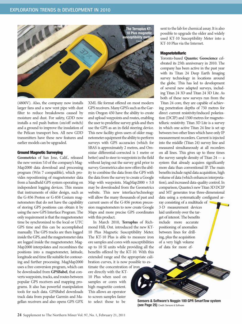
EXPLORATION TRENDS & DEVELOPMENT IN 2010
24 Supplement to The Northern Miner Vol. 97, No. 1, February 21, 2011
(4800V). Also, the company now installs larger fans and a new vent pipe with dust filter to reduce breakdowns caused by moisture and dust. For safety, GDD now installs a red push button (on/off switch) and a ground to improve the insulation of the Pelican transport box. All new GDD transmitters have these new features and earlier models can be upgraded.
Ground Magnetic SurveyingGeometrics of San Jose, Calif., released the new version 5.0 of the company’s Mag-Map2000 data download and processing program (Win 7 compatible), which pro-vides repositioning of magnetometer data from a handheld GPS system operating on independent logging devices. This means that instruments of older design, such as the G-856 Proton or G-858 Cesium mag-netometers that do not have the capability of storing GPS positions can obtain it by using the new GPS Interface Program. The only requirement is that the magnetometer time be synchronized to the local or UTC GPS time and this can be accomplished manually. The GPS tracks are then logged inside the GPS, and the magnetometer data are logged inside the magnetometer. Mag-Map2000 interpolates and recombines the positions into a magnetometer, latitude, longitude and time file suitable for contour-ing and further processing. MagMap2000 uses a free conversion program, which can be downloaded from GPSBabel, that con-verts waypoints, tracks, and routes between popular GPS receivers and mapping pro-grams. It also has powerful manipulation tools for such data. GPSBabel downloads track data from popular Garmin and Ma-gellan receivers and also opens GPS GPX
XML file format offered on most modern GPS receivers. Many GPS’s such as the Gar-min Oregon 450 have the ability to create and upload waypoints and routes, enabling the user to predefine survey grids and then use the GPS as an in-field steering device. This new facility gives users of older mag-netometer equipment the ability to perform surveys with GPS accuracies (which for SBAS is approximately 2 metres, and Om-nistar differential-corrected is 1 metre or better) and to steer to waypoints in the field without laying out the survey grid prior to survey. Geometrics also now offers the abil-ity to combine the data from the GPS with the data from the survey to create a Google Map with waypoints. MagMap2000 v 5.0 may be downloaded from the Geometrics website. This new interface/technology will allow the many thousands of past and current users of the G-856 proton preces-sion magnetometers to now create Google Maps and more precise GPS coordinates with this product.
In March 2010, Terraplus of Rich-mond Hill, Ont. introduced the new KT-10 Plus Magnetic Susceptibility Meter. The KT-10 Plus is able to measure iron ore samples and cores with susceptibilities up to 10 SI units while providing all the benefits offered by the KT-10. With this extended range and the appropriate cali-bration curves, it is now possible to es-timate the concentration of iron ore directly with the KT-10 Plus when used on samples or cores with high magnetite content. This allows an operator to screen samples faster to select those to be
sent to the lab for chemical assay. It is also possible to upgrade the older and widely used KT-10 Susceptibility Meter into a KT-10 Plus via the Internet.
MagnetotelluricToronto-based Quantec Geoscience cel-ebrated its 25th anniversary in 2010. The company has been active in the past year with its Titan 24 Deep Earth Imaging survey technology in locations around the globe. This has led to development of several new adapted surveys, includ-ing Titan 24 3D and Titan 24 3D Lite. As both of these new surveys run from the Titan 24 core, they are capable of achiev-
ing penetration depths of 750 metres for direct current resistivity/induced polariza-tion (DCIP) and 1500 metres for magneto-telluric resistivity. Titan 3D Lite is a survey in which one active Titan 24 line is set up between two other lines which have only IP measurement recorders. Current is injected into the middle (Titan 24) survey line and measured simultaneously at all recorders on all lines. This gives up to three times the survey sample density of Titan 24 — a system that already acquires significantly more data than conventional IP. The main benefits include rapid data acquisition, high volume of data (which enhances interpreta-tion), and increased data-quality control. In comparison, Quantec’s new Titan 3D DCIP and MT generates true three-dimensional data using a systematically configured ar-ray consisting of a multitude of 3-D measurement devices laid uniformly over the tar-get of interest. The benefits include more accurate positioning of anomalies between lines for drill-ing, plus the acquisition of a very high volume of data for more ef-
The Terraplus KT-10 Plus magnetic
susceptibility meterCredit: Terraplus
Sensors & Software’s Noggin 100 GPR SmartTow system (see Page 25) Credit: Sensors & Software

EXPLORATION TRENDS & DEVELOPMENT IN 2010
Supplement to The Northern Miner Vol. 97, No. 1, February 21, 2011 25
fective interpretations. Another inherent benefit is that the processing and interpreta-tion incorporates 3-D effects, which makes interpretation of complex geology much more feasible. The company reported the method was used to good advantage at Bar-rick Gold’s Gold Hill property in Nevada.
Ground Penetrating Radar (GPR)Sensors & Software Inc. of Mississauga, Ont., has manufactured Noggin GPR sys-tems since 1997. Noggins were designed to provide full GPR functionality in an easy to use “monolithic” package with flexibili-ty and simplicity. Until 2010, Noggins were only available in higher frequencies of 250, 500 and 1,000 MHz with the antennas em-bedded in the package. Lower-frequency GPR systems require larger antennas. Cre-ating a compact, low-frequency Noggin was solved with the new Noggin 100 GPR, which comes with detachable 100 MHz antennas that allow the whole system to fit into a single hand-carried shipping case. The Noggin 100 has lower power consumption and fewer heavy batteries for field surveys, allowing the SmartTow configuration to be easily transported into remote areas. The system is also readily deployed on the SmartCart in smooth ar-eas. Accessories include the large-diameter odometer wheel for equally spaced data collection and GPS for positioning. Ap-plications range from mining exploration and geotechnical investigations to deep utility detection and archaeology.
Ground Radiometric SurveyingIn 2010, GF Instruments introduced the new Gamma Surveyor II, a super-compact 1024-channel gamma-ray spectrometer for K, U and Th assays and dose rate measure-ment in field exploration, borehole logging, mobile and laboratory applications. The light weight (1.4 kg), rugged, water-sub-mersible instrument equipped with a BGO detector (20 cm3 = 1.2 in3, or 103 cm3 = 6.3 in3) uses a unique method of spec-tral processing (without a radioactive test source) allowing rapid detection and evaluation of anomalies in both Search and Assay modes. The performance with a small BGO detector is comparable to stan-dard instruments with a larger-volume NaI detector. Gamma Surveyor II provides easy operation for measurements with an
internal detector or external probe (e.g. in a borehole assembly or in collimator shielding). It has an extra-large data mem-ory, GPS compatibility, reliable long-life battery supply, and Bluetooth communica-tion with the probe, GPS or earphones. A wide choice of optional accessories allows measurements in boreholes, shallow holes, a laboratory, water and also alpha and beta radiation detection.
Resistivity SurveyingInstrumentation GDD developed the new GDD Current Indicator to improve the safety of field operators while they manipulate wires and electrodes for re-sistivity and induced-polarization sur-veys. The new IP accessory warns the operator if current is sent by the trans-mitter. The current indicator is simply connected to the transmitting electrode to measure the current injected into the ground. A LED indicates the presence of current and in addition, the operator can follow the transmission cycle. This new product should result in a significant im-provement in operator safety. Another useful application of the new accessory is detection of current leakage or damaged wires between the transmitter and the transmitting electrode. This is particu-larly useful for pole-survey configura-tions to compare the current transmitted from the transmitter to the actual current injected into the ground, so that inappro-priate or cracked wire insulation can be easily detected.
SeismicMicro-g LaCoste, which specializes in gravimetric technology, introduced the LPSTM Long Period Seismometer. Studies of ocean waves, earthquakes, volcanic and tectonic tremors, and other sources of small magnitude, low-frequency, naturally occurring ambient earth seismicity are important for un-derstanding natural hazards. Broadband seismometers using gravity-sensor tech-nology make it possible to record these long period signals. In the petroleum industry, new passive seismic methods that use naturally occurring sources also require receivers capable of accurately measuring low-frequency signals.
GF Instruments’ Gamma Surveyor II 1024-channel gamma-ray spectrometer
Credit: GF Instruments

EXPLORATION TRENDS & DEVELOPMENT IN 2010
26 Supplement to The Northern Miner Vol. 97, No. 1, February 21, 2011
A AmpereAEM AirborneEMAFMAG AudioFrequency
MagnetotelluricsAm2 AmperemetressquaredAPU AuxilliaryPowerUnitB MagneticFieldBGO BismuthGermanateCDI ConductivityDepth
ImagingCsI CesiumIodidedB/dt rateofchangeof
BwithtimeDC DirectCurrentDGPS DifferentialGPSDXF DataExchangeFormat;
for3-DAutoCADfilesEM ElectromagneticFOM FigureofMerit
fT femtoTeslaGB GigabyteGIS GeographicInformation
SystemsGPR GroundProbingRadarGPS GlobalPositioningSystemHz Hertz=cyclespersecondINS InertialNavigationSystemINU InertialNavigationUnitIP InducedPolarizationISR InductiveSourceResistivitykV kilovoltkW kilowattLAN LocalAreaNetworkLED LightEmittingDiodeLiDAR LightDetectionandRangingMbps MegabitspersecondMT MagnetotelluricNaI SodiumIodide
NASA NationalAeronauticandSpaceAdministration
NIA DipoleMomentofEMloop(N=Numberofturns,I=current,A=area)
nT nanoTeslapT picoTeslaQC/QA QualityControl/Quality
AssuranceROV RemotelyOperatedVehiclert rootSBAS SatelliteBasedAugmen-
tationSystemSEG SocietyofExploration
GeophysicistsSEGY SEGtapestandardused
forseismicdataSQUID SuperconductingQuantum
InterferenceDevice
TCP/IP TransmissionControlProtocol/InternetProtocol
TDEM TimedomainEMTEM TransientEM(=TDEM)TFT ThinFilmTransistor
(‘Active’Display)USB UniversalSerialBusUTC CoordinatedUniversalTimeUTEM UniversityofTorontoEMUXO UnexplodedOrdnanceV VoltVGA VideoGraphicsArrayVMS VolcanogenicMassive
SulphideVTEM VersatileTEMVLA VeryLightAircraftVLF VeryLowFrequencyW WattXRF X-RayFluorescence
Aerodat Corp.: www.aerodat.caAbitibi Geophysics Inc.: www.ageophysics.comAerogeophysica Inc.: www.aerogeo.ruAeroquest Airborne: www.aeroquest.caAirWatch: www.alto-air.comAlpha Geoscience Pty. Ltd.:www.alpha-geo.comAretech Group: www.AretechGroup.comBasler Turbo Conversions: www.baslerturbo.comBell Geospace Inc.:www.BellGeo.comBritish Geological Survey: www.bgs.ac.ukCanadian Exploration Geophysical Society (KEGS):www.KEGSonline.orgCanadian Micro Gravity: www.CanadianMicroGravity.comCaracle Creek International Consulting Inc.: www.caraclecreek.comCondor Consulting Inc.: www.CondorConsult.comDeveloping Technology: www.devtec.caDiaKim Consulting Ltd.: www.diakim.co.ukElemental Controls Ltd.: www.ElementalControls.comEMpulse Geophysics Ltd.: www.EMpulse.caElectromagnetic Imaging Technology: www.eletromag.com.auEON Geosciences Inc.:www.EONgeosciences.comEXIGE: www.exigesa.comFlat Irons Geophysics: Email: [email protected] Airborne Surveys: www.FugroAirborne.comGEM Systems Inc.:www.GemSys.caGeo Data Solutions Inc.: www.GeoDataSolutions.caGeological Survey of Canada:www.gsc.nrcan.gc.ca
Geological Survey of Brazil:www.cprm.gov.brGeological Survey of Finland:www.gsf.fiGeometrics: www.geometrics.comGeonics Ltd.: www.geonics.comGeophysics GPR International Inc.:www.geophysicsgpr.comGeoscience Australia: www.ga.gov.auGeoserve Logging & Tomography: www.Geo-LT.comGeosoft: www.Geosoft.comGeotech Ltd.: www.geotech.caGeoTechnologies: gp.gtcomp.ruGerman Geological Survey (BGR): www.bgr.bund.deGF Instruments:www.GFinstruments.czGoldak Airborne Surveys:www.goldak.caGPSBabel: www.gpsbabel.orgImpulse Geophysical Surveys Ltd.:[email protected] for Photonic Technology:www.IPHT-jena.deInstrumentation GDD Inc.: www.gdd.caJVX Ltd.:www.JVX.caKASI Aviation Services Inc.:www.kasiaviation.comLamontagne Geophysics Ltd:www.Lamontagnegeophysics.comMedusa Systems BV: www.medusa-online.comMicro-g LaCoste Inc.:www.microglacoste.comMinistère des Ressources Naturelle et de la Faune (MRNF): www.mrn.gouv.qc.caMinistry of Northern Development and Mines:www.mndm.gov.on.caMPX Geophysics Ltd.: www.MPXgeophysics.comNASA’s ICE Bridge project: www.espo.nasa.gov/oib
Natural Resources Canada: www.nrcan.gc.caNuclear Energy Corp. of South Africa:www.necsa.co.zaNovatem Inc.:www.novatem.comNF VSEGEI:www.nfvsegei.comOpen Ground Resources:www.openground.co.zaPico Envirotec Inc.:www.PicoEnvirotec.comPitney Bowes Business Insight:www.PBBusinessInsight.comPrecision GeoSurveys Inc.:www.precisiongeosurveys.comProspectair Ltd.: www.prospectair.caQuantec Geoscience:www.quantecgeoscience.comRadiation Solutions Inc.:www.RadiationSolutions.caRMS Instruments: www.RMSinst.comSander Geophysics:www.sgl.comScintrex Ltd.: www.scintrex.comSensors & Software Inc.: www.SenSoft.caSkyTEM Surveys: www.SkyTEM.comSpectrem Air Ltd.: www.spectrem.co.zaSupracon AG:www.supracon.comTerraplus Inc.: www.terraplus.caTerraquest Ltd:www.terraquest.caTerraScope Instruments:www.terrascope-instruments.comT.H.E.M. Geophysics Inc.: www.THEMgeo.comThermo Scientific Niton Analyzers: www.thermo.com/nitonTundra Airborne Surveys Ltd.: www.tundraair.comUnited States Geological Survey: www.usgs.govUniversity of Western Australia: www.uwa.edu.auWireline Workshop: www.wirelineworkshop.com
Companies and Websites
Abbreviations (for acronyms used in the text)
If the next big mining story of 2011 happens somewhere out
here, we’ll be there.
To subscribe call toll free 1-800-668-2374 or visit www.northernminer.com

Abbreviations (for acronyms used in the text)
If the next big mining story of 2011 happens somewhere out
here, we’ll be there.
To subscribe call toll free 1-800-668-2374 or visit www.northernminer.com