Understanding the cultural historical value of the Wadden Sea region. The co-evolution of environment and society in the Wadden Sea area in the Holocene up until early modern times (11,700 BCe1800 AD): An outline J. Bazelmans a, * , D. Meier e , A. Nieuwhof b , T. Spek c , P. Vos d a Cultural Heritage Agency, Amersfoort, The Netherlands b University of Groningen, Groningen Institute of Archaeology, The Netherlands c University of Groningen, Centre for Landscape Studies, The Netherlands d Deltares, Utrecht, The Netherlands e Küstenarchäologie Schleswig-Holstein, Wesselburen, Germany article info Article history: Available online 29 May 2012 abstract The Wadden region is a cultural landscape of exceptional cultural historical value. The present article describes in qualitative terms how the cultural landscape of the Wadden Sea region came about through the complex interaction of people and nature. Human impact on this region has occurred in stages, with changes in the way of life, technology, the organisation of labour and the use of natural and fossil fuels playing a key role. With each stage, the impact of people on the natural environment increased expo- nentially, bringing with it each time a combination of intended and unintended outcomes. Although technological or organisational innovations meant that people were sometimes successful at overcoming these effects, at other times they were not. Ó 2012 Elsevier Ltd. All rights reserved. 1. Introduction The Wadden Sea is generally regarded as a complex of ‘natural, large-scale, intertidal ecosystems where natural processes continue to function largely undisturbed’. 1 Hence the status of world heri- tage site granted to about 66% of the region on the basis of natural criteria. The larger Wadden region e an area of dyked salt marshes and reclaimed coastal peat bogs e is viewed as a cultural landscape of exceptional cultural historical value (Vollmer et al., 2001). This appraisal is supported by a recent study comparing the Wadden Sea region with 15 other coastal wetlands containing visible human adaptations to the environment in the form of embankments, dykes, canals, polders, etc. (Essex County Council, 2010). Judged by a range of criteria, 2 the Wadden Sea region has emerged as one of the highest value areas, surpassing sites like the Po delta (Italy), Mont St-Michel and its bay (France), Romney Marsh (United Kingdom), the Sundarbans (Bangladesh and India), the Thames estuary (United Kingdom) and the Camargue (France). The present article describes in qualitative terms how the cultural landscape of the Wadden Sea region came about through the complex interac- tion of people and nature (Meier, 2006, 2011, 2012). 2. The post-Pleistocene development of the Wadden Sea area When the Holocene began 11,700 years ago, the Wadden Sea region did not yet exist. The later coastal area of the northern Netherlands, Germany and southern Denmark was still part of a vast plain, the greater part of which was formed during the Pleistocene (Gaffney et al., 2007). This glacial landscape was liter- ally the foundation for the changes described in this article. It was here during the Holocene that metres-thick layers of sand and clay were deposited and extensive layers of peat were formed. 3 The rising sea level was the major driving force behind these changes. Following a rapid rise in temperature within in a short space of time 11,700 years ago, the lowlands filled with meltwaters from the northern polar ice caps over a period of 6,000 years, to roughly the level of the present-day coastline of the southern North Sea. * Corresponding author. E-mail address: [email protected](J. Bazelmans). 1 http://whc.unesco.org/en/list/1314. 2 The criteria are time depth, integrity of the cultural landscape, level of archaeological and documentary evidence, degree of adaptation of the natural environment, associative cultural significance, extent of cultural landscape, and authenticity. 3 The Holocene coastal area of Northwest Europe between Calais and Esbjerg comprises almost 40,000 km 2 . Contents lists available at SciVerse ScienceDirect Ocean & Coastal Management journal homepage: www.elsevier.com/locate/ocecoaman 0964-5691/$ e see front matter Ó 2012 Elsevier Ltd. All rights reserved. doi:10.1016/j.ocecoaman.2012.05.014 Ocean & Coastal Management 68 (2012) 114e126
Understanding the cultural historical value of the Wadden Sea region. Theco-evolution of environment and society in the Wadden Sea area in theHolocene up until early modern times (11,700 BCe1800 AD): An outline
J. Bazelmans a,*, D. Meier e, A. Nieuwhof b, T. Spek c, P. Vos d
aCultural Heritage Agency, Amersfoort, The NetherlandsbUniversity of Groningen, Groningen Institute of Archaeology, The NetherlandscUniversity of Groningen, Centre for Landscape Studies, The NetherlandsdDeltares, Utrecht, The NetherlandseKüstenarchäologie Schleswig-Holstein, Wesselburen, Germany
1 http://whc.unesco.org/en/list/1314.2 The criteria are time depth, integrity of the
archaeological and documentary evidence, degreeenvironment, associative cultural significance, extenauthenticity.
0964-5691/$ e see front matter � 2012 Elsevier Ltd.doi:10.1016/j.ocecoaman.2012.05.014
a b s t r a c t
The Wadden region is a cultural landscape of exceptional cultural historical value. The present articledescribes in qualitative terms how the cultural landscape of the Wadden Sea region came about throughthe complex interaction of people and nature. Human impact on this region has occurred in stages, withchanges in the way of life, technology, the organisation of labour and the use of natural and fossil fuelsplaying a key role. With each stage, the impact of people on the natural environment increased expo-nentially, bringing with it each time a combination of intended and unintended outcomes. Althoughtechnological or organisational innovations meant that people were sometimes successful at overcomingthese effects, at other times they were not.
� 2012 Elsevier Ltd. All rights reserved.
1. Introduction
The Wadden Sea is generally regarded as a complex of ‘natural,large-scale, intertidal ecosystemswhere natural processes continueto function largely undisturbed’.1 Hence the status of world heri-tage site granted to about 66% of the region on the basis of naturalcriteria. The larger Wadden region e an area of dyked salt marshesand reclaimed coastal peat bogs e is viewed as a cultural landscapeof exceptional cultural historical value (Vollmer et al., 2001). Thisappraisal is supported by a recent study comparing theWadden Searegion with 15 other coastal wetlands containing visible humanadaptations to the environment in the form of embankments,dykes, canals, polders, etc. (Essex County Council, 2010). Judged bya range of criteria,2 the Wadden Sea region has emerged as one ofthe highest value areas, surpassing sites like the Po delta (Italy),Mont St-Michel and its bay (France), Romney Marsh (United
J. Bazelmans).
cultural landscape, level ofof adaptation of the naturalt of cultural landscape, and
All rights reserved.
Kingdom), the Sundarbans (Bangladesh and India), the Thamesestuary (United Kingdom) and the Camargue (France). The presentarticle describes in qualitative terms how the cultural landscape ofthe Wadden Sea region came about through the complex interac-tion of people and nature (Meier, 2006, 2011, 2012).
2. The post-Pleistocene development of the Wadden Sea area
When the Holocene began 11,700 years ago, the Wadden Searegion did not yet exist. The later coastal area of the northernNetherlands, Germany and southern Denmark was still part ofa vast plain, the greater part of which was formed during thePleistocene (Gaffney et al., 2007). This glacial landscape was liter-ally the foundation for the changes described in this article. It washere during the Holocene that metres-thick layers of sand and claywere deposited and extensive layers of peat were formed.3 Therising sea level was the major driving force behind these changes.Following a rapid rise in temperaturewithin in a short space of time11,700 years ago, the lowlands filled with meltwaters from thenorthern polar ice caps over a period of 6,000 years, to roughly thelevel of the present-day coastline of the southern North Sea.
3 The Holocene coastal area of Northwest Europe between Calais and Esbjergcomprises almost 40,000 km2.
J. Bazelmans et al. / Ocean & Coastal Management 68 (2012) 114e126 115
And yet the sudden climate warming and subsequent absoluterise in sea level was only one factor that led to the drowning of thearea. This is because, with the exception of someminor fluctuationsfollowing the temperature surge, the climate did not becomesubstantially warmer after the beginning of the Holocene. Themelting of the polar ice caps of North America and Scandinavialasted several thousand years but came to a halt about 6,000 yearsago. From that time on, the volumes of new ice formed each yearkept pace with the melting ice. The fact that the sea level in thesouthern North Sea region nevertheless continued to rise e albeitat a much lower rate e was therefore attributable to other causes.During the Holocene, plate tectonics, isostasy (Vink et al., 2007) andpeat consolidation and oxidation as a result of drainage wereresponsible for continual soil subsidence in theNetherlandseGermaneDanish coastal area and hence for therelative rise in sea level (Kiden et al., 2008). However, there weremarked regional differences in the way these three effects operatedin combination.
It was the absolute and relative sea level rise (Behre, 1999, 2003,2004; Bungenstock and Weerts, 2009: Baeteman et al., 2011) thatdetermined the location of the southern North Sea coastline, whichshiftedmainly southeastwards during the first half of the Holocene.In around 6,400 BC, at a height of about 23e25 m below present-day mean sea level, the sea reached the more elevated boulderclay landscape that ran from the northern Netherlands in thesouthwest to SchleswigeHolstein and Denmark in the northeast.The low-lying parts of the northern Netherlands, northernGermany and southern Denmark were inundated via the basins ofvarious rivers - the Boorne, Hunze, Fivel, Eems, Jade, Weser, Elbe,Eider and Treene. In the submerged areas, the sharp decline inabsolute sea level rise created a shallow sea with mud flats, whichwas dominated by tides. A combination of factors specific to eacharea e the supply of sediment, the horizontal and vertical space fordeposition and the character of the transport mechanism involvede determined how these areas evolved (Beets et al., 1994; Beets andVan der Spek, 2000; Ehlers, 1988; Hoffman, 2004; Hoffman et al.,2007; Kiden et al., 2002; Vos, 1999; Vos and van Kesteren, 2000).The presence of sand sources, the tidal amplitude, the tidal volumeof the tidal basins and the location of protecting sand banks aretherefore relevant to the study of the development of the Waddenarea. This ‘process-based’ model is extremely useful for researchinto this coastal area of the Netherlands, Germany and Denmarkbecause it allows us to describe the considerable variation inlandscape change across the various subregions.4
The chief source of sediment in the Wadden Sea region was notthe rivers discharging into it but primarily the coastal sea bed itself.As a result of currents and wave action, the sea churned up sandand other particles from the sea bed and transported them to thecoast and the tidal basins behind them. This sedimentation fromthe sea can be seen in the sand banks along the coast. The tidalbasins behind them were less turbulent, allowing particles thatwere finer than sand to settle. Both sand and clay are found in theseenvironments. The tidal basins usually shifted landward as sealevels continued to rise. However, as the pace of sea level risedecreased, a different effect began to occur from 4,000 BC onward:the coastline stopped shifting in a southward and eastward direc-tion. This was because in various areas the accumulation of sedi-ment from the sea and rivers was able to keep pace for the first time
4 The model used should be considered more complex in comparison to thetraditional ‘transgression and regression-model’ which only focusses on sea-levelrise. See Bazelmans et al., 2011a, b for an overview of the paleogeographicaldevelopment of the Netherlands during the Holocene in ten A4-size maps (mapsmade by P. Vos (TNO/Deltares)).
with the drop in surface level. Despite the continuing sea level rise,the coast silted up, became more elevated, stopped moving east-ward or southward and in some instances became closed to the sea.At times when sand deposition along the coast moved faster thansurface subsidence, the coast was even extended seawards.
In the first millennia of the Holocene, the rising sea level causedan associated rise in the groundwater table in the still dry hinter-land. This process was intensified in low-lying areas by the supplyof seepage water from higher sandy grounds, which raised thewater table to ground level near the coast, creating marshes andcausing peat to form. In about 7,000 BC the first coastal marsheswith reed peat developed in the lowest parts of the large rivervalleys. With the sea level rising still further, the coastal peat bogsmoved further landward as sea water flooded the coastal peatlandwith increasing frequency, leaving behind a marine clay depositoverlaying the peat. In some places this process was repeated oneor more times, creating different peat layers in the subsoil of thesalt marsh area. This process came to an end in most river basins inthe Wadden Sea as a result of a sharp decline in sea level rise. Inregions like Belgium and the western Netherlands, where the coastwas completely closed to the sea, the tidal basins became entirelycovered with a thick deposit of peat. The coastal belts of reed peatwere bounded on the landward side by an expansive area of peatbog and peat moor, which eventually covered a sizeable portion ofthe Pleistocene hinterland. This peat was formed in stream valleysand higher areas as a result of high groundwater tables and poordrainage.
3. Early holocene occupation: hunting and gathering andearly farming in a drowning landscape (11,700 BPe600 BC)
Between 9,000 and 5,500 BC the sea level rose very rapidlye byasmuch as 60e75 cm per centurye and sizeable tracts of landweredrowned.5 Climate change also brought substantial changes to thenatural environment. Until the beginning of the Holocene, thepresent-day NetherlandseGermaneDanish coastal area was stillpart of an enormous open steppe with wind-borne sands. Subse-quently, this landscape gradually gave way to woods, first a pineand birch forest, later a mixed deciduous forest of oak and lime. Itformed the territory of small groups of wandering, Mesolithichunters, fishers and gatherers.
By about 5,500 BC the sea level had risen to 6e8 m belowpresent mean sea level. The lowest lying Pleistocene valleys andsandy areas in the NetherlandseGerman coastal region weretransformed into large tidal basins. These were often bounded bysand banks or islands that lay several kilometres off the present-day coastline. The landscape behind the sand banks or islandswas fairly similar to the present-day Wadden. At that time,however, the sea level was still rising an average of about 40e50 cmper century and sedimentation in the low-lying central parts of thebasins could not keep pace. So, unlike the present-dayWadden Sea,the tidal basins were drowned and often shifted inland. The higheredges of the basins were transformed into a tidal landscape withtidal gullies, intertidal sand and mudflats, and salt marshes. Theneighbouring reed peat area rose to a height of about 5e6 m belowpresent mean sea level. The fact that the ground level did notsubside everywhere at the same rate led to substantial regionalvariation.
The progressive drowning of the NetherlandseGermaneDanishcoastal area came to an end in around 3,850 BC. Although the sealevel continued to rise, the mainland rose at much the same rate
5 The rate makes one wonder whether this has been perceptible to the people atthe time.
J. Bazelmans et al. / Ocean & Coastal Management 68 (2012) 114e126116
through sand and clay deposition. In Belgium and the westernNetherlands, the coastline became closed off from the sea but in thenorthern Netherlands and in the German and Danish coastal areasit has remained open to this day. Extensive areas of peatlandappeared everywhere inland. Hunting, fishing and gathering wereno longer the primary food sources for the people living there. Thefifth millennium BC saw a gradual and fairly lengthy transition toagriculture and livestock rearing, which formed part of the diversecultural traditions, some of them exclusive to coastal dwellers(Behre, 2008; Fokkens, 1998; Meier, 2006).
Between 3,500 and 2,500 BC, the rise in sea level fell from30e40 cm to 20e30 cm per century as the North American andNorthern European icecaps had almost completely melted. Coastalsoil subsidence, which varied from place to place, was now the keyfactor in the relative rise in sea levels. This was one of the reasonsfor the rise of intensified differences in coastal developmentbetween Belgium and the western Netherlands on the one handand the northern Netherlands and Germany on the other. In thelatter area, the sea continued to flood the coast because of a greaterrelative drop in surface level. The tidal basins here often becameeven larger, which meant that the coastline of the northernNetherlands and Germany remained open, unlike that of Belgiumand the western Netherlands. Wadden islands were located herethroughout the Holocene, separated by large tidal inlets. A notinsignificant factor in this regard is that the prevailing westerliesbrought much more wave-driven sand to the coasts of Belgium andthe western Netherlands (crosswise to the prevailing wind) than tothose of the northern Netherlands and Lower Saxony (parallel tothe prevailing wind). There were also major regional differences inthe availability of sediment on the coastal sea bed. In the westernNetherlands this greater supply of sand from the sea was furthersupplementedwith sand transported to the sea via the Rhine and toa lesser extent the Meuse.
Because the coastline remained open in the northernNetherlands and Germany, storm surges and tidal action alwayshad a major impact.6 The open tidal area e with islands and tidalinlets off the coast e continued in existence here, with accretionoccurring only along the edges of the tidal basins. Here the peatextended in a seaward direction, overlaying the tidal deposits.However, the large-scale accretion and progressive peat formationon top of the old sand that occurred in the western Netherlands didnot occur here. The position of the Wadden islands at this time isuncertain. We do know that in the Netherlands and Lower Saxonythey were situated slightly north of the present-day Waddenislands, and that in Schleswig-Holstein and southern Denmark theyoccupied roughly their present positions. Immediately inland, thestream valleys filled increasingly with peat, which led to furtherdeterioration in the drainage of the Pleistocene hinterland. Asa result, the ‘inland’ peat bogs continued to expand. Although theseconditions do not of themselves seem favourable for habitation (anincreasingly large area was made up of marsh-like peat), peoplemanaged to survive surprisingly well on sand banks, tidal channelbelts (Strahl, 2005) and in the coastal Pleistocene hinterland, andsometimese as inWest Friesland (North Holland)e even in awell-protected salt marsh area (IJzereef, 1981). Habitation occurred inplaces where a certain amount of land was available, with thepopulation density increasing over time in these habitable areas.During much of prehistory, farmers tended to live in scatteredfarmsteads. Later, the farms were sometimes situated closertogether and in some areas, such as on the West-Frisian creekridges, it became more common to live in small hamlets. Around
6 Because of lack of space we do not discuss the influence of the substantialdifferences in tidal amplitudes along the Wadden Sea coast.
these hamlets, the land was divided into plots by means of ditches.Farmyards contained a variety of ancillary buildings, such asgranaries for storing the harvest. Byre houses e a combination ofdwelling and byre e provided shelter under one and the same rooffor both people and livestock (Roymans, 1999).
With the exception of sand banks, the larger islands (e.g.Woltering, 2000 for Texel) and the coastal Pleistocene hinterland,the Wadden Sea region initially offered few opportunities forhabitation. But the deceleration in sea level rise made the area lesssusceptible to flooding, creating ever larger areas of salt marsh withalluvial ridges. These slightly elevated ridges were the first to becolonised. During the early Iron Age people from the Pleistocenehinterland began to explore the possibility of living in the saltmarshes themselves. They were probably already familiar with thearea because they had used it as temporary grazing for their cattle(van Gijn and Waterbolk, 1984; van der Waals, 1987). They builtsmall dwelling mounds (or rather platforms) by stacking salt marshsods e an enterprise that would have been possible with limitedtechnological resources and with small family groups or neigh-bours working together. These mounds gradually developed intoproper dwelling mounds (or terps), eventually creating an exten-sive terp landscape (Figs. 1e3).
4. Tribal communities and their dwelling mounds (600BCe800 AD): adapting to a rich tidal environment
In the first century AD Pliny the Elder described the Greater andLesser Chauci inhabiting the Lower Saxon coastal area as miseragens (wretched people) because of what he perceived as theextreme environmental conditions in which they lived (NaturalisHistoriae XVI, I, 3; Plinius, 2004). However, the coastal landscapewas a much pleasanter place than Pliny would have us believe(Meier, 2004; Vos and Knol, 2005; Vos and de Langen, 2008). In thefirst place, salt marshes in a temperate climatic zone have anexceptional biomass production, which can be put to good use byhuman society through grazing by cattle and sheep (van Zeist, 1974,333). Archaeological research has demonstrated this clearly invarious ways (Bazelmans et al., 2011a, b). Houses with byres(Zimmermann, 1999), some of them quite large, have been foundon dwelling mounds. Studies have also revealed the presence oflarge volumes of waste containing cattle bones, and at times largequantities of dung. In the second place, flooding posed little threatto people living on mounds or terps in the undyked salt marshes.Thanks to the large tidal storage capacity of the extensive mudflatsand salt marshes, the water level was relatively low, even atextremely highwater. In the third and last place, the salt marsh areawas also part of a maritime landscape, with opportunities fortrading links overseas (Meier, 2009; Westerdahl, 1992, 2007). Inother words, the building of terps represents a successful, safe andproductive adaptation to a very special environment.
Colonists chose the highest points in the salt marsh for their firstsettlements, in particular the ridges on the seaward edges. Habi-tation started there when a new salt marsh ridge was being formedon the seaward side, protecting the new settlement. Combinedarchaeological and geological research over the last two decadeshas shown that habitation began when the salt marsh ridgesattained the height of a middle marsh. Amiddle marsh is defined asa marsh that is flooded dozens of times a year, not only duringwinter storm floods, but also during high spring tides in summer.This suggests that it was not possible to live directly on the saltmarsh surface, in a so-called Flachsiedlung, and that the living areaneeded to be raised at the very outset. In our view most evidencefor Flachsiedlungen must be re-interpreted as features in the saltmarsh around a house on a small platform. Flooding and
Fig. 1. Palaeogeographical development of the northern Netherlands, (a) 500 BC, (b) 100 AD and (C) 800 AD. dots represent dwelling mounds (grey, mud flats; green, salt marsh;dark green, high sandy salt marsh; brown, peat bog).
J. Bazelmans et al. / Ocean & Coastal Management 68 (2012) 114e126 117
sedimentation continued during habitation, as is often evident atthe sides of terps.
The core of early dwelling mounds was usually made up ofarbitrarily placed salt marsh sods. Dung was also used, althoughthere is regional variation here e it is hardly ever encountered in
Fig. 2. Niehove, large dwelling mound in the Dutch province of Groningen (photoCultural Heritage Agency, Amersfoort).
terps in northwestern Friesland, for example. Platforms wereconsolidated with a broad lining of horizontally placed sods, andditches were dug to drain the area around them. During habitation,people adjusted to the continuing flooding and sedimentation byraising and expanding their living area when necessary. Platforms
Fig. 3. Digital elevation model of the dwelling mound area northwest of the Dutch cityof Groningen. In the middle the valley of the river Reitdiep (www.ahn.nl).
Fig. 4. Excavation of the dwelling mound of Süderbusenwurth (Ditmarschen,Germany). Complex and rich settlement strategraphy from the Roman Iron Age (photoDirk Meier).
J. Bazelmans et al. / Ocean & Coastal Management 68 (2012) 114e126118
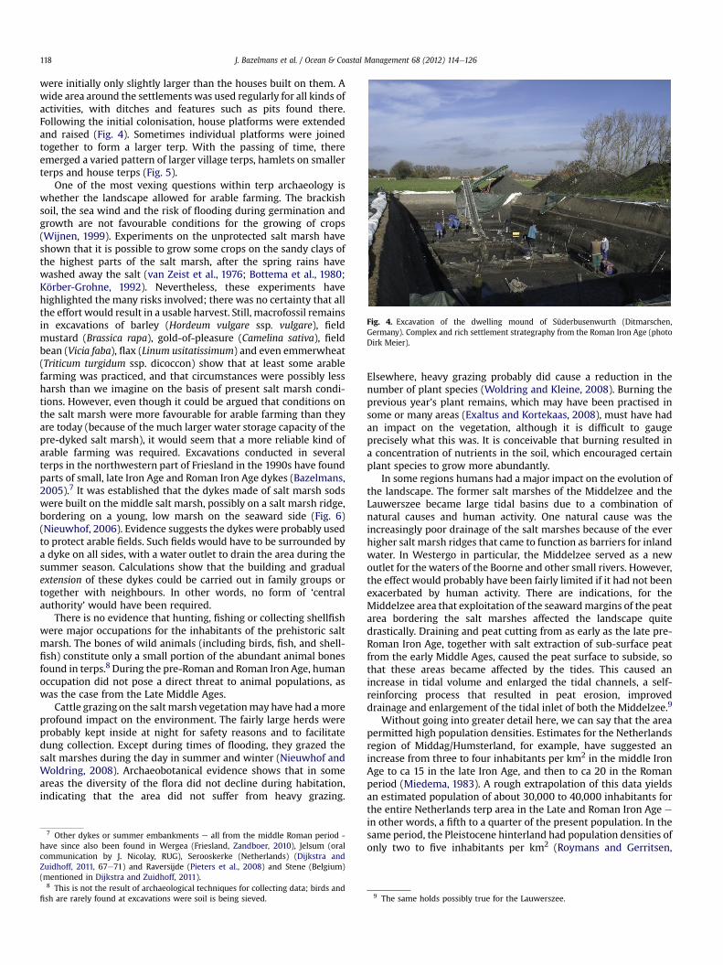
were initially only slightly larger than the houses built on them. Awide area around the settlements was used regularly for all kinds ofactivities, with ditches and features such as pits found there.Following the initial colonisation, house platforms were extendedand raised (Fig. 4). Sometimes individual platforms were joinedtogether to form a larger terp. With the passing of time, thereemerged a varied pattern of larger village terps, hamlets on smallerterps and house terps (Fig. 5).
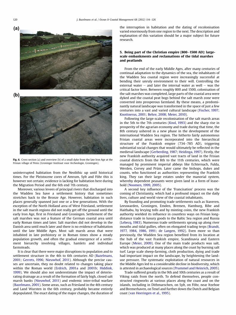
One of the most vexing questions within terp archaeology iswhether the landscape allowed for arable farming. The brackishsoil, the sea wind and the risk of flooding during germination andgrowth are not favourable conditions for the growing of crops(Wijnen, 1999). Experiments on the unprotected salt marsh haveshown that it is possible to grow some crops on the sandy clays ofthe highest parts of the salt marsh, after the spring rains havewashed away the salt (van Zeist et al., 1976; Bottema et al., 1980;Körber-Grohne, 1992). Nevertheless, these experiments havehighlighted the many risks involved; there was no certainty that allthe effort would result in a usable harvest. Still, macrofossil remainsin excavations of barley (Hordeum vulgare ssp. vulgare), fieldmustard (Brassica rapa), gold-of-pleasure (Camelina sativa), fieldbean (Vicia faba), flax (Linum usitatissimum) and even emmerwheat(Triticum turgidum ssp. dicoccon) show that at least some arablefarming was practiced, and that circumstances were possibly lessharsh than we imagine on the basis of present salt marsh condi-tions. However, even though it could be argued that conditions onthe salt marsh were more favourable for arable farming than theyare today (because of the much larger water storage capacity of thepre-dyked salt marsh), it would seem that a more reliable kind ofarable farming was required. Excavations conducted in severalterps in the northwestern part of Friesland in the 1990s have foundparts of small, late Iron Age and Roman Iron Age dykes (Bazelmans,2005).7 It was established that the dykes made of salt marsh sodswere built on the middle salt marsh, possibly on a salt marsh ridge,bordering on a young, low marsh on the seaward side (Fig. 6)(Nieuwhof, 2006). Evidence suggests the dykes were probably usedto protect arable fields. Such fields would have to be surrounded bya dyke on all sides, with a water outlet to drain the area during thesummer season. Calculations show that the building and gradualextension of these dykes could be carried out in family groups ortogether with neighbours. In other words, no form of ‘centralauthority’ would have been required.
There is no evidence that hunting, fishing or collecting shellfishwere major occupations for the inhabitants of the prehistoric saltmarsh. The bones of wild animals (including birds, fish, and shell-fish) constitute only a small portion of the abundant animal bonesfound in terps.8 During the pre-Roman and Roman Iron Age, humanoccupation did not pose a direct threat to animal populations, aswas the case from the Late Middle Ages.
Cattle grazing on the salt marsh vegetationmay have had amoreprofound impact on the environment. The fairly large herds wereprobably kept inside at night for safety reasons and to facilitatedung collection. Except during times of flooding, they grazed thesalt marshes during the day in summer and winter (Nieuwhof andWoldring, 2008). Archaeobotanical evidence shows that in someareas the diversity of the flora did not decline during habitation,indicating that the area did not suffer from heavy grazing.
7 Other dykes or summer embankments e all from the middle Roman period -have since also been found in Wergea (Friesland, Zandboer, 2010), Jelsum (oralcommunication by J. Nicolay, RUG), Serooskerke (Netherlands) (Dijkstra andZuidhoff, 2011, 67e71) and Raversijde (Pieters et al., 2008) and Stene (Belgium)(mentioned in Dijkstra and Zuidhoff, 2011).
8 This is not the result of archaeological techniques for collecting data; birds andfish are rarely found at excavations were soil is being sieved.
Elsewhere, heavy grazing probably did cause a reduction in thenumber of plant species (Woldring and Kleine, 2008). Burning theprevious year’s plant remains, which may have been practised insome or many areas (Exaltus and Kortekaas, 2008), must have hadan impact on the vegetation, although it is difficult to gaugeprecisely what this was. It is conceivable that burning resulted ina concentration of nutrients in the soil, which encouraged certainplant species to grow more abundantly.
In some regions humans had a major impact on the evolution ofthe landscape. The former salt marshes of the Middelzee and theLauwerszee became large tidal basins due to a combination ofnatural causes and human activity. One natural cause was theincreasingly poor drainage of the salt marshes because of the everhigher salt marsh ridges that came to function as barriers for inlandwater. In Westergo in particular, the Middelzee served as a newoutlet for the waters of the Boorne and other small rivers. However,the effect would probably have been fairly limited if it had not beenexacerbated by human activity. There are indications, for theMiddelzee area that exploitation of the seawardmargins of the peatarea bordering the salt marshes affected the landscape quitedrastically. Draining and peat cutting from as early as the late pre-Roman Iron Age, together with salt extraction of sub-surface peatfrom the early Middle Ages, caused the peat surface to subside, sothat these areas became affected by the tides. This caused anincrease in tidal volume and enlarged the tidal channels, a self-reinforcing process that resulted in peat erosion, improveddrainage and enlargement of the tidal inlet of both the Middelzee.9
Without going into greater detail here, we can say that the areapermitted high population densities. Estimates for the Netherlandsregion of Middag/Humsterland, for example, have suggested anincrease from three to four inhabitants per km2 in the middle IronAge to ca 15 in the late Iron Age, and then to ca 20 in the Romanperiod (Miedema, 1983). A rough extrapolation of this data yieldsan estimated population of about 30,000 to 40,000 inhabitants forthe entire Netherlands terp area in the Late and Roman Iron Age e
in other words, a fifth to a quarter of the present population. In thesame period, the Pleistocene hinterland had population densities ofonly two to five inhabitants per km2 (Roymans and Gerritsen,
9 The same holds possibly true for the Lauwerszee.
Fig. 5. Development of the dwelling mound of the German Feddersen Wierde, 100 BCe450 AD (Land Wursten).
J. Bazelmans et al. / Ocean & Coastal Management 68 (2012) 114e126 119
2002). The difference between the coastal area and the hinterlandcan be traced back to the difference in biomass production.Whereas one cow per hectare can be grazed on salt marshes, atleast 6 ha are required on sandy soils (Brinkkemper, 1991).
There are big differences in colonisation and population growthin the different subareas of theWadden Sea region. On large islands(like Sylt, Föhr and Texel) and continuous sandy dune areas (as inthe western Netherlands), there appears to have been almost
Fig. 6. Cross section (a) and overview (b) of a small dyke from the late Iron Age at theFrisian village of Peins (Groninger Instituut voor Archeologie, Groningen).
J. Bazelmans et al. / Ocean & Coastal Management 68 (2012) 114e126120
uninterrupted habitation from the Neolithic up until historicaltimes. For the Pleistocene cores of Amrum, Sylt and Föhr this ishowever not certain; evidence is lacking for habitation here duringthe Migration Period and the 6th end 7th century.
Moreover, various levees of principal rivers that discharged intothe Wadden Sea have a settlement history that sometimesstretches back to the Bronze Age. However, habitation in suchplaces generally spanned just one or a few generations. With theexception of the North Holland area of West Friesland, settlementin the salt marsh regions did not really get off the ground until theearly Iron Age, first in Friesland and Groningen. Settlement of thesalt marshes was not a feature of the German coastal area untilearly Roman times and later. Salt marshes did not develop in theDanish area until much later and there is no evidence of habitationuntil the late Middle Ages. Most salt marsh areas that wereinhabited in late prehistory or in Roman times show a steadypopulation growth, and often the gradual emergence of a settle-ment hierarchy involving villages, hamlets and individualfarmsteads.
It is clear that there were major disruptions to population and tosettlement structure in the 4th to 6th centuries AD (Bazelmans,2001; Gerrets, 1996; Nieuwhof, 2011). Although the precise cau-ses are uncertain, they no doubt related to changes taking placewithin the Roman world (Erdrich, 2001a and 2001b; Hiddink,1999). We should also not underestimate the impact of deterio-rating drainage as a result of the formation of fairly high, closed saltmarsh banks (Nieuwhof, 2011) and endemic inter-tribal warfare(Bazelmans, 2001). Some areas, such as Friesland in the 4th centuryand Land Wursten in the 6th century, probably became entirelydepopulated. The exact dating of the major changes, the duration of
the interruption in habitation and the dating of recolonisationvaried enormously from one region to the next. The description andexplanation of this variation should be a major subject for futureresearch.
5. Being part of the Christian empire (800e1500 AD): large-scale embankments and reclamations of the tidal marshesand peatlands
From the end of the early Middle Ages, after many centuries ofcontinual adaptation to the dynamics of the sea, the inhabitants ofthe Wadden Sea coastal region were increasingly successful atbending their unruly environment to their will. Controlling theexternal water e and later the internal water as well e was thecritical factor here. Between roughly 800 and 1500, colonisation ofthe salt marshes was completed, large parts of the coastal areaweredyked and the coastal peat bogs behind the salt marsh zone wereconverted into prosperous farmland. By these means, a predomi-nantly natural landscape was transformed in the space of just a fewcenturies into a vast and varied cultural landscape (Fischer, 1997;Knottnerus, 2001; Behre, 2008; Meier, 2010).
Following the large-scale recolonisation of the salt marsh areasin the 5th to the 7th centuries (Knol, 1993) and the sharp rise inprosperity of the agrarian economy and trade during that time, the8th century ushered in a new phase in the development of theinternational Wadden Sea region. The hitherto fairly autonomousFrisian coastal areas were incorporated into the hierarchicalstructure of the Frankish empire (734e785 AD), triggeringsubstantial social changes that would ultimately be reflected in themedieval landscape (Gerberding, 1987; Heidinga, 1997). Firstly, thenew Frankish authority acquired vast tracts of land in the Frisiancoastal districts from the 8th to the 11th centuries, which weremanaged by prominent imperial abbeys like Echternach, Fulda,Werden, Corvey and Prüm. Later came the bishops, dukes andcounts, who functioned as authorities representing the Frankishking. They ran their large estates under the manorial system,whereby dependent peasants were given land in a form of lease-hold (Noomen, 1999, 2005).
A second key influence of the ‘Francisation’ process was thecoming of Christianity, which had a profound impact on the dailylives, culture and world view of the coastal inhabitants.
By founding and promoting trade settlements such as Staveren,Leeuwarden, Groningen, Emden, Bremen, Hamburg, Ribe andHaithabu, by levying tolls and by minting coins, the new Frankishauthority wielded its influence in countless ways on Frisian long-distance trade in luxury goods to the Baltic Sea region and Russia(Lebecq, 1983). Numerous trade settlements sprung up along rivermouths and tidal gullies, often on elongated trading terps (Brandt,1977, 1984, 1986, 1991; de Langen, 1992). Even more so thanpreviously, the Wadden Sea region benefited from its location atthe hub of the vast Frankish empire, Scandinavia and EasternEurope (Meier, 2009). One of the main trade products was salt,which was produced at many places along the coast by burning saltturf. Large scale sheep-farming, cloth production, dying and tradehad important impact on the landscape, by heightening the land-use pressure. The systematic exploitation of natural resources inthe Middle Ages led to a considerable decline in biodiversity, whichis attested in archaeological sources (Prummel and Heinrich, 2005).
Trade suffered greatly in the 9th and 10th centuries as a result ofViking raids from the north. To defend themselves, people con-structed ringworks at various places along the coast and on theislands, including in Dithmarschen, on Sylt, on Föhr, near Itzehoeand Bremerhaven, on Texel and further down the Dutch and Belgiancoast (van Heeringen et al., 1995).
J. Bazelmans et al. / Ocean & Coastal Management 68 (2012) 114e126 121
The rapid population growth and great prosperity of the saltmarshes in the early Middle Ages meant that any salt marsh bankssuitable for habitation soon became fully populated, compellingearly medieval coastal dwellers to explore new places to live andwork (Knol, 1993; De Langen, 1992). These they found in threedifferent landscapes of the Wadden Sea region: the salt marshfringes, the peatland bordering salt marsh gullies, small rivers anddrainage channels, and the inland peat moors. To begin with, fromthe 7th century onwards, they increasingly sought refuge in thesalt marsh fringes, where the salt marsh passed from a thin layerof clay on peat to fairly elevated sphagnum bog zones. Colonistsbegan to occupy and reclaim these new territories, starting fromthe southern fringes of the salt marsh and working their way intothe coastal peat bogs, laying the foundation for the stripfieldparcellations and elongated peat settlements that have becomecharacteristic features of the medieval peatland (Fig. 7). Particu-larly in the Netherlands part of the Wadden region, these saltmarsh fringes were probably already largely settled in the 9thcentury (de Langen, 2011), whereas in northern Germany coloni-sation of these areas probably did not occur until the 10th and11th centuries (Meier, 2011; Groenendijk and Schwarz, 1991). Asthe peat consolidated and oxidized, the ground level of thereclaimed areas in the salt marsh fringes fell substantially andthese areas often fell prey to the sea. Today, most of them lie
Fig. 7. Systems of medieval stripfield parcellations in the Frisian area of Oostergo in the peatLangen, 1992).
buried beneath a layer of clay. The inhabitants were sometimesable to hold out under these conditions by erecting terps or byonly living, working (e.g. producing salt) and grazing stock there inthe summer months.
The reclamations of the early medieval salt marsh fringesanticipated the much grander scale colonisation and reclamation ofthe coastal and inland peat bogs that would take place from the late9th and the 10th century (De Langen, 1992, 2011). As well ascontinuing to reclaim the fringes, growing numbers of colonistsmoved upstream, away from the coastal area to the tidal gullies,brooks and streams in order to systematically reclaim the peat bogs(through river reclamations). The first settlements e often in a longline parallel to a river ewere built on the slopes of the peat domes,with ditches dug diagonally to the river for easy drainage. After thepassage of time, oxidation and peat consolidation often lowered theground level to such a degree that a new settlement had to be builtfurther upward in the peat bogs. In the 10th and up until the 13thcentury, large tracts of peat bog and fenlands in the northernNetherlands and northern Germany were put into cultivation.These inland peat moors, which originally rose high above the levelof the sea and salt marshes, sank many metres in just a fewcenturies, partly as a result of large-scale, anthropogenic soilsubsidence. This led to major problems with the internal andexternal water in the later Middle Ages.
bog area south and east of the marsh area which was inhabited since the Iron Age (De
J. Bazelmans et al. / Ocean & Coastal Management 68 (2012) 114e126122
Although the first low dykes had been built in the terp region inthe first few centuries AD to protect the farmed land from flooding,it was not until the 11th century that somewhat larger dykes wereerected in the Frisian coastal area. We know, for example, that theinhabitants of several terp villages in Westergo joined forces toconstruct a ring dyke measuring 1e1.5 m in height. These earlyring-dyke polders are also called ‘mother’ polders (Rienks andWalther, 1954). They were gradually joined together, eventuallyforming a continuous ring dyke around the whole of Westergo inthe 11th century. Continuous ring dykes were also built in otherparts of Friesland and Groningen in about the 12th century (Kooper,1939; Schroor and Meijering, 2007). In Lower Saxony andSchleswig-Holstein, such dykes date mainly from the 12th and 13thcenturies (Kühn, 1989; Schmid, 1991; Behre and Van Lengen, 1995;Vollmer et al., 2001; Meier, 2001, 2005; Ey, 2007).
Also of great age are the river dykes which were built in Fries-land around the 11th century along the Boorne, Ee and other riversto protect the reclaimed peat landscapes (Rienks and Walther,1954; de Langen, 2011). A start was also made in the 13thcentury on the ‘offensive dyking’ of silted-up tidal basins like thoseof the Marne, Middelzee, Fivel bay, Krümmhorn and the Eiderstedtarea (Krämer, 1984). For the first time in the history of the Wad-densea area, man started to regain land from the sea. Unembankedareas along the coast were stimulated to silt up between smallbrushwood embankments and were subsequently endiked. A greatnumber of fertile new polders were reclaimed in this way (Fig. 8).The damming of tidal gullies and river mouths by means of dykelocks (Dutch zijlen, German Siele) was another important techniquefor controlling external water. Eventually, by about 1500, this led toa series of linked sea dykes along the Wadden coast, with tidalbasins penetrating far inland in just a few places.
In many places dyke construction put an end to natural drainageof the land via tidal basins. Everywhere, new ditches had to be dugand the inhabitants of the new polders had to take charge of watermanagement. In the 13th century, numerous water boards (Dutchzijlvesten, German Köge and Sielachten, Danish kogen) were createdfor this purpose in the coastal areas along the Wadden Sea.
Another significant outcome of the progressive dyking of thesalt marshes was that this enabled settlements to be built on flatground in the newly created polders. From the 13the14th centuriesonwards, numerous villages and an even larger number of indi-vidual farmsteads sprang up. The absence of floods meant that thesurrounding farmland could now be exploited much more
Fig. 8. The medieval and (early) modern embankment of the peninsula of Eiderstedt(design Dirk Meier).
intensively. The flourishing agrarian economy and strong pop-ulation growth of the 16th century accelerated this new inlandoccupation.
The extensive reclamations and dyke building in the coastalareas of the Wadden region also had negative consequences for thelandscape. Up until the 12the13th centuries, at times when waterlevels were extremely high, the sea had a very large storagecapacity in the form of many hundreds of square kilometres ofundyked salt marshes. Large-scale dyke construction meant thatthe salt marshes were no longer available for this purpose, and thewater in the tidal basins was pushed up much higher than before.The dykes, which were still low at this time, were often not up thetask. Besides, the large-scale reclamations and draining of thefenlands caused a considerable lowering of the surface level, whichmade them extremely vulnerable for sea incursions. From the late12th to the early 16th century, there were innumerable major seaincursions in the Netherlands, German and Danish Wadden region,with disastrous consequences (Fig. 9). Examples are the floods inthe Jadebusen, Dollard, Leybucht and the North-Frisian Uthlande(Knottnerus, 2001; Meier, 2004, 2012). Many marine clay polderswere flooded, coastal villages disappeared, islands vanished ormoved, and large tracts of peat bog were washed away. A furtherproblemwas that the ground level in the hinterland e in particularthe reclaimed peatland e had fallen sharply as a consequence ofoxidation and settling, making these areas highly vulnerable toflooding. A third factor may have been the large-scale salt har-vesting in the coastal area, which created many depressions in thelandscape. Thus the late medieval sea incursions were caused notso much by natural factors, but by anthropogenic ones. In thecenturies that followed, the tidal inlets and basins that arose werelargely embanked once again by means of offensive dyking. A smallportion of the formerly flooded areas, particularly in the GermanWadden Sea region, still lies outside the dykes, and traces of earliersettlements and cultural landscapes can regularly be seen on themudflats (Heinze, 2000).
In the 12th and 13th centuries, the dominant role of distantauthorities and landowners in the coastal Wadden Sea districtsincreasingly gave way to an ever smaller-scale political system of40e50 small, autonomous coastal republics controlled largely bythe local elite (often networks of noble families) (Van Lengen, 2003;Schmidt, 1975, 2005). That same period also saw the emergence ofnew consultation and decision-making structures for the purposes
Fig. 9. Drowned landscape of the North-Frisian Uthlande. Remains of a stack dike ofthe island of Strand, destroyed in 1634 (photo Dirk Meier).
J. Bazelmans et al. / Ocean & Coastal Management 68 (2012) 114e126 123
of regulating water management, justice and defence (Frieswijket al., 1999). These structures often proved rather unstable. More-over, conflicts of interest arose in many areas between the variousfamily networks, somuch so that the lateMiddle Ages are known asa period of political disputes, feuds and vendettas. The region’scities were actively involved. It is no coincidence that the nobilityerected local fortifications and castles, such as borgen and stins-wieren, virtually throughout the Wadden Sea region (Noomen,2009). These fortifications are restricted to the coastal landscapesof the northern Netherlands, Ostfrisia and the Elbe river mouth.However, they generally lack in the Wadden regions ofSchleswigeHolstein and Denmark, probably because there was nolarge-scale brick production in these areas.
It was not only the local and regional nobility who enjoyed greatprosperity during these few centuries. Monasteries also thrived inthe region from the end of the 12th century. More than 200monasteries sprang up in the coastal areas during the late MiddleAges, with about 15e25 percent of the land in their control (Mol,1991). The monasteries wielded considerable influence on localsociety in many areas through the economic exploitation of farms(home farms and outfarms), dyke-building (Mol, 1992) through turfand clay extraction and through the requisite improvement inregional drainage. This period also saw the appearance of hundredsof new churches in the Wadden Sea region, in Romanesque,Romanesque Gothic and later also Gothic style. With theirdistinctive towers, these churches are prominent features of thelandscape to this day. The construction of hundreds of villagechurches was not the consequence of reclamation but rather ofmore profound Christianization and the actions of local elites,trying to get more influence on their surroundings by foundingprivate churches. The crusades had a lot of impact too, as thereturning crusaders became acquainted with urban culture.
A third important development was the rise of towns and tradein the later Middle Ages. As a consequence of the emerging BalticSea trade and the formation of the large international HanseaticLeague, cities like Ribe, Hamburg, Stade, Bremen, Groningen andStavoren enjoyed immense prosperity from the 12th to the 14thcenturies. Key factors here were the fast and efficient new types ofship, such as the Hanze kogge, the Frisian hulk, the kraweel and theDutch marsschip (Brand, 2007; Meier, 2009).
6. The Wadden sea area as part of the early modern worldsystem (1500e1800): agricultural and maritime innovation astriggers for prosperity
Evenmore so than the heyday of Frisian trade in the earlyMiddleAges, the early modern era e with its flourishing agricultural andmaritime cultures e can be seen as the period of greatest economicprosperity for the Wadden region. From the 16th century, theregional economies increasingly became part of a world economy.The rapidly expanding economy of the Dutch Golden Age focusednot only on European long-distance trade, but to an increasingdegree on the newly discovered colonial areas of Asia and America(Wallerstein, 1974e1988). Grain and timber supply from the Balticwere key pillars of this economy. In the 16th and 17th centuries thecoastal harbours and coastal zones of the Wadden region benefitedenormously from their position as way stations between the townsofHolland and theBaltic (Roding&HeermavanVoss,1997). Both themaritime and agricultural economies were given a significant boost(Westerdahl, 1992, 2007). The region’s population rose sharplyduring this time, from an average of 15e25 inhabitants per km2 inabout 1500 AD to 30e50 inhabitants per km2 in about 1800 AD.Although there was no need for major changes to the overall spatialstructure of the landscape, many far-reaching adaptations andinnovations were introduced to many landscape elements between
1500and1800AD, changes that determine its appearance to thisday(Knottnerus, 2001).
At the start of the 16th century, the Frisian coastal areas losttheir political independence and were incorporated into larger,centrally controlled territorial states. In practice, because of theremoteness from centres of power, authority was usually delegatedto officials, most of whom came from old noble families. For thisreason the rural elite e noble owners of large estates and largegentlemen farmers e continued to exert a profound influence onlocal and regional governments, on the administration of justiceand onwater boards right up until the 19th century (Frieswijk et al.,1999). Together with the urban elite and leading figures inmercantile shipping (e.g. shipowners and ship commanders’families), they controlled a highly commercialised trade economythat was very successful in both the agricultural and maritimesectors. Compared with the more feudal societies in the interior,freedom and local and personal autonomy played an important rolein this coastal society. In religious terms, the vast majority of thecoastal areas converted to the Calvinist (Netherlands) and Lutheran(Germany) faiths, which were fairly tolerant of minorities(Knottnerus, 2001). Locally, more conservative, ‘experiential’ formsof Protestantism predominated, a phenomenon that can also befound in coastal regions elsewhere.
The flourishing maritime economy that developed in the Wad-den Sea region from the 16th century onward led to many land-scape changes, both large and small (Westerdahl, 1992, 2007). Inthe Wadden itself and on the islands, an increasingly fine networkof shipping routes appeared, marked by beacons, lighthouses andbuoys. And in the towns and villages along the coast, the growingimportance of merchant shipping, inland shipping and fishing wasexpressed not just in a host of new commercial buildings, harboursand art works, but also in the spatial structure and architecture ofthe villages (e.g. market squares, fishing districts, trading andcraftsmen quarters, grand streets with patrician mansions, newhouses and churches in Renaissance, Baroque and Classical styles).
Although major flooding by seawater was much less frequentfrom the mid-16th century than in the late Middle Ages, countlesshydraulic improvements were carried out in the Wadden Searegion between 1500 and 1800. These had three objectives: coastaldefence, regulation of the internal water, and the advancement ofinland shipping. Sea dykes along the coast were heightened andstrengthened (Knottnerus, 2005a,b), new tidal harbours with lockswere constructed and many new marine clay polders were dyked.Inland, the inhabitants dug a very fine network of waterways toallow the water to drain more easily from the peat and marine clayareas to the sea, and to vastly improve inland shipping. Many shipscould now avoid the treacherous sea routes and instead travel long-distance routes inland. Almost every village in the marine clay andpeat areas of the Netherlands and the eastern part of East Frisiawere linked to this maritime network by means of canals andaccess channels. The maritime cultural landscape of the WaddenSea region was therefore located not only along the coast butextended far inland as well. For the most part, inland ships such astow barges carried agricultural products, turf and passengers.Significant innovations were also introduced to sea fishing in thisperiod, with whaling beginning to flourish from the beginning ofthe 17th century. In the early modern period, the hunting ofharbour seals, grey seals, dolphins and harbour porpoises wasa further important source of additional income, particularly forisland and coastal inhabitants.
In the period 1500e1800, a significant part of the Waddenregion countryside was geared toward international export (Rodingand Heerma van Voss, 1997). Thanks to economies of scale, inten-sification of production and new technologies, this coastal regiondeveloped to become one of the most successful agricultural areas
J. Bazelmans et al. / Ocean & Coastal Management 68 (2012) 114e126124
in Europe. Many of the production systems that evolvedwere basedon a closely interwoven network spanning different regions, eachof which was responsible for its own link in the agricultural chain.One example is the flourishing international cattle trade of the 16thand 17th centuries. These animals were bred in Denmark, fattenedin Northern Germany and the Netherlands, and then sold for meatin the cities of Holland (Westermann, 1979; Gijsbers, 1999). Animportant differencewithin theWadden regionwas the integrationin the von Thünian circles of the Dutch urban core: the westernparts confined themselves largely to cattle-raising and dairyfarming, the eastern parts, lying farther from the Dutch staplemarkets, exported cereals too. After about 1750 the whole area wastransformed by an agricultural boom, caused by intensification ofcereal growing and exports.
Also important was the large-scale hiring of migrant workersfromWestphalia and Lower Saxony at haymaking and harvest time.The presence of a flourishing maritime culture was a vitalprecondition for the sharp rise in production in the early modernWadden Sea region. This increasing prosperity was reflected in thelandscape not just in the increasingly sophisticated network ofinland waterways e restricted to the western part of the area - andnew marine clay polders with their large-scale, rationalised plotdivisions. We see it too in the new types of farmhouse (the three-aisled Frisian barn, the ‘stolp’ farmhouse and Gulfhaus) with theiropulent residential sections and gardens, which were built bygentlemen farmers.
7. Conclusions
From a social evolutionairy point of view it is interesting toconclude that the coastal zone of the northern Netherlands,Germany and southwestern Denmark was a very rich environmentin pre-modern times. In comparison to most transalpine areaspopulation density and average settlement size seem to have beenhigh during most periods of time and in most marsh areas.However, no complex political hierarchies above the tribal level diddevelop within the area. Possibly, the ‘societal format’ (Claessen,2000) did not provide for the necessary preconditions: the totalnumbers of inhabitants was too low and resources too evenlydistributed. In addition the area was difficult to control because itwasmore of an archipelago of dozens of societies then a continuousspace of habitation. The changeover to the construction ofembankements did not provide an incentive for political central-isation too (in contrast to developments within most others‘hydraulical societies’ (cf. Wittfogel, 1957)). Dykes could be build,extended and maintained within relatively small communities.Relatively high population numbers, an indigenous ‘prestigeeconomy’ centred on the establishment of awarrior’s fame (and thecapture of valuables like cattle) and the absence of a statemonopoly on the use of violence did provide for a situation inwhich inter-tribal raiding and warfare were endemic. This came toa definitive end only at the beginning of the early modern era, asa result of conquest of the Wadden region by outside state powers.
Over the course of about two and half thousand years, humansbecame a significant geological factor through the successive use ofmanpower, animal power and wind power. The coming of theindustrial revolutionmeant that fossil fuels could also be harnessedto make dramatic changes to the landscape. The widespreadstrengthening of existing dykes and the construction of newpolders, dune dykes and dams would be unthinkable without theuse of large ships, dredgers and excavators. The stench of exhaustgases rather than sweat became the distinctive odour of people’sengagement with the landscape.
Despite the far-reaching modernisation of the Wadden land-scape in the past 150 years, the many terps and dykes, together
with the complex plot system, are evidence to this day of the longhistory of interaction between people and environment discussedhere. This is what makes it one of the oldest and most complexcultural landscapes in Europe and the world today. It is not just thenatural values of the region, as demonstrated by its world heritagestatus, that deserve preservation. The cultural historical values areimportant too. The traces of the region’s millennia-long, oftenchangeable history are not only valuable in themselves, as materialfor a historical narrative, but because they enable us to reflect onthe region’s present and future.
References
Baeteman, C., Waller, M., Kiden, P., 2011. Reconstructing middle to late Holocenesea-level change: a methodological review with particular reference to a newHolocene sea-level curve for the southern North Sea’ presented by K.-E. Behre.Boreas, 1e16.
Bazelmans, J., Groenendijk, H., de Langen, G., Nicolay, J., Nieuwhof, A., 2011a. De lateprehistorie en protohistorie van Holoceen Noord-Nederland. Leeuwarden.
Bazelmans, J., van der Meulen, M., Vos, P., Weerts, H. (Eds.), 2011b. Atlas vanNederland in het Holoceen. Landschap en bewoning vanaf de laatste ijstijd totnu, Amsterdam (maps by P. Vos).
Bazelmans, J., 2001. Die spätrömerzeitliche Besiedlungslücke im niederländischenKüstengebiet und das Fortbestehen des Friesennamens. Emder Jahrbuch 81,7e61.
Bazelmans, J., 2005. Die Wurten von Dongjum-Heringa, Peins-Oost undWijnaldum-Tjitsma: kleinmabstäblicher Deichbau in ur- und frühge-schichtlicher Zeit des nördlichen Westergo. In: Fansa, M. (Ed.), KulturlandschaftMarsch. Natur e Geschichte e Gegenwart. Oldenburg (Schriftenreihe desLandesmuseums für Natur und Mensch Oldenburg 33), pp. 68e84.
Beets, D.J., van der Spek, A.J.F., 2000. The Holocene evolution of the barrier andback-barrier basin of Belgium and the Netherlands as a function of lateWeichselian morphology, relative sea-level rise and sediment supply.Netherlands Journal of Geosciences 79, 3e16.
Beets, D.J., van der Spek, A.J.F., van der Valk, L., 1994. Holocene ontwikkeling van deNederlandse kust. Haarlem (RGD rapport 40.016, Project Kustgenese).
Behre, K.-E., 1999. Die Veränderung der niedersächsischen Küstenlinien in denletzten 3000 Jahren und ihre Ursachen. Probleme der Küstenforschung imsüdlichen Nordseegebiet 26, 9e33.
Behre, K.-E., 2003. Eine neue Meeresspiegelkurve für die südliche Nordseeküste.Transgressionen und Regressionen in den letzten 10.000 Jahren. Probleme derKüstenforschung im südlichen Nordseegebiet 28, 9e63.
Behre, K.-E., 2004. Coastal development, sea-level change and settlement historyduring the later Holocene in the Clay District of Lower Saxony Niedersachsen,northern Germany. Quaternary International 112, 37e53.
Behre, K.E., 2008. Landschaftsgeschichte Norddeutschlands. Umwelt und Siedlungvon der Steinzeit bis zur Gegenwart. Neumünster.
Behre, K.E., van Lengen, H., 1995. Ostfriesland. Geschichte und Gestalt einer Kul-turlandschaft. Aurich.
Bottema, S., van Hoorn, T.C., Woldring, H., Gremmen, W.H.E., 1980. An agriculturalexperiment in the unprotected salt marsh. Part II. Palaeohistoria 22, 128e140.
Brand, H. (Ed.), 2007. The German Hanse in Past and Present Europe: A MedievalLeague as a Model for Modern Interregional Cooperation? Groningen.
Brandt, K., 1977. Handelsplätze des frühen und hohen Mittelalters in der Marschzwischen Ems- und Wesermündung, Ein Vorbericht über archäologisch-his-torische Untersuchungen. ZAM 5, 121e144.
Brandt, K., 1986. Archäologische Untersuchungen in einem mittelalterlichenMarktort an der Nordseeküste, Ergebnisse der Ausgrabungen in Langwarden,Ldkrs. Wesermarsch. PKSN 16, 127e169.
Brandt, K., 1991. Die Ergebnisse in den Grabungen der Wurten Niens und Sie-vertsborch(Kreis Wesermarsch). Probleme der Küstenforschung im südlichenNordseegebiet 18, 89e140.
Brandt, K., 1984. Langwurten, ihre Topographie und ihre Funktion. In: Jankuhn, H.,et al. (Eds.), Archäologische und naturwissenschaftliche Untersuchungen anSiedlungen im deutschen Küstengebiet, 2: Handelsplätze des frühen und hohenMittelalters, pp. 100e113. Weinheim.
Brinkkemper, O., 1991. Wetland Farming in the Area South of the Meuse Estuaryduring the Iron Age and Roman Period, an Environmental and Palaeo-economicReconstruction. Leiden.
Bungenstock, F., Weerts, H., 2009. The high-resolution Holocene sea-level curve forNorthwest Germany: global signals, local effects or data-artefacts? Interna-tional Journal of Earth Sciences 99, 1687e1706.
Claessen, H.J.M., 2000. Problems, Paradoxes, and Prospects of Evolutionism. In:Kradin, N.N., Korotayev, A.V., Bondarenko, D.M., de Munck, V., Wason, P.K.(Eds.), Alternatives of Social Evolution, pp. 1e11. Vladivostok.
Dijkstra, J., Zuidhoff, F.S., 2011. Kansen op de kwelder. Archeologisch onderzoek open rond negen vindplaatsen in het nieuwe tracé van de Rijksweg 57 en denieuwe rondweg ter hoogte van Serooskerke (Walcheren). Amersfoort (ADCMonografie 10).
Ehlers, J., 1988. The Morphodynamics of the Wadden Sea. Rotterdam.
J. Bazelmans et al. / Ocean & Coastal Management 68 (2012) 114e126 125
Erdrich, M., 2001a. Wirtschaftsbeziehungen zwischen der Germania Inferior unddem germanischen Vorland - ein Wunschbild. In: Grünewald, T. (Ed.), Germaniainferior. Besiedlung, Gesellschaft und Wirtschaft an den Grenze der römisch-germanischen Welt, pp. 306e335. Berlin/New York.
Erdrich, M., 2001b. Rom und die Barbaren. Das Verhältnis zwischen dem ImperiumRomanum und den germanischen Stämmen vor seiner Nordwestgrenze von derspäten römischen Republik bis zum Gallischen Sonderreich. In: Römisch-Ger-manische Forschungen, 58. Mainz am Rhein.
Essex County Council, 2010. Comparative Analysis of the Landscape and CulturalHeritage of the Wadden Sea Region. County Hall.
Ey, J., 2007. Early dike construction in the coastal area of Lower Saxony. In:Beenaker, J.J.J.M., et al. (Eds.), Landschap in ruimte en tijd, pp. 92e99. Amsterdam.
Fischer, L. (Ed.), 1997. Kulturlandschaft Nordseemarschen. Bredstedt/Westerhever.Fokkens, H., 1998. Drowned Landscape. The Occupation of the Western Part of the
Frisian-Drentian Plateau, 4400 BCeAD 500. Assen.Frieswijk, J., et al. (Eds.), 1999. Fryslân, staat en macht 1450e1650. Hilversum.Gaffney, V., Thomson, K., Fitch, S. (Eds.), 2007. Mapping Doggerland. The Mesolithic
Landscapes of the Southern North Sea. Birmingham.Gerberding, R., 1987. The Rise of the Carolingians and the Liber Historiae Francorum.
Oxford.Gerrets, D.A., 1996. Continuity and change in house construction and the lay-out of
rural settlements during the early Middle Ages in the Netherlands. Ruralia 1,33e46. Prague (Památky Archeologické, Supplement 5).
Gijn, A.L. van, Waterbolk, H.T., 1984. The colonization of the salt marshes of Fries-land and Groningen: the possibilities of a transhumant prelude. Paleohistoria26, 101e122.
Gijsbers, W., 1999. Kapitale ossen. De internationale handel in slachtvee inNoordwest-Europa 1300e1750. Amsterdam.
Groenendijk, H.A., Schwarz, W., 1991. Mittelalterliche Besiedlung der Moore imEinflußbereich des Dollarts: Ergebnisse und Perspektiven. In: ArchäologischeMitteilungen aus Nordwestdeutschland 14, pp. 39e68.
Heeringen, R.M., Hendrikx, P.A., Mars, A., 1995. Vroegmiddeleeuwse ring-walburchten in Zeeland. Goes.
Heidinga, H.A., 1997. Frisia in the First Millenium. An Outline. Utrecht.Heinze, A., 2000. Archäologische Funde im ostfriesischen Watt. In: Jaarverslagen
van de Vereniging voor Terpenonderzoek, 82, Groningen, pp. 76e97.Hiddink, H., 1999. Germaanse samenlevingen tussen Rijn en Weser. Amsterdam.Hoffmann, D., 2004. Holocene landscape development in the marshes of the West
Coast of Schleswig-Holstein, Germany. Quaternary International 112, 29e36.Hoffmann, D., Meier, D., Müller-Wille, M., 2007. Geologische und archäologische
Untersuchungen zur Landschafts- und Siedlungsgeschichte des Küstengebietesvon Norderdithmarschen, Germania. pp 213e253.
IJzereef, G., 1981. Bronze Age Animal Bones from Bovenkarspel. The Excavation atHet Valkje. Amersfoort (Nederlandse Oudheden 10).
Kiden, P., Denys, L., Johnston, P., 2002. Late Quaternary sea-level change and isostaticand tectonic land movements along the Belgian-Dutch North Sea coast:geological data and model results. Journal of Quaternary Science 17, 535e546.
Kiden, P., Makaske, B., van de Plassche, O., 2008. Waarom verschillen de zees-piegelrecon structies voor Nederland? Grondboor en hamer 62 (3/4), 54e61.
Knol, E., 1993. De Noordnederlandse kustlanden in de Vroege Middeleeuwen.Groningen.
Knottnerus, O., 2001. The Wadden Sea. A unique cultural landscape. Wadden SeaEcosystem 12, 12e71.
Knottnerus, O., 2005a. History of human settlement, cultural change and interfer-ence with the marine environment. Helgoland Marine Research 59, 2e8.
Knottnerus, O., 2005b. Die Verbreitung neuer Deich- und Sielbautechniken entlangder südlichen Nordseeküste im 16. und 17. Jahrhundert. In: Fansa, M. (Ed.),Kulturlandschaft Marsch. Natur e Geschichte e Gegenwart. Vorträge anlässlichdes Symposiums in Oldenburg. Schriftenreihe des Landesmuseums für Naturund Mensch 33. Oldenburg, pp. 161e167.
Kooper, J., 1939. Het waterstaatsverleden van de provincie Groningen. Groningen.Körber-Grohne, U., 1992. Studies in salt marsh vegetation and their relevance to the
reconstruction of prehistoric plant communities. In: Pals, J.P., Buurman, J., vander Veen, M. (Eds.), Festschrift for Professor van Zeist. Review of Palaeobotanyand Palynology, 73, pp. 167e180.
Krämer, R., 1984. Historisch-geographische Untersuchungen zur Kulturland-schaftsentwicklung in Butjadingen. In: Probleme der Küstenforschung imsüdlichen Nordseegebiet, 15, pp. 65e126.
Kühn, H.J., 1989. Deiche des frühen Mittelalters und der frühen Neuzeit. In:Kühn, H.J., Panten, A. (Eds.), Der frühe Deichbau in Nordfriesland. Arch-äologisch-historische Untersuchungen, Bredstedt, pp. 11e62.
Langen, G.J. de, 1992. Middeleeuws Friesland. De economische ontwikkeling van hetgewest Oostergo in de vroege en volle middeleeuwen. Thesis University ofGroningen, Groningen.
Langen, G.J. de, 2011. De gang naar een ander landschap. De ontginning van de (klei-op-) veengebieden gedurende de late ijzertijd, de Romeinse tijd en mid-deleeuwen (va ca 200 v. Chr. tot ca 1200 na Chr. In: Niekus, M., et al. (Eds.),Gevormd en omgevormd landschap. Van prehistorie tot middeleeuwen. Jubi-leumboek Drents-Praehistorische Vereniging, Assen.
Lebecq, S., 1983. Marchands et navigateurs frisons du Haut Moyen Âge. Lille.Lengen, H. van (Ed.), 2003. Die Friesische Freiheit des Mittelalters. Leben und
Legende. Aurich.
Meier, D., 2001. Landschaftsentwicklung und Siedlungsgeschichte des Eiderstedterund Dithmarscher Küstengebietes als Teilregionen des Nordseeküstenraumes. 1Die Siedlungen, 2 Der Siedlungsraum. Bonn.
Meier, D., 2004. Man and environment in the marsh area of Schleswig-Holsteinfrom Roman until late Medieval times. Quarternary International 112, 55e70.
Meier, D., 2005. Untersuchungen zum frühen Deichbau in Schleswig-Holstein undDänemark. In: Fansa, M. (Ed.), Kulturlandschaft Marsch. Natur e Geschichte eGegenwart. Vorträge anlässlich des Symposiums in Oldenburg. Schriftenreihedes Landesmuseums für Natur und Mensch 33. Oldenburg, pp. 133e147.Oldenburg.
Meier, D., 2006. Die Nordseeküste. Geschichte einer Landschaft. Heide.Meier, D., 2009. Land in Sicht. Entwicklung der Seefahrt an Nord- und Ostsee.
Boyens.Meier, D., 2010. Weltnaturerbe Wattenmeer. Kulturlandschaft onhe Grenzen. Heide.Meier, D., 2011. Schleswig-Holstein im frühen Mittelalter. Landschaft, Archäologie
und Geschichte. Heide.Meier, D., 2012. Naturgewalten im Weltnaturerbe Wattenmeer. Heide.Miedema, M., 1983. Vijfentwintig eeuwen bewoning in het terpenland ten noor-
doosten van Groningen. Amsterdam.Mol, J.A., 1991. De Friese huizen van de Duitse Orde. Nes, Steenkerk en Schoten en
hun plaats in het middeleeuwse Friese kloosterlandschap. Leeuwarden.Mol, J.A., 1992. Mittelalterliche Klöster und Deichbau im westerlauwerschen
Friesland. In: Steensen, T. (Ed.), Deichbau und Sturmfluten in den Frieslanden.Bräist/Bredstedt, pp. 46e59.
Nieuwhof, A., 2006. Changing landscape and grazing: macroremains from the terpPeins-east, province of Friesland, the Netherlands. Vegetation History andArchaeobotany 15, 125e136.
Nieuwhof, A., 2011. Discontinuity in the Northern-Netherlands coastal area at theend of the Roman period. In: Panhuysen, T.A.S.M. (Ed.), Transformations inNorth-Western Europe (AD 300e1000). Proceedings of the 60th Sachsensypo-sion 19e23 September 2009 Maastricht (Neue Studien zur Sachsenforschung3), Hannover, pp. 55e66.
Nieuwhof, A., Woldring, H., 2008. Botanische resten. In: Nieuwhof, A. (Ed.), DeLeege Wier van Englum. Archeologisch onderzoek in het Reitdiepgebied (¼Jaarverslagen van de Vereniging voor Terpenonderzoek 91). Groningen,pp. 160e176.
Noomen, P.N., 1999. De goederen van de abdij van Echternach in de Friese landen.In: Jaarboek voor Middeleeuwse Geschiedenis 2, pp. 7e37.
Noomen, P.N., 2005. Kerstening en kerkstichting in Friesland. In: Millennium.Tijdschrift voor Middeleeuwse Studies 19, pp. 61e72.
Noomen, P.N., 2009. De stinzen in middeleeuws Friesland en hun bewoners.Hilversum.
Pieters, M., 2008. Dijk uit de Romeinse tijd te Raversijde verder onderzocht. In: DeClercq, W., et al. (Eds.), Romeinendag, pp. 111e112. Brussels.
Plinius, 2004. Naturalis historia. In: van Gelder, J., Nieuwenhuis, M., Peters, T. (Eds.),De Wereld. Amsterdam.
Prummel, W., Heinrich, D., 2005. Archaeological evidence of former occurrence andchanges in fishes, amphibians, birds, mammals and molluscs in the Wadden Seaarea. Helgoland Marine Research 59, 55e70.
Rienks, K.A., Walther, G.L., 1954. Binnendiken en slieperdiken yn Fryslân, vol. 2.Leeuwarden.
Roding, J., Heerma van Voss, L., 1997. The Northsea and Culture 1550e1800.Hilversum.
Roymans, N., 1999. Man, cattle and the supernatural in the Northwest Europeanplain. In: Fabech, Ch., Ringtved, J. (Eds.), Settlement and Landscape. Proceedingsof a conference in Århus, Denmark, May 4e7 1998, Højbjerg, pp. 291e300.
Roymans, N., Gerritsen, F., 2002. Landschap, ecologie en mentalités. Het Maas-Demer-Scheldegebied in een lange-termijn perspectief. In: Fokken, H.,Janssen, R. (Eds.), 2000 jaar bewoningsdynamiek - Brons- en IJzertijdbewoningin het Maas-Demer-Scheldegebied, pp. 371e406.
Schmid, P., 1991. Die mittelalterliche Besiedlung, Deich- und Landesausbau imniedersächsischen Küstengebiet. In: Böhme, H.W. (Ed.), 1991. Siedlungen undLandesausbau zur Salierzeit, vol. 1, pp. 9e36. Sigmaringen.
Schmidt, H., 1975. Politische Geschichte Ostfrieslands. Leer.Schmidt, H., 2005. Das östliche Friesland um 1400. Territorialpolitische Strukturen
und Bewegungen. In: Ehbrecht, W. (Ed.), Störtebeker e 600 Jahre nach seinemTod. Trier.
Schroor, M., Meijering, J., 2007. Golden Raand. Landschappen van Groningen. Assen.Strahl, E., 2005. Die jungbronzezeitliche Siedlung Rodenkirchen-Hahnenknooper
Mühle, Ldkr. Wesermarsch e Erste Bauern in der deutschen Marsch. In:Endlich, C., Kremer, P. (Eds.), Kulturlandschaft Marsch. Natur, Geschichte,Gegenwart, Schriftenreihe des Landesmuseums für Natur und Mensch 33,Oldenburg, pp. 52e59.
Vink, A., Steffen, H., Reinhardt, L., Kaufmann, G., 2007. Holocene relative sea-levelchange, isostatic subsidence and the radial viscosity structure of the mantleof northwest Europe (Belgium, the Netherlands, Germany, southern North Sea).Quaternary Science Reviews 26 (25e28), 3249e3275.
Vollmer, M., Guldberg, M., Maluck, M., van Marrewijk, D., Schlicksbier, G., 2001.LANCEWAD. Landscape and Cultural Heritage in the Wadden sea Region. Finalreport. Wilhelmshaven.
Vos, P.C., 1999. The subatlantic evolution of the coastal area around the terpWijnaldum-Tjitsma (Westergo, the northern Netherlands). In: Besteman, J.C.,et al. (Eds.), The Excavations at Wijnaldum, pp. 33e72. Reports on Frisia inRoman and medieval times 1, Rotterdam/Brookfield.
J. Bazelmans et al. / Ocean & Coastal Management 68 (2012) 114e126126
Vos, P.C., van Kesteren, W.P., 2000. The long-term evolution of intertidal mudflats inthe northern Netherlands during the Holocene; natural and anthropogenicprocesses. Continental Shelf Research 20, 1687e1710.
Vos, P.C., Knol, E., 2005. Wierden ontstaan in een dynamisch getijdenlandschap. In:Knol, E., Bardet, A.C., Prummel, W. (Eds.), Professor van Giffen en het geheimvan de wierden, Veendam/Groningen, pp. 118e135.
Vos, P.C., de Langen, G.J., 2008. Landschapsgeschiedenis van het terpengebied vanNoordwest-Friesland in kaartbeelden. In: Huisman, K., et al. (Eds.), Diggelgoud.25 jaar Argeologysk Wurkferbân: archeologisch onderzoek in Fryslân, Leeu-warden, pp. 310e323.
Waals, J.D. van der, 1987. De kolonisatie van het terpengebied, een ethno-archeologische benadering. Haarlem.
Wallerstein, I., 1974. The Modern World System, vol. 3. New York.Westerdahl, C., 1992. The maritime cultural landscape. International Journal of
Nautical Archaeology 21, 5e41.Westerdahl, C., 2007. Fish and ships. Towards a theory of maritime culture.
Deutsches Schiffahrtarchiv 30, 291e336.Westermann, E., 1979. Internationaler Ochsenhandel 1350e1750. Stuttgart.Wijnen, H.J. van, 1999. Nitrogen Dynamics and Vegetation Succession in Salt
Marshes. Groningen.
Wittfogel, K.A., 1957. Oriental Despotism; a Comparative Study of Total Power. NewHaven.
Woldring, H., Kleine, E., 2008. Pollenanalyse van de mestlagen: aanwijzingen voorintensivering van de begrazing in de Romeinse tijd. In: Dijkstra, J.,Nicolay, J.A.W. (Eds.), Een terp op de schop. Archeologisch onderzoek op hetOldehoofsterkerkhof te Leeuwarden. ADC, Amersfoort, pp. 259e267.
Woltering, P.J., 2000. The Archaeology of Texel. Four Studies on Settlement andLandscape 1350 BCeAD 1500. Amersfoort.
Zandboer, S., 2010. Wergea Terp Groot Palma. Twee terpen in de vaart. Eenarcheologische begeleiding beperkte verstoring. Amersfoort (ADC rapporten2053).
Zeist, W. van, 1974. Palaeobotanical studies of settlement sites in the coastal area ofthe Netherlands. Palaeohistoria 16, 223e371.
Zeist, W. van, van Hoorn, T.C., Bottema, S., Woldring, H., 1976. An agricul-tural experiment in the unprotected salt marsh. Palaeohistoria 18,111e153.
Zimmermann, W.H., 1999. Why was cattle-stalling introduced in prehistory? Thesignificance of byre and stable and of outwintering. In: Fabech, Ch., Ringtved, J.(Eds.), Settlement and Landscape. Proceedings of a conference in Århus,Denmark, May 4e7 1998. Højbjerg, pp. 301e318.