University of Groningen Planning for flood resilient cities Restemeyer, Britta IMPORTANT NOTE: You are advised to consult the publisher's version (publisher's PDF) if you wish to cite from it. Please check the document version below. Document Version Publisher's PDF, also known as Version of record Publication date: 2018 Link to publication in University of Groningen/UMCG research database Citation for published version (APA): Restemeyer, B. (2018). Planning for flood resilient cities: From promise to practice?. Rijksuniversiteit Groningen. Copyright Other than for strictly personal use, it is not permitted to download or to forward/distribute the text or part of it without the consent of the author(s) and/or copyright holder(s), unless the work is under an open content license (like Creative Commons). The publication may also be distributed here under the terms of Article 25fa of the Dutch Copyright Act, indicated by the “Taverne” license. More information can be found on the University of Groningen website: https://www.rug.nl/library/open-access/self-archiving-pure/taverne- amendment. Take-down policy If you believe that this document breaches copyright please contact us providing details, and we will remove access to the work immediately and investigate your claim. Downloaded from the University of Groningen/UMCG research database (Pure): http://www.rug.nl/research/portal. For technical reasons the number of authors shown on this cover page is limited to 10 maximum. Download date: 30-01-2022
Transcript
University of Groningen
Planning for flood resilient citiesRestemeyer, Britta
IMPORTANT NOTE: You are advised to consult the publisher's version (publisher's PDF) if you wish to cite fromit. Please check the document version below.
Document VersionPublisher's PDF, also known as Version of record
Publication date:2018
Link to publication in University of Groningen/UMCG research database
Citation for published version (APA):Restemeyer, B. (2018). Planning for flood resilient cities: From promise to practice?. RijksuniversiteitGroningen.
CopyrightOther than for strictly personal use, it is not permitted to download or to forward/distribute the text or part of it without the consent of theauthor(s) and/or copyright holder(s), unless the work is under an open content license (like Creative Commons).
The publication may also be distributed here under the terms of Article 25fa of the Dutch Copyright Act, indicated by the “Taverne” license.More information can be found on the University of Groningen website: https://www.rug.nl/library/open-access/self-archiving-pure/taverne-amendment.
Take-down policyIf you believe that this document breaches copyright please contact us providing details, and we will remove access to the work immediatelyand investigate your claim.
Downloaded from the University of Groningen/UMCG research database (Pure): http://www.rug.nl/research/portal. For technical reasons thenumber of authors shown on this cover page is limited to 10 maximum.
Chapter 5 A strategy-based framework for assessing the flood resilience of cities – a Hamburg case study*
* This paper has been published as:
Restemeyer, B., Woltjer, J., & van den Brink, M. (2015). A strategy-based framework for assessing the flood resilience of cities - A Hamburg case study. Planning Theory and Practice, 16(1), 45–62. http://doi.org/10.1080/14649357.2014.1000950 ~
119
AbstractClimate change and continuous urbanization contribute to an increased urban
vulnerability towards flooding. Only relying on traditional flood control measures
is increasingly recognized as inadequate, since the damage would be extremely
high in case of failure. The idea of a flood resilient city – that can withstand
or adapt to a flood event without being harmed in its functionality – seems
promising. But what does resilience actually mean when it is applied to urban
environments exposed to flood risk, and how can resilience be achieved? While
flood resilience is often described as an overly simplistic concept, this paper
conceptualizes resilience as robustness, adaptability and transformability. By
identifying measures, institutions as well as capacity-building as important
strategy components for each of these resilience dimensions, the paper presents a
heuristic framework to assess the flood resilience of cities. The focus on strategies
adds an important aspect to current literature: it gives the resilience concept a
new notion compared to the original ecological meaning – less descriptive, but
more normative. The idea is that resilience can actively be achieved through
intervention. The framework is illustrated with two case studies from Hamburg,
showing that resilience, and particularly the underlying notions of adaptability
and transformability, require first and foremost further capacity-building among
public as well as private stakeholders. The case studies suggest that flood
resilience is currently not enough motivation to move from traditional to more
resilient flood protection schemes in practice; it rather needs to be integrated into
Content - technical measures - discourage vulnerable land risk communication andMeasures (e.g. dikes, dams, barriers) use in flood-prone areas awareness raising among: and policy - spatial measures - flood-proofing existing - private stakeholders instruments (e.g. river widening) buildings and infrastructure (e.g. brochures, public in flood-prone areas campaigns, early - warning and evacuation schemes education in school) - flood insurance / recovery funds - public stakeholders (e.g. consensus- building, partnership practices, decision support tools)
Context - Water and climate: water - Land-use and socio-economic - societal changes: needStrategic as threat changes: need to create synergies to establish water as issues, - strong public responsibility - shared legal responsibility asset Institutional for water management public – private - informal networksstructure - collaboration between - strong collaboration between water fostering a new ‘water and water management and management, spatial planning and culture’ legislation spatial planning on specific disaster management on all projects - new interdisciplinary projects networks (e.g. ‘think tanks’) and learning organizations
Process - expert knowledge in - expert knowledge and local - creativity, openness Intellectual engineering and planning knowledge (vulnerability reduction towards newcapital and adaptation options) knowledge, learning
Social capital - good relations among - good relations among water - mutual trust between water managers and managers, spatial planners and public and private spatial planners disaster managers; civil awareness stakeholders and social and willingness to invest in flood risk acceptance of new management measures interdisciplinary networks
Political - strong political and financial - strong political and financial support - change agents, leader- capital support for bigger for adaptation and a risk-based ship; financial support structures (public funds) approach for informal and inter- disciplinary networks
Table 5.1: A strategy-based framework for assessing the flood resilience of cities.
CHAPTER 5 A FRAMEWORK FOR ASSESSING THE FLOOD RESILIENCE OF CITIES
125
Content
Flood risk is often defined as the probability of a flood hazard times the
consequences of that hazard (e.g. Jonkman et al., 2003). Measures and policy
instruments to lower flood risk hence typically relate to either the first or the
latter part of the equation. In this perspective, robustness refers to the first part,
as reducing the probability of a flood event makes the city stronger to withstand
a flood event. Adaptability refers to the latter part, as lowering the consequences
of a flood event means that the hinterland is prepared for flooding. According
to Meijerink & Dicke (2008), the probability of a flood event can be decreased by
technical as well as spatial measures, whereby technical measures refer to dikes,
dams and sluices and spatial measures can be understood as making more room for
the river through, for example, river widening. On the other hand, the consequences
of a flood event can be decreased by discouraging vulnerable land uses or flood-
proofing existing buildings in flood-prone areas. Moreover, disaster management
measures such as early warning and evacuation schemes can lower the impact of
a flood event. Flood insurances and recovery funds help affected citizens to recover
financially more quickly from flooding.
Transformability particularly asks for fostering societal change, as in our
definition changing people’s behaviour and mind-sets is a necessary precondition
for the physical transformation of a city. The general understanding is that, only
when different disciplines, such as water management, spatial planning and disaster
management collaborate intensively, vulnerability of the hinterland can be reduced
(Woltjer & Al, 2007). Moreover, flood risk management can no longer be seen as
a purely public task, as property rights require private developers and land lords
to flood-proof their houses themselves. Besides, well-informed citizens are likely
to be less affected by a flood event, as they know how to rescue themselves and
organize material belongings in their houses so that they are less damaged by
flooding (Knieling, Schaerffer, & Tressl, 2009). Therefore, all kinds of measures aimed
at raising awareness and empowerment of local residents, such as brochures, public
campaigns, but also early education in school, may contribute to transformability.
Similarly, among public stakeholders consensus-building and partnership practices
as well as decision support tools, that for example help planners to assess flood risk
in specific areas, may bring different disciplines together in order to design new,
integrated solutions.
CHAPTER 5 A FRAMEWORK FOR ASSESSING THE FLOOD RESILIENCE OF CITIES
126
Context
Contextual factors may explain why certain contents or process patterns in strategy-
making are chosen (Hutter, 2006). Population development, economic performance,
but also culture are generally given as important factors. A robustness strategy, for
example, is likely to be favoured when water is more seen as a threat. Institutionally,
this requires a strong water sector and collaboration of water managers and spatial
planners on specific projects, such as making more space for water projects.
Land-use and socio-economic changes can be strategic factors for needing
a more adaptive approach. Adaptability demands a stronger integration of both
sectors, planning and water management, to flood-proof the hinterland. This
could also be expressed in terms of legal rules, for example, when flood risk has
to be considered in planning processes. Legal rules can also reveal if flood risk
management is only seen as a public task, or also emphasises a responsibility of
private stakeholders. Moreover, advanced disaster management arrangements show
whether a city prepares for the possibility of a flood event.
The capacity to transform additionally asks for envisioning long-term futures
and embedding a broader societal learning process how to deal with water. Woltjer
and Al (2007) refer to this as a ‘new water culture’, in which water is understood
as an asset for shaping places and identities, building social relations and informal
networks. On a broader societal level, this can result in institutions such as “Learning
and Action Alliances” as described by Van Herk, Zevenbergen, Ashley, and Rijke (2011).
On a more strategic level, interdisciplinary think tanks could help to create long-
term visions and foster innovative solutions on the one hand, but also to recognize
changing circumstances and adjust strategies accordingly.
Process
As argued before, the resilience concept generally implies a broader understanding
of who is involved and what kind of capacities the stakeholders need to possess.
Literature on adaptive capacity of society (e.g. Gupta et al., 2010) suggests that
a flood resilient city requires capacities from organizations as well as individual
citizens to cope with, adapt to, recover from and renew itself after a hazard. In the
framework, we therefore operationalize the process dimension in terms of capacity-
building. In capacity-building literature, three criteria – namely intellectual, social
and political capital – are typically used for assessment (Healey, 1997; Khakee, 2002;
Healey, Khakee, Motte, & Needham, 1999). All three criteria – when adjusted – also
CHAPTER 5 A FRAMEWORK FOR ASSESSING THE FLOOD RESILIENCE OF CITIES
127
play a role in establishing flood resilient cities.
Intellectual capital refers to ‘knowledge resources’ (Khakee, 2002). While
robustness demands a high amount of expert knowledge in technical engineering
and planning, adaptability requires expert knowledge about vulnerability reduction
and adaptation options. Moreover, local knowledge can be very valuable, for
example, to identify appropriate and socially accepted areas for water retention.
Transformability, in turn, requires creativity to generate new and innovative
solutions, openness towards new ideas to actually test them as well as the capacity
to learn from these experiments.
Social capital is originally understood as ‘relational resources’ (Healey, 1997;
Khakee, 2002); it is about trust relationships between all involved stakeholders.
For robustness, good relations among water managers and spatial planners
are sufficient. Adaptability additionally asks for good relations with disaster
managers, but also a high civil awareness and willingness to participate in flood risk
management. As other authors emphasize (Pelling, 2007, Kuhlicke & Steinführer,
2013, Pahl-Wostl, 2007), social capacity-building asks for a local and participatory
approach aimed at empowerment, instead of purely information. Transformability
requires mutual trust between public as well as private stakeholders, for example
showing in participating and accepting new interdisciplinary networks.
Political capital is defined as the ‘capacity for mobilisation’ (Healey, 1997;
Khakee, 2002), encompassing support by policy and decision-makers for a certain
strategy as well as financial resources. Robustness, for example, requires high public
funds to construct and maintain primary defences. Adaptability, on the contrary,
needs political and financial support for a risk-based approach and a population
that is willing to invest into own precautionary measures. Transformability, again,
presumes financial support for establishing informal and interdisciplinary networks.
Moreover, so-called change agents and leadership can help to make different actors
collaborate and create long-term visions (see Gupta et al. 2010).
To conclude, even though resilience demands all three aspects, robustness,
adaptability and transformability, these aspects might seem contradictory to a
certain extent. For example, is it possible to have a strong water management sector
and foster informal networks at the same time? In general, we regard it as one of
the strengths of the resilience concept, that it combines these seeming paradoxes.
Obviously, depending on the situation, some aspects might be more important
than others and hence explain different resilience priorities. The framework can
help to identify these priorities, and at the same time show which other measures,
institutions and capacities can be used to build resilience for the long-term future.
CHAPTER 5 A FRAMEWORK FOR ASSESSING THE FLOOD RESILIENCE OF CITIES
128
5.4 Methodology
The developed framework has been applied to assess the flood resilience of
Hamburg. We choose for Hamburg as a case study for three reasons. First, Hamburg
is experienced in tidal as well as pluvial flooding, and both types of flood risk are
likely to increase because of climate change (Storch & Woth, 2008; Daschkeit &
Renken, 2009; KlimaCampus, 2010). Second, Hamburg’s situation is similar to that
of other big European cities such as London and Rotterdam, that have to handle
a continuous urban growth on the one hand and increasing flood risks on the
other, with a traditionally strong water management sector. Third, Hamburg has
participated in various research projects emphasizing flood risk management and
urban planning (e.g. FLOWS, RIMAX, MARE, SAWA, KLIMZUG-NORD), which make
it assumingly a frontrunner in the debate. All three reasons make Hamburg a great
case to create generic knowledge about flood resilient cities in Europe.
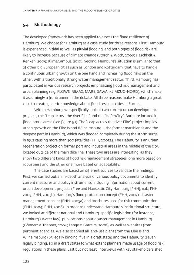
Within Hamburg, we specifically look at two current urban development
projects, the “Leap across the river Elbe” and the “HafenCity”. Both are located in
flood prone areas (see figure 5.1). The “Leap across the river Elbe” project implies
urban growth on the Elbe Island Wilhelmsburg – the former marshlands and the
deepest part in Hamburg, which was flooded completely during the storm surge
in 1962 causing more than 300 fatalities (FHH, 2005a). The HafenCity is an urban
regeneration project on former port and industrial areas in the middle of the city,
located outside of the main dike line. These two areas are interesting, as they
show two different kinds of flood risk management strategies, one more based on
robustness and the other one more based on adaptability.
The case studies are based on different sources to validate the findings.
First, we carried out an in-depth analysis of various policy documents to identify
current measures and policy instruments, including information about current
urban development projects (Free and Hanseatic City Hamburg [FHH], n.d.; FHH,
management concept (FHH, 2005a) and brochures used for risk communication
(FHH, 2004; FHH, 2008). In order to understand Hamburg’s institutional structure,
we looked at different national and Hamburg-specific legislation (for instance,
Hamburg’s water law), publications about disaster management in Hamburg
(Gönnert & Triebner, 2004; Lange & Garrelts, 2008), as well as websites from
pertinent agencies. We also scanned all land-use plans from the Elbe Island
Wilhelmsburg (65 legally binding, five in a draft state) and the HafenCity (seven
legally binding, six in a draft state) to what extent planners made usage of flood risk
regulations in these plans. Last but not least, interviews with key stakeholders shed
CHAPTER 5 A FRAMEWORK FOR ASSESSING THE FLOOD RESILIENCE OF CITIES
129
Figure 5.1: Locations of the HafenCity and the Elbe Island Wilhelmsburg, the thick line representing Hamburg’s dike line. Source: designed by author; Basemap from ESRI OpenSource.
light on the process of the two urban development projects, revealing which
capacities played a role and why certain solutions were favoured above others. In
total, we interviewed 8 stakeholders, comprising planners, water managers, disaster
managers, researchers as well as citizens. On a ministerial level, the governmental
stakeholders come from the BSU (Ministry of Urban Development and Environment),
LSBG (the operating water management authority) as well as BIS (Ministry of
the Interior and Sports). On a district level, we spoke to representatives from the
Bezirksamt Mitte, as they are responsible for both urban development projects from
a planning as well as a disaster management perspective. Moreover, we spoke to a
researcher involved in various research projects that try to embed a more resilience-
oriented flood protection in Hamburg and a citizen of the HafenCity, who is at
the same time the “Flutschutzbeauftragter” of his building, which means that he is
responsible for operating the flood gates in case of a storm surge.
5.5 Case study: Hamburg – A flood resilient city?
The “Leap across the river Elbe” and the HafenCity are the two biggest urban
development projects in Hamburg at the moment. The main idea of the “Leap across
the river Elbe” project is to grow in the middle of the city and connect Hamburg’s city
CHAPTER 5 A FRAMEWORK FOR ASSESSING THE FLOOD RESILIENCE OF CITIES
130
parts north and south of the Elbe. This implies new residential and commercial areas
on the Elbe Islands (FHH, 2003; FHH, 2005b). The prognoses vary between 15,000
and 50,000 new citizens that will be allocated in the marshlands. Currently, there
are 50,000 people living on the Elbe Island, so the implementation of the project
could even imply a doubling of today’s population. The HafenCity can be seen as the
first stepping stone of the project, as it brings the inner city closer to the river Elbe.
On 157 hectares of former port and industrial areas, more than 6,000 homes and
45,000 new jobs are supposed to be created (HCH, 2014). Thereby the inner city
can be expanded by 40%. The goal is to create an attractive waterfront and a lively
neighbourhood with retail, residential areas and office space.
“Leap across the Elbe” – Urban redevelopment on the Elbe island Wilhelmsburg
Content – measures and policy instruments applied to lower flood risk
Like the rest of Hamburg, the Elbe Island Wilhelmsburg is protected by a main dike
line that gets continuously heightened and strengthened. The newest program for
dike renewal, the so-called “Bauprogramm Hochwasserschutz”, dates back to 2007 and
prescribes on average an elevation of 1m (FHH, 2007). The program ends in 2016.
However, more elevations can be expected, as the design level for floods has been
increased by another 80cm in 2012, among others due to the projected sea level rise.
Although the dikes get higher and higher, Hamburg also attempts to be prepared for
the case that a storm surge overtops the main dike line. For this purpose, detailed
warning and evacuation schemes exist. The need for such schemes became obvious
after a disastrous storm surge in 1962 when one sixth of the whole city was flooded,
20.000 people had to be evacuated and 300 people died (FHH, 2005a).
The population is informed about these schemes by so-called “Sturmflut-
Merkblätter” (storm surge information sheets), that are distributed yearly among all
concerned households. The storm surge information sheets vary per district, and
apart from German they are disseminated in five foreign languages (Polish, Turkish,
Serbo-Croatian, English, and Russian) to make sure that everyone can understand
the provided information. They include advice for individuals and a list of important
telephone numbers whom to contact in case of a storm surge. The second page
of the information sheet is always a map of the district indicating the safe areas,
areas that will be warned and areas that will possibly be evacuated. It also includes
emergency shelters and bus stops that serve as meeting points in case of evacuation.
In recent years, two ideas were developed trying to create synergies between
flood risk management and urban planning on the Elbe island: a ‘compartment
CHAPTER 5 A FRAMEWORK FOR ASSESSING THE FLOOD RESILIENCE OF CITIES
131
system’ and a ‘dike park’. Whereas the idea for a compartment system was
developed by researchers from the Technical University of Hamburg within
the research project RIMAX in 2007, the idea for a dike park was created by
a consultancy firm in 2011 within the context of an International Architecture
Exhibition taking place in Hamburg.
Although both ideas open up opportunities for “living with water”, the
compartment system would have implied a much more radical social and
physical transformation than the dike park. It is based on the idea that different
compartments are created by building dike rings instead of one dike line. The
possibility of flooding would vary from compartment to compartment, so that
there is a smoother transition between water and land. That also means that in
some compartments more adaptation measures are needed than in others. The
compartment system would be designed in such a way that most vulnerable areas
have the lowest chance of being flooded (IBA Hamburg GmbH, 2009; Pasche, 2007;
Helmholtz-Zentrum Potsdam, 2009). The dike park, in turn, works with the existing
dike line. The goal is to make the dike more accessible for the public by seeing dike
investments not only as a chance to maintain and heighten the dike, but also to
create more open spaces at the waterfront, thereby improving the quality of life in
the city (IBA Hamburg GmbH, 2011).
When the compartment system was introduced, it was rejected by policy-
and decision-makers. According to the head of the department water management
at the BSU, the compartment system will also not be part of Hamburg’s future plans.
A researcher involved in the project explains:
Back then, the idea was considered to be inadequate. […] Many people did not
understand that the goal was to lower flood risk and offer chances for urban planning
at the same time. […] that they would still be protected – but according to the concept
of resilience, not resistance. Most people still associate flood protection with huge
walls. However, smooth transitions between water and city are better since they also
improve the risk awareness among the population.
Interestingly, the dike park project has partly been realized. When a piece of the dike
line, the “Klütjenfelder Hauptdeich”, had to be renewed anyways, stairs were included
in the dike to make the waterfront more accessible. However, the dike park does not
imply a real transformation: the flood risk management strategy of the Elbe Island
Wilhelmsburg is still mainly built on the idea of robustness. The hinterland is not
physically prepared for flooding, but disaster management arrangements are in place
to lower the damage in case of a storm surge.
CHAPTER 5 A FRAMEWORK FOR ASSESSING THE FLOOD RESILIENCE OF CITIES
132
Context – institutional structure and legislation
The choice of these measures and the rejection of others can partly be explained
with the institutional structure. After the storm surge of 1962, flood risk
management as well as disaster management have become high priority policy
fields. In case of emergency, the Ministry of the Interior becomes the central disaster
management institution that can instruct all other authorities. In that case, the privy
council of the Ministry of Interior leads the disaster management organisation. He is
even authorised to make decisions without the Senate then, which is normally not
possible in Hamburg. This exemption allows urgent decisions like a ban on driving
on specific roads to be made immediately and with little bureaucracy (FHH, 2005a;
Lange & Garrelts, 2008; Gönnert & Triebner, 2004).
Using spatial planning to lower the potential damage is not yet common
practice. This shows for example in the fact that the “Leap across the Elbe” policy
documents (FHH, 2003, 2005b) published by the planning authority do not include
any statement about flood risk management. Moreover, our analysis of all land-use
plans from the Elbe island (65 legally binding plans, five in a draft version5 ) reveals
that only four plans prescribe measures with respect to flood risk. Land-use plan
Wilhelmsburg 71 from 1994 forbids basements, Wilhelmsburg 2 from 1964 only allows
constructing if the whole parcel is elevated up to a minimum of 2.5m above mean
sea level. While Wilhelmsburg 18 and Wilhelmsburg 72, both from 1994, prescribe a
fixed staircase to a permanently accessible level on 6m above mean sea level, if the
building includes residential use. As legal changes in 2005 require flood risk to be
considered as one concern that has to be balanced with other concerns in the act
of plan-making (§1 VI no. 11 BauGB6 ), one would expect more regulations in recent
land-use plans. While they do include more measures to deal with precipitation,
for example greening roofs, there are no explicit building restrictions because of
storm surges. Although projects like the dike park work on improving the relations
between water managers and planners, the collaboration between both disciplines is
overall still limited.
Process – intellectual, social and political capital
The currently available intellectual, social and political capitals offer another
explanation why a transformation from “fighting the water” to “living with the
water” seems to be so difficult. On the one hand, Hamburg possesses capacities that
support the current strategy. For example, Hamburg has high trust in the expert
knowledge of water engineers. On a symposium dealing with water challenges
5) All land-use plans are publicly accessible on http://www.hamburg.de/bebauungsplaene-online/.
6) BauGB, short for Baugesetzbuch, is the German federal building code.
CHAPTER 5 A FRAMEWORK FOR ASSESSING THE FLOOD RESILIENCE OF CITIES
133
and climate change the former privy council of the BSU praises Hamburg’s “high
competencies in water engineering and flood control” (IBA Hamburg GmbH, 2009,
p. 7). Preventing another disaster like the storm surge of 1962 has a high priority
among policy and decision-makers. Therefore, they are also willing to spend much
public money on flood protection. The latest dike renewal programme costs more
than 600 million €, although partly covered by the Federal Government of Germany.
In a ranking comparing different budget groups within the Ministry of Urban
Development and Environment for the years 2013 and 2014, water management and
flood protection score the 2nd position after housing. A fifth of the overall budget
is spent on water management and flood protection. It has significantly more
resources than urban planning, environmental or climate protection (FHH, 2012).
Experiences with the dike park, however, raise the question how money is
spent and if the integration of urban planning and flood protection legitimizes extra
costs. The integration of stairs into the Klütjenfelder Hauptdeich as a means to make
it a multifunctional dike was more expensive than a normal dike renewal. Moreover,
maintenance costs of the dike have increased because of the intense usage.
A representative of the LSBG therefore states: “If urban planning and flood
protection do something together, the city has to recognize, that this causes extra
costs. You don’t get it for free. However, that often does not work out.” In the
particular case of the Klütjenfelder Hauptdeich, the initial extra costs were covered
by the International Architecture Exhibition. As this is only a temporary budget,
it remains doubtful if other projects like this will also receive funding. In particular,
as some water managers perceive that the multi-functionality of a dike goes at
the expense of its safety. A water manager from the LSBG remarked: “I know a lot
of colleagues of mine that say ‘We want a dike as dike and at best fenced, so that
no one has access to it, because this is our task’.” This may also explain why the
compartment system was rejected. In general, a researcher from TUHH stated:
There is still a rather low openness towards new ideas [...]. The reasons are manifold,
mainly reflecting the “entrapment effect”, i.e. the reluctance to change the current
‘known’ practices and accept something ‘new’ and as such ‘unknown’. There is much
concern about how those changes would fit into the existing legal frameworks and the
internal rules and responsibilities established within and between institutions.
Moving towards a more holistic resilience approach more based on the ideas of
adaptability and transformability is not only difficult for public stakeholders, but
also the broader population. Although national as well as Hamburg legislation
acknowledges that flood risk management is not only a state’s task, but also requires
CHAPTER 5 A FRAMEWORK FOR ASSESSING THE FLOOD RESILIENCE OF CITIES
134
individuals to take necessary precautions within their means (§52 no. 2 HWaG), only
few people are willing to do so. Two different studies about the risk awareness in
Hamburg’s society (Heinrichs & Grunenberg, 2009; Knieling et al., 2009, the latter
specifically about risk awareness on the Elbe island) come to the conclusion that
most people are actually aware of the flood risk, but that the awareness does not
translate into taking own precautionary measures. A practitioner from the BSU
doubts a high risk perception among the population. He explains: “The topic water
has only little meaning for the people. […] People don’t feel concerned. […] Especially
new citizens have no risk perception at all”.
For the same interviewee, the low awareness for flood risk is also a reason
why it is so difficult to achieve public participation:
During a research project, we made an advertisement in the local newspaper
‘Hamburger Abendblatt’ that we are looking for people interested in participating
in flood protection. The newspaper is read by more than 700000 people, 13 people
answered, in the end 7 participated, all of them having already experienced a flood
event.
All in all, although ideas for changing the flood protection scheme of the Elbe Island
exist, public as well as private stakeholders are reluctant to move from a robustness
strategy towards a more adaptable approach. A transformation in future is not
impossible, but barely in sight at the moment. This is mainly due to a lack of social
and political capital. The question therefore arises what makes the HafenCity
different and why was a more adaptable approach realized here?
The HafenCity – Urban regeneration in the heart of the city
Content – measures and policy instruments applied to reduce flood risk
Originally, the areas of the HafenCity lay not only outside the dike line, but they
were also rather low: the height varied between 4.4 – 7.2 m above mean sea level
rise, which means that most parts would get regularly flooded. When the idea of the
HafenCity was born, two possible solutions to deal with flood risk were discussed:
the ‘polder solution’ and the ‘dwelling mound solution’. Whereas the first solution
would imply a protection line of 4.75 km and at least 5 flood barriers, the second
solution required an elevation to a minimum height of 7.5 m above mean sea level
rise. This level is considered flood-proof as it resembles the height of the flood wall
protecting the inner city. Hamburg chose for the urban dwelling mounds, because it
CHAPTER 5 A FRAMEWORK FOR ASSESSING THE FLOOD RESILIENCE OF CITIES
135
CHAPTER 5 A FRAMEWORK FOR ASSESSING THE FLOOD RESILIENCE OF CITIES
Figu
re 5
.2: F
lood
pro
tect
ion
conc
ept
of t
he H
afen
Cit
y. S
ourc
e: H
afen
Cit
y H
ambu
rg G
mbH
, tra
nsla
ted
by a
utho
r.
136
was considered cheaper and it meant that they could start developing much earlier
and step-by-step. With the first solution, developing could have only started when
all flood walls and barriers would have been finalized (Bürgerschaft der Freien und
Hansestadt Hamburg, Drucksache 15/7460, 1997).
Figure 5.2 shows the flood protection concept for the HafenCity. The
dwelling mound solution means that bridges and streets are indeed elevated up to
a minimum of 7.5 m, whereas buildings incorporate the dwelling mound in form of
a basement (see figure 5.3 and 5.4). Some of the basements are designed as parking
garages, others are used as shops. In case of a storm surge, all openings such as
windows are protected by temporarily installable flood gates (FHH, n.d.).
The disaster management arrangement is similar to that of the Elbe Island
Wilhelmsburg. The HafenCity also has storm surge information sheets to inform the
residents about storm surge related risks. Two streets are built higher to serve as
evacuation roads in case of a high storm surge.
Context
The broader historic and economic context further motivates the choice for a quick
development and hence the dwelling mound solution. The reunion of Germany
in 1989 moved Hamburg from a marginal location to the middle of Germany
and a bigger Europe. Already in the 1990s, the development of the HafenCity
was considered an important project to position Hamburg as an economically
viable harbour city in the core of Europe (Bürgerschaft der Freien und Hansestadt
Hamburg, Drucksache 15/7460, 1997).
Before the dwelling mound solution could be realized, legal changes
were necessary. Hamburg’s harbour law had to be changed so that the Senate
could convert areas of the HafenCity from harbour usage into a mixed urban
neighbourhood. Hamburg’s land use plan had to be changed accordingly. Moreover,
a completely new act, the so-called Flutschutzverordnung, had to be passed by the
Senate to allow living in the HafenCity. The HafenCity is now an exemption, as § 63
Abs. 1 HWaG usually prohibits living in areas outside of the main dike line.
Apart from legal changes, the HafenCity also establishes a new institution to
operate the flood gates within the buildings, the so-called Flutschutzgemeinschaften.
All property owners within a building complex are automatically part of it. Every
Flutschutzgemeinschaft has a Flutschutzbeauftragter who is the main contact person
and responsible for putting the flood gates in place, when a storm surge is expected.
To conclude, the HafenCity brought about various institutional changes and
innovations as well as capacity-building.
CHAPTER 5 A FRAMEWORK FOR ASSESSING THE FLOOD RESILIENCE OF CITIES
137
CHAPTER 5 A FRAMEWORK FOR ASSESSING THE FLOOD RESILIENCE OF CITIES
Figure 5.4: Basements of buildings during a storm surge in 2007. Source: ELBE&FLUT/Thomas Happel.
Figure 5.3: Basements of buildings, usual situation. Source: ELBE&FLUT/Thomas Happel.
138
Process
First of all, the urban dwelling mound solution shows high intellectual capital. The
flood protection concept of the HafenCity is often praised for being very innovative.
Indeed, Hamburg’s water managers translated a concept that they have already
used in the harbour area for years to the context of a mixed urban quarter. In the
harbour area, it is common practice that property owners form Poldergemeinschaften
that cover the costs for constructing, operating and maintaining flood protection
schemes.
In the case of the HafenCity, private stakeholders cover the costs for
constructing, operating and maintaining the basements as well as the flood gates,
whereas public money is spent on elevating the whole area and building evacuation
roads. As this is not a common agreement for residential areas, the question is why
private developers accepted these conditions. One private developer explained his
motives to live and work in the HafenCity:
It’s the location. Working at the waterfront increases the productivity of your
employees by at least 25%, you can feel that. Where can you find a nicer location than
here, where you have a direct view on the river Elbe, a view on the cruise liners? Just
this morning a cruise liner has again arrived. It is just a preferred location.
Apparently, living at the waterfront makes up for extra costs. Of course, it also
requires the financial capacity among private stakeholders. As Menzl (2010) points
out, the HafenCity is one of the highest-price areas in Hamburg, for renters and
buyers alike. It can therefore be assumed people living in the HafenCity have the
financial capacity to cover these costs. Interestingly, our interviewee doubted that
the flood protection scheme leads to a higher civil awareness among residents:
To be honest, people here are rarely aware of flood risk. Of course it is visible, for
example the storm surge last year December, but the HafenCity is safe. What I always
say: If we are flooded here, the rest is already.
Hence the willingness to invest into flood protection seems less driven by flood risk
awareness or the idea of being ‘resilient’ than the location.
Similarly, public stakeholders did not opt for the flood protection concept
because it was more flood resilient, but because it was politically wanted to develop
as quickly as possible. The idea to develop a mixed quarter – first uttered by the
Chief Planning Officer – was taken over by the mayor during the 1990s and even
became a main issue of the mayor’s election campaign in 1997, as an interviewee
CHAPTER 5 A FRAMEWORK FOR ASSESSING THE FLOOD RESILIENCE OF CITIES
139
from the BSU explains. The political priority of the project is also expressed in the
fact that the HafenCity got its own development agency, the HafenCity GmbH.
Because of the strong political will, legal changes as described in the previous
section became possible. Some documents (e.g. FHH, n.d. and the master plan of the
HafenCity) promote that the HafenCity might be included in the main dike line by
installing flood barrages and flood walls at a later stage. This shows that the flood
protection scheme was not about resilience per se, but instead a means towards a
purely economic and political end: positing Hamburg as a harbour metropolis within
Europe as quickly as possible.
5.6 Conclusions
This paper set out to develop a framework for assessing the flood resilience of cities,
for scientists and policy- and decision-makers alike. The framework presented is
a heuristic one made for qualitative assessment. It enriches the current literature
on flood resilience in two ways. First, the framework overcomes the resistance–
resilience dichotomy often used in flood risk management (De Bruijn, 2005; Douven
et al., 2012; Hooijer et al., 2004; Vis et al., 2003). The paper argues that technical
measures usually attributed to a “resistance strategy” are not contradictory to a
resilience strategy, because robustness and the ability to withstand a flood event are
inherent characteristics of resilience itself (Holling, 1973; Davoudi et al., 2012; Scott,
2013; Galderisi et al., 2010). Second, it clarifies resilience and the meaning of its three
key characteristics – robustness, adaptability and transformability – for the specific
context of flooding in cities. By identifying important components for implementing
resilience strategies, the paper goes beyond predominantly conceptualizing resilience
(e.g. Pendall et al., 2010; Davoudi et al., 2012; Alexander, 2013). These components
comprise content, context and process factors for decreasing flood probability,
reducing consequences of flooding and fostering societal change (see Figure 5.1).
The focus on strategies gives the resilience concept a new notion compared to the
original ecological meaning – it is no longer descriptive, but a normative concept
that can actively be achieved through intervention.
While the framework is derived from a literature review in this field, the two
case studies from Hamburg add important practical insights into both the current
barriers to implementing a resilience strategy and the chances to achieve such a
strategy. The first case – the Elbe island of Wilhelmsburg – shows that building
up social and political capital remains one of the main challenges to moving to a
holistic resilience approach. This includes a better integration of urban planning and
CHAPTER 5 A FRAMEWORK FOR ASSESSING THE FLOOD RESILIENCE OF CITIES
140
water management as well as the willingness of private developers and citizens
to contribute to flood risk management. Raising awareness among both public
as well as private stakeholders is therefore key to making a shift to more resilient
approaches likely in future. For this purpose, the framework suggests measures for
capacity-building; such as consensus-building practices and decision support tools
among public stakeholders, as well as public campaigns and early education in school
among private stakeholders. The HafenCity teaches us another important lesson
in this respect: spatial transformation processes offer the chance to embed flood
resilience into a bigger urban agenda. While flood resilience alone is not enough
motivation to change the flood risk management strategy, it has the potential to link
into a broader political and economic agenda and thereby create win-win situations.
Moreover, political capital is extremely important in the shift towards a resilience
strategy. Leadership and key agents, as in this case the mayor, made lots of legal
changes possible. Moreover, the location convinced private developers to invest
in the area, even though they had to carry the costs for flood protection.
Overall, we conclude with three suggestions for urban policy and research:
The example of the HafenCity shows, however, that resilience is not more costly
per se. The financial aspect again strengthens the need to create synergies with
other fields: flood resilience should not be a separate policy, but integrated into
a broader urban agenda.
CHAPTER 5 A FRAMEWORK FOR ASSESSING THE FLOOD RESILIENCE OF CITIES
142
References
Alexander, D. E., 2013. Resilience and disaster risk reduction: an etymological journey. Natural Hazards and Earth Systems Sciences Discussions, 1, 1257-1284. doi:10.5194/nhess-13-2707-2013
Bürgerschaft der Freien und Hansestadt Hamburg, 1997. Hamburg’s Standort- und Hafenentwicklung im 21. Jahrhundert. Drucksache 15/7460. Hamburg, 16p.
Daschkeit, A. & Renken, A.L., 2006. Klimaänderung und Klimafolgen in Hamburg – Fachlicher Orientierungsrahmen, 38p. Retrieved from http://www.hamburg.de/contentblob/3956444/data/orientierungsrahmen.pdf, accessed on 27 September 2013.
Davoudi, S., 2012. Resilience: A bridging concept or a dead end?, Planning Theory and Practice, 13, 299-307. doi: 10.1080/14649357.2012.677124
De Bruijn, K.M., 2005. Resilience and flood risk management – a system’s approach applied to lowland rivers (Doctoral dissertation). Technical University of Delft, Delft.
Douven, W., Buurman, J., Beevers, L., Verheij, H., Goichot, M., Nguyen, N.A., Truong, H.T., & Ngoc, H.M., 2012. Resistance versus resilience approaches in road planning and Design in delta areas: Mekong floodplains in Cambodia and Vietnam. Journal of Environmental Planning and Management, 55, 1289-1310. doi:10.1080/09640568.2011.644848
FHH (Ed.), n.d. Informationen zum Flutschutz im Bereich der HafenCity Hamburg , [Information about flood protection in the HafenCity Hamburg], 1–5. Hamburg: BSU.
FHH (Ed.). (2003). Sprung über die Elbe [Leap across the Elbe], published by BSU, Hamburg, 72p.
FHH (Ed.). (2004). Elvis und Bär unterwegs – Hochwasserschutz in Hamburg [Elvis and Ba¨r on the road–flood protection in Hamburg], 1–28. Hamburg: BSU.
FHH (Ed.). (2005a). Katastrophenschutz in Hamburg – für Hamburg [Disaster management in Hamburg–for Hamburg], 1–17. Hamburg: BIS.
FHH (Ed.). (2005b). Sprung über die Elbe – Hamburg auf dem Weg zur internationalen Bauausstellung – IBA 2013 [Leap across the Elbe – Hamburg on its way to the International Architecture Exhibition – IBA 2013], 1–94. Hamburg: BSU.
FHH (Ed.). (2007). Hochwasserschutz in Hamburg – Bauprogramm 2007 [Flood protection in Hamburg – building programme 2007], 1–18. Hamburg: LSBG.
FHH (Ed.). (2008). Sturmflutschutz in Hamburg – für Hamburg: Tipps und Hinweise für den Sturmflut- Und Hochwasserfall [Storm surge protection in Hamburg – for Hamburg: Tips and Hints for a storm surge or flood situation], 1–15. Hamburg: BIS.
FHH (Ed.). (2012). Haushaltsplan 2013/2014 – Einzelplan 6 Behörde für Stadtentwicklung und Umwelt [Budget plan 2013/2014 of the Ministry of Urban Development and Environment], Hamburg: BSU. Retrieved from http://www.hamburg.de/contentblob/3540268/data/einzelplan-6-0.pdf, accessed on 27 August 2014.
Folke, C.; Carpenter, S.R.; Walker, B.; Scheffer, M.; Chapin, T.; & Rockström, J., 2010. Resilience Thinking: Integrating Resilience, Adaptability and Transformability. Ecology and Society, 15(4): 20.
Galderisi, A., Ferrara, F.F., & Ceudech, A., 2010. Resilience and/or vulnerability? Relationships and roles in risk mitigation strategies. Paper presented at the 24th AESOP annual conference. Helsinki.
CHAPTER 5 A FRAMEWORK FOR ASSESSING THE FLOOD RESILIENCE OF CITIES
Gönnert, G. & Triebner, J., 2004. Hochwasserschutz in Hamburg [Coastal Protection in Hamburg]. In: Schernewski G. and Dolch T. (Eds.), Geographie der Meere und Küsten, Coastline Reports, 1, 119-126. ISSN 0928-2734.
Green, J.J., Kleiner, A.M., & Montgomery, J.P. (2007). The texture of local disaster response: service provider’s views following Hurricane Katrina. Southern Rural Sociology 22(2), 28-44.
Gupta, J., Termeer, C,. Klostermann, J., Meijerink, S. Brink, M. van den, Jong, P., Nooteboom, S. & Bergsma, E., 2010. The Adaptive Capacity Wheel: a method to assess the inherent characteristics of institutions to enable the adaptive capacity of society. Environmental Science & Policy, 13(6), pp.459–471. doi: 10.1016/j.envsci.2010.05.006
Healey, P., 1997. Building institutional capacity through collaborative approaches to urban planning. Environment and Planning A, 30, 1531-1546.
Healey, P., Khakee, A., Motte, A. & Needham, B., 1999. European Developments in Strategic Spatial Planning, European Planning Studies, 7, 339-355.
Heinrichs, H., & Grunenberg, H. (2009). Klimawandel und Gesellschaft: Perspektive Adaptionskommunikation [Climate change and society: perspective adaptation communication]. Wiesbaden: VS Verlag für Sozialwissenschaften GmbH.
Helmholtz-Zentrum Potsdam (Ed.), 2009. RIMAX – Risikomanagement extremer Hochwasserereignisse: Ergebnisse aus der Hochwasserforschung [RIMAX – Risk management of extreme flood events: Results of the flood reseach]. Potsdam: Brandenburgische Universitätsdruckerei. Retrieved from http://www.fona.de/mediathek/pdf/B_5_1_5_RIMAX_Broschuere_2009.pdf, accessed on 27 September 2013.
Holling, C.S., 1973. Resilience and stability of ecological systems. Annual Review of Ecology and Systematics, 4, 1-23.
Holling, C.S., 1996. Engineering resilience versus ecological resilience. In: Schulze, P.C. (Ed.), Engineering within ecological constraints (pp. 31-43). Washington, D.C.: National Academy Press.
Hooijer, A., Klijn, F., Pedroli, G., Bas, M. & Os, A. G. van, 2004. Towards sustainable flood risk management in the Rhine and Meuse River Basins: Synopsis of the findings of IRMA-SPONGE, River Research and Applications, 20, 343-357. doi: 10.1002/rra.781
Hutter, G., 2006. Strategies for flood risk management – a process perspective. In: Schanze, J.; Zeman, E. & Marsalek, J. (Eds.), Flood risk management: hazards, vulnerability and mitigation measures (pp. 229 – 246), Dordrecht: Springer.
IBA Hamburg GmbH (Ed.), 2009. IBA-Labor Klimafolgenmanagement: Herausforderung Wasser. Documentation of a symposium taking place 19 – 21 February 2009, Hamburg. Retrieved from http://www.iba-hamburg.de/fileadmin/Mediathek/Buecher/labor_KFM.pdf, accessed on 27 September 2013.
IBA Hamburg GmbH (Ed.), 2011. IBA-Machbarkeitsstudie Deichpark Elbinsel [IBA feasibility study]. Retrieved from: http://www.iba-hamburg.de/fileadmin/Slideshows_post2013/02_Wissen/03_Buecher/Machbarkeitsstudie_DeichparkElbinsel_web_1_.pdf, accessed on 27 September 2013.
Jonkman, S.N., Gelder, P.H.A.J. van & Vrijling, J.K., 2003. An overview of quantitative risk measures for loss of life and economic damage. Journal of Hazardous Materials, 99(1), 1–30. doi:10.1016/S0304-3894(02)00283-2
CHAPTER 5 A FRAMEWORK FOR ASSESSING THE FLOOD RESILIENCE OF CITIES
144
Khakee, A., 2002. Assessing institutional capital building in a local Agenda 21 process in Göteborg, Planning Theory and Practice, 3, 53-68. doi: 10.1080/14649350220117807
Klein, R.J.T., Nicholls, R.J. & Thomalla, F., 2004. Resilience to natural hazards: how useful is this concept? EVA working paper no. 9, DINAS-COAST working paper no. 14, Potsdam Institute for Climate Impact Research, Potsdam.
KlimaCampus, 2010. Klimabericht für die Metropolregion Hamburg – ein Auszug [Climate report for the metropolitan region of Hamburg - an excerpt], Hamburg, 62p. Retrieved from http://www.klimacampus.de/fileadmin/user_upload/klimacampus/1_Dokumente/6_Magazin/klimabericht_booklet.pdf, accessed on 27 September 2013.
Knieling, J., Schaerffer, M. & Tressl, S., 2009. Klimawandel und Raumplanung – Flächen- und Risikomanagement überschwemmungsgefährdeter Gebiete am Beispiel der Hamburger Elbinsel [Climate change and spatial planning — Land use and risk management of flood prone areas exemplified by the Elbe Island Hamburg]. Coastline Reports, 14. Retrieved from http://www.eucc-d.de/coastline-reports-14-2009.html, accessed on 27 September 2013.
Kuhlicke, C. & Steinführer, A., 2013. Searching for resilience or building social capacities for flood risk? Planning Theory and Practice, 14, 114-118. doi: 10.1080/14649357.2012.761904
Lange, H. & Garrelts, H., 2008. Integriertes Hochwasserrisikomanagement in einer individualisierten Gesellschaft (INNIG) [Integrated flood risk management in an individualized society], artec-paper no. 152, Bremen: artec Forschungszentrum Nachhaltigkeit.
Menzl, M., 2010. Reurbanisierung? Zuzugsmotive und lokale Bindungen der neuen Innenstadtbewohner – das Beispiel der HafenCity Hamburg [Reurbanisation? Motives for moving and local ties of the new inner city residents - the example of the HafenCity] . In: Dittrich-Wesbuer, A., Knapp, W. u. Osterhage, F. (Eds.): Post-Suburbanisierung und die Renaissance der Innenstädte – neue Entwicklungen in der Stadtregion, Dortmund: Rohn.
Meijerink, S. and Dicke, W., 2008. Shifts in the Public–Private Divide in Flood Management, International Journal of Water Resources Development, 24, 499-512. doi: 10.1080/07900620801921363
Oosterberg, W., Drimmelen, C. van, & Vlist, M. van der, 2005. Strategies to harmonize urbanization and flood risk management in deltas, European Regional Science Association, Amsterdam. Retrieved from http://www.ersa.org.
Pahl-Wostl, C., 2007. Transitions towards adaptive management of water facing climate and global change. Water Resources Management (21), 49-62. doi: 10.1007/s11269-006-9040-4
Pasche, E., 2007. Risikomanagement statt Hochwasserschutz von Küstenstädten in Zeiten des Klimawandels [Risk management instead of flood protection in coastal cities in times of climate change]. Science Allemagne, 04/2007, 4p.
Pelling, M., 2007. Learning from others: The scope and challenges for participatory disaster risk assessment. Disasters, 31, 373-385. doi: 10.1111/j.1467-7717.2007.01014.x
Pendall, R., Foster, K.A., & Cowell, M., 2010. Resilience and regions: building understanding of the metaphor. Cambridge Journal of Regions, Economy and Society, 3, 71-84. doi: 10.1093/cjres/rsp028
Scott, M., 2013. Living with flood risk. Planning Theory and Practice, 14, 103-106. doi: 10.1080/14649357.2012.761904
Storch, H. von & Woth, K., 2008. Storm surges: perspectives and options. Sustainability Science, 3, 33-43. doi: 10.1007/s11625-008-0044-2
CHAPTER 5 A FRAMEWORK FOR ASSESSING THE FLOOD RESILIENCE OF CITIES
145
Van Herk, S., Zevenbergen, C., Ashley, R. & Rijke, J., 2011. Learning and Action Alliances for the integration of flood risk management into urban planning: a new framework from empirical evidence from The Netherlands. Environmental Science & Policy, 14(5), 543–554. doi: 10.1016/j.envsci.2011.04.006
Vis, M., Klijn, F., Bruijn, K.M. de, & Buuren, M. van, 2003. Resilience strategies for flood risk management in the Netherlands. International Journal of River Basin Management, 1, 33-40. doi: 10.1080/15715124.2003.9635190
Walker, B., Holling, C.S., Carpenter, S.R. & Kinzig, A., 2004. Resilience, Adaptability and Transformability in Social-Ecological Systems. Ecology and Society, 9(2): 5. Retrieved from http://www.ecologyandsociety.org/vol9/iss2/art5/.
White I., 2010. Water and the city: Risk, resilience and planning for a sustainable future. The Natural and Built Environment Series, London and New York: Routledge.
Woltjer, J. & Al, N., 2007. Integrating Water Management and Spatial Planning – Strategies based on the Dutch Experience. Journal of the American Planning Association, 73, 211-222. doi: 10.1080/01944360708976154
Zevenbergen, C., Veerbeek, W., Gersonius, B. & Herk, S. van, 2008. Challenges in urban flood management: travelling across spatial and temporal scales, Journal of Flood Risk Management, 1, 81-88. doi: 10.1111/j.1753-318X.2008.00010.x
CHAPTER 5 A FRAMEWORK FOR ASSESSING THE FLOOD RESILIENCE OF CITIES