UNIVERSITY OF NOVA GORICA GRADUATE SCHOOL UNIVERSITY IUAV OF VENICE THE BRIDGE OF THE VISCONTI FAMILY IN VALEGGIO SUL MINCIO: FROM PRESERVATION TO MAINTENANCE FOR A SAFEGUARD STRATEGY II. LEVEL MASTER'S THESIS Giorgia Strabbioli Mentor/s: Prof. Ing. Arch. Paolo Faccio Venice, 2006/2007
Transcript
UNIVERSITY OF NOVA GORICA GRADUATE SCHOOL
UNIVERSITY IUAV OF VENICE
THE BRIDGE OF THE VISCONTI FAMILY IN VALEGGIO
SUL MINCIO: FROM PRESERVATION TO MAINTENANCE
FOR A SAFEGUARD STRATEGY
II. LEVEL MASTER'S THESIS
Giorgia Strabbioli
Mentor/s: Prof. Ing. Arch. Paolo Faccio
Venice, 2006/2007
2
AIMS AND CRITERIA
1. THE MINCIO VALLEY DURING THE VISCONTIS' RULE
1.1 The territory between the past and the present
1.2 The Mincio river and the morainic amphitheatre
1.3 The fortification: a construction in symbiosis with the character of the places
1.4 The Viscontis’rule: the territory as an experience laboratory for fortified
architecture
1.5 The bridge-dam of Valeggio sul Mincio: a medieval construction, a modern
conception building
FIRST PART BIBLIOGRAPHY
2. THE KNOWLEDGE OF THE BUILDING
2.1 The methodology of surveying a historical building
2.2 The bridge’s constructive history and the places’ seismic events
2.3 The geometric survey of the building and its present dimensions
2.4 The preservation status and the survey of the material damage
2.5 The evaluation of the Visconti bridge safety limits
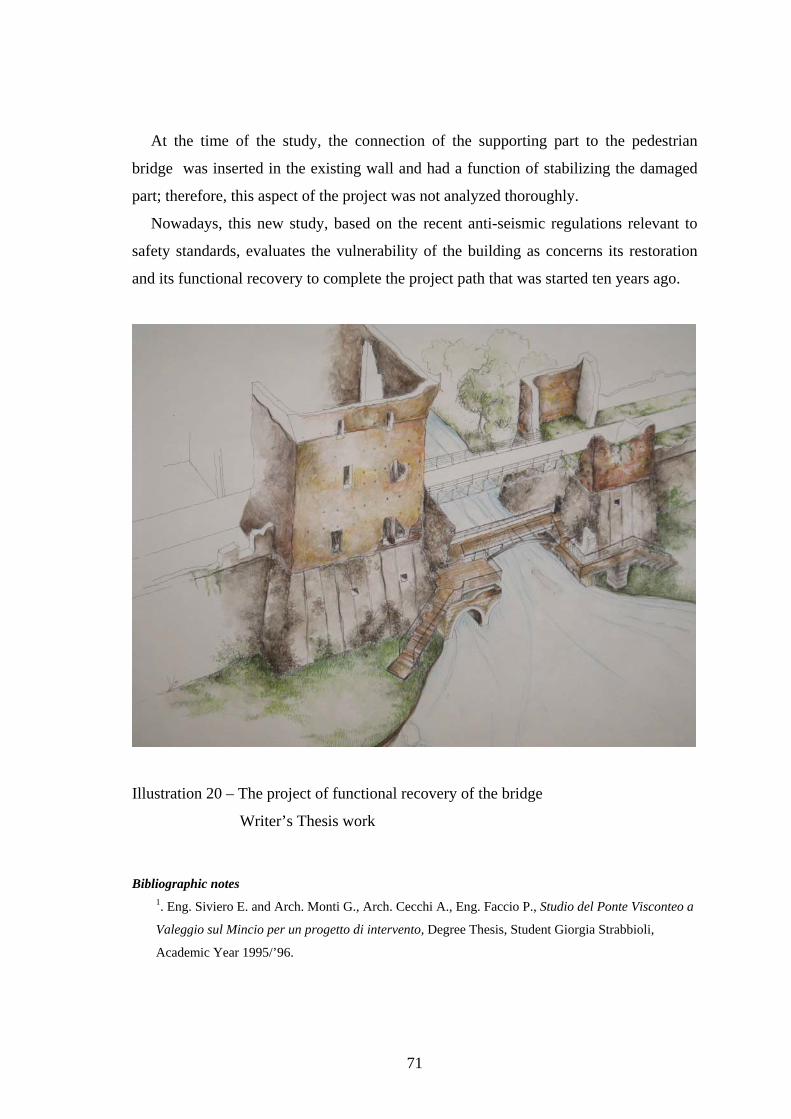
2.6 The pilot project: a safeguard strategy
2.7 The techniques of intervention of consolidation
2.8 The monitoring as a control program for the preservation of the architectonic
structure
2.9 The functional recovery of the Visconti bridge: the urban context as a project key of
the intervention
SECOND PART BIBLIOGRAPHY
3
AIMS AND CRITERIA
Nowadays, we realize the importance of our historical-artistic heritage only when a
dramatic event occurs and it deprives irremediably us of a part of a historical conscience
that is the fundamental element of the unity of a people.
However, the loss of a monument is never a sudden and inexplicable action: the
ancient construction, designed according to the Vitruvian triad of firmitas, utilitas,
venustas, always gives warning signs of its conditions.
But the correct preservation of cultural inheritance also depends on the nature of the
projects that are made for it.
These projects often come from the wrong and dangerous idea that the only possible
operation is to consolidate the existing construction by using building methods of
modern conception.
The recent regulations relevant to the seismic issue have raised, instead, the need to
use suitable instruments to intervene on the monument with a methodologically correct
process, combining the undelayable necessities to achieve high levels of safety with the
need to protect the monument itself.
The case study of the Visconti Bridge in Valeggio sul Mincio, an extraordinary
example of hydraulic engineering and military architecture of the late Middle Ages,
translates, on the operational plan, the need for an urgent restoration project based on
minimum intervention and putting of the construction into safety according to the
all’OPCM 3274/03 1 and its following modifications and integrations, while also verifying the
contents of the ‹‹ Linee Guida per la valutazione e riduzione del rischio sismico del
patrimonio culturale con riferimento alle norme tecniche per le costruzioni›› 2 [ Transl. ‹‹
Guidelines for the assessment and reduction of the seismic risk of the cultural inheritance with
reference to the technical regulations for construction ››.
The project includes the definitions of a way of analysis and a cognitive survey of the
construction.
Bibliographic notes 1. Ordinanza Presidenza del Consiglio dei Ministri, No 3274/ del 20 Marzo 2003.
4
2. Ministry for the Cultural Heritage. Department for Cultural Heritage and Landscapes. General
Direction for Architectonic Heritage and Landscapes. Linee Guida per la valutazione e riduzione del
rischio sismico del patrimonio culturale, Rome, Gangemi Editore, December, 2006.
5
1. THE MINCIO VALLEY DURING THE VISCONTIS' RULE
1.1 THE TERRITORY BETWEEN THE PAST AND THE PRESENT
The municipality of Valeggio sul Mincio rises to the Southwest of Verona, where the
green and flat plain starts leaving space to a sweet hill that characterizes the snout where
Garda Lake is inserted and protected.
This territory, so slightly closed and fortified by the Mincio River that even the poet
Virgil described in his works ‹‹… là in quella terra ove il Mincio, di molli canneti orlato le
rive in lente spire va errando.›› 1 [ Transl.‹‹… there in that land where Mincio, whose banks
are bordered by soft reed-beds wanders in slow coils.››] , has represented a strong point to
Valeggio in the course of its history.
The exceptionality of this place was known since ancient times, when, during the
Bronze Age, an Indo-European community lived on the Mincio, a few kilometers away
from the Borghetto hamlet (a medieval village in Valeggio territory), a palafitte village.
The River was a source of food and protection and so its banks always welcomed
numerous civilizations (Gallic, Etruscan and Romans) until it became, starting from the
Scaligeris’ rule and ending with the Viscontis’ rule, a real defensive war weapon of the
state.
Only in this geographic point of the territory since the Romans times had there been
the unique passage between the Veneto and the Lombardy through the ancient Via
Postumia and Via Gallica, a sort of door for the communications in Northern Italy. And,
in the Middle Ages, the main way connecting the Po Plain with Germany passed
through this territory. This and the particular conformation of the landscape made this
land a nerve centre for several centuries, as well as a strategic place for historical events
that occurred both at national and European level.
Still, nowadays, this historical access represents a crucial point for the
communications in Northern Italy and it is also an instrument to organize the territory.
The transformation of buildings is focused along the roads that start from the centre and
radiate out like a fan.
6
Indeed, in the Encyclopedic Atlas “Touring” 2, Valeggio is quoted as a characteristic
example of this kind of development by defining it as a “development with a bridge at
the centre” since the village is focused on its symbolic monument: the Visconti bridge.
Imposing, exceptional and unique work of hydraulic engineering of the late Middle
Ages in Italy and Northern Europe, the Visconti Bridge, as it is named nowadays (even
if it was designed to operate as a dam), was built on this ancient road and still now
summarizes the exceptionality of this place. The no. 55 Provincial Road Valeggio –
Volta Mantovana, which connects the Veneto Region to the Lombardy Region, passes
on it and reconfirms the importance of the passage to the Northwest that history has
handed down as well as how the bridge has become the distributive element of Valeggio
buildings.
Even now, the peculiar elements of the landscape of the village of Valeggio are the
Mincio river and the stout that are mainly unchanged in their morphology; these natural
elements allowed the realization in 1393 of this architectonic unicum for the territory
defense.
Bibliographic notes 1. Virgilio, Georgiche, book three , lines 14-15. Transl. 2. Atlante Enciclopedico Touring, v. 1- Italia – 1st Edition, Milan C. T. I., 1986, page 17, Map D.
7
1.2 THE MINCIO RIVER AND THE MORAINIC AMPHITEATRE
Important protagonists of the Lake Garda area, where Valeggio is located, are the
Mincio river and the stout.
Speaking of their origins means telling a story that intertwines itself until mixing
itself up and becoming, maybe, all one, inseparable elements in their genesis.
Even if they now look like two different landscapes in the remote post-glacial period,
the configuration of the River and the glacial basin probably originated almost at the
same time.
In fact, during the inter-glacial period, Mindel – Riss, the glaciers that covered the
region of the Alps, started to retract because of the increase in temperature all over
Europe and left a huge quantity of rocky debris in their place that a raging flooding
river, scoring the territory with a large gorge, brought downstream.
The materials that laid down in this phase of terrestrial settlements with a semi-
circular shape (from where the word "amphitheatre" comes from) was named moraine,
whilst the raging avalanche of water and debris was less and less violent and reduced in
its watercourse.
From this new land conformation and the slow draining of water in a course of
limited dimensions, the Mincio River originated.
With a probable Latin root, the Minctio (Mincio) word, with the literal meaning of
drain, can technically be translated as an “outflowing stream”; in fact, it is the only river
coming out from Lake Garda.
Despite its limited dimensions (it is about 75 km long), the River passes through
different natural environments: it outflows majestically from the Lake Garda; with a
winding course, the Mincio longitudinally passes through the glacial rises and crosses
them from the North to the South, passes the sweet unevenness that it meets in the tract
between the Frati Mount and the Ogheri Mount, and then keeps an even course and
reaches the large fan of Valeggio where it builds a series of palaeowatercourses.
In the surroundings of Grazie a Borgoforte (Mantua) where there is the most
important paleowatercourse of Mincio, the River modifies its course and takes a new
direction: West-East.
8
Now it licks a mostly marshy environment with its green water up to the town of
Mantua. There, together with numerous resurgences, it contributes to the formation of
three lakes from which it outflows.
Similar to an artificial canal, the Mincio starts its course again to meet and join the
Po River.
Therefore, the territory where the Mincio passes through is very varied : the sweet
profiles of the glacial hills that gradually descend to the river, passes the rapid slope
with the characteristic trend of a mountain ridge and then the river “gets lost” in the
open plain of Mantua.
If the Po Plain appeals for its infinite space, the stout, especially the Garda one,
shocks for its numerous evidences of the glaciations that stratified on its rocks.
The moraines are accumulations of filling material with a curve conformation 1 of
three different types:
• front moraines;
• side moraines;
• bottom moraines.
In the Garda area, there are the first two types of moraines that give the landscape the
typical conformation of an amphitheatre for their semi-circular shape, which is a kind of
natural basin in an even land.
This rich and complex environmental context has its raison d’être, thanks to the
existence of the Lake Garda.
This is the largest Italian lake that originated its primordial shape during the
Pliocene, in the Tertiary Era, when slow and strong telluric movements made large
limestone masses detach from the Monte Baldo and created the concave shape that
started the transformation defined a lake 2.
Later, in the Quaternary Era, glaciers started their descent to the valley and their
forward movement modified the lake banks and created the typical inlets that edge still
now the lake borders.
Bibliographic notes 1. Azzi Carlo, Il giardino dei ghiacciai, Mantua, Litografia Cannatese, 1994. 2. Gobetti Claudio, Passeggiando lungo il Mincio, Mantua, Grafiche Fabbri, 1993.
9
1.3 THE FORTIFICATION : A CONSTRUCTION IN SYMBIOSIS WITH THE
CHARACTER OF THE PLACES
In a country such as Italy 1, which, in every corner of its territory, can still boast
endless examples of historical architectures that keep, even in the case of the simplest
work, high stylistic and decorative categories, the interest in fortified architecture is
quite recent.
These structures, considered up to a few decades ago only as places of domination,
injustice and torture, were designed, according to such deep structural and spatial
knowledge of the places where they were built, that only few other historical
constructions can be compared to them.
Then, if we add that, thanks to these fortifications, entire populations in the course of
history found a safe shelter from war and devastating plagues, and even that they
allowed the defense of urban centers, we realize why the attention to this architectonic
heritage has been increasing in these most recent years.
The castles, the fortified hamlets and the turreted walls are no longer classified by the
academics only as sinister defense means, but as an organizing element of our territory
that comes from it, uses the materials of the place and becomes an integrating part of the
landscape by strengthening those places, which that were already naturally strategic,
with its structures.
According to this point of view, the defensive system is no longer in contrast with
the environment where it is inserted. Instead, it is an integral part of it.
The case of the Visconti bridge in Valeggio sul Mincio is a demonstration of how
human work blended with the particular conformation of the place.
The place that nature had created - a particular fortified place by a semicircle of
glacial hills, a large water mirror, Garda Lake and its only outflowing stream, the
Mincio River, the Visconti dam-bridge with its typical barrage implant that stresses it in
such a way that it can be considered safe and beautiful over centuries.
Bibliographic notes
1. Perogalli, Ichino and Bazzi, Castelli italiani. Con un repertorio di oltre 4000 architetture
fortificate, Milan, Editrice Bibliografica, 1979.
10
1.4 THE VISCONTIS’ RULE: THE TERRITORY AS AN EXPERIENCE
LABORATORY FOR FORTIFIED ARCHITECTURE
Since the remotest time, when choosing a settling place, every population has always
tried to create defensive structures in order to fight enemy attacks. Yet the simple fence
was an easy, but unmistakable way, to defend a property.
Then, every historical period has elaborated its own fortified architecture that
showed power and, at the same time, could organize society.
In fact, during the Middle Ages, the birth of the urban commune, whose centre often
developed around a castle, led to the creation of independent states with their own
statutes.
Finally, each rule at the end of its own political confirmation has used military work
as an instrument to strengthen the State.
It is during the rule of Gian Galeazzo Visconti (1378-1402) that the expansionist
policy of the Milanese family reached borders never touched before.
However, the family of Milan was always aware that the fortified structure was a
construction to defend themselves from the external threats and, above all, from the
most frightening internal aggressions 1.
Only thanks to large military structures were they able to ensure a methodical
internal unity and a potential external defense.
Moreover, the Viscontis knew that they had to be enterprising builders of fortified
structures in order to be great leaders and powerful rulers of a very large territory.
Thus, their dominations became laboratories of trials for unique experiences.
The works all have huge dimensions and have a common denominator : natural border,
the river and a strategic geographic position to defend.
The centrality of the place and the orographic conformation of the territory are
fundamental basis where resting the new expansionistic policy.
The fortified bridge of Lecco (1336), the covered and fortified bridge of Pavia
(1351), the fortified bridge of Trezzo d’Adda (1377 probable date of completion), the
bridge–dam of Valeggio sul Mincio (1393) and, exactly at the end of the Visconti
domination, the bridge-dam of Bassano del Grappa (1402) were large scale
interventions that allowed to consolidate the rule of the Lords from Milan.
11
Bibliographic notes 1. Vincenti Antonello, I castelli viscontei e la difesa del casato (in) Castelli viscontei e sforzeschi. Series
directed by Carlo Perogalli, Milan, RUSCONI Immagini, 1981, pages 11 – 26.
12
1.5 THE BRIDGE-DAM OF VALEGGIO SUL MINCIO: A MEDIEVAL
CONSTRUCTION, A MODERN CONCEPTION BUILDING YARD
In 1393, the year when the construction of Valeggio sul Mincio began, the Visconti’s
were the masters of the Upper Veneto. The new expansionistic aims of the Milanese
family targeted the Southern part.
The success of this project was certain : Gian Galeazzo Visconti, better than his
predecessors, was aware that the consolidation of the territorial states under the
Viscontis’rule was possible only by an aggressive military policy and the use of
imposing defensive structures designed as war machines.
The alarm in Northern Italy was so high that since 1392, to contain the expansionistic
aims of the Visconti’s, people of Mantua, Este, Modena, Padua, Faenza, Bologna and
Florence set up a League to defend themselves against the invasions of the Milanese
Lords; the union was also supported by Venice, concerned with defending the land just
conquered.
Mantua was the state that, in that period, was mostly under the pressure of the
Viscontis’ ambitious aims.
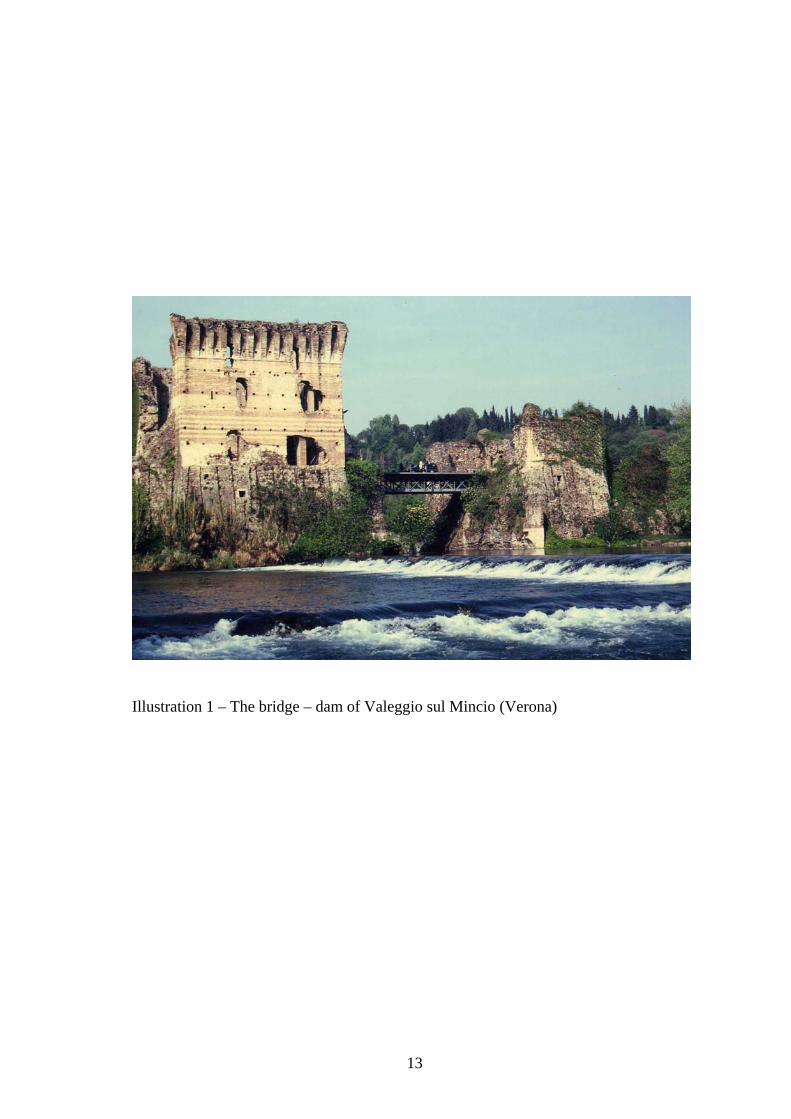
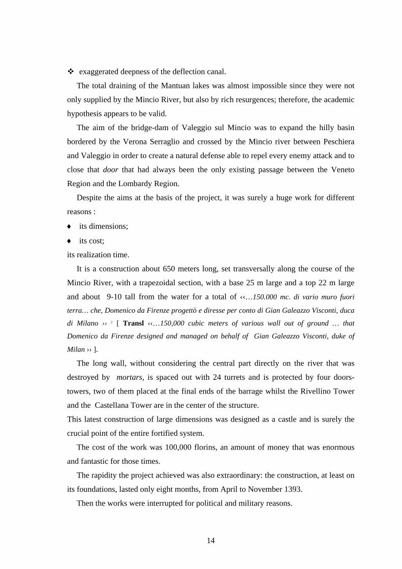
The bridge – dam that the Count of Virtue was having built on the Mincio River in
Valeggio (Ill. 1), at a few steps from the Gonzaga family town, appeared to be able to
neutralize those natural defenses that had always protected these lands.
In fact, Mantua, an island more than a town because it is surrounded by its lakes also
supplied with the waters of the Mincio River, was doubly fortified as regards to other
towns.
The barrage work of the Mincio River, if it had been designed with these aims,
would have deprived Mantua of its natural defenses and would have made it easily
attackable by the troops of Gian Galeazzo Visconti.
According to the studies of Cassi Ramelli 1, who had the merit of having clarified a
few fundamental issues about the real function of the Veronese construction, the aim of
the dam was not to change the Mincio course.
At those times, the work was not possible for several reasons, such as the following :
hardness of the grounds;
great height of the hills;
13
Illustration 1 – The bridge – dam of Valeggio sul Mincio (Verona)
14
exaggerated deepness of the deflection canal.
The total draining of the Mantuan lakes was almost impossible since they were not
only supplied by the Mincio River, but also by rich resurgences; therefore, the academic
hypothesis appears to be valid.
The aim of the bridge-dam of Valeggio sul Mincio was to expand the hilly basin
bordered by the Verona Serraglio and crossed by the Mincio river between Peschiera
and Valeggio in order to create a natural defense able to repel every enemy attack and to
close that door that had always been the only existing passage between the Veneto
Region and the Lombardy Region.
Despite the aims at the basis of the project, it was surely a huge work for different
reasons :
♦ its dimensions;
♦ its cost;
its realization time.
It is a construction about 650 meters long, set transversally along the course of the
Mincio River, with a trapezoidal section, with a base 25 m large and a top 22 m large
and about 9-10 tall from the water for a total of ‹‹…150.000 mc. di vario muro fuori
terra… che, Domenico da Firenze progettò e diresse per conto di Gian Galeazzo Visconti, duca
di Milano ›› 2 [ Transl ‹‹…150,000 cubic meters of various wall out of ground … that
Domenico da Firenze designed and managed on behalf of Gian Galeazzo Visconti, duke of
Milan ›› ].
The long wall, without considering the central part directly on the river that was
destroyed by mortars, is spaced out with 24 turrets and is protected by four doors-
towers, two of them placed at the final ends of the barrage whilst the Rivellino Tower
and the Castellana Tower are in the center of the structure.
This latest construction of large dimensions was designed as a castle and is surely the
crucial point of the entire fortified system.
The cost of the work was 100,000 florins, an amount of money that was enormous
and fantastic for those times.
The rapidity the project achieved was also extraordinary: the construction, at least on
its foundations, lasted only eight months, from April to November 1393.
Then the works were interrupted for political and military reasons.
15
The League, set up in 1392 for the defense against the Viscontis’ war aims, suspended
all works in order to appease the controversies raised among the bordering states and
Milan.
After the interruption of construction, the bridge story had the following destiny :
⇒ from 1393 to about 1397, the construction was forgotten until it started its secondary
function as a bridge, promoted in the Veneto period (1405-1512);
⇒ 1451 is the year when the first repair works of the bridge date back. The Archives
report that the structure was already defined as a bridge;
⇒ 1509-1512 collapse of the central part caused by the Venetians and people from
Valeggio, in opposition to the tradition according to which the Bridge was mined by
French people during their retreat in 1701;
⇒ from 1512 to 1929 the bridge was not used and kept closed of;
⇒ 1929 reopening to traffic with the insertion of a metal girder in the central part of
the historical structure.
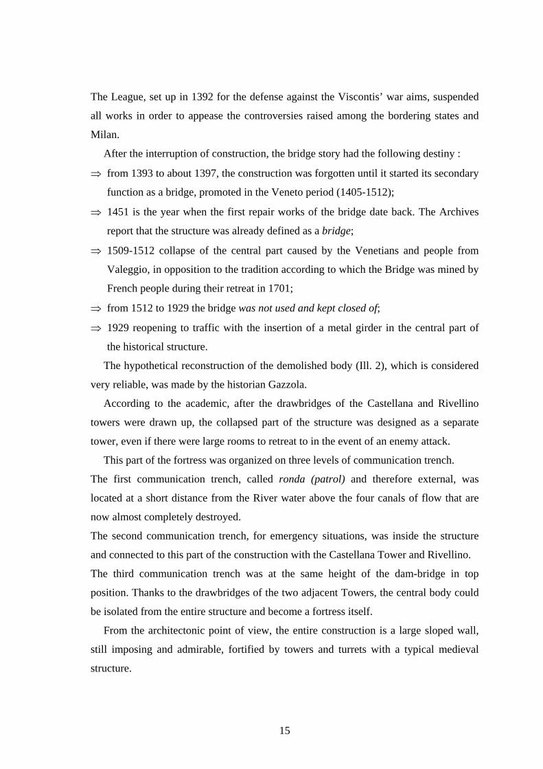
The hypothetical reconstruction of the demolished body (Ill. 2), which is considered
very reliable, was made by the historian Gazzola.
According to the academic, after the drawbridges of the Castellana and Rivellino
towers were drawn up, the collapsed part of the structure was designed as a separate
tower, even if there were large rooms to retreat to in the event of an enemy attack.
This part of the fortress was organized on three levels of communication trench.
The first communication trench, called ronda (patrol) and therefore external, was
located at a short distance from the River water above the four canals of flow that are
now almost completely destroyed.
The second communication trench, for emergency situations, was inside the structure
and connected to this part of the construction with the Castellana Tower and Rivellino.
The third communication trench was at the same height of the dam-bridge in top
position. Thanks to the drawbridges of the two adjacent Towers, the central body could
be isolated from the entire structure and become a fortress itself.
From the architectonic point of view, the entire construction is a large sloped wall,
still imposing and admirable, fortified by towers and turrets with a typical medieval
structure.
16
Illustration 2 – Hypotetical reconstruction of medieval setting up bridge
P. Gazzola, Inventario dei castelli della provincia di Verona – IBI sez.
Italiana 1963, unpublished, sch. I. VR. 89. 5c.
The basement part was realized by a fill-up building technique with a Roman origin
and also studied by Andrea Palladio: wooden tables dug perpendicularly on the ground
where mortar, morainal stones and filling material were laid.
The building method used in this work could be similar to the one that the Architect
Perbellini has hypothesized in his study relevant to this monument 3, that can be
compared to a modern tubular structure made from vertical, horizontal and transversal
elements with the only exception of the used material that is wood.
Therefore, it is a quite simple structure made in a short time that was made in the
following way: a level of works was built, the scaffold was erected and then the second
level of works was carried out and similarly all other phases were performed by
ensuring that the construction work proceeded fast.
This kind of structure was temporary and was useful to building works; as soon as
works were completed, wooden parts were dismantled to be used in another building
yard or they were left at the place until they were naturally destroyed. This was the case
of the Visconti Bridge.
The entire embankment structure and the tower basement were built in the same
period whilst the standing-up part seem to show, also, different moments of working.
17
Nevertheless, different execution phases can correspond to a precise structural
choice.
Presently, only the following assessment can be done: while we see a mainly mixed
masonry at the base (pebble-stones, parts of roof tiles mixed to mortar, such as a kind of
concrete conglomerate), by proceeding to the upper part of the towers, bricks are
prevailing in few points only as coating in others with a continuous section.
Despite the project not being completed because of purely political reasons, the
fortified structure of Valeggio sul Mincio was thought as a barrage on the Mincio River
as well as Viscontis’ castle.
In fact, the Castellana Tower, the only element rising up in the entire construction,
had characteristics similar to a real castle and could be easily separated by the
remaining part of the fortification of drawbridges.
In the Visconti architecture, the Torre Castellana, usually used as a control center,
was much bigger than other towers. In fact, in the case of this fortification, the
dimensions of the plant and of the raised part are characteristics that immediately
impress the visitor.
Such as in a castle, the ground floor was meant to collect machines, food and men of
the presidio; there were the rooms with fireplaces in each room to the upper floors; in
the basements, there are two large vaulted rooms, about twenty meters long, used in
emergency situations.
The stairs had a double function: connecting the floors and making vapors from the
masonry arrangement escape.
This construction method is described by Leon Battista Alberti ‹‹ Negli edifici di
grande mole, in cui i muri dovranno essere di maggiore spessore, si devono lasciare all’interno
della muratura, dalle fondamenta fino alla cima, degli spiragli aperti, non molto lontani tra
loro. Da queste aperture, potranno sgorgare senza difficoltà e senza mettere a repentaglio la
struttura dell’opera i vapori eventualmente formatisi sotto terra e ivi postisi in movimento. Più
volte gli antichi sistemarono, all’interno di esse, delle scale a chiocciola, vuoi per questo stesso
scopo, vuoi per l’utilità della cosa - dandosi in tal modo una salita fino alla sommità
dell’edificio – vuoi forse per risparmiare sulla spesa ›› 4 [ Transl.‹‹ In buildings of large
dimensions, where walls are thicker, inside masonry, from the foundations up to the top, open
air - hole must be left and not be very distant from each other. From these openings, vapors
that can be vented underground can escape easily and without endangering the work structure.
18
Often the ancients arranged winding staircases inside them, both for this same purpose, and for
the fact that they were useful to climb up to the building top and maybe to save on the cost. ››]
In the case of the bridge of Valeggio, even if the stairs are positioned in a corner area
and not inside the wall thickness, we can suppose they were probably used as a vent if
we also consider the building construction period - at least eight months for the base
part and three months for the subsidence of masonry (in these areas of the province of
Verona, the values of relative humidity are quite high so that masonry seasoning is
slower).
Finally, the system of covering doors- towers.
In the Viscontis’ architecture, the horizontal closing element is an integral part of the
construction; also, this structure was born for climate reasons and has an almost flat
typology.
In the case of the Castellana Tower, the architectonic rising element of the bridge-
dam of Valeggio, the covering is no longer there, but its existence is certain.
In fact, from an historical document of 1451 proving that a few repairing works were
carried out for an amount of ‹‹… duc. rum LXXX ›› we learn that the towers were
covered by roofs and we think also that some rooms were used for lodging.
We do not know anything about the adopted typology of the roof, even if the
academic Gazzola puts forward his historical reconstruction of the Castellana Tower
redrawing it, with a flat roof and resting on the underneath vaults to this Tower.
Bibliographic notes 1. Cassi Ramelli A., La diga – ponte di Valeggio sul Mincio (in) Civiltà Mantovana, no. 63, Mantua,
1977 edition. 2. Cassi Ramelli A., quoted work , page 154. 3. Perbellini Gianni, Il progetto di rivitalizzazione del complesso monumentale sito nell’anfiteatro
morenico del Garda presso il fiume Mincio a Valeggio (in) Il ponte visconteo a Valeggio sul Mincio,
by Ezio Filippi, Caselle di Sommacampagna (Verona), Cierre Edizioni, 1994, page 190. 4. Alberti Leon Battista, L’Architettura (De re aedificatoria), Volume 1, Book III, chap. VI, Milano,
Edizioni Il Polifilo, 1966, page 194.
19
FIRST PART BIBLIOGRAPHY
Alberti Leon Battista, L’Architettura (De re aedificatoria). Volume 1, Libro III, chap. VI, Milano,
Edizioni Il Polifilo, 1966.
Atlante Enciclopedico Touring, v. 1- Italia – 1st Edition, Milan C. T. I., 1986.
Azzi Carlo, Il giardino dei ghiacciai, Mantua, Litografia Cannatese, 1994.
Cassi Ramelli A., La diga – ponte di Valeggio sul Mincio (in) Civiltà Mantovana, no. 63, Mantua, 1977
edition.
Gobetti Claudio, Passeggiando lungo il Mincio, Mantua, Grafiche Fabbri, 1993.
Ministry for the Cultural Heritage. Department for Cultural Heritage and Landscapes. General Direction
for Architectonic Heritage and Landscapes. Linee Guida per la valutazione e riduzione del rischio
sismico del patrimonio culturale, Rome, Gangemi Editore, December 2006.
Ordinanza Presidenza del Consiglio dei Ministri, No. 3274/ del 20 Marzo 2003.
Perbellini Gianni, Il progetto di rivitalizzazione del complesso monumentale sito nell’anfiteatro morenico
del Garda presso il fiume Mincio a Valeggio (in) Il ponte visconteo a Valeggio sul Mincio, by Ezio
Filippi, Caselle di Sommacampagna (Verona), Cierre Edizioni, 1994.
Perogalli, Ichino and Bazzi, Castelli italiani. Con un repertorio di oltre 4000 architetture fortificate,
Milan, Editrice Bibliografica, 1979.
Vincenti Antonello, I castelli viscontei e la difesa del casato (in) Castelli viscontei e sforzeschi. Series
directed by Carlo Perogalli, Milan, RUSCONI Immagini, 1981.
Virgilio, Georgiche, Book III , lines 14-15. Transl.
20
2. THE KNOWLEDGE OF THE BUILDING
2.1 THE METHODOLOGY OF SURVEYING A HISTORICAL BUILDING
The intervention on a historical building is surely an extremely complex operation
both because it is necessary to intervene in conformity with the building characteristics
by choosing a suitable consolidation intervention 1 and because the old structure has to
be adapted to new functional needs.
In the case of structures, such as the Visconti bridge, where the history of the
building entwined with the political and economical events of Valeggio and defined its
present aspect, it is essential to define a methodological approach of knowledge of the
building so that a database relevant to the conditions of preservation (and
transformations in the course of history) can be available after the surveys are
completed. Moreover, the methodological approach also allows for the evaluation of the
level of structure’s vulnerability, which is the structure’s seismic risk indicator. This
latest aspect is particularly important in the light of recent regulations and indications
relevant to the behaviour assessment of historical buildings in seismic zones, in
particular the OPCM 3274/03 2 and its following modifications and integrations, and the
‹‹Guidelines for the assessment and reduction of the seismic risk of the cultural
inheritance with reference to the technical regulations for construction›› 3.
Therefore, this study aims at evaluating the vulnerability and safety of the Visconti
Bridge as regards expected seismic events by using, in particular, the contents of the
Guidelines as a trace for the analysis and evaluation of the seismic behaviour.
Specifically, the method of combining the building knowledge (LCi) with the
assessment of the seismic risk (LVi) will be applied, since this method will allow one to
define interpretative and corrective patterns in order to pass from mainly qualitative
evaluations to quantitative specifications, first on single parts – local verifications – and
then on the entire complex – global verifications.
In light of the survey results, an improvement and preservation program relevant to
the chosen part of the building will be proposed.
The first phase of the study foresees the development of the knowledge trail, which
will be divided into three moments :
21
◘ historical survey and Archives;
◘ geometric survey;
◘ material and construction survey with specifications relevant to degradation and
building subsidence.
Bibliographic notes
1. Ministry for the Cultural Heritage. Department for Cultural Heritage and Landscapes. General
Direction for Architectonic Heritage and Landscapes. Linee Guida per la valutazione e riduzione
del rischio sismico del patrimonio culturale, Rome, Gangemi Editore, December 2006. 2. Ordinanza Presidenza del Consiglio dei Ministri, No. 3274 del 20 Marzo 2003. 3. Ministry for the Cultural Heritage. Department for Cultural Heritage and Landscapes. General
Direction for Architectonic Heritage and Landscapes. Linee Guida per la valutazione e riduzione
del rischio sismico del patrimonio culturale, Quoted work.
22
2.2 THE BRIDGE’S CONSTRUCTIVE HISTORY AND THE PLACES’ SEISMIC
EVENTS
The first step of knowledge is to reconstruct the entire story of the architectonic
element.
The study of the building’s history will always be linked to places and landscape that
made the building itself imposing and also able to affect the behaviour of construction
in the event of natural disasters.
Throughout times of peace and war, the connection between the ancient structure and
its environmental context was once of strict dependence and complete abandonment, a
symbiotic relationship that was often conflictual.
Besides supplying a complete picture relevant to the construction process and its
most significant transformations, the aim of this first survey is to identify, from a
quality point of view, the structural behaviour of the construction, its transformation in
the course of history and its reactions to particular catastrophic events.
Therefore, this historical research will supply the knowledge that, in which, proper
answers will be researched 1.
The historical research on the Visconti Bridge (up to now) showed that the
significant moments from the structural point of view can be summarized by the
following dates:
- 1393 : between April and November of this year, the basement part of the
bridge (about 600 m long) were certainly built
- 1393/1397 : the project of deflection of the Mincio water was interrupted for
political reasons ;
- 1451 : first repair works ‹‹…reparareque certam partem unius
muri ruinati a parte interiori et coperire dictam turrim…ad
summam circa duc.rum LXXX…›› 2.
The construction is already named bridge;
- 1509/1512 : collapse of the central part of the dam where Venetian troops and the
Valeggio people 3 placed mines while they were retreating. The
tradition reports this episode differently.
- 1701 : according to the tradition, but wrong, this is the date of the collapse
23
caused by the French army;
- 1509/ 1512 - 1929: the bridge is closed off ;
- end of 1600 : the bridge belongs to the Maffei Counts ;
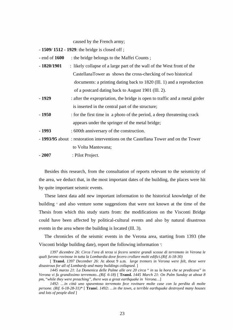
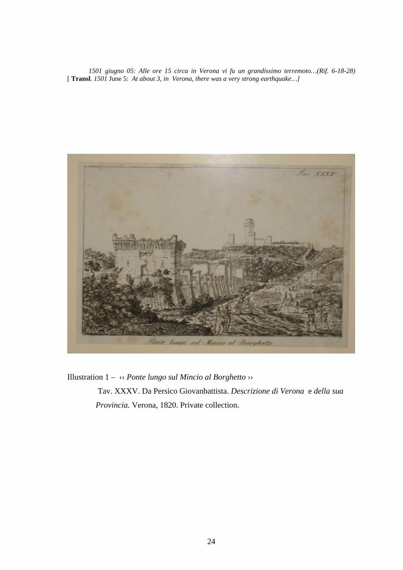
- 1820/1901 : likely collapse of a large part of the wall of the West front of the
CastellanaTower as shows the cross-checking of two historical
documents: a printing dating back to 1820 (Ill. 1) and a reproduction
of a postcard dating back to August 1901 (Ill. 2).
- 1929 : after the expropriation, the bridge is open to traffic and a metal girder
is inserted in the central part of the structure;
- 1950 : for the first time in a photo of the period, a deep threatening crack
appears under the springer of the metal bridge;
- 1993 : 600th anniversary of the construction.
- 1993/95 about : restoration interventions on the Castellana Tower and on the Tower
to Volta Mantovana;
- 2007 : Pilot Project.
Besides this research, from the consultation of reports relevant to the seismicity of
the area, we deduct that, in the most important dates of the building, the places were hit
by quite important seismic events.
These latest data add new important information to the historical knowledge of the
building 4 and also venture some suggestions that were not known at the time of the
Thesis from which this study starts from: the modifications on the Visconti Bridge
could have been affected by political-cultural events and also by natural disastrous
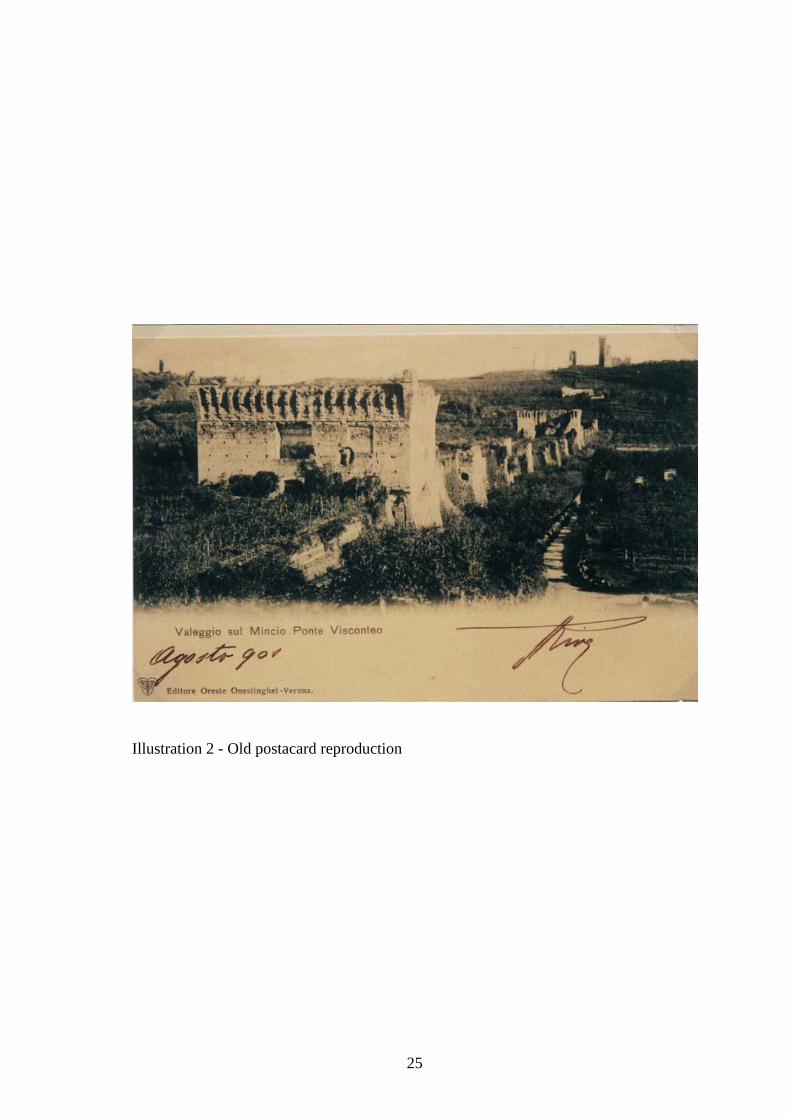
events in the area where the building is located (Ill. 3).
The chronicles of the seismic events in the Verona area, starting from 1393 (the
Visconti bridge building date), report the following information 5: 1397 dicembre 26: Circa l’ora di terza si fecero sentire grandi scosse di terremoto in Verona le
quali furono rovinose in tutta la Lombardia dove fecero crollare molti edifici.(Rif .6-18-30) [ Transl. 1397 December 26: At about 9 a.m. large tremors in Verona were felt, these were
disastrous for all of Lombardy and many buildings collapsed. ] 1445 marzo 21: La Domenica delle Palme alle ore 20 circa “ in su la hora che se predicava” in
Verona vi fu grandissimo terremoto...(Rif. 6-18) [ Transl. 1445 March 21: On Palm Sunday at about 8 pm, “while they were preaching”, there was a great earthquake in Verona…]
1492: …in città uno spaventoso terremoto fece rovinare molte case con la perdita di molte persone. (Rif. 6-18-28-31)* [ Transl. 1492: …in the town, a terrible earthquake destroyed many houses and lots of people died ]
24
1501 giugno 05: Alle ore 15 circa in Verona vi fu un grandissimo terremoto…(Rif. 6-18-28) [ Transl. 1501 June 5: At about 3, in Verona, there was a very strong earthquake…]
Illustration 1 – ‹‹ Ponte lungo sul Mincio al Borghetto ››
Tav. XXXV. Da Persico Giovanbattista. Descrizione di Verona e della sua
Provincia. Verona, 1820. Private collection.
25
Illustration 2 - Old postacard reproduction
26
Illustration 3 - The bridge’s constructive history and the places’ seismic events
1504 dicembre 31: …A Verona storicamente viene registrato come un grande terremoto. Le
repliche si protrarrono anche nell’anno 1505 per un periodo di quattro mesi. (Rif. 6-17-18) [ Transl. 1504 December 31: …A very strong earthquake is recorded in Verona. Tremors continued in 1505 for four month.] 1505 gennaio 3: …in Verona questa scossa benché sia stata de scritta grande non fece danni.. .(Rif. 6-18) [Transl. 1505 January 3: …in Verona this tremor, even if described as a big one, did not cause any damage …]
1511 marzo 26: … In Verona… la cronaca riporta …in fra le hore 20 e le 21 fu grandissimo terremoto tanto che nessuno mai ricordava di averne sentito di maggiori…( Rif. 6-17-18-28)* [ Transl. 1511 March 26: … In Verona… chronicles state that …between 8 and 9 pm, there was a very big earthquake that nobody remembered ever feeling one bigger…]
At this point of historiography, even if no archive documents report any news
relevant to the preservation conditions of the bridge, simple deductions on the ancient
27
wall conditions can be done by observing two historical images (shown above) of the
monument.
In the period between 1820/1901, the bridge seems to have suffered from other
damages which mainly affect the West front of the Castellana Tower.
From history, we know that these places were fields of great battles (1848 and 1866
Independence wars), but even the seismic chronology of those years seems to entwine
again with the destiny of the bridge.
Surely, the monument resisted to exceptional events, such as wars and earthquakes
that would cause, even singularly, great stresses to any building.
Leaving apart the historical events of that period, we report the most important
telluric movements that hit the Verona territory (hit also by other minor events) and
which could have contributed to damaging the bridge.
Shortly before this period, two earthquakes are reported in the area of Mount Baldo,
opening a long period of seismic activity that started in these areas: 1809 novembre 21: Si legge nè Ricordi Storici di G. Perazzini da Zevio, che negli anni 1809 e
1810 accadde uno dei massimi sismici nel Monte Baldo…(Rif. 7-22) [ Transl. 1809 November 21: the Ricordi Stoics by G. Perazzini da Zevio reports that, in 1809 and 1810, one of the greatest earthquakse took place at Monte Baldo…]
1810 maggio 01: Nel giorno una fortissima scossa del terremoto urtava le falde occidentali del Monte Baldo e venne avvertita sia sulla sponda Orientale che Occidentale del Lago…( Rif. 6-7-7bis-18-30) [ Transl. 1810 May 1: On that day, a very strong tremor hit the western stratums of Mount Baldo and was also felt on the Eastern and Western banks of the Lake …]
1866 febbraio 14: In quest’anno si aprì un nuovo e lungo periodo di agitazione sismica nel Monte Baldo, tremiti, scotimenti, muggiti sotterranei ed altri fenomeni minori…(Rif. 6-18-22) [ Transl. 1866 February 14: In this year, a new and long period of seismic agitation in Mount Baldo, tremors, shakes, underground noises and other minor phenomena ….]
1867: Continuò quest’anno nel Monte Baldo il periodo sismico. Sebbene l’intensità dei fenomeni fosse inferiore a quella dell’anno 1866 non mancarono dei massimi sismici intercalati con periodi di relativa calma ma mai assoluta. Uno di questi massimi sismici (sciami) accadde il 2 di febbraio quando i fenomeni sotterranei si produssero con straordinaria violenza.(Rif. 30) [ Transl. 1867: In this year, the seismic activity continued in the Mount Baldo. But the intensity of the phenomena was inferior to the one in 1866; large seismic swarms were alternated with relatively calm periods, although never completely. One of the greatest swarms took place on 2nd February when underground phenomena was particularly violent…]
1868 gennaio: Nel Monte Baldo dal mese di gennaio al luglio i fenomeni sismici non presentarono, si può dire, un periodo di tregua. Furono violentissimi specialmente nella prima e terza decade di gennaio e nella seconda di febbraio…(Rif. 18-19-30-32)****…[ Transl. 1868 January: From January to July, no seismic phenomena took place in Mount Baldo, we can say it was a period of truce. They were very violent in the first and last ten days of January and in the second ten days of February…]
1873: … Il giorno 15 giugno alle ore 9 pom. si avvertiva una scossa di terremoto a Riva del Garda….Nel giorno 29 giugno…..Fu fortissimo in tutta la catena del Monte Baldo e sulle rive del Lago di Garda quasi che il centro sismico Baldense svegliatosi a sua volta sovrapponesse le sue vibrazioni a quelle che si propagavano dal Bellunese…[ Transl. 1873: … on 15th June at 9 pm, a tremor was felt in Riva del Garda…On 29th June…..a very strong tremor along the entire chain of Mount Baldo and on the banks of Lake Garda as if the seismic centre of Mount Baldo also woke up and superimposed its vibrations to the tremor that propagated from the Belluno area …]
28
1879 gennaio 04: Nel corso dell’anno il Monte baldo si mantenne in uno stato di agitazione quasi mai interrotta…(Rif. 1-6-18-30-32) [ Transl. 1879 January 4: In the course of the year, Mount Baldo almost maintained a constant condition of agitation …]
1884 febbraio 19: “In questo mese fra il giorno 17 ed il 20 la trepidazione del suolo fu fortissima in Verona e nel Monte Baldo… (Rif. 4-18-30-22) [ Transl. 1884 February 19: “In this month, between 17th and 20th , the land tremor was very strong in Verona and Mount Baldo…]
1891: …Giornale l’Arena 8 giugno “IL TERREMOTO SENTITO IN CITTA” Da parecchi anni nel
Veneto non andavamo soggetti a violenti scosse di terremoto…una terribile scossa sussultoria preceduta da un rombo fortissimo mise soqquadro la popolazione. La scossa fu infatti tremenda…Giornale l’Arena 22 giugno…tutte le scosse telluriche erano precedute dall’urlo del rombo che veniva sempre dalle regioni del Monte Baldo…( Rif. 18-23-25-30-32)* [ Transl. 1891: …The L’Arena (newspaper) on 8th June, ”EARTHQUAKE IN THE CITY”. For several years in the Veneto Region, we haven’t suffered from the violent shakes of an earthquake. … a terrible shaking tremor proceeded by a very loud roar threw the population in confusion. In fact, the shaking was terrible. …The L'Arena on 22nd June … all telluric movements were proceeded by the roar that always came from the regions of Mount Baldo …]
1896: …il 18 settembre alle ore 01.17 ant. una scossa abbastanza forte preceduta da leggero rombo a carattere ondulatorio e della durata di 2 secondi si faceva sentire a Badia Calavena ed in tutta la Provincia con direzione Est- Ovest…(Rif. 30-32) [ Transl. 1896: …on 18th September at 1.17 am, a very strong tremor was proceeded by a light roar with an undulatory movement that lasted 2 seconds and was felt in Badia Calavena and in the entire Province from East-West…
1900 marzo 04: Un terremoto che colpiva fortemente il Trevigiano portando leggeri danni e molto panico nella popolazione irradiava le sue oscillazioni in tutto il Veneto compreso Verona e Provincia…(Rif. 32) [ Transl. 1900 March 4: A earthquake strongly hit the Treviso area and caused little damage, but much panic in the population and irradiated its shakes throughout the Veneto Region, including Verona and its Province …]
In the years when the Visconti Bridge was opened to traffic by the insertion of a
metal girder, another seismic wave hit the monument. 1931 aprile 15: …A Torri del Benaco fu forte con moto sussultorio – ondulatorio per la durata di
parecchi secondi…Secondo l’Osservatorio di Venezia l’epicentro fu nel Lago di Garda – Adamello…(Rif. 32)* [ Transl. 1931 April 15: …In Torri del Benaco, a strong shaking and undulatory movement lasting a few seconds ….According to the Venice Observatory, the epicentre was in Lake Garda – Adamello…]
1936 giugno 21: Uno sciame sismico interessò il Basso Garda con scosse più o meno sensibili, alcune delle quali furono intese fino a Verona…(Rif. 24-32)* [ Transl. 1936 June 21: A seismic swarm hit the Basso Garda area with, more or less, considerable tremors, a few of them were also felt in Verona…]
1948 luglio 19: …Un particolare allarme il terremoto lo ha suscitato nella zona del Garda dove nel 1930 i fenomeni sismici raggiunsero una eccezionale frequenza destando vivo panico fra quelle popolazioni…(Rif. 32) [ Transl. 1948 July 19: …A particular earthquake rose alarm in the Lake Garda area where, in 1930, the seismic phenomena was exceptionally frequent and caused great panic in the populations …]
1951: ...Il giorno 15 maggio un esteso terremoto con epicentro il confine Italo-Svizzero colpiva con notevole entità tutta l’Italia Settentrionale. Le scosse furono intese particolarmente intense nella zona del Lago di Garda...(Rif. 32) [ Transl. 1951: ...On 15th May, a large earthquake, with the epicentre in the Italian-Swiss border, greatly hit all of Northern Italy. The tremors were particularly felt in the Garda Lake area…]
A few months later, for a particular coincidence, on 10th February 1952 the
Engineer A. Carteri presented a COST ESTIMATE ‹‹ for the reinforcement and
arrangementof works in the Scaligero Castle and Visconti Bridge in Valeggio sul Mincio
›› 6, the total amount for the bridge restoration was 153,900 liras.
29
The intervention description is not specified : ‹‹ consolidation and reinforcement of the
walls, top parts and unsafe terracotta and stone walls with terracotta material, stones and
concrete mortar …››, but the amount itself indicates the substance of works.
The exceptional dimensions of the works weighed on the work estimate, but the
preservation conditions of the Bridge were surely already bothersome.
In the following years, other seismic tremors were reported, but luckily they were
quite moderate.
The last seismic event, sadly known at a national level, dates back to 1976, when
a violent earthquake hit the Friuli region and even irradiated the Verona area.
We also report the numerous and very violent tremors that, on 15th September,
struck the lands of the devastated Friuli again and were even felt in the entire
Veneto region.
In the Verona area, the telluric phenomenon was mostly perceived in the hilly
area and partially in the mountain area of the Lower Plain. 1976: …Il 13 dicembre alle ore 06.24.39 un terremoto pari al 6° Mercalli con la durata di
3/4 secondi provocava seri danni agli edifici del Centro storico di Riva del Garda…l’epicentro fu localizzato nella zona del Monte Baldo…(Rif. 32) *[ Transl. 1976: …On 13th December at 06.24.39 am, an earthquake, equal to 6 degrees on the Mercalli scale with a duration of 3-4 seconds, caused serious damage to the buildings of the Historical Centre of Riva del Garda…the epicentre was focused in the Mount Baldo area…]
Also in the 80’s and 90’s, other telluric movements are reported, but they are not
particularly significant.
During those years (1993/1995), there were the first important restoration works on
the Castellana Tower and on the Tower towards Volta Mantovana.
To finish this first phase of research, the only historical datum (deducted from an
Archives document) that we can deduct from studying the structure is the following :
the first repairing works that can be historically datable, also for the amount of the
expenses, involved a part of the walls and the covering of one of the towers.
Nothing is said about the preservation conditions of the basement part and, therefore,
we suppose that this is the true supporting system of the entire building up to the
beginning of the twentieth century.
In fact, the dimensions prove it : the foundations corresponding to the barrage have
a trapezoidal section at the base of 25 m and a top of 22 m.
30
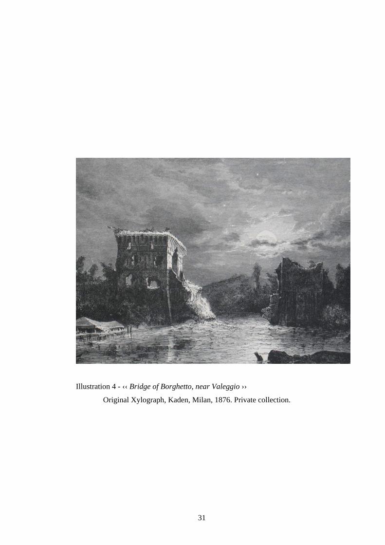
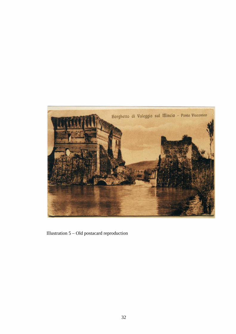
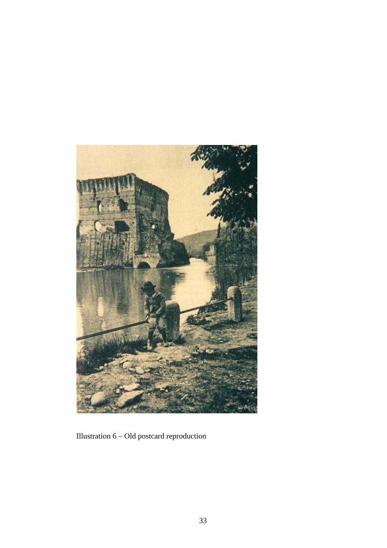
In three documents of the period, a xylograph of 1876 (Ill. 4) and two postcard
reproductions, dating back to the first years of the last century (Ill. 5-6), still show
the Visconti Bridge interrupted in the central part, but the deep crack that has been
marking the wall below the metal girder for several decades is not yet visible.
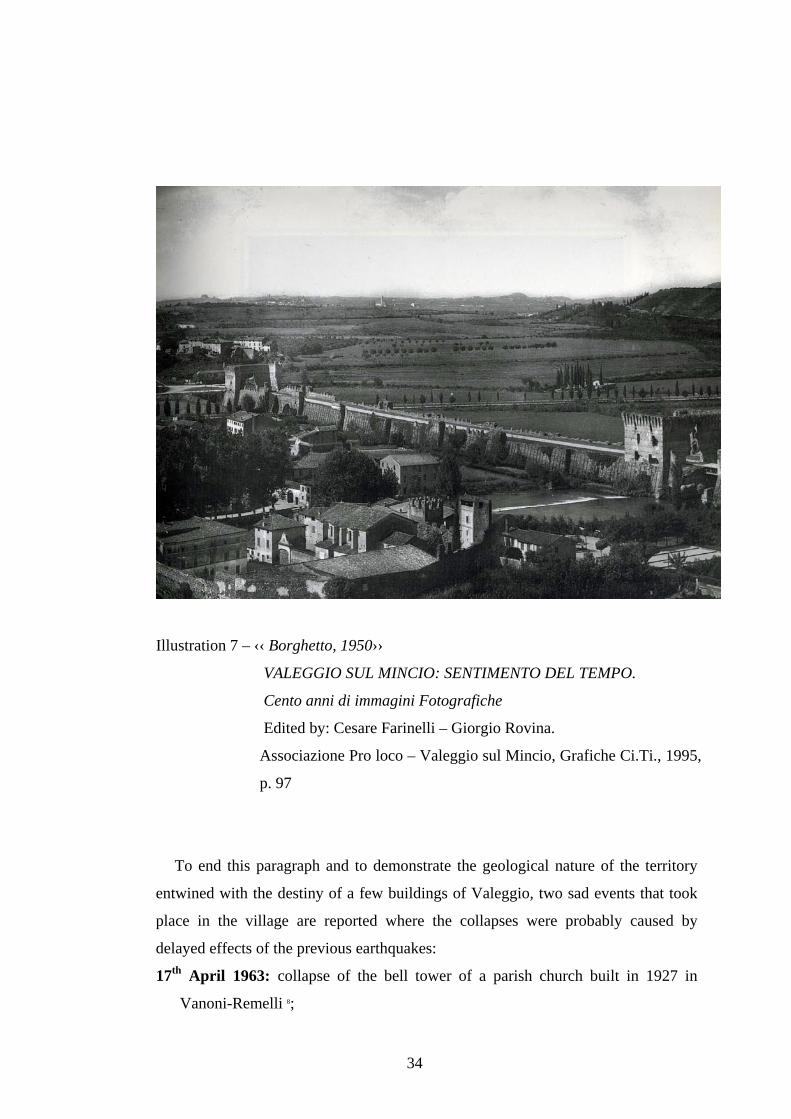
The first evidence of this subsidence is reported for the first time in a
reproduction of the time dating back to 1950 (Ill. 7) and its dimensions are alarming,
even at that time.
Nowadays, the situation is quite critical at this point of the structure.
The possible suggestion is that the modern insertion has probably affected (over
years) the supporting structure of the historical building that was probably also
weakened by seismic events.
Reading the ‹‹ VISIT REPORT AND TESTING CERTIFICATE of works relevant to
the construction of a passageway with a metal girder on the Mincio River for the
passage of the new town road on the Visconti Bridge of Borghetto ›› 7, we learn that,
after the load test, they reported a ‹‹…a permanent failure of the supports of 1 m/m and
a maximum permanent bending as regards the original position at the height of the centre-
line of m/m 4 for each girder ››, but these deformations were considered completely
normal.
31
Illustration 4 - ‹‹ Bridge of Borghetto, near Valeggio ››
Original Xylograph, Kaden, Milan, 1876. Private collection.
32
Illustration 5 – Old postacard reproduction
33
Illustration 6 – Old postcard reproduction
34
Illustration 7 – ‹‹ Borghetto, 1950››
VALEGGIO SUL MINCIO: SENTIMENTO DEL TEMPO.
Cento anni di immagini Fotografiche
Edited by: Cesare Farinelli – Giorgio Rovina.
Associazione Pro loco – Valeggio sul Mincio, Grafiche Ci.Ti., 1995,
p. 97
To end this paragraph and to demonstrate the geological nature of the territory
entwined with the destiny of a few buildings of Valeggio, two sad events that took
place in the village are reported where the collapses were probably caused by
delayed effects of the previous earthquakes:
17th April 1963: collapse of the bell tower of a parish church built in 1927 in
Vanoni-Remelli 8;
35
N 21st January 1977: collapse of the Serraglio Scaligero Tower that was used as a
bell tower in Valeggio.
In fact, the seismic chronology reports the following : 1963 marzo 4: Vivo allarme ma nessun danno per una scossa di terremoto di considerevole
intensità avvertita alle ore 23.31 in Verona e Provincia la scossa a carattere ondulatorio e con epicentro nei Monti Lessini è durata pochi secondi ed ha raggiunto l’intensità del 2° Mercalli…(Rif.32) [ Transl. 1963 March 4: Great alarm, but no damage, for a considerably intense tremor felt at 23.31 in Verona and Province; the undulatory shake lasted a few seconds and reached the 2nd degree of the Mercalli scale…]
- 1976 May 7: Verona was hit by a violent earthquake. Moreover, other strong
telluric movements took place on 15th September and 13th December of the same
year (as already reported in this study).
In the case of the Visconti Bridge, the symbol monument of Valeggio, the
historical events, the place seismic nature and human interventions (the use of the
historical structure as a road passage since the thirties of last century, which was
unsuitable to the building materials) have contributed to create a diffused
degradation condition with localized situations that reveal a structurally critical
Alberto and Tampone Gennaro, Manuale per la riabilitazione e la ricostruzione postsismica degli edifici.
Regione dell’Umbria, by Francesco Gurrieri, Rome, Dei Tipografia del Genio Civile, 1999. 2. A.S.VE. Senato terra, reg.2c - 205 (1451). 3. A.S.VE. Senato terra – filza 135 (3 Giugno 1594). 4. Le chiese e il terremoto, by F. Doglioni, V. Petrini, A. Moretti, Trieste, Edizioni LINT, 1994. 5. www.ips.it/scuola/concorso/terremoti/Indice.htm. Ricerca storico - scientifica sulla sismicità nel
veronese.. 6. COST ESTIMATE for the reinforcement and arrangementof works in the Scaligero Castle and
Visconti Bridge in Valeggio sul Mincio, Valeggio sul Mincio Protocol No. 900 Pres. 14th February
1952. 7. VISIT REPORT AND TESTING CERTIFICATE, Mantua, 25th May 1931 IX 8. Turrini Lino, Vanoni Remelli. Usi e costumi, Povegliano Veronese (Vr), Editrice
Gutenberg, 1990, p.22.
36
2.3 THE GEOMETRIC SURVEY OF THE BUILDING AND ITS PRESENT
DIMENSIONS
The following step for the building’s historical analysis and, in a certain sense, the
geometric description of the building is also the most critical moment of the entire
knowledge trail.
Besides being the interpretation base for the building evolution over the centuries (a
valid support to confirm news or suggestions deducted from the historical analysis and
archives), this survey is a very important moment because it is the first report relevant
to the physical conditions of the building and it is also the unique phase of the survey
that is carried out in place and in direct contact with the structure.
Starting from this phase, we will create the support to restoration activities as well as
to the following maintenance program to preserve the monument.
The metric reading allows a first macroscopic survey of the degradation and failure
in order to assess damage; these pathologies allow one to define the factors that affect
the structural efficiency, as their definitions will lead to a following phase relevant to
the assessment of vulnerability.
Then, in this study, the geometric survey is like the graphic reconstruction of the
parts that made the building and the consistency of the constructive elements; it will be
an essential analysis to define the first interpretation pattern of the structural functioning
of the building at a qualitative level. The following refinement of knowledge will allow
for the development of quantitative assessments corresponding to the different levels of
knowledge (LCi) and the assessment (LVi) foreseen by the above-mentioned legislative
regulations.
The first surveys of a historical building usually come from the iconographic
material.
Even if this source can be marred by obvious problems, such as :
- ‹‹ marcate imprecisioni nelle misure…›› [Transl. ‹‹ noticeable imprecisions of
it surely represents the starting point to understand the building nature and its
transformations over time.
The first ideal reconstruction of the Visconti Bridge dates back to the sixties by P.
Gazzola.
From the mid-eighties up to 1993, the six hundredth anniversary of the Bridge
construction, other reconstructions were made by academics or professionals who
entered into contact with the historical building for different reasons.
Other scientific surveys were added between 1995 and 1996 and they were developed
within a Thesis work as the following:
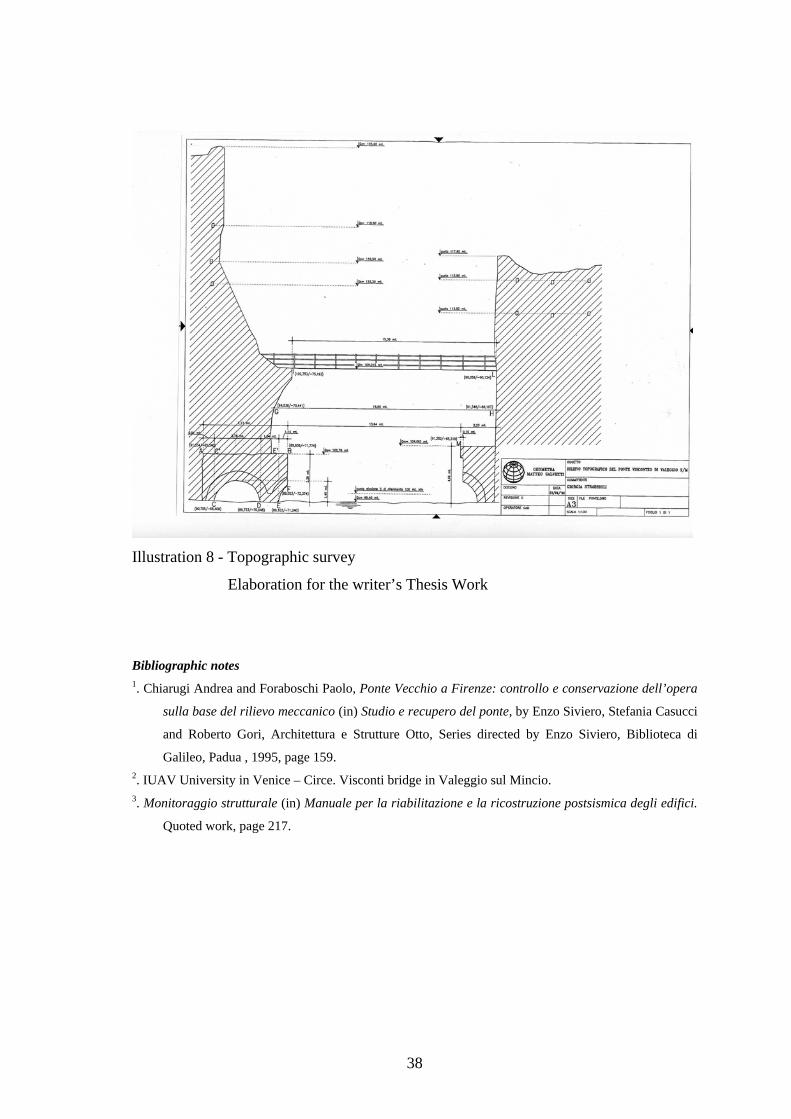
- topographic survey (of the central part of the Bridge) (Ill. 8);
- the underwater survey of the submerged part, this survey had never been done before.
These latest operations, together with the information from the Archives research,
record and show the place conditions as concerns the material consistency and
degradation and they even clarify a few points of the Bridge historiography that were
still unknown or uncertain, such as the backdating of the central part collapse, compared
with the tradition and the definitive evidence of the existence of remains of flooring
with a probable function of a platform at the bottom of the Mincio River at the height of
the dam body.
Finally the straightening of the entire building is also available 2.
With this survey and a complete and updated photographic documentation of the
elements, the operation was not easy because of the thick infesting vegetation that
covers the ancient walls; we can give a first evaluation of the damage progression in the
building in a precise interval of time by distinguishing the material naturally aged from
the material damaged by an external source (the ancient wall is in several points
reduced to minimum and worrying dimensions for its preservation) and finally we can
carry out the ‹‹ Structural monitoring ›› 3 to check for any worrying situations that affect
the stability. The final target is to create a pattern to be used for the seismic
vulnerability.
38
Illustration 8 - Topographic survey
Elaboration for the writer’s Thesis Work
Bibliographic notes 1. Chiarugi Andrea and Foraboschi Paolo, Ponte Vecchio a Firenze: controllo e conservazione dell’opera
sulla base del rilievo meccanico (in) Studio e recupero del ponte, by Enzo Siviero, Stefania Casucci
and Roberto Gori, Architettura e Strutture Otto, Series directed by Enzo Siviero, Biblioteca di
Galileo, Padua , 1995, page 159. 2. IUAV University in Venice – Circe. Visconti bridge in Valeggio sul Mincio. 3. Monitoraggio strutturale (in) Manuale per la riabilitazione e la ricostruzione postsismica degli edifici.
Quoted work, page 217.
39
2.4 THE PRESERVATION STATUS AND THE SURVEY OF THE MATERIAL DAMAGE
After reconstructing the bridge geometry and the structures support, the following
survey is the analysis of the construction materials.
The preservation status of the materials and construction elements are essential data
to define the safety level of the building.
This research phase is very difficult, since it needs surveys on the building itself and
these are often obstructed by its critical conditions.
An initial survey on the building’s current situation is the visual survey in the place.
A problematic picture arises immediately: a river context, a source of chemical attack
for the ancient walls in direct contact with it, and the road (the Provincial Road n° 55
and heavy traffic that crosses the entire structure daily) greatly fatigue the structure .
But the conditions of a ruin, in which the monument is now, also have its roots in
history.
The Ponte Longo (Long Bridge), as people from Valeggio called it, was probably
considered by its habitants as a quarry to collect material freely for their own
constructions.
In fact, according to past studies, the quantity of stones collected from the Bridge could
be compared to the quantity that a man standing up on a carriage with lifted arms could
take away.
Unfortunately, this act of vandalism is still practised on the monument and, if in the
past, it was caused by the poverty of a population, it is now an Italian bad habit, the
scandalous practice of the souvenir has continued for years at the Bridge, continuously
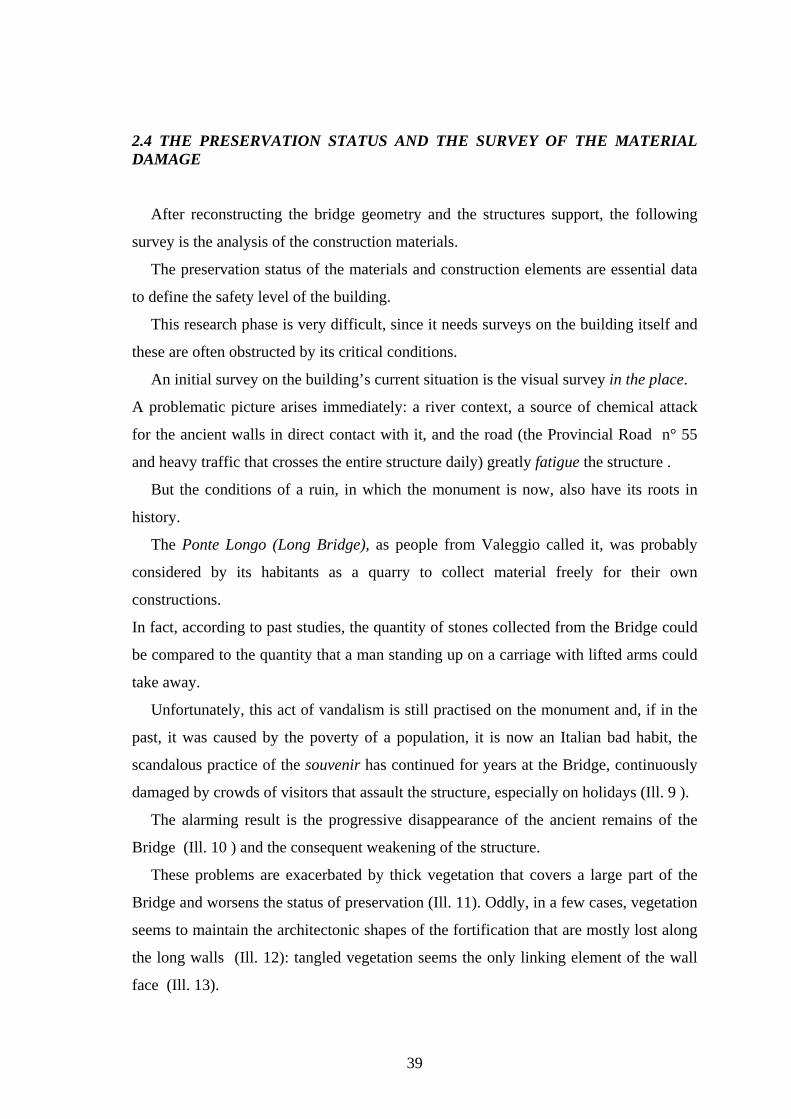
damaged by crowds of visitors that assault the structure, especially on holidays (Ill. 9 ).
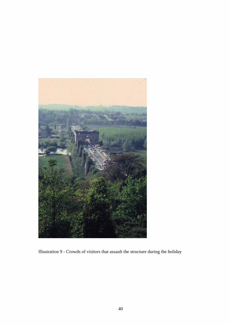
The alarming result is the progressive disappearance of the ancient remains of the
Bridge (Ill. 10 ) and the consequent weakening of the structure.
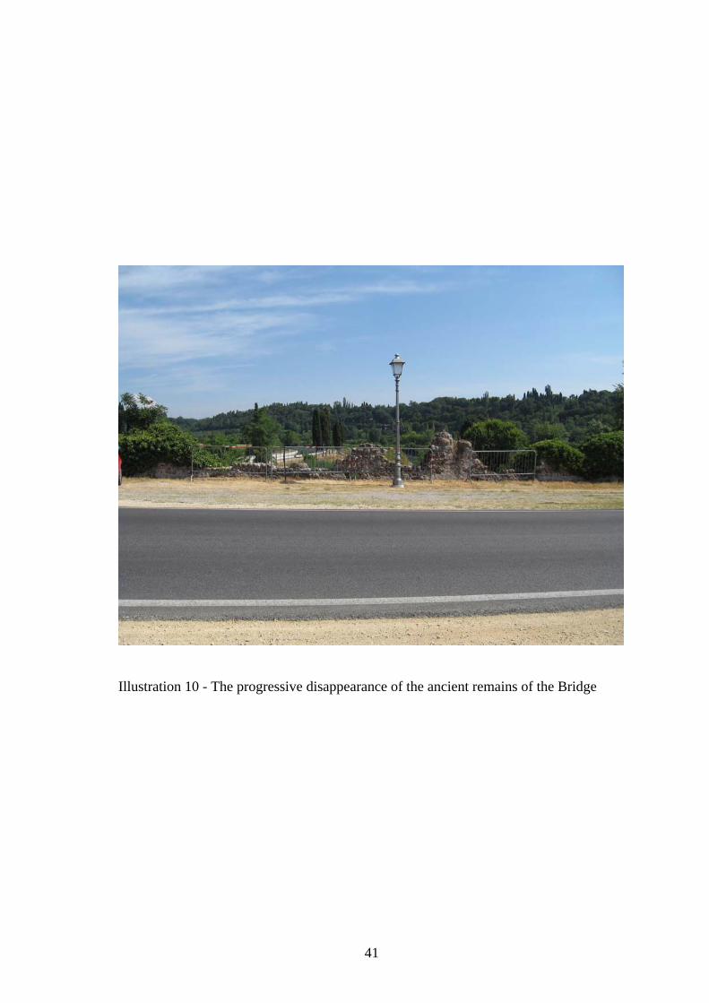
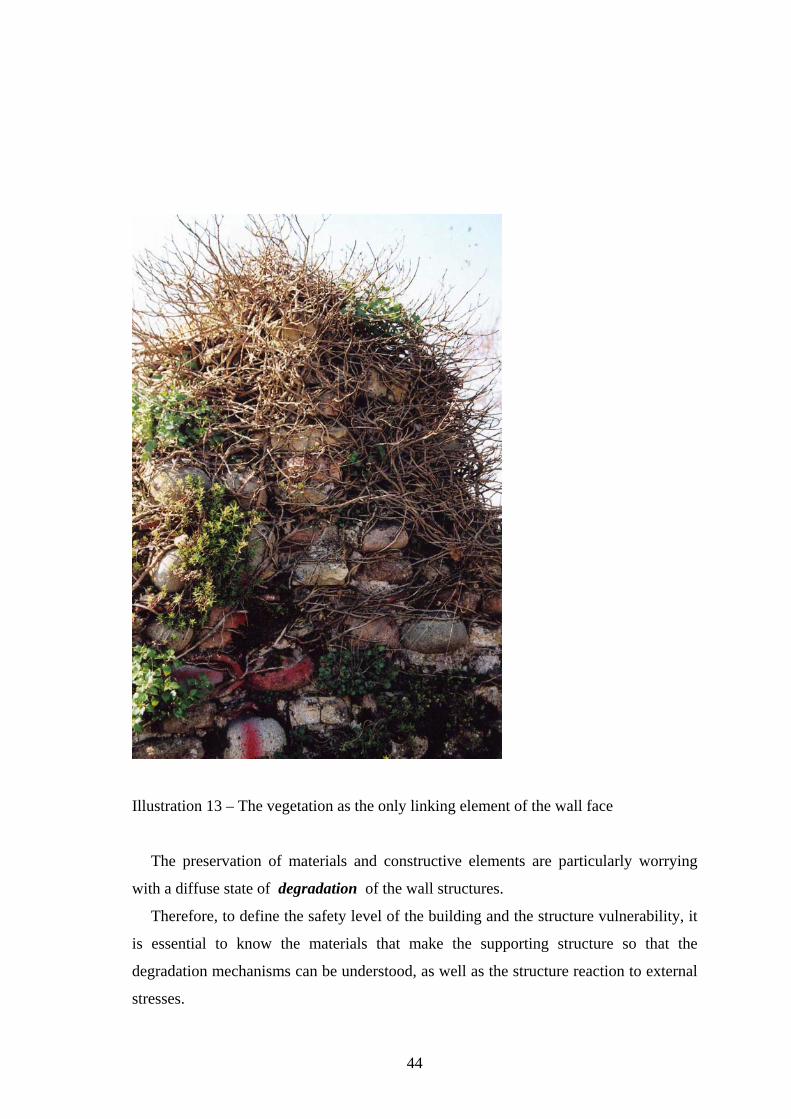
These problems are exacerbated by thick vegetation that covers a large part of the
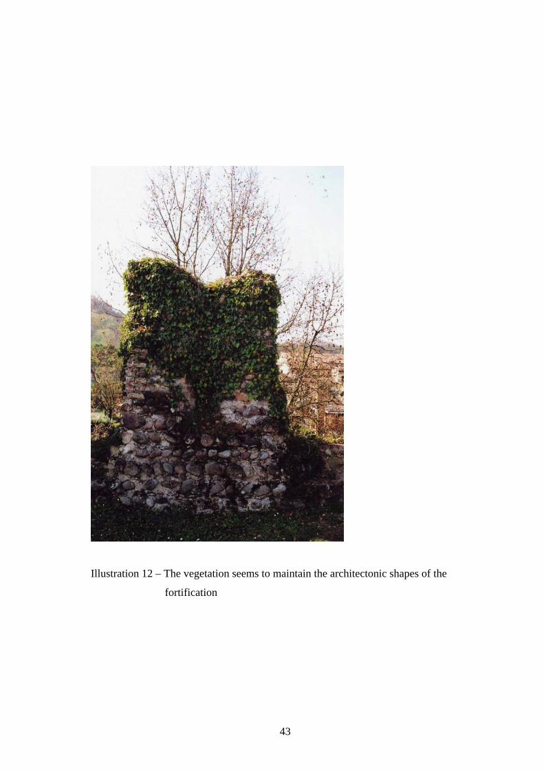
Bridge and worsens the status of preservation (Ill. 11). Oddly, in a few cases, vegetation
seems to maintain the architectonic shapes of the fortification that are mostly lost along
the long walls (Ill. 12): tangled vegetation seems the only linking element of the wall
face (Ill. 13).
40
Illustration 9 - Crowds of visitors that assault the structure during the holiday
41
Illustration 10 - The progressive disappearance of the ancient remains of the Bridge
42
Illustration 11 - Thick vegetation that covers a large part of the Bridge
43
Illustration 12 – The vegetation seems to maintain the architectonic shapes of the
fortification
44
Illustration 13 – The vegetation as the only linking element of the wall face
The preservation of materials and constructive elements are particularly worrying
with a diffuse state of degradation of the wall structures.
Therefore, to define the safety level of the building and the structure vulnerability, it
is essential to know the materials that make the supporting structure so that the
degradation mechanisms can be understood, as well as the structure reaction to external
stresses.
45
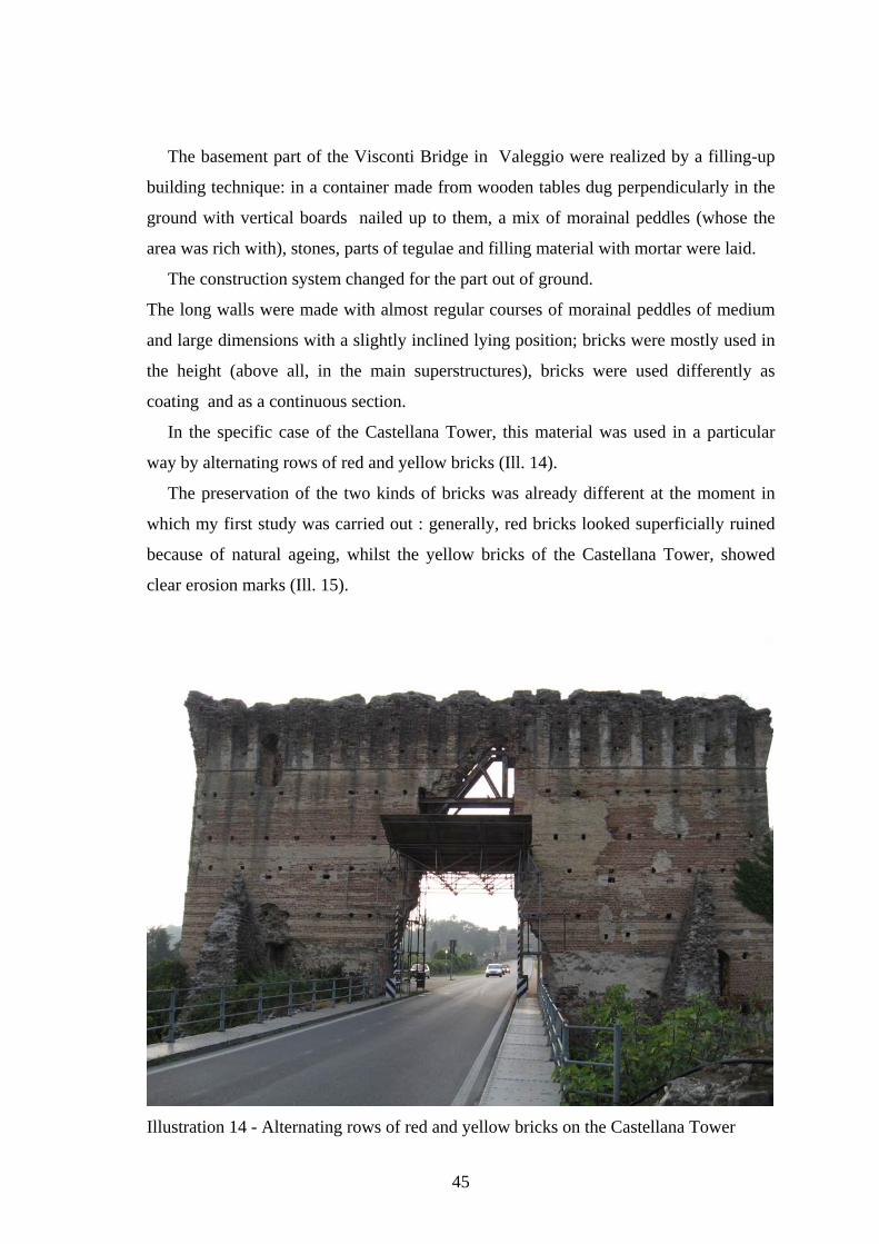
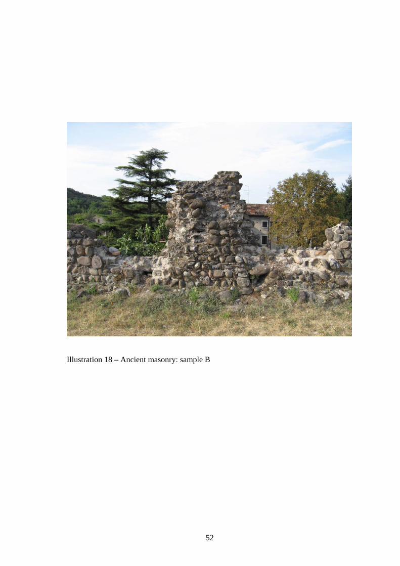
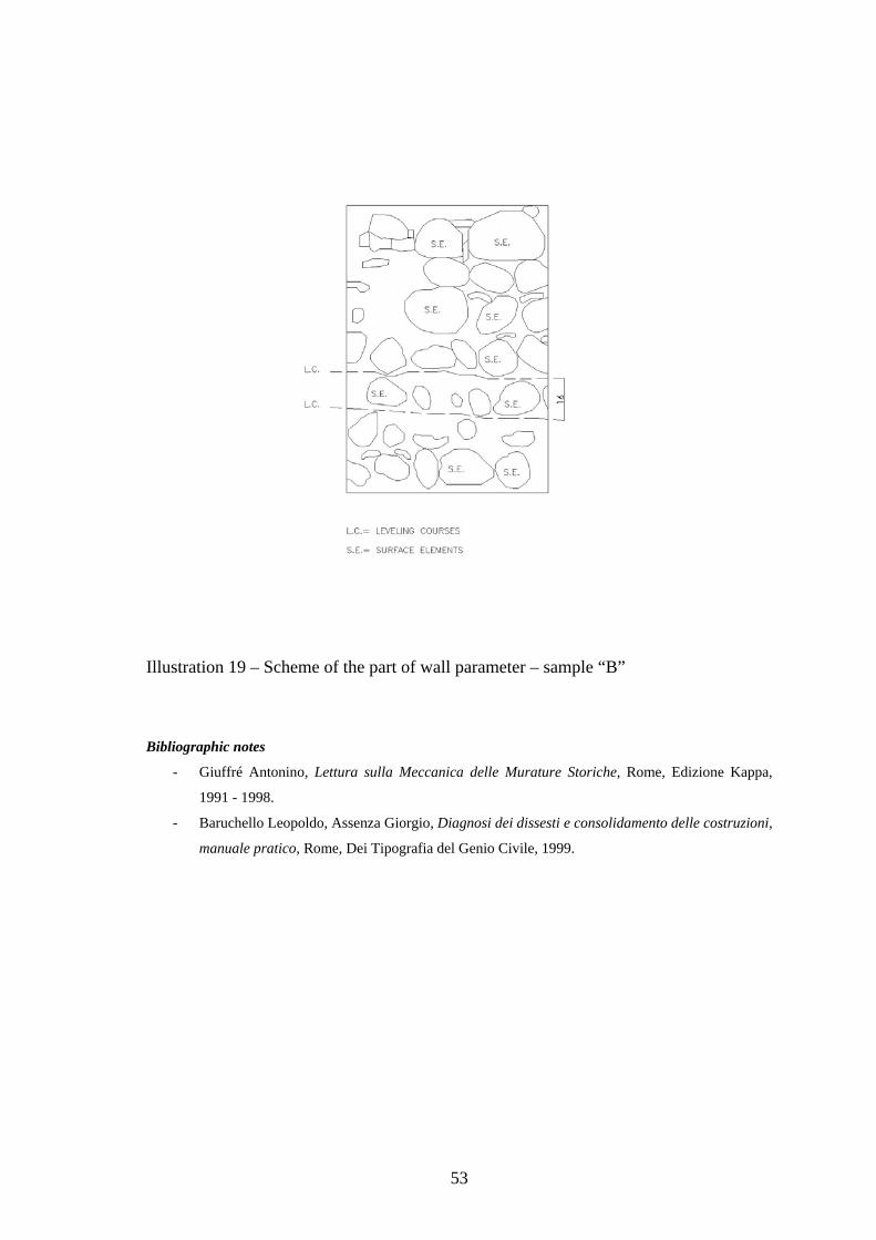
The basement part of the Visconti Bridge in Valeggio were realized by a filling-up
building technique: in a container made from wooden tables dug perpendicularly in the
ground with vertical boards nailed up to them, a mix of morainal peddles (whose the
area was rich with), stones, parts of tegulae and filling material with mortar were laid.
The construction system changed for the part out of ground.
The long walls were made with almost regular courses of morainal peddles of medium
and large dimensions with a slightly inclined lying position; bricks were mostly used in
the height (above all, in the main superstructures), bricks were used differently as
coating and as a continuous section.
In the specific case of the Castellana Tower, this material was used in a particular
way by alternating rows of red and yellow bricks (Ill. 14).
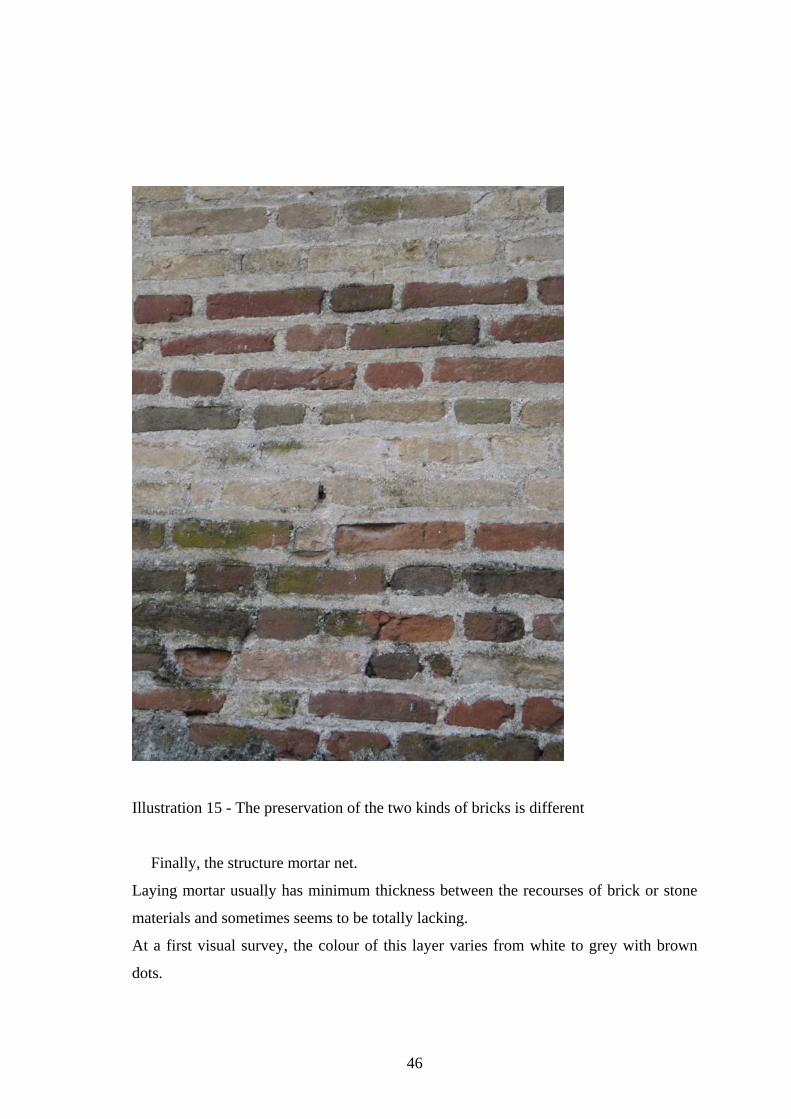
The preservation of the two kinds of bricks was already different at the moment in
which my first study was carried out : generally, red bricks looked superficially ruined
because of natural ageing, whilst the yellow bricks of the Castellana Tower, showed
clear erosion marks (Ill. 15).
Illustration 14 - Alternating rows of red and yellow bricks on the Castellana Tower
46
Illustration 15 - The preservation of the two kinds of bricks is different
Finally, the structure mortar net.
Laying mortar usually has minimum thickness between the recourses of brick or stone
materials and sometimes seems to be totally lacking.
At a first visual survey, the colour of this layer varies from white to grey with brown
dots.
47
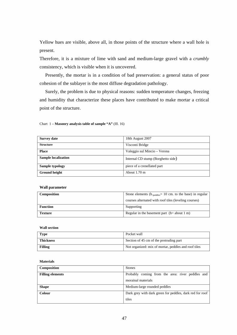
Yellow hues are visible, above all, in those points of the structure where a wall hole is
present.
Therefore, it is a mixture of lime with sand and medium-large gravel with a crumbly
consistency, which is visible when it is uncovered.
Presently, the mortar is in a condition of bad preservation: a general status of poor
cohesion of the sublayer is the most diffuse degradation pathology.
Surely, the problem is due to physical reasons: sudden temperature changes, freezing
and humidity that characterize these places have contributed to make mortar a critical