US COAST and GEODETIC SURVEY AERIAL CAMERA HISTORY Our records indicate that 1919 was the first year the Survey used photography taken from an aircraft to revise nautical and aeronautical charts. Early mapping programs were in cooperation with the Army and Navy Air Services. The photograph below shows a U.S. Navy biplane working on a USC&GS mapping project in the Mississippi River delta in 1921. These cooperative ventures furnished the survey aircraft, flight crews, and the aerial cameras necessary to enter into the newly developing science of photogrammetry. Using photogrammetry (measuring and drawing from photographs), charts were produced from aerial photographs, which was much easier than using ground based methods. Many different cameras and aircraft have contributed to the charting operations we know today. This camera collection may be viewed below. Early cameras used by the Survey had a single lens. Lens quality and aircraft performance limited early aerial survey photography to lower altitudes and a relatively narrow angle of view. For these reasons, multi-lens cameras were soon developed to increase the area covered by each frame of photography. Early multi-lens cameras exposed a separate film negative through each lens simultaneously. Later multi-lens designs exposed on one negative, with all multiple lens shutters opening concurrently. Thus the Survey had the Fairchild Camera Corporation build a 3-lens, a 4-lens, a 5-lens, and finally under the direction of Capt O.S. Reading a 9-lens aerial camera. As these multi-lens cameras were used, improved upon, and retired, single-lens cameras were experiencing improvements in lens resolution and increased angle-of-view. By the mid- 1940’s single-lens aerial cameras had an angle-of-view of around 90 degrees; quite an improvement from earlier single-lens varieties from the 1920’s whose AOV was only near 57 degrees. By the 1950’s, the Survey was using both the 9-lens and a variety of
Transcript
US COAST and GEODETIC SURVEY AERIAL CAMERA HISTORY Our records indicate that 1919 was the first year the Survey used photography taken from an aircraft to revise nautical and aeronautical charts. Early mapping programs were in cooperation with the Army and Navy Air Services. The photograph below shows a U.S. Navy biplane working on a USC&GS mapping project in the Mississippi River delta in 1921. These cooperative ventures furnished the survey aircraft, flight crews, and the aerial cameras necessary to enter into the newly developing science of photogrammetry. Using photogrammetry (measuring and drawing from photographs), charts were produced from aerial photographs, which was much easier than using ground based methods. Many different cameras and aircraft have contributed to the charting operations we know today. This camera collection may be viewed below. Early cameras used by the Survey had a single lens. Lens quality and aircraft performance limited early aerial survey photography to lower altitudes and a relatively narrow angle of view. For these reasons, multi-lens cameras were soon developed to increase the area covered by each frame of photography. Early multi-lens cameras exposed a separate film negative through each lens simultaneously. Later multi-lens designs exposed on one negative, with all multiple lens shutters opening concurrently. Thus the Survey had the Fairchild Camera Corporation build a 3-lens, a 4-lens, a 5-lens, and finally under the direction of Capt O.S. Reading a 9-lens aerial camera. As these multi-lens cameras were used, improved upon, and retired, single-lens cameras were experiencing improvements in lens resolution and increased angle-of-view. By the mid-1940’s single-lens aerial cameras had an angle-of-view of around 90 degrees; quite an improvement from earlier single-lens varieties from the 1920’s whose AOV was only near 57 degrees. By the 1950’s, the Survey was using both the 9-lens and a variety of
single-lens cameras, one with an 88mm focal length, giving an AOV of 140 degrees, making it an “ultra-wide” lens. Because of the larger negative size of multi-lens cameras, the Survey ended the honorable service of its last remaining multi-lens camera, the 9-lens, in 1961. The more recent cameras owned by the Survey are all single-lens. All are 6” (or about 152.5 mm) focal length, use film, and one, the Wild-Leica RC-30, has Forward Motion Compensation, and a film titling feature. This feature prints on the film margin the date, time of exposure, position of the center point of the photo frame as determined by GPS input, photo frame sequential number, plus exposure information. Forward motion compensation (FMC) works by moving the film vacuum plate (with the film firmly held in place by vacuum) during exposure in the apparent direction of the ground movement at the exact rate necessary to “freeze” the image. In addition to US Department of Commerce aircraft, NOAA Corps pilots and National Geodetic Survey flight crews, the Survey again began contracting for aerial photography in 1989. Today contractors collect aerial imagery over airports and over U.S. coastlines in order to map these areas. Some of these private companies use the Zeiss single-lens, 6” focal length, RMK TOP, or the Zeiss single-lens LMK. Others use the Leica RC-30 with newer generation lenses. Contracted experimental photography is being done at this time with the Zeiss DMC (Digital Mapping Camera), a large-format, multi-lens digital aerial camera; and with the Leica ADS-40, another large-format, but single-lens digital aerial camera. An even newer arrival to some contractors’ camera choices is the Vexel Ultra Cam, another multi-lens digital aerial camera. Present Survey operations use the Leica RC-30 and an Applanix DSS (Digital Sensor System) for rapid disaster response, and research and development. Future additions to the DSS system will be a geo-stabilized mount allowing for near-elimination of tip, tilt, and crab (yaw) in each image. In looking back on the occasion of the 200th Anniversary of the Survey, our pride in the technical development of the aerial camera as a survey instrument is clearly evident in our 1943-2008 collection of aerial photographs, and in the charts produced from them. Note: Aerial camera archival photographs in the following presentation are from the Fairchild Camera Corporation, Wild-Heerbrugg (all RC series), Leica Systems (RC-30, ADS-40), Zeiss Imaging (DMC), Vexel (Ultra Cam-X), and Applanix (DSS).
!
!
!
!
!
!
!
!
!!
!
!
!
DC
SEA
NIA BOS
CHISNF
LNB
NYC2NYC1
ST.L
CAPE
HOOK
N.O.
!
WAI
!
ANC
C&GS Aerial Photography
!
ST. CROIX
WASHINGTON, DC The Capitol
2000 2000
Full Frame of an area of An oblique view of the Capitol taken Washington DC directly from the frame to the left.
BOSTON HARBOR
USS Constitution 1999
These images are in stereo. Stereo, or Stereoscopic photography, consists of creating a 3-D illusion starting from a pair of 2-D images. This perception of depth occurs when providing the eyes of the viewer with two different images representing two perspectives of the same object. To see stereo you must try to see the pictures using your left eye to see the right picture and vice versus. Then you must slowly cross your eyes to see make the images in the center to come together. When the images converge you should see a 3D image.
CAPE CANAVERAL, FL
Launch Complex 1948 1983
These images are in stereo. Stereo, or Stereoscopic photography, consists of creating a 3-D illusion starting from a pair of 2-D images. This perception of depth occurs when providing the eyes
of the viewer with two different images representing two perspectives of the
same object. To see stereo you must try to see the pictures using your left eye to
see the right picture and vice versus. Then you must slowly cross your eyes to see make the images in the center to
come together. When the images converge you should see a 3D image.
CHICAGO, IL
Museum of Science and Industry U-505
1991 1991
Full Frame of an area of A view of the Museum taken Chicago, IL directly from the frame to the left.
The captured WW2 Nazi submarine U-505 lies berthed next to the Museum Main Hall. (Circled in red in right photo)
HONOLULU, HI Waikiki Beach
1960 1993
This was taken at 18,000 ft The photo above was taken at 17,500 (36,000 scale). It was taken for ft (35,000 scale). It was taken in Sept coastal mapping in October of 1960. 1993 for coastal mapping. Note changes in urban development; high-rise hotels, condominiums, malls. Street patterns remain unchanged but beach activity has increased significantly in 30 years.
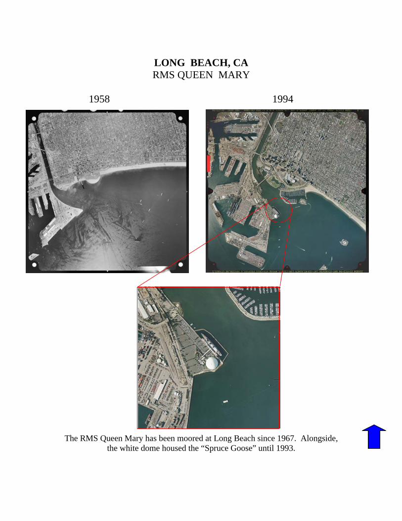
LONG BEACH, CA RMS QUEEN MARY
1958 1994
The RMS Queen Mary has been moored at Long Beach since 1967. Alongside, the white dome housed the “Spruce Goose” until 1993.
NIAGARA FALLS, NY
1972 1972
These were taken at 15,000 ft (30,000 scale). They were taken in September of 1972 for coastal mapping purposes. These images are in stereo. Stereo, or Stereoscopic photography, consists of creating a 3-D illusion starting from a pair of 2-D images. This perception of depth occurs when the eyes of the viewer are provided with two different images representing two perspectives of the same object. To see stereo you must try to see the pictures using your left eye to see the right picture and vice versus. Then you must slowly cross your eyes to see make the images in the center to come together.
When the images converge you should see a 3D image.
NEW YORK HARBOR Statue of Liberty
1974 1974
These were taken at 15,000 ft (30,000 scale).They were taken in September of 1972 for coastal mapping purposes. These images are in stereo. Stereo, or Stereoscopic photography, consists of creating a 3-D illusion starting from a pair of 2-D images. This perception of depth occurs when the eyes of the viewer are provided with two different images representing two perspectives of the same object. To see stereo you must try to see the pictures using your left eye to see the right picture and vice versus. Then you must slowly cross your eyes to see make the images in the center to come together. When the images converge you should see a 3D image.
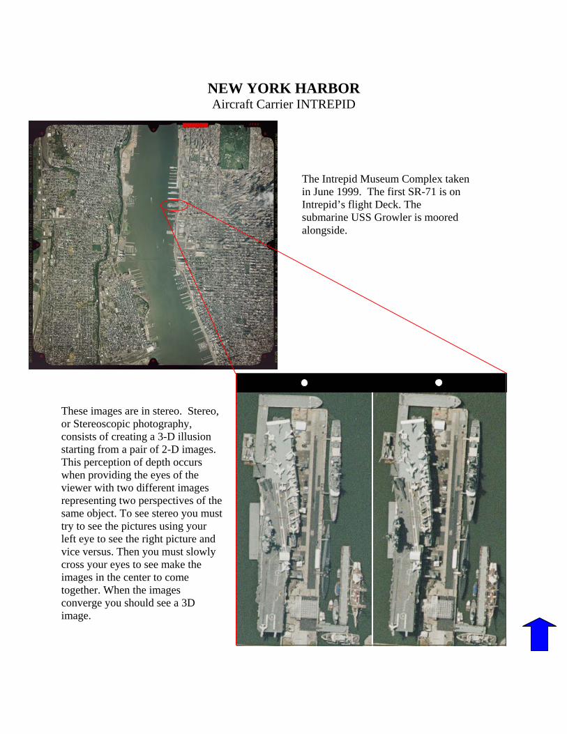
NEW YORK HARBOR Aircraft Carrier INTREPID
These images are in stereo. Stereo, or Stereoscopic photography, consists of creating a 3-D illusion starting from a pair of 2-D images. This perception of depth occurs when providing the eyes of the viewer with two different images representing two perspectives of the same object. To see stereo you must try to see the pictures using your left eye to see the right picture and vice versus. Then you must slowly cross your eyes to see make the images in the center to come together. When the images converge you should see a 3D image.
The Intrepid Museum Complex taken in June 1999. The first SR-71 is on Intrepid’s flight Deck. The submarine USS Growler is moored alongside.
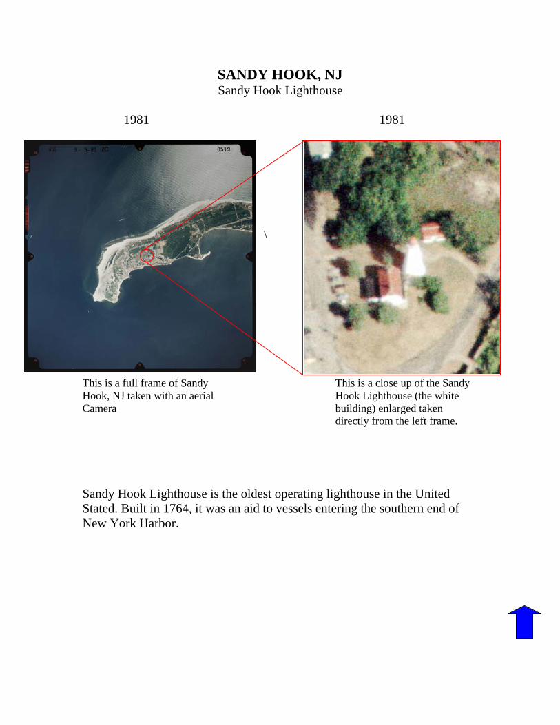
SANDY HOOK, NJ Sandy Hook Lighthouse
1981 1981
\
This is a full frame of Sandy This is a close up of the Sandy Hook, NJ taken with an aerial Hook Lighthouse (the white Camera building) enlarged taken directly from the left frame. Sandy Hook Lighthouse is the oldest operating lighthouse in the United Stated. Built in 1764, it was an aid to vessels entering the southern end of New York Harbor.
SAN FRANCISCO, CA Golden Gate Bridge
1966
This photo was taken at 12,000 feet (24,000 scale) in August of 1996 for the purpose of coastal mapping.
ST. LOUIS, MO. Gateway Arch
1972
At 630 ft the Gateway Arch is the tallest monument in the nation. It was completed in 1965 and dedicated in 1968. This photo was taken as part of a chart revision project of the confluence of the Mississippi and Missouri rivers at St. Louis.
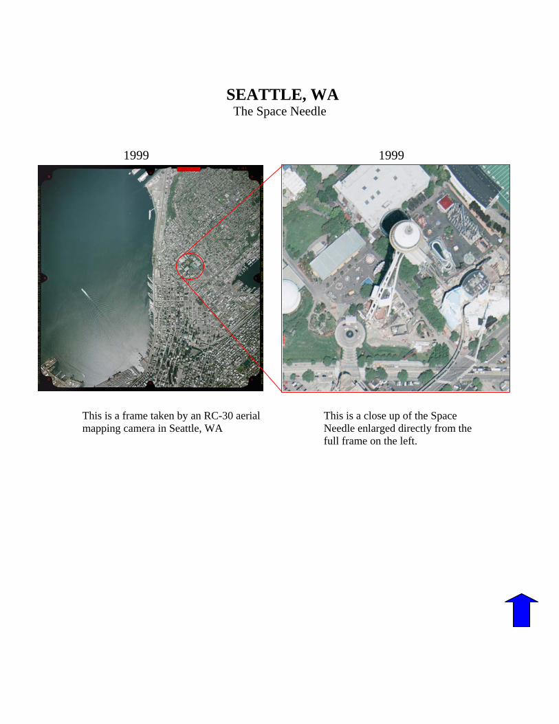
SEATTLE, WA
The Space Needle
1999 1999
This is a frame taken by an RC-30 aerial This is a close up of the Space mapping camera in Seattle, WA Needle enlarged directly from the full frame on the left.
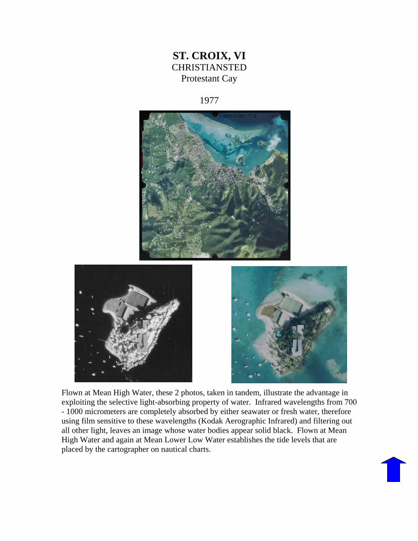
ST. CROIX, VI CHRISTIANSTED
Protestant Cay
1977
Flown at Mean High Water, these 2 photos, taken in tandem, illustrate the advantage in exploiting the selective light-absorbing property of water. Infrared wavelengths from 700 - 1000 micrometers are completely absorbed by either seawater or fresh water, therefore using film sensitive to these wavelengths (Kodak Aerographic Infrared) and filtering out all other light, leaves an image whose water bodies appear solid black. Flown at Mean High Water and again at Mean Lower Low Water establishes the tide levels that are placed by the cartographer on nautical charts.