U.S. NAVAL BASE, PEARL HARBOR, SEAi""LANE RAMPS - WORLD WAR II TYPE (Ramp Nos. 6, 7, 8, 9, and 10) (U.S. Naval Base, Pearl Harbor, Naval Air Station Ford Island, Facility Nos. S362, S364, S366, S367 & S368) Southwest and west shore of Ford Island, near Wasp Boulevard Pearl Harbor Honolulu County Hawaii PHOTOGRAPHS WRITTEN HISTORICAL AND DESCRIPTIVE DATA HISTORIC AMERICAN ENGINEERING RECORD PACIFIC GREAT BASIN SUPPORT OFFICE National Park Service U.S. Department of the Interior 1111 Jackson Street Oakland, CA 94607 HAER Hl-59 Hl-59
Transcript
U.S. NAVAL BASE, PEARL HARBOR, SEAi""LANE RAMPS -WORLD WAR II TYPE (Ramp Nos. 6, 7, 8, 9, and 10) (U.S. Naval Base, Pearl Harbor, Naval Air Station Ford Island, Facility Nos. S362, S364, S366, S367 & S368) Southwest and west shore of Ford Island, near Wasp Boulevard Pearl Harbor Honolulu County Hawaii
PHOTOGRAPHS
WRITTEN HISTORICAL AND DESCRIPTIVE DATA
HISTORIC AMERICAN ENGINEERING RECORD PACIFIC GREAT BASIN SUPPORT OFFICE
National Park Service U.S. Department of the Interior
1111 Jackson Street Oakland, CA 94607
HAER Hl-59 Hl-59
HISTORIC AMERICAN ENGINEERING RECORD
U.S. NAVAL BASE, PEARL HARBOR, SEAPLANE RAMPS -WORLD WAR II TYPE (U.S. Naval Base, Pearl Harbor, Naval Station Ford Island)
Location:
(U.S. Naval Base, Pearl Harbor, Ramps 6, 7, 8, 9, and 10) (Facility Nos. S362, S364, S366, S367, and S368)
HAER No. Hl-59
Southwest and west shore of Ford Island, near Wasp Boulevard Ford Island Pearl Harbor Naval Base City and County of Honolulu, Hawaii
U.S.G.S. Pearl Harbor Quadrangle, Hawaii, 1999 7.5 Minute Series (Topographic) (Scale-1 :24,000) Universal Transverse Mercator Coordinates:
Facility No. S362 04.607110.2362120
Facility No. S364 04.606920.2362290
Facility No. S366 04.606900.2362430
Facility No. S367 04.606930.2362560
Facility No. S368 04.607010.2362680
Date of Construction: 1941-1943
Designer:
Builder:
Present Owner:
Present Use:
Significance:
Prepared by:
Fourteenth Naval District Public Works Office based on standard plans of U.S. Navy, Bureau of Yards & Docks
Contractors, Pacific Naval Air Bases
U.S. Navy
Not in use
Facility Nos. S362, S364, S366, S367, and S368 are associated with the expansion of Naval Air Station facilities on Ford Island during World War II. They reflect the Navy's continuing use of seaplanes during this war. The concrete parking area adjacent to the ramps show evidence of the December 7, 1941 attack, which targeted the planes there; strafing marks remain in the concrete. These facilities are contributing properties to the Pearl Harbor National Historic Landmark.
Mason Architects, Inc. 119 Merchant St., Suite 501 Honolulu, HI 96813
AMEC Earth & Environmental, Inc. 3375 Koapaka Street, Suite F251 Honolulu, HI 96819
Date of Final Report: November 2005
U.S. NAVAL BASE, PEARL HARBOR, SEAPLANE RAMPS -WORLD WAR II TYPE (U.S. Naval Base, Pearl Harbor, Naval Station Ford Island)
(U.S. Naval Base, Pearl Harbor, Ramps 6, 7, 8, 9, and 10) (Facility Nos. S362, S364, S366, S367, and S368)
HAER No. Hl-59 (Page 2)
Description: The five World War II (WWII) seaplane runways are relatively narrow reinforced-concrete ramps which slope into the waters of Pearl Harbor from the southwestern end of Ford Island. Facility No. S362 is the easternmost of the five ramps, and is located near the south corner of the island's central landing mat for land planes. The other four WWII ramps (Facility Nos. S364, S366, S367, and S368) are on the opposite side of that central landing mat, jutting down into the harbor waters in a southwest or western direction. These four ramps are all connected to a large concrete apron or "seaplane parking area" (Fourteenth Naval District 1943). Kiawe trees and other vegetation have grown in the unpaved shoreline areas adjacent to these ramps, during the decades of non-use.
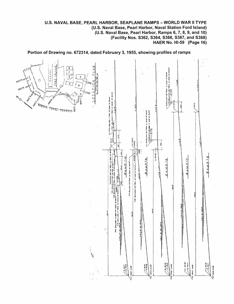
All of these WWI I ramps are 50'-0" wide, much narrower than the earlier Navy seaplane runways on Ford Island. They all have 1 O" wide, 1 O" high concrete curbs at their sides as well as at their bottom (submerged) ends. Mooring cleats are installed on the curbs near the tops of the ramps, made of zinc-coated cast steel according to a 1940 drawing (no. 141489). Various lengths are given for the WWII ramps, depending on the source. Unless otherwise noted, the lengths and grades below are from a 1955 drawing (no. 672314) that shows the profiles of all the island's seaplane ramps. The Navy property inventory lists all of the WWII seaplane ramps as 160' in length, except for Facility No. S362, which is listed as 200' long (U.S. Navy 1995: 70 & 73).
Facility No. S362 is 195'-0" long, with about 130' of it below mean low water (MLW). It has a 7.5% grade. Its top edge abuts a flatter concrete slab which widens from that edge and blends into the seaplane hangar aprons and the aircraft warming-up platform on the southeast side of the central runway. This WWII ramp was built on the edge of the older seaplane ramp area. It is connected to the other 1940s seaplane ramps and parking area on the opposite side of the central runway by Wasp Boulevard (the circle-island road which becomes Lexington Boulevard), which crosses the concrete slab at the top of this ramp.
Facility No. S364 has the same length as Facility No. S362, according to the 1955 drawing. It has a 7.4% grade. These two are the longest, and have the lowest slope, of all the seaplane ramps on Ford Island. They are the closest to the Ramp "B" type, one of two standardized designs shown on a 1940 seaplane ramp drawing (no. 141489).
Facility Nos. S366, S367, and S368 are all 150'-0" long, with about 100' of each below MLW. According to the 1955 drawing, they have similar grades, either 9.7% (Facility Nos. S366 and S367) or 9.8% (Facility No. S368). However, a 1940 (pre-construction) drawing shows that the grade planned for Facility No. S367 was 7.5% (no. 141488). The length of these three ramps does not match the Ramp "A" or "B" types in the 1940
U.S. NAVAL BASE, PEARL HARBOR, SEAPLANE RAMPS - WORLD WAR II TYPE (U.S. Naval Base, Pearl Harbor, Naval Station Ford Island}
(U.S. Naval Base, Pearl Harbor, Ramps 6, 7, 8, 9, and 10) (Facility Nos. S362, S364, S366, S367, and S368}
HAER No. Hl-59 (Page 3)
"plan, section and detail" drawing (no. 141489) of the ramps, although that drawing has an added label "Ramps 9 & 1 O" (Facility Nos. S367 and S368).
A 1940 drawing (no. 141489) of the ramps shows the typical construction was a reinforced concrete slab 9" thick that is cast-in-place with integral reinforced concrete beams, which are approximately 1' thick and 1 '-9" in depth (in addition to thickness of slab). These beams are spaced in a 15'-0" square pattern. The sides of the ramps overhang the underlying beams by 2'-6", and the ends are 5'-0" beyond the beams. The ramps rest on 18"-square reinforced-concrete piles, detailed on another 1940 drawing (no. 141490).
The top edges of four ramps (Facility Nos. S364, S366, S367, and S368) connect to the large seaplane parking area, which has a 1.2% to 2.2% grade. Facility No. S364 is about 135' from that area's south end. This end of the seaplane parking area has an axis oriented north/south and is approximately 300' wide. About 500' from its south end, the parking apron's axis makes a dog-leg turn to the northeast (at about a 30° angle), widening to about 380' and extending over 1100' more. Facility No. S368 was originally about 400' from the north end of the parking area. Much of the northern part of this seaplane parking area has been covered by the new brig (Facility No. 462) built in 1991. The circle-island road, following the same dog-leg bend of the parking area, runs about 40' from the parking area's east edge.
The 5"-thick concrete paving of the parking area is divided into 20'-0" x 30'-0" sections by expansion joints, construction joints, and dummy joints. A 1940 drawing (no. 141491) indicates that the construction joints were to be spaced 120' on center and the construction joints 20' on center along the length of the parking area, with the dummy joints at 30' on center across the width. That same drawing shows that securing rings for aircraft were to be spaced at 20' on center both ways. The detail drawing of these securing rings (no. 141490) shows they are in oval-shaped recesses in the pavement, and are made from %"-diameter bronze rods, shaped and embedded in the concrete. The shoreline at all five of the WWII seaplane ramps was extended out from the original line by fill. Steel sheet piling was installed to create bulkheads, and compacted fill was place on both sides, for the ramps and for the seaplane parking area, as detailed on a 1940 drawing (no. 141490). The bulkheads were 25'-0" high and buried into the earth to leave 10' of their height above MLW. Every 10'-8" the bulkheads were connected, via a 1%"-diameter tie rod, to a 4'-0" wide and 11'-0" high deadman of steel sheet piling, located 40'-0" inland of the bulkhead.
The parking area and adjacent paving still has strafing marks from the December 7, 1941 Japanese attack, created by machine gun fire from their airplanes. There are five lines or clusters of these marks, as shown
U.S. NAVAL BASE, PEARL HARBOR, SEAPLANE RAMPS - WORLD WAR II TYPE (U.S. Naval Base, Pearl Harbor, Naval Station Ford Island)
(U.S. Naval Base, Pearl Harbor, Ramps 6, 7, 8, 9, and 10) (Facility Nos. S362, S364, S366, S367, and S368)
HAER No. Hl-59 (Page 4)
on a figure included with this report. One set of marks is a line about 185' long and oriented north/south near the south end of the parking area, between its east edge and Wasp Boulevard. There is a small cluster of marks, about 80' southwest of that long line. Strafing marks are also located in the parking area pavement near the top of the Facility No. S366 ramp. One set of marks is about 50' southeast of that ramp and another set about 150' east-southeast. The fifth group of strafing marks is a line about 270' long, located at the northeast corner of the parking area, oriented southwest to northeast.
As the aerial photo mapped with the strafing marks shows, there have been several trenches cut along the edge and across the seaplane parking area. These have been repaved with asphalt. Two of the asphalt strips lead to the foundations of the former Squadron Offices (Facility Nos. 178 and 179). There is a tree growing at the seaward end of another repaved trench between Facility Nos. S366 and S367. There is also some dense vegetation growing near the dog-leg turn of the parking area. This vegetation became established after a building here was removed. Portions of the seaplane parking area and the flatter pavement above Facility No. S362 are now used as open storage for equipment and materials.
Historical Context: Refer to HABS No. Hl-382 for an overview of the history of Ford Island. For information on the earlier Navy seaplane runways, see HAER Nos. Hl-57 and Hl-58.
Prior to 1940, Ford Island was used jointly by Navy and Army aviation branches. The two services shared the central airstrip and the Army constructed several buildings, as well as two seaplane runways, on the west side of the island. The first Army air squadron was established on Ford Island in late 1918, after two seaplane hangars and ramps, a warehouse, and a shop building had been erected (Yates 1936: 54). Although a 1922 Navy map (U.S. Naval Station, Pearl Harbor 1922) shows a third seaplane ramp on the Army side of the island, this additional ramp is not seen in aerial photos and apparently was never built. Army aviation soon switched its emphasis to land planes. The continuing expansion of both Navy and Army aviation led to the realization that Ford Island was too small to accommodate both services. Although the Hickam Field site was selected for a new Army airfield in 1928, land purchase was not completed until 1935; and the majority of the Army aviation units did not move from Ford Island until October 1939 (Anderson and Bouthillier 1996: 36, 39).
There was a tremendous expansion in naval aviation between 1938, when the Navy was authorized at an air strength of 1,000 aircraft, and mid-1940, after outbreak of the war in Europe, when "the growth of the Navy's air arm to 15,000 aircraft" was approved (Pedrotty et. al 2001:
U.S. NAVAL BASE, PEARL HARBOR, SEAPLANE RAMPS - WORLD WAR II TYPE (U.S. Naval Base, Pearl Harbor, Naval Station Ford Island)
(U.S. Naval Base, Pearl Harbor, Ramps 6, 7, 8, 9, and 10) (Facility Nos. S362, S364, S366, S367, and S368)
HAER No. Hl-59 (Page 5)
4-21 ). The Navy needed all of Ford Island to accommodate part of this increase and plans for facilities such as these seaplane ramps were rapidly developed.
The last section of Army aviation that moved from Ford Island was the Hawaiian Air Depot (HAD). A June 1940 map delineates this HAD area in the southwest corner and notes that it "was to be relinquished to the Navy by Nov. 1, 1940" (Fourteenth Naval District 1940). Most of the Navy's WWII seaplane parking area and three of its five WWII seaplane ramps (Facility Nos. S364, S366, and S367) were built in this former HAD location. Facility Nos. S362 and S368 were built on land that the Navy had acquired earlier.
An inset map on the location plan (drawing no. 141488) for the WWII seaplane ramps, dated June 1940, shows that all five were originally to be located in the southwestern corner of Ford Island. However, that corner was not filled to become the shape shown in that drawing. In that inset location plan four of the ramps were shown aligned at the same angle along a straight shoreline, and slightly closer together than they were actually built. The ramps were constructed with the varying angles and the parking area with a dog-leg turn, as discussed in the description section. Both because of the change in final shoreline configuration and the decision to have wider spacing between ramps, there was not room for five seaplane ramps in that corner of the island. An April 9, 1941 drawing (no. 2721) shows that ramp #1, instead of being on the southern end of the group of five, was relocated to the eastern side of the central landing strip. This ramp became Facility No. S362. The history of the numbering of these facilities is discussed later.
The title blocks for the June 1940 drawings (nos. 141488 to 141491 and 142053) for the seaplane ramps are too faint to read, but they are signed by H.F. Bruns, the District Public Works Officer at Pearl Harbor during that period. Thus, the Fourteenth Naval District Public Works Office evidently prepared them, based on standardized plans from the U.S. Navy, Bureau of Yards & Docks. Because the constructed ramps (see description section) do not reflect the length dimension or grade of the Proposed Ramp Type A on those drawings, it is likely that the Contractors Pacific Naval Air Bases (CPNAB) made some alterations during construction. The 1941 relocation drawing (no. 2721) for Ramp #1 (later Ramp 6 or Facility No. S362) was prepared by CPNAB, but they even made changes from their own drawings; drawing no. 2721 does not reflect the final shape of that ramp. Speed of construction during this build-up to the war was the main consideration, not documentation of changes.
Apparently construction on all the WWI I ramps started in 1941. Overlaying a 1942 or later map on a 1940 or earlier one shows that fill was used to create a shoreline further west of the Army seaplane ramps.
U.S. NAVAL BASE, PEARL HARBOR, SEAPLANE RAMPS - WORLD WAR II TYPE (U.S. Naval Base, Pearl Harbor, Naval Station Ford Island)
(U.S. Naval Base, Pearl Harbor, Ramps 6, 7, 8, 9, and 10) (Facility Nos. S362, S364, S366, S367, and S368)
HAER No. Hl-59 (Page 6)
These Army ramps were located under the parking area between Facility Nos. S366 and S367. A historic photo shows that construction had covered over the Army ramps and demolition of the nearby Army buildings had started by January 30, 1941 (Naval Air Station, Pearl Harbor [19451). A photo dated March 1941 shows two seaplane ramps (Facility Nos. S367 and S368) under construction, and another photo dated November 1941 shows the completed seaplane parking area (National Archives II).
The work in this corner of Ford Island was just part of the massive construction effort underway at Pearl Harbor and other military installations in the Pacific. Most of the building was being done for the Navy by a consortium of firms called Contractors Pacific Naval Air Bases (CPNAB), although their work was not limited to aviation facilities. The subject caption on an October 10, 1941 photo implies that seaplane ramps on both sides of Ford Island were completed by that date (National Archives II). An administrative history also notes that the ramps and parking areas were 90% complete by December 1941 (Historical Section, Fourteenth Naval District [1945]: 518, footnote 3). However, the builders' report notes the final completion date of the seaplane ramps as December 1942 (Contractors Pacific Naval Air Bases n.d.: A-562). One ramp was apparently holding up final completion of that segment of CPNAB's work, since the report notes difficulty in the construction of one of them. The typical sequence of seaplane runway construction in this period, "used at Naval air bases everywhere, was to drive steel sheet piling in a watertight wall completely around the area where the ramps were to be placed, pump it dry, drive the foundation piles, build wooden forms around their upper ends, and then pour the concrete beams and slabs as a single structure" (Woodbury 1946: 120-121 ). The CPNAB report confirms that this system was used for all but one of the WWII seaplane ramps on Ford Island.
In erection of the five seaplane ramps, steel sheet piling was driven outboard from the shore; then the cofferdam was unwatered and excavated. Concrete forms were then built for the beam and girder structure of the seaplane ramp. One of the seaplane ramps could not be built as described, because of excessive leakage into the cofferdam; the underlying coral was too hard to allow sufficiently deep penetration of the sheet piling. This ramp was built of precast members without unwatering the site (Contractors Pacific Naval Air Bases n.d.: A-589).
The precast method of construction was probably similar to the one used for the 1922 seaplane ramp, Facility No. S360 (see HAER No. Hl-58). The CPNAB report does not specify which WWII seaplane ramp was built of precast members after the cofferdam method failed, but it was probably Facility No. S362. This one has a 1943 date in the Navy database, while
U.S. NAVAL BASE, PEARL HARBOR, SEAPLANE RAMPS - WORLD WAR II TYPE (U.S. Naval Base, Pearl Harbor, Naval Station Ford Island)
(U.S. Naval Base, Pearl Harbor, Ramps 6, 7, 8, 9, and 10) (Facility Nos. S362, S364, S366, S367, and S368)
HAER No. Hl-59 (Page 7)
the other ramps are listed with 1941 dates (U.S. Navy 1995). Although all those dates are different from the 1942 date given by CPNAB, the later date for Facility No. S362 does imply difficulty in construction. Also a photo taken on December 8, 1941 shows that grading work had barely started on this ramp, whereas the March 1941 photo showed the cofferdams in place for two of the other ramps (National Archives II). There is further uncertainty about the completion date of Facility No. S362. An aerial photo taken in May 1942 shows an airplane parked near it and confirms that construction of at least the above-water portion of this ramp was completed by then (U.S. Army Museum of Hawaii 1942).
There are three June 1940 drawings (nos. 141489 to 141491) which are labeled "Ramps 9 & 1 O" (Facility Nos. S367 and S368) in a box below the title block. However, in the drawing one runway (Facility No. S367) is shown as Ramp "A" and the other (Facility No. S368) is called Ramp "B." The label for these drawings was drawn in later. To add to the confusion, the March 1941 photo, which shows these two facilities under construction, labels them as "Ramps 4 and 5" (National Archives II). That numbering accords with the drawing (no. 2721) dated April 9, 1941, which shows Facility No. S362 labeled as Ramp #1. Before WWI I the 1920s and 1930s Navy seaplane runways in the southeast corner of Ford Island were generally designated by the letters A-E, although this was not entirely consistent. The WWII group of seaplane ramps was originally numbered 1-5, again not totally consistently. By 1942 Navy maps show that the seaplane ramps had been numbered consecutively around the south end of the island, from 1 to 10. After WWII, the facility numbers starting with S were assigned.
The strafing marks on the concrete apron above Facility Nos. S364, S366, S367, and S368 were made by Japanese aircraft on the morning of the attack, most likely from the 7.7 mm machine guns. There were three plane types involved in the attack. The Aichi D3A "Val" dive bomber planes were fitted with three 7.7 mm machine guns, two forward and one aft. The Mitsubishi A6M "Zero" fighter planes had four forward guns -two 7.7 mm machine guns and two 20 mm automatic cannons (Dwyer 2003: 4 ). The other type of aircraft used by the Japanese during the attack, a Nakajima B5N "Kate", was flown as a torpedo bomber and as a high-level bomber that day. These planes had either a single or twin 7.7 mm machine gun in the rear cockpit (Matsuura 1997). The targets of the machine gunners were probably the Navy planes parked in this area and the nearby hangar (Facility No. 177, demolished by 1978). A photo taken from one of the attack planes shows a few U.S. planes near the hangar at the north end of the parking area (Naval History Center). An aviation ordnanceman described the attack on his Aircraft Utility Squadron (VJ-2) which was based in that hangar. He came out of that hangar on December 7, 1941 just before 8 am, after hearing an explosion across the island, in the patrol squadron area.
U.S. NAVAL BASE, PEARL HARBOR, SEAPLANE RAMPS - WORLD WAR II TYPE (U.S. Naval Base, Pearl Harbor, Naval Station Ford Island)
(U.S. Naval Base, Pearl Harbor, Ramps 6, 7, 8, 9, and 10) (Facility Nos. S362, S364, S366, S367, and S368)
HAER No. Hl-59 (Page 8)
I turned and saw a low-flying plane coming from the west and turn up the channel heading northeasterly. As it passed our hangar it was so low I could see the goggles on the rear gunner's helmet. He swung his machine gun in our direction and began spraying our area with bullets (Morgan n.d.: 2)
A seaplane carried Admiral Chester W. Nimitz to Pearl Harbor, to assume the title of Commander in Chief Pacific Fleet, on December 24, 1941 (Roberts [1996]: 409). Seaplanes continued to be used throughout World War II, generally in patrol and in air and sea rescue missions. The latter function "kept personnel losses to a minimum, preserved that element of military power most difficult to replace and bolstered the morale of all fighting men." Installation of "camera and radar enormously increased the effectiveness of naval patrol aircraft" (Office of the Chief of Naval Operations 1947: 9-10). The various squadrons based at Pearl Harbor were constantly changing, especially during WWII, and their histories are made even more difficult to follow by frequent number and letter redesignations. For instance, VP-10, a patrol squadron which had been assigned to NAS Pearl Harbor in 1934, became VP-23 in 1939, lost eight of its aircraft in the Japanese attack of 7 December 1941, was deployed to Noumea, New Caledonia and then forward to Espiritu Santo in July 1942, then returned to NAS Kaneohe in October 1942 for rest and refit; it became a Patrol Bombing Squadron VPB-23 in 1944, conducting attacks on Japanese positions on Wake Island (Roberts [1966]: 429-431 ). Seaplanes operating from NAS Pearl Harbor during WWII conducted combat patrols that were often concurrently training missions.
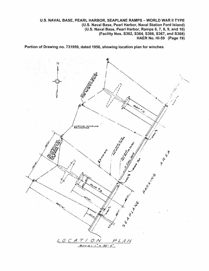
The history of seaplane use by the Navy after World War 11 is not well documented. A historian of patrol aviation, which in the early decades was based almost entirely on seaplanes, credits the global nature of WWII for that branch's transformation "from slow seaplanes to fast, heavily armored and armed, long-range, multi-engine strike aircraft" (Roberts [1996]: xi). However, seaplanes continued to be used for some purpose at NAS Pearl Harbor until at least 1956. A set of four drawings (nos. 731941, 731942, 731959, and 731960) was made then, showing the installation of winches and other equipment on either side of Facility Nos. S367 and S368 (Ramps 9 and 10), with a location plan indicating that these were to be used to bring the planes up the ramps, tail first. The drawing, included in this report, shows the tails of the planes were as wide as the 50' ramps, and the wings of the planes were much wider than the ramps. Following the disestablishment of the air station on Ford Island in 1962, trees have grown along the shoreline next to the relatively narrow WWII ramps, which would prevent the use of such large seaplanes.
A drawing (no. 975158) shows that repairs were made to Facility Nos. S367 and S368 (Ramps 9 and 10), sometime after WWII. The drawing
U.S. NAVAL BASE, PEARL HARBOR, SEAPLANE RAMPS - WORLD WAR II TYPE (U.S. Naval Base, Pearl Harbor, Naval Station Ford Island)
(U.S. Naval Base, Pearl Harbor, Ramps 6, 7, 8, 9, and 10) (Facility Nos. S362, S364, S366, S367, and S368)
Sources:
HAER No. Hl-59 (Page 9)
date is perhaps after closure of the Ford Island air station, since the title block reads "U.S. Naval Air Station, Barbers Point." A small area approximately 25' in length, about 1' deep, and about 3' wide had been scoured out from the south side of both of the ramps, just above the mean low water line. This erosion was repaired with rip-rap fill (irregular pieces of rock). Other changes to the seaplane ramps and parking areas, such as the trenches for utility lines, have not been documented in drawings filed under the ramps' facility numbers. For instance, a 1997 aerial photo indicates that utility lines run from the corner of the 1991 brig (Facility No. 462) to the north side of Ramp 10 (Facility No. S368), which may be the reason for the additional curb constructed about 1 O' inside the original runway curb.
Copies of drawings on microfiche cards for these WWII seaplane ramps were located in the Plan Files of the Naval Facilities Engineering Command, Pacific. These include five June 1940 drawings (nos. 141488 to 141491 and 142053), a 1941 drawing (no. 2721) of Facility No. S362, a 1955 drawing (no. 672314) that has profiles of all the seaplane ramps, and four 1956 drawings (nos. 731941, 731942, 731959, and 731960) that show installation of winches at Facility Nos. S367 and S368. One repair drawing (no. 975158) was found in the Plan Files of the Public Works Center, along with copies of the above drawings.
Anderson, Lisa and Katharine Bouthillier 1996 Final Report: Assessment and Analysis of Historic Properties
at Hickam Air Force Base, Honolulu, Hawai'i for Preparation of a Historic Preservation Plan. Prepared for the U.S. Army Corps of Engineers. Ogden Environmental and Energy Services Co., Inc.: Honolulu.
Contractors Pacific Naval Air Bases n.d. Technical Report and Project History, Contracts NOy-3550
and NOy-4173. On microfiche at library of Naval Facilities Engineering Command, Pacific.
Dwyer, Larry 2003 "Mitsubishi A6M Zero-Sen, Japan" and "Aichi D3A (Val) -
Japan" entries in aircraft index of Aviation History On-Line Museum, at www.aviation-history.com/mitsubishi/zero.html, accessed 8/16/2005.
Fourteenth Naval District 1940 Naval Air Station, Pearl Harbor, Ford Island, Conditions as of
June 30, 1940. Map no. V-N1-120. Filed under RG 71 1405-3-33 at Cartographic Section, National Archives II, College Park, Maryland.
U.S. NAVAL BASE, PEARL HARBOR, SEAPLANE RAMPS - WORLD WAR II TYPE (U.S. Naval Base, Pearl Harbor, Naval Station Ford Island}
(U.S. Naval Base, Pearl Harbor, Ramps 6, 7, 8, 9, and 10) (Facility Nos. S362, S364, S366, S367, and S368}
HAER No. Hl-59 (Page 10)
1942 Naval Air Station, Pearl Harbor, Ford Island, Conditions as of June 1, 1942. Map no. 509. Provided by Jeffrey Dodge, Naval Facilities Engineering Command, Hawaii.
1943 Pearl Harbor, T.H. Naval Air Station, Showing Conditions on June 30, 1943. Map no. V-N1-129. Copied from Fourteenth Naval District map book at Archives of Naval Facilities Engineering Command, Port Hueneme, California.
Historical Section, Fourteenth Naval District [1945] Administrative History of the Fourteenth Naval District and the
Hawaiian Sea Frontier. Typescript report in Library of Naval History Center, Navy Yard, Washington, D.C.
Matsuura, Joao Paulo Juliao 1997 "Nakajima B5N" entry of WWII Imperial Japanese Naval
Aviation Page, at http://www.combinedfleet.com/ijna/b5n.htm, accessed 11/16/2005.
Morgan, Joe H. n.d. From Fear to Forgiveness: An Autobiographical Essay of the
Author's Personal Experiences on December 7, 1941. Selfpublished pamphlet provided to Ann Yoklavich during interview on December 1, 1999.
National Archives 11 1941 Photos dated 1 March 1941 (PH No. 314352, in RG 71-CA-
153E), 10 October 1941 (No. 80-G-279375), 5 November 1941 (PH No. 315614, in RG 71-CA-153E), and 8 December 1941 (No. 80-G-32505), in Still Photo Section, College Park, Maryland.
Naval Air Station, Pearl Harbor [1945] Typescript history of Naval Air Station, Pearl Harbor, in binder
with photos of Ford Island, including aerial photo no. 114121 dated 30 January 1941. Loaned to Jeffrey Dodge, Naval Facilities Engineering Command, Hawaii.
Naval Historical Center 1941 Attack photo taken from Japanese plane, dated 12/7/1941, at
http://www.history.navy.mil/photos/images/h50000/h50930.jpg accessed on 11/28/2005.
Office of the Chief of Naval Operations 1947 U.S. Naval Aviation in the Pacific. United States Navy:
[Washington, D.C.]
U.S. NAVAL BASE, PEARL HARBOR, SEAPLANE RAMPS - WORLD WAR II TYPE (U.S. Naval Base, Pearl Harbor, Naval Station Ford Island)
(U.S. Naval Base, Pearl Harbor, Ramps 6, 7, 8, 9, and 10) (Facility Nos. S362, S364, S366, S367, and S368)
HAER No. Hl-59 (Page 11)
Pedrotty, Michael A. et al. 2001 Historical and Architectural Overview of Military Aircraft
Hangars: A General History, Thematic Typology, and Inventory of Aircraft Hangars Constructed on Department of Defense Installations. Prepared for the U.S. Air Force, Air Combat Command. U.S. Army, Construction Engineering Research Laboratory: Champaign, Illinois.
Roberts, Michael D. [1996] Dictionary of American Naval Aviation Squadrons, Vol. 2.
Naval Historical Center: Washington, D.C.
U.S. Army Museum of Hawaii 1942 Aerial photo of Ford Island dated 21 May 1942 (USAMH
# 160).
U.S. Naval Station, Pearl Harbor 1922 Roads and Walks at Naval Air Station, Ford Island, General
Layout. Map dated April 12, 1922, no. V-27. On microfiche card at Plan Files of Naval Facilities Engineering Command, Pacific.
U.S. Navy 1995 P-164, Detailed Inventory of Naval Shore Facilities, Station,
Pearl Harbor. In library of Naval Facilities Engineering Command, Pacific.
U.S. Navy, Bureau of Yards and Docks 1947 Building the Navy's Bases in World War II: History of the
Bureau of Yards and Docks and the Civil Engineer Corps 1940-1946, Volume II. Washington, D.C.: U. S. Government Printing Office. ·
Woodbury, David 0. 1966 Builders for Battle: How the Pacific Naval Air Bases Were
Constructed. E.P. Dutton and Company, Inc.: New York.
Yates, W. Paul 1936 Aviation in Hawaii. Paradise of the Pacific Press: Honolulu.
Project Information: Commander Navy Region (COMNAVREG) Hawaii has embarked on a program of documentation of historic properties within its area of responsibility, with the goal of recording historic information about each property and establishing its context of significance. This information will assist COMNAVREG Hawaii in the appropriate management of these properties, be it routine repair and maintenance for continuing use, rehabilitation for continuing use I adaptive reuse, or demolition. At this
U.S. NAVAL BASE, PEARL HARBOR, SEAPLANE RAMPS - WORLD WAR II TYPE (U.S. Naval Base, Pearl Harbor, Naval Station Ford Island)
(U.S. Naval Base, Pearl Harbor, Ramps 6, 7, 8, 9, and 10) (Facility Nos. S362, S364, S366, S367, and S368)
HAER No. Hl-59 (Page 12)
time, specific action that may affect these facilities has not been determined. This report was prepared under a Historic Preservation Services contract (N62742-97-D-3502) awarded to AMEC Earth and Environmental, the prime contractor, by the U.S. Navy, Naval Facilities Engineering Command. The contract was funded through the Cultural Resources Program of COMNAVREG Hawaii. The photographic documentation was undertaken by David Franzen, of Franzen Photography. Location maps were made by Nestor Beltran of NAB Graphics. Between 1999 and 2001, the field work was done and the draft of this report was written by Dot Dye, AMEC Earth & Environmental, Inc. The report was rewritten in 2005 by Mason Architects, Inc.
U.S. NAVAL BASE, PEARL HARBOR, SEAPLANE RAMPS - WORLD WAR II TYPE (U.S. Naval Base, Pearl Harbor, Naval Station Ford Island)
(U.S. Naval Base, Pearl Harbor, Ramps 6, 7, 8, 9, and 10) (Facility Nos. 5362, 5364, 5366, 5367, and 5368)