dep west Virginia department of environmental protection Office of Oil and Gas 601 57"' Street, S.E. Charleston, WV 25304 (304) 926-0450 fax: (304) 926-0452 Harold D. Ward, Cabinet Secretary www.deD.wv.gov Tuesday, February 16, 2021 WELL WORK PERMIT Horizontal 6A / New Drill SWN PRODUCTION COMPANY, LLC POST OFFICE BOX 12359 SPRING, TX 773914954 Re: Permit approval for JOHN GOOD JR BRK 40IH 47-009-00327-00-00 This well work permit is evidence of permission granted to perform the specified well work at the location described on the attached pages and located on the attached plat, subject to the provisions of Chapter 22 of the West Virginia Code of 1931, as amended, and all rules and regulations promulgated thereunder, and to any additional specific conditions and provisions outlined in the pages attached hereto. Notification shall be given by the operator to the Oil and Gas Inspector at least 24 hours prior to the construction of roads, locations, and/or pits for any permitted work. In addition, the well operator shall notify the same inspector 24 hours before any actual well work is commenced and prior to running and cementing casing. Spills or emergency discharges must be promptly reported by the operator to 1-800-642-3074 and to the Oil and Gas Inspector. Please be advised that form WR-35, Well Operators Report of Well Work is to be submitted to this office within 90 days of completion of permitted well work, as should form WR-34 Discharge Monitoring Report within 30 days of discharge of pits, if applicable. Failure to abide by all statutory and regulatory provisions governing all duties and operations hereunder may result in suspension or revocation of this permit and, in addition, may result in civil and/or criminal penalties being imposed upon the operators. Per 35 CSR 4-5.2.g this permit will expire in two (2) years from the issue date unless permitted well work is commenced. If there are any questions, please feel free to contact me at (304) 926- 0450. Operator's Well Number: Farm Name: U.S. WELL NUMBER: Horizontal 6A Date Issued: JOHN 90OD JRJBRK 40 1H JOHhJfTRATHga GOOD JR Iljj 47-009-00327-00-00 New Drill 2/16/2021 Promoting a healthy environment.
Transcript
dep
west Virginia department of environmental protection
Office of Oil and Gas
601 57"' Street, S.E.Charleston, WV 25304
(304) 926-0450fax: (304) 926-0452
Harold D. Ward, Cabinet Secretarywww.deD.wv.gov
Tuesday, February 16, 2021
WELL WORK PERMIT
Horizontal 6A / New Drill
SWN PRODUCTION COMPANY, LLC
POST OFFICE BOX 12359
SPRING, TX 773914954
Re: Permit approval for JOHN GOOD JR BRK 40IH47-009-00327-00-00
This well work permit is evidence of permission granted to perform the specified well work at the location describedon the attached pages and located on the attached plat, subject to the provisions of Chapter 22 of the West VirginiaCode of 1931, as amended, and all rules and regulations promulgated thereunder, and to any additional specificconditions and provisions outlined in the pages attached hereto. Notification shall be given by the operator to theOil and Gas Inspector at least 24 hours prior to the construction of roads, locations, and/or pits for any permittedwork. In addition, the well operator shall notify the same inspector 24 hours before any actual well work iscommenced and prior to running and cementing casing. Spills or emergency discharges must be promptly reportedby the operator to 1-800-642-3074 and to the Oil and Gas Inspector.
Please be advised that form WR-35, Well Operators Report of Well Work is to be submitted to this office within90 days of completion of permitted well work, as should form WR-34 Discharge Monitoring Report within 30 daysof discharge of pits, if applicable. Failure to abide by all statutory and regulatory provisions governing all dutiesand operations hereunder may result in suspension or revocation of this permit and, in addition, may result in civiland/or criminal penalties being imposed upon the operators.
Per 35 CSR 4-5.2.g this permit will expire in two (2) years from the issue date unless permitted well work iscommenced. If there are any questions, please feel free to contact me at (304) 926- 0450.
Operator's Well Number:Farm Name:
U.S. WELL NUMBER:
Horizontal 6A
Date Issued:
JOHN 90OD JRJBRK 40 1HJOHhJfTRATHga GOOD JR Iljj47-009-00327-00-00
New Drill
2/16/2021
Promoting a healthy environment.
API Number:
PERMIT CONDITIONS
West Viixiiiia Code $ 22-<A-S<<l) aUows the Office of Oil and Oss to place specific conditiona upon thispcniiit Pennit conditions have the same effect as law. Failure to adhere to the sneeifiednd^lfconditions mav result in enforcement action.
CONDITIONS
1. This (Hrqx)8ed activity may require permit coverage fimn the United States Army Coips of ̂igineeis(USAGE). Through diis pomi^ you are heieby bebg advised to consult udtii USAGE regarding this proposedactivtti'.
2. If the operator encountm an unanticipated void, or an anticipated void at an unanticquded dqith, the opentorshall notify tiie inqiectOT within 24 hours. Modificaticms to ̂ casing inogram may be necessary to crunplywith W. Va. Code§ 22-6A-Sa (12), uditoh requires drilling to a minimum depth of thirty fitot below thebottom of the void, and installing a minimum of twenty (20) feet of casing. Under no circumstance shoulddie operator drill more than one hundred (100) feet below the bottom of the void m install less than twenty(20) feet of casing bdow the bottom of the void.
3. When compacting fills, each lift before comptmtion shall not be more than 12 indies in and tiiemoisture content of tiie fill matmal shall be within limits as detoinined by the Standaid Proctor Density testof tiie actual soils used in specific engineered fill, ASTM D698, Standaid Test M^od for LaboratmyCmnpaction Charactmstics of Soil Usii^ Standaid Effort, to achieve 95 % compaction of the optimumdensity. Each lift shall he tested for compaction, with a minimum of two tests per lift per acre of fill. All testresults shall be maintained on she and available for review.
4. Operator shall install signage per § 22-6A-8g (6) (B) at all source water locations included in their approvedwater management plan within 24 hours of water management plan activation.
5. Oil and gas water suppfy wells will be registered with (he Office of Oil and Gas and all such wells will beconstructed and plugged in accoidande witii the standards of the Bureau for Public Healtii sm forth in itsLegislative rule mititied fFater Well Regulations. 64 C.S.R. 19. Operator is to contact tiie Bureau of PublicEtealtii regarding pmmit requiimnents. In lieu of plugging, the opmator may transfer tiie well to tiie sur&ceowner upon agremnmit of tiie parties. All drinking water wells witiiin fifiemi hundred feet of the water supph'well shall be flow tested by tiie operator upon request of the drinking well owner prior to operating the watersu|q>fy well.
6. Pursuant to the lequiiements pertaining to the sampling of domestic water siqiply wells/qirings the npftrfltorshall, no later tiiaii tiurty (30) days after receipt of analytical data provide a written copy to the Chief and anyof the users vho may have requested sudi analyses.
7. 24 hours prior to the initiation of tiie completion process tiie opmator shall notify the Chief or his
8. During the completion process the operator shall monitor annular inessuies and rqiort any anomaly noticed tothe diief or his designee immediatefy.
9. If any explosion or othm accidmit causing loss of life or smious personal injury occurs in or about a well orwell work on a well, tiie well operator or its contractor shall give notice, stating the paiticulan of themqiiosion or nccidmt, to tiie oil and gas inspector and the Qiie^ within 24 hours of said accident.
10. During the casing aiul cmnenting process, in the evoit cmnoit does not return to tiie suifece, tiie oil and gasinspectw diall be notified witiiin 24 hours.
APINumbo:
PERMIT CONDITIONS
11.
their occuiraice: • "compi^on of any otfa^ pennitted weU work, and completion of the wefl. Sudi notice shall be inovided^soiding an onail to [email protected].
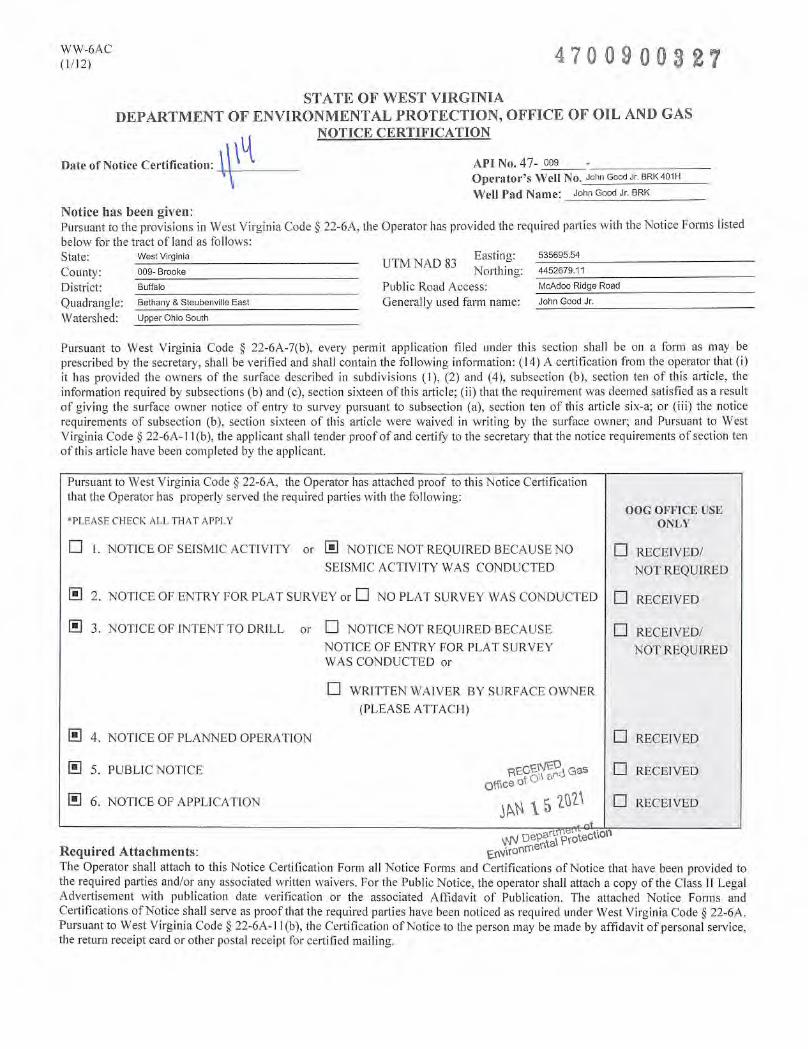
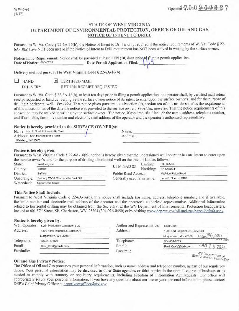
WW-6B
(04/15)
70090032API NO. 47
OPERATOR WELL NO. ■l°hnGoodJr. BRK401H
Well Pad Name: John Good Jr. BRK
STATE OF WEST VIRGINIADEPARTMENT OF ENVIRONMENTAL PROTECTION. OFFICE OF OIL AND GAS
WELL WORK PERMIT APPLICATION
1) Well Operator; SWN Production Co., LLC 494512924 009- Brooke 3-Buffalo 247- Bethany 62gOperator ID County District Quadrangle
2) Operator's Well Number: John Good Jr. BRK 401H Well Pad Name: John Good Jr. BRK
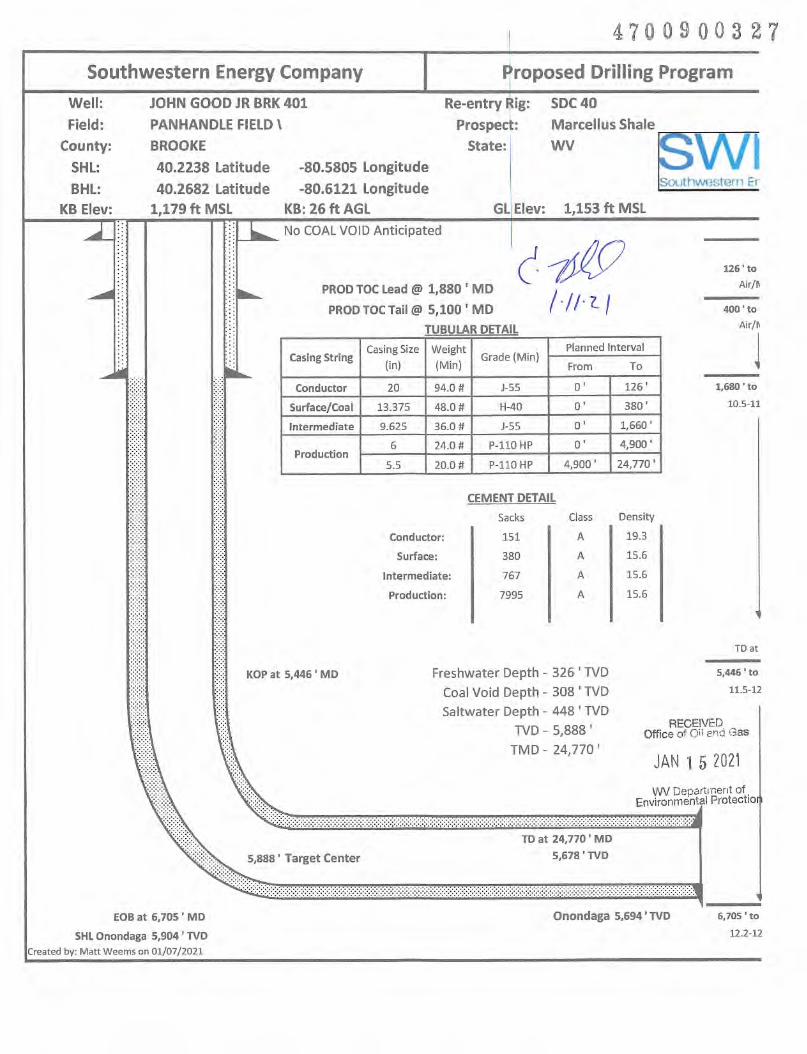
6) Existing Pad: Yes or No Yes7) Proposed Target Formation(s), Depth(s), Anticipated Thickness and Expected Pressure(s):
Target Formation- Marcellus, Up-DIp well to the North, Target Top TVD- 5853', Target Base TVD- 5904', Anticipated Thickness- 51', Associated Pressure- 3838
8) Proposed Total Vertical Depth: 5888'9) Formation at Total Vertical Depth: Marcellus10) Proposed Total Measured Depth: 24770'
11) Proposed Horizontal Leg Length: 18047.28'12) Approximate Fresh Water Strata Depths:
13) Method to Determine Fresh Water Depths: Logs on pad, John Good Jr. BRK 5H API 47-009-00114) Approximate Saltwater Depths: 448' Salinity Profile Analysis i/
ws
15) Approximate Coal Seam Depths: 308'
16) Approximate Depth to Possible Void (coal mine, karst, other): None that we are aware of.
17) Does Proposed well location contain coal seamsdirectly overlying or adjacent to an active mine? Yes
(a) If Yes, provide Mine Info: Name:
Depth:
Seam:
Owner:
No X
•Shid Gas
15 myvuQ
Page 1 of 3
WW-6B
(04/15)API NO. 47- 009,4 70 0 9 0 0 3 2 7
John Good Jr. BRK 401HOPERATOR WELL NO.
Well Pad Name: John Good Jr. BRK
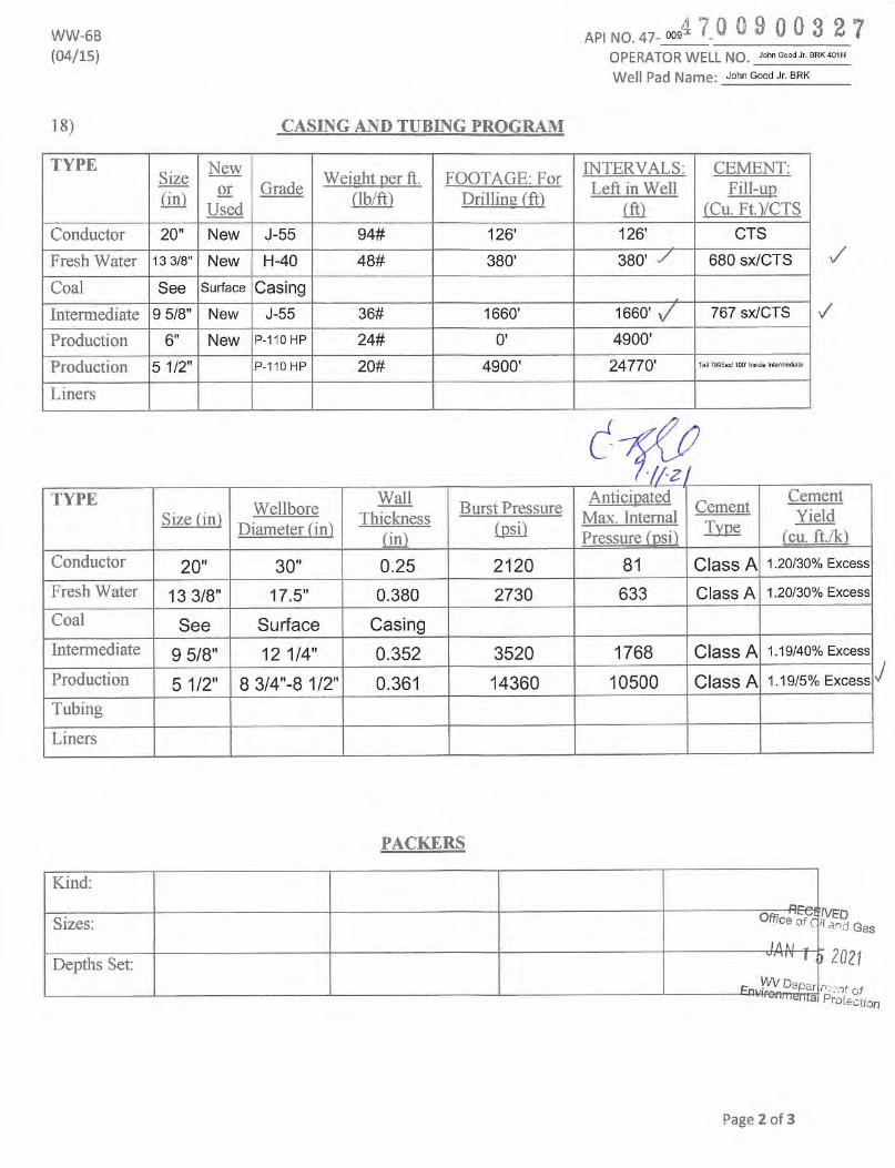
18) CASING AND TUBING PROGRAM
TYPESize
On)
New
Used
GradeWeight ner ft.
(lb/ft)FOOTAGE: For
Drilling (ft)
INTERVALS:
Left in Well
m
CEMENT:
Fill-uptCu. Ft.VCTS
Conductor 20" New J-55 94# 126' 126' GTS
Fresh Water 13 3/8" New H-40 48# 380' 380' 680 sx/CTS
Production 5 1/2" P-110 HP 20# 4900' 24770' Tai 79958X/100* Inside Intermedate
Liners
/
TYPE
Size tiniWellbore
Diameter fin)
Wall
Thickness
(in)
Burst Pressure
(psi)
Anticinated
Max. Internal
Pressure fnsi)
Cement
Tvoe
Cement
Yield
feu. ft./k)
Conductor
oMC
bCO
0.25 2120 81 Class A 1.20/30% Excess
Fresh Water 13 3/8" 17.5" 0.380 2730 633 Class A 1.20/30% Excess
Coal See Surface Casing
Intermediate 9 5/8" 12 1/4" 0.352 3520 1768 Class A 1.19/40% Excess
Production 5 1/2" 8 3/4"-8 1/2" 0.361 14360 10500 Class A 1.19/5% Excess
Tubing
Liners
J
PACKERS
Kind;
'VED'' <3!^d GasSizes: Office of c
JAN I ) miDepths Set:_ WV DeparEinv/ron/Tienta nvent of
Phofeotion
Page 2 of 3
47009003WW-6B API NO. 47- oo9
(10/14) OPERATOR WELL NO. J°hnGaodJr.BRK401H
Well Pad Name: John Good Jr. BRK
19) Describe proposed well work, including the drilling and plugging back of any pilot hole:
Drill and stimulate any potential zones between and including the Benson to Marcellus. **lf we should encounter a voidplace basket above and below void area- balance cement to bottom of void and grout from basket to surface or runexternal casing packer/cementing stage tool above void interval and perform 2 stage cementing operation dependentupon depth of void. Run casing not less than 20' below void nor more than 75' below void. (*lf freshwater isencountered deeper than anticipated it must be protected, set casing 50' below and cts.) ^
20) Describe fracturing/stimulating methods in detail, including anticipated max pressure and max rate:
Well will be perforated within the target formation and stimulated with a slurry of water, sand, and chemical additives ata high rate. This will be performed in stages with the plug and pert method along the wellbore until the entire lateralhas been stimulated within the target formation. All stage plugs are then drilled out and the well is flowed back tosurface. In some instances, additional toe prep may be performed by pumping additional water in the toe of the wellprior to perforating and pumping Stage 1 to ensure that the toe guns/toe sleeves are fully open prior to pumping stage1. The well is produced through surface facilities consisting of high pressure production unites, horizontal separationunits, water and oil storage tanks. Max press and anticipated max rate- 9000 lbs @100 barrels a minute. v
21) Total Area to be disturbed, including roads, stockpile area, pits, etc., (acres): 21.91
22) Area to be disturbed for well pad only, less access road (acres):
23) Describe centralizer placement for each casing string:
All casing strings will be ran with a centralizer at a minimum of 1 per every 3 joints of casing.
24) Describe all cement additives associated with each cement type: Gas
See Attachment *** | g 2021
25) Proposed borehole conditioning procedures:
All boreholes will be conditioned with circulation and rotation for a minimum of one bottoms up andcontinuing until operator is satisfied with borehole conditions.
*Note: Attach additional sheets as needed.
Page 3 of 3
470 0 9 00 3 27
CEMENT ADDITIVES
INTERVAL
SCHLUMBERGER
PRODUCT
NAME
BJ
PRODUCT
NAME
NEXTIER
PRODUCT
NAME PRODUCT USE CHEMICAL NAME CAS-Number
SURFACE
(FRESHWATER)
up to 3%
INTEGRA
SEALaeoo LOST CIRC MATERIAL CELLOPHANE FLAKES 9005-81-6
SHL Onondaga 5,904 ' TVDCreated by: Matt Weems on 01/07/2021
Onondaga 5,694' TVD 6,705 ■ to
12.2-12
John Good Jr. BRK401H AOR
API Operator Status Latitude Longitude Vertical TD Producing Formation Producing Zones Not Perforated
47-09-00113 SWN PRODUCTION COMPANY, LLC ACTIVE 40.223907 -80.580720 MARCELLUS
47-09-00124 SWN PRODUCTION COMPANY, LLC ACTIVE 40.223944 -80.580734 MARCELLUS
47-09-00188 SWN PRODUCTION COMPANY, LLC ACTIVE 40.223796 -80.580680 MARCELLUS
47-09-00189 SWN PRODUCTION COMPANY, LLC ACTIVE 40.223811 -80.580611 MARCELLUS
47-09-00196 SWN PRODUCTION COMPANY, LLC ACTIVE 40.223833 -80.580693 MARCELLUS
47-09-00197 SWN PRODUCTION COMPANY, LLC ACTIVE 40.223848 -80.580624 MARCELLUS
47-09-00198 SWN PRODUCTION COMPANY, LLC ACTIVE 40.223870 -80.580707 MARCELLUS
%<D
&SBlU OGC 0)o
c=>
%
%
^"S0)^
co-p
&l
I
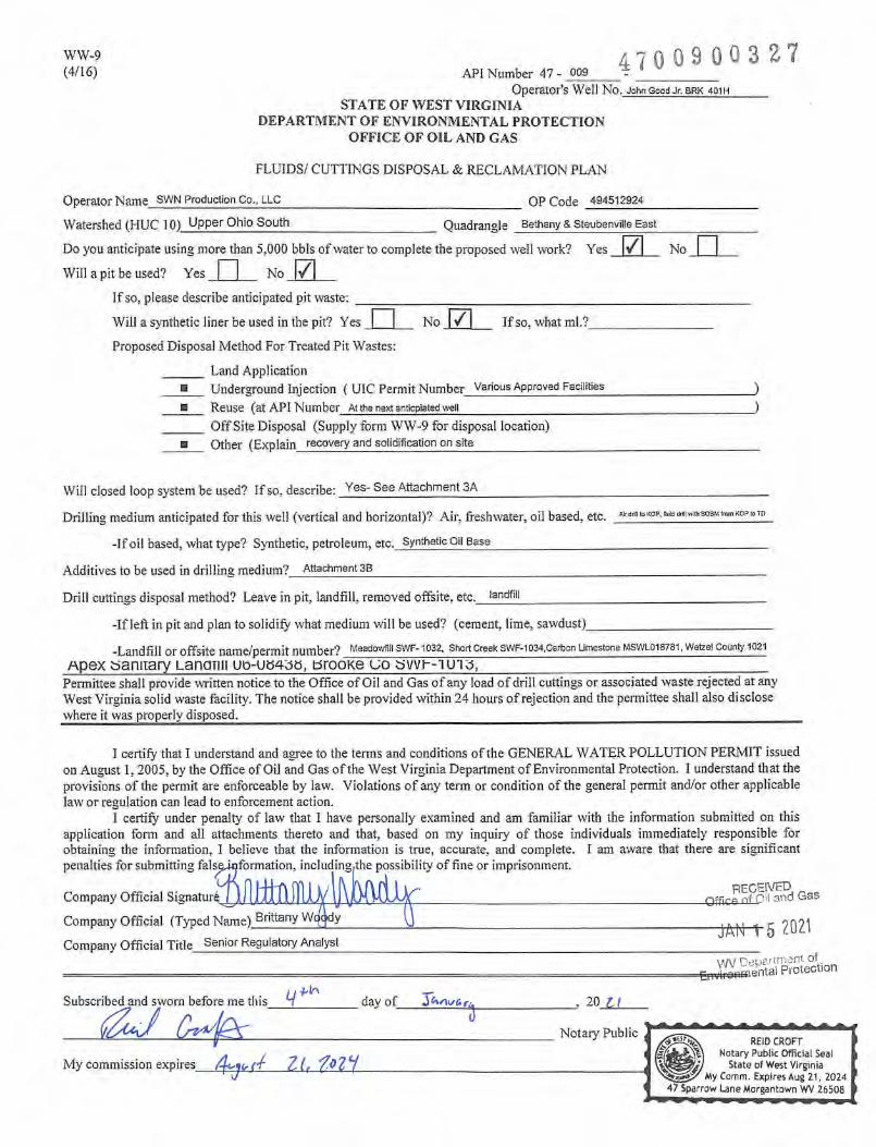
WW-9
(4/16) API Number 47 - 009
4700900327Operator's Well No. John Good Jr. BRK 401H
STATE OF WEST VIRGINIA
DEPARTMENT OF ENVIRONMENTAL PROTECTION
OFFICE OF OIL AND GAS
FLUIDS/ CUTTINGS DISPOSAL & RECLAMATION PLAN
Operator Name SWN Production Co., LLC OP Code 494512924
Watershed (HUC 10) Upper Ohio South Quadrangle Bethany & Steubenville East
Do you anticipate using more than 5,000 bbls of water to complete the proposed well work? Yes li/l No
If so, please describe anticipated pit waste: _
Will a synthetic liner be used in the pit? Yes
No
If so, what ml.?No
Proposed Disposal Method For Treated Pit Wastes:
Land Application" Underground Injection ( UlC Permit Number Various Approved FacilitiesU Reuse (at API Number At the next anticplaled well
Off Site Disposal (Supply form WW-9 for disposal location)
Other (Explain recovery and solidification on site
Will closed loop system be used? If so, describe: Yes- See Attachment 3A
Drilling medium anticipated for this well (vertical and horizontal)? Air, freshwater, oil based, etc.
-If oil based, what type? Synthetic, petroleum, etc. Synthetic Oil Base
Additives to be used in drilling medium? Attachment SB
Drill cuttings disposal method? Leave in pit, landfill, removed offsite, etc. landfill
-If left in pit and plan to solidify what medium will be used? (cement, lime, sawdust)_
-Landfill or offsite name/permit number? Meadowfill SWF- 1032, Short Creek SWF-1 034,carbon Limestone MSWL018781, Webel County 1021Apex aaniiary LanaTiii ub-U84Jo, mooKe uo uvvi—Permittee shall provide written notice to the Office of Oil and Gas of any load of drill cuttings or associated waste rejected at anyWest Virginia solid waste facility. The notice shall be provided within 24 hours of rejection and the permittee shall also disclosewhere it was properly disposed.
I certify that I understand and agree to the terms and conditions of the GENERAL WATER POLLUTION PERMIT issuedon August 1,2005, by the Office of Oil and Gas of the West Virginia Department of Environmental Protection. I understand that theprovisions of tlie permit are enforceable by law. Violations of any term or condition of the general permit and/or other applicablelaw or regulation can lead to enforcement action.
I certify under penalty of law that I have personally e.xamined and am familiar with the information submitted on thisapplication form and all attachments thereto and that, based on my inquiry of those individuals immediately responsible forobtaining the information, I believe that the information is true, accurate, and complete. I am aware that there are significantpenalties for submitting falsejqformation, includingfthe possibility of fine or imprisonment.
Company Official Signature
Company Official (Typed Name) Brittany Wqjqdy
receivedOffi^p nf Oil and eas
Company Official Title Senior Regulatory /VialystVW Depf'^'tnient ofEnvironmental Protection
Subscribed and sworn before me this,flA
day of___3fv»nw£^ 20 U
Notary Public
My commission expires_ 4.^^,4 ZLf.n'iREID CROFT
Notary Public Official SealState of West Virginia
My Comm. Expires Aug 21, 2024Sparrow Lane Morgantown WV 26508
■r
Form WW-9
SWN Production Co., LLC
4700900327Operator's Well No. GoodJr. BRK 401H
Proposed Revegetation Treatment: Acres Disturbed
a. determined by pHies.min.2 Or to coiTect to pH 8-63
Fertilizer type 10-20-20
Fertilizer amount 800/500
Mulch Hay/Straw
lbs/acre
Tons/acre
Prevegetation pH
Seed Mixtures
Temporary
Seed Type
Attachment 30
lbs/acre
Permanent
Seed Type lbs/acre
Attach:
Maps(s) of road, location, pit and proposed area for land application (unless engineered plans including this info have beenprovided). If water from the pit will be land applied, include dimensions (L x W x D) of the pit, and dimensions (L x W), and area inacreage, of the land application area.
Photocopied section of involved 7.5' topographic sheet.
Plan Approved by:
Comments:
Title:Oil & Gas Inspector
Field Reviewed? ( ̂ J Yes
Date:
JNo
RiCEIVEDOffice of Oil and Gas
JAN I 5 20^^ofE„rsa'fsi.odon
4700900327
Attachment 3A
CLOSED LOOP SYSTEM
The closed loop system is designed to eliminate the use of reserve pits by providing a higher level of
solids control processing and using steel pits for capture of drill cuttings. The cuttings are then
processed to achieve landfill requirements before hauling to approved landfills. The liquids are
processed to recycle into the active mud system or to transfer to onsite temporary storage as needed.
The closed loop system consists of several sets of a shale gas separator (often called a 'methana'),several banks of solids shakers, high speed centrifuges (1 or 2) used to process the fluid portion of the
mud system to remove low gravity solids, low speed centrifuge used for barite recovery in high weightliquid drilling systems, a dewatering system (for air intervals and if freshwater mud systems are in use)used to further clean liquids by flocculation and additional mechanical separation, associated open toptanks for processing liquids and capturing solids for disposal, and transfer pumps to move fluids throughthe processes. There is an area adjacent to the cuttings tanks (Red Zone) where a track hole is utilized torecover the processed cuttings for loading into containers for hauloff. (See attached schematic of ageneric closed loop system layout)
Below are discussions of the processes used when drilling the air interval or liquids interval.
AIR DRILLING INTERVALS
During air drilling operations, flow from the rig will pass down the flowline to the Shale Gas Separater(sometimes called a methane) where gas and liquids/solids are separated. Gas is sent to the flarescrubber tank and is flared at the flare stack. Solids and fluids pass across a shaker system to separate
solids from liquids. Solids pass into the cuttings tanks where they are captured for drying and hauloff toan approved landfill site. Liquids fall into a shaker tank and are collected by a centrifugal pump to beprocessed by the high speed centrifuge to further separate liquids and solids. Solids are then dumpedinto the cuttings tank for drying and hauloff. Liquids are further processed to remove additional lowgravity solids before being reused or transferred to onsite storage.
LIQUIDS DRILLING (FRESHWATER, BRINE, SOBM)
When drilling is converted to liquids drilling, the shale gas separator and associated shaker tank arebypassed, and the liquids system is processed over the primary and drying shaker systems. Cuttingsdrop into the cuttings tank for additional processing. Any recoverable associated liquids attached to thecutting are recovered out the tank and processed through the low gravity (high speed) and bariterecovery centrifuges (low speed) to further remove low gravity solids and to recover barite for reuse inthe mud systems.
receivedOffice of 00 and Gas
Enviroi
JAN \ 5 2021
EXAMPLE SCHEMATIC FOR CLOSED LOOP SOLIDS CONTROL SYSTEM
4700900327
CO
Z3
O
03
O
OCO
JO
"oO)
Dewabef Tfatw
duirTa —
m
received ̂Office of Oil ai^.d ^as
JAN 1 5 2021
WV DepartmenT ofEnvironmental Protection
4700900327
Attachment 3B
Drilling Mediums
Surface/CoaUif present)/Freshwater Intervals;
Air
Freshwater (if needed based on conditions)
Intermediate/Coal (if present):
Air
Production Hole;
Air
Synthetic Oil (Base Fluid for mud system)
Barite
Calcium Chloride
Lime
Organophilic Bentonite
Primary and Secondary Emulsifiers
Gilsonite
Calcium Carbonate
Friction Reducers
RECEl^/EDOffice Oil and Gas
JAN 1 5 2021
WV Department ofEnvironmental Protection
Rev. 6/11/2018
Attachment 3C
>10^ #03 27LO t; fO
WC. CO
swnSouthwestern Energy'
WVD Seeding Specification
RE iffOce cJAN
DVWi Envlronm
t
To Order Seed contact Lyndsl Eddy Flippo office 570-996-4271 cell 501-269-5451 [email protected] (please allow 7 to 10 days for delivery)
Every 622 linear feet in a 70' ROW/LOD, you should be using (2) 501b bags of seed, (4) 501bbags of fertilizer and (80) 501b bags of Lime (2x seed in winter months + 501b WinterWheat/ac).
Redtop
Golden TIckseed
Maryland Senna
Showy TIckseed
Fox Sedge
Soft Rush
Woolgrass
Swamp Verbena
5%
5%
5%
5%
2.5%
2.5%
2.5%
2.5%
Special Considerations; Apply @ 25lbs per acre Apply @ 50lbs per acre
Landowner Special Considerations Including CREP program participants require additional
guidance that Is not given here. Discuss these requirements with SWN supervision at the
beginning of the project to allow time for special seed delivery.
April 16th- Oct. 14th Oct. 15th- April 15th
NO FERTILIZER OR LIME INSIDE WETLAND LIMITS
Rev. 1/13/2020
470 09 00 3 27
MARCELLUS WELL DRILLING PROCEDURES
AND
WELL SITE SAFETY PLAN
swnProduction Company"
SWN Production Company, LLC1300 Fort Plerpont Drive, Suite 201Morgantown, West Virginia 26508
API NO. 47-XXX-XXXXX
WELL NAME: John Good Jr. BRK 401H
Bethany & Steubenville East QUADBuffalo DISTRICT
Brooke COUNTY, WEST VIRGINIA
Submitted by:
Name: Brittanv Woody
Title: Senior Regulatory Analyst
Approved b
Name:
Title: C)'i gf?/ Qc't
Approved by:
Name:
Title:
Date: 12/16/2020
SWN Production Co., LLC
Date ■. JdtLL
Date:
RECEIVEDOffice of Oil and GaS
JAN 1 5 2021
V7V Deparirnent of.Environmental Protection
SWN PRODUCTION COMPANY, LLC - CONFIDENTIAL
■ 'V.
.y-\m'W
B3'20j1i1I800000000
03IB33DO60QOa0.0a0
03IB3800Di100.0000
. ■• f- W-U.GHNLG'BQD
«
1' i
RAWE0RD]M'i9Ri!INIGSRYSnOiYIH)
031B-3?(00530.0
SiTARViCfGSlfjC),ljl,SiTiRjESyy
03!B07i00530.00.00000,
»• - ■ .f- % 'V" * :^'i I+' "'K- j% ,*"■
1 in = 417 ft
0 0.025 0.05 0.1 0.15 0.2
Coordinate System: NAD 1983 UTM Zone 17NUnits: WIeter
BOTTOM HOLE LOCATION (BHL):GEOGRAPHIC (NAD83):LATITUDE: 40.2681 68'LONGITUDE: -80.612053' GRAPHIC SCALE IN FEETNOTES ON SURVEY1. SURFACE AND ROYALTY OWNER INFORMATION AND THEIR
BOUNDARIES SHOWN HEREON WERE PLOTTED FROM DEEDS AND/ORTAX PARCEL MAPS PROVIDED BY CUENT AND/OR FIELD LOCATIONS.
2. THIS PLAT DOES NOT REPRESENT A BOUNDARY SURVEY OF THEPARCELS SHOWN HEREON.
3. ALL INSETS ARE GRID NORTH UNLESS OTHERWISE DEPICTED.
LATITUDE: 40'17'39'' BOTTOM HOLE (2000' SCALE)NOTES ON SURVEY
1. COORDINATE SYSTEM IS UTM NAD 83 DATUM. ZONE 17. U.S. FOOTAND WELL COORDINATES ESTABLISHED USING SURVEY GRADE GPS.
2. SURFACE AND ROYALTY OWNER INFORMATION AND THEIR BOUNDARIES
SHOWN HEREON WERE PLOHED FROM DEEDS AND/OR TAX PARCEL MAPSPROVIDED BY CLIENT AND/OR FIELD LOCATIONS.
3. THIS PLAT DOES NOT REPRESENT A BOUNDARY SURVEY OF THE PARCELS
SHOWN HEREON.
4. NO DWEUJNGS OR BUILDINGS WITHIN 625 FEET OF PROPOSED
CENTER OF PAD5. NO PERENNIAL STREAMS. LAKES. PONDS. RESERVOIRS OR
WCTLANDS WITHIN 100 FEET OF THE UMITS OF DISTURBANCE.
NO NATURALLY PRODUCING TROUT STREAM WITHIN 300 FEET OF
THE LIMITS OF DISTURBANCE.
7. NO WATER WELLS OR DEVELOPED SPRINGS WITHIN 250 FEET OF
PROPOSED WELL
LO
00
LINE BEARING DISTANCE
LI N20-53'00"W 1683.28'
L2 S25'00'06"E 714.74'
oCD
LOCD
PROPOSED
BOTTOM
HCV.E
INSET "V"
WELL REFERENCE
DETAIL N.T.S5/8'IRON 0PIN SET "A""
@
INSET
INSET
INSET5/8' IRON*PIN SET'S"
JOHN GOOD JR BRK
401H
@INSET
3000
EXISTING WELLS
WITHIN 3000'
SCALE: 1-=30QO-
(D
PROPOSED
HOLE
SURFACE HOLE LOCATION SHL 2014.65
METERS)
30003000
GRAPHICSTATE O.-COMPANY:
SWN
'UTM (NAD83, ZONE 17,NORTHING: 4452679.1 1EASTING: 535695.54
LANDING POINT LOCATION (LPL):
UTM (NAD83, ZONE 17NORTHING: 4452519.51
EASTING: 535102.82
BOTTOM HOLE LOCATION (BHL):
UTM (NAD83, ZONE 17, METERS)NORTHING: 4457594.09EASTING: 532985.18
I, THE UNDERSIGNED. HEREBY CERTIFY THAT THISCORRECT TO THE BEST OF MY KNOWLEDGE AND BEUEF AND SHOWSAa THE INFORMATION REQUIRED BY LAW AND RECUUT10NS ISSUEDAND PRESCRIBED BY THE DEPARTMENT OF ENVIRONMENTAL PROTECTION.
P.S. 2041 Production Company™
(+) DENOTES LOCATION OF WELL ONUNITED STATES TOPOGRAPHIC MAPS
WVDEP
OFFICE OF OIL & GAS
601 57TH STREET
CHARLESTON. WV 25034
MINIMUM
DEGREE OF
ACCURACY: 1/200
PROVEN SURVEYSOURCE OF GRADE GPS
ELEVATION: (NAVO 88. US FT)
OPERATOR'S WELL |:
API WELL #: 47STATE
JOHN GOOD JR BRK
401H
009 0D32.1COUNTY PERMIT
WELL TYPE: OIL WASTE DISPOSAL PRODUCTIONX DEEP GASXWATERSHED: UPPER OHIO SOUTH
DISTRICT: BUFFALO COUNTY: BROOKE
SUiTACE OWNER: JOHN PRATHER GOOD JR IRREVOCABLE TRUST
OIL & GAS ROYALTY OWNER: JOHN PRATHER GOOD JR IRREVOCABLE TRUST
DRILLX drill DEEPER REDRILL FRACTURE OR STIMULATE XCONVERT PLUG & ABANDON: CLEAN OUT & REPLUG I OTHER CHANGE
GOOD JOHN P III: JOHNSTON KENNETH D (SURV)GEORGE IT' ROWDY T
JAMIE L. OHLER, LESLIE OhI EH AND lOSEPHINE OHIER
LEDAK MARK St GEORGIA
FEDAK MARK & GEORGIA
STATE OF WEST VIRGINIA DEPARTMENT OF
TRANSPORTATION
HUBBARD SAMUEL HERVEY
MICHAEL SERcVlCZ AND DfcLLA J. ScREVia
SUSAN FODOS^,
TOMSHACK MATTHEW PATRICK
lOMSHACK MAi I HEW PAI KICK
JAMES E. BEST AND ANNETTE M. BES T
BEST JAMES E & ANNETTE M JTWS
ROBERT F OHLER. JR.
SCHIAPPA & COMPANY INC.
M'-.GOWAN HbHBEH 1
RECK lAYD .KKAREN S (SURVNO SI EL E [ i lNE tSUltV)
MARLIN G. CFLAWEOKD A/K/A MARLIN G. CRAWFORD. JR.MARLIN o CRAWFORD A/K/A MARLIN G. CRAWFORD, JR,
. I -^tlHV)
ihtHlNE VANu iLfci , KUR i MICHAEL YANG
i.RtL/VUNDhHMAN;
JORDAN RONALD VV & HOPE L (SURV >S TIL LWELL J AM ES E • 96-S,, Wl CK hA M CATHI J ETL
BET TY L. FERDA
DED'TCH GHEuOkY
TAX PARCEL
03 B38 001.0 J,.TAX
03-B37-053.0
3 B3 7 5.3.2
/
BETHANYPIKE
3-832-117 -i-3 832 116
"7^PIERCE RUN ROAD
3-B32G-10
3-B3209
3-B32G-8
3 B32G 7
3 B32G 6/
3 B32G 67.1
3 832-40
J_
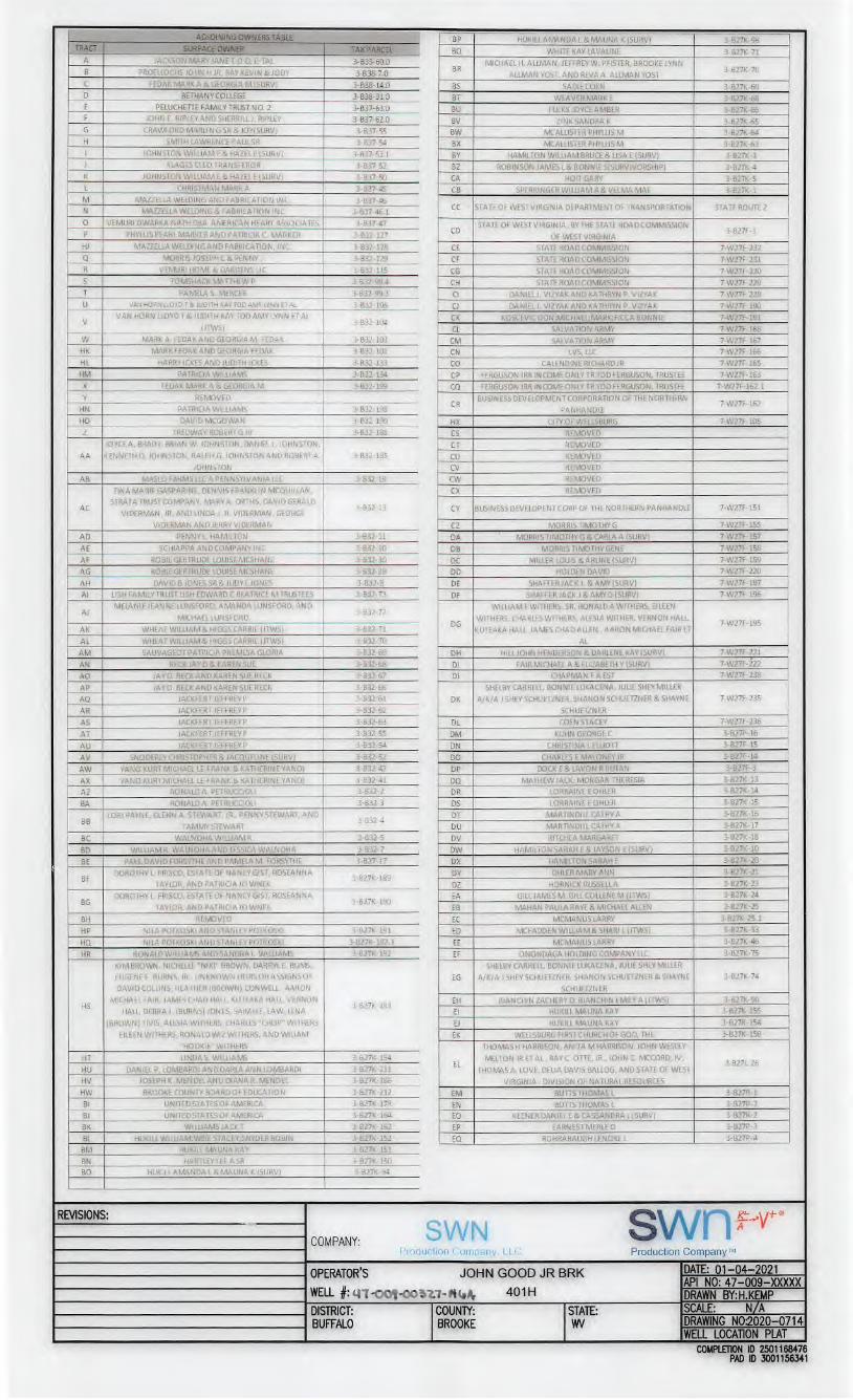
WELL BORE TABLE FOR SURFACE/ROYALTY OWNERSTRACT SURFACE OWNER TAX PARCEL
37 ROBIL GERTRUDE LOUiSl MCsHANE /38 LUKSHIN lUCINDA F & Nl^'.al.Al A (SURV) 3-B27fi-SO ^39 JOHN WAYNE STEWART 3-B27P22 y/40 KiSNER WtLllAMCLINrON 3-B27P-18 \/41 WALNOHA JOSEPH L & JANICE 3-B27P 17 l/42 WiUlAMSrvlARTHAK 3-B27P-10 ^43 WILLIAMS MARTHA K 3B27P-9
44 MACIAk. EDWARD 3-B27P-3J ✓
45 TERRY bUE GOrF 3B27P-7 y
46 SILIN tOSEPH PAUL 3-B27P-5 /
47 UNKNOWN C.WVNER 3B27KiS;i y
48 FUCIbL-.tVER:.vK J-B27K-159 y49 STATE OF WEST VIRGINIA, DIVISION Of NATURAL BUFFALO CREEK y/50 WELLSBURG FIRST CHURCH OF GOD 3-B27K-160 y51 WILLIAM HUKILL ROBIN L SN''DER AND STAGEY WISE 3-B27K-153 /
HSMICHAEL'AIR, JAMES CHAD HALL. KUIEAKA HALL, VERNON
3-B27K193EH BIANCHINZACHERY D. BlANCHIN EMILY A (JTWS) 3-B27K-90
HALL, DEBRAJ, (BURNS) JONES. SARAH E, LAW, LENA El HUKILL MAUNA KAY 3-B27K-155
(BROWN) TIVIS. Al£SIA Wl I HERS, CHARLES 'CHOP " Wl THERS. EJ HUKilL N-VLUNA KAY 3-B27K-154
EILEEN WITHERS, RONALD WIZ WITHERS. AND WHlAM EK WELLSBURG FIRST CHURCH OF 600. THE 3-B27K-158
HOOKtf WITHERS THOMAS H HARRISON. ANITA M HARRISON. JOHN WESLEY
HT LINDAS. WILLIAMS 3 B27K 194EL
MELTON JR ET AL . RAY C On£, JR.. iOHN C. MCCORO, IV,3-B27L-26
HU DANIEL P. lOMBARDl ANDDARLA ANNLOMBARDI 3-B27K 211 THOMAS A, LOVE, DELIA DAVIS BALLOG. AND STATE OF WESTHV JOSEPH K. MENDELAND DIANA R. MENDEL 3B27K-186 VIRGINIA DIVISION OF NATURAL RESOURCES
HW BROOKE COUNTY 30ARD0F EDUCATION 3-B27K 212 EM BUnS THOMAS L 3-B27R-1
Bl UNITED STATES OF AMERICA 3-B27K-178 EN BUTTS THOMAS L 3-B27P-2
BJ UNITED STATES OF AMERICA 5-B27K- lb4 EC KEENER DAN lEL E & CASSANDRA J (SURV) 3-B27R-2
BK WluLlAMb JACK 1 3 B27K 162 EP EARNEST MERLE 0 3-B27P-3
BL HUKIlL WIUiAMiWlSE STACEV:SNVDER ROBIN 3 B27K152 EQ ROHRABAUGHLENOREL 3-B27P-4
BM HUKILL MAUNA KAY 3 B27K 151
BN HARTlFYIfb ASR 3-B27K 150
BO HUK1LLAMANDAL& MAUNA K (SURV) 3 B27K 94
REVISIONS: o\/L ,c)W SJ oV \ '1 rCOMPANY: ^
Production: ! ■ . . iUI 1 , I 1 ^ L/Ompany
nPFRATflR'*; inwM nnnn ir rrk DATE: 01-04-2021API NO: 47-009-XXXXX
WLLL #:4n-O01-0O5^^-«UIV DRAWN BY: H.KEMP
DISTRICT: COUNTY STATE: SCALE: N/ABUFFALO BROOKF WV DRAWING N02020-0714
WELL LOCATION PLATCOMPLETION ID 2501168476
PAD ID 3001156341
ADJ0iMlNG0WN£RSTAfl!s6---,. i
TRACT - SURFACEOWNER "TPBIB ' TAX PARCEL ^
ER
KIM SMITH ViNSON CHFsTr R M MCCORD. THOMAS A
MCCORD, BRIAN SiAiVTER, DIRK SLUVTFR, SANDRA HALL
HARINER, THOMAS CLIFFORD, PAUL iOSEPH CLIFFORD, DONA
CLIFFORD, THOMAS H HARRISON, ANITA M HARRISON.
TRUSTEE FOR DAVID H HARRISON, JOHN C MCCORD IV.
BENEFICIARY OF TRUST, JOHN WESLEY MELTON JR, RICHARD
HUNTINGTON MELTON RAY C OTTE, JR, MARK FREEL AND
ERIC STEVEN FREEL
3-B27P-6
ES GOFF TERRY SUE 3-B27P-7
ET GOFF TERRY SUE 3 B27P-8
EU 3ETHANYPIKE VOLUNTEER -IRE DEPARTMENTINC 3-B27P-28
EV MISCH EUGENE THOMAS ' 3-B27P-24
EW KiSNtR WiLlIAMC 3-B27P-i9
EX HARF/ELl JOANNE K 3-B27P-20
EY JOANNA HARTZELL .3-B27R-49
EZ JOANNA HARTZELL 3 B27R 48
FA WILLIAMS S'IrVLN hi JESSICA (SURV.i 3-B27R-47
FB WILLIAMS SrEVEN E i JESSICA (SURVj 3-B27R-46
FC WALLACE JAMES 3-627R-43
FD lUClNDA LUKSHIN 3 827R 51
FE HARVCV MiCHAEL L & MARSHA LISURVI 3-B27R-52
FF OSSMAN ROBERT £ JR & LORRAINE 3 B27R 53
FG GEORGIANN M. DAv AND lVEREH H. DAY 3-B27R-S4
FH F.DWARDW NICHOLSON 3-B27R-82
F! FRANKE YANG 3-B27R-81
FJ LLLlOIi GARY & EVA K {SURV,> 3-B27R-80
FK ZA r LA EDWARD C:DAVID: THtODORt ETAl (SURV) 3 B27R 78
FL BE 1 MANY PIKI VOLUNIL-ERFIRE DtPARIMENT 3-B27R-79
FM St IlRl.LV HARRISON 3-632 31
FN •'•SHlEV KOVALSKl 3-DJ2 32
FO . t i iv': K-, ihl'MAS S& lENNIFERG(SURV) i-B32-33
FP ■, HIV- Rs S& JENNIFER GiSlJRV) 3-B32 34
FQ ILNN.AN r RLAINE A 3-B-;2 35
FR KOSCtViC [TON AlAN 3-B32-45
FS ROCKET EiEANOfU 3-B32-46
FT SHIRLEY HARRISON 3 B32 47
FU HARRISON RiCHARDE JR 3-B32-48
FV PRAMESA GLORIA 3-B32-49
FW STEVEN D. MARTINOAND MARYC MARTINO 3-832-53
FX STEVEN D, MARTINO AND MARY C MARTINO 3-B32-65
FY PRAIZ GARY lEL & HANNAH JANE 3-B32-74
FZ WOODBURN ERIC) 3-B32-75GA LESLIE R. OHLER AND ICSEPHINE L OHLER 3-B32-76
GB TON- A smith 3-B32-79
GC BLACKKEiTH 3-B32-80
GD BLACK CiNDv _E[ 3-B32-S1
GE TAYLOR SYLVIA 3-B32-S2GF TAYLOR WAYNE & SYLVIA (SURVl 3-B32G-66GG TERRY L STEWART AND CHARLOnt M, SLtWARL 3-B32H-J
GL REED lARRV MICHAEL DEBORAH RENEEiJiWSj 3-B32G-5
GM REED LA RRV MS. DEBORAH R (SURV) 3-&32G-b
GN STARVAGGl INDUSTRIES, iNC 3 B32G-63
GO LONG Wll 1 iAMG N OORENCt l (SURV) 3 B32G 25
6P BEi>! LUCiUt j B32G-14
GQ WIll lAMS OAVIDA 3-B32G-n
GR BRADV ' DWARD DEAN i B3.2G 12GS BRADY : DWARD DEAN 3-632-92
GT LANCASTER CARY& PATRICIA SURV 3-B32-91
GU
TRUSTEES Of THE MARY MARGARET LANCASTER TRUST (LE)GEORGIA M. FEDAK. MARIE J, DOWDEN, WALTER E.
LANCASTER, CARV RALPH LANCASTER (REMAINDERMAN)3-B32-93
GV BEST TERRY LYNN 3-B32-94
GWLUCILLE M, BEST, JAMES BEST, TERRY LINN BEST, AND GLENDA
BROOKS3-B32-95
GX BEST JAMES E&ANNEnEM(SURV) 3-832-201GY STEWARTALBERT& LOTTIE 3-B32H-50HZ STARVAGGl INDUSTRIES, INC 3-B33-54
GZ HUBBARD SAMUEL HERVEY 3-B32-97HA REMOVED
HB ALLEN JAMES S&ADRIENE N SURV (SURVIVORSHIP) 3-B32-98HC MARKER EDWARD J 3-B32-126HD PIERCE DAVID 3-832-125HE MARSH LIVING TRUST 1/28/13 (TRUS-PHYLUS MARSH) 3-832-118HF JOHN PRATHERGOOD, IH, AND LAURIE THOMAS-GOOD 3-832-119HG HAVELKA CRAIG& COURTNEY 3-B32-121HH BIRDSALL BRIAN 3-B32-120HI GOOD JOHN PRATHER JR IRREVOCABLE TR DTD 4/11 3-B33-57
REVISIONS:
COMPANY: SWNiLKJuction I. ui i ii,)anv 1 I i. Production Company
WW-6A1 Operator's Well No. John Good Jr BRK 401H(5/13)
INFORMATION SUPPLIED UNDER WEST VIRGINIA CODEChapter 22, Article 6A, Section 5(a)(5)
IN LIEU OF FILING LEASE(S) AND OTHER CONTINUING CONTRACT(S)
Under the oath required to make the verification on page 1 of this Notice and Application, Idepose and say that I am the person who signed the Notice and Application for the Applicant, and that -
(1) the tract of land is the same tract described in this Application, partly or wholly depicted in theaccompanying plat, and described in the Construction and Reclamation Plan;
(2) the parties and recordation data (if recorded) for lease(s) or other continuing contract(s) by which theApplicant claims the right to extract, produce or maiket the oil or gas are as follows:
Lease Name or
Number Grantor, Lessor, etc. Grantee, Lessee, etc. Royalty Book/Page
SEE EXHIBIT "A"
Acknowledgement of Possible Permitting/ApprovalIn Addition to the Office of OU and Gas
The permit applicant for the proposed well work addressed in this application hereby acknowledges thepossibility of the need for peimits and/or approvals from local, state, or federal entities in addition to the DEP,Office of Oil and Gas, including but not limited to the following:
RECEIVED• WV Division of Water and Waste Management Office of Oil and Gas• WV Division ofNatural Resources WV Division of Highways .. r 2Q21• U.S. Army Corps of Engineers• U.S. Fish and Wildlife Service VW Department of.• County Floodplain Coordinator Environmental Protection
The applicant further acknowledges that any Office of Oil and Gas permit in no way overrides, replaces, ornullifies the need for other permits/approvals that may be necessary and further affirms that all neededpermits/approvals should be acquired from the appropriate authority before the affected activity is initiated.
Attached to and made a part of the State of West Virginia Oil and Gas Permit Form, WW-6A1, by SWN Production Company, LLC, Operator
John GoodJrBRK401H
Brooke County, West Virginia
# TMP LESSOR LESSEE ROYALTY BK/PG
1) 3-B38-1 John Prather Good, Jr. Range Resources - Appalachia, L.L.C. 12.50% 10/274
Chesapeake Appalachia, L.L.C. 10/552
2) 3-B37-53 Starvaggi Industries, Incorporated Fortuna Energy Inc. 12.50% 9/532
Range Resources - Appalachia, L.L.C. 10/226
Chesapeake Appalachia, L.L.C. 10/541
SWN Production Company, LLC 30/480
3) 3-B37-53.2 Starvaggi Industries, Incorporated Fortuna Energy Inc. 12.50% 9/532
Range Resources - Appalachia, L.L.C. 10/226
Chesapeake Appalachia, LL.C. 10/541
SWN Production Company, LLC 30/480
4) 3-B37-48 Bonnie Lukacena, married Chesapeake Appalachia, L.L.C. 14.00% 10/634
SWN Production Company, LLC 30/480
Shayne Schuetzner, a single man Chesapeake Appalachia, L.L.C. 14.00% 10/669
SWN Production Company, LLC 30/480
Shanon Schuetzner, a married man dealing in his sole and Chesapeake Appalachia, L.L.C. 14.00% 10/665
separate property SWN Production Company, LLC 30/480
Shey Schuetzner, a single woman Chesapeake Appalachia, L.L.C. 14.00% 10/673
SWN Production Company, LLC 30/480
Shelby Carrell, a married woman dealing in her sole and separate Chesapeake Appalachia, L.L.C. 14.00% 11/123
property SWN Production Company, LLC 30/480
John Thomas Rodgers, a single man Chesapeake Appalachia, L.L.C. 18.00% 17/298
SWN Production Company, LLC 30/480
v/w>
m
NCD 45
CD
wg. en•D3
op
O,3?o
9.2!Om
rv:> § ̂CZD clOi>o
o o —.
o3
Qto(0
EXHIBIT "A"
Attached to and made a part of the State of West Virginia Oil and Gas Permit Form, WW-6A1, by SWN Production Company, LLC, Operator
John Good Jr BRK 401H
Brooke County, West Virginia
Paige Elizabeth Rollins, single Chesapeake Appalachia, L.L.C.
SWN Production Company, LLC
18.00% 21/506
30/480
Cheri A. Sharpe, a married woman acting in her own rights Chesapeake Appalachia, LL.C.
SWN Production Company, LLC
18.00% 21/511
30/480
5) Bethany Pike West Virginia Department of Transportation, Division of
Highways
Chesapeake Appalachia, LL.C.
SWN Production Company, LLC
15.00% 18/723
30/480
6) 3-B37-47 Gary T. Bucey & Linda T. Bucey, husband and wife Chesapeake Appalachia, L.L.C.
SWN Production Company, LLC
18.00% 16/317
30/480
Jeffrey M. Bucey & Mary Patricia Bucey, husband and wife Chesapeake Appalachia, L.L.C.
SWN Production Company, LLC
18.00% 16/307
30/480
Timothy K. Bucey & Trudy Jo Bucey, husband and wife Chesapeake Appalachia, L.L.C.
SWN Production Company, LLC
18.00% 16/328
30/480
Shirley Ann Johnson, a married woman dealing in her sole and Chesapeake Appalachia, L.L.C. 18.00% 16/338
separate property SWN Production Company, LLC 30/480
Lynn Wells Dodd, a married man dealing in his sole and separate Chesapeake Appalachia, L.L.C. 18.00% 16/84
property SWN Production Company, LLC 30/480
Rebecca Wells Rocca & Frank H. Rocca, husband and wife Chesapeake Appalachia, L.L.C.
SWN Production Company, LLC
18.00% 16/323
30/480
Keith Dodd & Rose M. Dodd, husband & wife Chesapeake Appalachia, LL.C.
SWN Production Company, LLC
18.00% 16/333
30/480
Dwarka Nath Vemuri, d/b/a American Heart Associates Chesapeake Appalachia, L.L.C.
SWN Production Company, LLC
18.00% 14/767
30/480
Henry R. Wells & Raynel Wells, husband & wife Chesapeake Appalachia, L.L.C.
SWN Production Company, LLC
18.00% 16/697
30/480
7) 3-B37-49 Bonnie Lukacena, married Chesapeake Appalachia, L.L.C.
SWN Production Company, LLC
14.00% 10/638
30/480
EXHIBIT "A"
Attached to and made a part of the State of West Virginia Oil and Gas Permit Form, WW-6A1, by SWN Production Company, LLC, Operator
John GoodJr BRK401H
Brooke County, West Virginia
Shayne Schuetzner, a single man Chesapeake Appalachia, L.L.C.
SWN Production Company, LLC
Shanon Schuetzner, a married man dealing in his sole and Chesapeake Appalachia, L.L.C.
separate property SWN Production Company, LLC
Shelby Carrell, a married woman dealing in her sole and separate Chesapeake Appalachia, L.L.C.
property SWN Production Company, LLC
Shey Schuetzner, a single woman Chesapeake Appalachia, L.L.C.
SWN Production Company, LLC
14.00%
14.00%
14.00%
14.00%
10/678
30/480
10/682
30/480
11/25
30/480
10/660
30/480
8) 3-B32-117 John P. Good, III, a single man, and Kenneth D. Johnston, a single Chesapeake Appalachia, L.L.C.
man SWN Production Company, LLC18.00% 13/796
30/480
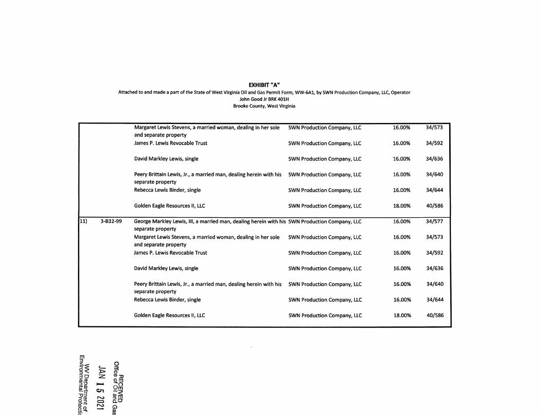
9) 3-B32-116 George Markley Lewis, III, a married man SWN Production Company, LLC
Margaret Lewis Stevens, a married woman, dealing in her sole SWN Production Company, LLC
and separate property
James P. Lewis Revocable Trust SWN Production Company, LLC
David Markley Lewis, single
Peery Brittain Lewis, Jr., a married man
Rebecca Lewis Binder, single
Golden Eagle Resources II, LLC
SWN Production Company, LLC
SWN Production Company, LLC
SWN Production Company, LLC
SWN Production Company, LLC
16.00%
16.00%
16.00%
16.00%
16.00%
16.00%
18.00%
34/577
34/573
34/592
34/636
34/640
34/644
40/586
10) 3-B32-99.1 George Markley Lewis, III, a married man, dealing herein with his SWN Production Company, LLC
separate property
16.00% 34/577
m3< _
oo
o3
o >3 ̂
(D fD
O 3 C3 ClOro
9.!!!oQm
Q&)Oi
EXHIBIT "A"
Attached to and made a part of the State of West Virginia Oil and Gas Permit Form, WW-6A1, by SWN Production Company, LLC, Operator
John GoodJrBRK401H
Brooke County, West Virginia
Margaret Lewis Stevens, a married woman, dealing in her sole SWN Production Company, LLC 16.00% 34/573
and separate property
James P. Lewis Revocable Trust SWN Production Company, LLC 16.00% 34/592
David Markley Lewis, single SWN Production Company, LLC 16.00% 34/636
Peery Brittain Lewis, Jr., a married man, dealing herein with his SWN Production Company, LLC 16.00% 34/640
separate property
Rebecca Lewis Binder, single SWN Production Company, LLC 16.00% 34/644
Golden Eagle Resources II, LLC SWN Production Company, LLC 18.00% 40/586
11) 3-B32-99 George Markley Lewis, III, a married man, dealing herein with his SWN Production Company, LLC 16.00% 34/577
separate property
Margaret Lewis Stevens, a married woman, dealing in her sole SWN Production Company, LLC 16.00% 34/573
and separate property
James P. Lewis Revocable Trust SWN Production Company, LLC 16.00% 34/592
David Markley Lewis, single SWN Production Company, LLC 16.00% 34/636
Peery Brittain Lewis, Jr., a married man, dealing herein with his SWN Production Company, LLC 16.00% 34/640
separate property
Rebecca Lewis Binder, single SWN Production Company, LLC 16.00% 34/644
Golden Eagle Resources II, LLC SWN Production Company, LLC 18.00% 40/586
m13
o Srj ̂
CD ®
cn
o
Z ® 3JS.i3
Jq 5 LjOn CD Q.C/
o
EXHIBIT "A"
Attached to and made a part of the State of West Virginia Oil and Gas Permit Form, WW-6A1, by SWN Production Company, LLC, Operator
John Good Jr BRK 401H
Brooke County, West Virginia
12) 3-B32-100 George Markley Lewis, III, a married man, dealing herein with his SWN Production Company, LLC
separate property
Margaret Lewis Stevens, a married woman, dealing in her sole SWN Production Company, LLC
and separate property
James P. Lewis Revocable Trust SWN Production Company, LLC
16.00%
16.00%
16.00%
34/577
34/573
34/592
David Markley Lewis, single SWN Production Company, LLC 16.00% 34/636
Peery Brittain Lewis, Jr., a married man, dealing herein with his
separate property
Rebecca Lewis Binder, single
SWN Production Company, LLC
SWN Production Company, LLC
16.00%
16.00%
34/640
34/644
Golden Eagle Resources II, LLC SWN Production Company, LLC 18.00% 40/586
13) Pierce Run Road West Virginia Department of Transportation, Division of
Highways
Chesapeake Appalachia, L.L.C.
SWN Production Company, LLC
15.00% 18/723
30/480
14) 3-B32-96 Samuel H. Hubbard and Shelba Hubbard, husband and wife Chesapeake Appalachia, L.L.C.
SWN Production Company, LLC
18.00% 11/720
30/480
15) 3-B32-90 Leo F. Bolden and Barbara R. Bolden, husband and wife Chesapeake Appalachia, L.L.C.
SWN Production Company, LLC
18.00% 13/213
30/480
16) 3-B32-89 Kasler Oil & Gas Development LLC., an Ohio Limited Liability
company
Young Brothers L.L.C., an Oregon Limited liability company
SWN Production Company, LLC
SWN Production Company, LLC
15.00%
15.00%
33/696
33/691
17) 3-B32-88 Kasler Oil & Gas Development L.L.C., an Ohio Limited Liability
company
SWN Production Company, LLC 15.00% 33/696
v/
mD
O S
I—A
915-d3-Tfo
o3
o
j> oCO 30o m
Om
ro rs L,o 3 C3 Q.^
ro^ Q
EXHIBIT "A"
Attached to and made a part of the State of West Virginia Oil and Gas Permit Form, WW-6A1, by SWN Production Company, LLC, Operator
John Good JrBRK401H
Brooke County, West Virginia /
Young Brothers L.L.C., an Oregon Limited liability company SWN Production Company, LLC 15.00% 33/691
18) 3-B32G-11 Wilma Sue Yano and Robert J. Yano, wife and husband Chesapeake Appalachia, L.L.C.
SWN Production Company, LLC
18.00% 23/748
30/480
19) 3-B32G-10 James E. Best and Annette M. Best, husband and wife SWN Production Company, LLC 18.00% 56/248
20) 3-B32G-9 James E. Best and Annette M. Best, husband and wife SWN Production Company, LLC 18.00% 56/248
21) 3-B32G-8 John H. Fox, a single man Chesapeake Appalachia, L.L.C.
SWN Production Company, LLC
18.00% 24/542
30/480
22) 3-B326-7 Robert F. Ohier, a widower Chesapeake Appalachia, L.L.C.
SWN Production Company, LLC
18.00% 24/85
30/480
23) 3-B32-9 Schiappa and Company, Inc. SWN Production Company, LLC 15.50% 33/356
24) 3-B32G-67 Bounty Minerals LLC, a Texas Limited Liability Company SWN Production Company, LLC 18.00% 41/38
25) 3-B326-67.1 Bounty Minerals LLC, a Texas Limited Liability Company SWN Production Company, LLC 18.00% 41/38
Schiappa and Company, Inc. SWN Production Company, LLC 18.00% 39/605
26) 3-B32-64 Steve D. Martino and Mary Christine Martino, husband and wife Chesapeake Appalachia, L.L.C.
SWN Production Company, LLC
18.00% 22/302
30/480
27) 3-B32-51 Marlin G. Crawford, divorced and unremarried, and Judith A.
Crawford, divorced and unremarried
Chesapeake Appalachia, L.L.C.
SWN Production Company, LLC
16.00% 22/398
30/480
28) 3-B32-50 Marlin G. Crawford, divorced and unremarried, and Judith A.
Crawford, divorced and unremarried
Chesapeake Appalachia, L.L.C.
SWN Production Company, LLC
16.00% 22/398
30/480
m3
§5 >go za>^
I—i
ro"d3
CD
9.3
o3
O
oOjuo m
Qm
Q.O
o
EXHIBIT "A"
Attached to and made a part of the State of West Virginia Oil and Gas Permit Form, WW-6A1, by SWN Production Company, LLC, Operator
John GoodJrBRK401H
Brooke County, West Virginia
29) 3-B32-44 Cecil H. Toner and Pamela A. Toner, husband and wife Chesapeake Appalachia, L.L.C.
SWN Production Company, LLC
18.00% 26/54
30/480
30) 3-B32-43 Debra K Rockey, divorced and unremarried Chesapeake Appalachia, L.LC.
SWN Production Company, LLC
18.00% 25/612
30/480
31) 3-B32-40 Frank A. Yano and Katherine Yano, husband and wife, (Life
Tenants), and Kurt Michael Yano, single, (remainderman)Chesapeake Appalachia, L.L.C.
SWN Production Company, LLC
18.00% 26/464
30/480
32) 3-B32-39 Ronald W. Jordan and Hope L Jordan, husband and wife Chesapeake Appalachia, L.L.C.
SWN Production Company, LLC
18.00% 25/607
30/480
33) 3-B32-38 James Edward Stillwell and Katherine 1. Stillwell, husband and
wife
Chesapeake Appalachia, L.L.C.
SWN Production Company, LLC
18.00% 26/342
30/480
34) 3-B32-37 John Ferda and Betty Ferda, a/k/a Betty L. Ferda, husband and
wife
Chesapeake Appalachia, L.L.C.
SWN Production Company, LLC
18.00% 26/372
30/480
35) 3-B32-36 John Ferda and Betty Ferda, a/k/a Betty L. Ferda, husband and
wife
Chesapeake Appalachia, L.LC.
SWN Production Company, LLC
18.00% 26/372
30/480
36) 3-B32-1 Gregory S. Deditch, a married man, dealing herein with his
separate property
SWN Production Company, LLC 18.00% 37/718
37) 3-B27P-30 Gertrude Louise McShane Robie, a married woman dealingherein with her separate property, and Richard Robert Robie,
her husband
SWN Production Company, LLC 18.00% 33/605
38) 3-B27R-50 William Kisner, a single man SWN Production Company, LLC 18.00% 42/452
39) 3-B27P-22 Sandra Hall Hartner, married, dealing herein with her separate
property
Kim Smith Vinson, married, dealing herein with her separate
property
SWN Production Company, LLC
SWN Production Company, LLC
18.00%
18.00%
45/549
46/756
mD
as.O'3
oo >3 ̂
3?CD ®
ei-i en
9.3 CD C3.C7INJ
CD 3,
9,!2?
ofi}
EXHIBIT "A"
Attached to and made a part of the State of West Virginia Oil and Gas Permit Form, WW-6A1, by SWN Production Company, LLC, Operator
John Good Jr BRK 401H
Brooke County, West Virginia
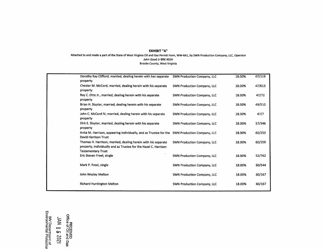
Thomas A. McCord II, married, dealing in his separate property SWN Production Company, LLC 18.00% 46/750
Dorothy Kay Clifford, married, dealing herein with her separate SWN Production Company, LLC 18.00% 47/119
property
Chester M. McCord, married, dealing herein with his separate SWN Production Company, LLC 18.00% 47/613
property
Ray C. Otte Jr., married, dealing herein with his separate SWN Production Company, LLC 18.00% 47/72
property
Brian H. Sluyter, married, dealing herein with his separate SWN Production Company, LLC 18.00% 49/510
property
John C. McCord IV, married, dealing herein with his separate SWN Production Company, LLC 18.00% 47/7
property
Dirk E. Sluyter, married, dealing herein with his separate SWN Production Company, LLC 18.00% 57/346
property
Anita M. Harrison, appearing individually, and as Trustee for the SWN Production Company, LLC 18.00% 60/253
David Harrison Trust
Thomas H. Harrison, married, dealing herein with his separate SWN Production Company, LLC 18.00% 60/259
property. Individually and as Trustee for the Hazel C. Harrison
Testamentary Trust
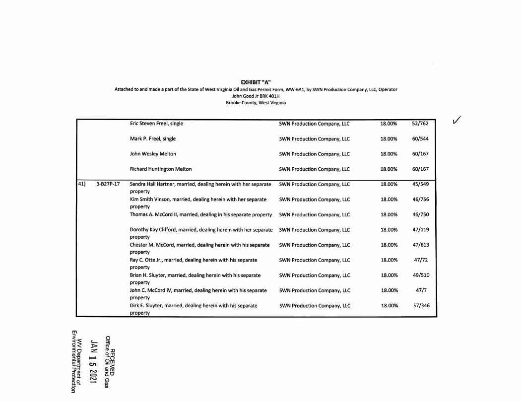
Eric Steven Freel, single SWN Production Company, LLC 18.00% 52/762
Mark P. Freel, single SWN Production Company, LLC 18.00% 60/544
John Wesley Melton SWN Production Company, LLC 18.00% 60/167
m3
§< >
CD 4$
"d3 ^rj 2 rs:> 32.3
ooro
O3o03,o mn
Qm
Q.O
Q
$
EXHIBIT "A"
Attached to and made a part of the State of West Virginia Oil and Gas Permit Form, WW-6A1, by SWN Production Company, LLC, Operator
John Good Jr BRK 401H
Brooke County, West Virginia
Richard Huntington Melton SWN Production Company, LLC 18.00% 60/167
40) 3-B27P-18 Sandra Hall Hartner, married, dealing herein with her separate SWN Production Company, LLC 18.00% 45/549
property
Kim Smith Vinson, married, dealing herein with her separate SWN Production Company, LLC 18.00% 46/756
property
Thomas A. McCord II, married, dealing In his separate property SWN Production Company, LLC 18.00% 46/750
Dorothy Kay Clifford, married, dealing herein with her separate SWN Production Company, LLC 18.00% 47/119
property
Chester M. McCord, married, dealing herein with his separate SWN Production Company, LLC 18.00% 47/613
property
Ray C. Otte Jr., married, dealing herein with his separate SWN Production Company, LLC 18.00% 47/72
property
Brian H. Sluyter, married, dealing herein with his separate SWN Production Company, LLC 18.00% 49/510
property
John C. McCord IV, married, dealing herein with his separate SWN Production Company, LLC 18.00% 47/7
property
Dirk E. Sluyter, married, dealing herein with his separate SWN Production Company, LLC 18.00% 57/346
property
Anita M. Harrison, appearing individually, and as Trustee for the SWN Production Company, LLC 18.00% 60/253
David Harrison Trust
Thomas H. Harrison, married, dealing herein with his separate SWN Production Company, LLC 18.00% 60/259
property. Individually and as Trustee for the Hazel C. Harrison
Testamentary Trust
m3
O ̂3 ̂
(d42
w
^ ® 31o m
^ nQ"d3 Q)3 (D ro 3 rnO3 CD clO
oo
o3
roQfi)CO
EXHIBIT "A"
Attached to and made a part of the State of West Virginia Oil and Gas Permit Form, WW-6A1, by SWN Production Company, LLC, Operator
John GoodJr BRK401H
Brooke County, West Virginia
Eric Steven Free!, single SWN Production Company, LLC 18.00% 52/762
Mark P. Free!, single SWN Production Company, LLC 18.00% 60/544
John Wesley Melton SWN Production Company, LLC 18.00% 60/167
Richard Huntlngton Melton SWN Production Company, LLC 18.00% 60/167
41) 3-B27P-17 Sandra Hall Hartner, married, dealing herein with her separate SWN Production Company, LLC 18.00% 45/549
property
Kim Smith Vinson, married, dealing herein with her separate SWN Production Company, LLC 18.00% 46/756
property
Thomas A. McCord II, married, dealing In his separate property SWN Production Company, LLC 18.00% 46/750
Dorothy Kay Clifford, married, dealing herein with her separate SWN Production Company, LLC 18.00% 47/119
property
Chester M. McCord, married, dealing herein with his separate SWN Production Company, LLC 18.00% 47/613
property
Ray C. Otte Jr., married, dealing herein with his separate SWN Production Company, LLC 18.00% 47/72
property
Brian H. Sluyter, married, dealing herein with his separate SWN Production Company, LLC 18.00% 49/510
property
John C. McCord IV, married, dealing herein with his separate SWN Production Company, LLC 18.00% 47/7
property
Dirk E. Sluyter, married, dealing herein with his separate SWN Production Company, LLC 18.00% 57/346
property
i/
m
I?§ <300)42
OD
o3
J> o— ®
Qm
o 3 c=> clOro O
0)(0
EXHIBIT "A"
Attached to and made a part of the State of West Virginia Oil and Gas Permit Form, WW-6A1, by SWN Production Company, LLC, Operator
John GoodJrBRK401H
Brooke County, West Virginia
Anita M. Harrison, appearing individually, and as Trustee for the SWN Production Company, LLC 18.00% 60/253
David Harrison Trust
Thomas H. Harrison, married, dealing herein with his separate SWN Production Company, LLC 18.00% 60/259
property. Individually and as Trustee for the Hazel C. Harrison
Testamentary Trust
Eric Steven Freel, single SWN Production Company, LLC 18.00% 52/762
Mark P. Freel, single SWN Production Company, LLC 18.00% 60/544
John Wesley Melton SWN Production Company, LLC 18.00% 60/167
Richard Huntington Melton SWN Production Company, LLC 18.00% 60/167
42) 3-B27P-10 Martha K. Williams, a single woman SWN Production Company, LLC 16.00% 42/600
43) 3-B27P-9 Martha K. Williams, a single woman SWN Production Company, LLC 16.00% 42/600
44) 3-B27P-31 William Kisner, a single man SWN Production Company, LLC 18.00% 42/452
45) 3-B27P-7 Sandra Hall Hartner, married, dealing herein with her separate SWN Production Company, LLC 18.00% 45/549
property
Kim Smith Vinson, married, dealing herein with her separate SWN Production Company, LLC 18.00% 46/756
property
Thomas A. McCord II, married, dealing in his separate property SWN Production Company, LLC 18.00% 46/750
J
m
o
gl > fCD
30CD 45
So.o3
3,
9.13?Qm
0 r«0 3 •IjO 3 c=> Q-O
G)D)0)
EXHIBIT "A"
Attached to and made a part of the State of West Virginia Oil and Gas Permit Form, WW-6A1, by SWN Production Company, LLC, Operator
John GoodJrBRK401H
Brooke County, West Virginia
Dorothy Kay Clifford, married, dealing herein with her separate SWN Production Company,LLC 18.00% 47/119
property
Chester M. McCord, married, dealing herein with his separate SWN Production Company,LLC 18.00% 47/613
property
Ray C. Otte Jr., married, dealing herein with his separate SWN Production Company,LLC 18.00% 47/72
property
Brian H. Sluyter, married, dealing herein with his separate SWN Production Company,LLC 18.00% 49/510
property
John C. McCord IV, married, dealing herein with his separate SWN Production Company,LLC 18.00% 47/7
property
Dirk E. Sluyter, married, dealing herein with his separate SWN Production Company,LLC 18.00% 57/346
property
Anita M. Harrison, appearing individually, and as Trustee for the SWN Production Company,LLC 18.00% 60/253
David Harrison Trust
Thomas H. Harrison, married, dealing herein with his separate SWN Production Company,LLC 18.00% 60/259
property. Individually and as Trustee for the Hazel C. Harrison
Testamentary Trust
Eric Steven Free!, single SWN Production Company,LLC 18.00% 52/762
Mark P. Freel, single SWN Production Company,LLC 18.00% 60/544
John Wesley Melton SWN Production Company,LLC 18.00% 60/167
Richard Huntington Melton SWN Production Company,LLC 18.00% 60/167
m
i..O 5
(D® . .
Si.a en■03
^ §CDu,asQeu
s§ ^§.9. £::i Q
EXHIBIT "A"
Attached to and made a part of the State of West Virginia Oil and Gas Permit Form, WW-6A1, by SWN Production Company, LLC, Operator
John GoodJr BRK401H
Brooke County, West Virginia
46) 3-B27P-5 Sandra Hall Hartner, married, dealing herein with her separate SWN Production Company, LLC 18.00% 45/549
property
Kim Smith Vinson, married, dealing herein with her separate SWN Production Company, LLC 18.00% 46/756
property
Thomas A. McCord II, married, dealing in his separate property SWN Production Company, LLC 18.00% 46/750
Dorothy Kay Clifford, married, dealing herein with her separate SWN Production Company, LLC 18.00% 47/119
property
Chester M. McCord, married, dealing herein with his separate SWN Production Company, LLC 18.00% 47/613
property
Ray C. Otte Jr., married, dealing herein with his separate SWN Production Company, LLC 18.00% 47/72
property
Brian H. Sluyter, married, dealing herein with his separate SWN Production Company, LLC 18.00% 49/510
property
John C. McCord IV, married, dealing herein with his separate SWN Production Company, LLC 18.00% 47/7
property
Dirk E. Sluyter, married, dealing herein with his separate SWN Production Company, LLC 18.00% 57/346
property
Anita M. Harrison, appearing individually, and as Trustee for the SWN Production Company, LLC 18.00% 60/253
David Harrison Trust
Thomas H. Harrison, married, dealing herein with his separate SWN Production Company, LLC 18.00% 60/259
property. Individually and as Trustee for the Hazel C. Harrison
Testamentary Trust
Eric Steven Freel, single SWN Production Company, LLC 18.00% 52/762
< _
i'lp p
og
rs:>CDrv>
O3?o
cn Sm
E.O0C]01
EXHIBIT "A"
Attached to and made a part of the State of West Virginia Oil and Gas Permit Form, WW-6A1, by SWN Production Company, LLC, Operator
John Good Jr BRK 401H
Brooke County, West Virginia
Mark P. Freel, single SWN Production Company, LLC 18.00% 60/544
John Wesley Melton SWN Production Company, LLC 18.00% 60/167
Richard Huntington Melton SWN Production Company, LLC 18.00% 60/167
47) 3-B27K-188 Sandra Hall Hartner, married, dealing herein with her separate SWN Production Company, LLC 18.00% 45/549
property
Kim Smith VInson, married, dealing herein with her separate SWN Production Company, LLC 18.00% 46/756
property
Thomas A. McCord II, married, dealing In his separate property SWN Production Company, LLC 18.00% 46/750
Dorothy Kay Clifford, married, dealing herein with her separate SWN Production Company, LLC 18.00% 47/119
property
Chester M. McCord, married, dealing herein with his separate SWN Production Company, LLC 18.00% 47/613
property
Ray C. Otte Jr., married, dealing herein with his separate SWN Production Company, LLC 18.00% 47/72
property
Brian H. Sluyter, married, dealing herein with his separate SWN Production Company, LLC 18.00% 49/510
property
John C. McCord IV, married, dealing herein with his separate SWN Production Company, LLC 18.00% 47/7
property
Dirk E. Sluyter, married, dealing herein with his separate SWN Production Company, LLC 18.00% 57/346
property
Anita M. Harrison, appearing individually, and as Trustee for the SWN Production Company, LLC 18.00% 60/253
David Harrison Trust
!*n-3
o ;>
^ o 2:
0)
"05
oa0*3
o
fc: ̂J> oCD jjo m
Qrri
-Vro ro 3 fD03 c=> Q-C/
Q0)0)
EXHIBIT "A"
Attached to and made a part of the State of West Virginia Oil and Gas Permit Form, WW-6A1, by SWN Production Company, LLC, Operator
John GoodJrBRK401H
Brooke County, West Virginia
Thomas H. Harrison, married, dealing herein with his separate
property. Individually and as Trustee for the Hazel C. Harrison
Testamentary Trust
Eric Steven Freel, single
SWN Production Company, LLC
SWN Production Company, LLC
18.00%
18.00%
60/259
52/762
Mark P. Freel, single SWN Production Company, LLC 18.00% 60/544
John Wesley Melton SWN Production Company, LLC 18.00% 60/167
Richard Huntington Melton SWN Production Company, LLC 18.00% 60/167
48) 3-B27K-159 Beverly K. Fuchs, a widow SWN Production Company, LLC 18.00% 39/774
49) Buffalo Creek State of West Virginia, Department of Commerce, Division of
Natural Resources
SWN Production Company, LLC 15.00% 55/479
50) 3-B27K-160 The Wellsburg First Church of God SWN Production Company, LLC 18.00% 43/160
51) 3-B27K-153 William L. Hukill, married, dealing In his separate property SWN Production Company, LLC 18.00% 55/362
Robin L. Snyder, married, dealing in her separate property SWN Production Company, LLC 18.00% 56/25
Stacey Hukill Wise, divorced SWN Production Company, LLC 18.00% 55/349
52) 3-B27K-91 Thomas Hukill and Mauna Kay Hukill, husband and wife Chesapeake Appaiachia, L.L.C.
SWN Production Company, LLC
18.00% 24/730
30/480
m
< _
11IfDp
uS ^ A) SCD 3 m
2.3. CD dO
ia go" CO
EXHIBIT "A"
Attached to and made a part of the State of West Virginia Oil and Gas Permit Form, WW-6A1, by SWN Production Company, LLC, Operator
John GoodJrBRK401H
Brooke County, West Virginia /53) 3-B27K-92 Shelby Carre!!, married, dealing in her separate property SWN Production Company, LLC 18.00% 56/621
Bonnie L. Lukacena, a widow SWN Production Company, LLC 18.00% 56/607
Julie Shey Miller, aka J. Shey Schuetzner, married, dealing in her
separate property
Shayne Schuetzner, single
SWN Production Company, LLC
SWN Production Company, LLC
18.00%
18.00%
56/635
56/628
Shanon Schuetzner, married, dealing in his separate property SWN Production Company, LLC 18.00% 56/614
54) 3-B27K-93 Shelby Carrell, married, dealing in her separate property SWN Production Company, LLC 18.00% 56/621
Bonnie L. Lukacena, a widow SWN Production Company, LLC 18.00% 56/607
Julie Shey Miller, aka J. Shey Schuetzner, married, dealing in her
separate property
Shayne Schuetzner, single
SWN Production Company, LLC
SWN Production Company, LLC
18.00%
18.00%
56/635
56/628
Shanon Schuetzner, married, dealing in his separate property SWN Production Company, LLC 18.00% 56/614
55) 3-B27K-73 Robin Johnson, f/k/a Robin Funderburk, married, dealing in her
separate property
SWN Production Company, LLC 18.00% 55/543
56) 3-B27K-72 Shanon Schuetzner, a married man dealing in his sole and
separate property
Bonnie Lee Lukacena and John N. Lukacena, wife and husband
Chesapeake Appalachia, L.LC.
SWN Production Company, LLC
Chesapeake Appalachia, LL.C.
SWN Production Company, LLC
18.00%
18.00%
24/443
30/480
24/450
30/480
m
<
5 S
§■§^ D)
■o3
o m-"(Sogpf Q § n jSoo3
o(UCO
EXHIBIT "A"
Attached to and made a part of the State of West Virginia Oil and Gas Permit Form, WW-6A1, by SWN Production Company, LLC, Operator
John GoodJrBRK401H
Brooke County, West Virginia JShey Schuetzner, a married woman dealing In her sole and Chesapeake Appalachia, L.L.C. 18.00% 25/177
separate property SWN Production Company, LLC 30/480
Shayne Schuetzner, a single man Chesapeake Appalachia, L.L.C. 18.00% 25/185
SWN Production Company, LLC 30/480
Shelby Carrell, a married woman dealing In her sole and separate Chesapeake Appalachia, L.L.C. 18.00% 26/566
property SWN Production Company, LLC 30/480
57) 3-B27K-47 Shelby Carrell, married, dealing In her separate property SWN Production Company, LLC 18.00% 56/621
Bonnie L. Lukacena, a widow SWN Production Company, LLC 18.00% 56/607
Julie Shey Miller, aka J. Shey Schuetzner, married, dealing in her SWN Production Company, LLC 18.00% 56/635
separate property
Shayne Schuetzner, single SWN Production Company, LLC 18.00% 56/628
Shanon Schuetzner, married, dealing in his separate property SWN Production Company, LLC 18.00% 56/614
58) 3-B27K-48 Shelby Carrell, married, dealing in her separate property SWN Production Company, LLC 18.00% 56/621
Bonnie L. Lukacena, a widow SWN Production Company, LLC 18.00% 56/607
Julie Shey Miller, aka J. Shey Schuetzner, married, dealing in her SWN Production Company, LLC 18.00% 56/635
separate property
Shayne Schuetzner, single SWN Production Company, LLC 18.00% 56/628
Shanon Schuetzner, married, dealing in his separate property SWN Production Company, LLC 18.00% 56/614
m
if ^3D z:(D ̂
-d33g
or«
rocz>
roSo
o<D J,
Qq]
§ ̂Q-O
QP)0)
EXHIBIT "A"
Attached to and made a part of the State of West Virginia Oil and Gas Permit Form, WW-6A1, by SWN Production Company, LLC, Operator
John Good Jr BRK 401H
Brooke County, West Virginia
59) 3-B27K-22 Shelby Carrell, married, dealing in her separate property SWN Production Company, LLC 18.00% 56/621
Bonnie L. Lukacena, a widow SWN Production Company, LLC 18.00% 56/607
Julie Shey Miller, aka J. Shey Schuetzner, married, dealing in her
separate property
Shayne Schuetzner, single
SWN Production Company, LLC
SWN Production Company, LLC
18.00%
18.00%
56/635
56/628
Shanon Schuetzner, married, dealing in his separate property SWN Production Company, LLC 18.00% 56/614
60) 3-B27K-6.1 Shelby Carrell, married, dealing in her separate property SWN Production Company, LLC 18.00% 56/621
Bonnie L. Lukacena, a widow SWN Production Company, LLC 18.00% 56/607
Julie Shey Miller, aka J. Shey Schuetzner, married, dealing in her
separate property
Shayne Schuetzner, single
SWN Production Company, LLC
SWN Production Company, LLC
18.00%
18.00%
56/635
56/628
Shanon Schuetzner, married, dealing in his separate property SWN Production Company, LLC 18.00% 56/614
61) 3-B27K-6 Shelby Carrell, married, dealing In her separate property SWN Production Company, LLC 18.00% 56/621
Bonnie L. Lukacena, a widow SWN Production Company, LLC 18.00% 56/607
Julie Shey Miller, aka J. Shey Schuetzner, married, dealing in her
separate property
SWN Production Company, LLC 18.00% 56/635
m
o 5go ^
cn
oad"o'3
o
y> o0 JJQ m
Qm
3 3 c=> clOCDw
EXHIBIT "A"
Attached to and made a part of the State of West Virginia Oil and Gas Permit Form, WW-6A1, by SWN Production Company, LLC, Operator
John GoodJrBRK401H
Brooke County, West Virginia /
Shayne Schuetzner, single SWN Production Company, LLC 18.00% 56/628
Shanon Schuetzner, married, dealing in his separate property SWN Production Company, LLC 18.00% 56/614
62) 3-B27K-9 Shelby Carrell, married, dealing in her separate property SWN Production Company, LLC 18.00% 56/621
Bonnie L. Lukacena, a widow SWN Production Company, LLC 18.00% 56/607
Julie Shey Miller, aka J. Shey Schuetzner, married, dealing in her SWN Production Company, LLC 18.00% 56/635
separate property
Shayne Schuetzner, single SWN Production Company, LLC 18.00% 56/628
Shanon Schuetzner, married, dealing in his separate property SWN Production Company, LLC 18.00% 56/614
63) 3-B27K-8 Shelby Carrell, married, dealing in her separate property SWN Production Company, LLC 18.00% 56/621
Bonnie L. Lukacena, a widow SWN Production Company, LLC 18.00% 56/607
Julie Shey Miller, aka J. Shey Schuetzner, married, dealing in her SWN Production Company, LLC 18.00% 56/635
separate property
Shayne Schuetzner, single SWN Production Company, LLC 18.00% 56/628
Shanon Schuetzner, married, dealing in his separate property SWN Production Company, LLC 18.00% 56/614
64) 3-B27K-7 Shelby Carrell, married, dealing in her separate property SWN Production Company, LLC 18.00% 56/621
m3< ̂ o
3> oo >3 ̂
(1)45. KaoA
;:5 CD w r io 3 <Z3 OL^
oQ —
(D
S,m
Qm
Q030)
EXHIBIT "A"
Attached to and made a part of the State of West Virginia Oil and Gas Permit Form, WW-6A1, by SWN Production Company, LLC, Operator
John GoodJr BRK401H
Brooke County, West Virginia
Bonnie L. Lukacena, a widow SWN Production Company, LLC 18.00% 56/607
Julie Shey Miller, aka J. Shey Schuetzner, married, dealing in her SWN Production Company, LLC 18.00% 56/635
separate property
Shayne Schuetzner, single SWN Production Company, LLC 18.00% 56/628
Shanon Schuetzner, married, dealing in his separate property SWN Production Company, LLC 18.00% 56/614
65) 3-B27K-11 Shelby Carrell, married, dealing in her separate property SWN Production Company, LLC 18.00% 56/621
Bonnie L. Lukacena, a widow SWN Production Company, LLC 18.00% 56/607
Julie Shey Miller, aka J. Shey Schuetzner, married, dealing in her SWN Production Company, LLC 18.00% 56/635
separate property
Shayne Schuetzner, single SWN Production Company, LLC 18.00% 56/628
Shanon Schuetzner, married, dealing in his separate property SWN Production Company, LLC 18.00% 56/614
66) 3-B27K-12 Shelby Carrell, married, dealing in her separate property SWN Production Company, LLC 18.00% 56/621
Bonnie L. Lukacena, a widow SWN Production Company, LLC 18.00% 56/607
Julie Shey Miller, aka J. Shey Schuetzner, married, dealing in her SWN Production Company, LLC 18.00% 56/635
separate property
Shayne Schuetzner, single SWN Production Company, LLC 18.00% 56/628
EXHIBIT "A"
Attached to and made a part of the State of West Virginia Oil and Gas Permit Form, WW-6A1, by SWN Production Company, LLC, Operator
John Good Jr BRK 401H
Brooke County, West Virginia y
Shanon Schuetzner, married, dealing in his separate property SWN Production Company, LLC 18.00% 56/614
67) 3-B27F-2 AMP Fund III, LP SWN Production Company, LLC 16.00% 56/284
68) 7-W27F-233 Shelby Carrell, married, dealing in her separate property SWN Production Company, LLC 18.00% 56/621
Bonnie L. Lukacena, a widow SWN Production Company, LLC 18.00% 56/607
Julie Shey Miller, aka J. Shey Schuetzner, married, dealing in her
separate property
Shayne Schuetzner, single
SWN Production Company, LLC
SWN Production Company, LLC
18.00%
18.00%
56/635
56/628
Shanon Schuetzner, married, dealing in his separate property SWN Production Company, LLC 18.00% 56/614
69) 7-W27F-234 Shelby Carrell, married, dealing in her separate property SWN Production Company, LLC 18.00% 56/621
Bonnie L. Lukacena, a widow SWN Production Company, LLC 18.00% 56/607
Julie Shey Miller, aka J. Shey Schuetzner, married, dealing in her
separate property
Shayne Schuetzner, single
SWN Production Company, LLC
SWN Production Company, LLC
18.00%
18.00%
56/635
56/628
Shanon Schuetzner, married, dealing in his separate property SWN Production Company, LLC 18.00% 56/614
70) 7-W27F-227 Sue A. Griffith, single SWN Production Company, LLC 18.00% 57/334
m3
1"^ «- =fO
go Z-34? H-^75. Ol
C 3
gos
jjQ m
Om
ro 3
o0)
EXHIBIT "A"
Attached to and made a part of the State of West Virginia Oil and Gas Permit Form, WW-6A1, by SWN Production Company, LLC, Operator
John Good Jr BRK 401H
Brooke County, West Virginia
71) 7-W27F-223 Steven A. Buck, married, dealing in his separate property SWN Production Company, LLC 18.00% 56/694
72) 7-W27F-192 Amy M. Ewusiak, single SWN Production Company, LLC 18.00% 57/562
Joseph Paul Pettini, married, dealing in his separate property SWN Production Company, LLC 18.00% 57/568
73 7-W27F-193 Ris6 L. Katnik, single SWN Production Company, LLC 18.00% 57/658
74) 7-W27F-194 Rise' L. Katnik, single SWN Production Company, LLC 18.00% 57/658
75) 7-W27F-164 Alfred T. Marino, single SWN Production Company, LLC 17.00% 58/484
76) 7-W27F-161 Alfred T. Marino, single SWN Production Company, LLC 17.00% 58/484
77) 7-W27F-160 Daniel L. Johnston, a/k/a Danny Johnston, married, dealing in his SWN Production Company, LLC
separate property
18.00% 59/90
78) 7-W27F-1S4 Business Development Corporation of the Northern Panhandle,
Inc.
SWN Production Company, LLC 18.00% 59/352
mD< -
O >3 ̂
3^
-o3
oo
Ol
0 3)o m
Qm
§ ̂a.O
aP)in
A ^ SWN Production Company, LLC% /\ / I I 179 Innovation Drive
V J V w I I Jane Lew, WV 26378Production Company'" p®'' p™
^ ̂ Fax: 304 471 2497
www.swn.com
January 7, 2021
Ms. Laura Adkins
WV DEP Office of Oil & Gas
601 57"^ St., SBCharleston, WV 25304
RE: SWN's proposed New Well: John Good Jr. BRK 401H in Brooke County, West Virginia, Drillingunder Brady's Ridge Road, Pierce Run Road, Bethany Pike, McAdoo Ridge Road, Route 67/1, Irish Est,Green Acres, Green Run Road, Walnut St, Lower Commerce St Exd, Buffalo Road, Susquehanna Road,Navajo Road, SR 2, and 5"^ Street.
Dear Ms. Adkins:
SWN Production Company, LLC ("SWN") is applying for a drilling permit for the above referencedwell. The State of West Virginia has raised some concern as to SWN's right to drill under Brady'sRidge Road, Pierce Run Road, Bethany Pike, McAdoo Ridge Road, Route 67/1, Irish Est, Green Acres,Green Run Road, Walnut St, Lower Commerce St Exd., Buffalo Road, Susquehanna Road, NavajoRoad, SR 2, and 5"^ Street. Please be advised that SWN has leased all mineral owners under said route asit relates to the above-referenced well and unit.
Thank you.
Sincerely,
John D. Startz, CPE
Technical Expert LandmanSWN Production Company, LLCPO Box 12359
Spring, TX 77391-2359
RECEIVED ̂Office of Oil and uas
JAN 1 5 2021
VW Department of.nnmental Protection
TTie Right People doing the Right Things,wisely Investing the cash flow from CHjrunderlying Assets, will create Value+®
WW-6AC
(1/12) 470 0 9 0 0 3 87
STATE OF WEST VIRGINIA
DEPARTMENT OF ENVIRONMENTAL PROTECTION, OFFICE OF OIL AND GASNOTICE CERTIFICATION
,\H API NoDate of Notice Certification: . 47- 009
Operator's Well No. o°hn GoodJr.BRK40iHWeil Pad Name: John Good jr. BRK
Notice has been given:Pursuant to the provisions in West Virginia Code § 22-6A, the Operator has provided the required parties with the Notice Forms listedbelow for the tract of land as follows:
Easting: 535695.54Northing:
Public Road Access:
Generally used farm name:
State:
County:
District:
Quadrangle:
West Virginia
009- BrookeUTM NAD 83
4452679.11
Buffalo
Bethany & Steubenviiie East
McAdoo Ridge Road
John Good Jr.
Watershed: Upper Ohio South
Pursuant to West Virginia Code § 22-6A-7(b), every permit application filed under this section shall be on a form as may beprescribed by the secretary, shall be verified and shall contain the following information: (14) A certification from the operator that (i)it has provided the owners of the surface described in subdivisions (1), (2) and (4), subsection (b), section ten of this article, theinformation required by subsections (b) and (c), section sixteen of this article; (ii) that the requirement was deemed satisfied as a resultof giving the surface owner notice of entry to survey pursuant to subsection (a), section ten of this article six-a; or (iii) the noticerequirements of subsection (b), section sixteen of this article were waived in writing by the surface owner; and Pursuant to WestVirginia Code § 22-6A-1 1 (b), the applicant shall tender proof of and certify to the secretary that the notice requirements of section tenof this article have been completed by the applicant.
Pursuant to West Virginia Code § 22-6A, the Operator has attached proof to this Notice Certificationthat the Operator has properly served the required parties with the following:
♦PLEASE CHECK ALL THAT APPLY
□ 1. NOTICE OF SEISMIC ACTIVITY or S NOTICE NOT REQUIRED BECAUSE NOSEISMIC ACTIVITY WAS CONDUCTED
B 2. NOTICE OF ENTRY FOR PLAT SURVEY or □ NO PLAT SURVEY WAS CONDUCTED
B 3. NOTICE OF INTENT TO DRILL or □ NOTICE NOT REQUIRED BECAUSENQTICE QF ENTRY FQR PLAT SURVEYWAS CQNDUCTED or
□ WRITTEN WAIVER BY SURFACE OWNER(PLEASE ATTACH)
B 4. NOTICE OF PLANNED OPERATION
OOG OFFICE USEONLY
□ RECEIVED/NOT REQUIRED
□ RECEIVED
□ RECEIVED/NOT REQUIRED
B 5. PUBLIC NOTICE
B 6. NOTICE OF APPLICATIONOffice
ofO^\an
□ RECEIVED
□ RECEIVED
□ RECEIVED
Required Attachments:The Operator shall attach to this Notice Certification Form all Notice Forms and Certifications of Notice that have been provided tothe required parties and/or any associated written waivers. For the Public Notice, the operator shall attach a copy of the Class II LegalAdvertisement with publication date verification or the associated Affidavit of Publication. The attached Notice Forms andCertifications of Notice shall serve as proof that the required parties have been noticed as required under West Virginia Code § 22-6A.Pursuant to West Virginia Code § 22-6A-11 (b), the Certification of Notice to the person may be made by affidavit of personal service,the return receipt card or other postal receipt for certified mailing.
WW-6AC
(1/12)
Certification of Notice is hereby given:
THEREFORE, I Brittany Woody ^ have read and understand the notice requirements witliin West Virginia Code § 22-6A. 1 certify that as required under West Virginia Code § 22-6A, I have served the attached copies of the Notice Forms, identifiedabove, to the required parties through personal service, by registered mail or by any method of delivery that requires a receipt orsignature confirmation. I certify under penalty of law that I have personally examined and am familiar with the information submittedin this Notice Certification and all attachments, and that based on my inquiry of those individuals immediately responsible forobtaining the information, I believe that the information is true, accurate and complete. I am aware that there are significant penaltiesfor submitting false information, including the possibility of fine and imprisonment.
My Comm. Expires Aug 21, 202447 Sparrow Lane Morgantown WV 26508
1
1
Subscnbed and sworn before me this _f/^day
Notary Public
My Commission Expires
Oil and Gas Privacy Notice:The Office of Oil and Gas processes your personal information, such as name, address and telephone number, as part of our regulatoryduties. Your personal information may be disclosed to other State agencies or third parties in the normal course of business or asneeded to comply with statutory or regulatory requirements, including Freedom of Information Act requests. Our office willappropriately secure your personal information, if you have any questions about our use or your personal information, please contactDEP's Chief Privacy Officer at [email protected].
receivedOffice of Oil and Gas
JAN 1 5 2021
EnvS-S^alProtecfion
WW-6A
(9-13)
API NO. 47
4700900327"009
OPERATOR WELL NO. ■J°h"GoodJr.BRK401HWell Pad Name: John Good Jr. BRK
STATE OF WEST VIRGINIADEPARTMENT OF ENVIRONMENTAL PROTECTION, OFFICE OF OIL AND GAS
NOTICE OF APPLICATION
Notice Time Requirement: notice shall be provided no later than the filing date of permit application.
Date of Notice: Date Permit Application Filed:
Notice of:
0 PERMIT FOR ANYWELL WORK
□ CERTIFICATE OF APPROVAL FOR THECONSTRUCTION OF AN IMPOUNDMENT OR PIT
Delivery method pursuant to West Virginia Code § 22-6A-10(b)
n PERSONAL 0 REGISTERED □ METHOD OF DELIVERY THAT REQUIRES ASERVICE MAIL RECEIPT OR SIGNATURE CONFIRMATION
Pursuant to W. Va. Code § 22-6A-10(b) no later than the filing date of the application, the applicant for a pennit for any well work or for acertificate of approval for the construction of an impoundment or pit as required by this article shall deliver, by personal service or byregistered mail or by any method of delivery that requires a receipt or signature confirmation, copies of the application, the erosion andsediment control plan required by section seven of this ailicle, and the well plat to each of the following persons: (1) The owners of record ofthe surface of the tract on which the well is or is proposed to be located; (2) The owners of record of the surface tract or tracts overlying theoil and gas leasehold being developed by the proposed well work, if the surface tract is to be used for roads or other land disturbance asdescribed in the erosion and sediment control plan submitted pursuant to subsection (c), section seven of this article; (3) The coal owner,operator or lessee, in the event the tract of land on which the well proposed to be drilled is located [sic] is known to be underlain by one ormore coal seams; (4) The owners of record of the surface tract or tracts overlying the oil and gas leasehold being developed by the proposedwell work, if the surface tract is to be used for the placement, construction, enlargement, alteration, repair, removal or abandonment of anyimpoundment or pit as described in section nine of this article; (5) Any surface owner or water purveyor who is known to the applicant tohave a water well, spring or water supply source located within one thousand five hundred feet of the center of the well pad which is used toprovide water for consumption by humans or domestic animals; and (6) The operator of any natural gas storage field within which theproposed well work activity is to take place, (c)(1) If more than three tenants in common or other co-owners of interests described insubsection (b) of this section hold interests in the lands, the applicant may serve the documents required upon the person described in therecords of the sheriff required to be maintained pursuant to section eight, article one, chapter eleven-a of this code. (2) Notwithstanding anyprovision of this article to the contraiy, notice to a lien holder is not notice to a landowner, unless the lien holder is the landowner. W. Va.Code R. § 35-8-5.7.a requires, in part, that the operator shall also provide the Well Site Safety Plan ("WSSP") to the surface owner and anywater purveyor or surface owner subject to notice and water testing as provided in section 15 of this rule.
□ Application Notice □ WSSP Notice □ E&S Plan Notice □ Weil Plat Notice is hereby provided to:
13 SURFACE OWNER(s)Name! John p. Good Jr. Irrevocable Trust
□ COAL OWNER OR LESSEEName! consolidation Coal Company Attn: Casey Saunders J
Address: 1204 McAdoo Ridge Road Address: 1000 Consol Energy DriveWellsburg, WV 26070 Canonsburg, PA 15317
Name:
Address:□ COAL OPERATORName:Address:
□ SURFACE OWNER(s) (Road and/or Other Disturbance)Name:Address:
□ SURFACE OWNER OF WATER WELLAND/OR WATER PURVEYOR(s)Name: None
RECEl\/tD ^Office of Oil and Gas
JAN 1 5 2021Name: Address:Address:
WV Department of.Environmental Protection
□ SURFACE OWNER(s) (Impoundments or Pits)Name:
□ OPERATOR OF ANY NATURAL GAS STORAGE FIELDName:Address:
Address:
*Please attach additional forms if necessai^
4700900327
WW-6A API NO. 47- 009(9-13) OPERATOR WELL NO. .'■>'-nGoodJr.BRK401H
Well Pad Name: John Good Jr. BRKSTATE OF WEST VIRGINIA
DEPARTMENT OF ENVIRONMENTAL PROTECTION, OFFICE OF OIL AND GASNOTICE OF APPLICATION
Notice Time Requirement: notice shall be provided no later than the filing date of permit application.
Date of Notice: \\ y A Date Permit Application Filed:Notice of:
□ PERMIT FOR ANY □ CERTIFICATE OF APPROVAL FOR THEWELL WORK CONSTRUCTION OF AN IMPOUNDMENT OR PIT
Delivery method pursuant to West Virginia Code § 22-6A-10(b)
□ PERSONAL IZl REGISTERED □ METHOD OF DELIVERY THAT REQUIRES ASERVICE MAIL RECEIPT OR SIGNATURE CONFIRMATION
Pursuant to W. Va. Code § 22-6A-10(b) no later than the filing date of the application, the applicant for a permit for any well work or for acertificate of approval for the construction of an impoundment or pit as required by this article shall deliver, by personal service or byregistered mail or by any method of delivery that requires a receipt or signature confirmation, copies of the application, the erosion andsediment control plan required by section seven of this article, and the well plat to each of the following persons: (I) The owners of record ofthe surface of the tract on which the well is or is proposed to be located; (2) The owners of record of the surface tract or tracts overlying theoil and gas leasehold being developed by the proposed well work, if the surface tract is to be used for roads or other land disturbance asdescribed in the erosion and sediment conti'ol plan submitted pursuant to subsection (c), section seven of this article; (3) The coal owner,operator or lessee, in the event the tract of land on which the well proposed to be drilled is located [sic] is known to be underlain by one ormore coal seams; (4) The owners of record of the surface tract or tracts overlying the oil and gas leasehold being developed by the proposedwell work, if the surface tract is to be used for the placement, construction, enlargement, alteration, repair, removal or abandonment of anyimpoundment or pit as described in section nine of this article; (5) Any surface owner or water purveyor who is known to the applicant tohave a water well, spring or water supply source located within one thousand tlve hundred feet of the center of the well pad which is used toprovide water for consumption by humans or domestic animals; and (6) The operator of any natural gas storage field within which theproposed well work activity is to take place, (c)(1) If more than three tenants in common or other co-owners of interests described insubsection (b) of this section hold interests in the lands, the applicant may serve the documents required upon the person described in therecords of the sheriff required to be maintained pursuant to section eight, article one, chapter eleven-a of this code. (2) Notwithstanding anyprovision of this article to the contraiy, notice to a lien holder is not notice to a landowner, unless the lien holder is the landowner. W. Va.Code R. § 35-8-5.7.a requires, in part, that the operator shall also provide the Well Site Safety Plan ("WSSP") to the surface owner and anywater purveyor or surface owner subject to notice and water testing as provided in section 15 of this rule.
□ Application Notice □ WSSP Notice □ E&S Plan Notice □ Well Plat Notice is hereby provided to:
Address:□ SURFACE OWNER(s) (Road and/or Other Disturbance)Name: □ SURFACE OWNER OF WATER WELLAddress: AND/OR WATER PURVEYOR(s)
RECEIVEDOffice of Oil and Gas
Name: Address:Address: JAN I 5 2021
□ OPERATOR OF ANY NATURAL GAS STORAGE FIELD□ SURFACE OWNER(s) (Impoundments or Pits) Name: WV Department ofName: Address- Environmental ProtectionAddress:
*Please attach additional forms if necessary
,,i7jq9 0 0 3 27WW-6A API NO.
OPF.RATOR WELL NO. J°HnGoodJr.BRK401H
Well Pad Name: John Good Jr. BRK
Notice is hereby given:Pursuant to West Virginia Code § 22-6A-10(b), notice is hereby given that the undersigned well operator has applied for a permit forwell work or for a certificate of approval for the construction of an impoundment or pit.
This Notice Shall Include:
Pursuant to W. Va. Code § 22-6A-10(b), this notice shall include: (1) copies of the application; (2) the erosion and sediment controlplan required by section seven of this article; and (3) the well plat.
Pursuant to W. Va. Code § 22-6A-10(f), this notice shall include: (1) a statement of the time limits for filing written comments; (2)who may file written comments; (3) the name and address of the secretary for the purpose of filing the comments and obtainingadditional information; and (4) a statement that the persons may request, at the time of submitting written comments, notice of thepermit decision and a list of persons qualified to test water.
Pursuant to W. Va. Code R. § 35-8-5.7.a, the operator shall provide the Well Site Safety Plan to the surface owner and any waterpurveyor or surface owner subject to notice and water testing as provided in section 15 of this rule.
Pursuant to W. Va. Code R. § 35-8-15.2.c, this notice shall: (1) contain a statement of the surface owner's and water puiveyor's rightto request sampling and analysis; (2) advise the surface owner and water purveyor of the rebuttable presumption for contamination ordeprivation of a fresh water source or supply; advise the surface owner and water purveyor that refusal to allow the operator to conducta pre-drilling water well test constitutes a method to rebut the presumption of liability; (3) advise the surface owner and water purveyorof his or her independent right to sample and analyze any water supply at his or her own expense; advise the surface owner and waterpurveyor whether or not the operator will utilize an independent laboratory to analyze any sample; and (4) advise the surface ownerand or water purveyor that he or she can obtain Ifom the Chief a list of water testing laboratories in the subject area capable of andqualified to test water supplies in accordance with standard acceptable methods.
Additional information related to horizontal drilling may be obtained from the Secretary, at the WV Department of Environ^g^Oil ana v:"Protection headquarters, located at 601 5?"' Street, SE, Charleston, WV 25304 (304-926-0450) or by visiting www.dep.wv'.gov/oi 1 - nnotand-aas/paaes/default.asDX.
Well Location Restrictions WV DejJ.^^(pvolecfionPursuant to W. Va. Code § 22-6A-12, Wells may not be drilled within two hundred fifty feet measured horizontally froifcaViJPSSfstingwater well or developed spring used for human or domestic animal consumption. The center of well pads may not be located within sixhundred twenty-five feet of an occupied dwelling structure, or a building two thousand five hundred square feet or larger used to houseor shelter dairy cattle or poultry husbandry. This limitation is applicable to those wells, developed springs, dwellings or agriculturalbuildings that existed on the date a notice to the surface owner of planned entry for surveying or staking as provided in section ten ofthis article or a notice of intent to drill a horizontal well as provided in subsection (b), section sixteen of this article was provided,whichever occurs first, and to any dwelling under construction prior to that date. This limitation may be waived by written consent ofthe surface owner transmitted to the department and recorded in the real property records maintained by the clerk of the countycommission for the county in which such property is located. Furthermore, the well operator may be granted a variance by the secretaryfrom these distance restrictions upon submission of a plan which identifies the sufficient measures, facilities or practices to beemployed during well site construction, drilling and operations. The variance, if granted, shall include terms and conditions thedepartment requires to ensure the safety and protection of affected persons and property. The terms and conditions may includeinsurance, bonding and indemnification, as well as technical requirements, (b) No well pad may be prepared or well drilled within onehundred feet measured horizontally from any perennial stream, natural or artificial lake, pond or reservoir, or a wetland, or within threehundred feet of a naturally reproducing trout stream. No well pad may be located within one thousand feet of a surface or groundwater intake of a public water supply. The distance from the public water supply as identified by the department shall be measured asfollows: (1) For a surface water intake on a lake or reservoir, the distance shall be measured from the boundary of the lake or reservoir.(2) For a surface water intake on a flowing stream, the distance shall be measured from a semicircular radius extending upstream of thesurface water intake. (3) For a groundwater source, the distance shall be measured Ifom the wellhead or spring. The department may,in its discretion, waive these distance restrictions upon submission of a plan identifying sufficient measures, facilities or practices to beemployed during well site construction, drilling and operations to protect the waters of the state. A waiver, if granted, shall impose anypermit conditions as the secretary considers necessary, (c) Notwithstanding the foregoing provisions of this section, nothing containedin this section prevents an operator from conducting the activities permitted or authorized by a Clean Water Act Section 404 permit orother approval from the United States Army Corps of Engineers within any waters of the state or within the restricted areas referencedin this section, (d) The well location restrictions set forth in this section shall not apply to any well on a multiple well pad if at least oneof the wells was permitted prior to the effective date of this article, (e) The secretary shall, by December 31, 2012, report to theLegislature on the noise, light, dust and volatile organic compounds generated by the drilling of horizontal wells as they relate to thewell location restrictions regarding occupied dwelling structures pursuant to this section. Upon a finding, if any, by the secretary thatthe well location restrictions regarding occupied dwelling structures are inadequate or otherwise require alteration to address the items
470 09 0 0 3 27WW-6A API NO. 47-009(g., 3) OPERATOR WELL NO. •'°hnG°odJr.BRK401H
Well Pad Name: John Good Jr. BRK
examined in the study required by this subsection, the secretary shall have the authority to propose for promulgation legislative rulesestablishing guidelines and procedures regarding reasonable levels of noise, light, dust and volatile organic compounds relating todrilling horizontal wells, including reasonable means of mitigating such factors, if necessary.
Water Well Testing:Pursuant to West Virginia Code § 22-6A-10(d), notification shall be made, with respect to surface landowners identified in subsection(b) or water purveyors identified in subdivision (5), subsection (b) of this section, of the opportunity for testing their water well. Theoperator shall provide an analysis to such surface landowner or water purveyor at their request.
Water Testing Laboratories:Pursuant to West Virginia Code § 22-6A-10(i), persons entitled to notice pursuant to subsection (b) of this section may contact thedepartment to ascertain the names and locations of water testing laboratories in the subject area capable and qualified to test watersupplies in accordance with standard accepted methods. In compiling that list of names the department shall consult with the stateBureau for Public Health and local health departments. A surface owner and water purveyor has an independent right to sample andanalyze any water supply at his or her own expense. The laboratory utilized by the operator shall be approved by the agency as beingcertified and capable of performing sample analyses in accordance with this section.
Rebuttable Presumption for Contamination or Deprivation of a Fresh Water Source or Supply:
W. Va. Code § 22-6A-18 requires that (b) unless rebutted by one of the defenses established in subsection (c) of this section, in anyaction for contamination or deprivation of a fresh water source or supply within one thousand five hundred feet of the center of thewell pad for horizontal well, there is a rebuttable presumption that the drilling and the oil or gas well or either was the proximate causeof the contamination or deprivation of the fresh water source or supply, (c) In order to rebut the presumption of liability established insubsection (b) of this section, the operator must prove by a preponderance of the evidence one of the following defenses: (1) Thepollution existed prior to the drilling or alteration activity as determined by a predrilling or prealteration water well test. (2) Thelandowner or water purveyor refused to allow the operator access to the property to conduct a predrilling or prealteration water welltest. (3) The water supply is not within one thousand five hundred feet of the well. (4) The pollution occurred more than six monthsafter completion of drilling or alteration activities. (5) The pollution occurred as the result of some cause other than the drilling oralteration activity, (d) Any operator electing to preserve its defenses under subdivision (1), subsection (c) of this section shall retain theservices of an independent certified laboratory to conduct the predrilling or prealteration water well test. A copy of the results of thetest shall be submitted to the department and the surface owner or water purveyor in a manner prescribed by the secretary, (e) Anyoperator shall replace the water supply of an owner of interest in real property who obtains all or part of that owner's supply of waterfor domestic, agricultural, industrial or other legitimate use from an underground or surface source with a comparable water supplywhere the secretary determines that the water supply has been affected by contamination, diminution or interruption proximatelycaused by the oil or gas operation, unless waived in writing by that owner, (f) The secretary may order the operator conducting the oilor gas operation to: (1) Provide an emergency drinking water supply within twenty-four hours; (2) Provide temporary water supplywithin seventy-two hours; (3) Within thirty days begin activities to establish a permanent water supply or submit a proposal to thesecretary outlining the measures and timetables to be used in establishing a permanent supply. The total time in providing a permanentwater supply may not exceed two years. If the operator demonstrates that providing a pennanent replacement water supply cannot becompleted within two years, the secretary may extend the time frame on case-by-case basis; and (4) Pay all reasonable costs incurredby the real property owner in securing a water supply, (g) A person as described in subsection (b) of this section aggrieved under theprovisions of subsections (b), (e) or (f) of this section may seek relief in court... (i) Notwithstanding the denial of the operator ofresponsibility for the damage to the real property owner's water supply or the status of any appeal on determination of liability for thedamage to the real propeiiy owner's water supply, the operator may not discontinue providing the required water service untilauthorized to do so by the secretary or a court of competent jurisdiction.
Written Comment:
Pursuant to West Virginia Code § 22-6A-11(a), all persons described in subsection (b), section ten of this article may file writtencomments with the secretary as to the location or construction of the applicant's proposed well work within thirty days after theapplication is filed with the secretary. All persons described in West Virginia Code § 22-6A-10(b) may file written comme^^HoShfc^^®location or consti*uction of the applicant's proposed well work to the Secretary at:
Chief, Office of Oil and Gas \ 5Department of Environmental Protection * of601 57*^ St. SE VJV DeP?^(protectionCharleston, WV 25304 Environm(304) 926-0450
Such persons may request, at the time of submitting written comments, notice of the permit decision and a list of persons qualified totest water. NOTE: YOU ARE NOT REQUIRED TO FILE ANY COMMENT.
470 09 00 3 27WW-6A API NO. 47-_^(8-13) OPERATOR WELL NO. J°hnG.odJr.BRK401H
Well Pad Name: John Good Jr. BRK
Time Limits and Methods for Filing Comments.
The law requires these materials to be served on or before the date the operator files its Application. You have THIRTY (30) DAYSafter the filing date to file your comments. Comments must be filed in person or received in the mail by the Chief s office by the timestated above. You may call the Chiefs office to be sure of the date. Check with your postmaster to ensure adequate delivery time orto arrange special expedited handling. If you have been contacted by the well operator and you have signed a "voluntary statement ofno objection" to the planned work described in these materials, then the permit may be issued at any time.
Pursuant to West Virginia Code § 22-6A-11(c)(2), Any objections of the affected coal operators and coal seam owners and lesseesshall be addressed through the processes and procedures that exist under sections fifteen, seventeen and forty, article six of thischapter, as applicable and as incorporated into this article by section five of this article. The written comments filed by the partiesentitled to notice under subdivisions (1), (2), (4), (5) and (6), subsection (b), section ten of this article shall be considered by thesecretary in the permit issuance process, but the parties are not entitled to participate in the processes and proceedings that exist undersections fifteen, seventeen or forty, article six of this chapter, as applicable and as incorporated into this article by section five of thisarticle.
Comment Requirements
Your comments must be in writing and include your name, address and telephone number, the well operator's name and well numberand the approximate location of the proposed well site including district and county from the application. You may add otherdocuments, such as sketches, maps or photographs to support your comments.
Disclaimer: All comments received will be placed on our web site http://www.dep.wv.gov/oil-and-gas/Horizontal-Permits/Pages/default.aspx and the applicant will automatically be forwarded an email notice that such comments have beensubmitted. The applicant will be expected to provide a response to comments submitted by any surface owner, water purveyor ornatural gas storage operator noticed within the application.
Permit Denial or Condition
The Chief has the power to deny or condition a well work permit. Pursuant to West Virginia Code § 22-6A-8(d), the permit may not beissued or be conditioned, including conditions with respect to the location of the well and access roads prior to issuance if the directordetermines that:
(1) The proposed well work will constitute a hazard to the safety of persons;(2) The plan for soil erosion and sediment control is not adequate or effective;(3) Damage would occur to publicly owned lands or resources; or(4) The proposed well work fails to protect fresh water sources or supplies.
A pennit may also be denied under West Virginia Code § 22-6A-7(k), the secretary shall deny the issuance of a permit if the secretarydetermines that the applicant has committed a substantial violation of a previously issued permit for a horizontal well, including theapplicable erosion and sediment control plan associated with the previously issued permit, or a substantial violation of one or more ofthe rules promulgated under this article, and in each instance has failed to abate or seek review of the violation within the timeprescribed by the secretary pursuant to the provisions of subdivisions (1) and (2), subsection (a), section five of this article and therules promulgated hereunder, which time may not be unreasonable.
Pursuant to West Virginia Code § 22-6A-10(g), any person entitled to submit written comments to the secretary pursuant to subsection(a), section eleven of this article, shall also be entitled to receive from the secretary a copy of the permit as isstied or a copy of theorder modifying or denying the permit if the person requests receipt of them as a part of the written comments submitted concerningthe permit application. Such persons may request, at the time of submitting written comments, notice of the permit decision and a listof persons qualified to test water.
PECEIVEDOffice of Oil and Gas
JAN 15
WW-6A
(8-13)
4700900327API NO. 47-009 -OPERATOR WELL NO. J°i"i6°°djf.BRK4oiH
Well Pad Name: John Good Jr. BRK
Notice is hereby given by:Well Operator: SWN ProducKon Co., LLC
Telephone: 304-884-i6io
Address: ''OOO Fort Pierpont Dr.. Suite 201Morgantown. WV 2650B
Oil and Gas Privacy Notice:The Office of Oil and Gas processes your personal infoiTnation, such as name, address and telephone number, as part of our regulatoryduties. Your personal information may be disclosed to other State agencies or third parties in the normal course of business or asneeded to comply with statutory or regulatory requirements, including Freedom of Information Act requests. Our office willappropriately secure your personal information. If you have any questions about our use or your personal information, please contactDEP's Chief Privacy Officer at [email protected].
REID CROFTNotary Public Official SealState of West Virginia
My Comm. Expires Aug 21, 202447 Sparrow Lane Morgantown V/V 26508
Subscribed md sworn^fore me this H ̂̂ day of , 7^0 Z I
^ Notary Public
My Commission Expires_ 7 li. toiH
BECEIVEDOffice of Oil and Gas
JAN 1 5
4700900327WW-6A3
(1/12)
Operator Well No. GoocJ Jr. BRK
STATE OF WEST VIRGINIA
DEPARTMENT OF ENVIRONMENTAL PROTECTION, OFFICE OF OIL AND GASNOTICE OF ENTRY FOR PLAT SURVEY
Notice Time Requirement: Notice shall be provided at least SEVEN (7) days but no more than FORTY-FIVE (45) days prior toentry
Date of Notice: 5/13/2020 Date of Planned Entry: 5/20/2020
Delivery method pursuant to West Virginia Code § 22-6A-10a
□ PERSONALSERVICE
H REGISTEREDMAIL
□ METHOD OF DELIVERY THAT REQUIRES ARECEIPT OR SIGNATURE CONFIRMATION
Pursuant to West Virginia Code § 22-6A-10(a), Prior to filing a permit application, the operator shall provide notice of planned entryon to the surface tract to conduct any plat surveys required pursuant to this article. Such notice shall be provided at least seven daysbut no more than forty-five days prior to such entry to: (1) The surface owner of such tract; (2) to any owner or lessee of coal seamsbeneath such tract that has filed a declaration pursuant to section thirty-six, article six, chapter twenty-two of this code; and (3) anyowner of minerals underlying such tract in the county tax records. The notice shall include a statement that copies of the state Erosionand Sediment Control Manual and the statutes and rules related to oil and gas exploration and production may be obtained from theSecretary, which statement shall include contact information, including the address for a web page on the Secretary's web site, toenable the surface owner to obtain copies from the secretary.
Notice is hereby provided to:
S SURFACE OWNER(s)Name! Good Jr. Irrevocable TrustAddress! ^204 McAdoo Ridge Road 4
H COAL OWNER OR LESSEEName! consolidation Coal Company Attn: Casey SaiAddress! Consol Energy Drive
Wellsburg, WV 26070 Canonsburg, PA 15317
Name:Address: H MINERAL OWNER(s)
Name! ^Ohn p. Good Jr. Irrevocable TrustName:Address:
Notice is hereby given:Pursuant to West Virginia Code § 22-6A-10(a), notice is hereby given that the undersigned well operator is planning entry to conducta plat survey on the tract of land as follows:
Approx. Latitude & Longitude: 40.223798, -so.ssossiPublic Road Access:Watershed:Generally used fami name:
State:County:District:Quadrangle:
West Virginia
Brooke
Buffalo
Bethany
McAdoo Ridge Road
Middle Buffalo Creek
John Good Jr.
Copies of the state Erosion and Sediment Control Manual and the statutes and rules related to oil and gas exploration and productionmay be obtained from the Secretary, at the WV Department of Environmental Protection headquarters, located at 601 5?"' Street, SE,Charleston, WV 25304 (304-926-0450). Copies of such documents or additional information related to horizontal drilling may beobtained from the Secretary by visiting www.deD.wv.gov/oil-and-gas/Dages/default.aspx.
Notice is hereby given by:Well Operator: swn production company, llcTelephone: 304-884-i6ioEmail: Brittany
Address: 1300 Fort Plerpont Dr., Suite 201Morgantown, WV 26508
Oil and Gas Privacy Notice:The Office of Oil and Gas processes your personal information, such as name, address and telephone number, as part of our regulatoryduties. Your personal information may be disclosed to other State agencies or third parties in the normal course of business or asneeded to comply with statutory or regulatory requirements, including Freedom of Information Act requests. Our office willappropriately secure your personal information. If you have any questions about our use or your personal information, please contactDEP's Chief Privacy Officer at [email protected].
4700900327WW-6A3 Operator Well No. John Good Jr. brk(1/12)
STATE OF WEST VIRGINIA
DEPARTMENT OF ENVIRONMENTAL PROTECTION, OFFICE OF OIL AND GASNOTICE OF ENTRY FOR PLAT SURVEY
Notice Time Requirement: Notice shall be provided at least SEVEN (7) days but no more than FORTY-FIVE (45) days prior toentry
Date of Notice: 5/13/2020 Date of Planned Entry: 5/20/2020
Delivery method pursuant to West Virginia Code § 22-6A-10a
□ PERSONAL S REGISTERED □ METHOD OF DELIVERY THAT REQUIRES ASERVICE MAIL RECEIPT OR SIGNATURE CONFIRMATION
Pursuant to West Virginia Code § 22-6A-10(a), Prior to filing a permit application, the operator shall provide notice of planned entryon to the surface tract to conduct any plat surveys required pursuant to this article. Such notice shall be provided at least seven daysbut no more than forty-five days prior to such entry to: (I) The surface owner of such tract; (2) to any owner or lessee of coal seamsbeneath such tract that has filed a declaration pursuant to section thirty-six, article six, chapter twenty-two of this code; and (3) anyowner of minerals underlying such tract in the county tax records. The notice shall include a statement that copies of the state Erosionand Sediment Control Manual and the statutes and rules related to oil and gas exploration and production may be obtained from theSecretary, which statement shall include contact information, including the address for a web page on the Secretary's web site, toenable the surface owner to obtain copies from the secretary.
Notice is hereby provided to:
□ SURFACE OWNER(s) S COAL OWNER OR LESSEE /Name: Name: starvaggi industries, Inc. q'Address: Address: ^Ol Pennsylvania Avenue
Weirton, WV 26062
Name:Address: □ MINERAL OWNER(s)
Name:Name: Address:Address:
*please attach additional forms if necessary
Notice is hereby given;Pursuant to West Virginia Code § 22-6A-10(a), notice is hereby given that the undersigned well operator is plarming entry to eonducta plat survey on the tract of land as follows:State: west Virginia Approx. Latitude & Longitude: 40.223798, -so.ssossi Off/cpCounty: Brooke Public Road AcceSS: McAdoo Ridge RoadDistrict: Buffalo Watershed: Middle Buffalo Creek JAN j 5 90^;Quadrangle: Bethany Generally used farm name: John Good Jr.
ofCopies of the state Erosion and Sediment Control Manual and the statutes and rules related to oil and gas exploration an^^Sfltfiitfitotect/onmay be obtained from the Secretary, at the WV Department of Environmental Protection headquarters, located at 601 57''' Street, SE,Charleston, WV 25304 (304-926-0450). Copies of such documents or additional information related to horizontal drilling may beobtained from the Secretary by visiting www.dep.wv.gov/oil-and-gas/pages/default.aspx.
Notice is hereby given by:Well Operator: swn production company, llc Address: 1300 Fort pierpont Dr., Suite 201Telephone: 304-884-I6IO Morgantown, WV 265O8Email: [email protected] Facsimile: 304-884-1690
Oil and Gas Privacy Notice:The Office of Oil and Gas processes your personal information, such as name, address and telephone number, as part of our regulatoryduties. Your personal information may be disclosed to other State agencies or third parties in the normal course of business or asneeded to comply with statutory or regulatory requirements, including Freedom of Information Act requests. Our office willappropriately secure your personal information. If you have any questions about our use or your personal information, please contactDEP's Chief Privacy Officer at [email protected].
WW-6A4 Operat4€eiN0. 7(1/12)
STATE OF WEST VIRGINIA
DEPARTMENT OF ENVIRONMENTAL PROTECTION, OFFICE OF OIL AND GASNOTICE OF INTENT TO DRILL
Pursuant to W. Va. Code § 22-6A-16(b), the Notice of Intent to Drill is only required if the notice requirements of W. Va. Code § 22-6A-10(a) have NOT been met or if the Notice of Intent to Drill requirement has NOT been waived in writing by the surface owner.
Notice Time Requirement: Notice shall be provided at least TEN (10) days prior.td f'hpg a permit application.Date of Notice: 01/04/2021 Date Permit Application Filed: ^ iV \
Delivery method pursuant to West Virginia Code § 22-6A-16(b)
□ HAND 0 CERTIFIED MAILDELIVERY RETURN RECEIPT REQUESTED
Pursuant to W. Va. Code § 22-6A-16(b), at least ten days prior to filing a permit application, an operator shall, by certified mail returnreceipt requested or hand delivery, give the surface owner notice of its intent to enter upon the surface owner's land for the purpose ofdrilling a horizontal well: Provided, That notice given pursuant to subsection (a), section ten of this article satisfies the requirementsof this subsection as of the date the notice was provided to the surface owner: Provided, however, That the notice requirements of thissubsection may be waived in writing by the surface owner. The notice, if required, shall include the name, address, telephone number,and if available, facsimile number and electronic mail address of the operator and the operator's authorized representative.
Notice is hereby provided to the SURF^yi^E OWNER(s):Name: John p. Good Jr. irrevocable Trust j Name:Address: 1204 McAdoo Ridge Road v Address:
Wellsburg, WV 26070
Notice is hereby given:Pursuant to West Virginia Code § 22-6A-16(b), notice is hereby given that the undersigned well operator has an intent to enter uponthe surface owner's land for the purpose of drilling a horizontal well on the tract of land as follows:State: West Virginia t «-kt . o.. Easting: 535,695.54
UTM NAD 83 ^County: Brooke Northing: 4,452,679.11District: Buffalo Public Road Access: McAdoo Ridge RoadQuadrangle: Bethany wv & steubenviiie East OH Generally used farm name: John p. Good Jr brkWatershed: Upper Ohio south
This Notice Shall Include:Pursuant to West Virginia Code § 22-6A-16(b), this notice shall include the name, address, telephone number, and if available,facsimile number and electronic mail address of the operator and the operator's authorized representative. Additional informationrelated to horizontal drilling may be obtained from the Secretary, at the WV Department of Environmental Protection headquarters,located at 601 57* Street, SE, Charleston, WV 25304 (304-926-0450) or by visiting www.deD.wv.gov/oil-and-gas/Dages/default.aspx.
Notice is hereby given by:Well Qperator: swn Production Company, LLC Authorized Representative: Reid croftAddress: 1300 Fort Pierpont Dr., Suite 201 Address: 1300 Fort Pierpont Dr., Suite 201
EnSSigis"Oil and Gas Privacy Notice:The Office of Oil and Gas processes your personal information, such as name, address and telephone number, as part of our regulatoryduties. Your personal information may be disclosed to other State agencies or third parties in the normal course of business or asneeded to comply with statutoiy or regulatory requirements, including Freedom of Information Act requests. Our office willappropriately secure your personal information. If you have any questions about our use or your personal information, please contactDEP's Chief Privacy Officer at [email protected].
WW-6A5 Onerator^l7>fi. Q."Sod.(lKQiH3 2: 7(1/12)
STATE OF WEST VIRGINIA
DEPARTMENT OF ENVIRONMENTAL PROTECTION, OFFICE OF OIL AND GASNOTICE OF PLANNED OPERATION
Notice Time Requirement: notice shall be provided no later than the flllng^da^^ pf permit application.Date of Notice; 01/04/2021 Date Permit Application Filed:
Delivery method pnrsuant to West Virginia Code § 22-6A-16(c)
S CERTIFIED MAIL □ HANDRETURN RECEIPT REQUESTED DELIVERY
Pursuant to W. Va. Code § 22-6A-16(c), no later than the date for filing the pemit application, an operator shall, by certified mailreturn receipt requested or hand delivery, give the surface owner whose land will be used for the drilling of a horizontal well notice ofthe planned operation. The notice required by this subsection shall include: (1) A copy of this code section; (2) The informationrequired to be provided by subsection (b), section ten of this article to a surface owner whose land will be used in conjunction with thedrilling of a horizontal well; and (3) A proposed surface use and compensation agreement containing an offer of compensation fordamages to the surface affected by oil and gas operations to the extent the damages are compensable under article six-b of this chapter,(d) The notices required by this section shall be given to the surface owner at the address listed in the records of the sheriff at the timeof notice.
Notice Is hereby provided to the SURFACE OWNER(s)(at the address listed in the records of the ^eriff at the time of notice):Name: -lohn p. Good Jr. Irrevocable Trust / Name:Address: 1204 McAdoo Ridge Road V Address:
Wellsburg, WV 26070
Notice Is hereby given:Pursuant to West Virginia Code § 22-6A-16(c), notice is hereby given that the undersigned well operator has developed a plannedoperation on the surface owner's land for the purpose of drilling a horizontal well on the tract of land as follows:State: west Virginia UTM NAD 83 535,695.54County: Brooke Northing: 4,452,679.11District: Buffalo Public Road Access: McAdoo Ridge RoadQuadrangle: Bettiany wv & steubenviiie East oh Generally iised farm name: jotin Good Jr brkWatershed: upper ohio south
This Notice Shall Include:Pursuant to West Virginia Code § 22-6A-16(c), this notice shall include: (1)A copy of this code section; (2) The information requiredto be provided by W. Va. Code § 22-6A-10(b) to a surface owner whose land will be used in conjunction with the drilling of ahorizontal well; and (3) A proposed surface use and compensation agreement containing an offer of compensation for damages to thesurface affected by oil and gas operations to the extent the damages are compensable under article six-b of this chapter. Additionalinfonnation related to horizontal drilling may be obtained from the Secretary, at the WV Department of Environmental Protectionheadquarters, located at 601 57''' Street, SE, Charleston, WV 25304 (304-926-0450) or by visiting www.dep.w^gg^oiJ^nd-gas/pages/default.aspx. Office of Oil and Gas
Well Operator: SWN Production company, LLC Address: 1300 Fort Pierpont Dr., Suite 201 JAN 1 5 2021Telephone; 304-231-8329 Morgantown. WV 26508 \A/\/ ,Email: [email protected] Facsimile:
Oil and Gas Privacy Notice:The Office of Oil and Gas processes your personal infonnation, such as name, address and telephone number, as part of our regulatoryduties. Your personal information may be disclosed to other State agencies or third parties in the normal course of business or asneeded to comply with statutory or regulatory requirements, including Freedom of Information Act requests. Our office willappropriately secure your personal information. If you have any questions about our use or your personal information, please contactDEP's Chief Privacy Officer at [email protected].
470 0 9 0 0 3 2 7
WEST VIRGINIA DEPARTMENT OF TRANSPORTATION
Division of Highways1900 Kanawha Boulevard East • Building Five • Room 110Charleston, West Virginia 25305-0430 • (304) 558-3505
December 17,2020
Byrd E. White, fflSecretary of Transportation/Commissioner of Highways
Jimmy Wriston, P. E.Depnty Secretary/
Deputy Commissioner
James A. Martin, ChiefOffice of Oil and Gas
Department of Environmental Protection601 51"^ Street, SBCharleston, WV 25304
Subject: DOH Permit for the John Good Jr Pad, Brooke CoxmtyJohn Good Jr BRK 401H Well Site
Dear Mr. Martin,
This weU site will be accessed from a DOH permit #06-2011-0595 which has heen issuedto Southwestem Energy for access to the State Road for a well site located off Brooke CountyRoute 24 SLS.
This operator is in compliance with §22-6A-20 of the WV Code. Operator has signed aSTATEWIDE OIL AND GAS ROAD MAINTENANCE BONDING AGREEMENT and
provided the required Bond. This operator is currently in compliance with the DOH OIL ANDGAS POLICY dated October 1,2018.
Cc: Brittany WoodySouthwestem EnergyCH, OM, D-6
File
Very Truly Yours,
Gary K. Clayton, P.E.Regional Maintenance EngineerCentral Office O&G Coordinator
JAN I 5 202^
E.E.07AFFIRMAT1VE ACTION EMPLOYER
Attachment VI Frac Additives 4700900327Product Name Product Use Chemical Name CAS Number
Ai-303 (U.S. Welt Services) Mixture Ethylene glycol 107-211
AS-BUILT ACCESS ROAD PLAN A PROFILEAS-BUILT WELL PAD PLAN
AS-BUILT WELL PAD PROFILE ft SECDONSRECLAMATION PLAN
RECLAMATION GENERAL NOTESRECLAMATION DETAILS
0 ^'^PROJECT NOTES
ATE OF
PROJECT
LOCATIONeiiu
1. PORTIONS OF THE ORIGINAL AS-BUILT SURVEY OF THIS SITE PROVIDED BYBOORD. 6ENCHBCK ft ASSOCIATES, INC (BBA) TO CHBSAPEAKB APPALACHIA,LLC. IN JUNE 2012 HAVE BEEN INCORPORATED INTO THESE PLANS. THE BBAAS-BUILT SURVEY WAS PROVIDED TO THRASHER BY SOUTHWESTERNENERGY IN JANUARY 2016 AND INCLUDED CONTOURS, ROAD EDGES, WELLHEAD LOCATIONS, EROSION AND SE0IMW4T CONTROLS, ETC.
1 EXISTING ROAD EDGES, WELL PAD EDGE. GAS PRODUCTION EQUIPMENT,ABOVE GROUND PIPINO, STORM WATER FEATURES, ETC. WERE VERIFIED ANDAS-BUILT BY THRASHER IN DECEMBER 2015 AND JANUARY 2016.
3, THE COORDINATE SYSTEM USED FOR THIS PROJECT IS UTM WITH NAD83DATUM. ZONE 17, US FOOT; CENTRAL MERIDIAN «ldW.
WVDEP DOG
ACCEPTED AS-BUILT
m.
REVISIONNUMBER
REVISEDSHEETS
BYDATEDESCRIPTION
11. 8. ft13
JFW2/8/17
ADDRESSED AS-BUILT COMMENTS PERWVDEP OFFICE OF OIL ft GAS: ADDED WELLPAD BERM ft SUMP LABELS. NOTES ft
DETAILS. ADDED DISTURBANCE SUMMARY.
TIHIRA^SIHIEIR IHE thrasher group, inc.BOO WHITE OAKS BOULEVARD - BRIDGEPORT, WV 26330
AS-BUILT ACCESS ROAD PLAN A PROFILEAS-BUILT WELL PAD PLAN
AS-BUILT WELL PAD PROFD-E A SECTIONSRECLAMATION PLAN
RECLAMATION GENERAL NOTESRECLA^TION DETAILS
PROJECT NOTES
#47-009-00124
#47-009-00113
%?/9NAL''
-S OF THE ORIGINAL AS-BUILT SURVEY OF THIS SITE PROVIDED BYBOORD, BE4CHEC3C A ASSOCIATES, INC (BBA) TO CHESAPEAKE APPALACHIA,IXC. IN JUNE 2012 HAVE BEEN INCORPORATED INTO THESE PLANS. THE BBAAS-BUILT SURVEY WAS PROVIDED TO THRASHER BY SOUTHWESTERNENERGY IN JANUARY 2016 AND INCLUDED CONTOURS, ROAD EDGES, WELLHEAD LOCATIONS, EROSION AND SEDIMENT CONTROLS, ETC.
Z EXISTING ROAD EDGES, WELL PAD EDGE, GAS PRODUCTION EQUIPMENT.ABOVE GROUND PIPING. STORM WATER FEATURES, ETC. WERE VERIFIED ANDAS-BUILT BY THRASHER IN DECEMBER 2015 AND JANUARY 2016.
3. THE COORDINATE SYSTEM USED FOR THIS PROJECTIS UTM WITHNADt3DATUM. ZONE 17, US FCX)T; CENTRAL MERIDIAN 81dW.
THE THRASHER GROUP, INC.600 WHITE OAKS BOULEVARD - BRIDGEPORT, WV 26330
PHONE (304) 624-4106 .FAX (304) 624-7831
PLAN LEGEND
PRKCONS-rKDCnON CONTOURS
RBA AS-BUn.T 2' CONTOIUS
RBA AS-nUILT PROJECT BOUNDARY
BBA AS-BUILT rOPSOII. STOCKPILE EUOE
TIC .\S-BLTLT RO.VD EDGE
AS-BLTLT EDGE OF PAVEMENTMARY JANE JACKSONTAX MAP AND PARCEL
B33-60rrc AS-BITI T PAD EDGE
rrc .AS^UILI FENCE
rrGAS-BUILTKOCk LINED UllCH
rrc AS-BUII.T VKCIK IATED DITCH
rrc AS^UII.T CUIA EHT
TG AS-BUILT CON I AINMENT AREA
VS-BUILT PRODUCTION EQUIPMENT
BOUNDARY
TTG AS-BLTLT GAS LINE
-O- TTH,\S.BnLTO\'ERHE;\DmLnYUNE .AND POLE
^S-BIILJ" TTGAS-BUiLI TEXT
AS-BUILT BBA AS.nUILTTE.VT
MKLLPADSECnON ̂LOCATION fn P)
GOOD ffi BRK PAD "A" WELLS\
AS-BUILT rix;k
SPREADER (TAT).
\S-11I;U.T A'APOR
kKCOA LHV TOWLR
AS-BUILT TOPSOIL
STtX:KPILE
/^\
CEUAR
MATSHAL
\S-HI.TLT OU.MPLI.SF.S
\S-BUn. i CONTROL i
PANELLS-BlJi.l
EARTHEN BERM PROPOSED WEUAOSHAS-BUIl.I
(hIN riser' *
AS-BUILT-K —
W ACCESS ROAD
w
' ' \S-BITT.T ROCKLINED DITCH (TA P)
AS-BUILT CATW ALK
\\\^
If- AS-BUILT ' '
AS-BUILT
ESD (T YP) .AS-BI 11.1 CPU
4as-ul'uTANK V AULT
AS-IILILT PRODUI. I ION
EOUIPMF-NTAS-BUILT" ACCESS
ROAD CUM ERI.INL f.nistinl; I
Rl..MO\ El) PRIORAS-BUILT COMPESSOR
UlTLUINC nin \AS-BUU. i CO.M AIN.ML.N r \
A. I'^ • AS-BUU.TCUl.VF.RT,
IX-INCPI
AS-IUTLT
.VIOUNT.ABLE BF.R.M
NOTESAS-Bl'lU r oil. TANK AREAllYP)
ni l Mil^AS-BUlI.T PIPE, 4-U^ \\i / ^
-INALL WELL PAD OUTLET PIPES SHOWN THAT ARE NOTCURRENTLY CONNECTED TO AN R«ILET AND CHECK VALVESYSTEM SHALL BE REMOVTU PRIOR TO DRILLING TO PREATNTDISCHARGE FROM THE WELL PAD DURING DRILLINGOPERATIONS. IN AREAS WHERE THE PIPES ARE REMOVED.
EARTHWORK FXCAVATK.IN AND COMPACTION FOR THEPERIMETFR BERM RE-CONSTRUCnON SHAM, BF IN
ACCORDANCE WITH THE APPLICABLE GENERAL NOTTS ANDDETAILS CONTAINED WITHIN THESE PLANS. CONTR.ACTORSIlALL SEED AND MULCI1 DISTURBED AREAS AS SOON AS
PR.AimCABI.h IN ACCORDANCE Wl l H THE APPLICABLE GENERAl
NOTES AND DETAILS CONTAINED WTTHIN THESE 1>L\NS
rVS-Btll.r 12-n X20-FT
BRINE I ANKSITYP) CPP
VS-BUILT B.Vn ERY BOX
AS-BLTLT TANK VAULT^EXISTING PI![removfd PP
E SH.VLL UP.
PRIOR TO DRILLING
AS-BUILI
SURV EiLL.LNCK TOWERAS-BUILT W ELL
PAD BASELINEVS-BIJILT
FENCE (T^ PI
7+003+^(X) 4+001+000+00
VVBUU.I
DU.MP LINES
)S-BUILT PIPE.
4-LN CPP AS-Bl U,rwtLL PiU) .AS-BUIl.T HEATER
TKE.ATTRKXIS IING pipe: shall BE
RE:M0) KD PRIOR TO
DRILLING !iOIL ] WVDEP DOG
ACCEPTED AS-BUILT
VS-Bl
ELECTRIC LINEVS-BUII.T
COMBUS
,VS-BUILT TOPSOIL
STOCKPILE CIYP)
7/31 /2020AS-BUTLI
ELECTRIC TOW ER //
AS-BLILT
BAITERV BOX
AS-BUII.
4.1N PVCCPl
AS-BIilLT PIPE,
4-IN P)"C/C.PP
EXISTINGTRAM ROAD -M20 -
EXISTING
TREE UNE (TfP)JOHN PRATHER GOOD JR
AND UNDA RUTH GOODTAX MAP AND PARCEL
B38-1
IIIQ-Ta.—~ EXISTINGHUNTING STAND
40 n. 40 ft. 80 ft
JW Og/W/17 ADOtP mu PAO BOM AMD OfBrr Ptt HBQ3 UP HOtES SOUTHWESTERN ENERGY
AS-BUILT PLANS FOR THE
JOHN GOOD JR BRK PAD "A"BROOKE COUNTY, WV
AS-BUILT WELL PAD PUN
swnTHE NFORUATIOH CONTAIHEO HCReiN IS THE
SOLE PROPERTY OF THE THRASHER GROUP. WCREPRODUCTION OF THESE DOCUMENTS IN WHOLEOR IN PART, FOR ANT REASON WITHOUT PRIORWRITTEN PERMISSION. IS STRICTLY PROHIBITED.COPYRICHT C 2017 THE THRASHER CROUP, MC
THE THRASHER GROUP, INC.500 WHITE OAKS BOULEVARD, BRIDGEPORT. WV 26330