PTV Innovation Day and User Group Meeting India 2015 Use of Micro Simulation for Optimisation of Road Alignment and Junction Control Delhi Integrated Multi Modal Transit System (DIMTS) Limited 25 th November 2015 Presentation By Abhishek Patil Arun Savi Sairam Dasari
Transcript
PTV Innovation Day and User Group Meeting India 2015
Use of Micro Simulation for Optimisation of RoadAlignment and Junction Control
Delhi Integrated Multi Modal Transit System (DIMTS) Limited
25th November 2015
Presentation ByAbhishek Patil
Arun SaviSairam Dasari
Presentation StructureProject Background
Traffic and Travel Characteristics
Challenges/ Issues Faced
Alternative options for Road Alignment
Evaluation of Alternative alignment Options
Alternative options of Junction control
Evaluation of Alternative junction control
Conclusion and Recommendations
Project Background
Location of Project Road
• Project Road Falls inDwarka Zone (K-IIZone) of DelhiMaster Plan
Project Road
• 3 Urban Extension Roads(UER) have beenproposed in Delhi byDDA.
• In combination withNPR, ConnectsDwarka withGurgaon andNational HighwayNo. 8
• ROW = 80m• Total Length = 3.3km
• Starts at junction ofUER-II & ends atDelhi-HaryanaBorder
Project Road and its Connectivity
End ofProject Road
Start ofProject Road
Indira GandhiInternational Airport
Connects to Dwarka Sector20 in the north
Connects to NorthernPeripheral Road in thesouth and further to NH-8
Provides Parallelconnectivity to NH-8between Delhi and Gurgaon
Proposed Land-Use and Developments
Challenges Faced
Mis-Matchof END and
STARTPoints
Mis-Matchof END and
STARTPoints
At-GradeSignalised
Junctions inDwarka
At-GradeSignalised
Junctions inDwarka
Fully GradeSeparated
atJunctions
Fully GradeSeparated
atJunctions
1
2
2
Alternative options for connectivity between NPR &UER
Option 1: Connecting with “L” curve
Option I• Creating an L-Shaped
Road• Includes 2 Junctions with
90º TurnsUER-I
Pros and Cons• Traffic from both the sides
will come to standstill atjunctions (-)
• Can result in high accidentrates (-)
• 30% less high value LA (+)• 11% less demolition of
structures (+)• Highest overall LA (-)• 19% less in total project
cost (+)
Option 2: Connecting along bund
Option II
• Creating a road along theexisting Bund
UER-I • Involves 4 curves
Pros and Cons• Bottleneck at Curves (-)• Can result in high accident
rates (-)• 40% less high value LA (+)• 11% less demolition of
structures (+)• 3% less in overall LA (-)• 26% less in total project
cost (+)
Option 3: Direct link connections
Option III
• Creating a Direct Linkbetween UER I and NPR
UER-I • Involves 2 curves
Pros and Cons• Extends into Haryana (-)• Highest high value LA (-)• Highest demolition of
structures (-)• 17% less in overall LA (+)• Highest total project cost (-
)
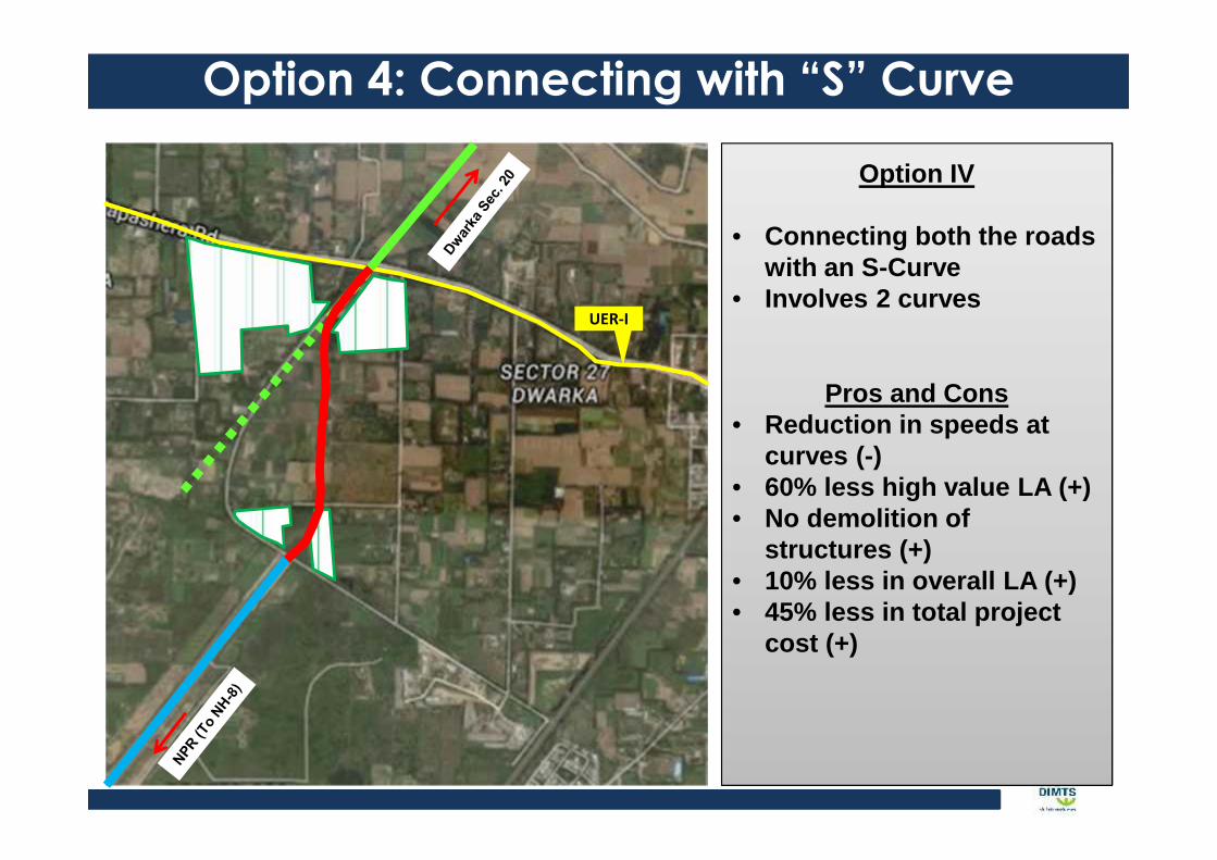
Option 4: Connecting with “S” Curve
Option IV
• Connecting both the roadswith an S-Curve
• Involves 2 curvesUER-I
Pros and Cons• Reduction in speeds at
curves (-)• 60% less high value LA (+)• No demolition of
structures (+)• 10% less in overall LA (+)• 45% less in total project
cost (+)
Simulation Results for Road Algin. OptionsRoadAlign
Inference:• Option1 less feasible from the safety and traffic point of view as it is having negligible turning radius.• Option 4 is having more benefits from the traffic maneuver and safety point of view.
Evaluation of Road Algin. Options
Alignmentoptions Distance Design
SpeedAlign. Shift in
Haryana Curves Land acquisition Cost
Option 1 - - - - - -
Option 2 1014 50 15% 4 Medium Very high
Option 3 873 100 above 60% 2 High Medium
Option 4 941 50 0% 2 Low Low
• VISSIM is taken as a tool to evaluate the alternative options in the traffic
maneuver point.
• Evaluation of alternative options has been done by taking Traffic, Travel
Speed, Delay, Safety, Land Acquisition and Cost
• Option 1 is not considered for over all evaluation as it is provide less safety
and increasing the congestion levels.
Alternative options for Junction control on UER -1 & 2
Options 1: Signalized At-Grade JunctionsOption I
• Provision of signalizedjunctions
Pros and Cons• (+) Reduce in conflict
points• (+) increasing safety at
junction• (+) Pedestrian movement• (-) increase in travel time• (-) increase in delays
Options 2: Clover Leaf at JunctionsOption II
• Upgrading junction withinterchange
• Highly lucrative option
Pros and Cons• (+) Uninterrupted traffic
flow• (+) Negligible delay• (-) Increase in merging and
diverging points• (-) Increase in project cost• (-) High land acquisition is
required
Options 3: Grade Separation across Link RoadOption III
• Grade separation acrossproject road
• U-Turn Provision toRestrict Rt. TurningMovement
Pros and Cons• (+) Reduction in delay time
for the major traffic• (+) Reduction in signal
timings• (-) Engineering constraints
due presence of Nallhaalong UER II
• (-) Economically notfeasible
• (-) Increase in project cost
Options 4: Grade Separation along Link RoadOption III
• Grade separation acrossproject road
• U-Turn Provision toRestrict Rt. TurningMovement
Pros and Cons• (+) Negligible delay time
for the major traffic• (+) Reduction in signal
timings• (-) Construction cost is
relatively high• (-) Increase in project cost
JunctionControlOptions
CycleTimings(in Sec)
QueeLengths(in Mts.)
Delays (insec)
TravelTime (in
Mins)
Option 1:At Grade(Signalization)
180 150 120 8.0
Option 2:At Gradewith“cloverleaf”
- 40 10 5.5
Option 3:Gradeseparationacross thelink road
120 60 50 5.5
Option 4:Gradeseparationalong thelink road
90 25 30 4.3
Simulation Results for Jun. Control Options
Grade Separation at UER 1
Grade Separation at UER -2
Inference:• Grade separation along the project road is considered to
be the best junction control option in traffic point of view.
Evaluation of Junction control Options
• VISSIM is taken as a tool to evaluate the alternative junction control options in
the traffic maneuver point.
• Evaluation of alternative options has been done by taking Traffic (Delay,
Queue Lengths, Travel Time), Engg. Feasibility, Environment, Social and Cost.
Design Concepts
Evaluation Criteria
Total ScoreTrafficCirculation
EngineeringFeasibility
Social/Environment Cost
Weighting (%) 50 10 10 30 100
1. Project road with all accessesare at grade Low High Medium Low High
2. Flyover with Cloverleaf atUER's Medium Medium Medium High Medium
3. Flyover at UER's with elevatedU-turn Medium Medium Medium High Medium
4. Flyover at project road High High Medium High Very High
Conclusion & Recommendation• There shall be coordination approach between different agencies of
both the states during policy and planning stage of urban transport
projects to avoid such issues.
• Evaluation of geometric design in terms of safety can be done using
micro simulation and may be made a part of the safety audit studies.
• Micro simulation VISSIM can be used for development of decision
matrix in finalizing junction type.
• Safety of road users to be given higher priority while planning of links
and use of micro simulation to be added in the policy and guidelines.