160 Humanities Alive 1 Using grid references F IT WEREN’T FOR grid references, finding places in detailed books of maps such as street directories and atlases would be very time consuming. Grid references allow the user to quickly locate the information they want among the hundreds of other features shown on a map. I It is easy to find and describe the location of a place on a map or vertical aerial photograph if you use grid references. Straight or curved lines divide maps into smaller parts. Letters and numbers placed along the sides of the grid help you give the alphanumeric grid reference for a place or feature. On the vertical aerial photograph opposite, the leader of the herd of elephants is found at A2. Place your right pointer finger on the letter ‘A’ and your left pointer finger on the number 2. Move your right finger down and your left finger across until they meet. This is grid reference A2. REMEMBER 1 What is an alphanumeric grid reference? 2 Why are the grid lines on the map of North America curved and how must grid references be read? THINK 3 Look at the aerial photograph above of elephants in Botswana. A veterinarian has been dropped at point ‘X’ on the photograph. (a) At what grid reference is the veterinarian located? (b) The veterinarian needs to treat the elephant located at C3. Why can’t she see it from her location? (c) Imagine you are in a helicopter above the elephants. Give instructions to the veterinarian about how far and in which direction she needs to travel. COMMUNICATE 4 Turn to the map of Melbourne on page 153. (a) Name the buildings located at the following grid references: Q6, O5, K7, Q3 (b) Give grid references for the following features: (i) Flagstaff Gardens (ii) Melbourne Exhibition Centre (iii) Telstra Dome (iv) Queen Victoria Markets. 5 Look carefully at the map of North America opposite. (a) In which countries are the following cities found? (i) Mexico City (J2) (ii) Chicago (K5) (iii) Yellowknife (H7) (iv) St John’s (N5) (v) Anchorage (E7) (b) Give grid references for the following capital cities. (i) Washington DC (ii) Panama City (iii) Guatamala City (iv) Ottawa (v) Reykjavik learning ✓ I CAN: use an alphanumeric grid reference system read grid references on a curved latitude/longitude grid find grid references for features on a map or aerial photograph. N x 0 5 10 15 m A E B C D 1 2 3 4
Transcript
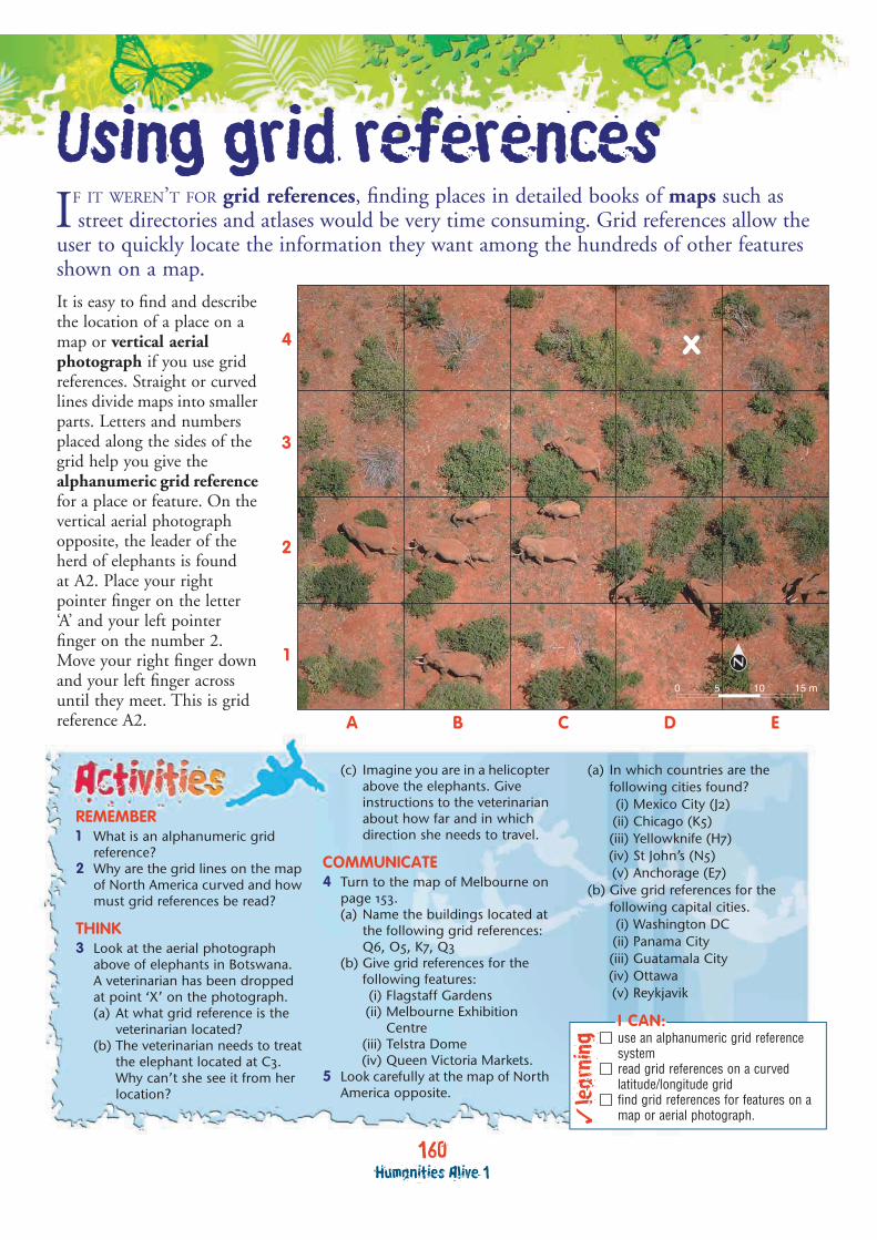
160Humanities Alive 1
Using grid referencesF IT WEREN’T FOR grid references, finding places in detailed books of maps such as street directories and atlases would be very time consuming. Grid references allow the
user to quickly locate the information they want among the hundreds of other features shown on a map.
I
It is easy to find and describe the location of a place on a map or vertical aerial photograph if you use grid references. Straight or curved lines divide maps into smaller parts. Letters and numbers placed along the sides of the grid help you give the alphanumeric grid reference for a place or feature. On the vertical aerial photograph opposite, the leader of the herd of elephants is foundat A2. Place your right pointer finger on the letter ‘A’ and your left pointer finger on the number 2. Move your right finger down and your left finger across until they meet. This is grid reference A2.
REMEMBER1 What is an alphanumeric grid
reference?2 Why are the grid lines on the map
of North America curved and how must grid references be read?
THINK3 Look at the aerial photograph
above of elephants in Botswana.A veterinarian has been dropped at point ‘X’ on the photograph.(a) At what grid reference is the
veterinarian located?(b) The veterinarian needs to treat
the elephant located at C3. Why can’t she see it from her location?
(c) Imagine you are in a helicopter above the elephants. Give instructions to the veterinarian about how far and in which direction she needs to travel.
COMMUNICATE4 Turn to the map of Melbourne on
page 153.(a) Name the buildings located at
the following grid references:Q6, O5, K7, Q3
(b) Give grid references for the following features:(i) Flagstaff Gardens(ii) Melbourne Exhibition
Centre(iii) Telstra Dome(iv) Queen Victoria Markets.
5 Look carefully at the map of North America opposite.
(a) In which countries are the following cities found?(i) Mexico City (J2)(ii) Chicago (K5)(iii) Yellowknife (H7)(iv) St John’s (N5)(v) Anchorage (E7)
(b) Give grid references for the following capital cities.(i) Washington DC(ii) Panama City(iii) Guatamala City(iv) Ottawa(v) Reykjavik
lear
ning
�
I CAN:use an alphanumeric grid reference systemread grid references on a curved latitude/longitude gridfind grid references for features on a map or aerial photograph.
N
x
0 5 10 15 m
A EB C D
1
2
3
4
161Geospatial skills
MIAMI
HOUSTON
SAN DIEGO
DALLAS
LOS ANGELES
SAN FRANCISCOWASHINGTON D.C.
KANSAS CITYCINCINNATI
INDIANAPOLIS
PHILADELPHIANEW YORKCHICAGO
BUFFALOMILWAUKEE
MINNEAPOLIS
MONTREAL
SEATTLE
VANCOUVER
CARACAS
GUADALAJARA
HAVANA
TAMPA
SAN ANTONIO
PHOENIX ATLANTA
SACRAMENTO
ST LOUIS
BALTIMOREDENVER
CLEVELAND
PROVIDENCEBOSTON
DETROIT
TORONTO
PORTLAND
MEDELLIN
MEXICO CITY
MONTERREY
NEWORLEANS
SAN JUAN
SALT LAKE CITY
Port-au-Prince
Ottawa
Tegucigalpa
Managua
MARACAIBOBarranquilla
Leon
ORLANDO
Austin JacksonvilleCiudad Juarez
El Paso
Tucson Birmingham
GreenvilleMEMPHIS
FresnoNORFOLK
Omaha
Quebec
Calgary
Edmonton
VALENCIA
Winnipeg
Kingston
SANTODOMINGO
Puebla
GUATEMALA CITY
Oklahoma City GREENSBORO
Anchorage
Reykjavik
San Salvador
SAN JOSE
Cartagena
Oaxaca de Juarez
Santiago de CubaGuantanamo
QueretaroMerida
Camaguey
Culiacan
TorreonBrownsville
Fort LauderdaleCiudad Obregon
Corpus Christi
HermosilloPensacola
SavannahJackson Columbus
Mexicali
Fort Worth
Wichita Falls
Wilmington
Little Rock
AlbuquerqueAmarillo
Bakersfield
Stockton
Pueblo
Portland
Halifax
Salem St JohnSudbury
Duluth
Fargo
Spokane
Victoria
Thunder Bay
Regina
Saskatoon
Anchorage
St John’s
Tijuana
Valera
Acapulco
Nassau
Panama City
LasVegas
Sault Ste Marie
Prince George
Butte
Sydney
Bismarck
Sept IlesPrince Albert
Kitimat
Prince Rupert
Dawson Creek
Juneau
Whitehorse
Fairbanks
Belmopan
Goose Bay-
Happy Valley
Kemano Schefferville
Hopedale
Nain
Sitka
Churchill
Fort Nelson
Skagway
SewardValdez
Fort Simpson
Frederikshab
Yellowknife
Dawson
Nome
Fort Yukon
Kugluktuk
Aklavik
Inuvik
Godhavn
Barrow
Pond Inlet
Qaanaaq
Iqaluit
Mingan
Moosonee
Fort George
Fort Severn
York Factory
Port Radium
Deering
A T L A N T I C
O C E A N
C A R I B B E A N S E A
P A C I F I C
O C E A N
Cape San Lucas
Cape Sable
Cape Mendocino
Cape Sable
Cape Bauld
Cape Chidley
Point Hope
Point Eugenia
Cape Hatteras
VENEZUELA
PANAMACOSTA RICA
HAITI
CUBA
JAMAICABELIZE
BAHAMAS
GUATEMALA
EL SALVADOR
HONDURAS
NICARAGUA
COLOMBIA
C A N A D A
U N I T E D S T A T E S O F A M E R I C A
M E X I C O
ICELAND
DOMINICANREPUBLIC
RUSSIA
UngavaPeninsula
LowerCalifornia
BoothiaPeninsula
MelvillePeninsula
SverdrupIslands
BathurstIsland
MelvilleIsland Devon
Island
SomersetIsland
BanksIsland
Prince ofWales Island
VictoriaIsland
BaffinIsland
Prince CharlesIsland
SouthamptonIsland
CoatsIsland
ManselIsland
KodiakIsland
AlexanderArchipelago
Belcher Islands
Queen CharlotteIslands
VancouverIsland
Newfoundland
Prince EdwardIsland
Queen Eliza
beth
Islan
ds
Guadalupe
EllesmereIsland
West Indies
Alaska(U.S.A.)
Greenland(Denmark)
Puerto Rico (U.S.A.)
Bermuda (U.K.)
St Pierre andMiquelon (France)
0 450 900 1350 1800 km
110˚W120˚W 100˚W
140˚W
120˚W100˚W
90˚W 80˚W 70˚W
10˚N
10˚N
20˚N
30˚N
40˚N
50˚N
60˚N70˚N80˚N70˚N60˚N
50˚N
40˚N
30˚N
20˚N
80˚W60˚W
40˚W
80˚N
D
E
F
G
I J KL
M
N
O
P
H
H I J K L M
11
2
2
3
4
5
6
78987
6
5
4
3
Azimuthal Equal Area Projection
BaffinBay
Hudson Strait
Davis Strait
FoxeBasin
Great BearLake
Great SlaveLake
McClure
Strait
ReindeerLake
LakeWinnipegosis
Lake Manitoba
Lake Winnipeg
JamesBay
LakeMistassini
Gulf ofSt Lawrence
St L
awre
nce
Rive
r
Missouri
River
River
LakeHuron
LakeOntario
Ohio
River
LakeMichigan
River
Rive
rM
issi
ssip
pi
River
River
Red
Arkansas
Grande
Florid
a Stra
it
Yucatan Channel Bayof
Campeche
Lake Maracaibo
Gulf of C
alifornia
Rio
Col
orad
o
River
GreatSaltLake
Peac
e
Mackenzie
River
Yukon
Bering S
trait
Lake Superior
Lake Erie
ARCTIC OCEAN
HudsonBay
Gulf of Mexico
BEAUFORTSEA
Arctic C
ircle
Tropic of Cancer
Nuuk
Lake Athabasca
N
N
Country capital underlined
Country name
Country border
M E X I C OOttawa
DependencyBermuda (U.K.)
More than 1 000 000 people
500 000 to 1 000 000 people
100 000 to 500 000 people
Less than 100 000 people
HAVANA
Austin
Spokane
Yellowknife
Grid references on atlas mapsMaps showing large areas of the Earth will often used curved lines of latitude (which run across the map parallel to the equator) and longitude (which run up and down a map from pole to pole) as grid lines. When reading atlas references using curved
grid lines, be sure to stay inside the grid lines at all times. For example, on the map below, the grid reference for Anchorage in Alaska is E7. If you didn’t stay within the grid lines you may have read the grid reference incorrectly.
Grid skills
worksheet 1.39
North America — political
on th
e CD-ROMAlphanumeric
grids
153Geospatial skills
Freeway
Major road
Other road
Mall
Railway
River
Parkland
Place of interest
KEY
Nic
hols
on
St
Str
eet
Rath
dow
ne
GertrudeStreet
Bru
nsw
ick
St
VictoriaParade
Street
Albert
Landsdow
ne
Str
eet
Stre
et
Sprin
g
Stre
etStre
et
Stre
et
Stre
et
Stre
et
Stre
et
Stre
et
Exhib
ition
Russell
Eliz
abeth
Queen
Willia
m
Kin
g
Spencer
Flinders
Street
Street
Street
Street
Collins
Bourke
Lonsdale
Latrobe
Adderley S
tKing
Dudley
Flinders
Street
Monta
gue
Nor
man
by
Rd
WEST GATE
FREEWAY
Grant S
t
Stre
et
Stu
rt
Str
eet
City
Road
AlexandraSouthbank
Boulevard
St K
ilda R
oad
Victoria Street
Str
eet
Lygon
Napie
r S
t
Fitzro
y S
t
Walsh St
Stanle
y
Chetw
ynd
Str
eet
Peel
Str
eet
Capel
Street
Street
Street
Batman
A’BeckettStreet
Franklin
Street
Little
Lonsdale
Street
Little
Bourke
Street
Sw
ansto
n
Walk
Stre
et
St
Street
Cla
rendon
Little
Collins
Flinders
Lane
Kin
gs
Way
Way
Kings
Wells
S
treet
Dodds S
treet
Miles St
StSt
Brady
Munro
Street
Street
Ferra
rs St
Whi
tem
an S
t
Hai
g
Stre
etCla
rkeS
t
MarketSt
Kav
anag
h
Stre
et
Street
LorimerLorimer
Gore
S
t
Georg
e S
t
Cla
rendon S
treet
Wellington Parade
Jolim
ont R
d
BruntonAvenue
Jolimont St
Swan Street
Batm
an
Ave
nue
Avenue
Stre
et
Rod
en
StreetS
tree
t
Street
Moore
S
tBourke S
treet Mall
St
C. Grimes
Bridge
BatmanPark
Kings
Domain
MelbournePark
Fitzroy
Gardens
CarltonGardens
South
Flagstaff
Gardens
Treasury
Gardens
OrnamentalLake
Rosslyn
Haw
ke
Spencer
StreetA
dderley Street
Docklands
Highw
ay
Harbour
Esp
TelstraDome
Docklands
QueenVictoriaMarkets
State Housesof
Parliament
FederationSquare
NationalGallery ofVictoria
MCGRod Laver
Arena
Olympic Park
GovernmentHouse
Crown Entertainment
Complex
MelbourneExhibition
Centre
YarraPark
Footbridge
Footbridge
Footbridge
Footbridge
Tunnel
Tunnel
Flinders StStation
Spencer StStation
Parliament
MelbourneCentral
Flagstaff
VictoriaHarbour
Spencer St
Bridge
Kings
Bridge
Queens
Bridge
Princes
Bridge
Swan StBridge
YARRA
RIV
ER
MELBOURNE
MELBOURNE
SOUTHBANK
DOCKLANDS
JOLIMONT
EAST
MELBOURNE
WEST
MELBOURNE
A B C D E F G H I J K L M N O P Q R
A
1
2
3
4
5
6
7
8
9
10
11
12
13
1
2
3
4
5
6
7
8
9
10
11
12
13
B C D E F G H I J K L M N O P Q R
0 400 m200 N
Using a map legendThe legend is a key that lists and explains the colours and symbols used on the map. Many maps use the same symbols to help the reader instantly recognise features; for example, blue lines to represent rivers. The key is usually found next to the map or it may be located in a special reference section.
REMEMBER1 Why are maps useful?2 What does BOLTSS stand for?
COMMUNICATE3 What is the large white rectangle
shown on the satellite image? How did you find out what it was?
4 List two features on the satellite image of Melbourne that are not shown on the map.
5 List two features on the satellite image that you needed the map to identify.
6 Observe the Westgate freewayon the satellite image and the map.(a) What appears to happen to the
freeway when it meets the Kings Domain park on the satellite image?
(b) What extra information on the map tells us what actually happens when it meets the Kings Domain park?
7 Sketch the symbols from the map legend that the cartographer has used to show rivers, railway lines and parks. Suggest why these symbols and colours were chosen.
8 Design your own symbols to show bridges, skyscrapers and football stadiums.
lear
ning
�
I CAN:see that maps and photographs have different usesappreciate that symbols used on maps make features easier to locatedesign my own symbols to be used in a legend or key.


![Photovoltaics merging with the active integrated grid Grid ... · Three different references have been used with success in grid integration studies: í X Z ] v P ~ ] v ls } ( Z v](https://static.documents.pub/doc/80x56/5f07247c7e708231d41b845c/photovoltaics-merging-with-the-active-integrated-grid-grid-three-different-references.jpg)


